FINAL SUPPLEMENTAL ENVIRONMENTAL ASSESSMENT (SEA) FOR MODIFICATION OF AIRSPACE UNITS R-3008A/B/C FROM VISUAL FLIGHT RULES (VFR) TO VFR-INSTRUMENT
|
|
|
- Joshua Heath
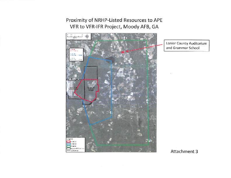
- 6 years ago
- Views:
Transcription

 AT MOODY AIR FORCE BASE,")
1 FINAL SUPPLEMENTAL ENVIRONMENTAL ASSESSMENT (SEA) FOR MODIFICATION OF AIRSPACE UNITS R-3008A/B/C FROM VISUAL FLIGHT RULES (VFR) TO VFR-INSTRUMENT FLIGHT RULES (IFR) AT MOODY AIR FORCE BASE, GEORGIA
2
3 FINAL SUPPLEMENTAL ENVIRONMENTAL ASSESSMENT (SEA) FOR MODIFICATION OF AIRSPACE UNITS R-3008A/B/C FROM VISUAL FLIGHT RULES (VFR) TO VFR-INSTRUMENT FLIGHT RULES (IFR) AT MOODY AIR FORCE BASE, GEORGIA
4 Printed on Recycled Paper
5 TABLE OF CONTENTS Table of Contents Page DRAFT SUPPLEMENTAL ENVIRONMENTAL ASSESSMENT (SEA) FOR MODIFICATION OF AIRSPACE UNITS R-3008A/B/C FROM VISUAL FLIGHT RULES (VFR) TO VFR-INSTRUMENT FLIGHT RULES (IFR) AT MOODY AIR FORCE BASE, GEORGIA... TABLE OF CONTENTS... i List of Tables... ii List of Figures... ii Acronyms, Abbreviations, and Symbols... iii 1. PURPOSE AND NEED FOR ACTION Introduction Location of the Proposed Action Purpose and Need for the Action Scope of the Environmental Review Cooperating Agency and Intergovernmental Coordination/Consultations and Public/Agency Review DESCRIPTION OF PROPOSED ACTION AND ALTERNATIVES Introduction Proposed Action Selection Standards Screening of Alternatives No Action Alternative Identification of the Preferred Alternative Impact Summary Environmental Issues Not Carried Forward for Detailed Analysis Summary of Environmental resources in the SEA ENVIRONMENTAL CONSEQUENCES Airspace Definition of the Resource Existing Conditions Environmental Consequences Safety Definition of the Resource Existing Conditions Environmental Consequences CUMULATIVE IMPACTS PAST, PRESENT, AND REASONABLY FORESEEABLE FUTURE ACTIONS Airspace Safety SPECIAL OPERATING PROCEDURES AND MITIGATIONS i
6 Table of Contents 6. PERSONS / AGENCIES CONTACTED LIST OF PREPARERS REFERENCES LIST OF TABLES Table 2-1. Alternative Impact Summary and Comparison Table 4-1. Past, Present, and Reasonably Foreseeable Future Actions LIST OF FIGURES Figure 1-1. Location of Moody AFB Figure 1-2. Airspace Affected by the Proposed Action Figure 3-1. National Airspace System Figure 3-2. R-3008 and Surrounding Airspace Figure 3-3. Special Use Airspace Surrounding R Figure 4-1. Moody MOA 1 Sub Areas ii
7 Table of Contents ACRONYMS, ABBREVIATIONS, AND SYMBOLS AFB Air Force Base AFI Air Force Instruction AGL above ground level APE Area of Potential Effects ATC air traffic control BASH bird/wildlife-aircraft strike hazard C.F.R. Code of Federal Regulations CEQ Council on Environmental Quality db decibels DNL day-night average sound level DNR (Georgia) Department of Natural Resources DoD Department of Defense EA Environmental Assessment EIS Environmental Impact Statement EO Executive Order ESA Endangered Species Act of 1973 FAA Federal Aviation Administration FY Fiscal Year GNAHRGIS Georgia Natural, Archaeological, Historic Resources Geographic Information System IFR instrument flight rules MDS Mission Design Series MOAs Military Operations Areas MSL mean sea level MTRs military training routes NAAQS National Ambient Air Quality Standards NEPA National Environmental Policy Act NOISEMAP a noise modeling software program NOTAM Notice to Airmen NRHP National Register of Historic Places NWR National Wildlife Refuge RAPCON Radar Approach Control RNM Rotorcraft Noise Model ROI region of influence SEA Supplemental Environmental Assessment SHPO State Historic Preservation Officer SUA special use airspace TCPs TFR traditional cultural properties Temporary Flight Restriction U.S.C. United States Code ULZ Unimproved Landing Zone USEPA U.S. Environmental Protection Agency USFWS U.S. Fish and Wildlife Service VFR visual flight rules iii
8 Table of Contents THIS PAGE IS INTENTIONALLY BLANK. iv
9 1. PURPOSE AND NEED FOR ACTION 1.1 INTRODUCTION Pursuant to provisions of the National Environmental Policy Act (NEPA), 42 U.S.C to 4270d, implementing Council on Environmental Quality (CEQ) Regulations, 40 Cod of Federal Regulations (C.F.R.) , and 32 C.F.R. Part 989, Environmental Impact Analysis Process, in 2015 the U.S. Air Force (Air Force) assessed the potential environmental consequences associated with changing the weather operations category of Grand Bay Range and the overlying airspace, Restricted Area R-3008 (R-3008), at Moody Air Force Base (AFB), Georgia, from visual flight rules (VFR) to VFR-instrument flight rules (VFR-IFR). This action would minimize the number of training hours lost by allowing full utilization of Grand Bay Range during periods of inclement weather that require instrument flying. Normal range operational hours in this Environmental Assessment (EA) were defined as being 8:00 AM to 1:30 AM Monday Thursday; 8:00 AM to 5:00 PM on Friday, with other times such as reserve weekends and exercises scheduled on a case by case basis. In September 2015 the Air Force concluded that implementation of the proposed action cumulatively with other projects at Moody AFB would not result in significant environmental impacts. Accordingly, an Environmental Impact Statement (EIS) was not required, and a Finding of No Significant Impact (FONSI) was approved on 30 Sep 15. Grand Bay Range and the associated overlying airspace, R-3008 A/B/C/D, is permanently published to be active from 7:00 AM to 10:00 PM Monday through Friday and at other times by Notice to Airman (NOTAM). A NOTAM is a notice containing information not known in advance concerning the establishment, condition, or change, in the National Airspace System, the timely knowledge of which is essential to personnel concerned with flight operations. Published hours are permanently listed in the Federal Aviation Administration (FAA) special use airspace regulation The permanent schedule denotes long term schedules and are used by the aviation community for advanced flight planning. Since 1997 Grand Bay Range has extended the scheduled hours of operation by activating R-3008 from 10:00 PM until 1:30 AM Monday through Thursday by issuing a daily NOTAM. The Air Force proposes to change the method of communicating the normal hours of active range operations Monday through Thursday by changing the published hours to more accurately reflect the current hours of operations. The current method is a combination of the published schedule and a daily NOTAM. Specifically, the Air Force proposes to amend the published scheduled R-3008A/B/C/D times of operation from 1-1
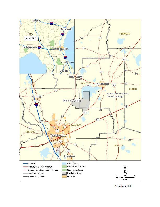
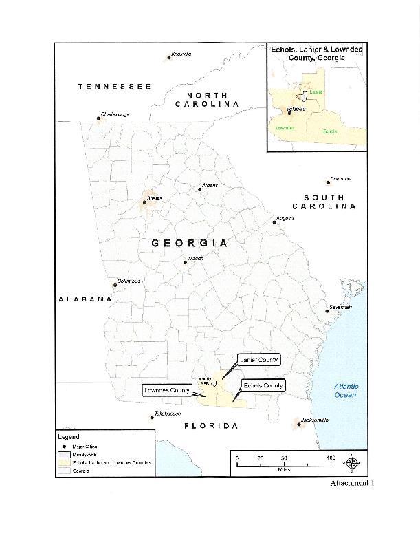
10 7:00 AM to 10:00 PM Monday through Friday and at other times by NOTAM to 8:00 AM to 1:30 AM Monday-Thursday; Friday from 7:00 AM to 10:00 PM, and at other times by NOTAM to more accurately indicate to the flying public the actual usage times of R There is no proposed change to the actual flying hours, usage, or to flight operations. The change is to permanently publish the current operational hours in FAA Order instead of issuing a daily NOTAM Monday through Thursday. Friday and weekend published hours remain unchanged. The environmental effects of conducting flying operations during these hours were previously assessed in the Grand Bay Range VFR to VFR IFR environmental assessment and are within scope of the analysis. The Environmental Assessment for Modification of Airspace Units R-3008A/B/C/D From Visual Flight Rules (VFR) to VFR-Instrument Flight Rules (IFR) at Moody Air Force Base, Georgia and FONSI are hereby incorporated by reference in this supplemental assessment. 1.2 LOCATION OF THE PROPOSED ACTION Moody AFB comprises a total of 11,881 acres in Lowndes and Lanier Counties in south-central Georgia, which includes the Main Base, Grand Bay Range, and Grassy Pond. Nearby cities include Valdosta, about 10 miles to the southwest, and Lakeland, about 6 miles northeast. Moody AFB is approximately 85 miles northeast of Tallahassee, Florida, and 120 miles northwest of Jacksonville, Florida. The closest major cities in Georgia are Macon, 150 miles north, and Atlanta, 220 miles north. Georgia State Highway 125 (Parker Greene Highway/Bemiss Road) is the primary access road to the main base. The main base portion, situated east of Parker Greene Highway/Bemiss Road (State Highway 125), includes the administrative, base support, aircraft operations, and maintenance areas, as well as the airfield. The location of the Proposed Action is the airspace over Grand Bay Range, referred to as R-3008 A/B/C/D. Figure 1-1 and 1-2 show the location of Moody AFB and the affected airspace. 1-2

11 Figure 1-1. Location of Moody AFB 1-3

12 Figure 1-2. Airspace Affected by the Proposed Action 1-4
13 1.3 PURPOSE AND NEED FOR THE ACTION The purpose of the Proposed Action is to more accurately indicate to the flying public the actual usage times of Grand Bay Range and R-3008 and to eliminate the requirement to publish a short notice daily NOTAM. This action is needed because Air Force Instruction (AFI) paragraph states NOTAMs shall be temporary in nature, not exceeding 90 days. Although publishing a NOTAM Monday through Thursday does not technically exceed 90 consecutive days, it violates the spirit of the regulation. Changing the published hours to accurately reflect routine restricted area operations would provide a consistent schedule to the flying community, thus enabling advanced flight planning to avoid the restricted area. 1.4 SCOPE OF THE ENVIRONMENTAL REVIEW This Supplemental Environmental Assessment (SEA) identifies, describes, and evaluates the potential environmental impacts that may result from implementing the Proposed Action as well as a no action alternative. As appropriate, the affected environment and environmental consequences may be described in terms of sitespecific descriptions or regional overview. In addition, the document identifies measures that would prevent or minimize environmental impacts. The National Environmental Policy Act requires Federal agencies to consider the environmental consequences of proposed actions in the decision-making process (U.S.C. 4321, et seq.). The CEQ was established under NEPA, 42 U.S.C. 4342, et seq., to implement and oversee Federal policy in this process. In 1978, the CEQ issued regulations implementing the NEPA process under Title 40, C.F.R., Parts The CEQ regulations require that the Federal agency considering an action evaluate or assess the potential consequences of the action or alternatives to the action, which may result in the need for an EA or EIS. Under 40 C.F.R.: An EA must briefly provide sufficient evidence and analysis to determine whether a finding of no significant impact or an EIS should be prepared. An EA must facilitate the preparation of an EIS if required. NEPA imposes a continuing duty on Federal agencies to evaluate and gather new information relevant to the environmental impacts of their actions. However, when important new information becomes available after an EA or EIS is prepared, an agency may satisfy its duty under NEPA with a supplemental analysis. An agency must prepare a supplemental EA or EIS when the agency makes substantial changes in the 1-5
14 proposed action that are relevant to environmental concerns or if there are significant new circumstances or information relevant to environmental concerns and bear on the proposed action or its impacts. The supplement focuses on only those actions / elements or potentially affected environment that are different or have changed from what was understood at the time the original EA or EIS was prepared. An agency does not need to analyze what is already covered in the previous analysis. An agency may supplement a draft or final EA or EIS. An agency must prepare, circulate, and file a supplement in the same manner as a draft and final statement unless CEQ approves alternative procedures. The proposed action addressed within this document constitutes a Federal action and, therefore, must be assessed in accordance with NEPA. Though the actual flying activities do not change from the previous assessment, the proposed action of permanently changing the range hours to match hours currently issued by NOTAM constitutes a change in proposed action from the original EA. To comply with NEPA, as well as other pertinent environmental requirements, the decision-making process for the Proposed Action must include the development of a SEA to address the environmental issues related to the proposed action. The Air Force Environmental Impact Analysis Process is accomplished via procedures set forth in CEQ regulations and 32 C.F.R. Part COOPERATING AGENCY AND INTERGOVERNMENTAL COORDINATION/CONSULTATIONS AND PUBLIC/AGENCY REVIEW This section describes the notification, coordination, and consultation processes for agencies, Native American tribes, and the public. The FAA was a cooperating agency on the original VFR to VFR-IFR Environmental Assessment. Because this assessment supplements the original EA, the FAA will be a cooperating agency. The FAA was involved in the development of this EA. Once the EA is finalized, the FAA will conduct its own NEPA process per FAA Order , Procedures for Handling Airspace Matters. As part of the intergovernmental coordination process, the Air Force provided notification of, and sought input on, the Proposed Action from the following agencies: the FAA, Georgia Department of Community Affairs, Georgia Wildlife Resources Division, U. S. Fish and Wildlife Service (USFWS) Ecological Services, USFWS Banks Lake National Wildlife Refuge (NWR), Georgia Environmental Protection Division, Georgia Historic Preservation Division, South Georgia Regional Planning Council, the Lanier and Lowndes County Commissions, and the Valdosta Airport Authority. 1-6
15 (Public Involvement: Agency, Tribal, and Public Coordination/Notification) includes correspondence with these agencies. On May 23rd 2017, Moody AFB completed consultation under 54 U.S.C (commonly known as Section 106 of the National Historic Preservation Act) with the Georgia State Historic Preservation Office (SHPO) for potential impacts to cultural resources. The Moody AFB point of contact for consultation with the SHPO and the Advisory Council on Historic Preservation is the Cultural Resources Manager. On May 23 rd, 2017 the Georgia SHPO concurred that no historic resources would be affected by this proposed action (see ). Moody AFB completed Endangered Species Act (ESA) Section 7 consultation on 2 November 2016 with the USFWS, which concurred that the proposed action is not expected to significantly impact fish and wildlife resources. The USFWS consultation correspondence is included in Appendix A. Native American Tribal Consultation. Executive Order (EO) 13175, Consultation and Coordination with Indian Tribal Governments, directs federal agencies to develop a government to government relationship with Native American tribal governments whose interests might be directly and substantially affected by activities on federally administered lands. To comply with legal mandates, federally recognized tribes affiliated historically with the Moody AFB geographic region are invited to consult on all proposed undertakings that have a potential to affect properties of cultural, historical, or religious significance to the tribes. The tribal coordination process is distinct from NEPA consultation or the interagency/intergovernmental coordination processes and requires separate notification of all relevant tribes by Moody AFB. The timelines for tribal consultation are also distinct from those of intergovernmental consultations. The Moody AFB pointof contact for Native American tribes is the Installation Commander. A complete listing of the Native American tribal representatives consulted and Air Force correspondence may be found in. The proposed action was announced in the Federal Register on February 4 th, 2014 ( The Air Force published a public notice in the Valdosta Daily Times and the Lanier County Advocate on 27 September 2017, inviting the public to review and comment on the EA, which was made available at the South Georgia Regional Library in Valdosta, Georgia, and on the Moody AFB website at Initiative/. The public comment period ended on 27 October No public or agency comments were received. 1-7
16 THIS PAGE IS INTENTIONALLY BLANK. 1-8
17 2. DESCRIPTION OF PROPOSED ACTION AND ALTERNATIVES 2.1 INTRODUCTION This chapter describes the Proposed Action, the alternatives that the Air Force considered but did not carry forward, and the No Action Alternative. The potential environmental impacts of the Proposed Action and alternatives are summarized at the end of this chapter. 2.2 PROPOSED ACTION The Proposed Action is to change the method of notification for R-3008 to eliminate the requirement for a short notice daily NOTAM. Once changed, there would no longer be a requirement to publish daily short notice NOTAMs to conduct routine operations on R-3008 and FAA products would accurately reflect 23d Wing s normal utilization window for R Under the Proposed Action there is no proposed change to actual flying operations and there would be no change in flight patterns, types of aircraft utilized, types of training, or distribution of day/night operations from the current condition. As discussed in Section 1.3, the Proposed Action would provide advance notice of the restricted area operations to the flying community to enhance flight planning. All operations would remain in compliance with FAA and Department of Defense (DoD) guidelines for Special Use Airspace (SUA). 2.3 SELECTION STANDARDS Selection standards are used to identify alternatives for meeting the purpose and need for an Air Force action. In addition, selection standards may be used to narrow the range of alternatives to focus analyses, so as to meet the directive that environmental analyses be analytic rather than encyclopedic. Given the scope of the purpose and need as described previously in Section 1.3, the following selection standards have been identified: 1) Accurately reflect current airspace utilization as planned in beddown and subsequent assessments in order to meet flying training requirements for all Moody based aircraft. 2) Meet FAA airspace notification requirements to inform the flying public of restricted area hours of operation. 2-1
18 3) Comply with AFI NOTAM requirements. 2.4 SCREENING OF ALTERNATIVES In compliance with NEPA and 32 C.F.R. 989, which implements the NEPA process, the Air Force must consider reasonable alternatives to the Proposed Action. The following potential alternatives that might meet the purpose and need for more accurately indicating to the flying public the actual usage of Grand Bay Range and R were considered: 1) Permanently change R-3008 published operational hours to 0800L to 0130L (8:00 AM to 1:30 AM) Monday through Thursday, Friday from 0700L to 2200L (7:00 AM to 10:00 PM); other times by NOTAMs six hours in advance. As a result of this alternative, training would continue at currently assessed levels and the flying public would be provided advanced and more accurate information on the restricted area s actual usage. There would no longer be a requirement to issue daily short notice NOTAMs to alert the flying public of the actual restricted area operational hours. Actual operational hours for the range would not change, and there would be no change in airspace size, location, traffic patterns, or types of events. (preferred alternative) 2) Utilize other ranges for training outside published R-3008 hours. This alternative would involve utilization of other range complexes outside of Moody AFB. Flight patterns and transit times would be altered to accomplish training at other ranges for training requirements outside of the current R published hours. Grand Bay Range and R-3008 would cease operations at 10:00 PM each weeknight and other range airspace would be utilized. No daily NOTAM would be issued. 3) Utilize Grand Bay Range only during hours of published operations. This alternative would involve only conducting range operations during published hours. No daily NOTAM would be issued. Grand Bay Range and R-3008 would cease operations at 10:00 PM each weeknight. This alternative would result in a decrease of available range time for Moody AFB based aircrews. 2-2
19 The selection standards described in Section 2.3 were applied to the alternatives listed above to determine which alternative(s) would fulfill the purpose and need for the action. The following alternatives have been eliminated from further consideration because they do not meet the selection standards associated with the purpose and need: Utilize other ranges for training outside published R-3008 hours. This alternative was eliminated because it would involve utilizing ranges that are not under control of Moody AFB scheduling and does not facilitate current airspace utilization to meet flying training requirements for Moody based aircraft (selection criteria 1). This alternative alters the training and airspace utilization as planned in beddown documents. This alternative also does not provide a solution for all Moody-based aircraft due to the transit limitations of rotary wing aircraft. Travel time to other ranges would result in a loss of training hours, increase in transit time, additional fuel costs, and expanded airfield hours to accommodate lost training hours due to transit time to other ranges. This alternative reduces training beyond levels planned in beddown documents, alters the airspace utilization and thus does not meet selection criteria 1. Utilize Grand Bay Range only during hours of published operations. This alternative was eliminated because it does not facilitate current airspace utilization to meet flying training requirements for all Moody based aircraft (selection criteria 1). Current flying training requirements that included R-3008 operations until 0130 were identified in aircraft beddown planning assessments and are required to meet each of the current flying units training needs. Reducing the available range hours below the minimum will result in Moody AFB based flying units not meeting planned and directed training requirements. 2.5 NO ACTION ALTERNATIVE As discussed previously, current airspace utilization requires the issuance of a daily short notice NOTAM to extend R-3008 airspace operational hours Monday through Thursday. The No Action Alternative would continue to require a daily NOTAM and short notice notification to the flying public of the actual hours of R-3008 operations. This will continue to violate the spirit of AFI paragraph in reference to NOTAMs being temporary in nature. 2-3
20 2.6 IDENTIFICATION OF THE PREFERRED ALTERNATIVE Alternative screening indicates that the only alternative that meets all the selection standard requirements and the purpose and need is to permanently change the R-3008A/B/C/D published hours of operation. Therefore, this is the Air Force s Preferred Alternative and the Proposed Action discussed within the context of this EA. The Proposed Action is the only action alternative carried forward for analysis. 2.7 IMPACT SUMMARY Environmental Issues Not Carried Forward for Detailed Analysis Based on the scope of the Proposed Action, resource areas with minimal or no impacts were identified through a preliminary screening process. The following describes the resource areas not carried forward for detailed analysis, along with the rationale for their elimination. The proposed action only changes the notification method for R-3008 hours of operation, not actual flying operations. Therefore, incorporation of the impacts identified in the original VFR to VFR-IFR EA would result in no change in baseline conditions for implementing the supplemental EA Proposed Action. The following resource areas were not analyzed in detail in this SEA because the Proposed Action would not interact with these resources and, therefore, there would be no potential impact or change in the current condition of the resource. Noise: Noise is considered to be unwanted sound that interferes with normal activities or otherwise diminishes the quality of the environment. Under the Proposed Action, flying operations would continue to operate the same as it does under current conditions. Noise levels would not change relative to current noise levels, and there would be no new noise impacts. Land use: This resource encompasses current uses of land within the Proposed Action s region of influence (ROI) (e.g., agriculture, recreation, commercial, residential). Analysis would focus on whether the Proposed Action would change or affect current land use designations and usage. Since there is no proposed change to flying operations, there would be no change in land use designations or effects on usage under the airspace affected by the Proposed Action. Air quality: Air quality is determined by the type and amount of pollutants emitted into the atmosphere, the size and topography of the air basin, and the prevailing meteorological conditions. The Proposed Action would continue operations in the 2-4
21 airspace as it does under current baseline conditions, therefore no additional impacts to Air Quality were identified. Infrastructure: This resource encompasses physical and organizational structures, roads, and utilities within the Proposed Action s ROI. Analysis would focus on whether the Proposed Action would affect existing infrastructure, require new infrastructure, or result in new or increased utilities usage. The Proposed Action does not involve use of, or interaction with infrastructure or utilities. Geologic resources: Geologic resources include soils and underlying geologic resources within the ROI; analysis would focus on effects on these resources from ground-disturbing activities and other actions. The Proposed Action does not involve any ground disturbance. Water resources: Water resources include surface water, groundwater, wetlands, and floodplains within the ROI; analysis would focus on impacts to these resources from proposed activities. The Proposed Action does not involve use or disturbance of water resources. Solid/hazardous materials and waste: This resource area addresses the use of solid and hazardous materials and the production of associated wastes. Analyses would focus on whether the Proposed Action would require the use of any of these materials, whether wastes would be produced, how these would be disposed of, and any potential effects to waste disposal processes or facilities. The Proposed Action would not increase use of fuels and other solid and hazardous materials associated with current utilization of the range. Therefore, no adverse impacts are anticipated and this issue was not analyzed in detail. Biological Resources: For purposes of this EA, biological resources include plant and animal species and the habitats in which they occur. The airspace would continue to operate as it does under current conditions and, therefore, potential occurrences of wildlife disturbance or direct strikes would also remain at current levels. Other effects to wildlife resulting from aircraft operations would remain the same as those under existing conditions. On 2 November 2016 USFWS concurred that the proposed action is not expected to significantly impact fish and wildlife resources. The USFWS consultation correspondence is included in. No significant impact to biological resources are expected from implementation of this proposed action. Therefore, Biological Resources was not carried forward for further, detailed analyses. Cultural Resources: Cultural resources consist of prehistoric and historic sites, structures, artifacts, and any other physical or traditional evidence of human activity considered relevant to a particular culture or community for scientific, traditional, 2-5
22 religious, or other reasons. As defined under 32 C.F.R. 800 (l)(1), Historic Property means any prehistoric or historic district, site, building, structure, or object included in, or eligible for inclusion in, the National Register of Historic Places (NRHP) maintained by the Secretary of the Interior. A search of the Georgia Department of Natural, Archeological, and Historical Resources Geographic Information System (GNAHRGIS) database and the NRHP did not identify any new listings since the VFR-IFR EA analyzed cultural resources. Additionally, Moody AFB provided notification of, and request for input on, the Proposed Action to Native American tribes as part of the government-to-government consultation process as identified in Executive Order 13175, Consultation with Indian Tribal Governments. These tribal governments, as well as the Georgia SHPO, were consulted regarding impacts to cultural and tribal resources under 54 U.S.C (commonly known as Section 106 of the National Historic Preservation Act). On May 23rd, 2017 Moody AFB completed consultation with the Georgia SHPO for potential impacts to cultural resources. The SHPO concurred that no historic resources would be affected by this proposed action. The Seminole Nation of Oklahoma expressed concern that flying operations in this area have a potential to affect archaeological resources, some of which may be eligible for listing on the National Register of Historic Places but recommended a finding of No Adverse Effect. This corresponds with the finding on cultural resources in the original EA which assessed the impact from increasing flying operations to the current levels. There have been no known changes to the baseline cultural resources that were analyzed in the VFR-IFR EA, the proposed action does not change flying operations, therefore, cultural resources was not carried forward for detailed analysis. A list of tribes contacted and associated tribal and SHPO consultation correspondence is provided in (Public Involvement: Agency, Tribal, and Public Coordination/ Notification). Environmental justice: Environmental justice addresses the potential for disproportionate impacts to low-income and minority populations per Executive Order (Federal Actions to Address Environmental Justice in Minority Populations and Low- Income Populations). Because the Proposed Action does not include any changes from baseline conditions, no disproportionate impacts to low income or minority populations are anticipated from the Proposed Action. As a result, environmental justice was not carried forward for further, detailed analyses. Socioeconomics: Socioeconomics involves analyzing potential impacts to the local economy. Because there are no proposed changes from baseline conditions established in the VFR-IFR EA, no impacts to local economies have been identified as a result of the Proposed Action. Therefore, Socioeconomics was not carried forward for further, detailed analyses. 2-6
23 2.7.2 Summary of Environmental resources in the SEA Table 2-1. Alternative Impact Summary and Comparison Resource / Issue Area Airspace Safety Proposed Action No significant adverse impacts have been identified. The Proposed Action would only involve a change in the method of notification for R-3008 airspace hours of operation. This would provide advanced notice of actual range hours and allow aviation operations better information for flight planning. Due to the proposed improvement in airspace notification, the Proposed Action would result in a potential increase in Flight Safety and a potential decrease in restricted airspace intrusions. Currently, the flying public is notified of the range hours extending from 10:00 PM to 1:30 AM via a daily NOTAM. Though pilots are required to check NOTAMs prior to flight, advance notice of the range operational hours by publishing the actual hours in a schedule will permit a stabilized representation of the actual operational hours. NOTAMs will only be issued when there is truly a change to the schedule. No significant adverse impacts to safety would be expected with implementation of the proposed action. BASH = bird/wildlife aircraft strike hazard No Action R-3008 airspace would continue to operate as it does under current conditions, and there would be no change. As a result, the No Action Alternative would not result in any additional impacts to airspace beyond the scope of normal conditions and influences within the region. Under the No Action Alternative, the airspace would continue to operate as it does under current conditions. Therefore, the likelihood of aircraft mishaps or BASH would remain as under current conditions. With the continuation of policies and procedures in place to ensure the safety of the public as well as military personnel, there would be no adverse impacts associated with the No Action Alternative. 2-7
24 THIS PAGE IS INTENTIONALLY BLANK 2-8

25 3. ENVIRONMENTAL CONSEQUENCES 3.1 AIRSPACE Definition of the Resource The nation s airspace is structured and managed by the FAA in a manner that most safely and efficiently serves both civilian and military interests. Airspace is broadly classified into four different types of airspace; Controlled, Uncontrolled, Special use, or Other. Controlled and Uncontrolled airspace is further subdivided into 6 types of airspace, A through G (F is not used in the United States). Figure 3-1. National Airspace System Controlled Airspace - Airspace designated as Class A, B, C, D, or E is controlled airspace, meaning the FAA regulates and actively controls aircraft operations in that airspace. Class A encompasses the enroute, high-altitude environment used by aircraft to transit from one area of the country to another. All aircraft in Class A must operate under IFR. Class A airspace exists within the United States from 18,000 feet MSL to and including 60,000 feet MSL. Class B airspace exists at 29 high-density airports in the United States as a means of managing air traffic activity around the airport. It is designed to regulate the flow of air traffic above, around, and below the arrival and departure routes used by air carrier aircraft at major airports. Class B airspace generally includes all airspace from an airport s established elevation up to 12,000 feet MSL, and, at varying altitudes, out to a distance of about 30 nautical miles from the center of the airport. Class C airspace is defined around airports with airport traffic control towers 3-1
26 and radar approach control. It normally has two concentric circular areas with a diameter of 10 and 20 nautical miles. Variations in the shape are often made to accommodate other airports or terrain. The top of Class C airspace is normally set at 4,000 feet AGL. Class D airspace is under the jurisdiction of a local Air Traffic Control Tower (ATCT). Class D airspace is normally a circular area with a radius of five miles around the primary airport. This controlled airspace extends upward from the surface to about 2,500 feet AGL. Class E airspace is a general category of controlled airspace that is intended to provide air traffic service and adequate separation for IFR aircraft from other aircraft. In the eastern United States, Class E airspace generally exists from 700/1200 feet AGL to the bottom of Class A airspace at 18,000 feet MSL. It generally fills in the gaps between Class B, C, and D airspace at altitudes below 18,000 feet MSL. The nation s airways below 18,000 MSL are classified as Class E airspace. (FAA, 2014a) Uncontrolled Airspace - Airspace not designated as Class A, B, C, D, or E is considered uncontrolled Class G airspace. ATC does not have the authority or responsibility to manage air traffic within this airspace and the airspace is open for VFR use by military and civilian aircraft. In the Eastern U.S., Class G airspace lies between the surface and 1200 feet AGL or adjusted for local conditions. For the ROI of this EA, the Class G airspace is the airspace under R-3008B and R-3008C. Special Use Airspace - Large segments of controlled and uncontrolled airspace have been designated as special use airspace. Operations within special use airspace are considered hazardous to civil aircraft operating in the area. Consequently, civil aircraft operations may be limited or even prohibited, depending on the area. R-3008A/B/C/D and the Moody Military Operations Areas (MOA) are classified as Special Use Airspace. Other - Other airspace comprises both controlled and uncontrolled airspace that supports flight operations that require extra vigilance. Examples of other airspace are Military Training Routes (MTR), Temporary Flight Restrictions (TFR), and VFR Corridors. MTRs are routes that are frequently flown by military aircraft. Nonparticipating aircraft are not prohibited from operating within MTRs, but should exercise vigilance for frequent military traffic. TFRs are areas of controlled and uncontrolled airspace where the FAA publishes temporary restrictions, such as an area with active aerial firefighting operations or in areas of volcanic activity. VFR Corridors are airspace designated to accommodate the transit of uncontrolled traffic through controlled airspace, such as Class B airspace surrounding a busy airport. (FAA, 2014a) Existing Conditions The existing airspace environment within the ROI for this resource area includes R-3008A/B/C/D and the Class G airspace under R-3008B/C. 3-2


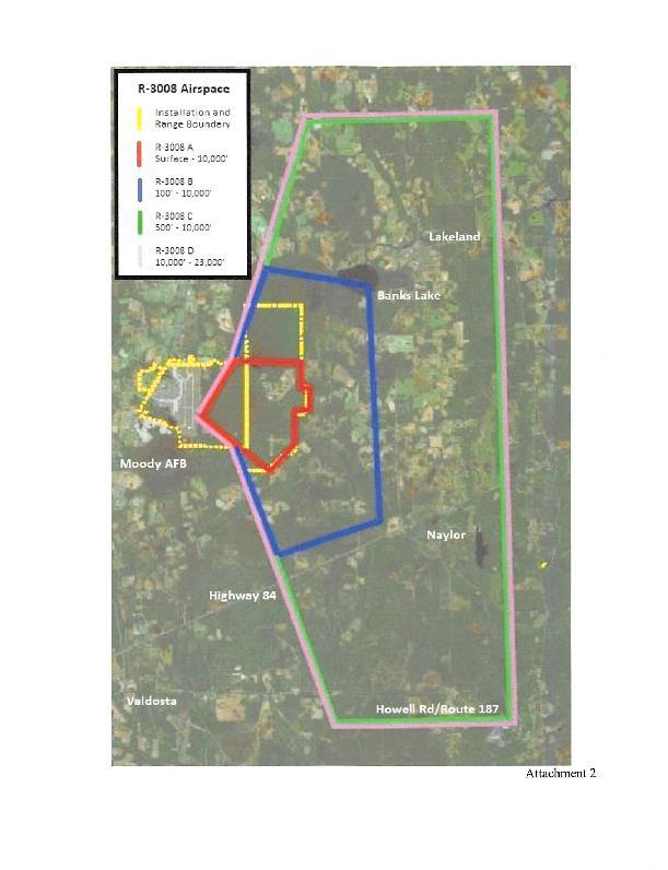
27 Figure 3-2. R-3008 and Surrounding Airspace The R-3008A/B/C/D restricted areas are a type of SUA that the FAA has specifically designated to contain and protect hazardous air and ground activities, such as those conducted on Grand Bay Range. When restricted areas are activated by the using agency for these types of operations, any flight by nonparticipating aircraft within this airspace, while not wholly prohibited, is subject to restrictions. Entry into an active restricted area without authorization from the using/controlling agency may put both participating and nonparticipating aircraft at risk. The airspace discussion addresses 3-3
28 only those FAA-designated airspace types/classifications considered relevant to the Proposed Action (FAA, 2014a). The R-3008 restricted area supporting Grand Bay Range operations is subdivided into the four subareas as shown in Figure 3-2. As noted on this figure, the smaller A subarea extends from the range surface up to 10,000 feet above mean sea level (MSL), while the outer B and larger C subareas start at 100 feet and 500 feet above ground level (AGL), respectively, also extending up to 10,000 feet MSL. R-3008C excludes airspace below 1,500 feet AGL within 1 nautical mile of Lakeland, Georgia, to minimize lower altitude flights directly over this city. A private airfield (Christians Folly Airport) is also located under R-3008C where the 500-foot floor elevation permits aircraft to enter/exit this airfield beneath R-3008C via class G airspace. For purposes of this ROI, Class G airspace is the airspace under R-3008 B and C. R-3008 Subarea D overlies R-3008C and extends from 10,000 feet MSL up to 23,000 feet MSL. The Final Environmental Assessment (EA) For Modification of Airspace Units R-3008A/B/C From Visual Flight Rules (VFR) to VFR-Instrument Flight Rules (IFR) at Moody Air Force Base, Georgia did not include R-3008D airspace as part of the proposed action because IFR flight was already permitted in R-3008D. When R-3008 is active, the airspace is activated as a whole, not in part. For example, R-3008D is not activated without R-3008A/B and C sub units. Therefore the original EA analysis included flying operations in R-3008 D, though that proposed action only applied to R-3008A/B/C. In 2016, a total of 6055 annual aircraft sorties were conducted in R-3008A/B/C /D during the 2887 hours this airspace was activated to support Grand Bay Range training activities. This is within the usage rates analyzed in the Final Environmental Assessment (EA) For Modification of Airspace Units R-3008A/B/C From Visual Flight Rules (VFR) to VFR-Instrument Flight Rules (IFR) at Moody Air Force Base, Georgia. There is no proposed change to the usage rates as part of this proposed action. R-3008A/B/C/D is surrounded by the Moody 1 and Moody 2 North/South MOA, which abut the restricted area lateral boundaries as depicted in Figure 3-1. Aircraft operating under VFR (i.e., aircraft operating under weather conditions enabling good visibility) are permitted to transit the MOAs when they are activated, but aircraft operating under IFR are routed around active MOAs. Moody 1 and 2 MOAs may be used either separately or in conjunction with the R-3008A/B/C/D restricted areas. There are no proposed changes to Moody 1 and 2 MOAs as part of this proposed action. 3-4

29 Figure 3-3. Special Use Airspace Surrounding R
30 There are several Federal airways and jet routes traversing nearby that are highways used by the ATC system to transit IFR air traffic across the National Airspace System. ATC ensures these flights and other IFR airport traffic are separated from other airspace uses in the region, to include R-3008 operations; therefore, these routes and types of airspace and their uses are not considered a factor for the Proposed Action. Most aircraft performing mission activities in Grand Bay Range operate out of Moody AFB where the 5-mile-radius Class D airspace surrounding the base and extending from the surface up to and including 2,700 feet MSL overlaps the R 3008A/B/C airspace. The Moody AFB control tower is responsible for all aircraft operations within this airspace. Class D airspace operations will not change as part of this proposed action. The Valdosta Radar Approach Control (RAPCON) Facility at Moody AFB provides ATC services to the base and several other airports within its area of responsibility while also controlling aircraft transiting to/from R-3008A/B/C/D and Moody 1/2 MOAs. This facility also provides required separation between other nonparticipating IFR aircraft transiting this region and this training airspace when active. The RAPCON s new ATC radar system provides improved radar capabilities that enhance aircraft safety in Grand Bay Range and the surrounding airspace. There are no proposed changes to any surrounding airspace or to air traffic control procedures as part of this proposed action Environmental Consequences The Proposed Action is to change the method of scheduling the airspace R- 3008A/B/C/D from a combination of a published schedule and NOTAMs to a published schedule. R3008A/B/C/D currently operates from 0800 (8:00AM) until 0130 (1:30AM). This is annotated in the published schedule until 2200 (10pm) and then by issuing a daily NOTAM Monday through Thursday to operate R-3008A/B/C/D until 0130 (1:30AM). Operation during these hours, at current flying rates were analyzed in the VFR to VFR-IFR EA. There is no proposed change to actual flight operations, only to the method of notification for the hours of operation. Therefore the scope of analysis is focused on the method of notification, not the actual flying operations. The Proposed Action would enhance efficient airspace utilization by providing advanced permanent notice of the actual R-3008A/B/C/D hours of operation. Aircraft operating under IFR are controlled by ATC services. ATC controllers actively monitor R-3008 operations to ensure other IFR aircraft do not penetrate R-3008 airspace. Therefore, there would be no change from existing conditions for aircraft 3-6
31 operating under IFR. Military aircraft operating under VFR are briefed on NOTAMs daily prior to flight, therefore there would be no change from existing conditions for military pilots flying under VFR. While most non-military VFR aircraft circumnavigate R-3008 laterally, aircraft may operate under VFR in the Class G airspace under R-3008B and C airspace. These aircraft are likely transiting to or from local airfields or are conducting crop dusting functions and are familiar with the local airspace. However, many of these smaller private airfields do not have access to the FAA NOTAM system. Publishing the actual operational hours, which would include annotating the actual operational hours on publications used in-flight, could improve pilot knowledge of R status and reduce unintended intrusions by non-participating aircraft. The Proposed Action would enhance efficient airspace utilization by providing advanced permanent notice of the actual R-3008A/B/C/D hours of operation. No significant adverse impacts to airspace have been identified for the Proposed Action. Under the No Action Alternative R-3008A/B/C/D airspace would continue to operate as it does under current conditions. As a result, implementation of the No Action Alternative will not result in any significant impacts to airspace. However, issuing a daily NOTAM will continue to violate the spirit of AFI paragraph in reference to NOTAMs being temporary in nature, and non-military VFR operations must rely on a daily NOTAM to determine the actual status of R SAFETY Definition of the Resource This section addresses flight safety associated with activities conducted by Moody AFB as they relate to the Proposed Action. Flight safety primarily examines potential aircraft accidents that may occur as a result of mishaps, including mid-air collisions with other aircraft. Flight safety also includes the potential for collisions between wildlife and aircraft, known as bird/wildlife-aircraft strike hazard (BASH). Since there are no changes to actual flight operations as part of this proposed action, there would be no change to previously analyzed BASH impacts, therefore BASH was not analyzed as part of safety for this proposed action. The ROI for safety is the R-3008A/B/C/D airspace and associated local areas within the flight pattern of installation aircraft as these relate to proposed activities Existing Conditions It is impossible to predict when and if an aircraft accident may occur. Major considerations in any accident are loss of life and damage to property. The probability 3-7
32 of an aircraft crashing into a populated area is extremely low, but it cannot be totally discounted. Several factors are relevant in the case of Moody AFB. First, the region around the base mostly consists of rural or natural areas. Also, military pilots are instructed to avoid direct overflight of population centers at very low altitudes. Finally, the limited amount of time the aircraft is over any specific geographic area limits the probability that a disabled aircraft would crash into a populated area. Over the last 10 years, there have been five Class A mishaps associated with Moody AFB aircraft. Class A mishaps are the most serious and result in loss of life, permanent total disability, a total cost in excess of $1 million, destruction of an aircraft, or damage to an aircraft beyond economical repair. Three of these mishaps were associated with the A-10 aircraft, one was associated with an HH-60 helicopter while the helicopter was remotely deployed, and one involved an A-29 aircraft. Aircraft mishap rates are measured in terms of mishaps per 100,000 flying hours. The 10-year (2006 to 2016) Class A mishap rates for aircraft typically flown at Moody AFB are 0.24 for C-130, 0.93 for T-38, 0.5 for A-10, and 0.2 for T-6. The A-29 is a new aircraft to the Air Force inventory and historical mishap data is not yet available. (U.S. Air Force, 2017). Over that same 10-year span, four near-miss Hazardous Air Traffic Reports were recorded at the installation. A near miss is generally considered to be any circumstance in flight where the distance separating two aircraft is considered by either pilot to have constituted a hazardous situation involving a risk of collision. In 2016 there were two unintentional intrusions into R-3008 airspace Environmental Consequences The VFR to VFR-IFR EA analyzed the annual probability of a mishap while operating in the Moody AFB airspace as 0.23 percent. This rate was assessed to not have a significant impact in the VFR to VFR-IFR EA. There have been four near miss reports in the Moody airspace over the past 10 years. The FAA and the Air Force take measures to ensure near misses do not occur. Near misses occur when one aircraft does not anticipate another aircraft to be in close proximity, increasing the risk of an aircraft collision. In 2016 there were also two unintentional incursions into restricted airspace. Both intrusions involved non-participating civilian aircraft inadvertently entering R when it was active. Currently, the published hours of R-3008A/B/C/D do not reflect the routine hours the restricted area is in use. Publications, charts and maps used inflight depict the restricted area as only being active until 2200 (10:00PM). A NOTAM is used to alert other aviators to changes in the National Airspace System, such as changing the operational hours of restricted airspace. Changing the method of 3-8
33 scheduling R-3008A/B/C/D to a permanent schedule will result in the actual operational hours being included on flight publications, such as maps and charts that are used in flight. Predicting how many near misses will occur is not possible, however disseminating the actual hours of R-3008A/B/C/D usage on permanent publications used in flight would enhance awareness of the actual Restricted Area hours of operation. This could result in a reduction in the probability of near miss incidents. This proposed action does not change any actual flying activity, only the method the airspace is scheduled. Therefore no significant adverse impacts to safety have been identified for the Proposed Action. Under the No Action Alternative R-3008A/B/C/D airspace would continue to operate as it does under current conditions. A daily NOTAM would continue to be issued Monday through Thursday to extend the operating hours from 2200 until There would be no change to actual flight operations, therefore no significant adverse impacts to safety have been identified for the no action alternative, though the added safety factors gained by having the actual hours of R-3008 operations published on in flight publications would not occur. 3-9
34 4. CUMULATIVE IMPACTS According to CEQ regulations, cumulative effects analysis should consider the potential environmental impacts resulting from the incremental impacts of the action when added to other past, present, and reasonably foreseeable future actions regardless of what agency or person undertakes such other actions (40 C.F.R ). Cumulative effects may occur when there is a relationship between a proposed action or alternative and other actions expected to occur in a similar location or during a similar time period. This relationship may or may not be obvious. The effects may then be incremental (increasing) in nature, resulting in cumulative impacts. Actions overlapping with or in close proximity to a proposed action or alternative can reasonably be expected to have more potential for cumulative effects on shared resources than actions that may be geographically separated. Similarly, actions that coincide temporally tend to have a greater potential for cumulative effects. Analysis was conducted by first identifying past, present, and reasonably foreseeable actions as related to the ROI for the particular resource. Cumulative impacts were then identified if the combination of proposed actions and past, present, and reasonably foreseeable actions were to interact with the resource to the degree that incremental or additive effects occur. The proposed action does not include any changes to flying operations. There is no proposed construction activity or proposed ground disturbance proposed as part of this action. Therefore, there is minimal resource interaction between this proposed action and identified past, present, and foreseeable future actions. Table 4-1 identifies past, present, and reasonably foreseeable actions as related to the ROI for the particular resource. 4-1
35 4.1 PAST, PRESENT, AND REASONABLY FORESEEABLE FUTURE ACTIONS Table 4-1. Past, Present, and Reasonably Foreseeable Future Actions. Project Description Dates Installation Development Construct Personnel Recovery Campus Conversion of the HH-60G to HH-60W Southwest Land Purchase Installation of a Potable Water Well at Grand Bay Range New Base Access Gate 50 projects on the installation to upgrade or maintain infrastructure. The installation is adjacent to, but not under R-3008 airspace, however there are no interacting resource areas. Construction of 1.3 million square feet of aircraft parking, maintenance, and operations facilities on the NE portion of the installation. The proposed PR Campus is adjacent to, but not under R-3008 airspace, however there are no interacting resource areas. Replacement of the HH-60G with the HH- 60W on a one for one basis. No proposed change in sorties, mission type, training events, or personnel will occur as part of this proposed action. Purchase of acres of land Southwest of Moody AFB to facilitate projects to remove three airfield waivers. The proposed purchase of land is adjacent to, but not under R-3008 airspace, however there are no interacting resource areas. Installation of a well and bathroom facility supplying potable water to the range control complex. The range complex occurs under the R-3008 airspace, however there are no interacting resource areas. Redesign the north access to the main installation. The installation is adjacent to, but not under R-3008 airspace, however there are no interacting resource areas Resource Area with Potential Cumulative Impact None None Airspace 2019 Safety None 2018 None 2017 None 4-2
36 Project Description Dates Construct a Satellite Fire Station on Grand Bay Range. The proposed fire station Construct Satellite Fire occurs under the R-3008 airspace, however Station there are no interacting resource areas Resource Area with Potential Cumulative Impact None Reconfigure Moody 1 MOA A-29 Beddown Bemiss ULZ Operations Reconfigure the sub areas within Moody 1 MOA. The proposed action creates formal sub areas within the Moody 1 airspace. There is no expansion or change in use. The proposed action formally establishes the smaller sub areas so the entire MOA is not required to be activated if only a portion of the MOA is in use. The proposed action is to base up to 20 A- 29 aircraft over a 4 year period at Moody AFB to conduct training for the Afghan Air Force. The A-29 began operations three years ago. A-29 operations occur within R and were included in the VFR to VFR/IFR Environmental assessment. Since there are no changes from the baseline established in the VFR to VFR/IFR EA, there would be no cumulative effects. The proposed action is to construct an Unimproved Landing Zone at Bemiss Field on Grand Bay Range. Bemiss ULZ began operations in ULZ operations occur within R-3008 and were included in the VFR to VFR/IFR Environmental assessment. Since there are no changes from the baseline established in the VFR to VFR/IFR EA, there would be no cumulative effects Airspace Safety 2014 None 2014 None 4-3
37 4.2 AIRSPACE HH-60W Replacement. The Air Force proposes to replace all Moody based HH- 60G aircraft with the HH-60W on a one for one basis. There are no proposed changes in operations numbers, mission type, training events, airspace usage, or personnel levels as part of this proposed action. The HH-60G and HH-60W are similar with a few minor exceptions. The primary difference in airframes between the HH-60G and the HH-60W that could cause additional environmental impact are the rotor blades. In 2016, the Air Force Civil Engineer Center conducted an analysis on noise differences that could occur from the different rotor blades on the HH-60W. The analysis concluded that there is not a significant difference in overall noise between the HH-60G and the HH-60W. The HH-60W will have the same training requirements, crew positions, weapons, and sortie rates as the HH-60G. No new airspace requirements or procedures are proposed with the HH-60G replacement. Since differences between the HH-60G and HH-60W would not cause a change in the airspace use or procedures from the baseline conditions that were analyzed in the VFR to VFR/IFR EA, it is unlikely that there would be any additional cumulative impacts with this proposed action. Moody 1 MOA Restructure. There is a proposed action to formally restructure the interior sectors of Moody 1 MOA as depicted in Figure 4-1. Moody 1 MOA is adjacent to R-3008 at altitudes of 8000 to 23,000. The purpose of this action is to increase the efficiency of Moody 1 MOA scheduling and utilization. The current airspace configuration requires the entire Moody 1 MOA be activated regardless of the amount of airspace being used. This results in rerouting of civil and military air traffic around the entire Moody 1 MOA when only a small portion of the MOA is in use. The local users of Moody 1 MOA currently informally divide the MOA into 8 internal sections. This aids in deconfliction between aircraft operating within the MOA when there are multiple military users. Because MOA 1 is considered one single airspace unit, the entire MOA must be activated, even if only a portion is required. Formalizing the sub areas into individual MOAs would allow smaller sections of airspace to be activated when the full area is not required. This will permit flight through the non-active areas by civilian and other military air traffic that would otherwise be rerouted around the entire area. The usage rates, types of sorties, sortie distribution, or other operational factors within MOA 1 would not change under this proposed action. Increasing the amount of airspace available to civilian flying operations and other military aircraft by implementing the MOA 1 restructure could permit other aircraft to transit closer to R-3008 airspace since the entire MOA 1 surrounding R-3008 would not necessarily be activated. Operations in R-3008 are restricted to participating aircraft. Non-participating aircraft are not permitted to operate within the confines of R
38 when it is active, either by NOTAM or by schedule. The Valdosta RAPCON Facility at Moody AFB provides Air Traffic Control services to the base and several other airports within its area of responsibility while also controlling aircraft transiting to/from R-3008 and the Moody 1 MOA. This facility also provides required separation between other aircraft transiting the region and this training airspace when active. As noted in section 3.13, the Proposed Action to change the method of scheduling R-3008 would enhance efficient airspace utilization by providing advanced permanent notice of the actual R hours of operation, and thus reducing the likelihood an aircraft would unknowingly penetrate R-3008 due to not knowing the restricted airspace was active. This, combined with the radar coverage and positive control of aircraft in the vicinity of R-3008 provided by Valdosta Air Traffic Control, it is unlikely that there would be any additional cumulative impacts with this proposed action. 4-5

39 Figure 4-1. Moody MOA 1 Sub Areas 4.3 SAFETY Conversion of the HH-60G to HH-60W. There is a proposed action to replace the legacy HH-60G with a newer version of the Blackhawk helicopter, designated the HH- 60W. The proposed replacement will occur between 2019 and 2024 and will be a one for one replacement of aircraft. There are no personnel changes proposed. There are no proposed changes to weapons, training, number or type of sorties, or flight procedures. The HH-60 operates in the Class G airspace under R-3008 and within the confines of R- 4-6
40 3008A/B/C/D. Since there are no proposed changes to flying operations, there would be no cumulative impacts to safety as a result of this proposed action. Reconfigure Moody MOA 1. There is a proposed action to formally restructure the interior sectors of Moody 1 MOA as depicted in Figure 4-1. This action will permit activations of smaller portions of MOA 1 rather than activating the entire training area based on mission requirements. As a result, this will make additional airspace available surrounding R-3008 for other uses, such as IFR traffic or VFR civilian aircraft transiting the region. Moody 1 MOA is adjacent to R-3008 at altitudes of 8000 to 23,000. As identified in section 3.2.3, publishing the R-3008 hours on in-flight publications (instead of issuing a daily NOTAM) would likely increase pilot knowledge of R-3008 status and decrease the likelihood of VFR aircraft inadvertently entering R IFR traffic would be separated from R-3008 either procedurally (by following designated routes that avoid restricted airspace) or actively by ATC instructions. Therefore changing the method of scheduling R-3008 would not have an adverse safety impact as a result of restructuring Moody MOA
41 THIS PAGE IS INTENTIONALLY BLANK. 4-8
42 5. SPECIAL OPERATING PROCEDURES AND MITIGATIONS No special operating procedures or mitigations would be required to mitigate impacts to airspace or safety resources. 5-1
43 THIS PAGE IS INTENTIONALLY BLANK. 5-2
44 6. PERSONS / AGENCIES CONTACTED Name Title / Responsibility Perry Tillman Grand Bay Range Manager Timothy Wells Moody AFB Airspace Manager Colonel Timothy G. Sumja 23 Fighter Group Commander Federal Aviation Administration Georgia Department of Community Affairs Georgia DNR Wildlife Resources Division Lowndes County Commission Lanier County Commission U. S. Fish and Wildlife Service Banks Lake National Wildlife Refuge Georgia Environmental Protection Division Georgia Historic Preservation Division South Georgia Regional Planning Council Lowndes County Planner City of Valdosta Valdosta Regional Airport Authority Muscogee (Creek) Nation Poarch Band of Creek Indians Thlopthlocco Tribal Town Seminole Nation of Oklahoma Kialegee Tribal Town Coushatta Tribe of Louisiana Muscogee Nation of Florida 6-1
45 THIS PAGE IS INTENTIONALLY BLANK. 6-2
46 7. LIST OF PREPARERS Hank Santicola 32 years experience B.S. Environmental Science M.S. Aerospace Science M.A. Military Operational Art M.S. Strategic Studies Gregory Lee 24 years experience B.S. Forest Resources Wildlife Biology Concentration M.S. Forest Resources Wildlife Biology Concentration Lee Adams 2 years experience B.S. Computer Information Systems Jodi Hopkins 7 years experience Editor/Format Review 7-1
47 THIS PAGE IS INTENTIONALLY BLANK. 7-2
48 8. REFERENCES Federal Aviation Administration (FAA), JO W, Special Use Airspace. Federal Aviation Administration (FAA), 2014a, Aeronautical Information Manual (AIM), 3 April Federal Aviation Administration (FAA) and U.S. Department of Agriculture (USDA), Wildlife Strikes to Civil Aircraft in the United States Federal Aviation Administration National Wildlife Strike Database Serial Report Number 20. July. Federal Register, Proposed Amendment of Restricted Areas R-3008 A, B, C, and D; Grand Bay Weapons Range. Available at February 4. Georgia Natural, Archaeological, Historic Resources Geographic Information System (GNAHRGIS), Accessed on April, 27, Griffin, J. C., Excel spreadsheet Moody AFB 10 Year Fighter jet Birdstrike Data.xls, provided by Mr. John Griffin Wildlife Biologist, USDA/Wildlife Services, 23 WG/SEF, Moody AFB, GA. August. Idcide, Moody AFB, GA Weather. Accessed online at moody-afb.htm on January 30, Moody Air Force Base (AFB), D Wing Plan , Bird-Aircraft Strike Hazard (BASH). Moody AFB, Georgia. July. Moody Air Force Base (AFB), Integrated Cultural Resources Management Plan. Department of the Air Force. December. Moody Air Force Base (AFB), d Wing Facilities Planning Board briefing presentation slides. April. National Park Service, National Register of Historic Places listing for the Lanier County Auditorium and Grammar School. U.S. Air Force, Environmental Assessment Addressing the Expansion of Sortie-Operations at Moody Air Force Base, Georgia. 23rd Wing, Moody AFB, Georgia. May. U.S. Air Force, Moody AFB Range BNOISE Screening Analysis. Air Force Civil Engineering Center, Moody AFB. May. U.S. Air Force, Final EA for A-29 Light (LAS) Training Beddown. Air Education & Training Command and Air Force Civil Engineering Center, Moody AFB. August. U.S. Air Force, Aircraft Flight Mishap Histories. U.S. Air Force Safety Center. Obtained from U.S. Environmental Protection Agency (USEPA), Information on Levels of Environmental Noise Requisite to Protect Public Health and Welfare With and Adequate Margin of Safety. March. 8-1
49 U.S. Environmental Protection Agency (USEPA), Current Nonattainment Counties for All Criteria pollutants. Accessed online at on April 26,
50 THIS PAGE IS INTENTIONALLY BLANK. 8-3
51 APPENDIX A PUBLIC INVOLVEMENT: AGENCY, TRIBAL, AND PUBLIC COORDINATION/NOTIFICATION A-1

52 TRANSMITTAL MEMORANDUM FOR IICEP TO PUBLIC AGENCIES, OTHER INTERESTED PARTIES AND MEMBERS OF THE PUBLIC A-2
53 A-3
54 A-4
55 A-5
56 IICEP DISTRIBUTION LIST Georgia Department of Community Affairs 60 Executive Park South, NE Atlanta, GA Georgia Environmental Protection Division 2 Martin Luther King Jr. Drive Suite 1152, East Tower Atlanta, GA Georgia Wildlife Resources Division 2070 U.S. Hwy. 278, S.E. Social Circle, GA Georgia Historic Preservation Division Attn: Jennifer Dixon Jewett Center for Historic Preservation 2610 GA Hwy 155, SW Stockbridge, GA City of Valdosta Attn: Mayor John Gayle PO Box 1125 Valdosta, GA South Georgia Regional Planning Council 327 West Savannah Ave Valdosta, GA Lowndes County Commission Michael Fletcher County Engineer 327 N. Ashley St - 2nd Floor Valdosta, GA Lanier County Commission Courthouse, 100 Main St. Lakeland, GA U. S. Fish and Wildlife Service Georgia Ecological Services Attn: Gail Martinez 4980 Wildlife Drive, NE Townsend, Georgia Lowndes County Planner Jason Davenport County Planner 327 N. Ashley St - 2nd Floor Valdosta, GA Georgia DNR Wildlife Resources Division Fitzgerald Regional office Attn: Mr Greg Nelms 108 Darling Avenue Waycross, GA Banks Lake National Wildlife Refuge Okefenokee National Wildlife Refuge 2700 Suwannee Canal Road Folkston, GA Valdosta Airport Authority 1750 Airport Rd Valdosta, GA A-6
57 SECTION 7 COORDINATION A-7
58 54 U.S.C (KNOWN AS SECTION 106 OF THE NHPA) COORDINATION A-8
59 A-9
60 A-10
61 A-11
62 A-12
63 A-13
64 A-14
65 A-15
66 A-16
67 A-17
68 A-18
69 A-19
70 A-20
71 A-21
72 A-22
73 A-23
74 A-24
75 A-25
76 A-26
77 A-27
78 A-28
79 OTHER Agency Correspondence A-29
80 A-30
81 GOVERNMENT TO GOVERNMENT TRIBAL COORDINATION A-31
82 A-32
83 A-33
84 A-34
85 A-35
86 A-36
87 A-37
88 A-38
89 A-39
90 A-40
91 A-41
92 A-42
93 A-43
94 A-44
95 A-45
96 A-46
97 A-47
98 A-48
99 A-49
100 A-50
101 A-51
102 A-52
103 A-53
104 A-54
105 A-55
106 A-56
107 A-57
108 A-58
109 A-59
110 A-60
111 A-61
112 A-62
113 A-63
114 A-64
115 A-65
116 A-66

117 Valdosta Daily Times September 27 th, 2017 A-67

118 Lanier County Advocate September 27 th, 2017 A-68
4.2 AIRSPACE. 4.2 Airspace. Supplemental Draft Environmental Impact Statement August 2008 Military Training Activities at Mākua Military Reservation
 4.2 AIRSPACE 4.2.1 Impact Methodology Impacts on airspace use were assessed by evaluating the potential effects of the proposed training activities on the principal attributes of airspace use, as described
Amendment of Restricted Areas R-2907A and R-2907B, Lake George, FL; and R-2910, Pinecastle, FL
 This document is scheduled to be published in the Federal Register on 07/03/2013 and available online at http://federalregister.gov/a/2013-16054, and on FDsys.gov 4910-13 DEPARTMENT OF TRANSPORTATION Federal
Decision Memo Broken Wheel Ranch Equestrian Outfitter Special-Use Permit Proposed Action
 Decision Memo Broken Wheel Ranch Equestrian Outfitter Special-Use Permit USDA Forest Service Mississippi Bluffs Ranger District, Shawnee National Forest Jackson and Union Counties, Illinois Proposed Action
** DETERMINATION OF NO HAZARD TO AIR NAVIGATION **
 Mail Processing Center Federal Aviation Administration Southwest Regional Office Obstruction Evaluation Group 2601 Meacham Boulevard Fort Worth, TX 76137 Issued Date: 05/16/2011 Aeronautical Study No.
Environmental Assessment for Lowering Base Altitude of Military Operations Areas. Vance Air Force Base
 Environmental Assessment for Lowering Base Altitude of Military Operations Areas Vance Air Force Base United States Air Force Air Education and Training Command 71st Flying Training Wing Report Documentation
Airspace Establishment Project Frequently Asked Questions Permanent SUA and Environmental Assessment March 2019
 OVERVIEW OF PERMANENT SPECIAL USE AIRSPACE ESTABLISHMENT AND MODIFICATIONS AT MARINE AIR GROUND TASK FORCE TRAINING COMMAND, TWENTYNINE PALMS, CA 1. What is Special Use Airspace (SUA)? Special Use Airspace
What Is The 29Palms Training Land Acquisition and Airspace Establishment Project Frequently Asked Questions Airspace Related July 2015
 MARINE CORPS / DEPARTMENT OF THE NAVY SUBMIT SPECIAL USE AIRSPACE PROPOSALS TO THE FEDERAL AVIATION ADMINISTRATION TO MEET MARINE EXPEDITIONARY BRIGADE TRAINING REQUIREMENTS 1. Why has the Marine Corps
APPENDIX F AIRSPACE INFORMATION
 APPENDIX F AIRSPACE INFORMATION Airspace Use DEFINITION OF AIRSPACE Airspace, or that space which lies above a nation and comes under its jurisdiction, is generally viewed as being unlimited. However,
What Is The Proposed 29Palms Training Land Acquisition and Airspace Establishment Project? Frequently Asked Questions Airspace Related June 2014
 MARINE CORPS / DEPARTMENT OF THE NAVY SUBMIT SPECIAL USE AIRSPACE PROPOSALS TO THE FEDERAL AVIATION ADMINISTRATION TO MEET MARINE EXPEDITIONARY BRIGADE TRAINING REQUIREMENTS 1. Why has the Marine Corps
The following criteria shall be applied within the boundaries of the AO District:
 Sec. 419 (a) Purpose AIRPORT OVERLAY DISTRICT (AO) The purpose of the Airport Overlay District is to regulate and restrict the height of structures, objects, or natural growth, regulate the locations of
FINAL ENVIRONMENTAL ASSESSMENT FOR QSEU LOWER PATTERN ALTITUDE AT MOODY AIR FORCE BASE, GEORGIA
 FINAL ENVIRONMENTAL ASSESSMENT FOR QSEU116038 LOWER PATTERN ALTITUDE AT MOODY AIR FORCE BASE, GEORGIA April 2012 Report Documentation Page Form Approved OMB No. 0704-0188 Public reporting burden for the
Proposed Establishment of and Modification to Restricted Areas; Fort Sill, OK
 This document is scheduled to be published in the Federal Register on 10/19/2015 and available online at http://federalregister.gov/a/2015-26499, and on FDsys.gov 4910-13 DEPARTMENT OF TRANSPORTATION Federal
NAVIGATION: CHARTS, PUBLICATIONS, FLIGHT COMPUTERS (chapters 7 & 8)
") NAVIGATION: CHARTS, PUBLICATIONS, FLIGHT COMPUTERS (chapters 7 & 8) LONGITUDE AND LATITUDE 1. The location of an airport can be determined by the intersection of lines of latitude and longitude. a. Lines
NAVIGATION: CHARTS, PUBLICATIONS, FLIGHT COMPUTERS (chapters 7 & 8) LONGITUDE AND LATITUDE 1. The location of an airport can be determined by the intersection of lines of latitude and longitude. a. Lines
Table 5-15 Special Use Airspace in the SBMR Airspace ROI
 5.4 AIRSPACE 5.4.1 Affected Environment The affected airspace environment is described below in terms of its principal attributes, namely controlled and uncontrolled airspace, special use airspace, military
Amendment of Restricted Areas R-3004A and R-3004B and Establishment of R-3004C;
 This document is scheduled to be published in the Federal Register on 09/25/2017 and available online at https://federalregister.gov/d/2017-20435, and on FDsys.gov 4910-13 DEPARTMENT OF TRANSPORTATION
Contents. Subpart A General 91.1 Purpose... 7
 Contents Rule objective... 3 Extent of consultation... 3 Summary of comments... 4 Examination of comments... 6 Insertion of Amendments... 6 Effective date of rule... 6 Availability of rules... 6 Part 91
Appendix K: MSP Class B Airspace
 Appendix K: MSP Class B Airspace K All of the open sky covering the United States, from less than an inch off the ground all the way to outer space, is part of America s airspace. This airspace resource
Notification and Reporting of Aircraft Accidents or Incidents. and Overdue Aircraft, and Preservation of Aircraft Wreckage,
 This document is scheduled to be published in the Federal Register on 12/15/2015 and available online at http://federalregister.gov/a/2015-30758, and on FDsys.gov 7533-01-M NATIONAL TRANSPORTATION SAFETY
Alternatives. Introduction. Range of Alternatives
 Alternatives Introduction Federal environmental regulations concerning the environmental review process require that all reasonable alternatives, which might accomplish the objectives of a proposed project,
FAA FORM UAS COA Attachment FAA
 Page 1 of 6 DEPARTMENT OF TRANSPORTATION FEDERAL AVIATION ADMINISTRATION CERTIFICATE OF WAIVER OR AUTHORIZATION ISSUED TO Xcam Aerials, Inc. 10197 SE 144th Place Summerfield, FL 34491 This certificate
DEPARTMENT OF TRANSPORTATION FEDERAL AVIATION ADMINISTRATION ADOPTION OF ENVIRONMENTAL IMPACT STATEMENT AND FAA RECORD OF DECISION FOR
 DEPARTMENT OF TRANSPORTATION FEDERAL AVIATION ADMINISTRATION ADOPTION OF ENVIRONMENTAL IMPACT STATEMENT AND FAA RECORD OF DECISION FOR Establishment of the Powder River Training Complex Located in Montana,
STAFF REPORT. Airport Land Use Plan Consistency Review: Old Town Village Mixed Use Project City of Goleta. MEETING DATE: June 18, 2015 AGENDA ITEM: 5M
 STAFF REPORT SUBJECT: Airport Land Use Plan Consistency Review: Old Town Village Mixed Use Project City of Goleta MEETING DATE: AGENDA ITEM: 5M STAFF CONTACT: Peter Imhof, Andrew Orfila RECOMMENDATION:
Effective Altitude. R-3103 To 30,000 (To 9,144 meters) Source: NACO 2002 Notes: 1 By NOTAM issued 12 hours in advance
 Source: NACO 2002 Notes: 1 By NOTAM issued 12 hours in advance") 8.4 AIRSPACE USE 8.4.1 Affected Environment The affected airspace environment is described below in terms of its principal attributes, namely controlled and uncontrolled airspace, special use airspace,
8.4 AIRSPACE USE 8.4.1 Affected Environment The affected airspace environment is described below in terms of its principal attributes, namely controlled and uncontrolled airspace, special use airspace,
MONTEREY REGIONAL AIRPORT MASTER PLAN TOPICAL QUESTIONS FROM THE PLANNING ADVISORY COMMITTEE AND TOPICAL RESPONSES
 MONTEREY REGIONAL AIRPORT MASTER PLAN TOPICAL QUESTIONS FROM THE PLANNING ADVISORY COMMITTEE AND TOPICAL RESPONSES Recurring topics emerged in some of the comments and questions raised by members of the
USE OF REMOTELY PILOTED AIRCRAFT AND MODEL AIRCRAFT IN AVIATION
 luo Regulation 1 (10) OPS M1-32 Issued: 4 December 2018 Enters into force: 7 December 2018 Validity: indefinitely Legal basis: Aviation Act (864/2014), Sections 5, 9 and 57 Act on Transport Services (320/2017),
AIRWORTHINESS CERTIFICATION OF AIRCRAFT AND RELATED PRODUCTS. 1. PURPOSE. This change is issued to incorporate revised operating limitations.
 8130.2D 2/15/00 AIRWORTHINESS CERTIFICATION OF AIRCRAFT AND RELATED PRODUCTS 1. PURPOSE. This change is issued to incorporate revised operating limitations. 2. DISTRIBUTION. This change is distributed
STAFF REPORT. Airport Land Use Consistency Determination Betteravia Plaza. MEETING DATE: January 21, 2016 AGENDA ITEM: 8D
 STAFF REPORT SUBJECT: Airport Land Use Consistency Determination Betteravia Plaza MEETING DATE: AGENDA ITEM: 8D STAFF CONTACT: Andrew Orfila RECOMMENDATION: Adopt findings for the Betteravia Plaza project
FLASHCARDS AIRSPACE. Courtesy of the Air Safety Institute, a Division of the AOPA Foundation, and made possible by AOPA Holdings Company.
 AIRSPACE FLASHCARDS Courtesy of the Air Safety Institute, a Division of the AOPA Foundation, and made possible by AOPA Holdings Company. The Air Safety Institute is dedicated to making flying easier and
Civil/Military Coordination Workshop Havana, Cuba April 2015
 Civil/Military Coordination Workshop Havana, Cuba 13-17 April 2015 Civil/Military Coordination in the United States based on Appendix A of ICAO Circular 330 Dave Edwards, U.S. Coast Guard Chairman, ICAO/International
Wilderness Areas Designated by the White Pine County bill
 Wilderness Areas Designated by the White Pine County bill SEC. 321. SHORT TITLE. This subtitle may be cited as the `Pam White Wilderness Act of 2006'. SEC. 322. FINDINGS. Congress finds that-- The White
Airspace. Chapter 14. Gold Seal Online Ground School. Introduction
 Gold Seal Online Ground School www.onlinegroundschool.com Chapter 14 Airspace Introduction The two categories of airspace are: regulatory and nonregulatory. Within these two categories there are four types:
Department of Defense DIRECTIVE
 Department of Defense DIRECTIVE NUMBER 5030.61 May 24, 2013 Incorporating Change 2, August 24, 2017 USD(AT&L) SUBJECT: DoD Airworthiness Policy References: See Enclosure 1 1. PURPOSE. This directive establishes
APPENDIX D FEDERAL AVIATION REGULATIONS, PART 77
 APPENDIX D FEDERAL AVIATION REGULATIONS, PART 77 Subparts A through C PART 77 - OBJECTS AFFECTING NAVIGABLE AIRSPACE Subpart A General 77.1 Scope. 77.2 Definition of terms. 77.3 Standards. 77.5 Kinds of
REGULATION No. 990/2017 on the operation of remotely piloted aircraft CHAPTER I. General provisions Article 1 Objective
 REGULATION No. 990/2017 on the operation of remotely piloted aircraft CHAPTER I General provisions Article 1 Objective This Regulation sets out rules on the operation of remotely piloted aircraft with
CHAPTER 6 NOISE EXPOSURE
 CHAPTER 6 NOISE EXPOSURE FAA requires that the NEM submitted for review represent the aircraft noise exposure for the year of submittal (in this case 2008) and for a future year (2013 for OSUA). However,
USE OF RADAR IN THE APPROACH CONTROL SERVICE
 USE OF RADAR IN THE APPROACH CONTROL SERVICE 1. Introduction The indications presented on the ATS surveillance system named radar may be used to perform the aerodrome, approach and en-route control service:
Class B Airspace. Description
 Class B Airspace Ref. AIM 3-2-3 and FAR 91.131 Surrounds certain large airports Within each Class B airspace area, there are multiple segments with different ceiling/floor altitudes. Example: 70/30 = ceiling
CIVIL AVIATION REGULATIONS PART 10 COMMERCIAL AIR TRANSPORT BY FOREIGN AIR OPERATORS WITHIN FEDERATED STATES OF MICRONESIA
 CIVIL AVIATION REGULATIONS PART 10 COMMERCIAL AIR TRANSPORT BY FOREIGN AIR OPERATORS WITHIN FEDERATED STATES OF MICRONESIA FEDERATED STATES OF MICRONESIA 2001 [THIS PAGE INTENTIONALLY LEFT BLANK] 10-ii
COMPLIANCE WITH THIS PUBLICATION IS MANDATORY
 BY ORDER OF THE SECRETARY OF THE AIR FORCE AIR FORCE MANUAL 13-215 VOLUME 1 11 FEBRUARY 2019 Nuclear, Space, Missile, Command, and Control AIRFIELD OPERATIONS DATA SYSTEMS COMPLIANCE WITH THIS PUBLICATION
FAA RECORD OF DECISION. Appendix D FINAL EIS ADDENDUM DOCUMENTS
 FORT LAUDERDALE-HOLLYWOOD INTERNATIONAL AIRPORT FAA RECORD OF DECISION Appendix D FINAL EIS ADDENDUM DOCUMENTS This appendix contains information that has been identified as having been inadvertently omitted
** DETERMINATION OF NO HAZARD TO AIR NAVIGATION **
 Mail Processing Center Federal Aviation Administration Southwest Regional Office Obstruction Evaluation Group 2601 Meacham Boulevard Fort Worth, TX 76137 Issued Date: 01/04/2012 Aeronautical Study No.
CHAPTER 6 FLIGHT FOLLOWING
 CHAPTER 6 FLIGHT FOLLOWING The procedures in this chapter for flight following and airspace management are for use in and around cantonment areas, training areas, and ranges. However, this does not preclude
Intro to Small Unmanned Aircraft Systems & Recreational Drones
 Intro to Small Unmanned Aircraft Systems & Recreational Drones Controlled Airspace Controlled Airspace has defined dimensions within which Air Traffic Control (ATC) services are provided. The level of
Windmills & Airspace Can We Work Together?
 May 29, 2008 Windmills & Airspace Can We Work Together? J. Randolph Babbitt C O N F I D E N T I A L www.oliverwyman.com Windmills & Airspace Overview of Airspace Issues For Wind Turbine Sites The FAA s
COMMISSION OF THE EUROPEAN COMMUNITIES. Draft. COMMISSION REGULATION (EU) No /2010
 No /2010") COMMISSION OF THE EUROPEAN COMMUNITIES Brussels, XXX Draft COMMISSION REGULATION (EU) No /2010 of [ ] on safety oversight in air traffic management and air navigation services (Text with EEA relevance)
COMMISSION OF THE EUROPEAN COMMUNITIES Brussels, XXX Draft COMMISSION REGULATION (EU) No /2010 of [ ] on safety oversight in air traffic management and air navigation services (Text with EEA relevance)
UNITED STATES OF AMERICA FEDERAL AVIATION ADMINISTRATION WASHINGTON D.C. GRANT OF EXEMPTION
 In the matter of the petition of the DEPARTMENT OF DEFENSE UNITED STATES OF AMERICA FEDERAL AVIATION ADMINISTRATION WASHINGTON D.C. Exemption No. 5100C For an exemption from the provisions 25863 Of sections
3.11 Transportation & Circulation
 3.11 Transportation & Circulation 3.11 TRANSPORTATION AND CIRCULATION 3.11.1 Affected Environment For purposes of this Environmental Impact Statement/Overseas Environmental Impact Statement (EIS/OEIS),
WORKING TOGETHER TO ENHANCE AIRPORT OPERATIONAL SAFETY. Ermenando Silva APEX, in Safety Manager ACI, World
 WORKING TOGETHER TO ENHANCE AIRPORT OPERATIONAL SAFETY Ermenando Silva APEX, in Safety Manager ACI, World Aerodrome Manual The aim and objectives of the aerodrome manual and how it is to be used by operating
STAFF REPORT. Airport Land Use Plan Consistency Review: Santa Barbara Airport Master Plan. MEETING DATE: November 19, 2015 AGENDA ITEM: 7D
 STAFF REPORT SUBJECT: Airport Land Use Plan Consistency Review: Santa Barbara Airport Master Plan MEETING DATE: AGENDA ITEM: 7D STAFF CONTACT: Peter Imhof, Andrew Orfila RECOMMENDATION: Adopt findings
UNITED STATES OF AMERICA FEDERAL AVIATION ADMINISTRATION WASHINGTON D.C. GRANT OF EXEMPTION
 In the matter of the petition of the DEPARTMENT OF DEFENSE UNITED STATES OF AMERICA FEDERAL AVIATION ADMINISTRATION WASHINGTON D.C. Exemption No. 5100B For an exemption from the provisions 25863 Of sections
Canada CAR s FTDT. Part VII - Commercial Air Services Subpart 0 - General Division III. Flight Time and Flight Duty Time Limitations and Rest Periods
 Canada CAR s FTDT Part VII - Commercial Air Services Subpart 0 - General Division III Flight Time and Flight Duty Time Limitations and Rest Periods Gazette - 1 Contents Contents... 2 DIVISION I GENERAL...
Comparison Between Old and New ALUC Plans
 A P P E N I X H Comparison Between Old and New ALUC Plans OVERVIEW This Placer County Airport Land Use Compatibility Plan (ALUCP) sets forth land use compatibility criteria for the environs of Auburn Municipal,
4.6 AIRSPACE. Approach to Analysis
 4.6 AIRSPACE Section 4.6 describes the impacts that could potentially occur to the existing airspace environment from the proposed action. Potential impacts would stem from the establishment of new Special
II. Purpose and Need. 2.1 Background
 II. 2.1 Background The Metropolitan Washington Airports Authority is preparing an Environmental Assessment of potential environmental impacts associated with proposed enhancements to the Runway 4-22 and
AIRPORT LAND USE COMPATILIBILTY AIRPORT LAND USE COMPATIBILIITY
 CHAPTER 7 AIRPORT LAND USE COMPATILIBILTY CHAPTER 7 AIRPORT LAND USE COMPATIBILIITY 7.0 INTRODUCTION On airport aviation related development is typically compatible with aircraft operations. On airport
Summary of Public Submissions Received on
 Summary of Public Submissions Received on NPRM 15-01 Omnibus 2014 Prepared by DENISE RATIETA and PAUL ELTON 17 August 2015 Table of Contents General... 1 Summary of Submissions... 1 Definition of controlled
STUDY OVERVIEW MASTER PLAN GOALS AND OBJECTIVES
 INTRODUCTION An Airport Master Plan provides an evalua on of the airport s avia on demand and an overview of the systema c airport development that will best meet those demands. The Master Plan establishes
Appendix B Ultimate Airport Capacity and Delay Simulation Modeling Analysis
 Appendix B ULTIMATE AIRPORT CAPACITY & DELAY SIMULATION MODELING ANALYSIS B TABLE OF CONTENTS EXHIBITS TABLES B.1 Introduction... 1 B.2 Simulation Modeling Assumption and Methodology... 4 B.2.1 Runway
April 5, Dear Mr. Ready,
 50 F St. NW, Suite 750 Washington, D.C. 20001 T. 202-737-7950 F. 202-273-7951 www.aopa.org Mr. Kenneth Ready U.S. Department of Transportation Docket Operations 1200 New Jersey Avenue SE. West Building
DRAFT ENVIRONMENTAL ASSESSMENT FOR THE CREATION OF RESTRICTED AREA (RA) R-5601G AND R-5601H FORT SILL, OKLAHOMA
 R-5601G AND R-5601H FORT SILL, OKLAHOMA") DRAFT ENVIRONMENTAL ASSESSMENT FOR THE CREATION OF RESTRICTED AREA (RA) R-5601G AND R-5601H FORT SILL, OKLAHOMA Prepared by: Leidos Engineering, LLC Prepared for: U.S. Army Corps of Engineers, Tulsa District
DRAFT ENVIRONMENTAL ASSESSMENT FOR THE CREATION OF RESTRICTED AREA (RA) R-5601G AND R-5601H FORT SILL, OKLAHOMA Prepared by: Leidos Engineering, LLC Prepared for: U.S. Army Corps of Engineers, Tulsa District
SUMMARY: This action proposes to amend Class D airspace, and Class E airspace
 This document is scheduled to be published in the Federal Register on 01/23/2018 and available online at https://federalregister.gov/d/2018-01026, and on FDsys.gov [4910-13] DEPARTMENT OF TRANSPORTATION
Chapter 1 Introduction and Project Overview
 Chapter 1 Introduction and Project Overview Kittitas County in cooperation with the Federal Aviation Administration (FAA) is updating the Airport Master Plan for Bowers Field Airport (FAA airport identifier
UNMANNED AIRCRAFT PROVISIONS IN FAA REAUTHORIZATION BILL
 UNMANNED AIRCRAFT PROVISIONS IN FAA REAUTHORIZATION BILL Section 341 Comprehensive Plan -Codifies in title 49 the requirement in the 2012 FAA reauthorization Act that a comprehensive plan to safely accelerate
Preferred Alternative Summary
 Tacoma Narrows Airport Master Plan Update Preferred Alternative Summary The Preferred Alternative represents Pierce County s vision for the long-term development of the Tacoma Narrows Airport. This Alternative
Powder River Training Complex Commonly Asked Questions September 15, 2010
 Powder River Training Complex Commonly Asked Questions September 15, 2010 QUESTION: Why is this expansion needed? Answer: Realistic and effective training. Twenty years ago, enemy surface-to-air threats
Modification of VOR Federal Airway V-170 in the Vicinity of Devils Lake, ND
 This document is scheduled to be published in the Federal Register on 01/09/2013 and available online at http://federalregister.gov/a/2013-00288, and on FDsys.gov 4910-13 DEPARTMENT OF TRANSPORTATION Federal
Report to Congress: Improving General Aviation Security
 Report to Congress: Improving General Aviation Security December 2001 Report of the Secretary of Transportation to the United States Congress Pursuant to Section 132 (b) of the Aviation and Transportation
SUMMARY: This action proposes to amend Class E surface area airspace and Class E
 This document is scheduled to be published in the Federal Register on 02/21/2018 and available online at https://federalregister.gov/d/2018-03411, and on FDsys.gov [4910-13] DEPARTMENT OF TRANSPORTATION
R-2515 R-2508 COMPLEX
 R-2515 R-2508 COMPLEX Edwards AFB PPR Briefing Edwards AFB and Edwards Class D Surface Area lie within Restricted Area 2515: R-2515 and Edwards Class D Surface Area contain many flight hazards for aircrews
(DRAFT) AFI REDUCED VERTICAL SEPARATION MINIMUM (RVSM) RVSM SAFETY POLICY
 AFI REDUCED VERTICAL SEPARATION MINIMUM (RVSM) RVSM SAFETY POLICY") (DRAFT) AFI REDUCED VERTICAL SEPARATION MINIMUM (RVSM) RVSM SAFETY POLICY 26 May 04 TABLE OF CONTENTS CONTENTS... PAGE SECTION 1: INTRODUCTION...3 SECTION 2: RVSM OPERATIONAL CONCEPT...3 SECTION 3: AFI
(DRAFT) AFI REDUCED VERTICAL SEPARATION MINIMUM (RVSM) RVSM SAFETY POLICY 26 May 04 TABLE OF CONTENTS CONTENTS... PAGE SECTION 1: INTRODUCTION...3 SECTION 2: RVSM OPERATIONAL CONCEPT...3 SECTION 3: AFI
** DETERMINATION OF NO HAZARD TO AIR NAVIGATION **
 Federal Aviation Administration Air Traffic Airspace Branch, ASW-520 2601 Meacham Blvd. Fort Worth, TX 76137-0520 Aeronautical Study No. 2010-WTE-13969-OE Issued Date: 09/30/2010 Morgan Johnston University
The NOTAM described will replace previously issued FDC NOTAMs 6/2550 and 7/7778 for the DC ADIZ/FRZ.
 This advisory covers published NOTAMs 7/0206 for the DC ADIZ, 7/0211 for the DC FRZ and FDC 7/0204 for the outer speed restriction. WARNING This document only contains an overview of the new rules for
The purpose of this Demand/Capacity. The airfield configuration for SPG. Methods for determining airport AIRPORT DEMAND CAPACITY. Runway Configuration
 Chapter 4 Page 65 AIRPORT DEMAND CAPACITY The purpose of this Demand/Capacity Analysis is to examine the capability of the Albert Whitted Airport (SPG) to meet the needs of its users. In doing so, this
SBA Communications Corporation suas Policy
 SBA Communications Corporation suas Policy 1 Change and Issue Record Date of Issue Issue Changes 9/30/2016 01 Initial Release 11/3/2016 02 Updated Insurance Requirements 11/15/16 03 Updated Avetta Status
Foreign Civil Aviation Authority Certifying Statements. AGENCY: Federal Aviation Administration (FAA), DOT.
, DOT.") This document is scheduled to be published in the Federal Register on 02/22/2019 and available online at https://federalregister.gov/d/2019-02634, and on govinfo.gov [4910-13] DEPARTMENT OF TRANSPORTATION
This document is scheduled to be published in the Federal Register on 02/22/2019 and available online at https://federalregister.gov/d/2019-02634, and on govinfo.gov [4910-13] DEPARTMENT OF TRANSPORTATION
GUYANA CIVIL AVIATION REGULATION PART X- FOREIGN OPERATORS.
 Civil Aviation 1 GUYANA CIVIL AVIATION REGULATION PART X- FOREIGN OPERATORS. REGULATIONS ARRANGEMENT OF REGULATIONS 1. Citation. 2. Interpretation. 3. Applicability of Regulations. PART A GENERAL REQUIREMENTS
Air Law. Iain Darby NAPC/PH-NSIL IAEA. International Atomic Energy Agency
 Air Law Iain Darby NAPC/PH-NSIL International Atomic Energy Agency Aviation Regulations International Civil Aviation Organisation (ICAO) Convention on International Civil Aviation also known as the Chicago
FAA Part 107. General
 FAA Part 107 General How to Find Information Advisory Circular Full FAA Part 107 Document 14 CFR (Code of Federal Regulatio ns) Code of Federal Regulations The Code of Federal Regulations (CFR) is an annual
FAA Unmanned Aircraft Systems (UAS)
") FAA Unmanned Aircraft Systems (UAS) Overview: Proposed Small UAS Rule Presented To: Small Business Aviation Safety Roundtable Presented By: Mark Bury, Assistant Chief Counsel, Regulations Division of the
FAA Unmanned Aircraft Systems (UAS) Overview: Proposed Small UAS Rule Presented To: Small Business Aviation Safety Roundtable Presented By: Mark Bury, Assistant Chief Counsel, Regulations Division of the
Rule Governing the Designation and Establishment of All-Terrain Vehicle Use Trails on State Land
 Rule Governing the Designation and Establishment of All-Terrain Vehicle Use Trails on State Land 1.0 Authority 1.1 This rule is promulgated pursuant to 23 V.S.A. 3506. Section 3506 (b)(4) states that an
Washington Dulles International Airport (IAD) Aircraft Noise Contour Map Update
 Aircraft Noise Contour Map Update") Washington Dulles International Airport (IAD) Aircraft Noise Contour Map Update Ultimate ASV, Runway Use and Flight Tracks 4th Working Group Briefing 8/13/18 Meeting Purpose Discuss Public Workshop input
Washington Dulles International Airport (IAD) Aircraft Noise Contour Map Update Ultimate ASV, Runway Use and Flight Tracks 4th Working Group Briefing 8/13/18 Meeting Purpose Discuss Public Workshop input
MESA COUNTY DEPARTMENT OF PUBLIC WORKS Administration - Building - Engineering Road and Bridge Traffic - Planning - Solid Waste Management
 MESA COUNTY DEPARTMENT OF PUBLIC WORKS Administration - Building - Engineering Road and Bridge Traffic - Planning - Solid Waste Management 200 S. Spruce St. P.O. Box 20,000 Grand Junction, Colorado 81502-5022
Runway Length Analysis Prescott Municipal Airport
 APPENDIX 2 Runway Length Analysis Prescott Municipal Airport May 11, 2009 Version 2 (draft) Table of Contents Introduction... 1-1 Section 1 Purpose & Need... 1-2 Section 2 Design Standards...1-3 Section
National Wilderness Steering Committee
 National Wilderness Steering Committee Guidance White Paper Number 1 Issue: Cultural Resources and Wilderness Date: November 30, 2002 Introduction to the Issue Two of the purposes of the National Wilderness
County of San Bernardino Film Permit Information
 County of San Bernardino Film Permit Information Dear Permit Applicant: The following is information about the County of San Bernardino Filming Permit Application. Enclosed you will also find a Filmmakers
Office of Commercial Space Transportation: Notice of Availability, Notice of Public
 This document is scheduled to be published in the Federal Register on 04/20/2018 and available online at https://federalregister.gov/d/2018-08345, and on FDsys.gov [4910-13] DEPARTMENT OF TRANSPORTATION
White Mountain National Forest Saco Ranger District
 United States Department of Agriculture Forest Service White Mountain National Forest 33 Kancamagus Highway Conway, NH 03818 Comm: (603) 447-5448 TTY: (603) 447-3121 File Code: 1950 Date: February 26,
STOCKTON POLICE DEPARTMENT GENERAL ORDER UNMANNED AIRCRAFT SYSTEM SUBJECT. DATE: November 14, 2017 NO: V-6
 STOCKTON POLICE DEPARTMENT GENERAL ORDER UNMANNED AIRCRAFT SYSTEM SUBJECT DATE: November 14, 2017 NO: FROM: CHIEF ERIC JONES TO: ALL PERSONNEL INDEX: UNMANNED AIRCRAFT SYSTEM I. PURPOSE The purpose of
at: Accessed May 4, 2011.
 3.11 SAFETY 3.11.1 Background and Methodology As with other forms of transportation, there is risk associated with aviation activities. This section focuses on risk to those on the ground near airports.
[Docket No. FAA ; Airspace Docket No. 14-ASO-4] SUMMARY: This action proposes to amend Class E Airspace at Newnan, GA,
![[Docket No. FAA ; Airspace Docket No. 14-ASO-4] SUMMARY: This action proposes to amend Class E Airspace at Newnan, GA,](/thumbs/96/128013796.jpg "[Docket No. FAA ; Airspace Docket No. 14-ASO-4] SUMMARY: This action proposes to amend Class E Airspace at Newnan, GA,") This document is scheduled to be published in the Federal Register on 03/18/2014 and available online at http://federalregister.gov/a/2014-05888, and on FDsys.gov [4910-13] DEPARTMENT OF TRANSPORTATION
This document is scheduled to be published in the Federal Register on 03/18/2014 and available online at http://federalregister.gov/a/2014-05888, and on FDsys.gov [4910-13] DEPARTMENT OF TRANSPORTATION
Procedures for Approval of Master Minimum Equipment List
 Circular No. 1-009 Procedures for Approval of Master Minimum Equipment List October 3, 2000 First issue (KOKU-KU-KI-1193) April 8, 2011 Amended (KOKU-KU-KOU-1399, KOKU-KU-KI-1209) June 30, 2011 Amended
APPENDIX K LAND USE. Charles M. Schulz - Sonoma County Airport Draft Environmental Impact Report July 2011 K-1
 APPENDIX K LAND USE Charles M. Schulz - Sonoma County Airport Draft Environmental Impact Report July 2011 K-1 Appendix K Land Use THIS PAGE INTENTIONALLY LEFT BLANK Charles M. Schulz - Sonoma County Airport
Appendix 4.8 A. Agency Correspondence and Final APE Statement
 Appendix 4.8 A Agency Correspondence and Final APE Statement Area of Potential Effect for Cultural Resources Introduction The South Coast Rail project requires review by the Army Corps of Engineers (Corps),
Daisy Dean Trail 628/619 ATV Trail Construction
 Background and Purpose and Need The Daisy Dean ATV Trail Construction Project is located in the Little Belt Mountains, Musselshell Ranger District, Lewis and Clark National Forest approximately 32 miles
Municipal Drone Operations Ben Roper City of College Station
 Municipal Drone Operations Ben Roper City of College Station Unmanned Aerial System (UAS) aka Drone You are establishing an aviation unit for your entity What could possible go wrong? https://youtu.be/aolm1aqkews
COMMISSION IMPLEMENTING REGULATION (EU)
") 18.10.2011 Official Journal of the European Union L 271/15 COMMISSION IMPLEMENTING REGULATION (EU) No 1034/2011 of 17 October 2011 on safety oversight in air traffic management and air navigation services
18.10.2011 Official Journal of the European Union L 271/15 COMMISSION IMPLEMENTING REGULATION (EU) No 1034/2011 of 17 October 2011 on safety oversight in air traffic management and air navigation services
FREQUENTLY ASKED QUESTIONS. Modification of the Cheyenne Low and High military operations areas. in eastern Colorado and western Kansas
 FREQUENTLY ASKED QUESTIONS Modification of the Cheyenne Low and High military operations areas in eastern Colorado and western Kansas NATIONAL ENVIRONMENTAL POLICY ACT QUESTIONS Q: What is an environmental
SITE ELEVATION AMSL...Ground Elevation in feet AMSL STRUCTURE HEIGHT...Height Above Ground Level OVERALL HEIGHT AMSL...Total Overall Height AMSL
 ******************************************** * Federal Airways & Airspace * * Summary Report * ******************************************** File: User Assigned File Name Latitude: NAD83 Coordinate Longitude:
Initiated By: AFS-400
 U.S. Department of Transportation Federal Aviation Administration Advisory Circular Subject: Development and Submission of Special Date: 04/14/2015 AC No: 90-112A Instrument Procedures to the FAA Initiated
Final Environmental Impact Statement for the Merced Wild and Scenic River. Comprehensive Management Plan, Yosemite National Park, Madera and Mariposa
 This document is scheduled to be published in the Federal Register on 02/26/2014 and available online at http://federalregister.gov/a/2014-04061, and on FDsys.gov DEPARTMENT OF THE INTERIOR 4312-FF NATIONAL