Citizens Advisory Council Meeting #3
|
|
|
- Erica Cooper
- 6 years ago
- Views:
Transcription
1 Citizens Advisory Council Meeting #3 Ann Arbor Municipal Airport Environmental Assessment February 22, :00 pm 4:30 pm 1. Introductions 3:00-3:10 2. Environmental Studies Update 3:10-3:20 a. Wetland Resources b. Surface/Groundwater Resources c. Cultural Resources 3. Study Justification 3:20-3:40 a. Purpose and Need Summary b. User Survey Supplemental Report 4. Study Status & Next Steps 3:40-4:00 a. Departure Profile Analysis b. Next steps 5. Discussion 4:00-4:30 a. CAC member report p:\50178\000\cac\cac #3\agenda cac #3.doc
2 Information Packet Citizens Advisory Council Meeting #3 Ann Arbor Municipal Airport Environmental Assessment Prepared By: JJR February 22, 2010 The JJR consultant team has completed investigations to assess existing conditions on airport property and its immediate vicinity for the following categories: noise analysis; land use; socioeconomics; air quality; historic resources; contaminated sites; Section 4(f) resources; and the physical and ecological environment. Data from these investigations is used as a base to identify potential impacts from proposed improvements at the airport. Potential mitigation measures to minimize impacts are also being addressed. Data collection has involved fieldwork, literature searches, and coordination with appropriate resource agencies. The specific categories of studies are listed below along with a brief description and status of the analysis being completed. Noise The noise analysis compares the existing noise levels with future levels under two scenarios, a No Build Alternative and a Build Alternative. The Build Alternative assumes the proposed improvements are implemented at the airport. The results of this analysis are compared with the surrounding land use to ensure compatibility. Status: Completed. The noise analysis, which indicates that the Build Alternative is not expected to have any significant aircraft noise impacts, was presented at CAC Meeting #2. Land Use Existing land use data was collected and compared with any anticipated changes as a result of the proposed improvements at the airport. These changes were compared to the existing land use plans and future land use plans of City of Ann Arbor and surrounding municipalities. Status: Complete. Existing and proposed land use adjacent to and in the immediate vicinity of ARB is compatible with normal airport operations. Socioeconomics This category includes potential impacts on community displacements (residential and commercial) community cohesion, community facilities, demographics, economy, and environmental justice. Environmental justice considers impacts to low-income and minority populations with the intention of avoiding disproportionate impacts to these populations. Status: Complete. There would be no displacements or impacts to community cohesion, facilities, demographics or economy. There would be no impacts to low-income or minority populations. Air Quality The study team completed an assessment of the project in accordance with the FAA Air Quality Procedures for Civilian Airports & Air Force Bases (1997). Based on this assessment and prior studies on general aviation airports, the project is not expected to result in violations of National Ambient Air Quality Standards (NAAQS) Status: Complete. It is anticipated that agency coordination will continue through the environmental clearance phase. Ann Arbor Municipal Airport CAC Meeting #3 Page 1
3 Historic Resources The study team evaluated cultural resources, both above-ground and below-ground including a review of the state archaeological site files and the state above-ground resource files to determine if there are any previously recorded cultural resources in or near the airport property. Status: Complete with a determination of no affect from the State Historic Preservation Office. Contamination/Hazardous Materials The study team researched environmental records including State and Federal databases of sites containing hazardous or contaminated materials to determine whether listed sites exist within the project area. The results of the database search have been summarized in relation to the potential for encountering hazardous or contaminated materials within the limits of the proposed improvements. Status: Complete. The proposed improvements are not anticipated to have an impact on known properties listed by state and/or federal agencies as either contaminated or sites of environmental concern. Section 4(f) Resources - Section 4(f) of the Department of Transportation Act (1966) specifies that publicly-owned land, such as a park, recreational area, or wildlife and waterfowl refuge, of national, state, or local significance, or any land from a historic site of national, state, or local significance, may not be used for transportation projects unless there is no other prudent and feasible alternative. Status: Complete; no Section 4(f) resources will be affected by the proposed Build Alternative. Physical and Ecological Environment- This category encompasses many resources, including water resources, biotic communities, threatened and endangered species, wetland resources, floodplains, and farmland. Water Resources Based on a review of existing databases and fieldwork, the study team evaluated potential impacts to surface water and subsurface groundwater, including issues related to siltation, runoff, dredge and/or fill activities in navigable waters, aquifer or well contamination, and impacts on sensitive ecological areas. Status: Complete. It is estimated that impervious surface resulting from the Build Alternative would increase slightly from the existing 7 percent to 7.4 percent of the site. Surface and subsurface groundwater resources would not be affected by the proposed improvements. Biotic Communities Biotic communities that may be impacted by the proposed airport expansion were identified and characterized based on: 1) existing available data, 2) coordination with the U.S. Fish and Wildlife Service (FWS), the Michigan Department of Natural Resources (MDNR), and Michigan Department of Environmental Quality (MDEQ), and 3) and fieldwork. Status: Complete. No existing natural biotic communities would be impacted by the proposed Build Alternative. Ann Arbor Municipal Airport CAC Meeting #3 Page 2
4 Threatened and Endangered Species The study team coordinated with the U.S. Fish and Wildlife Service and the Michigan Natural Features Inventory to determine if there are any known threatened or endangered species protected under Federal and/or State jurisdiction within the project area. One state endangered and one state special concern bird species has been observed in the vicinity of the project area. Status: Complete. ARB is coordinating with the Audubon Society to identify restricted mowing areas during breeding seasons for these species. Wetlands Wetlands were identified through a review of National Wetland Inventory maps, the county soil survey, USGS topographical maps and a field investigation. The Michigan Department of Environmental Quality (MDEQ) completed a field review of the property on July, 21, 2010 to delineate wetlands in the vicinity of proposed improvements. Status: Complete. The Build Alternative would have no wetland impact. The results of the MDEQ investigation will be presented at the February 22, 2010 CAC meeting. Floodplains The study team reviewed Federal Emergency Management Administration (FEMA) flood boundary maps for the existing stream on the property. Status: Completed. No grading or fill is proposed within the floodplain boundary. Farmland Impacts to prime and unique farmland, and farmland of state or local significance were determined through a review of county soil maps and coordination with the U.S. Department of Agriculture Natural Resources Conservation Service (NRCS), Michigan Department of Agriculture, and the MDNR. Form AD1006 was completed and submitted to the NRCS for determination of impacts to prime or important agricultural soils. Status: The completed Form AD1006 has been reviewed by the Washtenaw County NRCS with a determination of no impacts to prime and unique farmlands resulting from this project. Light Emissions Light emissions were evaluated based on the location and type of airfield lighting proposed and proximity to these land uses. Status: Completed. Impacts from light emissions are not considered significant. New lights would be directed upwards and LED units would be used where appropriate. Ann Arbor Municipal Airport CAC Meeting #3 Page 3
5 Draft Section 2. Purpose and Need
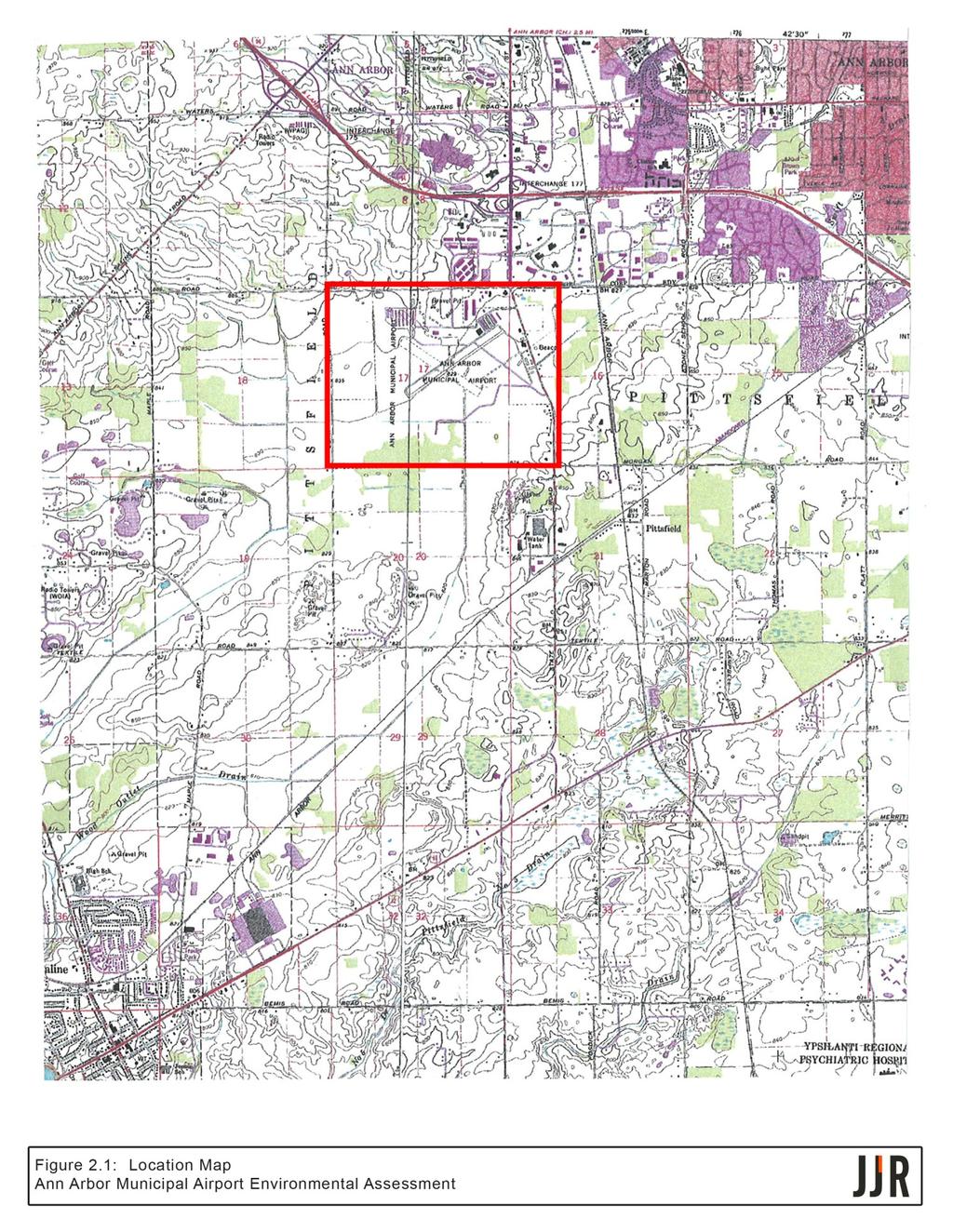
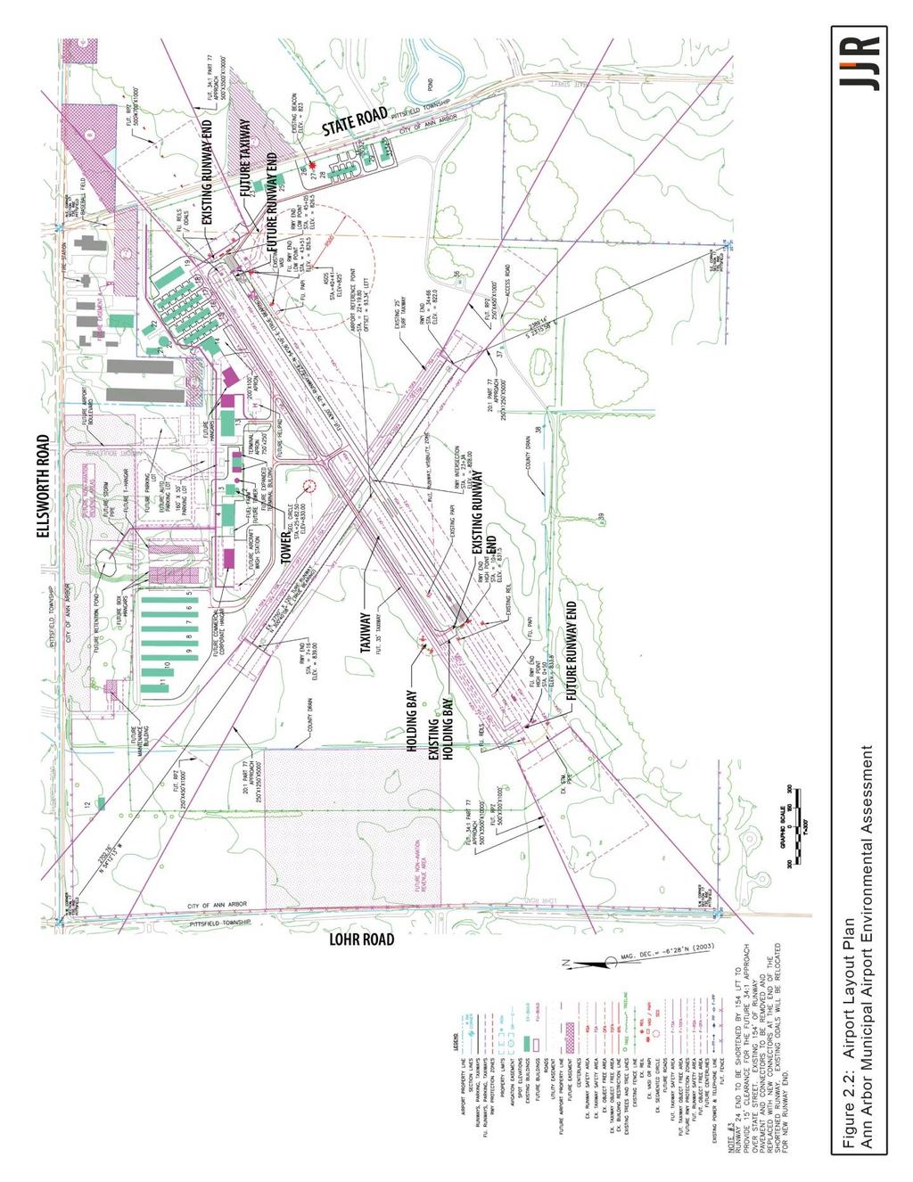
6 Section 2. Purpose and Need 2.1 PROJECT LOCATION AND DESCRIPTION Note: The following information contains a large number of aviation-related acronyms. A glossary with definitions is included in Section 10 of this document. Ann Arbor Municipal Airport (ARB) is a public-use, general aviation airport located in Washtenaw County, Michigan. The airport is located in Pittsfield Township and consists of approximately 837 acres. ARB is generally bound by Ellsworth Road to the north, State Road to the east, and Lohr Road to the west (Figure 2-1). ARB is in close proximity to state highways including US-23, M-14, US-12, and I-94. Direct access to the airport is from Ellsworth and State Roads. The closest public-use airport is Willow Run Airport in Ypsilanti, which is approximately 12 miles to the east (approximately a 20 minute drive by automobile). The southeastern region of Michigan has a high level of commerce, and high levels of commercial, corporate, and general aviation air traffic. The City of Ann Arbor owns and operates ARB. The city is responsible for contracting with the Fixed Base Operators (FBO), which are Solo Aviation, Ann Arbor Aviation Center, and Bijan Air. ARB s operating budget is an enterprise fund comprised solely of revenue generated by airport operations. The primary runway, Runway 6/24, is 3,505-feet long by 75-feet wide and is oriented in a northeast/southwest direction. ARB has 22 permanent aviation service buildings, including the administration building, the FBOs, maintenance facilities, conventional box hangars, a privately owned hangar, and the FAA Air Traffic Control Tower (ATCT). The airport also provides 150 T-hangar spaces in an additional 13 T-hangar structures. The current FAA-approved Airport Layout Plan (ALP) was updated in 2008 (Figure 2-2), and it incorporates the future development proposed in the Airport Capital Improvement Plan for ARB. The proposed improvements from the ALP that are documented in this EA include: Shift and extend existing Runway 6/24, resulting in a runway that would be 4,300-feet long by 75-feet wide. Shift and extend the parallel taxiway to coincide with the revised Runway 6/24. Provide a new taxiway connector to the extended Runway 6 end. Provide a new taxiway connector and holding bay to the shifted Runway 24 end. Ann Arbor Municipal Airport Environmental Assessment DRAFT Purpose and Need February 2010 Page 2-1


7 Ann Arbor Municipal Airport Environmental Assessment DRAFT February 2010 Purpose and Need Page 2-2


8 Ann Arbor Municipal Airport Environmental Assessment DRAFT Purpose and Need February 2010 Page 2-3
9 2.2 PURPOSE AND NEED The purpose of the proposed improvements at ARB is to provide facilities that more effectively and efficiently accommodate the critical aircraft that presently use the airport, as well as to enhance the operational safety of the airport. The critical aircraft is defined by the FAA as the most demanding aircraft-type that performs a minimum of 500 annual operations at a particular airport. In cases where the critical aircraft weigh less than 60,000 lbs, a classification of aircraft is used rather than a specific individual aircraft model. A recent Airport User Survey has confirmed that the critical aircraft classification for ARB is B-II Small Aircraft (MDOT, 2009). Aircrafts in this category have runway approach speeds between 91 and 120 knots, wingspans between 49- and 79-feet, and maximum certificated takeoff weights of 12,500 lbs or less. A representative aircraft of this classification is the Beechcraft King Air 200, a twin-engine turboprop aircraft that typically seats people, including the flight crew. As stated in FAA Advisory Circular 150/5325-4B, The design objective for the main primary runway is to provide a runway length for all airplanes that will regularly use it without causing operational weight restrictions. Airplanes that are classified within an airport s critical aircraft classification are considered by the FAA to be the regular use aircrafts of the primary runway. Development of the primary runway at ARB to the recommended length of 4,300-feet would allow the majority of B-II Small classification aircraft to operate at their optimum capabilities (without weight restrictions). Interstate commerce into and out of a community can be negatively impacted if business aircraft are forced to operate with load restrictions (i.e. reductions in passengers, cargo, and fuel associated with aircraft range) due to lack of suitable runway length. An origin-destination analysis was conducted on Instrument Flight Rules (IFR) flight plan records associated with ARB as part of the user survey process. Although the data analyzed did not include records of all operations conducted at ARB, it did confirm that there are a significant number of operations between ARB and distant locations throughout the country. Flight operations were verified between ARB and at least 31 other states (approximately 63 percent of the continental US). Also, approximately 67 percent of the IFR flight plan records examined were between ARB and out-of-state locations. These factors are strong indicators of corporate flight activity associated with interstate commerce, as opposed to local pleasure flying by general aviation pilots. The large number of states that were linked to ARB is also a strong indicator of use of the airport by many corporations, as opposed to a single or few corporate users. Some of the larger corporations that were confirmed by the user survey as being users of ARB are Synergy International, Wells Fargo, Polaris Industries, Bombardier Aerospace, Avis Industrial Corporation, Thumb Energy, NetJets, and AvFuel. NetJets provides on-demand air charter service and corporate aircraft fractional ownership opportunities to a large number of businesses located throughout the country. AvFuel Corporation, a nationwide supplier of Ann Arbor Municipal Airport Environmental Assessment DRAFT Purpose and Need February 2010 Page 2-4
10 aviation fuels and aviation support services, is headquartered in Ann Arbor and bases their Cessna 560 Excel Jet at ARB. The City of Ann Arbor proposes to extend the existing 3,505-foot primary runway to 4,300-feet in total length in order to more effectively accommodate the critical aircraft that currently use the airport. The runway extension would enhance interstate commerce associated with business aviation, and the other proposed modifications would enhance the operational safety of ARB. The objectives of the proposed project are to: Enhance interstate commerce by providing sufficient runway length to allow the majority of critical aircraft to operate without weight restrictions. Enhance operational safety by improving the FAA ATCT line-of-sight issues. Enhance operational safety in low-visibility conditions by providing a clear 34:1 approach surface to Runway 24, over State Road. Reduce the occurrence of runway overrun incidents by small category A-I aircraft (local objective). Relocate and potentially upgrade the Runway 24 Approach Light System Safety Enhancement The proposed 150-foot shift of the Runway 24 threshold to the west would enhance the safety of ground operations by taxiing aircraft. Currently, a hangar structure blocks the line-of-sight from the FAA ATCT to a portion of the parallel taxiway at the east end of the runway, including most of the taxiway hold area for departing aircrafts. While this situation is not considered hazardous, the proposed shift would enhance operational safety, and possibly prevent a runway incursion, by expanding the view of the hold area and parallel taxiway to ATCT personnel. The proposed shift of the Runway 24 threshold would also allow for a clear 34:1 approach surface to the east end of the runway (the current approach surface is the steeper 20:1). By keeping obstructions below the flatter 34:1 approach surface, an additional margin of safety is provided between approaching aircraft and any ground-based obstacles. This is particularly beneficial when aircraft are operating in low-visibility conditions. Provision of a clear 34:1 approach surface would also potentially allow visibility minimums to the Instrument Approach Procedure to Runway 24 to be lowered to 3/4 of a mile, as opposed to the current 1-mile visibility minimum. This would enhance the all-weather capability of the airport (and also interstate commerce) by allowing aircraft to continue to access the airport when weather conditions resulted in visibility dropping below the current 1-mile minimum. Due to the proposed relocation of the Runway 24 threshold, it is also proposed that the existing runway approach light system be relocated accordingly. The airport currently uses an Omni- Directional Approach Lighting System (ODALS) to identify the approach end of Runway 24. The sequentially-flashing strobe lights assist pilots in identifying the runway threshold location and runway centerline alignment in low-visibility conditions. Since the FAA no longer installs ODALS, the current approach light system would potentially be upgraded and replaced with the newer Medium Intensity Approach Lighting System with Sequenced Flashers (MALSF) as part Ann Arbor Municipal Airport Environmental Assessment DRAFT Purpose and Need February 2010 Page 2-5
11 of the relocation. The MALSF would serve the same function as the ODALS, and is structurally very similar Role of the Airport ARB is a public-use facility that serves the local community by supporting economic development and public services. The following businesses and organizations are located at and operate from the airport and employ staff that supports the operations of the airport: Two fixed-wing FBOs; A helicopter FBO; Three national rental car agencies; Two flying clubs; Four flight schools and pilot training centers; FAA ATCT; and, Air taxi, aircraft sales, aviation insurance and aviation fueling businesses. ARB serves the Ann Arbor medical and biomedical industries with professional air ambulance services, transporting patients, human organs, radio isotopes, and other biomedical products and services. Community pilots and aircraft owners are members of nonprofit organizations providing no charge charitable gifts of flight time to citizens in need. Some of these organizations include Wings of Mercy, Angel Flight, and Dreams and Wings. Wings of Mercy has documented 292 fights into or out of ARB since 1992 including 51 flights in ARB is included in the FAA s National Plan of Integrated Airport Systems (NPIAS) as a general aviation airport. Not all public-use airports are included in this nationwide airport system plan. Inclusion in the NPIAS signifies that the FAA considers this airport an important part of the nation s air transportation system, and it makes ARB eligible to receive federal grants as part of the FAA s Airport Improvement Program. ARB is also included in MDOT s Michigan Airport System Plan (MASP) (MDOT, 2008). The MASP presents the results of an airport system planning process that has been aligned with the goals and objectives of MDOT s State Long Range Plan. The MASP supports programming decisions and is useful in evaluating programming actions related to airport system and airport facility deficiencies. As part of the MASP development, each of Michigan s public-use airports were assigned to one of three tiers based on their contribution to the state system goals. Tier 1 airports respond to essential/critical airport system goals. These airports should be developed to their full and appropriate level. Tier 2 airports complement the essential/critical airport system and/or respond to local community needs. Focus at these airports should be on maintaining infrastructure with a lesser emphasis on facility expansion. Tier 3 airports duplicate services provided by other airports and/or respond to specific needs of individuals and small business. Ann Arbor Municipal Airport Environmental Assessment DRAFT Purpose and Need February 2010 Page 2-6
12 The MASP identifies ARB as a Tier 1 airport, with a current MASP classification of B-II. Basic standard developmental items for B-II category airports, as outlined in Table 40 of the MASP, are a paved primary runway of 4,300-feet in length by 75-feet wide, a paved parallel taxiway, appropriate runway lighting and visual aids, a runway approach protection plan, basic pilot and aircraft services, all-weather access, year-round access, and landside access. Although it is not a requirement, MDOT encourages all of Michigan s Tier 1 airport sponsors to consider development of their airports to comply with the basic development standards outlined in the MASP. ARB currently meets all MASP basic development standards for category B-II airports, with the exception of runway length. The current primary runway is only 3,505-feet in length by 75-feet wide. An extension of the primary runway to 4,300-feet in length would result in the airport meeting all state-recommended standards for B-II category airports Aircraft Operations and Runway Length Recommendations The Airport Reference Code (ARC) is a coding system developed by the FAA to correlate airport design criteria with the operational and physical characteristics of the airplane types that regularly use a particular airport. The critical aircraft, or grouping of aircraft, are generally the largest, most demanding types that conduct at least 500 operations per year at the airport. The ARC for each particular airport is determined based on two characteristics of the critical aircraft: the approach speed to the runway and the wingspan of the aircraft. The first component, designated by letter A through E, is the critical aircraft s Approach Category. This is determined by the approach speed to the runway: Category A: Approach speed less than 91 knots. Category B: Approach speed 91 knots or more, but less than 121 knots. Category C: Approach speed 121 knots or more, but less than 141 knots. Category D: Approach speed 141 knots or more, but less than 166 knots. Category E: Approach speed 166 knots or more. The second component, designated by Roman numeral I through VI, is the critical aircraft s Design Group. This is determined by the wingspan of the aircraft: Group I: Wingspan less than 49-feet. Group II: Wingspan 49-feet or more, but less than 79-feet. Group III: Wingspan 79-feet or more, but less than 118-feet. Group IV: Wingspan 118-feet or more, but less than 171-feet. Group V: Wingspan 171-feet or more, but less than 214-feet. Group VI: Wingspan 214-feet or more, but less than 261-feet. The FAA has also established categories for aircraft based on their certificated Maximum Takeoff Weights (MTOW), which are determined by each specific aircraft s manufacturer. Small Aircraft are those with MTOWs of 12,500 lbs. or less. Large Aircraft are those with MTOWs greater than 12,500 lbs. Ann Arbor Municipal Airport Environmental Assessment DRAFT Purpose and Need February 2010 Page 2-7
13 As previously mentioned, the airport user survey confirmed that the current critical aircraft category (and ARC) for ARB is B-II Small Aircraft. Based on the findings of the user survey analysis, the primary runway length recommendations by MDOT and FAA are as follows: MDOT Source: Michigan Airport System Plan (MASP 2008) Table 40 (statewide standard for all ARC B-II airports) 4,300-feet FAA Source: FAA Advisory Circular 150/5325-4B, Runway Length Requirements for Airport Design Figure 2-2 (airport-specific standard for ARB) 4,200-feet* * Note: The FAA runway length recommendation was obtained from Figure 2-2 in Advisory Circular 150/5325-4B. The following specifics for ARB were used in the determination: Airport Elevation: 839-feet above mean sea level Temperature: 83 degrees F mean daily maximum temp, hottest month of year (July) The FAA recommended runway length of 4,200-feet at ARB was obtained by calculation from FAA Advisory Circular 150/5325-4B, Runway Length Requirements for Airport Design, a publication that is used nationally by the agency. The resulting recommended runway lengths are airport-specific, and can vary by hundreds of-feet from site to site, depending on the specific airport elevations and mean daily maximum temperatures used in the calculations. The MDOT recommendation of 4,300-feet is a statewide standard for all airports in the state with category B-II critical aircraft classifications. Since airport elevations and mean maximum temperatures do not vary significantly from airport to airport in Michigan, as opposed to many other states, MDOT uses a single runway length recommendation for all airports of the same critical aircraft classification. The existing ARC shown on the current ALP for the airport is category B-II. This classification has been confirmed correct by the recent airport user survey. Even if the proposed extension to 4,300-feet is constructed, the ALP shows that the future ARC for the airport will remain category B-II Airport Operational Forecasts Year 2007 was the onset year of planning activities associated with the potential extension of Runway 6/24, and the year in which the airport manager and FBOs were requested to collect based and itinerant aircraft operational data for the purpose of determining project justification. In order to maintain consistency, FlightAware operational records from target year 2007 were also examined during the user survey analytical process. Actual total operations for year 2009 were recently published (January 2010) by the FAA for airports with ATCT. From the user survey operational data year 2007 through the most recent operational data year 2009, total annual operations at ARB have decreased approximately 21.8% Ann Arbor Municipal Airport Environmental Assessment DRAFT Purpose and Need February 2010 Page 2-8
14 (from 72,853 actual in 2007 to 57,004 actual in 2009). Since the operational totals were obtained from actual ATCT records, rather than estimates, they are considered very accurate. By applying the 21.8% decrease in total annual operations at ARB from 2007 to 2009 to the user survey results, a very accurate estimate can be obtained for the current level of operations by B- II category critical aircraft. The user survey report documents a total of 750 actual annual operations by B-II category critical aircraft from survey data year A 21.8% decrease in this number is still well above the FAA s substantial use threshold of 500. Therefore, even with the current decrease in annual operations due to the economic recession, there is still justification at the present time for the runway extension. The FAA s Terminal Area Forecast (TAF) shows year 2009 to be a low-point in total annual operations at ARB. The TAF projects total annual operations to continually increase every single year, from year 2010 through year Since the estimated 586 annual operations by B- II category aircraft in year 2009 confirm present justification for the runway extension, the continual increase in operations that are forecasted by the TAF confirm that justification for the runway extension is substantiated through year The following actual and forecasted Total Operations at ARB, from year 2000 through year 2030, are from the FAA data sources listed below. The Estimated Category B-II Operations for each year have been calculated based on the percentage of actual B-II operations to actual total operations in survey data year Ann Arbor Municipal Airport Environmental Assessment DRAFT Purpose and Need February 2010 Page 2-9
15 Table 2-1 Actual and Forecasted Total Operations at ARB Year Total Operations Estimated Category B-II Operations ,342 * 1, ,321 * 1, ,414 * ,051 * ,516 * ,940 * ,785 * ,853 * 750*** ,910 * ,004 * ,986 ** ,514 ** ,073 ** ,639 ** ,212 ** ,791 ** ,376 ** ,968 ** ,567 ** ,173 ** ,786 ** ,405 ** ,032 ** ,666 ** ,307 ** ,956 ** ,613 ** ,277 ** ,948 ** ,627 ** ,314 ** 714 * = Actual Total Operations from FAA ATCT records ** = Forecasted Total Operations from FAA TAF *** = Actual (from User Survey) Forecasts from the MDOT MASP also project increasing total operations at ARB from years 2010 through The MDOT forecasts, which are independent of the FAA forecasts, further substantiate the mid-term and long-term FAA projections of a rebound in activity at ARB to near survey year 2007 operational levels. Ann Arbor Municipal Airport Environmental Assessment DRAFT Purpose and Need February 2010 Page 2-10
16 AvFuel Corporation, which bases a B-II Large category Citation 560 Excel jet at ARB, has confirmed in writing that their operations at ARB increased from 211 actual operations in 2007 to 223 actual operations in Their Chief Pilot has also submitted written documentation that forecasts their future operational levels potentially increasing to 350 to 450 operations per year at ARB. The FAA TAF forecast, MDOT MASP forecast, and AvFuel s operational forecast all provide support to the fact that survey year 2007 operational data that was analyzed in the user survey process is a very pertinent representation of estimated future operational levels at ARB Surrounding Land Uses ARB is bordered by Ellsworth Road to the north, Lohr Road to the west, and State Road to the east. The primary runway is situated in a northeast/southwest direction. Residential, business, industrial, recreational, agricultural, and forested areas are located adjacent to the airport, and efforts were made during the analysis of alternatives to minimize impacts to these resources. Residential properties are located along Lohr Road and business properties are located along State and Ellsworth Roads. A perennial stream crosses through the airport property and flows to the south connecting to a county drain (Wood Outlet). A portion of the stream near the southwest end of the runway is enclosed in a concrete culvert Other Considerations Aircraft performance information and runway length requirements for each airplane are contained in the individual airplane flight operating manual. As quoted from FAA Advisory Circular 150/5325-4B, Paragraph 206, This information is provided to assist the airplane operator in determining the runway length necessary to operate safely. Performance information from those manuals was selectively grouped and used to develop the runway length curves in Figures 2-1 and 2-2. The major parameters utilized for the development of these curves were the takeoff and landing distances for Figure 2-1 and the takeoff, landing, and accelerate-stop distances for Figure 2-2. As stated earlier in this section, Figure 2-2 of the Advisory Circular was used to determine the FAA-recommended runway length for ARB. The accelerate-stop distance concept referred to above is an important operating consideration. In this concept, the pilot not only considers the amount of runway needed for takeoff, but also the amount of runway needed to abort the takeoff while on the takeoff roll and bring the aircraft to a stop. In situations where pilots detect a problem with the aircraft while on the takeoff roll, they are forced to continue the takeoff and contend with the problem in the air if there is not enough runway remaining to bring the aircraft to a stop. By having enough remaining runway to safely abort a takeoff and stop the aircraft while still on the ground, a pilot would be able to avoid a potentially hazardous situation of taking to the air with a mechanically-deficient aircraft. A local objective is to reduce the occurrence of runway overrun incidents. While overrun incidents are not officially recognized by the FAA or MDOT as justification for extending runways, there is merit to this local objective. The 11 overrun incident reports that were analyzed showed that most runway overruns at ARB involved small single-engine category A-I aircraft. These types of incidents often involve student pilots or low-time, relatively Ann Arbor Municipal Airport Environmental Assessment DRAFT Purpose and Need February 2010 Page 2-11
17 inexperienced pilots. There is no evidence in the incident reports that any of the aircraft which overran the end of the existing 3,505-foot runway exceeded the limits of the 300-foot long turf Runway Safety Area. Therefore, in each of these cases, the proposed 4,300-foot long runway would have provided sufficient length for the small category A-I aircraft to safely come to a stop while still on the runway pavement, without running off the runway end. The considerations mentioned above do not imply that the existing 3,505-foot runway is unsafe in any regard. Accelerate-stop distance requirements can be accommodated on the existing runway if pilots of critical category aircraft operate at reduced load capacities. In the cases of the previous runway overrun incidents, the turf Runway Safety Areas to the existing runway performed as designed and provided a clear area for the overrunning aircraft to come to a stop. There were no reports of personal injuries, although there were reports of aircraft damage in several of the incidents Summary The proposed shift and extension of primary Runway 6/24 at ARB would provide a runway configuration that more effectively accommodates the critical aircraft that presently use the facility. The proposed project would satisfy the FAA design objective of providing sufficient runway length to allow airplanes that regularly use it to operate without weight restrictions. The proposed project would also result in ARB achieving full compliance with all MDOT basic developmental standards outlined in the MASP 2008 for category B-II airports. In particular, the proposed project would provide the following benefits: Enhance business aviation and interstate commerce by providing sufficient runway length to allow the majority of category B-II Small critical aircraft that currently use ARB to operate without load restrictions (i.e. reduction in passengers, cargo, and fuel associated with aircraft range). Enhance the safety of ground operations, and lessen the chances of a runway incursion, by expanding the view of the parallel taxiway and aircraft hold area to ATCT personnel. Improve the all-weather capability of ARB and enhance operational safety in lowvisibility conditions by providing a clear 34:1 approach surface to Runway 24. Address the local objective of decreasing the number of runway overruns by small category A-I aircraft by providing approximately 800-feet of additional runway pavement. Ann Arbor Municipal Airport Environmental Assessment DRAFT Purpose and Need February 2010 Page 2-12
18 Airport User Survey Supplemental Report
19
20
21
22
23
24
25
26
27
28
DRAFT Environmental Assessment for Ann Arbor Municipal Airport Ann Arbor, Michigan
 DRAFT Environmental Assessment for Ann Arbor Municipal Airport Ann Arbor, Michigan Prepared for: City of Ann Arbor Michigan Department of Transportation - Office of Aeronautics and Federal Aviation Administration
MEETING MINUTES Page 1 of 5
 Page 1 of 5 50178.000 May 26, 2009 PROJECT PROJECT NO. MEETING DATE ISSUE DATE Citizens Advisory Committee Meeting MEETING LOCATION MEETING PURPOSE Amy Eckland ISSUED BY SIGNATURE PARTICIPANT See attached
APPENDIX X: RUNWAY LENGTH ANALYSIS
 APPENDIX X: RUNWAY LENGTH ANALYSIS Purpose For this Airport Master Plan study, the FAA has requested a runway length analysis to be completed to current FAA AC 150/5325-4B, Runway Length Requirements for
Lake Tahoe Airport Master Plan Public Meeting March 16, 2015
 Lake Tahoe Airport Master Plan Public Meeting March 16, 2015 What is an Airport Master Plan? a comprehensive study of an airport [that] usually describes the short, medium, and long term development plans
DRAFT FINAL REPORT AIRPORT MASTER PLAN. Rifle Garfield County Airport Revised May 15, 2014
 DRAFT FINAL REPORT AIRPORT MASTER PLAN Rifle Garfield County Airport Revised May 15, 2014 As required by Paragraph 425.B(4) of FAA Order 5100.38C, Airport Improvement Program (AIP) Handbook: The preparation
According to FAA Advisory Circular 150/5060-5, Airport Capacity and Delay, the elements that affect airfield capacity include:
 4.1 INTRODUCTION The previous chapters have described the existing facilities and provided planning guidelines as well as a forecast of demand for aviation activity at North Perry Airport. The demand/capacity
MEETING SUMMARY Page 1 of 4
 MEETING SUMMARY www.jjr-us.com Page 1 of 4 Ann Arbor Municipal Airport 50178.000 July 20, 2009 September 8, 2009 PROJECT PROJECT NO. MEETING DATE ISSUE DATE Ann Arbor Municipal Airport Citizens Advisory
Runway Length Analysis Prescott Municipal Airport
 APPENDIX 2 Runway Length Analysis Prescott Municipal Airport May 11, 2009 Version 2 (draft) Table of Contents Introduction... 1-1 Section 1 Purpose & Need... 1-2 Section 2 Design Standards...1-3 Section
Draft Concept Alternatives Analysis for the Inaugural Airport Program September 2005
 Section 10 Preferred Inaugural Airport Concept 10.0 Introduction The Preferred Inaugural Airport Concept for SSA was developed by adding the preferred support/ancillary facilities selected in Section 9
Airport Master Plan for Montgomery-Gibbs Executive Airport PAC Meeting #3
 Airport Master Plan for Montgomery-Gibbs Executive Airport PAC Meeting #3 Agenda > Introductions > Public Meetings Overview > Working Paper 3 - Facility Requirements > Working Paper 4 - Environmental Baseline
FACILITY REQUIREMENTS SUMMARY OF KEY ISSUES OVERVIEW
 FACILITY REQUIREMENTS SUMMARY OF KEY ISSUES OVERVIEW This summary is intended to provide a brief overview of the key issues associated with conformance to FAA standards at Methow Valley State Airport.
Lake Tahoe Airport Master Plan
 Lake Tahoe Airport Master Plan City Council Briefing October 20, 2015 What is an Airport Master Plan? a comprehensive study of an airport [that] usually describes the short, medium, and long term development
Merritt Island Airport
 TABLE OF CONTENTS CHAPTER 1 INTRODUCTION... 1-1 INTRODUCTION AND PROJECT OVERVIEW... 1-1 General Guidelines... 1-1 Prior Planning Documentation... 1-2 Key Issues... 1-2 Goals and Objectives... 1-2 Regulatory
Airport Master Plan for. Brown Field Municipal Airport PAC Meeting #3
 Airport Master Plan for Brown Field Municipal Airport PAC Meeting #3 Public Meeting #1 > 8/24/17 from 5:30 to 8:00 pm > 41 attendees signed-in > Comments: > EAA area > Environmental constraints > Focus
CHAPTER 1 EXECUTIVE SUMMARY
 CHAPTER 1 EXECUTIVE SUMMARY 1 1 EXECUTIVE SUMMARY INTRODUCTION William R. Fairchild International Airport (CLM) is located approximately three miles west of the city of Port Angeles, Washington. The airport
AIRPORT MASTER PLAN. Newport State Airport. Draft. (Colonel Robert F. Wood Airpark) THE Louis Berger Group, INC. Prepared for: Prepared by:
 THE Louis Berger Group, INC. Prepared for: Prepared by:") Draft AIRPORT MASTER PLAN Newport State Airport () Prepared for: 2000 Post Road Warwick, Rhode Island 02886-1533 THE Louis Berger Group, INC. 20 Corporate Woods Boulevard Albany, New York 12211-2370 Prepared
Draft AIRPORT MASTER PLAN Newport State Airport () Prepared for: 2000 Post Road Warwick, Rhode Island 02886-1533 THE Louis Berger Group, INC. 20 Corporate Woods Boulevard Albany, New York 12211-2370 Prepared
Executive Summary. MASTER PLAN UPDATE Fort Collins-Loveland Municipal Airport
 Executive Summary MASTER PLAN UPDATE Fort Collins-Loveland Municipal Airport As a general aviation and commercial service airport, Fort Collins- Loveland Municipal Airport serves as an important niche
1.0 Project Background Mission Statement and Goals Objectives of this Sustainable Master Plan
 TABLE OF CONTENTS CHAPTER 1 INTRODUCTION 10 Project Background 1-1 11 Mission Statement and Goals 1-1 12 Objectives of this Sustainable Master Plan 1-2 CHAPTER 2 INVENTORY 20 Airport Background 2-1 201
CHAPTER 1 BACKGROUND AND PROPOSED ACTION
 CHAPTER 1 BACKGROUND AND PROPOSED ACTION 1.0 INTRODUCTION An Environmental Assessment (EA) evaluates the effects of a proposed Federal action on the surrounding environment and is prepared in compliance
STUDY OVERVIEW MASTER PLAN GOALS AND OBJECTIVES
 INTRODUCTION An Airport Master Plan provides an evalua on of the airport s avia on demand and an overview of the systema c airport development that will best meet those demands. The Master Plan establishes
1.1.3 Taxiways. Figure 1-15: Taxiway Data. DRAFT Inventory TYPICAL PAVEMENT CROSS-SECTION LIGHTING TYPE LENGTH (FEET) WIDTH (FEET) LIGHTING CONDITION
 WIDTH (FEET) LIGHTING CONDITION") 1.1.3 Taxiways EWN has an extensive network of taxiways and taxilanes connecting the terminal, air cargo, and general aviation areas with the runways as listed in Figure 1-15. A 50-foot wide parallel taxiway
1.1.3 Taxiways EWN has an extensive network of taxiways and taxilanes connecting the terminal, air cargo, and general aviation areas with the runways as listed in Figure 1-15. A 50-foot wide parallel taxiway
Table of Contents. Overview Objectives Key Issues Process...1-3
 Table of Contents Chapter One Introduction Overview...1-1 Objectives...1-1 Key Issues...1-2 Process...1-3 Chapter Two Inventory of Existing Conditions Airport Setting...2-1 Locale...2-1 Airport Surroundings...2-5
Airport Master Plan Update June 15, 2017
 Airport Master Plan Update June 15, 2017 www.harveyfield.com The Master Plan is a 20-year plan to understand the needs of current and future users of the Airport. This is important to ensure that safe
Airport Master Plan Update June 15, 2017
 Airport Master Plan Update June 15, 2017 www.harveyfield.com The Master Plan is a 20-year plan to understand the needs of current and future users of the Airport. This is important to ensure that safe
Yolo County Airport. ALP Narrative Report. April Prepared by Mead & Hunt, Inc. for the County of Yolo, California
 Yolo County Airport ALP Narrative Report April 2016 Prepared by Mead & Hunt, Inc. for the County of Yolo, California Yolo County Airport ALP Narrative Report Prepared for the County of Yolo Mindi Nunes,
Airport Master Plan Update
 Duttchessss Countty Airrporrtt Masstterr Plan Updatte Airport Master Plan Update Final Report Dutchess County Airport Town of Wappingers, New York C&S Engineers, Inc. 499 Col. Eileen Collins Blvd. Syracuse,
JOSLIN FIELD, MAGIC VALLEY REGIONAL AIRPORT DECEMBER 2012
 1. Introduction The Federal Aviation Administration (FAA) recommends that airport master plans be updated every 5 years or as necessary to keep them current. The Master Plan for Joslin Field, Magic Valley
FORT LAUDERDALE-HOLLYWOOD INTERNATIONAL AIRPORT ENVIRONMENTAL IMPACT STATEMENT DRAFT
 D.3 RUNWAY LENGTH ANALYSIS Appendix D Purpose and Need THIS PAGE INTENTIONALLY LEFT BLANK Appendix D Purpose and Need APPENDIX D.3 AIRFIELD GEOMETRIC REQUIREMENTS This information provided in this appendix
Chapter Six ALP Drawings. Tacoma Narrows Airport. Master Plan Update
 Chapter Six ALP Drawings Master Plan Update The master planning process for the (Airport) has evolved through efforts in the previous chapters to analyze future aviation demand, establish airside and landside
Tallahassee International Airport Master Plan. Technical Advisory Committee Meeting #2 October 19, 2016
 Tallahassee International Airport Master Plan Technical Advisory Committee Meeting #2 October 19, 2016 Agenda Welcome / Introductions Master Plan Process and Project Status Forecast of Aviation Demand
AIRSIDE CAPACITY AND FACILITY REQUIREMENTS
 AIRSIDE CAPACITY AND FACILITY REQUIREMENTS This Section investigates the capacity of the airport, its ability to meet current demand, and the facilities required to meet forecasted needs as established
2015 PURDUE ROAD SCHOOL March 11, 2015
 2015 PURDUE ROAD SCHOOL March 11, 2015 Runway Protection Zone (RPZ) Definition It is a trapezoidal shape formed off the end of a runway and its geometry it a function of the airport s aircraft approach
Chapter 4.0 Alternatives Analysis
 Chapter 4.0 Alternatives Analysis Chapter 1 accumulated the baseline of existing airport data, Chapter 2 presented the outlook for the future in terms of operational activity, Chapter 3 defined the facilities
Dr. Antonio A. Trani Professor of Civil Engineering Virginia Polytechnic Institute and State University. Spring 2015 Blacksburg, Virginia
 CEE 4674 Airport Planning and Design Runway Length Calculations Addendum 1 Dr. Antonio A. Trani Professor of Civil Engineering Virginia Polytechnic Institute and State University Spring 2015 Blacksburg,
ERIE INTERNATIONAL AIRPORT MASTER PLAN TABLE OF CONTENTS
 EXECUTIVE SUMMARY ERIE INTERNATIONAL AIRPORT MASTER PLAN TABLE OF CONTENTS PAGE NO. CHAPTER 1-INTRODUCTION... 1-1 1.01 General...1-1 1.02 Purpose and Scope of Study...1-1 1.03 The Planning Process...1-2
PLU Airport Master Plan. Master Plan Advisory Committee (MPAC) Meeting #4 March 19, 2018
 Meeting #4 March 19, 2018") PLU Airport Master Plan Master Plan Advisory Committee (MPAC) Meeting #4 March 19, 2018 Meeting Agenda 1. Master Plan Status [5 Minutes] 2. Preferred Forecasts [15 Minutes] 3. Runway Length Options [45
PLU Airport Master Plan Master Plan Advisory Committee (MPAC) Meeting #4 March 19, 2018 Meeting Agenda 1. Master Plan Status [5 Minutes] 2. Preferred Forecasts [15 Minutes] 3. Runway Length Options [45
Runway Safety Margin Enhancement Project. Matt Kulhanek Director Facilities Management
 Runway Safety Margin Enhancement Project Ann Arbor Municipal Airport Matt Kulhanek Director Facilities Management 1 Agenda Background Environmental Assessment Study Airport Improvement Process Airport
Draft Concept Alternatives Analysis for the Inaugural Airport Program September 2005
 Draft Concept Alternatives Analysis for the Inaugural Airport Program September 2005 Section 3 - Refinement of the Ultimate Airfield Concept Using the Base Concept identified in Section 2, IDOT re-examined
Document prepared by MnDOT Office of Aeronautics and HNTB Corporation. MINNESOTA GO STATE AVIATION SYSTEM PLAN
 LAST UPDATE JULY 2013 Acknowledgements The preparation of this document was financed in part by a grant from the Federal Aviation Administration (Project No: 3-27-0000-07-10), with the financial support
Agenda: SASP SAC Meeting 3
 Agenda: SASP SAC Meeting 3 Date: 04/12/18 Public Involvement Plan Update Defining the System Recommended Classifications Discussion Break Review current system Outreach what we heard Proposed changes Classification
B GEORGIA INFRASTRUCTURE REPORT CARD AVIATION RECOMMENDATIONS DEFINITION OF THE ISSUE. Plan and Fund for the Future:
 2014 GEORGIA INFRASTRUCTURE REPORT CARD B + RECOMMENDATIONS Plan and Fund for the Future: While the system continues to enjoy excess capacity and increased accessibility it still needs continued focus
Chapter 8.0 Implementation Plan
 Chapter 8.0 Implementation Plan 8.1 Introduction This chapter is the culmination of the analytical work accomplished in the previous chapters. The result is a prioritized list of the essential projects.
Appendix C AIRPORT LAYOUT PLANS
 Appendix C AIRPORT LAYOUT PLANS Appendix C AIRPORT LAYOUT PLANS Airport Master Plan Santa Barbara Airport As part of this Airport Master Plan, the Federal Aviation Administration (FAA) requires the development
The purpose of this Demand/Capacity. The airfield configuration for SPG. Methods for determining airport AIRPORT DEMAND CAPACITY. Runway Configuration
 Chapter 4 Page 65 AIRPORT DEMAND CAPACITY The purpose of this Demand/Capacity Analysis is to examine the capability of the Albert Whitted Airport (SPG) to meet the needs of its users. In doing so, this
Westover Metropolitan Airport Master Plan Update
 Westover Metropolitan Airport Master Plan Update June 2008 INTRODUCTION Westover Metropolitan Airport (CEF) comprises the civilian portion of a joint-use facility located in Chicopee, Massachusetts. The
Prepared By: Mead & Hunt, Inc Port Lansing Road Lansing, MI 48906
 Master Plan The preparation of this document was financed in part through a planning grant from the Federal Aviation Administration (FAA) as provided under Section 505 of the Airport and Airway Improvement
Chapter 1 Introduction and Project Overview
 Chapter 1 Introduction and Project Overview Kittitas County in cooperation with the Federal Aviation Administration (FAA) is updating the Airport Master Plan for Bowers Field Airport (FAA airport identifier
Punta Gorda Airport Master Plan Update
 Punta Gorda Airport Master Plan Update Draft Executive Summary Prepared for: The Charlotte County Airport Authority January 2018 Charlotte County Airport Authority James Herston, Chair Robert D. Hancik,
Airport Master Plan. Brookings Regional Airport. Runway Runway 17-35
 Runway 17-35 Airport Master Plan Runway 12-30 Brookings Regional Airport Table of Contents Table of Contents Chapter 1: Master Plan Goals... 1-1 1.1. Introduction... 1 1.2. Objective 1 Identify improvements
Dr. Antonio A. Trani Professor of Civil Engineering Virginia Polytechnic Institute and State University. January 27, 2009 Blacksburg, Virginia
 Dr. Antonio A. Trani Professor of Civil Engineering Virginia Polytechnic Institute and State University January 27, 2009 Blacksburg, Virginia 1 Runway Design Assumptions (FAA 150/5325-4b) Applicable to
PULLMAN-MOSCOW REGIONAL AIRPORT Runway Realignment Project
 PULLMAN-MOSCOW REGIONAL AIRPORT Runway Realignment Project GENERAL AIRPORT INFORMATION AIRPORT USERS Airport ownership: Public, owned by the Pullman-Moscow Regional Airport Board Year opened: February
Why are the underground fuel tanks being removed and replaced with above ground tanks?
 AIRPORT/CITIZEN FAQ This list of Frequently Asked Questions (FAQs) with responses are provided to share information related to airport topics with the Citizens of Georgetown. The questions / responses
Addendum - Airport Development Alternatives (Chapter 6)
") Bowers Field Addendum - Airport Development Alternatives (Chapter 6) This addendum to the Airport Development Alternatives chapter includes the preferred airside development alternative and the preliminary
Bowers Field Addendum - Airport Development Alternatives (Chapter 6) This addendum to the Airport Development Alternatives chapter includes the preferred airside development alternative and the preliminary
Appendix D Project Newsletters. Tacoma Narrows Airport. Master Plan Update
 Appendix D Project Newsletters Tacoma Narrows Airport Master Plan Update This appendix contains the newsletters distributed throughout the project. These newsletters provided updates and information on
Update on the Aspen/Pitkin County Airport Improvements
 Update on the Aspen/Pitkin County Airport Improvements and EA Process Public Information Meeting September 10, 2015 Meeting Objectives Explain what has changed since we had our last meeting and how it
MASTER PLAN CONCEPT 1 DRAFT
 The Airport Master Plan Update for Dallas Executive Airport has included the development of aviation demand forecasts, an assessment of future facility needs, and the evaluation of airport development
Safety, Infrastructure, and Tenant Improvement Project. Public Hearing Informational Brochure February 26, 2013
 New York State Department of Transportation Safety, Infrastructure, and Tenant Improvement Project Public Hearing Informational Brochure February 26, 2013 This DEIS/Draft EA evaluates the potential impacts
TABLE OF CONTENTS. General Study Objectives Public Involvement Issues to Be Resolved
 TABLE OF CONTENTS Description Page Number LIST OF ACRONYMS... a CHAPTER ONE INTRODUCTION General... 1-1 Study Objectives... 1-1 Public Involvement... 1-2 Issues to Be Resolved... 1-2 CHAPTER TWO EXISTING
Appendix 6.1: Hazard Worksheet
 Appendix 6.1: Appendix 6.1: Ref. Condition, real or potential; that can cause injury, illness, etc. This is a prerequisite for an Airfield Hazards 1. Taxiway Geometry Direct access to runway from ramp
CHAPTER FOUR AIRPORT ALTERNATIVES
 4.0 INTRODUCTION CHAPTER FOUR The goal of the master planning process is to provide the City of New Smyrna Beach with an assessment of the adequacy and capabilities of the Airport as well as to identify
FORECASTING FUTURE ACTIVITY
 EXECUTIVE SUMMARY The Eagle County Regional Airport (EGE) is known as a gateway into the heart of the Colorado Rocky Mountains, providing access to some of the nation s top ski resort towns (Vail, Beaver
CHAPTER 3 ALTERNATIVES CONSIDERED
 CHAPTER 3 ALTERNATIVES CONSIDERED 3.0 ALTERNATIVES The 2010 Stevensville Airport Master Plan contained five (5) airside development options designed to meet projected demands. Each of the options from
Chapter 2 FINDINGS & CONCLUSIONS
 Chapter 2 FINDINGS & CONCLUSIONS 2.01 GENERAL Dutchess County acquired the airport facility in 1947 by deed from the War Assets Administration. Following the acquisition, several individuals who pursued
CHAPTER 1: INTRODUCTION
 CHAPTER 1: INTRODUCTION Purpose and Scope The information presented in this report represents the study findings for the 2016 Ronan Airport Master Plan prepared for the City of Ronan and Lake County, the
APPENDIX B: NPIAS CANDIDATE AIRPORT ANALYSIS
 APPENDIX B: NPIAS CANDIDATE AIRPORT ANALYSIS The National Plan of Integrated Airport Systems (NPIAS) is the Federal Aviation Administration s (FAA) national airport plan. The NPIAS includes nearly 3,500
STUDY WORK GROUP MEETING No. 3. November 29, 2016
 STUDY WORK GROUP MEETING No. 3 November 29, 2016 Agenda Welcome and introductions Update project schedule Brief overview of previous SWG meeting Update on aviation forecasts Introduction to airfield demand/capacity
Flying Cloud Airport (FCM) Zoning Process: Informing a Mn/DOT Path Forward
 Zoning Process: Informing a Mn/DOT Path Forward") : Informing a Mn/DOT Path Forward A Review of the Flying Cloud Airport (FCM) Joint Airport Zoning Board (JAZB) Process and the Draft Airport Zoning Ordinance B A RPZ RPZ A B C Zone Chad E. Leqve Director
: Informing a Mn/DOT Path Forward A Review of the Flying Cloud Airport (FCM) Joint Airport Zoning Board (JAZB) Process and the Draft Airport Zoning Ordinance B A RPZ RPZ A B C Zone Chad E. Leqve Director
Dallas Executive Airport
 648 DECLARED DISTANCE OPTION 1a DISPLACE 31 THRESHOLD BY 97 Considers RSA Limiting Factor No runway extensions 13 31 TORA 6,451 6,451 TODA 6,451 6,451 ASDA 5,958 6,451 LDA 5,958 6,354 Runway 17-35 (3,8
APPENDIX H 2022 BASELINE NOISE EXPOSURE CONTOUR
 APPENDIX H 2022 BASELINE NOISE EXPOSURE CONTOUR This appendix sets forth the detailed input data that was used to prepare noise exposure contours for 2022 Baseline conditions. H.1 DATA SOURCES AND ASSUMPTIONS
The offers operators increased capacity while taking advantage of existing airport infrastructure. aero quarterly qtr_03 10
 The 747 8 offers operators increased capacity while taking advantage of existing airport infrastructure. 14 aero quarterly qtr_03 10 Operating the 747 8 at Existing Airports Today s major airports are
Table of Contents. Master Plan March 2014 TOC i Spokane International Airport
 Table of Contents Page Chapter 1 Inventory 1. Introduction... 1 1 1.1 Community Profile... 1 2 1.1.1 Location and Setting... 1 1 1.1.2 Climate... 1 2 1.1.3 Socioeconomic Conditions... 1 5 1.1.4 Area Land
General Aviation Master Plan Update
 Peter O. Knight Airport Public Meeting #2 Peter O. Knight Airport Agenda Welcome and Introductions HCAA System of Airports Purpose of Public Meetings Master Plan Status Update Next Steps Q & A 2 Our System
Dallas Executive Airport Town Hall Meeting April 3, 2014
 Dallas Executive Airport Town Hall Meeting April 3, 2014 Background 1,040 acre general aviation facility owned and operated by the City of Dallas 150 based aircraft including business jets and helicopters,
DRAFT MASTER PLAN UPDATE
 DRAFT MASTER PLAN UPDATE CHAPTER VI: AIRPORT LAYOUT PLAN NARRATIVE DRAFT REPORT APRIL 2017 PREPARED BY: Table of Contents WESTCHESTER COUNTY AIRPORT 6 AIRPORT LAYOUT PLAN NARRATIVE REPORT... 6-1 6.1 AGIS
Hartford-Brainard Airport Potential Runway Closure White Paper
 Hartford-Brainard Airport Potential Runway 11-29 Closure White Paper June 2012 In recent years there has been discussion regarding the necessity of Runway 11-29 to the Hartford- Brainard Airport (HFD)
Draft Concept Alternatives Analysis for the Inaugural Airport Program September 2005
 Draft Concept Alternatives Analysis for the Inaugural Airport Program September 2005 Section 1 - Introduction This report describes the development and analysis of concept alternatives that would accommodate
New Opportunities PUBLIC WORKSHOP. Venice Municipal. Bringing g the pieces together
 Bringing g the PUBLIC WORKSHOP Venice Municipal Airport New Opportunities Presented for Venice City Council & Citizens of Venice September 25, 2009 Slide 1 Bringing g the Welcome & Introductions May 12th
15 Precision Approach Path Indicator 33 None RSA 150 feet wide by 300 feet long 150 feet wide by 300 feet long
 The first (AMP) was completed in 1984 and updated in 2000. The current FAA approved Airport Layout Plan (ALP) is dated November 9, 2001. The FAA suggests updating the AMP every five year in accordance
Alternatives. Introduction. Range of Alternatives
 Alternatives Introduction Federal environmental regulations concerning the environmental review process require that all reasonable alternatives, which might accomplish the objectives of a proposed project,
St. Paul Downtown Airport (STP)
") Reliever Airports: NOISE ABATEMENT PLAN St. Paul Downtown Airport (STP) 1 INTRODUCTION The noise abatement plan for the St. Paul Downtown Airport (STP) was prepared in recognition of the need to make the
Reliever Airports: NOISE ABATEMENT PLAN St. Paul Downtown Airport (STP) 1 INTRODUCTION The noise abatement plan for the St. Paul Downtown Airport (STP) was prepared in recognition of the need to make the
Milton. PeterPrinceAirportislocatedinSantaRosaCounty, approximatelythreemileseastofmilton.
 Milton GeneralAviationAirport PeterPrinceAirportislocatedinSantaRosaCounty, approximatelythreemileseastofmilton. Existing Facilities Peter Prince Airport is served by one runway, Runway 18/36, 3,700 feet
PLU Airport Master Plan Master Plan Advisory Committee (MPAC) Meeting #4 MASTER PLAN ADVISORY COMMITTEE (MPAC) - MEETING #4
 Meeting #4 MASTER PLAN ADVISORY COMMITTEE (MPAC) - MEETING #4") MASTER PLAN ADVISORY COMMITTEE (MPAC) - MEETING #4 MASTER PLAN ADVISORY COMMITTEE (MPAC) MEETING #4 AGENDA & ACTION ITEMS Date/Time: Location: Monday, March 19, 2018 from 1:30-3:30 p.m. Thun Field Airport
MASTER PLAN ADVISORY COMMITTEE (MPAC) - MEETING #4 MASTER PLAN ADVISORY COMMITTEE (MPAC) MEETING #4 AGENDA & ACTION ITEMS Date/Time: Location: Monday, March 19, 2018 from 1:30-3:30 p.m. Thun Field Airport
SECTION 5 ALTERNATIVE DEVELOPMENT CONCEPT ANALYSES
 SECTION 5 ALTERNATIVE DEVELOPMENT CONCEPT ANALYSES 5.1 INTRODUCTION This section investigates Airfield Development Alternatives, generalized Land Use Alternatives, and more detailed General Aviation Alternatives.
CATCODE ] CATCODE
![CATCODE ] CATCODE](/thumbs/82/85644630.jpg "CATCODE ] CATCODE") Runways. FAC: 1111 CATCODE: 111111 OPR: AFCEC/COS OCR: AF/A3O-A 1.1. Description. The runway is the paved surface provided for normal aircraft landings and take offs. Runways are classified as either Class
Runways. FAC: 1111 CATCODE: 111111 OPR: AFCEC/COS OCR: AF/A3O-A 1.1. Description. The runway is the paved surface provided for normal aircraft landings and take offs. Runways are classified as either Class
AIRPORT MASTER PLAN FOR. charles B. WHEELER DOWNTOWN AIRPORT KANSAS CITY, MISSOURI
 AIRPORT MASTER PLAN FOR charles B. WHEELER DOWNTOWN AIRPORT KANSAS CITY, MISSOURI Prepared For The City of Kansas City, Missouri By Coffman Associates, Inc. January 2004 "The contents of these documents
Ann Arbor Municipal Airport (ARB), Ann Arbor Michigan - Draft Environmental Assessment FAA Combined Comment Matrix --May thru October
, Ann Arbor Michigan - Draft Environmental Assessment FAA Combined Comment Matrix --May thru October") Comment Number Ann Arbor Municipal Airport (ARB), Ann Arbor Michigan - Draft Environmental Assessment FAA Combined Comment Matrix --May thru October 2016-- Page Number 1 1 title page n/a Section Number
Comment Number Ann Arbor Municipal Airport (ARB), Ann Arbor Michigan - Draft Environmental Assessment FAA Combined Comment Matrix --May thru October 2016-- Page Number 1 1 title page n/a Section Number
Vista Field Airport. Master Plan Update. February, Prepared for: Port of Kennewick One Clover Island Kennewick, Washington
 Vista Field Airport February, 2006 Prepared for: Port of Kennewick One Clover Island Kennewick, Washington 99336 Prepared by: J-U-B ENGINEERS, Inc. 2810 W. Clearwater Avenue, Suite 201 Kennewick, Washington
ACTION TRANSMITTAL
 Transportation Advisory Board of the Metropolitan Council of the Twin Cities ACTION TRANSMITTAL 2018-16 DATE: February 9, 2018 TO: Transportation Advisory Board FROM: Technical Advisory Committee PREPARED
Study Committee Meeting. September 2015
 W ki P T / Working Paper Two/ Study Committee Meeting September 2015 Agenda Introductions and Opening Comments Project Overview, Process, and Schedule Review Materials from Working Paper Two Comments,
Preliminary Findings of Proposed Alternative
 Preliminary Findings of Proposed Alternative The attached drawing provides a schematic layout of the proposed alternative that will be discussed on July 27, 2010. A full report will follow and should be
Burke Lakefront Airport (BKL) Master Plan Update
 Master Plan Update") Burke Lakefront Airport () Master Plan Update Public Workshop August 2, 2007 City of Cleveland Department of Port Control (DPC) City of Cleveland DPC Studies Currently In Progress Market Assessment & Feasibility
Burke Lakefront Airport () Master Plan Update Public Workshop August 2, 2007 City of Cleveland Department of Port Control (DPC) City of Cleveland DPC Studies Currently In Progress Market Assessment & Feasibility
Harvey Field Airport. Planning Advisory Committee & Public Open House. April 1, Comment Responses
 Harvey Field Airport Planning Advisory Committee & Public Open House April 1, 2015 Comment Responses In an effort to respond to comments received at both the Planning Advisory Committee (PAC) meeting and
CHAPTER 3 AIRPORT FACILITY REQUIREMENTS
 CHAPTER 3 AIRPORT FACILITY REQUIREMENTS 3.1 Introduction The existing runway and taxiway system at Skyhaven Airport provides more than adequate operational capacity to accommodate future peak hour and
Public Information Meeting. September 2015
 W ki P O & T / Working Papers One & Two/ Public Information Meeting September 2015 Agenda Introductions and Opening Comments Project Overview, Process, and Schedule Review Materials from Working Papers
The forecasts evaluated in this appendix are prepared for based aircraft, general aviation, military and overall activity.
 Chapter 3: Forecast Introduction Forecasting provides an airport with a general idea of the magnitude of growth, as well as fluctuations in activity anticipated, over a 20-year forecast period. Forecasting
STAFF REPORT. Airport Land Use Plan Consistency Review: Santa Barbara Airport Master Plan. MEETING DATE: November 19, 2015 AGENDA ITEM: 7D
 STAFF REPORT SUBJECT: Airport Land Use Plan Consistency Review: Santa Barbara Airport Master Plan MEETING DATE: AGENDA ITEM: 7D STAFF CONTACT: Peter Imhof, Andrew Orfila RECOMMENDATION: Adopt findings
TABLE OF CONTENTS. Washington Aviation System Plan Update July 2017 i
 TABLE OF CONTENTS Chapter 1 Overview... 1-1 1.1 Background... 1-1 1.2 Overview of 2015 WASP... 1-1 1.2.1 Aviation System Performance... 1-2 1.3 Prior WSDOT Aviation Planning Studies... 1-3 1.3.1 2009 Long-Term
Facility Requirements
 C H A P T E R T H R E E Facility Requirements 3.0 OVERVIEW Airport planning for facility requirements is based upon addressing any existing issues and accommodating the probable demand that may occur over
AVIATION. MichiganReportCard.com 5
 MichiganReportCard.com 5 GRADE C AVIATION OVERVIEW Michigan s 200+ airports bring $4.3 billion into the economy each year. The state s Tier 1 and Tier 2 airports were evaluated based on six key infrastructure
COMMERCIAL AND GENERAL AVIATION
 Existing Facilities Daytona Beach International Airport is served by a number of airside and landside facilities. The airport has three asphalt runways: Runway 07L/25R (10,500 feet long by 150 feet wide),