Airport Zoning Regulations
|
|
|
- Cory Washington
- 6 years ago
- Views:
Transcription
1

2 Airport Zoning Regulations Tampa International Airport Tampa Executive Airport Peter O. Knight Airport Plant City Airport Hillsborough County Aviation Authority June 1, 2017
3 TABLE OF CONTENTS Page Section 1 Title, Authority, Jurisdiction, Purpose and Findings Section 2 Definitions and Rules of Interpretation Section 3 Zones and Heights Requiring Permit, Airport Surfaces and Permit Procedures Section 4 Land Use Section 5 Existing Nonconforming Use Section 6 Administration, Enforcement and Remedies Section 7 Airport Board of Adjustment Section 8 Amendment Section 9 Conflict with Other Laws or Regulations Section 10 Severability Section 11 Repeal of Conflicting Provisions Section 12 Amendment of Laws Section 13 Effective Date ATTACHMENTS A1 A5 Airport Height Zoning Maps ATTACHMENT B Civilian Airport Imaginary Services Map ATTACHMENTS C1 C5 Airport Hazard Prevention Zones ATTACHMENTS D1 D5 UAS Operating Maps
4 SECTION 1 TITLE, AUTHORITY, JURISDICTION, PURPOSE AND FINDINGS 1.01 Title These Airport Height and Zoning Regulations (Regulations) will be known and cited as Airport Zoning Regulations for Tampa International Airport, Tampa Executive Airport, Peter O. Knight Airport and Plant City Airport (collectively the Airports ) Authority The Hillsborough County Aviation Authority is a public body corporate having jurisdiction over all public airports in Hillsborough County. The Authority consists of five members who constitute its Board. The Authority Board has the power to prepare, adopt and enforce these Regulations pursuant to Chapter 333, Florida Statutes and Section 6 (2)(x), Chapter , Laws of Florida, as amended, altered or modified from time to time, and such other authorities and provisions established in statutory or common law Jurisdiction These Regulations apply to all land within Hillsborough County, including land within the City of Tampa, the City of Temple Terrace and the City of Plant City as set forth herein (collectively the Affected Jurisdictions ) Findings The Authority Board hereby finds that: A. The creation or establishment of an airport obstruction hazardous to the operation of aircraft reduces the navigable airspace available to the region served by the Airports; B. It is necessary, in the interest of the public health, public safety and general welfare, to prevent the creation of airspace hazards and the use of land incompatible with airport operations; 3
5 C. The prevention of these hazards and incompatible land uses should be accomplished, to the extent legally possible, without compensation; D. Preventing the creation or establishment of hazards and incompatible land uses, as well as the elimination, removal, alteration or mitigation of hazards and incompatible land uses, are public purposes for which the Hillsborough County Aviation Authority may raise and expend public funds; E. Unmanned Aircraft Systems have the capability to be an Airspace Hazard when operated in close proximity to manned aircraft; and F. Manned aircraft are generaly prohibited by federal regulation from operating below 500 above ground level except when arriving or departing an Airport Purpose Based on the findings set forth in Section 1.04, the purposes of these Regulations are as follows: A. To promote the maximum safety of aircraft using the Airports and/or their respective airspace; B. To promote the maximum safety of persons and property located near the Airports; C. To promote the full utility of the Airports to ensure the maximum prosperity, welfare and convenience for the Affected Jurisdictions; D. To provide limits on the height of structures and objects of natural growth within the primary, horizontal, conical, approach, transitional and terminal instrument procedures surfaces, as defined herein, to ensure proper and sound development of the areas within these surfaces; E. To discourage new land uses, activities or construction incompatible with existing and planned airport operations or public health, safety and welfare; and F. To provide administrative procedures for the efficient and uniform review of land development proposals in the areas surrounding the Airports and/or their respective airspace. 4
6 SECTION 2 DEFINITIONS AND RULES OF INTERPRETATION 2.01 Definitions For the purpose of these Regulations, certain words and terms used herein are defined as follows: 1. Affected Jurisdictions. City of Tampa, City of Plant City, City of Temple Terrace and Hillsborough County. 2. Aeronautical Study. A Federal Aviation Administration study, conducted in accordance with standards of 14 C.F.R. part 77, subpart C, and Federal Aviation Administration policy and guidance, on the effect of proposed construction or alteration upon the operation of air navigation facilities and the safe and efficient use of navigable airspace. 3. Aircraft. Any fixed wing or rotorcraft device capable of manned atmospheric flight and requiring a paved, turf or water landing or take off area. 4. Airport. Any area of land or water designed and set aside for the landing and taking off of aircraft and utilized or to be utilized in the interest of the public for such purpose which, for the purposes of these Regulations, includes Tampa International Airport, Tampa Executive Airport, Peter O. Knight Airport or Plant City Airport. 5. Airport Business Day. 8:00 AM to 5:00 PM EST, Monday through Friday with the exception of Authority Holidays. 6. Airport Elevation. The highest point of an airport s usable landing area measured in feet above mean sea level. 7. Airport Board of Adjustment. The Authority Board, or such other board appointed by the Authority Board, acting pursuant to the terms and provisions of Chapter 333, Florida Statutes, as amended, altered or modified from time to time, created to carry out the obligations set for it in Section 7 of these Regulations. 8. Airport Hazard Prevention Zone. An area defined by the Airport to be given a priority of protection against obstructions and hazards that have a high probability to effect the safety and/or utility of the Airport based on existing and future technological advances to air navigation. 5
7 9. Airport Hazard Area. Any area of land or water upon which an airport hazard might be established. 10. Airport Hazard. Any obstruction to air navigation which affects the safe and efficient use of navigable airspace or the operation of planned or existing air navigation and communication facilities. 11. Airport Height Zone. Any area described herein or shown on the Airport Height Zoning Map indicating the height at which a proposal for development, construction, establishment, enlargement or substantial alteration or repair of a structure requires an airport height zoning review. 12. Airport Height Zoning Map. A map depicting the Airport Height Zones, attached hereto and incorporated herein as Attachments A1 A Airport Land Use Compatibility Zoning. Airport Zoning Regulations regulating the use of land adjacent to or in the immediate vicinity of any of the Airports. 14. Airport Layout Plan. A detailed, scaled engineering drawing, contained in an airport s master plan that provides a graphic representation of the existing and future development plan for the airport and demonstrates the preservation and continuity of safety, utility, and efficiency of the airport. 15. Airport Master Plan. A comprehensive plan of an airport which typically describes current and future plans for airport development designed to support existing and future aviation demand. 16. Airport Protection Zoning Regulations. Airport zoning regulations governing airport hazards. 17. Department. The Department of Transportation as created under Florida Statutes Landfill. Has the same meaning as provided in Florida Statutes Obstruction. Any existing or proposed structure, or object of natural growth that exceeds federal obstruction standards as contained in 14 CFR (formerly 77.23), (formerly 77.25), (formerly 77.28), and (formerly 77.29), as amended, altered or modified from time to time. Obstruction includes obstruction as defined by (12) in Florida Statues. 6
8 20. Airport Surface. Any surface established and described in these Regulations used to evaluate whether an application for an Airport height zoning permit or any existing or proposed structure or object of natural growth complies with federal obstruction standards as contained in 14 CFR (formerly 77.23), (formerly 77.25), (formerly 77.28), and (formerly 77.29), as amended, altered or modified from time to time; and terminal instrument procedures as contained in Federal Aviation Administration Order , entitled United States Standards for Terminal Instrument Procedures, as amended, altered or modified from time to time. 21. Airport Surveillance Radar (or ASR). A radar used for air traffic management. 22. Airport Users. Aircraft operators and owners who are tenants at any of the Airports or who have use agreements with the Authority for the operation of aircraft at these airports. 23. Airport Zoning Director. The Assistant Vice President of Planning and Development of the Authority, or designee, who shall be responsible for administering and enforcing these Regulations. 24. Airspace Hazard. Any structure, object of natural growth, or use of land which would exceed federal obstruction standards as contained in 14 CFR (formerly 77.23), (formerly 77.25), (formerly 77.28), and (formerly 77.29), as amended, altered or modified from time to time, and which affects the utility of the airport or obstructs the airspace required for the flight of aircraft in taking off, maneuvering or landing or which is otherwise hazardous to such taking off, maneuvering or landing of aircraft and for which no person has previously obtained a permit or variance pursuant to these Regulations. Includes Airport Hazard. 25. Authority. The Hillsborough County Aviation Authority. 26. Authority Board. The Board of the Hillsborough County Aviation Authority. 27. Avigation Easement. A conveyance of airspace over another property for use by the Airport. 28. County. Hillsborough County, Florida. 29. Day night Average Sound Level (DNL). The 24 hour average sound level, in decibels, for the period from midnight to midnight, computed with the addition of ten decibels to sound 7
9 levels for the periods between midnight and 7 a.m. and between 10 p.m. and midnight, local time. 30. Educational Facility. Any structure, land, or use thereof that includes a public or private kindergarten through twelfth grade school, charter school, magnet school, community college campus, college campus, or university campus. Educational Facilities do not include space used for educational purposes within a multitenant building, Flight Schools, Aircraft Mechanic Schools, Avionic Schools, or similar aviation related facilities. 31. Electromagnetic Interference (or EMI). Any frequency interference to air navigation, radio communication and/or surveillance facilities or equipment. 32. Existing Nonconforming Use. Any structure, object of natural growth or use of land that does not conform to the provisions of these Regulations or any amendments thereto as of the effective date of such Regulation or amendment. 33. Federal Aviation Administration (or FAA). The United States federal agency charged with regulating air commerce to promote its safety, encouraging and developing civil aviation, air traffic control and air navigation and promoting the development of a national system of airports. 34. Noise Contour Map. A scaled, geographic depiction representing average annual noise levels summarized by lines connecting points of equal noise exposure emanating from an airport s airfield. 35. Noise Exposure Map. An FAA approved scaled, geographic depiction of an airport, its noise contours and surrounding land use within the 65 DNL contour area developed in accordance with criteria specified by the FAA in 14 CFR Part 150, or equivalent standard, as amended, altered or modified from time to time. 36. Noise Level Reduction. The reduction of noise, measured in decibels, from the outdoor level to the indoor level through noise attenuation in design and construction. 37. Non Precision Instrument Runway. A runway having an existing instrument approach procedure utilizing air navigation facilities with only lateral guidance or area type navigation equipment, for which a straight in non precision instrument approach procedure has been approved or planned on an FAA planning document or approved airport layout plan. 8
10 38. Object of Natural Growth. Any organism of the plant kingdom, including a tree. 39. Person. Any individual, firm, co partnership, corporation, company, association, joint stock association or body politic, including any trustee, receiver, assignee or other similar representative thereof. 40. Political subdivision. Any county, municipality, town, village, or other subdivision or agency thereof, or any district or special district, port commission, port authority, or other such agency authorized to establish or operate airports in the state. 41. Public use Airport. An airport, publicly or privately owned, licensed by the State, which is open for use by the public. 42. Precision Instrument Runway. A runway having an existing instrument approach procedure utilizing air navigation facilities or an Instrument Landing System with lateral and vertical guidance or area type navigation equipment, for which a straight in precision instrument approach procedure has been approved or planned, and for which a precision approach is planned or indicated on an FAA planning document or approved airport layout plan. 43. Real Property. A lot, parcel, tract of land or water together with any structure, object of natural growth or natural feature located thereon. 44 Runway. A defined area on an airport prepared for landing and takeoff of Aircraft along its length. 45. Runway Protection Zone. Area at the end of a Runway designed to enhance the protection of people and property on the ground; the dimensions of which are based on aircraft category and visibility minimums defined in FAA Advisory Circular 150/ , entitled Airport Design, as amended, altered or modified from time to time. 46. Structure. Any permanent or temporary object constructed, erected, altered, or installed, including but not limited to buildings, antenna, towers, smoke stacks, utility or light poles, overhead transmission lines, advertising signs, billboards, poster panels, fences, construction cranes, derricks, draglines, boom equipped machinery, balloons, kites, watercraft and retaining walls. 9
11 47. Substantial Modification. Any repair, reconstruction, rehabilitation, or improvement of a structure when the actual cost of the repair, reconstruction, rehabilitation, or improvement of such structure equals or exceeds 50 percent of the market value of such structure. 48. Temporary Structure. Construction equipment or apparatus used for construction of a permanent structure or to repair, replace, or move equipment as needed, not to exceed a period of 18 months. 49. Terminal Instrument Procedures (or TERPS). Criteria for terminal instrument procedures for arriving and departing aircraft as established in FAA Order , entitled United States Standards for Terminal Instrument Procedures, as amended, altered or modified from time to time. 50. Unmanned Aircraft (UA). An aircraft that is operated without the possibility of direct human intervention from within or on the aircraft. 51. Unmanned Aircraft System (UAS). An ummanned aircraft and associated elements (including communication links and the components that control the unmanned aircraft) that are required for the pilot in command to operate the UA Abbreviations For the purpose of these Regulations, certain abbreviations will have the following meanings: A. AMSL. Above mean sea level. B. AGL. Above ground level. C. FDOT. Florida Department of Transportation. D. FAA. Federal Aviation Administration. E. FCC. Federal Communications Commission Rules of Interpretation Unless the natural construction of the wording indicates otherwise, all words used in the present tense include the future tense; all words in the plural number include the singular number; all words in the singular number include the plural number and all words of the masculine gender include correlative words of the feminine and neuter genders. Any reference herein to a rule, 10
12 statute, regulation or other legal requirement or form shall also include any modification, amendment, alteration or replacement thereof subsequent to the effective date hereof. SECTION 3 ZONES AND HEIGHTS REQUIRING PERMIT REVIEW, AIRPORT SURFACES AND PERMIT PROCEDURES 3.01 Zones and Heights Requiring Review for an Airport Height Zoning Permit In order to regulate the height of permanent and temporary structures and objects of natural growth, this Section establishes a review process for permitting requirements in certain zones based on height. These zones, and the heights established for each zone, provide for the independent review by the Authority of the height of land development proposals over which the Affected Jurisdictions may have jurisdiction to regulate, as well as objects of natural growth. No structure or object of natural growth that would exceed the height for the zone in which it is located or is proposed to be located may be developed, constructed, established, enlarged, substantially altered or repaired, approved for construction, issued a natural resources permit or building permit, or planted, allowed to grow or be replanted, unless either the Airport Zoning Director or his designee has reviewed the proposal in accordance with Sections 3.05 and 3.06 below and issued a notice of compliance or a height zoning permit and variance. The zones and heights are depicted on the Airport Height Zoning Map, attached hereto and incorporated herein as Attachments A1 A5, and are defined as follows: A. Zone A. That area within the County limits extending outward 20,000 feet from the ends and sides of each runway as depicted on the Airport Height Zoning Map as Zone A. The height for Zone A is that height as extended outward and upward from the nearest point of the nearest runway at a slope of 1 foot vertically to 100 feet horizontally outward to 20,000 feet, identified on the Height Zoning Map in AMSL increments or 200 feet AGL whichever is lowest. 11
13 B. Zone B. That area within the County limits outside of Zones A, C1, C2 and C3 as depicted on the Airport Height Zoning Map as Zone B. The height for Zone B is 200 feet above ground level. C. Zones C1, C2 and C3. That area surrounding Tampa International Airport that could potentially impact that Airport s terminal instrument procedures as depicted on the Airport Height Zoning Map as Zones C1, C2 and C3. The height for Zone C1 is 180 feet AMSL. The height for Zone C2 is 180 feet AMSL. The height for Zone C3 is 210 feet AMSL Airport Height Zoning Permit Application Procedure A request for an airport height zoning permit may be initiated by filing with the Airport Zoning Director a completed application for an airport height zoning permit, on a form prescribed by the Authority, including a copy of FAA Form , Notice of Proposed Construction or Alteration filed with the FAA, as required pursuant to 14 CFR (formerly 77.23) and 77.9 (formerly 77.13), as amended, altered or modified from time to time. Any request exceeding FAA Notice Criteria as determined under 14 CFR 77.9 (formerly 77.13) or the height limits depicted on the Height Zoning Map established under Section 3.01 and shown in Attachments A1 A5 must obtain a review by the Zoning Director or his designee. Request that exceed height requirements under Sections 3.05 and 3.06 of the Height Zoning Regulations or FAA Regulations 14 CFR (formerly 77.23) and/or (formerly 77.25) must seek a height zoning permit and variance. An FAA determination resulting from the submittal of a Notice of Proposed Construction or Alteration does not preclude the requirement to obtain an airport height zoning permit from the Authority. A separate application for an airport height zoning permit must be submitted for permanent or temporary derricks, draglines, cranes and other boom equipped machinery to be used during construction or installation at heights greater than the height of the proposed structure. Applications for an airport height zoning permit must be signed by the owner or an authorized agent of the owner. 12
14 3.03 Pre Application Conference Procedure Prior to the submittal of any application for an airport height zoning permit, a prospective applicant should request a pre application conference with the Airport Zoning Director or designee. The pre application conference is to advise the applicant of the information needed for submittal and the standards and other requirements so that issues can be identified and costly modifications avoided. Information provided as a result of the conference is for conceptual purposes only. This meeting is given solely as a means to assist the applicant, and does not take the place of the formal application review process Processing of Airport Height Zoning Permit Application A. Review of Height Zoning Permit An application for an airport height zoning permit for a permanent structure exceeding obstruction standards must contain: i) a copy of the final determination by the FAA of the applicant s Notice of Proposed Construction or Alteration and ii) a site survey, with an FAA accuracy code of 1A, which certifies the site coordinates and elevations with an accuracy of +/ 20 feet horizontal and +/ 3 feet vertical (all site coordinates must be based on North American Datum of 1983 and National Geodetic Vertical Datum of 1988, as may be amended, altered or modified from time to time). Additional information that may be required at the request of the Zoning Director or designee include: i) site plans; ii) elevation drawings; and iii) other data as may be necessary to enable the Airport Zoning Director or designee to determine whether or not the proposal will comply with these Regulations. Upon receipt of a completed application and copy of the final determination from the FAA, the Airport Zoning Director or designee will review the application for consistency with the height limits and screening criteria as set forth in Sections, 3.05, 3.06 and 3.07 herein. B. Review of Temporary Permits. Temporary structures will be evaluated in accordance with existing runway and airspace constraints as amended, altered or modified from time to time. Temporary structures exceeding height limits or obstruction standards as specified under Sections 3.05 or 3.06 may qualify for a 13
15 Temporary Permit as specified under Section Temporary structures that do not exceed 72 hours may be considered as an emergency use. Required documentation for a temporary permit will be in accordance with Section If the temporary structure exceeds TERPS standards it must have an FAA determination or an agreed upon operating procedure issued by the Authority before any permit can be approved. C. Determination. Within a period of 20 calendar days from receipt of a completed application and final determination by the FAA, the Airport Zoning Director will either approve or disapprove the application. The Airport Zoning Director may consider an application for an airport height zoning permit concurrently with the development plan approval consideration by the local government with jurisdiction. An incomplete application will be deemed abandoned 180 days after filing, unless pursued in good faith ( Abandonment Period ). The Airport Zoning Director may grant one extension of 180 days. The extension must be requested in writing prior to the expiration of the Abandonment Period and justifiable cause demonstrated by factual information supported by a sworn affidavit or other reliable information Airport Surfaces There are hereby created and established certain airport surfaces in order to evaluate whether any existing or proposed structure or object of natural growth complies with federal obstruction standards as contained in 14 CFR (formerly 77.23), (formerly 77.25), (formerly 77.28), and (formerly 77.29), as amended, altered or modified from time to time; Obstacle Clearance Requirements in accordance with AC 150/ Appendix 2, as amended, altered or modified from time to time: and terminal instrument procedures as contained in FAA Order , entitled United States Standards for Terminal Instrument Procedures, as amended, altered or modified from time to time. The airport surfaces are hereby specified for the most precise approach existing or planned for each runway and include all of the land lying beneath the airport surface, as applied to each airport. Except as otherwise provided in these Regulations, no application for an airport height zoning permit may be approved; no structure may be 14
16 developed, constructed, established, enlarged, substantially altered or repaired, approved for construction or issued a natural resources permit or building permit; and no object of natural growth may be planted, allowed to grow or be replanted, in any airport surface at a height above the height limit established herein for the airport surface in which the structure or object of natural growth is located or proposed to be located. Such height limits will be computed from mean sea level elevation, unless otherwise specified. The primary, horizontal, conical, approach and transitional airport surfaces are illustrated on the drawing of Civilian Airport Imaginary Surfaces incorporated herein as Attachment B and illustrated in FAA Order JO , entitled Procedures for Handling Airspace Matters, as amended, altered or modified from time to time, and are defined as follows: A. Primary Surface. That area longitudinally centered on a runway at grade and extending 200 feet beyond each end of that runway with a width as specified herein for each runway. The height limit for any structure or object of natural growth within the primary surface is the height of the nearest point on the runway centerline. The width of the primary surface for each runway is hereby established as follows: 1. Tampa International Airport a. Runway 19R 01L: 1,000 feet b. Runway 19L 01R: 1,000 feet c. Runway 10 28: 500 feet d. Future Runway 17 35: 1,000 feet 2. Tampa Executive Airport a. Runway 05 23: 1,000 feet b. Runway 18 36: 500 feet 3. Peter O. Knight Airport a. Runway 04 22: 500 feet b. Runway 18 36: 500 feet 4. Plant City Airport a. Runway 10 28: 500 feet 15
17 B. Horizontal Surface. That area surrounding each airport the outer boundary of which is constructed by swinging arcs of radii specified herein for each runway and connecting the adjacent arcs by lines tangent to those arcs. The radius of the arc specified for each end of a runway will have the same arithmetical value. That value will be the higher determined for either end of the runway. When a 5,000 foot arc is encompassed by tangents connecting two adjacent 10,000 foot arcs, the 5,000 foot arc will be disregarded on the construction of the perimeter of the horizontal surface. The height limit for any structure or object of natural growth within the horizontal surface is 150 feet above the airport elevation. The radius of each arc for each runway is hereby established as follows: 1. Tampa International Airport a. Runway 19R 01L: 10,000 feet b. Runway 19L 01R: 10,000 feet c. Runway 10 28: 10,000 feet d. Future Runway 17 35: 10,000 feet 2. Tampa Executive Airport a. Runway 05 23: 10,000 feet b. Runway 18 36: 5,000 feet 3. Peter O. Knight Airport a. Runway 04 22: 5,000 feet b. Runway 18 36: 5,000 feet 4. Plant City Airport a. Runway 10 28: 10,000 feet C. Conical Surface. That area extending outward from the periphery of the horizontal surface for a distance of 4,000 feet. The height limit for any structure or object of natural growth within the conical surface is 150 feet above the airport elevation at the inner boundary with the allowable height increasing 1 foot vertically for every 20 feet of horizontal distance. 16
18 D. Approach Surface. That area longitudinally centered on the extended centerline of a runway and extending outward from each end of each runway s primary surface. The inner width and horizontal length of the approach surface for each runway is hereby established as provided herein for each end of a runway based on the type of approach currently designated or planned for that runway in the future. 1. Inner Width of Approach Surface. The inner width of the approach surface for each runway is hereby established to be the same width as the primary surface. 2. Horizontal Length of Approach Surface. The horizontal length of the approach surface for each runway is hereby established as follows: a. Tampa International Airport (1) Runway 19R: 50,000 feet (2) Runway 19L: 50,000 feet (3) Runway 01R: 50,000 feet (4) Runway 01L: 50,000 feet (5) Future Runway 17: 50,000 feet (6) Future Runway 35: 50,000 feet (7) Runway 28: 10,000 feet (8) Runway 10: 10,000 feet b. Tampa Executive Airport (1) Runway 23: 50,000 feet (2) Runway 05: 10,000 feet (3) Runway 36: 5,000 feet (4) Runway 18: 5,000 feet c. Peter O. Knight Airport (1) Runway 04: 5,000 feet (2) Runway 22: 5,000 feet 17
19 (3) Runway 18: 5,000 feet (4) Runway 36: 5,000 feet d. Plant City Airport (1) Runway 10: 10,000 feet (2) Runway 28: 10,000 feet 3. Outer Width of Approach Surface. The outer width of the approach surface for each runway expands uniformly from the primary surface to a width as follows: a. Tampa International Airport (1) Runway 19R: 16,000 feet (2) Runway 19L: 16,000 feet (3) Runway 01R: 16,000 feet (4) Runway 01L: 16,000 feet (5) Future Runway 17: 16,000 feet (6) Future Runway 35: 16,000 feet (7) Runway 28: 3,500 feet (8) Runway 10: 3,500 feet b. Tampa Executive Airport (1) Runway 23: 16,000 feet (2) Runway 05: 3,500 feet (3) Runway 36: 1,250 feet (4) Runway 18: 2,000 feet c. Peter O. Knight Airport (1) Runway 04: 1,250 feet (2) Runway 22: 2,000 feet (3) Runway 18: 1,250 feet (4) Runway 36: 2,000 feet d. Plant City Airport (1) Runway 10: 3,500 feet (2) Runway 28: 3,500 feet 18
20 4. Height Limits of Approach Surface. The height limit for any structure or object of natural growth within the approach surface is the same as the runway end height at the inner edge and with the allowable height increasing with horizontal distance outward from the inner edge as follows: a. Tampa International Airport (1) The height limit within the approach surface increases 1 foot vertically for every 50 feet of horizontal distance for the first 10,000 feet and then 1 foot vertically for every 40 feet of horizontal distance for an additional 40,000 feet for the following runways: (a) Runway 19R (b) Runway 19L (c) Runway 01R (d) Runway 01L (e) Future Runway 17 (f) Future Runway 35 (2) The height limit within the approach surface for Runway 28 increases 1 foot vertically for every 34 feet of horizontal distance. (3) The height limit within the approach surface for Runway 10 increases 1 foot vertically for every 34 feet of horizontal distance. b. Tampa Executive Airport (1) The height limit within the approach surface for Runway 23 increases 1 foot vertically for every 50 feet of horizontal distance for the first 10,000 feet and then 1 foot vertically for every 40 feet of horizontal distance for an additional 40,000 feet. (2) The height limit within the approach surface for Runway 05 increases 1 foot vertically for every 34 feet of horizontal distance. (3) The height limit within the approach surface increases 1 foot vertically for every 20 feet of horizontal distance for the following runways: (a) Runway 36 19
21 (b) Runway 18 c. Peter O. Knight Airport. The height limit within the approach surface increases 1 foot vertically for every 20 feet of horizontal distance for the following runways: (1) Runway 04 (2) Runway 22 (3) Runway 18 (4) Runway 36 d. Plant City Airport. The height limit within the approach surface increases 1 foot vertically for every 34 feet of horizontal distance for the following runways: (1) Runway 10 (2) Runway 28 E. Transitional Surface. That area extending outward from the sides of the primary surface and approach surface connecting to the horizontal surface. The height limits for any structure or object of natural growth within the transitional surface is the same as the primary surface or approach surface at the boundary line where it adjoins and increases at a rate of 1 foot vertically for every 7 feet horizontally, with the horizontal distance measured at right angles to the runway centerline and extended centerline, until the height equals the height of the horizontal surface, conical surface or end of approach surface. F. Obstacle Clearance Surfaces Protection of approach and departure surfaces in accordance with runway end siting requirements as specified in AC 150/ Appendix 2, as amended, altered or modified from time to time. G. TERPS Surfaces. Those surfaces as defined by the FAA Order , entitled United States Standards for Terminal Instrument Procedure, as amended, altered or modified from time to time. Any structure or object of natural growth within the TERPS surfaces will be evaluated by the FAA and the Airport Zoning Director pursuant to FAA Order
22 H. One Engine Inoperative (OEI) Surfaces. The OEI surface will only be established at Tampa International Airport for Runways 01L, 01R, 19R, and 19L. The surface begins at the end of the Runway with an inner width of 600 feet and outer width of 6,000 feet. It extends outward 1 foot vertically for every 62.5 feet horizontal for a distance of 21,600 feet Objects Affecting Navigable Airspace Any existing or proposed structure or object of natural growth that exceeds the standards for identifying and evaluating aeronautical effect as defined in, FAA Order JO , entitled Procedures for Handling Airspace Matters, is presumed to be a hazard to air navigation unless an obstruction evaluation study determines otherwise. Any structure or object of natural growth in violation of these standards will be evaluated by the FAA and the Airport Zoning Director to determine if the structure has a substantial adverse effect on navigable airspace affecting airport operations Supportive Screening Criteria A. Antenna Installations. Antenna installations used to transmit over navigable airspace may produce a harmful electromagnetic interference (EMI) with navigation aids or radio communications of aircraft, airport or air traffic control facility. An antenna installation must comply with the permitting requirements of this Section unless the antenna is to be co located on an existing structure and: 1. The antenna does not increase the height of the existing structure; 2. The structure has a current no hazard determination on file with the FAA; and 3. The transmission of the antenna has been coordinated and approved by the Federal Communications Commission (FCC). B. Mitigation of EMI. Notwithstanding Section 3.07(A), if an antenna system operating in the designated frequency bands causes EMI, the Authority or FAA will contact the antenna s operator. The operator must mitigate the EMI in a timely manner, as recommended by the FAA in each particular case. The operator must eliminate harmful EMI either by adjusting operating parameters, or by ceasing transmissions, as may be required by the FCC or the 21
23 FAA. Failure to provide successful EMI mitigation techniques may result in referral to the FCC s Enforcement Bureau for possible enforcement action. C. Airport Surveillance Radar (ASR). Any structure or object of natural growth meeting the following criteria must be evaluated by the FAA for interference with the ASR: 1. Any structure within a 1,500 foot radius of the ASR facility; 2. Any structure, freestanding or guyed metal tower, above ground utility line, water tower, elevated highway, overpass or bridge within 1 mile of the ASR facility; 3. Any structure, except temporary construction equipment, beyond 1 mile of the ASR facility penetrating a.25 degree screening angle beginning at the elevation of the ASR feeder horn; or 4. Any temporary pivot or horizontal crane within a 2,500 foot radius of the ASR facility. If the FAA determines that such proposed structure or object of natural growth will adversely affect the utilization of the ASR, the Airport Zoning Director will not approve an application for an airport height zoning permit. If the FAA determines that such proposed structure or object of natural growth will not adversely affect the utilization of the ASR, the Airport Zoning Director may approve an application for an airport height zoning permit, if such structure or object of natural growth will not exceed the height limits established for the airport surfaces as set forth in Section 3.05 and the standards for navigable airspace referenced in Section 3.06 and will not otherwise constitute an airspace hazard. D. Airport Hazard Prevention Zones. Any permanent structure or object of natural growth exceeding the criteria established under Sections 3.05 and 3.06 within an Airport Hazard Prevention Zone, attached hereto and incorporated herein as Attachments C1 C5, would be considered an unfavorable obstruction and determined by the Airport Zoning Director or designee to be a potential hazard or have substantial adverse effect on navigable airspace affecting future Airport operations. Each Zone has a priority of importance assigned to assist in evaluating obstructions in accordance with provisions established under Sections 3.08 and The following zones represent varying levels of potential adverse risk or impact to Airport operations and each zone will be provided different 22
24 levels of scrutiny commensurate with that varying level of risk. Those zones and the priorities for evaluation are as follows: 1. Zone HP1 Permanent structures that fall within Zone HP1 would be given a priority 1 status which would be provided a heightened degree of scrutiny in order to insure that Zone HP1 is free of obstructions in accordance with Sections 3.05 and 3.06 to secure the existing and future utility of the Airport. The reason for the heightened degree of scrutiny is that obstructions within Zone HP1 have the ability to affect existing and future approach design capabilities resulting in a loss of utility to the Airport and an increasing risk to people and property on the ground. This area contains the runway protection zone and a portion of the approach and departure zones at critical stages of flight. Proposed obstructions within Zone HP1 are highly discouraged and would require the Authority to circulate the petition and recommendation to Airport users for comment prior to a variance hearing. Upon receipt of the petition the users will have up to 14 days to respond. 2. Zone HP2 Permanent structures that fall within Zone HP2 would be given a priority 2 status which would be provided a heightened degree of scrutiny in order to insure that Zone HP2 is free of obstructions in accordance with Sections 3.05 and 3.06 to secure the existing and future utility of the Airport. The reason for the heightened degree of scrutiny is that obstructions within Zone HP2 have the ability to affect existing and future approach design capabilities resulting in a loss of utility to the Airport. This area contains a portion of the approach and departure zones at critical stages of flight. Proposed obstructions within Zone HP2 are discouraged but may be considered for a variance after evaluating the potential impact to Airport utility and any safety critical impacts associated with or directly attributed by the proposed obstruction. The request may require the Authority to circulate the petition to Airport users at the discretion of the Airport Zoning Director or designee, in which case the Airport users have 14 days to respond. 3. Zone HP3 Permanent structures that fall within Zone HP3 would be given a priority 3 status which would be provided a heightened degree of scrutiny in order to insure 23
25 that Zone HP3 is free of obstructions in accordance with Sections 3.05 and 3.06 to secure the existing and future utility of the Airport. Obstructions within Zone HP3 should be evaluated based on the following criteria to be considered for a variance: i. A safety critical condition warrants approval. ii. An unnecessary financial hardship would result that may lead to abandonment of the project. iii. The proposed structure is fixed by function for public safety or aviation good. iv. There are no operational impacts that would affect the safety of aircraft operations. E. Shielding 1. Shielding is a method that may be used by the Zoning Director or his designee to determine if a structure or object of natural growth that exceeds obstruction standards, impacts aeronautical operations and procedures. a) Consideration. Shielding is one of many factors that must be considered in determining the physical effect a structure or object of natural growth may have upon aeronautical operations and procedures. Good judgment, in addition to the circumstances of location and flight activity, will be considered in determining whether proposed or existing structures or object of natural growth would be physically shielded. b) Principle. The principle in applying the shielding guidelines is whether the location and height of the structures or object of natural growth is such that aircraft, when operating with due regard for the shielding structure, would not collide with that structure. c) Limitations. Application of the shielding effect is limited to: i. The physical protection provided by existing natural terrain, topographic features, or surface structures or object of natural growth of equal or greater height than the structure under study; and 24
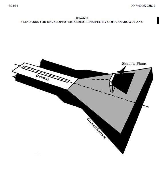
26 ii. The structure or object of natural growth providing the shielding protection is of a permanent nature and there are no plans on file with the FAA for the removal or alteration of the structure or object of natural growth. d) Guidelines. Any proposed construction of or alteration to an existing structure is normally considered to be physically shielded by one or more existing permanent structure(s), natural terrain, or topographic feature(s) of equal or greater height if the structure under consideration is located: i. Not more than 500 feet horizontal distance from the shielding structure(s) and in the congested area of a city, town, or settlement, provided the shielded structure is not located closer than the shielding structure(s) to any heliport or airport located within 5 miles of the structure. ii. iii. Such that there would be at least one such shielding structure situated on at least three sides of the shielded structure at a horizontal distance of not more than 500 feet. Within the lateral dimensions of any runway approach surface but would not exceed an overall height above the established airport elevation greater than that of the outer extremity of the approach surface, and located within, but would not penetrate, the shadow plane of the shielding structure. e) Considering shadow plane The term shadow plane means a surface originating at a horizontal line passing through the top of the shielding structure at right angles to a straight line extending from the top of the shielding structure to the end of the runway. The shadow plane has a width equal to the projection of the shielding structure's width onto a plane normal to the line extending from the top and center of the shielding structure to the midpoint of the runway end. The shadow plane extends horizontally outward away from the shielding structure until it intersects or 25
27 reaches the end of one of the imaginary approach area surfaces, see FIG FIG in accordance with FAA Order JO K CHG 1. f) FAA Flight Procedures, will make the final determination before applying shielding criteria for structures that penetrate precision approach surfaces. 26
28 27
29 28
30 29
31 30
32 3.08 Criteria for Reviewing Airport Height Zoning Permit Applications A. Approval. No application for an airport height zoning permit will be approved solely on the basis that the FAA has issued a determination of no hazard to air navigation under a valid aeronautical study. If the FAA has issued a determination that the proposed structure will not constitute an airspace hazard and the applicant has established by clear and convincing evidence provided to the Airport Zoning Director that the proposed structure or object of natural growth will not exceed the height limits established for the airport surfaces as set forth in Section 3.05 and the standards referenced in Section 3.06 and will not otherwise constitute an airspace hazard, or have an impact on airport operations, the Airport Zoning Director will approve an application for an airport height zoning permit. In the event of approval, the permit will be issued within 5 Airport Business Days. No airport zoning height permit will be issued after the expiration date indicated on the FAA s final determination. Each airport height zoning permit will specify an expiration date as a condition. Development authorized by the permit must commence prior to the permit s expiration date and must continue without interruption in good faith until development is complete; otherwise it shall lapse. After a permit has been issued, no change, modification, alteration or deviation may be made in the proposed structure or object of natural growth that would deviate from the terms or conditions of the permit without first obtaining a modification of the permit. A modification may be applied for in the same manner as the original permit. B. Disapproval. The Airport Zoning Director will not approve an application for an airport height zoning permit if: 1. The FAA has issued a determination that the proposed structure or object of natural growth would constitute an Airspace Hazard or 2. The Airport Zoning Director has determined that the proposed structure or object of natural growth would exceed the height limits established for the Airport Surfaces as set forth in Section 3.05 or the standards referenced in Section 3.06, unless a Variance has been granted by the Board of Adjustment. Notwithstanding the foregoing, the Airport Zoning Director may issue a temporary permit in accordance with Section 7.06 and Section 7.17 of these Regulations. Any decision of the 31
33 Airport Zoning Director disapproving an airport height zoning permit application may be appealed as prescribed in Section 7.05 herein. C. Extensions. If there are no changes being requested to the existing Height Zoning Permit the Airport Zoning Director or designee can issue a written extension of the Height Zoning Permit after reviewing the existing permit to confirm that no changes are being requested and that the original approval of all heights, locations, and conditions is still valid by an FAA approved extension letter or new FAA determination. A new Permit with an expiration date will be issued with a date not to exceed 18 months from the date of the expiration of the original Height Zoning Permit or based on the FAA s revised expiration date issued in the extension letter or new determination, whichever is shorter. The review process will take into account any changes to criteria that may have been amended, altered or modified since the original review. If there are any changes required to the original review the applicant will be required to file a new application and request a new FAA determination Hazard Marking and Lighting If a structure or object of natural growth is located within two nautical miles of an Airport or if recommended by the FAA, the Airport Zoning Director may require, as a condition of approval of an application for an airport height zoning permit, the applicant to install prior to the issuance of a certificate of occupancy, and to operate and maintain, at the applicant s own expense, such marking and/or lighting on the permitted structure as may be necessary to indicate to aircraft pilots the presence of the structure or object of natural growth. Such marking and lighting must conform to the specific standards in FAA Advisory Circular , entitled Obstruction Marking and Lighting, and Section , Florida Administrative Code, as may be amended, altered or modified from time to time Permit Required in Addition to Those Issued by Other Agencies A permit required by these Regulations is in addition to any other building, zoning, environmental or occupancy permits required by any other governmental agency or jurisdiction. 32
34 3.11 Rules of Interpretation A structure or object of natural growth located in more than one of the described Airport Height Zones or under an Airport Surfaces must comply with the most restrictive height limit or surface. In the event a conflict arises between an Airport Surface and the regulations as set forth in 14 CFR (formerly 77.23), (formerly 77.25), (formerly 77.28), and (formerly 77.29), as may be amended, altered or modified from time to time, and terminal instrument procedures as contained in FAA Order , entitled United States Standards for Terminal Instrument Procedures, as may be amended, altered or modified from time to time, the most restrictive regulation will prevail. SECTION 4 LAND USE 4.01 Land Use Compatibility Reviews The Airport Zoning Director will review and provide comments, as part of the development review process of the Affected Jurisdictions, on the following types of land uses or conditions in compliance with Chapter 333, Florida Statutes, as may be amended, altered or modified from time to time: A. Any facility that utilizes a smoke stack or steam vent greater than 24 inches in diameter that produces smoke or steam and which interferes with the vision of pilots or aircraft lift located within 10,000 feet of the nearest point of any runway used or planned to be used by turbojet, turboprop piston powered aircraft. B. Any facility that utilizes high energy or light beam devices, such as spot lights, strobe lights or laser lights, projected or directed in a plane greater than 45 degrees above the ground as measured from the light source, and for which such energy or light transmission is not fully contained within a structure or absorbing or masking vessel, 33
35 and that either misleads or obscures the vision of pilots or interferes with navigation signals or airfield lights of any airport. C. Any hazardous wildlife attractants (as defined in FAA Advisory Circular 150/ B) in the following areas: 1. Within 10,000 feet of the nearest point of any runway used or planned to be used by turbojet or turboprop aircraft; or 2. Within 5,000 feet of the nearest point of any runway used or planned to be used only by piston type aircraft. D. Any educational facility or residential construction in the following areas: 1. Where the Authority operating a public use airport has conducted a noise study in accordance with the provisions of 14 CFR Part 150, or where the Authority has established noise contours pursuant to another public study approved by the FAA, as may be amended, altered or modified from time to time. 2. Where a noise study has not been conducted for an Airport, any educational facility or residential construction within an area contiguous to the Airport measuring one half the length of the longest runway on either side of and at the end of each runway centerline. E. Any incompatible uses or substantial modification to existing incompatible uses, within the runway protection zone of an Airport, as defined by 14 CFR 151.9(b), as may be amended, altered or modified from time to time 4.02 Airport Compatibility Zoning The City of Tampa has established the MA P airport compatibility districts, the City of Plant City has established the MA P airport industrial district and Hillsborough County has established the SPI AP airport districts to limit the type, arrangement and intensity of uses of land within such zoning districts. The purposes of the MA P and SPI AP zoning districts are to minimize the adverse effects of aircraft operations on uses, real property, structures and occupants of areas likely to be affected and to enable the Airports to operate effectively and safely and in accordance with the provisions of each agency s comprehensive plan. The Airport Zoning Director will 34
36 oppose any variance or rezoning which could have an adverse effect upon the development or use of the Airports or which could diminish the protection and promotion of the public use of the Airports. The regulations of the MA P and SPI AP zoning districts, including all sub districts and sub areas of the zoning districts, as adopted by the City of Tampa, the City of Plant City and Hillsborough County are hereby supplemented by the following regulations: A. Development Review. All land development proposals within MA P and SPI AP zoning districts, including all sub districts and sub areas of the zoning districts, must be reviewed by the Airport Zoning Director for compatibility with the Airports. Land development proposals for the purposes of this subsection include but are not limited to applications for rezonings, special use permits, conditional use permits, variances, site development plans, commercial site plans, plats, large scale developments, development agreements, subdivisions, community development districts, developments of regional impact, land annexations or amendments thereto. Any comprehensive plan updates or amendments, community plans, land use map amendments and evaluation assessment report updates affecting the MA P and SPI AP zoning districts also must be reviewed by the Airport Zoning Director. B. Review Criteria. The following criteria will be considered, when relevant, by the Airport Zoning Director in reviewing land development proposals and providing the Airport Compatibility Determination as described below: 1. Public Safety. The Airport Zoning Director will consider the public s health and safety. In applying this criterion, the Airport Zoning Director will consider the uses listed in this subsection to be a special concern given the increased potential for significant harm. Those land uses not specifically listed in this subsection will be evaluated based on their similarity to the uses listed herein and to the extent to which they embody a similar degree of risk of harm. a. Educational facilities, excluding aviation school facilities; b. Hospitals and nursing homes, excluding clinics; c. Places of worship; d. Residential; 35
37 e. Assembly halls, meeting centers, training classrooms, theatres, and other similar land uses, which by their nature attract or encourage the gathering, assembly or concentration of people; f. Above ground storage, distribution or manufacture of flammable, explosive, toxic, radioactive, biohazardous or other hazardous materials; g. Land uses that produce smoke, steam, glint, glare or other interference with the vision of pilots; h. Digital billboards: and I. Wildlife preserves or habitats created for either aesthetics or mitigation. 2. Noise Exposure. The Airport Zoning Director will consider if the proposed development is located in the 65 average DNL contour (or future noise level prescribed by the FAA) as depicted in the Airport s noise exposure map in accordance with the provisions on 14 CFR Part 150 or equivalent standard (noise contour map contained in the Airport s current master plan). The average DNL is the standard metric for determining the cumulative exposure of individuals to noise based on the 24 hour average noise level, in decibels, for the period from midnight to midnight, obtained after the addition of 10 decibels to noise levels for the periods between midnight and 7 a.m. and between 10 p.m. and midnight, local time, as averaged over a span of one year. In evaluating this criterion, the Airport Zoning Director will use the information identifying land uses that are normally compatible or incompatible with various levels of noise exposure contained in Table 1 Land Use Compatibility with Yearly Day Night Average Sound Levels of 14 CFR Part 150 as may be amended, altered or modified from time to time. If more than one land use is proposed, evaluation of compatibility will be based on that use most adversely affected by noise. Those land uses not specifically listed in Table 1 will be evaluated based on their similarity to noise tolerance and compatibility with normal aircraft or airport operations as exhibited by the land uses which are listed in the Table. 36
38 C. Airport Compatibility Determination. Based on the review of the criteria in Section 4.02(B), the Airport Zoning Director will issue a determination within 10 Airport Business Days of receipt of the land development proposal as to whether the land use is: 1. Compatible without conditions. With the exception of height, the Airport Zoning Director will not oppose any land development proposal determined to be compatible with an Airport; 2. Not compatible. The Airport Zoning Director will oppose any land development proposal determined to be incompatible with an Airport; or 3. Compatible with conditions. The Airport Zoning Director or designee will not oppose any land development proposal determined to be compatible with an Airport subject to the conditions that the height is acceptable and a certain noise level reduction will be achieved through incorporation of noise attenuation into the design and construction of the proposed structure, or an avigation easement and/or release of liability signed by the property owner and tenant in a form acceptable to the Authority will be executed and recorded in the property records of the County, or both conditions. a. Noise Level Reduction Condition. A condition requiring noise level reduction must be achieved through incorporation of noise attenuation into the design and construction of the proposed structure by a combination of building design, choice of building materials and construction techniques in accordance with established architectural and acoustic principles. The noise level reduction requirements will apply to all occupied rooms having one or more exterior walls or ceilings, when furnished in accordance with the intended final usage of the room. The Airport Zoning Director may require certified professional documentation or other appropriate evidence to substantiate claims of noise level reduction performance. The local government granting final approval of the finished building construction may require, at the expense of the owner, field tests by a qualified acoustic consultant to verify the noise level reduction of the building. 37
39 b. Avigation Easement and/or Release of Liability Condition. A condition requiring execution and recording of an avigation easement and/or release of liability must be achieved before rezoning approval, release of a development site plan, recording of a final plat or issuance of a building permit or certificate of occupancy by the applicable local government with jurisdiction, as determined by the Airport Zoning Director Reckless Endangerment by UAS Anyone operating a UAS above 400 AGL or at any height above the runway protection zones depicted on Attachments D1 D5 is engaging in reckless endangerment unless the UAS operation is authorized by the FAA and the UAS is operated in acordance with all FAA rules, regulation guidance and advisory circulars. It shall be a violation of the Height Zoning Regulations for any person in the County to use land to operate a UAS above 400 AGL or to operate a UAS at a height above the runway protection zones depicted on Attachments D1 D5 unless the UAS operation is authorized by the FAA and the UAS is operated in acordance with all FAA rules, regulation guidance and advisory circulars. SECTION 5 EXISTING NONCONFORMING USE 5.01 Existing Nonconforming Use Any structure, object of natural growth or use of land existing before the effective date of the Height Zoning Regulation that made the use non conforming or April 1, 2010, whichever is later, which exceeds any height limit established herein or otherwise fails to comply with any provision of these Regulations, is hereby declared to be an existing nonconforming use and in violation of these Regulations. 38
40 5.02 Change of Existing Nonconforming Use No existing nonconforming use may be (1) enlarged, increased in height, expanded, replaced, substantially altered or repaired at a cost which exceeds 50 percent of the value of the existing nonconforming use within any 5 year period (2) rebuilt or (3) allowed to grow higher or to be replanted, unless the Airport Zoning Director has issued an airport height zoning permit or the Airport Board of Adjustment has issued a variance in conformance with these Regulations Continuance of Existing Nonconforming Uses A. Existing Nonconforming Uses. Except as provided in Sections 5.02, 5.04 or 5.05 herein, nothing in these Regulations will be construed to require removal, lowering, alteration, sound conditioning or other change to or interfere with a nonconforming use in existence before the effective date of the Height Zoning Regulation that made the use nonconforming or April 1, 2010 whichever is earlier. The continuation of any existing nonconforming use will be governed by the Regulations in effect on the date of the creation of the existing nonconforming use, except as provided in Sections 5.02, 5.04 or 5.05 herein. A property or structure loses its nonconforming use status if the property is abandoned for a period of more than 3 continuous years. An object of natural growth becomes non conforming on the date it exceeds any height limit established by the Regulations or otherwise fails to comply with the Regulations, or April 1, 2010 whichever is later. B. Existing Nonconforming Educational Facilities. Except as provided in Sections 5.04 or 5.05 herein, nothing in these Regulations will be construed to require removal, alteration, sound conditioning or other change to or interfere with the continued use, modification or adjacent expansion of any educational facility in existence on or before July 1, 1993, or be construed to prohibit the construction of any new educational facility for which a site has been determined as provided in former Section , Florida Statutes as of July 1,
41 5.04 Existing Nonconforming Use Declared an Airspace Hazard A. Declaration of Airspace Hazard. In the event the Airport Zoning Director determines an existing nonconforming use constitutes an airspace hazard, the Airport Zoning Director will petition the Airport Board of Adjustment, upon due notice to the owner of the existing nonconforming use or the real property on which it is located, to declare the existing nonconforming use to be an airspace hazard and to compel the owner to lower, remove, trim, reconstruct, equip or otherwise alter the existing nonconforming use to conform to these Regulations. Upon receipt of a petition to declare an existing nonconforming use to be an airspace hazard, the Airport Board of Adjustment will conduct a public hearing pursuant to these Regulations after due notice to the owner. At such hearing the property owner and any other affected person shall have an opportunity to be heard and to present evidence. If, after a public hearing, the Airport Board of Adjustment determines an existing nonconforming use constitutes an airspace hazard, the Airport Board of Adjustment will compel the owner, at the owner s own expense, to lower, remove, reconstruct, equip or otherwise alter the airspace hazard as necessary to conform to these Regulations. B. Failure to Remove Airspace Hazard. If the owner neglects or refuses to comply (or to promptly commence and diligently pursue compliance) with such order within 30 calendar days after notice thereof or such time set forth in the order, the Authority may proceed to lower, remove, reconstruct, equip or otherwise alter the airspace hazard and assess the cost and expense thereof on the airspace hazard or the real property whereon the airspace hazard is or was located. Unless such assessment is paid within 90 calendar days from the service of notice thereof upon the owner of the airspace hazard or the real property whereon the airspace hazard is or was located, the sum shall be a lien on said airspace hazard and real property, which will bear interest thereafter at the greater of: (i) the applicable Judgment interest rate as set by the Florida Chief Financial Officer.; or (ii) rate of six percent per annum until paid. Said lien will be collected in the same manner as taxes on real property are collected by the County, or at the option of the Authority said lien may be enforced in the manner provided for the enforcement of liens by Chapter 85, Florida Statutes. 40
42 5.05 Abandoned or Deteriorated Existing Nonconforming Use A. Declaration of Abandoned or Deteriorated Existing Nonconforming Use. In the event the Airport Zoning Director determines an existing nonconforming use is abandoned or more than 80 percent torn down, destroyed, deteriorated or decayed, no permit will be issued that would allow such existing nonconforming use to exceed the applicable height limit or otherwise deviate from these Regulations; and whether application is made for a permit under these Regulations or not, the Airport Zoning Director may petition the Airport Board of Adjustment, upon due notice to the owner of the existing nonconforming use or the owner of the real property on which it is located, to compel the owner to lower, remove, reconstruct, equip or otherwise alter the abandoned, destroyed, deteriorated or decayed nonconforming use as may be necessary to conform to these Regulations. Upon receipt of such petition, the Airport Board of Adjustment will conduct a public hearing pursuant to these Regulations after due notice to the owner. At such hearing the property owner and any other affected person shall have an opportunity to be heard and to present evidence. If, after a public hearing, the Airport Board of Adjustment determines the existing nonconforming use to be abandoned, or more than 80 percent torn down, destroyed, deteriorated or decayed, the Airport Board of Adjustment will compel the owner, at the owner s own expense, to lower, remove, reconstruct, equip or otherwise alter the existing nonconforming use as may be necessary to conform to these Regulations. B. Failure to Remove Abandoned or Deteriorated Existing Nonconforming Use. If the owner neglects or refuses to comply with such order within 30 calendar days after notice thereof, the Authority may proceed to lower, remove, reconstruct, equip or otherwise alter the structure or use and assess the cost and expense thereof on the structure or the real property whereon it is or was located. Unless such assessment is paid within 90 calendar days from the service of notice thereof upon the owner of the Structure or Real Property where the Structure is or was located, the sum will be a lien on said Structure and Real Property, which will bear interest thereafter at the greater of: (i) the applicable Judgment interest rate as set by the Florida Chief Financial Officer; or (ii) rate of six percent per annum 41
43 until paid. Said lien will be collected in the same manner as taxes on real property are collected by the County, or at the option of the Authority said lien may be enforced in the manner provided for the enforcement of liens by Chapter 85, Florida Statutes. Whenever the provisions of this Section are carried out, the nature and extent of abandonment, destruction, deterioration or decay will be fully and adequately documented and said documentation will be placed within the official records of the Airport Board of Adjustment Objects of Natural Growth (Including Trees) A. Priority. Object of natural growth trimming priority will be determined and evaluated based on the following areas of concern: 1. Approach Surfaces 2. Approach Transitional Surfaces 3. Transitional Surfaces 4. Horizontal Surface B. Benchmarking. Object of natural growth height will be benchmarked by stereo imagery taken on or before the following dates as applied to each of the Airports: 1. Tampa International Airport October of Tampa Executive Airport May of Peter O Knight Airport April of Plant City Airport April of 2014 C. Trimming and Removal. Whenever possible, the Airport Zoning Director will endeavor to negotiate with property owners to permit the Authority to trim or remove objects of natural growth that exceed the height limits contained herein. In the event negotiation is unsuccessful and the object of natural growth is an Airspace Hazard, the Airport Zoning Director will follow the procedure contained in Section 5.04 and elsewhere in these Regulations to eliminate the Airspace Hazard. 42
44 SECTION 6 ADMINISTRATION, ENFORCEMENT AND REMEDIES 6.01 Administration The provisions of these Regulations will be interpreted, administered and enforced by the Airport Zoning Director. The duties of the Airport Zoning Director will include that of hearing and deciding all permits and all other matters under these Regulations except any of the duties or powers herein delegated to the Airport Board of Adjustment. The Airport Zoning Director will coordinate the administration of these Regulations with the appropriate departments of the Affected Jurisdictions and FDOT. The Airport Zoning Director will transmit applications for action by the Airport Board of Adjustment in accordance with these Regulations Enforcement In the event of a violation of these Regulations or an order, ruling or permit issued hereunder, the Airport Zoning Director will provide a citation in writing to the owner of the real property on which the violation is located and/or the person perpetrating the violation. Such citation will be notice and will indicate the nature of the violation and order the owner or perpetrator to lower, remove, reconstruct, equip or otherwise alter the structure or object of natural growth or otherwise cease the violation in order to correct or abate the violation within a period of time set forth in the citation Remedies A. Penalty. Each violation of a regulation, order, ruling or permit issued hereunder constitutes a misdemeanor of the second degree punishable as provided in Florida Statutes. Each day a violation continues to exist will constitute a separate offense. Any person who violates, disobeys, omits, neglects or refuses to comply with, or who resists the enforcement of any of the provisions of these Regulations or an order, ruling or permit issued hereunder, upon conviction in the County court, will be fined not more than $ for each offense, or by 43
45 imprisonment in the County jail for not more than six months, or by both fine and imprisonment. B. Judicial Relief. In addition to the provisions of Section 6.03(A), the General Counsel or Assistant General Counsel of the Authority is hereby authorized to institute in any court of competent jurisdiction an action on behalf of the Authority to prevent, restrain, correct or abate any violation of these Regulations, or of any order or ruling made in connection with the administration or enforcement of these Regulations, and the court will adjudge to the Authority such relief, by way of injunction or otherwise, which may be mandatory or otherwise, as may be proper under all the facts and circumstances of the case in order to fully effectuate the purposes of these Regulations and any order or ruling made pursuant thereto. C. Cumulative Penalties. The remedies provided in this Section are cumulative in nature such that seeking a civil penalty pursuant to Section 6.03(A) does not preclude the Authority from seeking alternative relief, including an order for abatement or injunctive relief pursuant to Section 6.04(B), in the same or separate action. 44
46 SECTION 7 AIRPORT BOARD OF ADJUSTMENT 7.01 Appointment The Authority Board will constitute the Airport Board of Adjustment. The Authority Board, however, may establish by duly adopted resolution a separate Airport Board of Adjustment pursuant to Section , Florida Statutes as may be amended, altered or modified from time to time. The Airport Board of Adjustment will have and exercise all the powers permitted by the provisions of Chapter 333, Florida Statutes, this Section and all other laws governing its activities and procedures. The Authority Board may establish such rules of procedure or other processes to assist the Airport Board of Adjustment in carrying out its obligation hereunder, including but not limited to the creation of an appropriately qualified Hearing Officer or Hearing Master to receive and analyze the submission of evidence and to provide recommendation on same to the Airport Board of Adjustment. Such Hearing Officer or Hearing Master may be appropriately compensated, if permitted by applicable law. Such process may result in limitations on the public hearing process before the Airport Board of Adjustment, but only if the Hearing Officer or Hearing Master process has a full and open public hearing in taking evidence and testimony to be used in determining its recommendations to the Airport Board of Adjustment Compensation The members of the Airport Board of Adjustment will receive no compensation for services provided hereunder, but will be reimbursed by the Authority for out of pocket expenditures made in connection with duties as an Airport Board of Adjustment member. A reasonable fee may be set by the Authority Board to be paid by any applicant or appellant to the Airport Board of Adjustment Administrative Assistance The Airport Zoning Director will provide such technical, administrative and clerical assistance as is required by the Airport Board of Adjustment to carry out its function under these Regulations. 45
47 7.04 Powers and Duties The Airport Board of Adjustment will have the following powers and duties: A. Appeals. To hear and decide appeals from any order, requirement, decision or determination made by the Airport Zoning Director in the application or enforcement of these Regulations. B. Special Exceptions. To hear and decide petitions for special exceptions. C. Variances. To hear and decide petitions for specific variances to height limits and restrictions on the use of land. D. Airspace Hazards. To hear and decide petitions to declare an existing nonconforming use an airspace hazard. E. Abandoned or Deteriorated Uses. To hear and decide petitions to declare an existing nonconforming use abandoned or more than 80 percent torn down, destroyed, deteriorated or decayed Appeals Any applicant, land owner or other lawful participant in such proceeding, who is affected by any decision of the Airport Zoning Director made in the administration of these Regulations, or any governing body of a political subdivision which is of the opinion that a decision of the Airport Zoning Director is an improper application of these Regulations of concern to such governing body, may appeal to the Airport Board of Adjustment. Such appeals must be filed no later than 10 calendar days after the date of notification of the decision appealed from by filing with the Airport Zoning Director a notice of appeal specifying the grounds therefore. The Airport Zoning Director will transmit to the Airport Board of Adjustment copies of the record of the action appealed. An appeal stays all proceedings in furtherance of the action appealed from, unless the Airport Zoning Director certifies to the Airport Board of Adjustment after the notice of appeal has been filed that, by reason of facts stated in the certificate, a stay would cause imminent peril to life and property. In such case, proceedings will not be stayed other than by order by the Airport Board of Adjustment or by a court of competent jurisdiction, on notice to the Airport Zoning Director, and on due cause shown. 46
48 7.06 Variances Any person desiring to erect any permanent structure, increase the height of any permanent structure, permit the growth of any object of natural growth, or otherwise use Real Property in violation of these Regulations, may petition for a variance by filing a petition with the Airport Zoning Director specifying the grounds therefore. A petition for variance must contain such information and be accompanied by such site plans, drawings and other data as may be necessary to enable evaluation of the petition, and a copy of the final determination by the FAA of the petitioner s Notice of Proposed Construction or Alteration. At the time of filing the petition, the Authority shall provide a copy of the application to FDOT s aviation office by certified mail, return receipt requested, or by a delivery service that provides a receipt evidencing delivery. FDOT will have up to 15 days from receipt of the petition to review and comment, which time period must run concurrently with the local government permitting process. If the FDOT fails to provide its comments within 15 days of receipt of the petition, its right to comment is waived. The process by which the Airport Board of Adjustment shall review any such petition may proceed only upon the receipt of FDOT s comments or waiver of that right as demonstrated by the filing of a copy of the return receipt with the Board. Such variance may be granted on an individual basis upon a finding by the Airport Board of Adjustment that the application of these Regulations to the particular property, structure or object of natural growth in question would create an unnecessary hardship; special conditions and circumstances exist which are peculiar to the property, structure or object of natural growth involved which are not applicable to other similarly situated property, structures or objects of natural growth; and relief, as granted, will not cause substantial detriment to the public good, impair the purposes and intent of these Regulations or have a substantial adverse effect on the utility of any Airport covered under these Regulations. Any variance may be allowed subject to any reasonable conditions that the Airport Board of Adjustment may deem necessary to effectuate the purposes of these Regulations and Chapter 333, Florida Statutes, including but not limited to such marking and lighting as may be necessary to indicate to aircraft pilots the presence of the structure or object of natural growth. Such marking and lighting must conform to the specific standards in FAA Advisory Circular , entitled Obstruction Marking and Lighting and Section , Florida 47
49 Administrative Code as may be amended, altered or modified from time to time. All approved variances will be issued with an expiration date not to exceed 18 months of the approved Permit date or in conjunction with the FAA expiration date issued with the FAA Aeronautical Study or FAA Extension letter. The Board authorizes a variance to be extended by the Airport Zoning Director as long as no changes have been identified and a valid Aeronautical Study or extension has been issued to the corresponding FAA Aeronautical Study. Upon request for an extension, the Airport Zoning Director or designee will review the original permit and Variance to confirm that approval of all heights, locations, and conditions are still valid since the original approval Airspace Hazards Upon petition by the Airport Zoning Director, or upon its own motion, the Airport Board of Adjustment may review any existing nonconforming use for obstruction to air navigation as an airspace hazard. The Airport Board of Adjustment will declare the existing nonconforming use an airspace hazard if it finds that the existing nonconforming use is so situated or operated as to lie within a runway approach or departure surface or within any other airport surface so as to constitute a hazard or impacts the utility of an Airport. Upon declaring an existing nonconforming use an airspace hazard, the Airport Board of Adjustment will proceed in accordance with the provisions set forth in Section 5.04 of these Regulations Abandoned or Deteriorated Uses Upon petition by the Airport Zoning Director, or upon its own motion, the Airport Board of Adjustment may review any existing nonconforming use to determine if it is abandoned or more than 80 percent torn down, destroyed, deteriorated or decayed. Upon declaring an existing nonconforming use abandoned or more than 80 percent torn down, destroyed, deteriorated or decayed, the Airport Board of Adjustment will proceed in accordance with the provisions set forth in Section 5.05 of these Regulations. 48
50 7.09 Enlargement of Nonconforming Structure The Airport Board of Adjustment may authorize, upon appeal in specific cases, an enlargement, expansion, alteration or extension of an existing nonconforming use, provided that said enlargement, expansion, alteration or extension does not in any way serve to make the existing nonconforming use an airspace hazard Procedure The concurring vote of a majority of the members of the Airport Board of Adjustment will be sufficient for it to take any action within its purview Rules and Procedures The Airport Board of Adjustment will adopt rules and procedures as may be necessary to carry out its function under these Regulations Meetings Meetings of the Airport Board of Adjustment will be held at the call of the chair, who will be the chair of the Authority Board, or if the Authority Board is not serving as the Airport Board of Adjustment, pursuant to such procedure established by the Authority Board in so designating an alternative Airport Board of Adjustment, and at such other times as the Airport Board of Adjustment may determine. The chair, or in the chair s absence the acting chair, may administer oaths and compel the attendance of witnesses, via subpoena, if necessary. All hearings of the Airport Board of Adjustment will be public. The Airport Board of Adjustment will keep minutes of its proceedings, showing the vote of each member upon each question; or if absent or failing to vote, indicating such fact, and will keep records of its examinations and other official actions, all of which will be immediately filed in the Central Records of the Authority and will be a public record. 49
51 7.13 Public Hearing Before making its decision on any appeal, petition for special exception or variance or any other matter within its purview, the Airport Board of Adjustment will hold a public hearing thereon. A. Notice of Hearing. Notice of the time and place of such hearing will be sent to the appellant or petitioner no later than 15 days prior to such hearing. Such notice will contain the name of the appellant or petitioner; the date, time and place fixed for the hearing and a brief statement of the error alleged by the appellant or of the basis for the petition sought. The Airport Board of Adjustment will give public notice of the hearing in a newspaper of general paid circulation that is published at least five days a week in the County, by advertisement published at least 15 calendar days prior to the date of the public hearing. B. Adjournment of Hearings. Hearings may be adjourned from time to time and, if the time and place of the continued hearing is publicly announced at the time of the adjournment, no further notice of such continued hearings will be required; otherwise, notice thereof will be given as in the case of the original hearing. C. Appearance at Hearing. Any party may appear at the public hearing in person or by agent or attorney. D. Presentation of Evidence. Subject to the possible establishment of a procedure for an alternative manner of submittal through a Hearing Officer or Hearing Master, the appellant, petitioner or any governing agency will be entitled to present evidence on matters before the Airport Board of Adjustment and said Board may request technical service, advice, data or factual evidence from any appropriate governing authority for assistance in reaching decisions. E. Board s Decision. The Airport Board of Adjustment may reverse or affirm wholly or partly or modify the order, requirement, decision or determination appealed from, and may make such order, requirement, decision or determination as ought to be made, and to that end will have all the powers of the Airport Zoning Director from which the appeal is taken. The Airport Board of Adjustment will issue a decision following a public hearing within 30 calendar days. 50
52 F. Rehearings. An application for a rehearing may be made by the appellant, the petitioner or the Airport Zoning Director in the same manner as provided for the original hearing within 10 calendar days of the Airport Board of Adjustment s final decision. Such application shall toll the time by which the Airport Board of Adjustment shall render its decision. The application for rehearing may be denied by the Airport Board of Adjustment, without a hearing, if it appears that there has been no substantial change in facts, evidence or conditions Forms Appeals and petitions will be made on forms as provided by the Authority, and all information required on said forms must be provided by the appellant or petitioner. Forms will be filed with the Airport Zoning Director, and the appellant or petitioner must pay for expenses incidental to the appeal or petition. No form will be accepted unless it contains all pertinent information and is accompanied by any required fee Calendar of Appeals Appeals and petitions filed in proper form will be numbered serially, docketed and placed upon the calendar of the Airport Board of Adjustment. The calendar of appeals or petitions to be heard will be posted conspicuously on the Authority s notice board at Tampa International Airport at least 15 calendar days before such hearing date Judicial Review Judicial review of any decision of the Airport Board of Adjustment will be in the manner provided by Section , Florida Statutes as may be amended, altered or modified from time to time Temporary Permits A structure is not in violation of these regulations providing a temporary permit, not exceeding 18 months, is issued by the Zoning Director or designee upon application for construction 51
53 equipment or apparatuses exceeding obstruction standards and the following conditions are met: 1. For equipment exceeding 72 hours, the applicant will be required to submit a copy of the final determination by the FAA. 2. For temporary structures that qualify for emergency use, the applicant may be required to submit an FAA determination if the Airport Zoning Director or designee identifies potential impacts to Airspace, or instrument approach or departure procedures. 3. A 1A survey or operational plan may be required from the applicant upon the discretion of the Zoning Director or his designee. 4. Any additional information needed as determined by the Airport Zoning Director or designee to insure public safety and to protect the Airspace may be required to be submitted. A temporary permit can be revoked at any time by the Airport Zoning Director or designee for just cause, including but not limited to the protection of public safety and the Airspace. An applicant whose application under this Section is denied, revoked or modified by the Airport Zoning Director or designee may appeal the decision within 10 Airport business days in accordance with Section 7.05 herein. SECTION 8 AMENDMENT These Regulations, including the Airport Height Zoning Map, may be amended by the Authority on its own motion. Before adopting an amendment to these Regulations, the Authority will give public notice and hold a public hearing as provided by Section , Florida Statutes. 52
54 SECTION 9 CONFLICT WITH OTHER LAWS OR REGULATIONS In the event of conflict between these Regulations and any other laws and regulations applicable to the same area, whether the conflict be with respect to the height of structures or objects of natural growth, the use of land or any other matter, and whether such laws or regulations were adopted by the Authority or by some other political subdivision, the more stringent limitation or requirement will govern and prevail. SECTION 10 SEVERABILITY If any section, clause, provision or portion of these Regulations is held to be invalid or unconstitutional by any court of competent jurisdiction, said holding will not affect any other section, clause, provision or portion of these Regulations which is not itself declared by a court of competent jurisdiction to be invalid or unconstitutional. SECTION 11 REPEAL OF CONFLICTING PROVISIONS All previous ordinances, resolutions or motions of the Authority which conflict with the provisions of these Regulations are hereby repealed to the extent of such conflict, except as provided herein. 53
55 SECTION 12 AMENDMENT OF LAWS All laws, ordinances, rules, regulations, advisory circulars or orders referenced in these Regulations will include any applicable amendments thereto. SECTION 13 EFFECTIVE DATE The amendment to these Zoning Regulations take effect June 1, 2017 except Section 4.03 shall take effect September 1, 2017 PASSED AND ADOPTED at Tampa, Florida, this 1 st day of June,
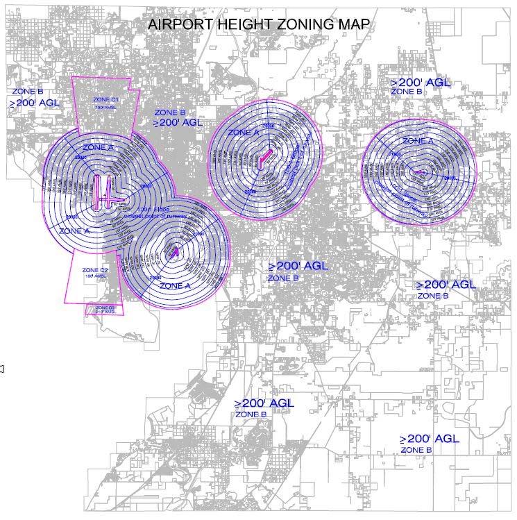
56 ATTACHMENT A1 55
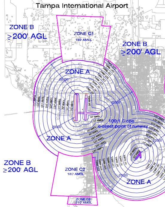
57 ATTACHMENT A2 56
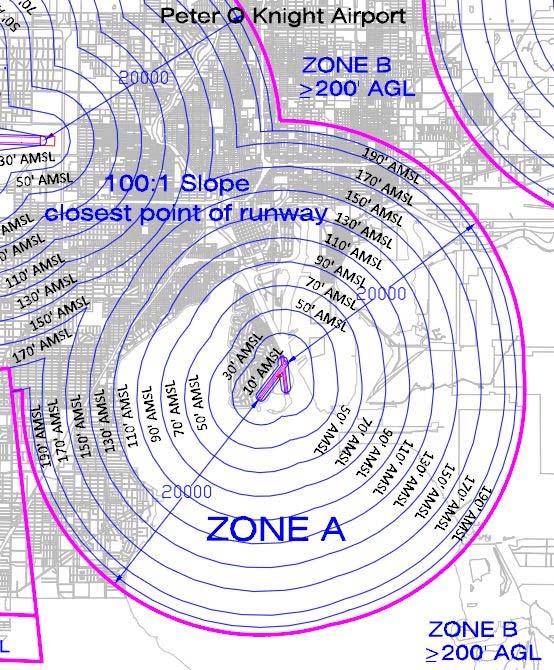
58 ATTACHMENT A3 57
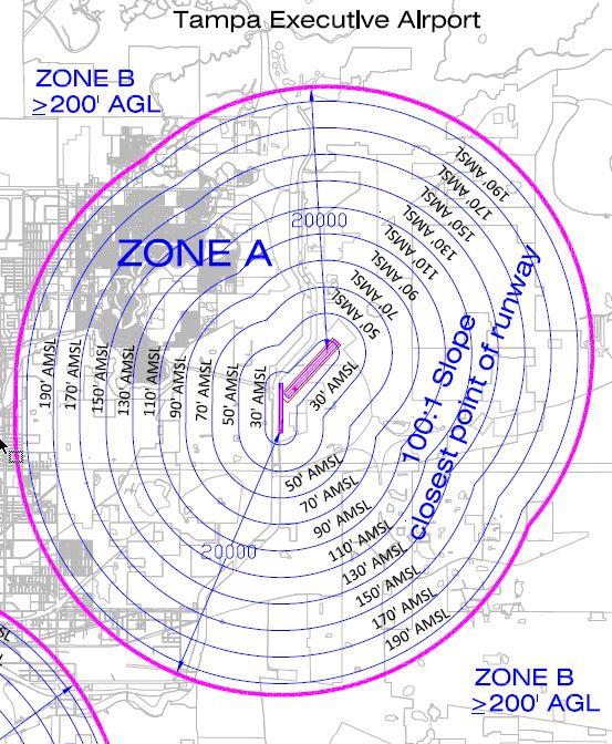
59 ATTACHMENT A4 58
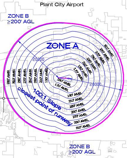
60 ATTACHMENT A5 59
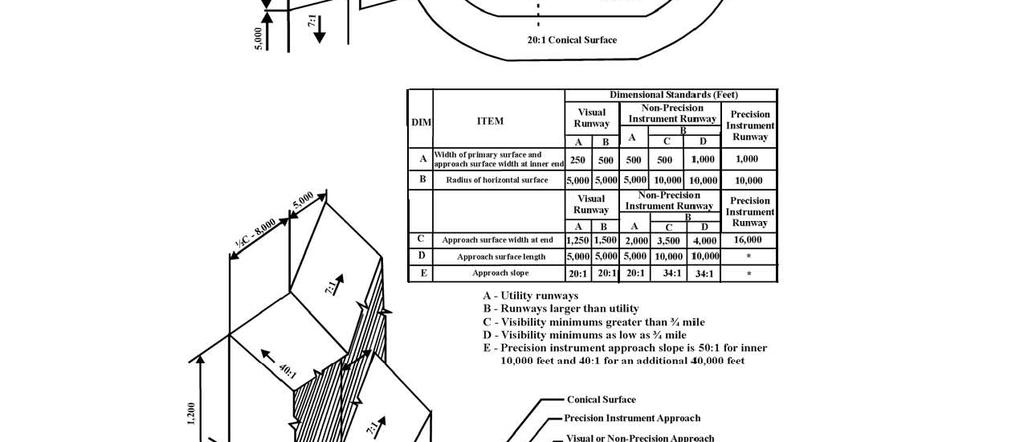
61 ATTACHMENT B 60
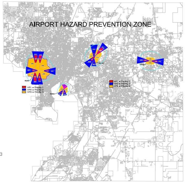
62 ATTACHMENT C1 61
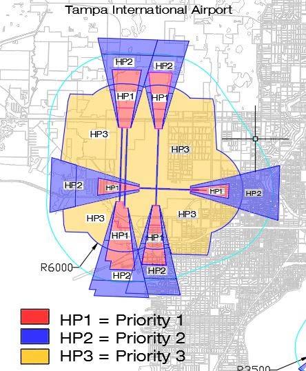
63 ATTACHMENT C2 62
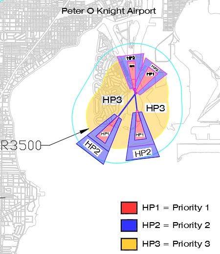
64 ATTACHMENT C3 63
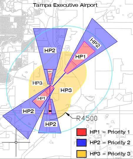
65 ATTACHMENT C4 64
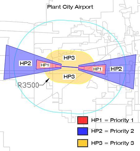
66 ATTACHMENT C5 65
67 ATTACHMENT D1 66
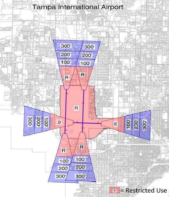
68 ATTACHMENT D2 67
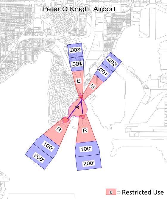
69 ATTACHMENT D3 68
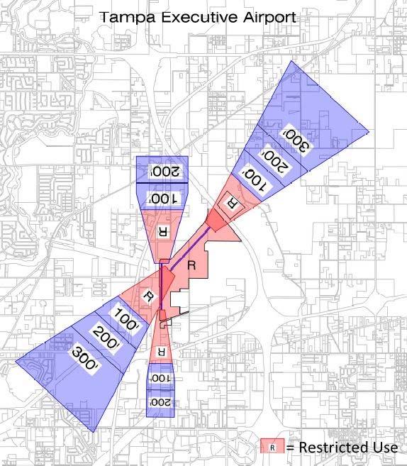
70 ATTACHMENT D4 69
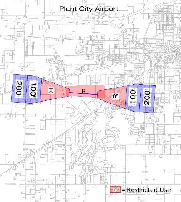
71 ATTACHMENT D5 70
ORDINANCE NO. _2013-
 ORDINANCE NO. _2013- AN ORDINANCE OF THE TOWNSHIP OF CONEWAGO, DAUPHIN COUNTY, PENNSYLVANIA, PROVIDING FOR AIRPORT ZONING REGULATIONS WITHIN THE AIRPORT ZONING OVERLAY DISTRICT CREATED BY THIS ORDINANCE
The following criteria shall be applied within the boundaries of the AO District:
 Sec. 419 (a) Purpose AIRPORT OVERLAY DISTRICT (AO) The purpose of the Airport Overlay District is to regulate and restrict the height of structures, objects, or natural growth, regulate the locations of
AIRPORT ZONING REGULATIONS for the City of McPherson, Kansas
 AIRPORT ZONING REGULATIONS for the City of McPherson, Kansas ARTICLE 1. TITLE, PURPOSE, AUTHORITY AND JURISDICTION 100 Title. These regulations, including the McPherson Airport Zoning Map made a part hereof,
Chapter AIRPORT ZONING
 Chapter 142 - AIRPORT ZONING ARTICLE I. - IN GENERAL Sec 142-1 Applicability The airport protection zoning regulations contained in this Chapter shall be applicable to the areas identified in Exhibit A,
APPENDIX D FEDERAL AVIATION REGULATIONS, PART 77
 APPENDIX D FEDERAL AVIATION REGULATIONS, PART 77 Subparts A through C PART 77 - OBJECTS AFFECTING NAVIGABLE AIRSPACE Subpart A General 77.1 Scope. 77.2 Definition of terms. 77.3 Standards. 77.5 Kinds of
-NOTE: NOT TO BE USED FOR NAVIGATION PURPOSES-
 APPENDIX 1-B INSTRUMENT APPROACH PROCEDURES March 2010 SKYHAVEN AIRPORT -NOTE: NOT TO BE USED FOR NAVIGATION PURPOSES- -NOTE: NOT TO BE USED FOR NAVIGATION PURPOSES- -NOTE: NOT TO BE USED FOR NAVIGATION
SITE ELEVATION AMSL...Ground Elevation in feet AMSL STRUCTURE HEIGHT...Height Above Ground Level OVERALL HEIGHT AMSL...Total Overall Height AMSL
 ******************************************** * Federal Airways & Airspace * * Summary Report * ******************************************** File: User Assigned File Name Latitude: NAD83 Coordinate Longitude:
Contents. Page 1 of 11 / Draft Chapter 142 Version CHAPTER AIRPORT ZONING... 2 ARTICLE I. - IN GENERAL... 2
 Contents CHAPTER 142 - AIRPORT ZONING... 2 ARTICLE I. - IN GENERAL... 2 Sec 142-1. - Applicability... 2 Secs. 142-2 142-35. - Reserved.... 3 ARTICLE II. - ST. PETERSBURG-CLEARWATER INTERNATIONAL AIRPORT
RULES OF TENNESSEE DEPARTMENT OF TRANSPORTATION AERONAUTICS DIVISION CHAPTER LICENSING AND REGISTRATION OF AIRPORTS TABLE OF CONTENTS
 RULES OF TENNESSEE DEPARTMENT OF TRANSPORTATION AERONAUTICS DIVISION CHAPTER 1680-1-2 LICENSING AND REGISTRATION OF AIRPORTS TABLE OF CONTENTS 1680-1-2-.01 Purpose 1680-1-2-.06 Repealed 1680-1-2-.02 Definitions
Boise Municipal Code. Chapter DEFINITIONS
 Chapter 12-03 DEFINITIONS Sections: 12-03-01 ADMINISTRATOR 12-03-02 AIRPORT DESIGNATIONS 12-03-03 AIRPORT HAZARD 12-03-04 AIRPORT HEIGHT LIMITATIONS 12-03-05 AIRPORT REFERENCE POINT 12-03-06 AIRPORT INSTRUMENT
Chapter Six ALP Drawings. Tacoma Narrows Airport. Master Plan Update
 Chapter Six ALP Drawings Master Plan Update The master planning process for the (Airport) has evolved through efforts in the previous chapters to analyze future aviation demand, establish airside and landside
Article 11 Airport District
 Cities County A Article 11 Article 11 Section 11.01 Intent (a) A. The A is established to provide for uses, activities, facilities, and structures necessary for the safe and efficient operation of aircraft
AIRSPACE PROTECTION. Guidance and considerations for development in the vicinity of Ohio s airports and heliports
 AIRSPACE PROTECTION Guidance and considerations for development in the vicinity of Ohio s airports and heliports UPDATED SPRING 2018 AIRSPACE PROTECTION When construction is proposed near public use airports
ARTICLE 16 AIRPORT REGULATIONS
 ARTICLE 16 AIRPORT REGULATIONS CHAPTER A GENERAL... 3 Section 1 Purpose and Intent... 3 Section 2 Short Title and Authority... 3 Section 3 Applicability... 3 Section 4 Definitions and Acronyms... 3 CHAPTER
Appendix C AIRPORT LAYOUT PLANS
 Appendix C AIRPORT LAYOUT PLANS Appendix C AIRPORT LAYOUT PLANS Airport Master Plan Santa Barbara Airport As part of this Airport Master Plan, the Federal Aviation Administration (FAA) requires the development
ARTICLE 34 AIRPORT HEIGHT COMBINING ZONE (AH) (Amended by Ordinance #295 Effective June 26, 2009)
 (Amended by Ordinance #295 Effective June 26, 2009)") ARTICLE 34 AIRPORT HEIGHT COMBINING ZONE (AH) (Amended by Ordinance #295 Effective June 26, 2009) Section 34.10 - Purpose and Intent The purpose of the Airport Height Combining Zone (AH) is to protect
ARTICLE 34 AIRPORT HEIGHT COMBINING ZONE (AH) (Amended by Ordinance #295 Effective June 26, 2009) Section 34.10 - Purpose and Intent The purpose of the Airport Height Combining Zone (AH) is to protect
NOTICE TO PROPOSED CITY PERMITS: ZONING HEIGHT RESTRICTIONS/APPROVAL PROCESS
 NOTICE TO PROPOSED CITY PERMITS: ZONING HEIGHT RESTRICTIONS/APPROVAL PROCESS Dear Prospective Permittee: The City of St Petersburg (City) issues permits for construction projects based on local and state
SUBCHAPTER E AIRSPACE
 PART 71 DESIGNATION OF CLASS A, B, C, D, AND E AIRSPACE AREAS; AIR TRAFFIC SERVICE ROUTES; AND REPORTING POINTS Sec. SPECIAL FEDERAL AVIATION REGULATION NO. 97 [NOTE] 71.1 Applicability. 71.3 [Reserved]
 Page 1 of 10 ARTICLE XXXIX. HOMESTEAD GENERAL AVIATION AIRPORT ZONING* *Editor's note: Article XXXIX, 33-372--33-387, is derived from Ord. No. 69-38, 1--16, enacted July 9, 1969. Section 17 of said ordinance
DRAFT MASTER PLAN UPDATE
 DRAFT MASTER PLAN UPDATE CHAPTER VI: AIRPORT LAYOUT PLAN NARRATIVE DRAFT REPORT APRIL 2017 PREPARED BY: Table of Contents WESTCHESTER COUNTY AIRPORT 6 AIRPORT LAYOUT PLAN NARRATIVE REPORT... 6-1 6.1 AGIS
Learning More About: Protecting and Evaluating Airspace for Airports
 Learning More About: Protecting and Evaluating Airspace for Airports Introduction Tall structures, smoke, and Tall Structures rising terrain are just a few conditions that can create hazardous conditions
PLANNING AND ZONING MEETING. March 20, 2019 AGENDA. 1. Review Minutes. 1
 PLANNING AND ZONING MEETING March 20, 2019 AGENDA 1. Review Minutes. 1 2. Appointments A. Land Use Map Discussion Horrocks Engineers.. 2 B. Airport Protection Ordinance. 3-8 3. Other Business 4. Adjourn
** DETERMINATION OF NO HAZARD TO AIR NAVIGATION **
 Mail Processing Center Federal Aviation Administration Southwest Regional Office Obstruction Evaluation Group 2601 Meacham Boulevard Fort Worth, TX 76137 Issued Date: 05/16/2011 Aeronautical Study No.
AVIATION PLANNING AND DEVELOPMENT Oakland International Airport 530 Water Street Oakland, CA 94607
 AVIATION PLANNING AND DEVELOPMENT Oakland International Airport 530 Water Street When Do I Need to File an FAA Form 7460-1? Objects Affecting Navigable Airspace (14CFR77) June 2013 Background The Federal
TITLE 16. DEPARTMENT OF TRANSPORTATION CHAPTER 62. AIR SAFETY AND ZONING
 NOTE: This is a courtesy copy of this rule. The official version can be found in the New Jersey Administrative Code. Should there be any discrepancies between this text and the official version, the official
Flying Cloud Airport (FCM) Zoning Process: Informing a Mn/DOT Path Forward
 Zoning Process: Informing a Mn/DOT Path Forward") : Informing a Mn/DOT Path Forward A Review of the Flying Cloud Airport (FCM) Joint Airport Zoning Board (JAZB) Process and the Draft Airport Zoning Ordinance B A RPZ RPZ A B C Zone Chad E. Leqve Director
: Informing a Mn/DOT Path Forward A Review of the Flying Cloud Airport (FCM) Joint Airport Zoning Board (JAZB) Process and the Draft Airport Zoning Ordinance B A RPZ RPZ A B C Zone Chad E. Leqve Director
Airport Obstruction Standards
 Airport Obstruction Standards Dr. Antonio Trani Department of Civil and Environmental Engineering Virginia Tech Outline of this Presentation Obstructions to navigation around airports Discussion of Federal
Overview ICAO Standards and Recommended Practices for Aerodrome Safeguarding
 Overview ICAO Standards and Recommended Practices for Aerodrome Safeguarding References The Convention on International Civil Aviation (Chicago Convention) ICAO SARPS Annex 14 Vol. I, 7 th Edition, July
APPENDIX K LAND USE. Charles M. Schulz - Sonoma County Airport Draft Environmental Impact Report July 2011 K-1
 APPENDIX K LAND USE Charles M. Schulz - Sonoma County Airport Draft Environmental Impact Report July 2011 K-1 Appendix K Land Use THIS PAGE INTENTIONALLY LEFT BLANK Charles M. Schulz - Sonoma County Airport
AIRPORT LAND USE COMPATILIBILTY AIRPORT LAND USE COMPATIBILIITY
 CHAPTER 7 AIRPORT LAND USE COMPATILIBILTY CHAPTER 7 AIRPORT LAND USE COMPATIBILIITY 7.0 INTRODUCTION On airport aviation related development is typically compatible with aircraft operations. On airport
TANZANIA CIVIL AVIATION AUTHORITY AIR NAVIGATION SERVICES INSPECTORATE. Title: CONSTRUCTION OF VISUAL AND INSTRUMENT FLIGHT PROCEDURES
 Page 1 of 8 1. PURPOSE 1.1. This Advisory Circular provides guidance to personnel involved in construction of instrument and visual flight procedures for publication in the Aeronautical Information Publication.
SOUTH DAKOTA STATE UNIVERSITY Policy and Procedure Manual
 Office/Contact: Division of Research and Economic Development Source: Federal Aviation Administration (FAA) UAS Regulations and Policies; SDBOR Policy 1:30; FAA Modernization and Reform Act of 2012 (P.L.
PART III CODE OF ORDINANCES Chapter 33 ZONING
 ARTICLE XL. - KENDALL TAMIAMI EXECUTIVE AIRPORT ZONING Sec. 33-388. - Short title. Sec. 33-389. - Provisions hereof established as minimum standards governing zoning. Sec. 33-390. - Definitions. Sec. 33-391.
Subtitle B Unmanned Aircraft Systems
 H. R. 658 62 (e) USE OF DESIGNEES. The Administrator may use designees to carry out subsection (a) to the extent practicable in order to minimize the burdens on pilots. (f) REPORT TO CONGRESS. (1) IN GENERAL.
** DETERMINATION OF NO HAZARD TO AIR NAVIGATION **
 Mail Processing Center Federal Aviation Administration Southwest Regional Office Obstruction Evaluation Group 2601 Meacham Boulevard Fort Worth, TX 76137 Issued Date: 01/04/2012 Aeronautical Study No.
Consideration will be given to other methods of compliance which may be presented to the Authority.
 Advisory Circular AC 139-10 Revision 1 Control of Obstacles 27 April 2007 General Civil Aviation Authority advisory circulars (AC) contain information about standards, practices and procedures that the
AIR NAVIGATION ORDER
 CLEARANCE AREAS AND OBSTACLE LIMITATION SURFACES AT AIR NAVIGATION ORDER VERSION : 2.0 DATE OF IMPLEMENTATION : 15-02-2013 OFFICE OF PRIME INTEREST : AERODROME STANDARDS BRANCH. (Directorate of Airspace
Administration Policies & Procedures Section Commercial Ground Transportation Regulation
 OBJECTIVE METHOD OF OPERATION Definitions To promote and enhance the quality of Commercial Ground Transportation, the public convenience, the safe and efficient movement of passengers and their luggage
STAFF REPORT. Airport Land Use Consistency Determination Betteravia Plaza. MEETING DATE: January 21, 2016 AGENDA ITEM: 8D
 STAFF REPORT SUBJECT: Airport Land Use Consistency Determination Betteravia Plaza MEETING DATE: AGENDA ITEM: 8D STAFF CONTACT: Andrew Orfila RECOMMENDATION: Adopt findings for the Betteravia Plaza project
USE OF RADAR IN THE APPROACH CONTROL SERVICE
 USE OF RADAR IN THE APPROACH CONTROL SERVICE 1. Introduction The indications presented on the ATS surveillance system named radar may be used to perform the aerodrome, approach and en-route control service:
Transportation Chapter ALABAMA DEPARTMENT OF TRANSPORTATION ADMINISTRATIVE CODE CHAPTER DEFINITIONS TABLE OF CONTENTS
 Transportation Chapter 450-9-2 ALABAMA DEPARTMENT OF TRANSPORTATION ADMINISTRATIVE CODE CHAPTER 450-9-2 DEFINITIONS TABLE OF CONTENTS 450-9-2-.01 Definitions 450-9-2-.01 Definitions. For the purpose of
FAA Requirements for Engine-out Procedures and Obstacle Clearance
 FAA Requirements for Engine-out Procedures and Obstacle Clearance Presentation to: CAAC Engine-out Procedures Seminar Name: Chuck Friesenhahn Date: 11/29/2005 Flight Standards Senior Advisor, Advanced
STAFF REPORT. Airport Land Use Plan Consistency Review: Old Town Village Mixed Use Project City of Goleta. MEETING DATE: June 18, 2015 AGENDA ITEM: 5M
 STAFF REPORT SUBJECT: Airport Land Use Plan Consistency Review: Old Town Village Mixed Use Project City of Goleta MEETING DATE: AGENDA ITEM: 5M STAFF CONTACT: Peter Imhof, Andrew Orfila RECOMMENDATION:
Mapleton Municipal Airport, Mapleton, Iowa Monona County, Iowa
 Monona County Ordinance No. 53 Chapter 300(b) Airport Land Use and Height Overlay Zoning Ordinance Mapleton Municipal Airport, Mapleton, Iowa Monona County, Iowa Table of Contents Section 1. Introduction
AIRPORT NOISE AND CAPACITY ACT OF 1990
 AIRPORT NOISE AND CAPACITY ACT OF 1990 P. 479 AIRPORT NOISE AND CAPACITY ACT OF 1990 SEC. 9301. SHORT TITLE This subtitle may be cited as the Airport Noise and /Capacity Act of 1990. [49 U.S.C. App. 2151
CHAPTER 61 SHEBOYGAN COUNTY MEMORIAL AIRPORT
 61.01 OPERATION OF AIRPORT 61.02 DEFINITION OF WORDS AND PHRASES 61.03 AIRPORT OPERATION POLICIES 61.04 UTILITIES 61.05 ENTRANCES 61.06 SPECIAL VARIANCE 61.07 ENFORCEMENT 61.08 PENALTY 61.09 MULTIPLE OWNERSHIP
Part 77 CAA Consolidation 1 April 2014 Objects and Activities Affecting Navigable Airspace
 Part 77 CAA Consolidation 1 April 2014 Objects and Activities Affecting Navigable Airspace Published by the Civil Aviation Authority of New Zealand DESCRIPTION Part 77 prescribes rules for persons proposing
Memorandum. Federal Aviation Administration. Date: June 19, Richard Doucette, Environmental Protection Specialist. From: To:
 Federal Aviation Administration Memorandum Date: June 19, 2008 From: To: Subject: Richard Doucette, Environmental Protection Specialist LaVerne Reid, Airports Division Manager John Donnelly, Regional Counsel
Part 77 and Construction
 Part 77 and Construction Presented to: By: Date: Advanced ASOS Steven Oetzell October 18, 2016 14 CFR Part 77, Objects Affecting Navigable Airspace Reporting objects to the FAA 14 CFR Part 139.331 states
** DETERMINATION OF NO HAZARD TO AIR NAVIGATION **
 Federal Aviation Administration Air Traffic Airspace Branch, ASW-520 2601 Meacham Blvd. Fort Worth, TX 76137-0520 Aeronautical Study No. 2010-WTE-13969-OE Issued Date: 09/30/2010 Morgan Johnston University
EAGLE RIVER UNION AIRPORT HANGAR CONSTRUCTION GUIDELINES Approved 1/29/2008
 EAGLE RIVER UNION AIRPORT HANGAR CONSTRUCTION GUIDELINES Approved 1/29/2008 SECTION 1 - PURPOSE AND SCOPE 1.1 Purpose This document is designed to serve as a guide for private and commercial hangar construction
CHG 0 9/13/2007 VOLUME 2 AIR OPERATOR AND AIR AGENCY CERTIFICATION AND APPLICATION PROCESS
 VOLUME 2 AIR OPERATOR AND AIR AGENCY CERTIFICATION AND APPLICATION PROCESS CHAPTER 5 THE APPLICATION PROCESS TITLE 14 CFR PART 91, SUBPART K 2-536. DIRECTION AND GUIDANCE. Section 1 General A. General.
Administration Policies & Procedures Section Commercial Ground Transportation Regulation
 OBJECTIVE METHOD OF OPERATION Definitions To promote and enhance the quality of Commercial Ground Transportation, the public convenience, the safe and efficient movement of passengers and their luggage
Airport Land Use Compatibility Plan (ALUCP) Update. Public Information Meeting #4 June 8 & 9, 2016
 Update. Public Information Meeting #4 June 8 & 9, 2016") Airport Land Use Compatibility Plan (ALUCP) Update Public Information Meeting #4 June 8 & 9, 2016 Agenda 1. Study Process 2. Noise Complaint Patterns 3. Proposed Overflight Areas (AOA) 4. Proposed Land
Airport Land Use Compatibility Plan (ALUCP) Update Public Information Meeting #4 June 8 & 9, 2016 Agenda 1. Study Process 2. Noise Complaint Patterns 3. Proposed Overflight Areas (AOA) 4. Proposed Land
Initiated By: AFS-400
 U.S. Department of Transportation Federal Aviation Administration Advisory Circular Subject: Development and Submission of Special Date: 04/14/2015 AC No: 90-112A Instrument Procedures to the FAA Initiated
AIRWORTHINESS CERTIFICATION OF AIRCRAFT AND RELATED PRODUCTS. 1. PURPOSE. This change is issued to incorporate revised operating limitations.
 8130.2D 2/15/00 AIRWORTHINESS CERTIFICATION OF AIRCRAFT AND RELATED PRODUCTS 1. PURPOSE. This change is issued to incorporate revised operating limitations. 2. DISTRIBUTION. This change is distributed
UNMANNED AIRCRAFT PROVISIONS IN FAA REAUTHORIZATION BILL
 UNMANNED AIRCRAFT PROVISIONS IN FAA REAUTHORIZATION BILL Section 341 Comprehensive Plan -Codifies in title 49 the requirement in the 2012 FAA reauthorization Act that a comprehensive plan to safely accelerate
Comparison Between Old and New ALUC Plans
 A P P E N I X H Comparison Between Old and New ALUC Plans OVERVIEW This Placer County Airport Land Use Compatibility Plan (ALUCP) sets forth land use compatibility criteria for the environs of Auburn Municipal,
Ordinance No Amendments to Airport Ordinance 87-8
 SECTION 1. SUMMARY. This Ordinance adds various provisions to uncodified County Ordinance 87-8 ("the Airport Regulations"), amends and renumbers various provisions of the Airport Regulations, and adds
Control of Cranes and Other Temporary Obstacles
 United Kingdom Overseas Territories Aviation Circular OTAC 139-27 140-11 171-8 172-11 178-10 Control of Cranes and Other Temporary Obstacles Issue 1 1 June 2018 Effective on issue GENERAL Overseas Territories
Notice of Extended Comment Period for an Intent to Adopt a Negative Declaration
 County of Santa Clara Department of Planning and Development Planning Office County Government Center, East Wing, 7 th Floor 70 West Hedding Street San Jose, California 95110-1705 (408) 299-5770 FAX (408)
TITLE 20 AERONAUTICS
 TITLE 20 AERONAUTICS CHAPTERS 1 General Provisions ( 101) 2 General Powers of the Secretary; National Preemption ( 201-202) 3 Organization of Civil Aviation Authority and Powers and Duties of the Secretary
AERONAUTICAL SURVEYS & INSTRUMENT FLIGHT PROCEDURES
 AERONAUTICAL SURVEYS & INSTRUMENT FLIGHT PROCEDURES Current as of November 2012 ALASKA AVIATION SYSTEM PLAN UPDATE Prepared for: State of Alaska Department of Transportation & Public Facilities Division
AERODROME LICENCE APPLICATION PROCESS
 0000180111 Page 2 Why is a Licence Required? An aerodrome licence is required for a site if it is intended to facilitate operations by commercial transport aircraft, other aerial work other than rotorcraft,
Table of Contents. List of Tables. Cincinnati/Northern Kentucky International Airport 2035 Master Plan Update
 Table of Contents 7.1. Airport Layout Plan (Existing Conditions)... 2 7.2. Airport Layout Plan (Future Conditions)... 3 7.3. Technical Data Sheet... 5 7.4. Commercial Terminal Area Drawing... 5 7.5. East
Rule Governing the Designation and Establishment of All-Terrain Vehicle Use Trails on State Land
 Rule Governing the Designation and Establishment of All-Terrain Vehicle Use Trails on State Land 1.0 Authority 1.1 This rule is promulgated pursuant to 23 V.S.A. 3506. Section 3506 (b)(4) states that an
USE OF REMOTELY PILOTED AIRCRAFT AND MODEL AIRCRAFT IN AVIATION
 luo Regulation 1 (10) OPS M1-32 Issued: 4 December 2018 Enters into force: 7 December 2018 Validity: indefinitely Legal basis: Aviation Act (864/2014), Sections 5, 9 and 57 Act on Transport Services (320/2017),
INTERNATIONAL CIVIL AVIATION ORGANIZATION FIRST MEETING OF DIRECTORS OF CIVIL AVIATION OF THE CARIBBEAN REGION (CAR/DCA/1)
") CAR DCA/1 20/09/02 INTERNATIONAL CIVIL AVIATION ORGANIZATION FIRST MEETING OF DIRECTORS OF CIVIL AVIATION OF THE CARIBBEAN REGION (CAR/DCA/1) (Grand Cayman, Cayman Islands, 8-11 October 2002) Agenda Item
CAR DCA/1 20/09/02 INTERNATIONAL CIVIL AVIATION ORGANIZATION FIRST MEETING OF DIRECTORS OF CIVIL AVIATION OF THE CARIBBEAN REGION (CAR/DCA/1) (Grand Cayman, Cayman Islands, 8-11 October 2002) Agenda Item
AGREEMENT FOR OPERATION OF THE AIR TRAFFIC CONTROL TOWER AT THE TRUCKEE TAHOE AIRPORT
 AGREEMENT FOR OPERATION OF THE AIR TRAFFIC CONTROL TOWER AT THE TRUCKEE TAHOE AIRPORT This AGREEMENT FOR OPERATION OF THE AIR TRAFFIC CONTROL TOWER SERVICES AT TRUCKEE TAHOE AIRPORT ( Agreement ) is made
AMENDMENT No. 8 TO THE INTERNATIONAL STANDARDS AND RECOMMENDED PRACTICES AERODROMES ANNEX 14 TO THE CONVENTION ON INTERNATIONAL CIVIL AVIATION
 AMENDMENT No. 8 TO THE INTERNATIONAL STANDARDS AERODROMES ANNEX 14 TO THE CONVENTION ON INTERNATIONAL CIVIL AVIATION VOLUME I AERODROME DESIGN AND OPERATIONS The amendment to Annex 14, Volume I contained
Chapter 6. Airports Authority of India Manual of Air Traffic Services Part 1
 Chapter 6 6.1 ESSENTIAL LOCAL TRAFFIC 6.1.1 Information on essential local traffic known to the controller shall be transmitted without delay to departing and arriving aircraft concerned. Note 1. Essential
PART 210 NOISE ABATEMENT AND RUNWAY PROCEDURES NOISE ABATEMENT AND PREFERENTIAL RUNWAY USE PROCEDURES
 PART 210 NOISE ABATEMENT AND RUNWAY PROCEDURES 210.01 NOISE ABATEMENT AND PREFERENTIAL RUNWAY USE PROCEDURES 210.01-1 Establishment Of Procedures; FAA Guidelines This Rule establishes preferential runway
UNITED STATES OF AMERICA FEDERAL AVIATION ADMINISTRATION WASHINGTON D.C. GRANT OF EXEMPTION
 In the matter of the petition of the DEPARTMENT OF DEFENSE UNITED STATES OF AMERICA FEDERAL AVIATION ADMINISTRATION WASHINGTON D.C. Exemption No. 5100B For an exemption from the provisions 25863 Of sections
UNITED STATES OF AMERICA FEDERAL AVIATION ADMINISTRATION WASHINGTON D.C. GRANT OF EXEMPTION
 In the matter of the petition of the DEPARTMENT OF DEFENSE UNITED STATES OF AMERICA FEDERAL AVIATION ADMINISTRATION WASHINGTON D.C. Exemption No. 5100C For an exemption from the provisions 25863 Of sections
Windmills & Airspace Can We Work Together?
 May 29, 2008 Windmills & Airspace Can We Work Together? J. Randolph Babbitt C O N F I D E N T I A L www.oliverwyman.com Windmills & Airspace Overview of Airspace Issues For Wind Turbine Sites The FAA s
STAFF REPORT. Airport Land Use Plan Consistency Review: Santa Barbara Airport Master Plan. MEETING DATE: November 19, 2015 AGENDA ITEM: 7D
 STAFF REPORT SUBJECT: Airport Land Use Plan Consistency Review: Santa Barbara Airport Master Plan MEETING DATE: AGENDA ITEM: 7D STAFF CONTACT: Peter Imhof, Andrew Orfila RECOMMENDATION: Adopt findings
Electronic Terrain and Obstacle Data
 International Civil Aviation Organization Electronic Terrain and Obstacle Data David Lewtas Chief, Aeronautical Information Unit (MET/AIM) 24 November 2010 ICAO CAR AIM Seminar Kingston, Jamaica 22-24
THE BURBANK-GLENDALE-PASADENA AIRPORT AUTHORITY S UPDATE REGARDING ITS NOISE IMPACT AREA REDUCTION PLAN AND ITS PART 161 STUDY SECOND QUARTER 2015
 THE BURBANK-GLENDALE-PASADENA AIRPORT AUTHORITY S UPDATE REGARDING ITS NOISE IMPACT AREA REDUCTION PLAN AND ITS PART 161 STUDY SECOND QUARTER 2015 Pursuant to the California Department of Transportation
Runway and Taxiway Marking
 Lecture-38 10CV63 TE-II Runway and Taxiway Marking In order to aid pilots in guiding the aircraft on runways and taxiways, pavements are marked with lines and numbers. These markings are of benefit primarily
** DETERMINATION OF NO HAZARD TO AIR NAVIGATION **
 Mail Processing Center Federal Aviation Administration Southwest Regional Office Obstruction Evaluation Group 2601 Meacham Boulevard Fort Worth, TX 76137 Issued Date: 07/03/2013 Aeronautical Study No.
Oklahoma State University Policy and Procedures
 Oklahoma State University Policy and Procedures TEAM TRAVEL 1-0402 GENERAL UNIVERSITY March 2015 1.01 Purpose A. To provide a framework for safe and efficient athletic team travel for the Oklahoma State
FAI Sporting Code. Section 11 Humanpowered Aircraft CLASS I Edition Approved by the FAI Air Sport General Commission (CASI) on October 13, 2011
 on October 13, 2011") FAI Sporting Code Section 11 Humanpowered Aircraft CLASS I 2011 Edition Approved by the FAI Air Sport General Commission (CASI) on October 13, 2011 NOTE: Section 11 and General Section combined make up
FAI Sporting Code Section 11 Humanpowered Aircraft CLASS I 2011 Edition Approved by the FAI Air Sport General Commission (CASI) on October 13, 2011 NOTE: Section 11 and General Section combined make up
1.1.3 Taxiways. Figure 1-15: Taxiway Data. DRAFT Inventory TYPICAL PAVEMENT CROSS-SECTION LIGHTING TYPE LENGTH (FEET) WIDTH (FEET) LIGHTING CONDITION
 WIDTH (FEET) LIGHTING CONDITION") 1.1.3 Taxiways EWN has an extensive network of taxiways and taxilanes connecting the terminal, air cargo, and general aviation areas with the runways as listed in Figure 1-15. A 50-foot wide parallel taxiway
1.1.3 Taxiways EWN has an extensive network of taxiways and taxilanes connecting the terminal, air cargo, and general aviation areas with the runways as listed in Figure 1-15. A 50-foot wide parallel taxiway
Sample Regulations for Water Aerodromes
 Sample Regulations for Water Aerodromes First Edition (unedited version) March 2015 Notice to users: This document is an unedited version which is made available to the public for convenience. Its content
Introduction. Who are we & what do we do.
 Drones and the Law Introduction FAA s Regulations vs. Congress Legislation Recreational Use vs. Academic Use Private Property vs. Public Airspace Flying in Class B Airspace Working with MassPort Helpful
2. CANCELLATION. AC 39-7B, Airworthiness Directives, dated April 8, 1987, is canceled.
 U.S. Department of Transportation Federal Aviation Administration Advisory Circular Subject: AIRWORTHINESS DIRECTIVES Date: 11/16/95 AC No: 39-7C Initiated by: AFS-340 Change: 1. PURPOSE. This advisory
Noble Energy, Inc. MX3501-N Communication Tower. FAA and FCC Data
 Noble Energy, Inc. MX3501-N Communication Tower FAA and FCC Data Submitted to: Garfield County Building & Planning Department OA Project No. 011-2632 January 10, 2012 Notice Criteria Tool https://oeaaa.faa.gov/oeaaa/external/gistools/gisaction.jsp?action=dononoticerequired...
Source: Chippewa Valley Regional Airport ASOS, Period of Record
 Chapter 1 Inventory Runway wind coverage is the percentage of time a runway can be used without exceeding allowable crosswind velocities. Allowable crosswind velocities vary depending on aircraft size
PART 107 SMALL UNMANNED AIRCRAFT SYSTEMS 597 Sec. Subpart A General Applicability Definitions Falsification, reproduction or
 PART 107 SMALL UNMANNED AIRCRAFT SYSTEMS 597 Sec. Subpart A General 107.1 Applicability. 107.3 Definitions. 107.5 Falsification, reproduction or alteration. 107.7 Inspection, testing, and demonstration
Unmanned Aircraft System (Drone) Policy
 Policy") Unmanned Aircraft System (Drone) Policy Responsible Officer: Chief Risk Officer Responsible Office: RK - Risk / EH&S Issuance Date: TBD Effective Date: TBD Last Review Date: New Policy Scope: Includes
Unmanned Aircraft System (Drone) Policy Responsible Officer: Chief Risk Officer Responsible Office: RK - Risk / EH&S Issuance Date: TBD Effective Date: TBD Last Review Date: New Policy Scope: Includes
It is essential that planning take full account of air safety and efficiency of operations.
 Airspace Protection Airspace Protection It is essential that planning take full account of air safety and efficiency of operations. 7.1 INTRODUCTION Obstacles near an airport, whether they are natural
Introduction. Appendix D: Airspace Protection
 Preliminary PreliminaryDraft DraftMaster MasterPlan Plan Bankstown Airport Introduction : Airspace Protection D Preliminary Master Plan Draft Master Plan Airspace protection D1 OVERVIEW The protection
CHAPTER 6 NOISE EXPOSURE
 CHAPTER 6 NOISE EXPOSURE FAA requires that the NEM submitted for review represent the aircraft noise exposure for the year of submittal (in this case 2008) and for a future year (2013 for OSUA). However,
Staff Instruction. Aerial Assessment Requirements Prior to Heliport Certification
 Staff Instruction Subject: Aerial Assessment Requirements Prior to Heliport Certification Issuing Office: Standards Document No.: SI 305-001 File Classification No.: Z 5000-32 Issue No.: 01 RDIMS No.:
** DETERMINATION OF NO HAZARD TO AIR NAVIGATION **
 Mail Processing Center Federal Aviation Administration Southwest Regional Office Obstruction Evaluation Group 10101 Hillwood Parkway Fort Worth, TX 76177 Issued Date: 07/29/2016 Aeronautical Study No.
N Registry Airworthiness & Maintenance Requirements
 N Registry Airworthiness & Maintenance Requirements State of Registry Requirements Designee Limits and Requirements Maintenance Requirements Presented to: 6 th Airworthiness Safety Seminar By: Date: June
SECTION 2 - GENERAL REGULATIONS
 SECTION 2 - GENERAL REGULATIONS 2.01 COMPLIANCE WITH RULES AND REGULATIONS a. Any permission granted by the City, directly or indirectly, expressly, or by implication or otherwise, to any Person to enter
THE BURBANK-GLENDALE-PASADENA AIRPORT AUTHORITY S UPDATE REGARDING ITS NOISE IMPACT AREA REDUCTION PLAN AND ITS PART 161 STUDY FIRST QUARTER 2015
 THE BURBANK-GLENDALE-PASADENA AIRPORT AUTHORITY S UPDATE REGARDING ITS NOISE IMPACT AREA REDUCTION PLAN AND ITS PART 161 STUDY FIRST QUARTER 2015 Pursuant to the California Department of Transportation
CHAPTER 5 SEPARATION METHODS AND MINIMA
 CHAPTER 5 SEPARATION METHODS AND MINIMA 5.1 Provision for the separation of controlled traffic 5.1.1 Vertical or horizontal separation shall be provided: a) between IFR flights in Class D and E airspaces
CHAPTER 55. LICENSING OF AERONAUTICAL ACTIVITIES. Chapter Authority: N.J.S.A. 6:1-29, 6:1-43, 6:1-44, 27:1A-5, and 27:1A-6. Chapter Expiration Date:
 CHAPTER 55. LICENSING OF AERONAUTICAL ACTIVITIES Chapter Authority: N.J.S.A. 6:1-29, 6:1-43, 6:1-44, 27:1A-5, and 27:1A-6. Chapter Expiration Date: Expires on July 12, 2023. SUBCHAPTER 1. GENERAL PROVISIONS