REPUBLIC OF SOUTH AFRICA
|
|
|
- Rosalind Flowers
- 6 years ago
- Views:
Transcription

1 SAIHC8-5.3B REPUBLIC OF SOUTH AFRICA SAN HYDROGRAPHIC OFFICE NATIONAL REPORT TO THE 8 TH SOUTHERN AFRICA AND ISLANDS HYDROGRAPHIC COMMISSION MEETING (SAIHC) SEPTEMBER 2011 (WALVIS BAY, NAMIBIA)
2 2 CONTENTS 1. SA Navy Hydrographic Office (SANHO) Personnel 2. Hydrographic Surveys 3. Charts and Publications a. Charts International Charts National Paper Charts Vessel Traffic Service (VTS) & Traffic Separation Schemes (TSS) Small Craft Charts World Geodetic System (WGS 84) Print-on-Demand (PoD) Electronic Navigation Charts (ENCs) ENC Production ENC Production Priority Distribution Dissemination of ENC and related information b. Publications 4. Capacity Building Regional Capacity Building Initiatives Tide Gauge Installation Training 5. IHO Special Publication C Oceanographic activities General Bathymetric Chart of the Oceans (GEBCO) IBCWIO Project (Int Bathymetric Chart of the West Indian Ocean) Tide Gauge Network 7. Appendix A Status of Hydrographic Surveys along the RSA and Namibian Coastline
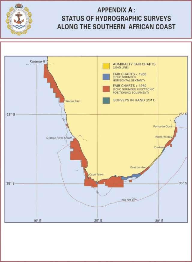
3 3 8 th SAIHC MEETING REPORT BY THE REPUBLIC OF SOUTH AFRICA 1. SA Navy Hydrographic Office (SANHO) The SA Hydrographic Service is a government-funded service and is part of the SA Navy. The major assets for the Hydrographic Service is as follows: One Hecla Class Hydrographic Survey Vessel, namely SAS PROTEA. She carries on board two smaller survey launches that are deployed for shallow water surveys. There is an additional launch on a trailer and equipment that is used as a mobile survey unit. The Hydrographic Office, with the following principal functions: Conduct hydrographic surveys, produce paper nautical charts, electronic navigation charts (ENCs) and publications including List of Lights and Radio Signals, three volumes of Sailing Directions, maintaining a tide gauge network and provide tidal information, collect GEBCO data, issue Monthly Notices to Mariners, Radio Navigational Warnings and the provision of a Chart Depot service. The officers and ship s company of the survey vessel SAS PROTEA; and The staff members of the Hydrographic Office (SANHO) at Cape Town, Tokai. Personnel. Technical staff recruitment in the Hydrographic Office remains a serious problem. The loss of cartographers to the private sector over the past years and the need to recruit suitably skilled staff to replace them and the aging work force in the Office, is being addressed. The SANHO has four full time marine cartographers working on paper chart production and one full time marine cartographer working on ENC production. 2. Hydrographic Surveys There are areas along the RSA southeast coast that have not been surveyed using electronic methods and last surveyed in the early 1900 s by hand lead line. This area is progressively being filled in by modern electronic methods. There is approximately another ten years of survey work remaining to cover the entire coast with modern survey methods. In the mean time the EEZ will continue to also receive some attention (Appendix A). 3. Charts and Publications a. Charts International (INT) charts. South Africa is the coordinator for charting Region H and the producer nation for 36 paper charts as part of the Region H International (INT) charting Scheme, of which 32 (89%) have been published. Three national paper charts have been allocated INT numbers and IHO adopted into the scheme as INT charts. Some of these charts have undergone a second round of revision. INT Chart No SAN No TITLE Medium Scale : 1 : * Kunene River to Sand Table Hill.
4 4 * Sand Table Hill to Cape Cross. * Cape Cross to Conception Bay. * Conception Bay to Hottentot Point. * Hottentot Point to Chamais Bay. * Chamais Bay to Port Nolloth. * Port Nolloth to Island Point. * Island Point to Cape Deseada. * Cape Deseada to Table Bay. * Table Bay to Cape Agulhas. * Cape Agulhas to Cape St Blaize. * Cape St Blaize to Cape St Francis. * Cape St Francis to Great Fish Point. * Great Fish Point to Mbashe Point. * Tugela River to Ponta do Ouro. Small Scale : 1 : Baia dos Tigres to Walvis Bay. Large Scale : Between 1 : : * Walvis Bay and Approaches. * Approaches to Lüderitz. * Approaches to Saldanha Bay * Saldanha Bay Harbour. * Approaches to Table Bay. * Table Bay Harbour. * Mossel Bay and Approaches. * Approaches to Port Elizabeth. * Port Elizabeth and Bird Island Passage. * Ngqura Harbour. * East London and Approaches. * Approaches to Durban. * Durban Harbour. * Approaches to Richards Bay. * Richards Bay Harbour. Note: * Indicates charts adopted by the UKHO. The following paper charts are at early or advanced stages of production: Mbashe Point to Port Shepstone Port Shepstone to Tugela River. * Entrance to Saldanha Bay. * Approaches to Durban Single Point Mooring (SPM). * IHO adopted as new INT charts. Region M: Antarctica. Approaches to Dronning Maud Land. National paper charts. The South African paper chart folio consists of some 100 national and international (INT) charts at various scale categories ranging from large scale harbour charts, port approach charts, medium scale coastal navigation charts to 1:10 (Million) small scale charts for passage planning around the southern tip of Africa and adjacent islands.
5 Namibia still remains the charting responsibility of South Africa and charting mainly consists of two hub ports, Walvis Bay and Lüderitz, while the coastline is covered by medium scale international (INT) paper charts. The SA national 1: scale coastal series have been discontinued some years ago with the publication of the 1: scale INT charts. All paper charts are regularly maintained by the promulgation of monthly Notices to Mariners (NMs) and revised to meet with IHO international charting standards and to maintain standardization. The SANHO adopts a proactive approach by visiting main activity areas from time to time to ensure that the most up to date information is available to the Hydrographic Office for promulgation. Vessel Traffic Service (VTS) and Traffic Separation Schemes (TSS). Vessel Traffic Services (VTS) have been implemented at the main hub ports of Saldanha Bay, Table Bay, Port Elizabeth, Durban and Richards Bay. With the commission of the new deepwater commercial port of Ngqura in October 2009, 10 miles to the north of Port Elizabeth, it was necessary to revise a new VTS system to cover approaches to both ports. Consideration is also being given to Mossel Bay and East London. Secondly, a Traffic Separation Scheme (TSS), which has been adopted by the International Maritime Organisation (IMO), has been implemented off the south coast to ensure safe navigation of laden tankers either side of the Alphard Banks and the FA Platform. Due to the on-going oil exploration activities approximately 65 nautical miles south west of Mossel Bay, careful navigation is essential in these waters particular in the vicinity of the Oribi and Sable Oil Fields as well as the E.M. Control Buoy. Small Craft Charts. The Hydrographic Office continues to maintain and provide small craft paper charts to the leisure market. These are unique in a sense that they cover a general coastal area at a scale of 1: , are half standard chart size, provides condensed sailing directions, show seasonal wind roses, facility diagrams and detailed larger scale inset plans of fishing harbours, yacht clubs and marinas. All this information is on one sheet printed front and back providing a comprehensive user document. Six (6) of these charts have been published. Added to this, in similar format, is the popular leisure craft chart SAN 2051 of the Vaal Dam, one of South Africa s largest inland dams situated approximately 80 kilometres south of Johannesburg in the Gauteng province. It is the intension to re-instate the Gariep Dam chart SAN 2053 towards the second part of It is located on the Orange River, situated about 35km north of Colesberg, which forms the provincial boundary between the Free State and Eastern Cape. World Geodetic System (WGS 84). Prior to 1997 all navigational charts were referenced to the Clarke 1880 modified ellipsoid. With the advent of the Global Positioning System (GPS) the WGS84 ellipsoid as a reference for positioning, it has become the spheroid for all new charts and new editions. Forty two charts (42%) have been published on WGS84, but if not considering smallscale charts where the WGS 84 shift is considered negligible, the figure changes significantly to 88%. However, it will be several years before the full South African paper chart folio, totalling some 100 charts, will be fully converted. Print-on-Demand (PoD). The Office is currently producing paper charts using CorelDraw to produce the repromat in film positive output from an AO image setter for use in conventional lithographic printing. In addition, these CorelDraw files may also be used for PoD printing. Presently the office can provide 70 charts (70%) using this process. The office has acquired two AO inkjet printers (Epson 9600/9800) to support an in-house PoD facility. Electronic Navigational Charts (ENCs). The SANHO utilizes dkart software for electronic navigational chart (ENC) production and conversion of paper survey records into digital format. This suite of software includes modules for sounding selection, colour banding, as well as a module for producing WECDIS based Additional Military Layer (AML) digital charts. DKart Hydrographer is also used to assess digitally captured survey data. 5
.")

6 The SANHO currently has six dkart Editor licences, four dkart Publisher licences and one licence each of dkart Navaids, Catalogue Server and Archives. Validation tools used are dkart Inspector (built into Editor, one licence of Seven C s Analyser and Transas NaviSailor 3000). The Office has recently installed a new dedicated 6TB storage device to accommodate the digital survey data obtained from the multi-beam survey system on SAS PROTEA. ENC Production South Africa has chosen the following paper chart - ENC relationship: 6 Chart Series SAN Harbour charts SAN Approaches charts SAN and Series charts SAN , Series SAN Series and all other small scales ENC Usage Band Harbour Approaches Coastal General Overview The cells in the Harbour and Approaches bands are the equivalent of the paper chart wrt coverage area but cells in the Coastal, General and Overview usage bands are compiled from more than one paper chart. All cells conform to the current international guidelines for SCAMIN and data consistency. ENC Production Priority All South African and Namibian Ports and Approaches are fully covered by ENCs. In addition, all ENCs in the Coastal, General and in the Overview usage band have been published. Status of Harbour Usage Band Coverage Status of Approaches Usage Band Coverage Status of Coastal Usage Band Coverage Status of General Usage Band Coverage


7 7 Status of Overview Usage Band Coverage South African ENC Products (as at 16 August 2011) IC-ENC Product Ref ZA ZA ZA ZA ZA ZA ZA ZA ZA ZA ZA ZA ZA ZA ZA ZA ZA ZA ZA ZA4N0010 Cell Title Saldanha Bay Table Bay Simon's Bay Mosselbaai Harbour Port Elizabeth Harbour Ngqura Harbour East London Harbour Durban Harbour Richards Bay Harbour Approaches to Saldanha Bay Approaches to Table Bay False Bay Approaches to Mossel Bay Approaches to Port Elizabeth Bird Island Passage Approaches to East London Durban Oil Terminal SMB Approaches to Durban Approaches to Richards Bay Approaches to Walvis Bay
8 8 ZA4N0020 ZA ZA ZA ZA ZA ZA ZA ZA ZA ZA ZA ZA ZA ZA3N0010 ZA3N0020 ZA3N0030 ZA3N0040 ZA3N0050 ZA ZA ZA ZA ZA ZA2N0010 ZA2N0020 ZA2N0030 ZA2N0040 ZA ZA ZA ZA1N0010 ZA1N0020 Approaches to Lüderitz Oranjemund to Skulpfonteinpunt Hondeklipbaai to Olifantsrivier Doringbaai to Yzerfonteinpunt Dassen Island to Kaap Hangklip Mudge Point to Cape Infanta Cape Barracouta to Cape Seal Storm Point to Port Alfred Great Fish Point to Cape Morgan Mbashe Point to North Sand Bluff Port Shepstone to Tongaat Bluff Tugela River to Cape St Lucia Cape Vidal to Ponta do Ouro Approaches to Dronning Maud Land Kunene River to Sand Table Hill Terrace Bay to Cape Cross Farilhao Point to Conception Bay Meob Bay to Hottentot Point Douglas Point to Orange River Orange River to Stompneuspunt Cape Columbine to Cape Infanta Cape Barracouta to Cape Padrone Great Fish Point to Cape Hermes South Sand Bluff to Ponta do Ouro Kunene River to Palgrave Point Haub River to Conception Bay Meob Bay to Elizabeth Bay Driemasterpunt to Orange River Western Waters of South Africa Southern Waters of South Africa Eastern Waters of South Africa Northern Waters of Namibia Southern Waters of Namibia Scope of ENC Work done Usage Band Total Total % Coverage Planned Produced Available Overview General Coastal Approaches Harbour Berthing Total % Outstanding cell production ZA Prince Edward and Marion Islands Distribution of ENCs South African commercial ENCs are distributed through IC-ENC (UK).
9 9 Dissemination of ENC and related information The South African Hydrographic Office maintains its own web site ( which provides information on its ENC program as well as information concerning ENC, Charts and Carriage Requirements, arising from the joint work of Primar, IC-ENC and the Working Group on Information (PSIWG). b. Publications The present status of most essential SANHO Publications is as given in the table below; SANHO Ref No Title Edition SAN HO-1 South African List of Lights and Radio Signals 2008 SAN HO-2 South African Tide Tables 2011 & 2012 SAN HO-3 Catalogue and Indexes of SAN Charts and other Pubs And a revised digital version SAN HO-6(INT 1) Symbols and Abbreviations used on SA Charts 2009 SAN HO-15 International Regulations for Preventing Collisions at 2005 Sea 1972 (COLREGS) SAN HO-21 SA Sailing Directions Vol I General Information 2005 SAN HO-22 SA Sailing Directions Vol II Namibia and West Coast 2002 SAN HO-23 SA Sailing Directions Vol III South and East Coasts 2003 Annual Summary of SA Notices to Mariners 2011 Cumulative List of SA Notices to Mariners 2011 The above publications are maintained through the promulgation of monthly NM s and generally fully revised at 2 to 3 year intervals. Charts and Publication information and Tidal Data are also made available on the SANHO web site ( and may be downloaded as convenient. 4. Capacity Building Regional capacity building initiatives. SAIHC have identified Capacity Building initiatives with MSI as a very important first phase component. During early 2011 advisory visit teams visited Namibia, Malawi, the Comores and Madagascar. Angola was not visited at this time as planned. Member countries are encouraged to establish contact and sensitise their governments about the importance of hydrography. The main objective is to utilise regional projects to facilitate the improvement of hydrography through capacity building. Tide gauge installation. The Benguela Current Large Marine Ecosystem Project (BCLME) and the Intergovernmental Oceanographic Commission (IOC-UNESCO) approached South Africa to install two Radar type tide gauges at the ports of Walvis Bay and Lüderitz, Namibia. At the request of the IOC, a satellite transmitter was installed at Walvis Bay. It has been confirmed by the IOC, BCLME and NAMPORT that the project was a success. Training. The SAIHC Capacity Building management plan included a WWNWS-MSI training course in April 2010 in Walvis Bay, Namibia. This took place with the course rated a success. It is hoped that it would stimulate a capability increase through the empowerment of national co-
10 ordinators. The ultimate aim of capacity building is to increase MSI awareness in national waters. All member states are encouraged to submit this initiative through the RHC (SAIHC). At the 9 th CBSC Meeting, a Phase 1 Skills and Chart Awareness Course have been approved for SAIHC for 2012 and have been incorporated in the 2012 Capacity Building work programme. Hydrographic Survey Courses and Data Processing and Marine Cartography Modules were presented at SANHO in 2010 and 2011 during which training was provided to four international learners from Malawi and Nigeria. Other countries also expressed interest in receiving training in South Africa but no nominations were received. The courses presented are highlighted in the tables below: 10 Hydrographic Surveying Course Period Participants Hydrographic Survey Recorder Course Part 2. 3 May 11 June 2010 Nigeria (2) Hydrographic Survey Recorder Course Part 3 / 23 Aug 12 Nov 2010 Nigeria (1) Basic survey for Officers. Hydrographic Survey Recorder Course Part Jan 25 Feb 2011 South Africa (11) Hydrographic Survey Recorder Course Part Apr 11 Jun 2011 No takers Hydrographic Survey Recorder Course Part 3 22 Aug 11 Nov 2011 South Africa (2) Data Processing and Marine Cartography Course Period Participants Hydrographic Data Processing and Marine Cartography including specialist ENCs (Module 17 May 18 June 2010 South Africa (9) Malawi (1) 1). Presented by the UKHO in South Africa. Module Jan 18 Feb 2011 South Africa (10) Module Sep 14 Oct 2011 South Africa (8) 5. IHO Special Publication C-55 The South African Hydrographic Office acknowledges the importance of the constant review of C- 55 to improve hydrographic services along the maritime routes in the region. A comprehensive update was provided to the IHO in February The status of Namibia is included in South Africa s assessment. 6. Oceanographic activities General Bathymetric Chart of the Oceans (GEBCO). Since 1991, South Africa has, in accordance with IHO Resolutions, ceased to maintain the 20 GEBCO Collector Plotting Sheets (passage soundings) for which the RSA is responsible. The analogue sheets of South Africa s GEBCO data holdings have been converted into digital format, which will greatly contribute to the use of this data in digital products and the production of the International Bathymetric Chart of the West Indian Ocean (IBCWIO) project. IBCWIO Project (International Bathymetric Chart of the West Indian Ocean). This is a joint mapping project between the IHO and the International Oceanographic Commission (IOC) to chart
11 the eastern side of Africa, from approximately 13 N to 36 S extending seaward to as far as 68 E, at a scale of 1: Of the 21 sheets needed, South Africa undertook to produce sheets inclusive. South Africa has suspended work on this project due to its lack of personnel and prioritising of its ENC production program. Tide Gauge Network. The tide gauge network is critical in the calculation of the tidal predictions for South Africa and Namibia, and spans from Port Nolloth on the West Coast to Richards Bay on the East Coast. Since the end of 2001 the tide gauge network has progressively being replaced with modern radar type tide gauges. The South African Navy Tide Gauge Network has now been completely upgraded with all ten tidal stations having radar type gauges. Biannual calibration and maintenance site visits are carried out by the Tidal Department. At the request of the IOC, satellite transmitters were installed at 3 tidal stations, two of which are Global Sea level Observing System (GLOSS) stations. The 1min data from Durban, Port Elizabeth and Simon s Town is transmitted in real time for use in the Indian Ocean Tsunami Early Warning System (IOTWS). Chart Datum for all SA Ports was changed from a standard 0.900m below MSL to Lowest Astronomical Tide (LAT) as from 1 January
12
REPUBLIC OF SOUTH AFRICA
 SAIHC10-5.1F REPUBLIC OF SOUTH AFRICA SAN HYDROGRAPHIC OFFICE NATIONAL REPORT TO THE 10 TH SOUTHERN AFRICA AND ISLANDS HYDROGRAPHIC COMMISSION CONFERENCE (SAIHC) 17-18 SEPTEMBER 2013 (PORTUGAL) 2 CONTENTS
SAN HYDROGRAPHIC OFFICE NATIONAL REPORT to the 14 TH SOUTHERN AFRICA AND ISLANDS HYDROGRAPHIC COMMISSION CONFERENCE (SAIHC) 6-8 September 2017
 6-8 September 2017") Inter-Regional Coordinating Committee SAN HYDROGRAPHIC OFFICE NATIONAL REPORT to the 14 TH SOUTHERN AFRICA AND ISLANDS HYDROGRAPHIC COMMISSION CONFERENCE (SAIHC) 6-8 September 2017 Principal functions:
Inter-Regional Coordinating Committee SAN HYDROGRAPHIC OFFICE NATIONAL REPORT to the 14 TH SOUTHERN AFRICA AND ISLANDS HYDROGRAPHIC COMMISSION CONFERENCE (SAIHC) 6-8 September 2017 Principal functions:
9 TH WEND COMMITTEE MEETING Monaco, 7-8 April REPORTS FROM REGIONAL HYDROGRAPHIC COMMISSIONS (RHCs) (4 April 2005)
 (4 April 2005)") WEND9-7A rev3 9 TH WEND COMMITTEE MEETING Monaco, 7-8 April 2005 REPORTS FROM REGIONAL HYDROGRAPHIC COMMISSIONS (RHCs) (4 April 2005) I. East Atlantic Hydrographic Commission (EAtHC) By Ing. Gen. Y. Desnoes,
WEND9-7A rev3 9 TH WEND COMMITTEE MEETING Monaco, 7-8 April 2005 REPORTS FROM REGIONAL HYDROGRAPHIC COMMISSIONS (RHCs) (4 April 2005) I. East Atlantic Hydrographic Commission (EAtHC) By Ing. Gen. Y. Desnoes,
REPUBLIC OF SOUTH AFRICA
 REPUBLIC OF SOUTH AFRICA SAN HYDROGRAPHIC OFFICE NATIONAL REPORT TO THE IHO HYDROGRAPHIC COMMISSION ON ANTARCTICA (HCA) 11 TH MEETING, HOBART, AUSTRALIA 05-07 OCTOBER 2011 2 11 TH HCA MEETING REPORT BY
MSI Self Assessment NAVAREA VII CPRNW VII Submitted by: South Africa
 MSI Self Assessment NAVAREA VII CPRNW9-3.2.1-VII Submitted by: South Africa 1. Action Required: The Commissions attention is drawn to paragraph 11 below. 2. Background: The Co-coordinator of NAVAREA VII
MSI Self Assessment NAVAREA VII. Submitted by: South Africa SUMMARY
 MSI Self Assessment NAVAREA VII 1 SAIHC10-5.2 Submitted by: South Africa SUMMARY 1. Background. The Coordinator of NAVAREA VII, in conjunction with the South African Meteorological Service, promulgates
IHO Capacity Building in the South West Pacific Region NZ Perspective. Adam Greenland National Hydrographer Land Information New Zealand
 IHO Capacity Building in the South West Pacific Region NZ Perspective Adam Greenland National Hydrographer Land Information New Zealand Overview Introduction to Capacity Building IHO Strategy, Plan and
XVII MESO AMERICAN AND CARIBBEAN SEA HYDROGRAPHIC COMMISSION MEETING, BELEM, BRASIL
 XVII MESO AMERICAN AND CARIBBEAN SEA HYDROGRAPHIC COMMISSION MEETING, BELEM, BRASIL 2016 2. HYDROGRAPHIC SURVEYS NEW HYDROGRAPHIC SURVEYS WITH CARTOGRAPHIC PURPOSES EQUIPMENT Single beam echosounders
HELLENIC NAVY HYDROGRAPHIC SERVICE. XVI th MEDITERRANEAN AND BLACK SEAS HYDROGRAPHIC COMMISSION NATIONAL REPORT OF GREECE
 HELLENIC NAVY HYDROGRAPHIC SERVICE XVI th MEDITERRANEAN AND BLACK SEAS HYDROGRAPHIC COMMISSION NATIONAL REPORT OF GREECE Odessa - Ukraine, 22-24 September 2009 1. Hydrographic Service: General Hellenic
REPUBLIC OF MOZAMBIQUE NATIONAL REPORT
 REPUBLIC OF MOZAMBIQUE INSTITUTO NACIONAL DE HIDROGRAFIA E NAVEGAÇÃO NATIONAL INSTITUTE OF HYDROGRAPHY AND NAVIGATION (INAHINA) NATIONAL REPORT TO THE 8th SOUTHERN AFRICA AND ISLANDS HYDROGRAPHIC COMMISSION
XVII MESO AMERICAN AND CARIBBEAN SEA HYDROGRAPHIC COMMISSION MEETING, BELEM, BRASIL
 XVII MESO AMERICAN AND CARIBBEAN SEA HYDROGRAPHIC COMMISSION MEETING, BELEM, BRASIL 2016 2. HYDROGRAPHIC SURVEYS NEW HYDROGRAPHIC SURVEYS WITH CARTOGRAPHIC PURPOSES EQUIPMENT Single beam echosounders Single
National Report of Finland
 National Report of Finland [15 August 2012] Executive Summary This Report gives an overview of the main activities of the Finnish Hydrographic Office (FHO) since the previous BSHC 16 th Conference. The
REPUBLIC OF MOZAMBIQUE
 SAIHC14-5.4F REPUBLIC OF MOZAMBIQUE INSTITUTO NACIONAL DE HIDROGRAFIA E NAVEGAÇÃO NATIONAL REPORT TO THE 14 th SOUTHERN AFRICA AND ISLANDS HYDROGRAPHIC COMMISSION CONFERENCE Saint-Gilles La Réunion 6 th
National Report of Finland
 National Report of 1. Finnish Hydrographic Office The Finnish Hydrographic Office (FHO) is responsible for nautical charting over the Finnish sea area and the most important inland water bodies. This covers
NEW ZEALAND NATIONAL REPORT
 NEW ZEALAND NATIONAL REPORT TO THE 11 TH SOUTH WEST PACIFIC HYDROGRAPHIC COMMISSION (SWPHC) MEETING Brisbane, AUSTRALIA 15 TH 16 TH February 2012 1. Land Information New Zealand (LINZ) 1.1 The National
MESO AMERICAN AND CARIBBEAN SEA HYDROGRAPHIC COMMISSION 15 th Meeting - Manzanillo, Mexico (10-13 December 2014) NATIONAL REPORT BRAZIL
 NATIONAL REPORT BRAZIL") Pag. 1 de 6 MESO AMERICAN AND CARIBBEAN SEA HYDROGRAPHIC COMMISSION 15 th Meeting - Manzanillo, Mexico (10-13 December 2014) NATIONAL REPORT BRAZIL 1.Hydrographic Office / Service: Directorate of Hydrography
Pag. 1 de 6 MESO AMERICAN AND CARIBBEAN SEA HYDROGRAPHIC COMMISSION 15 th Meeting - Manzanillo, Mexico (10-13 December 2014) NATIONAL REPORT BRAZIL 1.Hydrographic Office / Service: Directorate of Hydrography
MEDITERRANEAN AND BLACK SEAS HYDROGRAPHIC COMMISSION CONTRIBUTION BY CROATIA
 MEDITERRANEAN AND BLACK SEAS HYDROGRAPHIC COMMISSION CONTRIBUTION BY CROATIA MALTA 22-24 October 2007 CONTENTS... 1 1. HYDROGRAPHIC OFFICE... 2 2. SURVEYS... 2 2.1. Survey status... 2 2.2. New technologies...
REGION H H.3 SOUTH-EAST ATLANTIC AND SOUTH-WEST INDIAN OCEAN ATLANTIQUE SUD-EST ET SUD-OUEST DE L OCEAN INDIEN. Coordonnateur : Afrique du Sud
 H.3 PART B PARTIE B REGION H SOUTH-EAST ATLANTIC AND SOUTH-WEST INDIAN OCEAN Coordinator : South Africa ATLANTIQUE SUD-EST ET SUD-OUEST DE L OCEAN INDIEN Coordonnateur : Afrique du Sud V Catalogue of International
NEW ZEALAND NATIONAL REPORT
 NEW ZEALAND NATIONAL REPORT TO THE 11 th IHO HYDROGRAPHIC COMMISSION ON ANTARCTICA (HCA) Hobart, Tasmania, AUSTRALIA 5 th 7 th October 2011 1. Land Information New Zealand () 1.1 The National Hydrographer
MESO AMERICAN AND CARIBBEAN SEA HYDROGRAPHIC COMMISSION 18 th Meeting Varadero, Cuba (27 November - 02 December 2017) NATIONAL REPORT BRAZIL
 NATIONAL REPORT BRAZIL") Pag. 1 de 5 MESO AMERICAN AND CARIBBEAN SEA HYDROGRAPHIC COMMISSION 18 th Meeting Varadero, Cuba (27 November - 02 December 2017) NATIONAL REPORT BRAZIL 1. Hydrographic Office / Service: Directorate of
Pag. 1 de 5 MESO AMERICAN AND CARIBBEAN SEA HYDROGRAPHIC COMMISSION 18 th Meeting Varadero, Cuba (27 November - 02 December 2017) NATIONAL REPORT BRAZIL 1. Hydrographic Office / Service: Directorate of
MESO-AMERICAN AND CARIBBEAN HYDROGRAPHIC COMMISSION. National Report (October 2006) - Jamaica
 - Jamaica") MESO-AMERICAN AND CARIBBEAN HYDROGRAPHIC COMMISSION National Report (October 2006) - Jamaica 1. HYDROGRAPHIC OFFICE: Reorganization Jamaica is a member State of the IHO and the Meso-America and Caribbean
MESO-AMERICAN AND CARIBBEAN HYDROGRAPHIC COMMISSION National Report (October 2006) - Jamaica 1. HYDROGRAPHIC OFFICE: Reorganization Jamaica is a member State of the IHO and the Meso-America and Caribbean
THE HYDROGRAPHIC AND TOPOGRAPHIC BRIGADE OF THE SEYCHELLES COAST GUARD REPORT FOR 2008 SAIHC7-5.3I
 THE HYDROGRAPHIC AND TOPOGRAPHIC BRIGADE OF THE SEYCHELLES COAST GUARD REPORT FOR 2008 SAIHC7-5.3I CONTENT 1. GENERAL 2. S55 UPDATE 3. SURVEYS 4. NEW CHARTS & UPDATES 5. NEW PUBLICATIONS & UPDATES 6. MARITIME
National Report - Jamaica. 18 th MEETING OF THE MESO-AMERICAN AND CARIBBEAN HYDROGRAPHIC COMMISSION
 National Report - Jamaica 18 th MEETING OF THE MESO-AMERICAN AND CARIBBEAN HYDROGRAPHIC COMMISSION VARADERO, CUBA NOVEMBER 29-DECEMBER 2, 2017 MESO-AMERICAN AND CARIBBEAN SEA HYDROGRAPHIC COMMISSION 18
HELLENIC NAVY HYDROGRAPHIC SERVICE. XV th MEDITERRANEAN AND BLACK SEAS HYDROGRAPHIC COMMISSION CONTRIBUTION OF GREECE
 HELLENIC NAVY HYDROGRAPHIC SERVICE XV th MEDITERRANEAN AND BLACK SEAS HYDROGRAPHIC COMMISSION CONTRIBUTION OF GREECE Malta, 22-24 October 2007 1. Hydrographic Office: Hellenic Navy Hydrographic Service
BANGLADESH NATIONAL HYDROGRAPHIC REPORT FOR THE 13 TH NIOHC MEETING
 BANGLADESH NATIONAL HYDROGRAPHIC REPORT FOR THE 13 TH NIOHC MEETING YANGON, MYANMAR 19-22 FEBRUARY 2013 1 CONTENTS 1. Hydrographic Office 2. Surveys 3. New Charts & Updates 4. New Publications & Updates
NATIONAL REPORT OF GREECE
 HELLENIC NAVY HYDROGRAPHIC SERVICE 20 th Meeting of Mediterranean and Black Seas Hydrographic Commission (MBSHC) NATIONAL REPORT OF GREECE 4-6July 2017 Herceg Novi, Montenegro 1. Hydrographic Service:
National Report - Jamaica. 17 th MEETING OF THE MESO-AMERICAN AND CARIBBEAN HYDROGRAPHIC COMMISSION
 National Report - Jamaica 17 th MEETING OF THE MESO-AMERICAN AND CARIBBEAN HYDROGRAPHIC COMMISSION BELEM, BRAZIL DECEMBER 14 17, 2016 MESO-AMERICAN AND CARIBBEAN SEA HYDROGRAPHIC COMMISSION 17 th Meeting
WWNWS 6/3/2/XIV Meeting 6 27 July 2014 Agenda Item 3.2.XIV. MSI Self Assessment NAVAREA XIV. Submitted by New Zealand SUMMARY
 WWNWS WWNWS 6/3/2/XIV Meeting 6 27 July 2014 Agenda Item 3.2.XIV MSI Self Assessment NAVAREA XIV Submitted by New Zealand SUMMARY Executive Summary: Overview of activities undertaken in NAVAREA XIV since
BARBADOS NATIONAL REPORT
 BARBADOS NATIONAL REPORT TO THE 10 TH MEETING OF THE MESO-AMERICA AND CARIBBEAN HYDROGRAPHIC COMMISSION BRIDGETOWN, BARBADOS 3 RD 6 TH NOVEMBER 2009 HYDROGRAPHIC OFFICE: Establishment Barbados is an associate
TNPA 2 nd Strategic Customer Forum Update on Infrastructure Projects. 13 August
 TNPA 2 nd Strategic Customer Forum Update on Infrastructure Projects 13 August 2014 1 THE TNPA WORLD OF PORT INFRASTRUCTURE Complete Pixman Images 2010 Dredging International - Pallieter Overview of Presentation
Solomon Islands Maritime Safety Administration
 SI M SA Solomon Islands Maritime Safety Administration Solomon Islands Government SOLOMON ISLANDS HYDROGRAPHIC UNIT National Report for the 13 th SOUTH WEST PACIFIC HYDROGRAPHIC COMMISSION MEETING RAROTONGA,
WWNWS9/3/2/XIV Meeting 9 14 August 2017 Agenda Item 3.2. MSI Self Assessment NAVAREA XIV. Submitted by New Zealand SUMMARY
 WWNWS WWNWS9/3/2/XIV Meeting 9 14 August 2017 Agenda Item 3.2 MSI Self Assessment NAVAREA XIV Submitted by New Zealand SUMMARY Executive Summary: Overview of activities undertaken in NAVAREA XIV since
WWNWS 6/3/2/X/Rev.1 Meeting 6 16 July 2014 Agenda Item 3.2.X. MSI Self Assessment NAVAREA X
 WWNWS WWNWS 6/3/2/X/Rev.1 Meeting 6 16 July 2014 Agenda Item 3.2.X MSI Self Assessment NAVAREA X Submitted by Australia (Australian Maritime Safety Authority) SUMMARY Executive Summary: Annual report by
REGION H H.3 SOUTH-EAST ATLANTIC AND SOUTH-WEST INDIAN OCEAN ATLANTIQUE SUD-EST ET SUD-OUEST DE L OCEAN INDIEN. Coordonnateur : Afrique du Sud
 H.3 PART B PARTIE B REGION H SOUTH-EAST ATLANTIC AND SOUTH-WEST INDIAN OCEAN Coordinator : South Africa ATLANTIQUE SUD-EST ET SUD-OUEST DE L OCEAN INDIEN Coordonnateur : Afrique du Sud V Catalogue of International
WP 4. New Zealand: Hydrographic Surveying and Charting In the Ross Sea Region, Antarctica
 Agenda Item: Presented by: Original: ATME 3(a)(ii) New Zealand English New Zealand: Hydrographic Surveying and Charting In the Ross Sea Region, Antarctica 1 New Zealand: Hydrographic Surveying and Charting
IHO SOUTH WEST PACIFIC HYDROGRAPHIC COMMISSION (SWPHC)
") IHO SOUTH WEST PACIFIC HYDROGRAPHIC COMMISSION (SWPHC) 9 th Meeting Port Moresby, Papua New Guinea, 10-11 March 2009 Australian Hydrographic Service National Report 1 9 th SOUTH WEST PACIFIC HYDROGRAPHIC
IHO SOUTH WEST PACIFIC HYDROGRAPHIC COMMISSION (SWPHC) 9 th Meeting Port Moresby, Papua New Guinea, 10-11 March 2009 Australian Hydrographic Service National Report 1 9 th SOUTH WEST PACIFIC HYDROGRAPHIC
REGION H H. 1 SOUTH-EAST ATLANTIC AND SOUTH-WEST INDIAN OCEAN ATLANTIQUE SUD-EST ET SUD-OUEST DE L OCEAN INDIEN. Coordonnateur : Afrique du Sud
 H. 1 PART B PARTIE B REGION H SOUTH-EAST ATLANTIC AND SOUTH-WEST INDIAN OCEAN Coordinator : South Africa ATLANTIQUE SUD-EST ET SUD-OUEST DE L OCEAN INDIEN Coordonnateur : Afrique du Sud H. 2 Page intentionally
CHART SPECIFICATIONS OF THE IHO (S-4) AND SYMBOLS, ABBREVIATIONS AND TERMS USED ON CHARTS (INT1) Small Craft (Leisure) Facilities Symbols
 AND SYMBOLS, ABBREVIATIONS AND TERMS USED ON CHARTS (INT1) Small Craft (Leisure) Facilities Symbols") IHB File No. S3/4405 CIRCULAR LETTER 71/2010 3 November 2010 CHART SPECIFICATIONS OF THE IHO (S-4) AND SYMBOLS, ABBREVIATIONS AND TERMS USED ON CHARTS (INT1) Small Craft (Leisure) Facilities Symbols References:
IHB File No. S3/4405 CIRCULAR LETTER 71/2010 3 November 2010 CHART SPECIFICATIONS OF THE IHO (S-4) AND SYMBOLS, ABBREVIATIONS AND TERMS USED ON CHARTS (INT1) Small Craft (Leisure) Facilities Symbols References:
EGYPTIAN HYDROGRAPHIC DEPARTMENT ENHD. The ENHD following by the chain of command the Egyptian Naval HQ.
 ENHD gvt 4/7/2015 1 ENHD The ENHD following by the chain of command the Egyptian Naval HQ. Considered one of the oldest and the most experienced hydrographic office in the region (since 1920). ENHD is
1. Hydrographic Office: General,
 MARINE NATIONALE Saint-Mandé, the 12 th of February 2007 N 67 SHOM/EG/NP SERVICE HYDROGRAPHIQUE ET OCEANOGRAPHIQUE DE LA MARINE Bureau études générales Dossier suivi par ICETA Yves Guillam : 01 53 66 97
NATIONAL REPORT OF THE UNITED REPUBLIC OF TANZANIA ON SEA LEVEL STATUS
 10 November 2006 NATIONAL REPORT OF THE UNITED REPUBLIC OF TANZANIA ON SEA LEVEL STATUS Ignatious Kigili Nhnyete TANZANIA PORTS AUTHORITY One Bandari Road Kurasini, P.O. Box 9184, Dar es Salaam, Tanzania
The total NL responsibility area is divided in four categories, listed in Table 1. Cat m Harbours and approaches every 4 years
 MACHC 1703.Q NATIONAL REPORTS FROM THE NETHERLANDS TO THE MACHC17 Reference: IHO Resolution 2/1997 as amended Executive summary Satisfactory status for surveying and nautical charting in the MACHC area.
Implementation Status & Results Africa GEF-Western Indian Ocean Marine Highway Development and Coastal and Marine Contamination Prevention (P078643)
") Public Disclosure Authorized Public Disclosure Authorized losure Authorized Public Disclosure Authorized The World Bank Implementation Status & Results Africa GEF-Western Indian Ocean Marine Highway Development
Public Disclosure Authorized Public Disclosure Authorized losure Authorized Public Disclosure Authorized The World Bank Implementation Status & Results Africa GEF-Western Indian Ocean Marine Highway Development
IHO Capacity Building Programme. The State of Hydrography and Nautical Charting in Montenegro
 IHO Capacity Building Programme The State of Hydrography and Nautical Charting in Montenegro November 2016 Contents Contents... 2 Abbreviations... 3 1. Introduction... 4 2. IHO Technical Visit... 4 3.
USCHC39-03C. Paris, May 12 th 2016 N 002 SHOM/DMI/REX/NP FRANCE SELF-ASSESSMENT TO THE 39 TH USCHC CONFERENCE
 USCHC39-03C SERVICE HYDROGRAPHIQUE ET OCEANOGRAPHIQUE DE LA MARINE DIRECTION DES MISSIONS INSTITUTIONNELLES ET DES RELATIONS INTERNATIONALES Dossier suivi par IETA Eric Langlois Head of the external relations
MISCELLANEOUS: Notice to Mariners pg (i). Amend address for all correspondence to Hydrographer S.A. Navy to read
. Amend address for all correspondence to Hydrographer S.A. Navy to read") MISCELLANEOUS: Notice to Mariners pg (i). Amend E-Mail address for all correspondence to Hydrographer S.A. Navy to read hydrosan@iafrica.co.za I 1. *66(T) SOUTH AFRICA, South West Coast - St Helena Bay
MISCELLANEOUS: Notice to Mariners pg (i). Amend E-Mail address for all correspondence to Hydrographer S.A. Navy to read hydrosan@iafrica.co.za I 1. *66(T) SOUTH AFRICA, South West Coast - St Helena Bay
22 nd BSHC Conference NATIONAL REPORT OF POLAND
 22 nd BSHC Conference NATIONAL REPORT OF August 2017 Executive summary This report summarizes activities of the Hydrographic Office/Service in the field of hydrography since the previous Baltic Sea Hydrographic
APPENDIX 20 EFFECTS ON NAVIGATIONAL SAFETY
 APPENDIX 20 EFFECTS ON NAVIGATIONAL SAFETY Effects of Lyttelton Port Recovery Plan on Navigational Safety November 2014 INTRODUCTION Lyttelton Port of Christchurch (LPC) utilises an integrated health
THE TANZANIAN SEA LEVEL NETWORK: A NATIONAL REPORT (DRAFT)
") THE TANZANIAN SEA LEVEL NETWORK: A NATIONAL REPORT (DRAFT) Shigalla B. Mahongo Tanzania Fisheries Research Institute P.O. Box 9750, Dar es Salaam, Tanzania [Tel: +255 51 650045; Fax: +255 51 650043; Email:
THE TANZANIAN SEA LEVEL NETWORK: A NATIONAL REPORT (DRAFT) Shigalla B. Mahongo Tanzania Fisheries Research Institute P.O. Box 9750, Dar es Salaam, Tanzania [Tel: +255 51 650045; Fax: +255 51 650043; Email:
TANZANIA CIVIL AVIATION AUTHORITY AIR NAVIGATION SERVICES INSPECTORATE. Title: CONSTRUCTION OF VISUAL AND INSTRUMENT FLIGHT PROCEDURES
 Page 1 of 8 1. PURPOSE 1.1. This Advisory Circular provides guidance to personnel involved in construction of instrument and visual flight procedures for publication in the Aeronautical Information Publication.
National Report by AUSTRALIA
 IHO Hydrographic Commission on Antarctica (HCA) National Report by AUSTRALIA Perspective Perspective Charting progress in Antarctica since HCA-14 (June 2016) A new edition of paper chart Approaches to
PROGRESS REPORT ON PROJECT 1 Removal of Wrecks in the Traffic Separation Scheme in the SOMS
 PROGRESS REPORT ON PROJECT 1 Removal of Wrecks in the Traffic Separation Scheme in the SOMS CONTENT 1. Introduction; 2. Objective; 3. Scope; 4. An Updates @ Achievement; Hydrographic Survey Risk Assessment
New Zealand Hydrographic Authority HYPLAN. Version April 2017
 New Zealand Hydrographic Authority Version 1.0 18 April 2017 This page is intentionally blank Land Information New Zealand Crown Copyright 18 April 2017 2 Preface The following document is certified by
Response to Tsunami Disaster -the Great East Japan Earthquake 2011-
 Response to Tsunami Disaster -the Great East Japan Earthquake 2011- JAPAN COAST GUARD Hydrographic and Oceanographic Department (JHOD) Outline I. Response to Tsunami Disaster 2011 II. International meeting
Baltic Sea Hydrographic Commission, Bathymetric Database and the MONALISA project. - with co-financing from EU TEN-T SJÖFARTSVERKET
 SJÖFARTSVERKET Baltic Sea Hydrographic Commission, Presentation vid dialogmöte Kommunikationer för tillväxt Centerpartiet Östergötland, 25 oktober 2011 Magnus Sundström Bathymetric Database and the MONALISA
IHO Capacity Building Programme. The State of Hydrography and Nautical Charting in The Republic of the Seychelles
 IHO Capacity Building Programme The State of Hydrography and Nautical Charting in The Republic of the Seychelles September 2012 Intentionally blank Contents Contents...3 Abbreviations... 5 Executive Summary...
ALL SHIPOWNERS, OPERATORS, MASTERS AND OFFICERS OF MERCHANT SHIPS, AND RECOGNIZED ORGANIZATIONS
 REPUBLIC OF Marine Notice THE MARSHALL ISLANDS No. 7-041-6 OFFICE OF THE MARITIME ADMINISTRATOR Rev. 3/14 TO: SUBJECT: ALL SHIPOWNERS, OPERATORS, MASTERS AND OFFICERS OF MERCHANT SHIPS, AND RECOGNIZED
Bathymetry - the Foundation for Sustainable Seas, Oceans and Waterways
 IHO File No. S3/3055 CIRCULAR LETTER 34/2018 11 June 2018 REPORT ON THE 99 th SESSION OF THE IMO MARITIME SAFETY COMMITTEE (MSC 99) References: A. IHO CL 43/2017 dated 30 June - Report on the 98 th Session
NEW SOUTH WALES. Both METRIC and Feet and Inches TIMES: am/pm Sunrise/Sunset Moon Phases Moon Rise/Set DIARY NOTES.
 2016 2014 November 28, 2013 November 26, 2015 TO to January 4, 7, 2017 2015 Both METRIC and Feet and Inches TIMES: am/pm Sunrise/Sunset Moon Phases Moon Rise/Set DIARY NOTES NEW SOUTH WALES Public Works
NATIONAL REPORT OF TANZANIA ON SEA LEVEL ACTIVITIES AND OBSERVING NETWORK
 NATIONAL REPORT OF TANZANIA ON SEA LEVEL ACTIVITIES AND OBSERVING NETWORK Mohammed Ngwali Tanzania Meteorological Agency, Zanzibar Office P. O. Box 340, Zanzibar, Tanzania. Tel: +255 24 2231958; Fax: +
REPORT BY THE NAVAL HYDROGRAPHIC SERVICE
 IHO Hydrographic Committee on Antarctica (HCA) 13 th Meeting, Cádiz, Spain, 3-5 December 2013 REPORT BY THE NAVAL HYDROGRAPHIC SERVICE MINISTERIO DE DEFENSA SERVICIO DE HIDROGRAFIA NAVAL Tel.: (54-11)
UNITED KINGDOM NATIONAL REPORT
 UNITED KINGDOM NATIONAL REPORT TO THE 10 TH MEETING OF THE SOUTH WEST PACIFIC HYDROGRAPHIC COMMISSION Honiara, Solomon Islands 9 th 10 th November 2010 NOTE: This report supplements the UK Generic National
FIG Congress 2010 Facing the Challenges Building the Capacity Sydney, Australia, April
 The Challenge of Hydrographic Surveying & Charting the Antarctic FIG Congress, Sydney, 11-16 April 2010 The need for accurate surveying & charting Vessel size & traffic; environmental protection; safety
The PIANC RIS guidelines Edition 4, 2018 Cas Willems (Chairman PIANC WG 125) Smart Atlantis on behalf of Rijkswaterstaat
 Smart Atlantis on behalf of Rijkswaterstaat") The PIANC RIS guidelines Edition 4, 2018 Cas Willems (Chairman PIANC WG 125) Smart Atlantis on behalf of Rijkswaterstaat Jeffrey van Gils (Member of the PIANC WG125) Rijkswaterstaat content Historical
The PIANC RIS guidelines Edition 4, 2018 Cas Willems (Chairman PIANC WG 125) Smart Atlantis on behalf of Rijkswaterstaat Jeffrey van Gils (Member of the PIANC WG125) Rijkswaterstaat content Historical
37 th Annual Conference on the Law of the Sea and Ocean Policy Seoul, 1-3 May Cooperation in the Straits of Malacca & Singapore
 37 th Annual Conference on the Law of the Sea and Ocean Policy Seoul, 1-3 May 2013 Cooperation in the Straits of Malacca & Singapore Leonardo Bernard Research Fellow Centre for International Law, NUS Outline
French national report to the 11 th meeting of the Meso-American
 Saint-Mandé, 28 th October 2010 N 162 SHOM/DSPRE/NP SERVICE HYDROGRAPHIQUE ET OCEANOGRAPHIQUE DE LA MARINE Directorate of Policy, Plans & External Relations Dossier suivi par : IETA Céline Roux : 33 1
How South Africa is making progress towards the Aichi 2020 Target 11
 How South Africa is making progress towards the Aichi 2020 Target 11 Montreal, Canada 2 May 2016 Oceans and Coasts Content Protected area considerations and progress 1994-2010 Terrestrial Protected Area
$6.60 NEW SOUTH WALES. Both METRIC and Feet and Inches TIMES: am/pm Sunrise/Sunset Moon Phases Moon Rise/Set DIARY NOTES.
 $6.60 (incl. GST) 2018 2014 November 28, 2013 November 23, 2017 TO to January 2, 7, 2019 2015 Both METRIC and Feet and Inches TIMES: am/pm Sunrise/Sunset Moon Phases Moon Rise/Set DIARY NOTES NEW SOUTH
UNITED KINGDOM NATIONAL REPORT
 UNITED KINGDOM NATIONAL REPORT 16 TH MESO AMERICAN AND CARIBBEAN SEA HYDROGRAPHIC COMMISSION St John's, Antigua and Barbuda 7 12 December 2015 This report supplements the UK Generic National Report, posted
FINAL REPORT OF THE USOAP CMA AUDIT OF THE CIVIL AVIATION SYSTEM OF THE KINGDOM OF NORWAY
 ICAO UNIVERSAL SAFETY OVERSIGHT AUDIT PROGRAMME (USOAP) Continuous Monitoring Approach (CMA) FINAL REPORT OF THE USOAP CMA AUDIT OF THE CIVIL AVIATION SYSTEM OF THE KINGDOM OF NORWAY (16 to 20 November
OVERSEAS TERRITORIES AVIATION REQUIREMENTS (OTARs)
") OVERSEAS TERRITORIES AVIATION REQUIREMENTS (OTARs) Part 173 FLIGHT CHECKING ORGANISATION APPROVAL Published by Air Safety Support International Ltd Air Safety Support International Limited 2005 ISBN 0-11790-410-4
OVERSEAS TERRITORIES AVIATION REQUIREMENTS (OTARs) Part 173 FLIGHT CHECKING ORGANISATION APPROVAL Published by Air Safety Support International Ltd Air Safety Support International Limited 2005 ISBN 0-11790-410-4
Introduction to Hydrographic Surveying and Nautical Charting Training Course St John s, Antigua 30 May -10 June 2011.
 Introduction to Hydrographic Surveying and Nautical Charting Training Course St John s, Antigua 30 May -10 June 2011 Presented by UKHO Introduction Background The Course Deliverables Achievements What
AERONAUTICAL INFORMATION SERVICES-AERONAUTICAL INFORMATION MANAGEMENT STUDY GROUP (AIS-AIMSG)
") AIS-AIMSG/11-SN/6 20/04/2015 AERONAUTICAL INFORMATION SERVICES-AERONAUTICAL INFORMATION MANAGEMENT STUDY GROUP (AIS-AIMSG) Agenda Item 4: Information Distribution 4.1: AIP ELEVENTH MEETING Montreal, April
AIS-AIMSG/11-SN/6 20/04/2015 AERONAUTICAL INFORMATION SERVICES-AERONAUTICAL INFORMATION MANAGEMENT STUDY GROUP (AIS-AIMSG) Agenda Item 4: Information Distribution 4.1: AIP ELEVENTH MEETING Montreal, April
IMO/IHO World-Wide Navigational Warning Service NAVAREA IV / XII
 UNCLASSIFIED IMO/IHO World-Wide Navigational Warning Service NAVAREA IV / XII 10 December 2015 The World-Wide Navigational Warning Service (WWNWS) is the internationally and nationally coordinated service
2017/ Q1 Performance Measures Report
 2017/2018 - Q1 Performance Measures Report Contents Ridership & Revenue... 1 Historical Revenue & Ridership... 1 Revenue Actual vs. Planned... 3 Mean Distance Between Failures... 5 Maintenance Cost Quarter
ANNEX G TO EAtHC WEST AFRICA ACTION TEAM REPORT DECEMBER 2002 COUNTRY REPORT: SENEGAL
 ANNEX G TO EAtHC WEST AFRICA ACTION TEAM REPORT DECEMBER 2002 COUNTRY REPORT: SENEGAL INTRODUCTION. 1. RHC Involvement. Senegal is not a member of IHO, but is an associate member of the EAtHC and has participated
HYDRAULIC DESIGN OF THE TOURISTIC BERTHING IN ASWAN CITY
 HYDRAULIC DESIGN OF THE TOURISTIC BERTHING IN ASWAN CITY Dr. Hossam El-Sersawy Researcher, Nile Research Institute (NRI), National Water Research Center (NWRC), Egypt E-mail: h_sersawy@hotmail.com Dr.
$6.60 NEW SOUTH WALES. Both METRIC and Feet and Inches TIMES: am/pm Sunrise/Sunset Moon Phases Moon Rise/Set DIARY NOTES.
 $6.60 (incl. GST) 2019 2014 November 28, 2013 November 22, 2018 TO to January 1, 7, 2020 2015 Both METRIC and Feet and Inches TIMES: am/pm Sunrise/Sunset Moon Phases Moon Rise/Set DIARY NOTES NEW SOUTH
Paper for the Consideration by CBSC18. MACHC report
 CBSC16-05.1I 16 th MEETING OF THE IHO CAPACITY BUILDING SUB-COMMITTEE IHO-CBSC16 Goa, India, 30 May - 1 June 2018 Submitted by: Executive Summary: Paper for the Consideration by CBSC18 MACHC report MACHC
Hydrographic Commission on Antarctica. National Report by ESPAÑA SPAIN
 Hydrographic Commission on Antarctica National Report by ESPAÑA SPAIN Survey and charting progress in Antarctica since last meeting (December 2013) Since last meeting: A partial systematic hydrographic
WMO :Regional Consultation on Climate Services For Indian Ocean Islands. Mauritius March, 2016 RIMES Contribution
 WMO :Regional Consultation on Climate Services For Indian Ocean Islands Mauritius 14-16 March, 2016 RIMES Contribution Structure of Presentation RIMES Introduction. Type of Climate Products and Services
Richards Bay Port Festival Hailed a Success
 Media Release Richards Bay Port Festival Hailed a Success [Richards Bay, South Africa, 30/09/2015] Thousands of people flocked to the Port of Richards Bay on Saturday, 26 and Sunday, 27 September to support
Tourism in South Africa A statistical overview
 Tourism in South Africa A statistical overview Purpose of presentation Purpose of the presentation is to present different tourism statistics produced by Stats SA People like to travel we are a country
A Proposed Framework for the Development of Joint Cooperation On Nature Conservation and Sustainable Tourism At World Heritage Natural sites.
 Introduction: A Proposed Framework for the Development of Joint Cooperation On Nature Conservation and Sustainable Tourism At World Heritage Natural sites Between The tourism industry and the UNESCO, World
Flight Procedure Design and Cartography
 Flight Procedure Design and Cartography ATNS Air Traffic Management Division INDEX About ATNS What is Flight Procedure Design and Cartography? Features of Flight Procedure Design and Cartography Benefits
Orientation Booklet The New Airline Chart Series
 Orientation Booklet The New Airline Chart Series Copyright 2007 Jeppesen. All rights reserved. Table of Contents Introduction...1 Approach Chart...2 Heading...2 Plan View...2 Profile View... Minimums...
Main Cooperative Activities in the SOMS by Malacca Strait Council of Japan
 CF 10/5/2/3 Main Cooperative Activities in the SOMS by Malacca Strait Council of Japan The 10 th Cooperation Forum 2 nd -3 rd October 2017 Kota Kinabalu, Sabah, Malaysia Mr. Eiichi Kato Executive Director
Africa--east Coast, Mozambique, Port Of Beira (SuDoc D 5.356:61142/991) By U.S. Dept of Defense
 By U.S. Dept of Defense") Africa--east Coast, Mozambique, Port Of Beira (SuDoc D 5.356:61142/991) By U.S. Dept of Defense Apr 20, 2012 when its Red Sea coast was lost to the new state of Eritrea. It lost access to its former ports
Africa--east Coast, Mozambique, Port Of Beira (SuDoc D 5.356:61142/991) By U.S. Dept of Defense Apr 20, 2012 when its Red Sea coast was lost to the new state of Eritrea. It lost access to its former ports
Performance monitoring report for 2014/15
 Performance monitoring report for 20/15 Date of issue: August 2015 Gatwick Airport Limited Summary Gatwick Airport is performing well for passengers and airlines, and in many aspects is ahead of the performance
UNITED KINGDOM NATIONAL REPORT
 UNITED KINGDOM NATIONAL REPORT 14 TH MESO AMERICAN AND CARIBBEAN SEA HYDROGRAPHIC COMMISSION (MACHC) MEETING St Maarten 9 th 13 th December 2013 This report supplements the UK Generic National Report,
Implementation Status & Results Africa GEF-Western Indian Ocean Marine Highway Development and Coastal and Marine Contamination Prevention (P078643)
") losure Authorized Public Disclosure Authorized Public Disclosure Authorized Public Disclosure Authorized The World Bank Implementation Status & Results Africa GEF-Western Indian Ocean Marine Highway Development
losure Authorized Public Disclosure Authorized Public Disclosure Authorized Public Disclosure Authorized The World Bank Implementation Status & Results Africa GEF-Western Indian Ocean Marine Highway Development
UNITED KINGDOM NATIONAL REPORT
 UNITED KINGDOM NATIONAL REPORT 13 TH MESO AMERICA AND CARIBBEAN SEA HYDROGRAPHIC COMMISSION (MACHC) MEETING LA ANTIGUA, GUATEMALA 20 th 22 nd November 2012 This report supplements the UK Generic National
OVERSEAS TERRITORIES AVIATION REQUIREMENTS (OTARs)
") OVERSEAS TERRITORIES AVIATION REQUIREMENTS (OTARs) Part 171 AERONAUTICAL TELECOMMUNICATION SERVICES Published by Air Safety Support International Ltd Air Safety Support International Limited 2005 First
OVERSEAS TERRITORIES AVIATION REQUIREMENTS (OTARs) Part 171 AERONAUTICAL TELECOMMUNICATION SERVICES Published by Air Safety Support International Ltd Air Safety Support International Limited 2005 First
UNITED KINGDOM NATIONAL REPORT
 UNITED KINGDOM NATIONAL REPORT 12 TH MESO AMERICA AND CARIBBEAN SEA HYDROGRAPHIC COMMISSION (MACHC) MEETING BASSETERRE, ST.KITTS & NEVIS 6 th 9 th December 2011 This report supplements the UK Generic National
Seychelles Civil Aviation Authority. Telecomm & Information Services Unit
 Seychelles Civil Aviation Authority Telecomm & Information Services Unit 12/15/2010 SCAA 1 WORKSHOP EXERCISE Workshop on the development of National Performance Framework 6 10 Dec 2010 10/12/2010 SCAA
PIRACY IN THE SEYCHELLES
 PIRACY IN THE SEYCHELLES 7 th IUU CONFERENCE CHATAM HOUSE LONDON 2 3 FEBRUARY 2012 LT COL MICHAEL ROSETTE DEPUTY CHIEF OF STAFF SEYCHELLES PEOPLE S DEFENCE FORCES PIRACY IN THE SEYCHELLES Content 1. Introduction
Part 129. Foreign Air Transport Operator - Certification. CAA Consolidation. 18 May Published by the Civil Aviation Authority of New Zealand
 Part 129 CAA Consolidation 18 May 2018 Foreign Air Transport Operator - Certification Published by the Civil Aviation Authority of New Zealand DESCRIPTION Part 129 prescribes the certification and operating
Clyde Cruising Club. Amendments to Sailing Directions
 Clyde Cruising Club Amendments to Sailing Directions Clyde Cruising Club Publications Ltd. Orkney and Shetland Islands (2016) This PDF file contains all the amendments for the above volume of the CCC Sailing
REPORT: IHO CAPACITY BUILDING VISIT TO THE COOK ISLANDS FEBRUARY 2011
 INTERNATIONAL HYDROGRAPHIC ORGANIZATION 4, quai Antoine 1er B.P. 445 MC 98011 MONACO CEDEX PRINCIPAUTE DE MONACO ORGANIZATION HYDROGRAPHIQUE INTERNATIONALE Tel : +377.93.10.81.00 Fax : +377.93.10.81.40
DEPARTMENT OF TRANSPORT
 Page 1 of 10 DEPARTMENT OF TRANSPORT No. R. 431 GG 21136 / RG 6796 5 May 2000 MARINE TRAFFIC ACT, 1981 (ACT No. 2 OF 1981) MARINE TRAFFIC (INSHORE VESSEL TRAFFIC SERVICES) REGULATIONS, 2000 The Minister