New Dam in Turkey Threatens to Flood Ancient City and Archaeological Sites
|
|
|
- Verity Perry
- 6 years ago
- Views:
Transcription
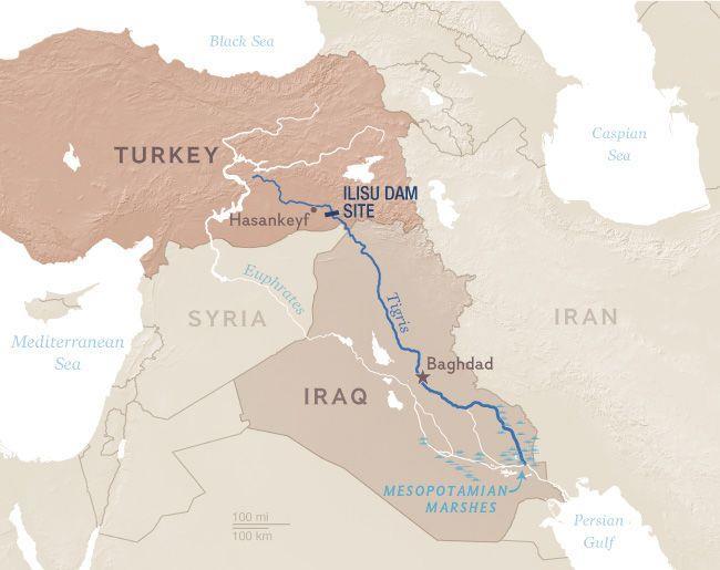
1 New Dam in Turkey Threatens to Flood Ancient City and Archaeological Sites Tigris River Dam puts wildlife and culture at risk, critics say. Julia Harte in Turkey for National Geographic PUBLISHED FEBRUARY 21, 2014 From the Neolithic caves riddling its cliffs to the honey-colored, 15th-century minarets looming over its streets, Hasankeyf, Turkey, is a living museum of epic proportion. Rare birds soar around the crumbling towers of its Artuqid bridge. Shepherds' songs have echoed through its canyons for centuries, even as the area transformed from a Byzantine bishopric to an Arab fortress to an outpost in the Ottoman Empire. Almost every major Mesopotamian civilization has occupied this 12,000-year-old settlement site on the banks of the Tigris River in southeastern Turkey, not far from the border with Syria.
2
3 NG STAFF But today's reigning power, the Turkish Republic, has a unique plan for Hasankeyf: submerging the ancient town beneath 200 feet (60 meters) of water. That will be the result of a hydroelectric dam now under construction in Ilısu village, 60 miles (97 kilometers) downstream from Hasankeyf. In February 2013, Turkey's highest administrative court ordered construction to halt until an environmental impact assessment had been carried out. "Then the Turkish government just changed the regulation so that the Ilısu Dam doesn't need an environmental impact assessment," says Dicle Tuba Kılıç, the Hasankeyf campaign coordinator for Turkey's Nature Foundation. The last major dam to be built under a regional development plan known as the Southeastern Anatolia Project, the Ilısu Dam will generate nearly 2 percent of Turkey's electricity supply, and create an 11-billion-cubic-meter reservoir. Turkish officials say it will open later this year. The dam joins a list of massive river-blockers that have submerged historic homes and cultural sites worldwide in the last century. During the 1950s, construction of Egypt's Aswan Dam to control the flooding of the Nile led to resettlements and the removal of monuments such as amassive statue of Ramses the Great. China's Three Gorges Dam on the Yangtze, completed in 2012, caused the relocation of 1.2 million people and the flooding of hundreds of archaeological sites. Brazil's Belo Monte Dam, now under construction, has triggered protests from indigenous people over its planned flooding of 250 square miles (650 square kilometers) of rain forest. The Ilısu Dam is also expected to reduce the flow of the Tigris into Syria and Iraq, possibly exacerbating a six-year drought that has crippled agriculture in southern Iraq, said Kılıç. Upstream, the reservoir will inundate 300 historical sites and displace more than 25,000 people in Turkish towns along the Tigris, she added.

4 PHOTOGRAPH BY JOHN WREFORD, DEMOTIX/CORBIS
5 The Tigris River winds through Hasankeyf; the town and its archaeological treasures will be flooded when a new dam is built. The Nexus of Energy and Culture Hasankeyf townsfolk understand their country's need for energy. "We aren't against the dam. But we want a dam that will leave Hasankeyf above the water," says Süleyman Ağalday, a local butcher. Like most of the town's residents, Ağalday is himself a memento of the area's diverse history: He's fluent in Kurdish, Turkish, and an Arabic dialect related to the Bedouin tongue spoken by his forebears. Only one-fifth of the archeological sites around Hasankeyf have been unearthed so far, and local archeologists predict that 85 percent of the remainder will be flooded before they can finish excavating.
6
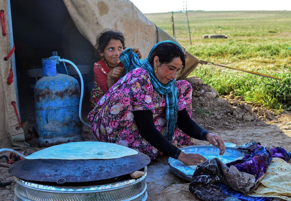
7 An Arab nomad girl and her mother bake bread in Iraqi Kurdistan. The nomads haul river water in tankers for themselves and their animals. In 2010, a team from Turkey's Middle East Technical University proposed an alternative plan to Ilısu: five smaller hydroelectric dams along the Tigris that would leave Hasankeyf completely above water. Government officials did not respond specifically to the proposal, but declared that all efforts would be made to preserve Hasankeyf's culture and history. The Ilısu Dam as planned is crucial to Turkey's future energy security, according to Ahmet Saatçi, director of Turkey's State Water Works, the government authority in charge of constructing the dam. "Turkey is suffering for energy sources," he says. "We currently have to buy our energy from Russia and other countries, so we're trying to use our renewable energy to its fullest extent." Doubts and Concerns So the government has built new houses for the villagers on a nearby hillside, and has promised that Hasankeyf's biggest monuments will be moved. "In the underwater area, we'll preserve some artifacts that can't be moved, and we'll create a center for tourism that can host diving activities and water sports," says Hasankeyf District Governor Ceyhun Dilşad Taşkın. "Hasankeyf will be transformed into a very modern city in the new settlement site." "New Hasankeyf" is located on arid, rocky soil that is a stark contrast to the fruit trees and fertile gardens that now fill the backyards of Hasankeyf homes. A three-bedroom house in the new site will cost 170,000 TL ($85,000), according to signs posted around the town, while residents' current homes have been valuated at one-eighth of that.
8
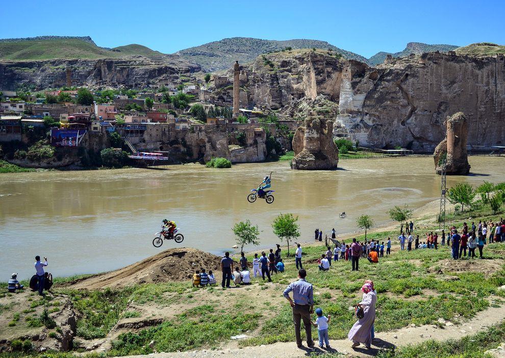
9 A motorcycle show in Hasankeyf was promoted as a nonhistorical attraction for tourists. Some residents, many of whom already rely on government subsidies, say they don't want to take the government loans they would need to afford the new houses. They say economic opportunities are scarce in this depressed region of Turkey, the site of a three-decade-long civil war between the Kurdistan Workers' Party (PKK) guerilla army and the Turkish state. So desperate are locals for jobs that even Hasankeyf villagers who oppose the dam have helped build it. Murat Sevinç worked at the site from 2010 to "If there weren't so few job opportunities [here], nobody would want to work on something that was going to submerge his home under water," he says. "I don't want my city, my village, to be lost for a project that will last 50 years." Sevinç said he has doubts about the stability of the concrete casing around the dam, and suggested that too much water was mixed into it. The Ilısu Dam's project manager, Mahmut Dundar, refused repeated requests for interviews, saying he could not get permission from his superiors at Turkey's State Water Works to comment on the construction. Regional Water Politics Heat Up Downstream countries have their own concerns about Ilısu and Turkey's other planned dams. In Iraq, "there are thousands of water refugees every year," says Bakhtiar Amin, former human rights minister of Iraq. "Many villages are depopulated because of this." Turkey claims to release 500 cubic meters of river water downstream each second from its dams, but Amin says the actual amount is closer to 200 cubic meters per second.
10
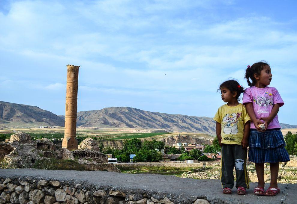
11 Children overlook the Sultan Suleyman mosque in Hasankeyf; some argue that tourism could be boosted if the town's historical sites were promoted. Iraq and Syria have built their own big dams on the Tigris and Euphrates Rivers. But Turkey's dams dominate the rivers, especially the Euphrates. When the 27-billion-cubic-meter-capacity Atatürk Dam opened on that river in 1990, it reduced the mighty waterway to a trickle for one month. In the Mesopotamian marshes of southern Iraq, which once covered one-fifth of modern Iraq's landmass and which have hosted human civilization since ancient Sumer, the flow of the Euphrates is now sometimes as low as 18 cubic meters per second, compared with the 90 cubic meters per second required to sustain the local population of Marsh Arabs, according to Jassim Al-Asadi, a local director for the nongovernmental organization Nature Iraq. "There won't be any more marsh in Iraq" if Ilısu and the other remaining dams in Turkey's Southeastern Anatolia Project are built, says Al-Asadi. Iraqi officials estimate that the project will dehydrate 670,000 hectares of arable land in the country. Al-Asadi was born amidst the reeds of the majestic marshlands. As a child, he would paddle in a traditional wooden boat to school, where birds, fish, and snakes wandered through his reed-hut classroom during the flood season. But the Tigris and Euphrates Rivers are now so low that salty water from the Persian Gulf has rushed in. This has raised river salinity to levels that are unhealthy for marsh wildlife, not to mention the Marsh Arabs, who now buy tanks of potable water in nearby towns and ferry them back to their homes in the marsh. Agriculture around Iraq's marshes is also suffering from the lower river levels, causing mass urban migration and dozens of conflicts each year. One sheikh estimated that water scarcity caused 20 murders in his province in Near Nasiriyah Province, where a 52-year-old farmer recently shot himself in the head after his farm's stream dried up completely, Salim Mihsin Saeed has a small fruit and vegetable farm that doesn't get enough water despite Saeed's high-efficiency drip irrigation system. "This land used to be a marsh, but the water constructions in Turkey affected our whole country's water quality and quantity," he said last May, gesturing at his tiny tomato plants poking out of the parched earth. He isn't sure whether his farm will survive the next big Turkish dam. On a larger scale, no one can predict exactly how much social upheaval the Ilısu Dam will cause. But as its construction draws to a close, people across modern Mesopotamia are anxiously waiting to see. Julia Harte's trip was supported by a Young Explorer grant from the National Geographic Expeditions Council and a Dick Goldensohn Fund grant from the Center for Investigative Reporting.
Unit 9 The Middle East SG 1 - Physical Geography, Population & Demographics
 Unit 9 The Middle East SG 1 - Physical Geography, Population & Demographics I. Physical Geography A. The Middle East includes southwestern Asia and North Africa. 1. The name is Eurocentric. Middle East
Module 1 Educator s Guide: Representative Discussion Points Investigation 3
 Module 1 Educator s Guide: Representative Discussion Points Investigation 3 Ethiopia and Eritrea Our combined population is 59,578,171 people. We have just emerged from a long period of civil war and famine.
New Chinese Dam Project Fuels Ethnic Conflict in Sudan
 New Chinese Dam Project Fuels Ethnic Conflict in Sudan Thu, 01/20/2011-6:15pm By: Peter Bosshard Protest against the Kajbar Dam in Sudan Dams have impoverished tens of thousands of people and triggered
Chapter 17. North Africa, Southwest Asia and Central Asia
 Chapter 17 North Africa, Southwest Asia and Central Asia Chapter Objectives Describe the major landforms and natural resources of North Africa, Southwest Asia, and Central Asia. Discuss the climate and
Middle East Part I Notes
 Middle East Part I Notes What do we already know about the Middle East? What do we already know about the Middle East? Pre-Test 1. T/F- The U.S. is currently fighting a war in the Middle East. 2. Which
North Africa. Chapter 25. Chapter 25, Section
 Chapter 25, Section World Geography Chapter 25 North Africa Copyright 2003 by Pearson Education, Inc., publishing as Prentice Hall, Upper Saddle River, NJ. All rights reserved. Chapter 25, Section World
Chapter 16 ~ Eastern Mediterranean
 Chapter 16 ~ Eastern Mediterranean Physical Geography of the Eastern Mediterranean Landforms This area is known as the Levant and includes Syria, Jordan, Lebanon, Israel, and the Palestinian territories.
STUDY GUIDE. The Land. Chapter 17, Section 1. There are frequent earthquakes in the region. Petroleum is a major export in the region.
 For use with textbook pages 421 426. The Land Terms to Know alluvial soil A rich soil made up of sand and mud deposited by flowing water (page 423) wadi A streambed that remains dry until a heavy rain
The Nile Valley For use with pages 38 46
 READING ESSENTIALS AND STUDY GUIDE 2-1 The Nile Valley For use with pages 38 46 Key Terms cataract: spot of rapid waters in a river (page 39) delta: area of fertile soil at a river s end (page 39) papyrus:
Essential Standards: WH.H.2 Analyze ancient civilization and empires in terms of their development, growth and lasting impact.
 Unit: Ancient Civilizations Topic: The Nile River Valley Essential Standards: WH.H.2 Analyze ancient civilization and empires in terms of their development, growth and lasting impact. Clarifying Objectives:
Chapter 16 ~ Eastern Mediterranean
 Chapter 16 ~ Eastern Mediterranean Physical Geography of the Eastern Mediterranean Landforms This area is known as the Levant and includes Syria, Jordan, Lebanon, Israel, and the Palestinian territories.
WATER MAY BE NEXT FLASHPOINT IN MIDEAST (Senate - March 26, 1992) [Page: S4417] [Page: S4416]
![WATER MAY BE NEXT FLASHPOINT IN MIDEAST (Senate - March 26, 1992) [Page: S4417] [Page: S4416]](/thumbs/78/78275515.jpg "WATER MAY BE NEXT FLASHPOINT IN MIDEAST (Senate - March 26, 1992) [Page: S4417] [Page: S4416]") 1 of 6 5/13/2008 12:22 PM WATER MAY BE NEXT FLASHPOINT IN MIDEAST (Senate - March 26, 1992) [Begin insert] [Page: S4417] [Page: S4416] Mr. SIMON. Mr. President, one of the policy areas where we have paid
1 of 6 5/13/2008 12:22 PM WATER MAY BE NEXT FLASHPOINT IN MIDEAST (Senate - March 26, 1992) [Begin insert] [Page: S4417] [Page: S4416] Mr. SIMON. Mr. President, one of the policy areas where we have paid
TURKEY AND WATER RESOURCES MANAGEMENT By Heather Cross
 TURKEY AND WATER RESOURCES MANAGEMENT By International Perspectives in Water Resources Management Summer 2005 Executive Summary Turkey is located in the Middle East near Syria and Iraq. It is the only
Egypt. shall no longer be a prince from the land of Egypt.
 Egypt The Evidence You decide When Egypt is mentioned, most of us will think of the pyramids. Tourists visit Egypt to look at ruins of magnificent temples found there. These monuments are all reminders
Photo Documentation Activities and Milestones
 Photo Documentation Activities and Milestones 1993-2014 1993 WWF Danube campaign Save the Danube floodplains. With Prince Phillip, president of WWF International at the time, at the Danube in Hainburg.
Concept Document towards the Dead Sea Basin Biosphere Reserve and World Heritage Listing. This report has been presented to the public and to
 Concept Document towards the Dead Sea Basin Biosphere Reserve and World Heritage Listing. This report has been presented to the public and to political decision makers both regionally and internationally
Petra, The World wonder
 City Tourism Petra, The World wonder ITM / Jordan Jordan s most valuable treasure and greatest tourist attraction. Al dier monastery petra gohoto The giant red mountains and vast mausoleums of a departed
Lesson Objectives. Core Content Objectives. Language Arts Objectives
 The Ancient Greeks 1 Lesson Objectives Core Content Objectives Students will: Identify the area of ancient Greece on a map Locate Crete, the Black Sea, the Aegean Sea, and the Mediterranean Sea on a map
the basic principle of justice in Hammurabi s Code ( an eye for an eye ). (H, C, E)
. (H, C, E)") SEPTEMBER OCTOBER NOVEMBER HUMAN ORIGINS IN AFRICA THROUGH THE NEOLITHIC AGE 7.1 Describe the great climatic and environmental changes that shaped the earth and eventually permitted the growth of human
SEPTEMBER OCTOBER NOVEMBER HUMAN ORIGINS IN AFRICA THROUGH THE NEOLITHIC AGE 7.1 Describe the great climatic and environmental changes that shaped the earth and eventually permitted the growth of human
What is pre-history? Time before writing. What is history? Written records
 What is pre-history? Time before writing What is history? Written records What are six main characteristics of a civilization? What are six main characteristics of a civilization? Growth of cities with
Chapter 7 Geography and the Early Settlement of Egypt, Kush, and Canaan
 Chapter 7 Geography and the Early Settlement of Egypt, Kush, and Canaan How did geography affect early settlement in Egypt, Kush, and Canaan? Section 7.1 - Introduction RF/NASA//Corbis This satellite photograph
General Introduction to Ancient Egypt
 Name Date Period General Introduction to Ancient Egypt The Geography of the Nile The Nile flows north from East Africa to the Mediterranean Sea. Along the way there are rough, rocky areas called cataracts.
A: Pre-reading Vocabulary
 - 1 - In this text you are going to read about Egypt and the Egyptian people. There are some words in this text that you won t see very often when you are reading but are important for this text. These
Unit 1: Physical Geography Notes
 - How has the physical world impacted settlement patterns? o Major factors in the decision-making process of o Before the boom controlling the physical environment was not possible on a large scale - Physical
North Africa and Southwest Asia. Economic Geography
 North Africa and Southwest Asia Economic Geography Natural Resources Oil is the major resource in this region. Many countries in this region are members of OPEC (Organization of Petroleum Exporting Countries).
What. Ancient Civilizations Early Civilizations Classical Civilizations History is personal
 What Ancient Civilizations Early Civilizations Classical Civilizations History is personal What are six main characteristics of a civilization? What are six main characteristics of a civilization? Growth
World History: Societies of the Past
 World History: Societies of the Past 1. What is history? History is the story of people from the past to present. It is when people study what happened in the past related with someone or something. History
Babylon. Ancient Cities by the River Lesson 5 page 1 of 6. Code of Hammurabi monument. E u p h. T i g r i s. r a t e s. Babylon, Mesopotamia
 Ancient Cities by the iver Lesson 5 page 1 of 6 1700s BCE, and established the importance of the city for the region He was responsible for a code of laws/decrees to reestablish justice in the land His
Ancient Middle East & Egypt (3200 B.C. 500 B.C. (pgs )
") Ancient Middle East & Egypt (3200 B.C. 500 B.C. (pgs. 26 55) Map orientation: Orientation to the location of the first civilizations A primary similarity between early civilizations was rivers why was
Ancient Middle East & Egypt (3200 B.C. 500 B.C. (pgs. 26 55) Map orientation: Orientation to the location of the first civilizations A primary similarity between early civilizations was rivers why was
Turkey 's border lands: Adventure, scenery and culture
 Turkey 's border lands: Adventure, scenery and culture ITM London City Tourism A world away from Turkey s popular resorts, the eastern borderlands offer adventure, scenery and cultural interest on a grand
Turkey Targets Archaeological Sites in Afrin
 Turkey Targets Archaeological Sites in Afrin Tourism and Protection of Relics Commission Aljazeera Region /http://desteya-shunwaran.com 2/2/2018 In Afrin region, there are hundreds of important archaeological
Rivers. Highlights of some of the World s Most Famous Rivers!
 Rivers Highlights of some of the World s Most Famous Rivers! Directions This Power Point presentation contains information about some of the most famous rivers in the world! Students should use this presentation
Lake Mead Learning Guide
 Lake Mead Learning Guide Author: Mary Beth Goff Editor: Karyn Travaglino Publisher: Road Trip Teacher, LLC by Mary Beth Goff Copyright 2015 Road Trip Teacher, LLC Pages may be copied for same household
Unit Two. Water on Earth
 CONTENTS Unit One People and Culture Lesson One: Family Traditions Lesson Two: Holidays and Celebrations Lesson Three: Taking Care of My Teeth Lesson Four: I Want to Be a Vet Lesson Five: Dairy Farmer
Chapter 7. Geography and the Early Settlement of Egypt, Kush, and Canaan
 Chapter 7 Geography and the Early Settlement of Egypt, Kush, and Canaan Chapter 7 Geography and the Early Settlement of Egypt, Kush, and Canaan How did geography affect early in Egypt Kush, and Canaan?
The Syrian Middle Euphrates Archaeological Project (PAMES).
.") The Syrian Middle Euphrates Archaeological Project (PAMES). Seven years of research (2005-2011) of the Spanish and Syrian Archaeological Mission in Deir ez-zor. With the support of Aïdi Foundation In September
The Syrian Middle Euphrates Archaeological Project (PAMES). Seven years of research (2005-2011) of the Spanish and Syrian Archaeological Mission in Deir ez-zor. With the support of Aïdi Foundation In September
Executive Summary. Background of the issue
 Executive Summary Thousands of villagers in risk of losing their homes to a lake formed by a landslide which could burst its banks within days, the possible massive flood could affect more than 50,000
The Nile & Ancient Egyptian Civilization
 The Nile & Ancient Egyptian Civilization Blessings of the Nile Every year, the Nile River flooded its banks and the surrounding people sang hymns to give thanks to the Nile for nourishing the land and
1: The Nile River Valley
 1: The Nile River Valley In Nubia and Egypt, the Nile flows through the Sahara, a vast desert that stretches across most of northern Africa. Before reaching Egypt, the river in ancient times roared through
Chapter 25 Section One: Istanbul: A Primate City throughout History urban primate city
 Chapter 25 Section One: Istanbul: A Primate City throughout History Meryem lives in Istanbul, the largest city in Turkey. It is early morning. She is riding a ferryboat to get to work. The ferry carries
Unit 6 vocabulary. Serengeti Plain
 basin Nile River rift valley Mount Kilimanjaro escarpment Sahara aquifer oasis Serengeti Plain canopy Niger delta Sahel the world s longest river, flowing more than 4,000 miles through Uganda and Sudan
Ancient Egypt. Life Along the Nile River
 Ancient Egypt Life Along the Nile River 2018 Geography How Does Geography affect the way that people live? Geography- Where in the World? You are Here Streetsboro, Ohio United States of America Geography-
Mediterranean Sea Persian Gulf Red Sea Tigris River Euphrates River Sumer Fertile Crescent
 GEOGRAPHY MESOPOTAMIA MAP Mediterranean Sea Persian Gulf Red Sea Tigris River Euphrates River Sumer Fertile Crescent ACHIEVEMENT INTELLECT RELIGION POLITICS SOCIETY ECONOMY N Fertile Crescent - lots of
People of the Nile 5. Lesson Objectives. Core Content Objectives. Language Arts Objectives
 People of the Nile 5 Lesson Objectives Core Content Objectives Students will: Locate Egypt on a world map or globe and identify it as a part of Africa Explain the importance of the Nile River and how its
absolute building land water
 Site and Situation What makes a city great? Why are some cities better than others? Cities developed for a variety of reasons. Site and situation are important geographic concepts when studying the reasons
Ancient Egypt and the Near East
 *O*»f ' i ft Ancient Egypt and the Near East Chapter 7 Chapter 8 Chapter 9 Geography and the Early Settlement of Egypt, Kush, and Canaan The Ancient Egyptian P h a r a o h s Daily Life in Ancient Egypt
South Africa: Drought leads to failed crops, water shortages 10 January 2016, bylynsey Chutel
 South Africa: Drought leads to failed crops, water shortages 10 January 2016, bylynsey Chutel In this Thursday Jan. 7, 2016 photo, an elderly woman drinks water from a bucket after waiting for hours for
Merowe Dam Archaeological Salvage Project (MDASP)
") Merowe Dam Archaeological Salvage Project (MDASP) Salah Mohamed Ahmed Introduction The idea of building a dam at the 4 th Cataract of the Nile dates to the period of the Anglo-Egyptian administration in
Merowe Dam Archaeological Salvage Project (MDASP) Salah Mohamed Ahmed Introduction The idea of building a dam at the 4 th Cataract of the Nile dates to the period of the Anglo-Egyptian administration in
Brazil. Chapter 12. Chapter 12, Section
 Chapter 12, Section World Geography Chapter 12 Brazil Copyright 2003 by Pearson Education, Inc., publishing as Prentice Hall, Upper Saddle River, NJ. All rights reserved. Chapter 12, Section World Geography
oi.uchicago.edu Over a span of more than two decades, Oriental Institute expeditions have worked within the ruins of the ancient city of Nippur.
 oi.uchicago.edu Bedouin on Nippur mound Reconnaissance and Soundings in the Nippur Area ROBERT M C C. ADAMS, Field Director Over a span of more than two decades, Oriental Institute expeditions have worked
Nicaragua versus Costa Rica?
 Nicaragua versus Costa Rica? Overview: Today I want to look at Nicaragua versus Costa Rica from both a destination for retiree s standpoint and for potential investment interest. First I'll provide some
THE GEOGRAPHY OF THE NILE. Section 1
 THE GEOGRAPHY OF THE NILE Section 1 The Nile River is the world s longest river. It flows north from its sources in East Africa to the Mediterranean Sea for more than 4,000 miles. THE COURSE OF THE NILE
Chapter 4 : Ancient Egypt and Kush
 Chapter 4 : Ancient Egypt and Kush Chapter 4 Section 1 Geography and Ancient Egypt The Nile River is the most important thing in Egypt. The Nile is the longest river in the world. It stretches about 4000
UNIT 5 AFRICA PHYSICAL GEOGRAPHY SG 1 - PART II
 UNIT 5 AFRICA PHYSICAL GEOGRAPHY SG 1 - PART II III. CLIMATE & VEGETATION A. The four main climate zones are tropical wet, tropical wet/dry (split into monsoon & savanna), semiarid, and arid. Other climate
Brief Description of Northern the West Bank, Palestine Prepared by: Dr. Ahmed Ghodieh Department of Geography An-Najah National University Nablus,
 Brief Description of Northern the West Bank, Palestine Prepared by: Dr. Ahmed Ghodieh Department of Geography An-Najah National University Nablus, Palestine Brief Description of Northern the West Bank
World Wonders. Introduction. Barnaby Newbolt STAGE. Chapter summary
 STAGE Barnaby Newbolt Introduction This ungraded summary is for the teacher s use only and should not be given to students. Chapter summary Chapter 1 (A world of wonders) introduces the idea of wonders.
ì<(sk$m)=bdicij< +^-Ä-U-Ä-U
=bdicij< +^-Ä-U-Ä-U") Genre Comprehension Skill Text Features Science Content Nonfiction Compare and Contrast Captions Diagrams Rocks and Soil Labels Glossary Scott Foresman Science 3.7 ì
Genre Comprehension Skill Text Features Science Content Nonfiction Compare and Contrast Captions Diagrams Rocks and Soil Labels Glossary Scott Foresman Science 3.7 ì
The Pearl of Africa: A Survey of Uganda's National Parks
 The Pearl of Africa: A Survey of Uganda's National Parks June 24, 2015 Uganda's natural beauty has hardly escaped notice. In 1909, Sir Winston Churchill famously called it the Pearl of Africa, a sentiment
OmanJerzy Wierzbicki. Paweł Pyrka Jagodziński
 D I S C O V E R OmanJerzy Wierzbicki Paweł Pyrka Jagodziński INTRODUCTION I have travelled around the Middle East continuously since 1999. It was my passion since early years of my youth, when I read many
Ethiopia s massive new dam threatens Egypt s Nile River
 Ethiopia s massive new dam threatens Egypt s Nile River Ethiopia s massive new dam threatens Egypt s Nile River Internation <img alt= The Grand Ethiopian Renaissance Dam under construction in 2017 (courtesy
The Rise of Civilization. Ancient Egypt
 The Rise of Civilization Ancient Egypt Geography The Egyptian civilization was located in Egypt in North Africa. The Egyptian empire was located on the lower deltas of the Nile River. The Egyptians lived
The Vjosa River in Albania
 The Vjosa River in Albania Europe s Wild jewel - beautiful, unknown and threatened The extensive braided river section near Tepelena would drown in a reservoir of the future Kalivaç dam. (Romy Durst) Major
Egypt: The Nubia Museum, Aswan, Egypt. The Nubia Museum. Location: Aswan, Egypt. How to get there: 1 / 5
 The Nubia Museum Location: Aswan, Egypt How to get there: 1 / 5 International flights direct to Aswan, or via many European and Eastern European cities. Also package tours and charter flights. Contact
Ancient Egypt: an Overview
 Ancient Egypt: an Overview Timeline Old Kingdom Middle Kingdom 2650 BC 2134 BC 2125 BC 1550 BC New Kingdom 1550 BC 1295 BC http://www.thebanmappingproject.com/resources/timeline.html 1 Three Kingdoms of
Vocabulary Words. predict inundation deity afterlife. mummy cataract nation-state dynasty
 The Gift of Nile Vocabulary Words predict inundation deity afterlife mummy cataract nation-state dynasty Predict Predict: To tell ahead of time what will happen. Inundation Inundation; Annual flooding
THE PREHISTORIC AEGEAN AP ART HISTORY CHAPTER 4
 THE PREHISTORIC AEGEAN AP ART HISTORY CHAPTER 4 INSTRUCTIONAL OBJECTIVES: Students will be able to understand the environmental, technological, political, and cultural factors that led societies in the
Albania Official name: Total area Urban-rural population Form of government Urban Rural:
 Albania Official name: Republika e Shqipërisë (Republic of Albania) Form of government: unitary multiparty republic with one legislative house President: Ilir Meta Prime Minister: Edi Rama Capital: Tirana
Passwords. Social Studies Vocabulary. Ancient Civilizations
 Passwords Social Studies Vocabulary Ancient Civilizations To the Student What is an epic? Is it bad if a tyrant takes over a country? What does an astronomer do? Passwords: Social Studies Vocabulary will
LOCATION, CLIMATE, AND NATURAL RESOURCES OF MEXICO
 SS6G3 The student will explain the impact of location, climate, distribution of natural resources, and population distribution on Latin America and the Caribbean. a. Compare how the location, climate,
CLASSICAL TURKEY 10 days
 10 days Countries visited Turkey Tour Highlights Admire the stunning Blue Mosque Learn about life in Ottoman times in Topkapi Palace Appreciate the genius in the design of Hagha Sophia Experience the Grand
COUNTRY CASE STUDIES: OVERVIEW
 APPENDIX C: COUNTRY CASE STUDIES: OVERVIEW The countries selected as cases for this evaluation include some of the Bank Group s oldest (Brazil and India) and largest clients in terms of both territory
The Ancient Egyptians
 The Ancient Egyptians Geography of Ancient Egypt Religion In Ancient Egypt Ancient Egyptian Society The Geography of Ancient Egypt Nile River Giver of Life Longest river in the world @ 4200 miles Protected
We treat you like Royalty
 Jordan Road Travel & Tourism Beauty of Jordan tour 5 Days / 4 Nights We treat you like Royalty Itinerary Day 1 Amman Airport - Amman Upon arrival you will be assisted by our representative and transferred
Chapter 7: The Geography and Settlement of Egypt, Kush, and Canaan
 Chapter 7: The Geography and Settlement of Egypt, Kush, and Canaan Learning Target: I can explain how geography affected early settlement in Egypt, Kush, and Canaan. Ancient Egypt and the Middle East Can
Egypt and the Nile River Valley System. SC Standards 6-1.3, 1.4, 1.5
 Egypt and the Nile River Valley System SC Standards 6-1.3, 1.4, 1.5 Where is Egypt? Egypt is on the continent of Africa. The River Nile runs through Egypt The capital of Egypt is Cairo Where is Egypt?
Annex III: Statistics
 Annex III: Statistics Table A.3.1 Physical characteristics of Arab countries Country Area, 2011 (thousand square kilometres) Length of coast, 2005 (kilometres) Rainfall, 2002 (millimetres per year) Total
Development of African Agriculture
 Development of African Agriculture Sahara desert originally highly fertile region Western Sudan region nomadic herders, c. 9000 BCE Domestication of cattle c. 7500 BCE Later, cultivation of sorghum, yams,
CST SABE A.A. 2018/19 HISTORY OF ARCHITECTURE_I ANCIENT MESOPOTAMIA. Dr. Manlio MICHIELETTO ARCH1162_HISTORY OF ARCHITECTURE I
 CST SABE A.A. 2018/19 HISTORY OF ARCHITECTURE_I Dr. Manlio MICHIELETTO 1 Column base, Basilique Notre-Dame de la Paix, 1986 2 INDEX 1. Geography 04 05 3 1. Geography 4 1. Geography 5 2. (Pre)History Architecture
John Groesbeck Ryan Umina Neil Mudjer Dan Armgardt
 John Groesbeck Ryan Umina Neil Mudjer Dan Armgardt Themes Politics Social-Economic Impact Future Damming and Implications Uses of Dams Water Supply Navigation Hydropower Stabilize Water Flow Irrigation
Republic of Turkey - Ministry of Economy,
 Republic of Turkey - Ministry of Economy, 2012 0 SHIPBUILDING INDUSTRY Turkey is surrounded by sea on three sides, is a natural bridge between Asia and Europe. Turkey borders the Black Sea, the Mediterranean,
Cyprus and Greece. We spent time enjoying the views over the sea and slowly strolled back to the hotel to complete our introductory day.
 Cyprus and Greece We are traveling again, this time spending two weeks in the Eastern Mediterranean, first in Cyprus and then in Greece. We have visited both countries before but it has been about 20 years
Egypt Notes. What have I learned? Label the Delta, Upper Egypt, Lower Egypt, Mediterranean Sea
 Egypt Notes The Nile Waterfalls/rapids which impede travel up the Nile are called cataracts. What have I learned? Label the Delta, Upper Egypt, Lower Egypt, Mediterranean Sea The Nile is unique because
SS7G1 The student will locate selected features of Africa.
 Standards SS7G1 The student will locate selected features of Africa. a. Locate on a world and regional political-physical map: the Sahara, Sahel, savanna, tropical rain forest, Congo River, Niger River,
FOREIGN GOVERNMENT SUBSIDIES HURT AMERICA.
 AMERICA S AIRLINES UNDER THREAT. FOREIGN GOVERNMENT SUBSIDIES HURT AMERICA. When governments and royal families of the United Arab Emirates and Qatar violated their Open Skies promise to the U.S. and gave
Explore ancient. Egypt! carmella van vleet Illustrated by Alex kim
 Explore ancient Egypt! carmella van vleet Illustrated by Alex kim Contents 1 Introduction Let s Explore Egypt! 11 chapter 1 Egyptian Homes 21 chapter 2 Beer, Bread & Bartering chapter 3 34 Playtime 46
Map 1.1 Wenatchee Watershed Land Ownership
 Map 1.1 Wenatchee Watershed Land Ownership Map 1.1 Wenatchee Watershed Land Ownership The Wenatchee watershed lies in the heart of Washington state in Chelan County. Just larger than the state of Rhode
08D 07N South EASTERN ANATOLIA TOUR DETAILS
 08D 07N South EASTERN ANATOLIA TOUR DETAILS DAY 1// // Arrival to Mardin & Overnight in Mardin Arrival to Istanbul Airport or Mardin Airport Depends on your flight if it is landing we will match your international
Physical characteristics and biomes:
 Physical characteristics and biomes: Sahel region, bordering Sahara Characteristics Area suffers from lack of rainfall, over grazing, which causes loss of vegetation and loss of inhabitable areas causing
Skyland Ranch. At a Glance: Property Features
 Property Features Ideally positioned in an ox box of the mighty Apalachicola River, Skyland Ranch s 2 ½ miles of river frontage form the foundation of this distinctive property. Coveted by recreational
Sivec Marble - Description
 Sivec Marble - Description SIVEC WHITE is the commercial name for a fine-grained white dolomitic marble, which is quarried in the area of Prilep, F.YR.O.M. Sivec is a famous material that is known from
How the Nile River Led to Civilization in Ancient Egypt
 How the Nile River Led to Civilization in Ancient Egypt By USHistory.org, adapted by Newsela staff on 03.07.17 Word Count 786 Level 950L TOP: This photo, taken around 1915, shows the flooding of the Nile
TH E FIRST SEASON of investigations at the
 QUSEIR AL-QADIM Janet H. Johnson & Donald Whitcomb TH E FIRST SEASON of investigations at the ancient port of Quseir al-qadim on the Red Sea in Egypt took place in winter, 1978; the investigations were
6th Grade Social Studies Chapter 7: The Geography and Early Settlement of Egypt, Kush and Canaan
 I. Introduction (7.1) A. Egyptians settled along the Nile River, in the NE corner of Africa B. civilization lasted from around 3100 B.C. to 350 C. E. C. Kushites settled to the south of Egypt, along the
2.1 What is the climate like?
 José Medeiros This fact sheet allows you to see how varied the countryside is across Brazil. 2.1 What is the climate like? Most of Brazil is in the Southern Hemisphere, where the seasons are the opposite
THE ARCHAEOLOGY OF LIFE AT THE AMERICAN COMPANY MILL VILLIAGE AND THE VALUE OF LOCAL VOLUNTEERS
 THE ARCHAEOLOGY OF LIFE AT THE AMERICAN COMPANY MILL VILLIAGE AND THE VALUE OF LOCAL VOLUNTEERS :'". " RESEARCH CONTRIBUTION 104 lid 2001 by Chicora Foundation. Inc. All rights reserved. No part of this
Demographic Facts & Figures
 Lebanon Lebanon Map Demographic Facts & Figures Facts & Figures Capital Beirut Government Type Republic President Tammam Salam (2014) Currency LBP (Lebanese Pound) Population 58,82,562 (2014), Growth Rate:
How the Nile River Led to Civilization in Ancient Egypt
 How the Nile River Led to Civilization in Ancient Egypt By USHistory.org on 03.07.17 Word Count 1,108 Level MAX TOP: This photo, taken around 1915, shows the flooding of the Nile River, which happens each
5. What do you notice about population distribution and settlement location in Ancient Egypt? List three or four reasons for this.
 Document A Source: Map created from various sources. Egypt circa 1500 BCE Mediterranean Sea 1. The Nile is the world's longest river, 4,160 miles. Consider the southern boundary of Ancient Egypt to be
ì<(sk$m)=beicea< +^-Ä-U-Ä-U
=beicea< +^-Ä-U-Ä-U") Fascinating Facts The Nile River in Egypt is the world s longest river, but the Amazon River in Brazil moves the most water. The world s largest freshwater lake is Lake Baikal in Russia. The highest temperature
Fascinating Facts The Nile River in Egypt is the world s longest river, but the Amazon River in Brazil moves the most water. The world s largest freshwater lake is Lake Baikal in Russia. The highest temperature
The Amity Easter Tour Beijing & Shaanxi, April 12-19
 The Amity Easter Tour 2013 Beijing & Shaanxi, April 12-19 Shaanxi Province Located in the very heart of China s territory, Shaanxi Province has an area of 205,600 square kilometers, about the size of England