Appendix A Footnote Reference Materials. 10 Things to Know About Urban vs. Rural Missouri Census Data Center 1
|
|
|
- Alvin Daniel
- 5 years ago
- Views:
Transcription
1 Appendix A Footnote Reference Materials 10 Things to Know About Urban vs Rural Missouri Census Data Center 1 Is America becoming more urban? What portion of the population is now living in an urban (vs rural) setting? With all the debates and discussions related to urban sprawl, do we have a way of defining and measuring where and to what extent that phenomenon is taking place? The answers to all of these questions require that we have an agreed upon definition of what it means to be "urban" (or rural, since we presume the two categories to be mutually exclusive and exhaustive, ie that every person and piece of land in the nation can be assigned to exactly one category or the other) This page will look at the latest official Census Bureau definitions of urban and rural and will identify resources for determining to what degree various geographic areas are classified as being one or the other We shall also look at how and where to get census and other data that can help us see what differences there may be between the two area types (in terms of how many people, age distributions, income and poverty levels, etc), and perhaps more importantly, what trends do we see related to them It may seem obvious in many cases: central cities are clearly urban, while most farms -- real ones, at least -- are clearly rural But there is more and more development in places sometimes referred to as "exurbia, and in fringe areas located within or adjacent to smaller cities, where the urban/rural classification is much less obvious Because the definition of this concept is so important, we as a nation feel obligated to keep trying to improve it This is no doubt a good thing for the sake of having a better measure of what is going on just recently, but it creates problems trying to analyze trends when the definition changes over time The current definition of Urban (which is also the definition of rural, since the two are complementary) went into effect with the 2000 decennial census, and is based upon population density data collected in that census Unless otherwise noted, all references to urban vs rural in this document will be using this definition 1 Urban vs rural is assigned at the Census Block level Census blocks are the smallest geographic units that the Census Bureau recognizes in its geographic scheme All other geographic areas used in census products can be defined as a collection of (usually, but not always, contiguous) census blocks Any other kind of geographic area -- a city, county, school district, ZIP code, etc -- will not necessarily be classified as completely urban or rural For example, Jackson County, Mo is the core county of the Kansas City metropolitan area and would seem to be obviously an "urban county But according to the 2000 census there were over 26,000 persons (4%) in Jackson county who were living in census blocks classified as rural Even within the city limits of Kansas City, Mo 13% of the population was classified as living in a rural setting If you look at the breakout based on land area instead of population you find that 433% of the land area of the city of Kansas City is classified as rural! (Anyone who has had occasion to use the Kansas City airport, which is over 20 miles from downtown Kansas City and in a very rural setting but is within the city limits, will not be surprised by this statistic) 1 Missouri Census Data Center
2 2 There are no counties in Missouri that are 100% urban, except the independent city of St Louis Of the 114 other counties in the state, only 33 are classified as being entirely rural 3 974% of the land area in the state of Missouri is classified as rural (per the 2000 Census) But only 306% of the population is classified as living in rural areas Thus, almost 70% of the population of the state lives in about 26% of the land Nationwide, the same 974% of the land area is classified as rural, but only about 21% of the population lives in these rural areas 4 MABLE/Geocorr can be used to see U/R breakdowns This utility application has "Urban-Rural portion (2000)" as a choice on its Source/Target geography menus Just select your state, select the geographic layer(s) of interest off the Source Geocode(s) menu and choose U/R off the Target Geocode(s) menu Choose your weighting variable as either population (default) or land area All of the statistics quoted above regarding what portions of the population and land areas of various geographic entities were generated using MABLE/Geocorr 5 The short definition of Urban and Rural It appears on a Census Bureau web page and is as follows: For Census 2000, the Census Bureau classifies as "urban" all territory, population, and housing units located within an urbanized area (UA) or an urban cluster (UC) It delineates UA and UC boundaries to encompass densely settled territory, which consists of: o Core census block groups or blocks that have a population density of at least 1,000 people per square mile and o Surrounding census blocks that have an overall density of at least 500 people per square mile In addition, under certain conditions, less densely settled territory may be part of each UA or UC The Census Bureau's classification of "rural" consists of all territory, population, and housing units located outside of UAs and UCs The rural component contains both place and nonplace territory Geographic entities, such as census tracts, counties, metropolitan areas, and the territory outside metropolitan areas, often are "split" between urban and rural territory, and the population and housing units they contain often are partly classified as urban and partly classified as rural 6 Urban is sometimes confused with "metropolitan" or, more recently, "micropolitan, which is just metropolitan on a smaller scale But the two concepts are significantly different Metro and Micropolitan areas are comprised of complete counties; counties on the outer fringes of metro areas ("exurbia") often have the majority of their land areas and significant portions of their populations classified as rural The metropolitan concept has more to do with whether you live in an area where you either within or have access to an urban center By having access we mean you can commute to work there (this is the primary criteria to being included in a metro area), access their TV and radio stations, subscribe to their newspapers, etc Urban/rural does not much care about how far away from an urban center you are It has much more to do with the density of the population in the immediate area around where you live While 306% of Missouri's population was classified as living in a rural area in the 2000 census, only about 14% lived outside of any metropolitan or micropolitan area (728% lived in metropolitan areas and 132% in micropolitan areas) Notice the implication of these figures: over 3/4 of the rural population is also metropolitan Nationwide we see that only about 25% of the rural population (about 146 million persons) lives outside of a metro area About 51% live in metropolitan statistical areas and 24% in micropolitan statistical areas
3 We have seen web sites ( just to cite an example), where the definition of Rural is presented as outside of an MSA (Metropolitan Statistical Area) While agencies may find it convenient to use such definitions and while there may be some merit and logic associated with these alternate definitions, it is important to keep in mind that these are not the official definitions and their widespread use just contributes to the confusion It does seem easier and a bit less geeky just to say "rural" instead of "Non-metro It may be okay until somebody wants to know how many people live in those "rural" areas 7 The previous definition of Urban used city limits instead of Urban Clusters While the details of how Urbanized Areas changed as part of the new Urban/Rural definition changes for 2000, the concept was pretty much the same Instead of a requirement for a place (city) of 50,000 or more to form the core of a UA, we now have a more sophisticated way of identifying densely settled population clusters of 50,000 or more So, for example, Jefferson City, MO did not qualify as an Urbanized Area in 1990 because the city had a population of just under 40,000 Under the new criteria, however, the area does qualify because it takes into account not just the population living within the city limits, but rather the entire densely settled area that includes most of the city The more important change in the urban/rural definition came in how areas outside of UA's were classified The new geographic entity involved is called an "Urban Cluster A UC is defined using the same concept as a UA, except that the central population threshold is lowered from 50,000 to 10,000 So, for example, we have a Poplar Bluff (MO) Micropolitan Area, because that city and its immediate environs has a population over 10,000 (but less than 50,000) This central cluster area has nothing to do with city boundaries, and everything to do with dense population settlement If you live on the outskirts of Poplar Bluff but are part of either the densely settled core or of the less densely settled adjacent area, then you are within the Urban Cluster -- and hence classified as Urban It has nothing to do with whether or not you live within any city limit Under the old definition, if you lived outside an Urbanized Area ("big city area") then you were classified as urban if and only if you lived within a place of 2,500 or more population That definition used to work pretty well, when people more or less lived "in town" or out in the "open country But not any more; people living in unincorporated areas adjacent to smaller towns (such as Poplar Bluff) are living in densely settled areas and should be classified as urban On the other hand, if you live in a small town of 2,500 or more that does not meet the criteria of having a 10,000-person population cluster associated with it, then you are now classified as rural instead of urban under the new definition 8 Accessing Census Data for Urban/Rural Components The Census Bureau publishes results of the decennial censuses and the American Community Survey for "Geographic Components" of geographic areas (usually, only vary large ones such as states, regions and the nation) A geographic component is something such as the urban or rural portion of an area, or the portion within metropolitan statistical areas or within urbanized areas, or within central cities of metropolitan areas, etc For example, on Summary File 3 for the 2000 Census - the most commonly used data product based on that census - there are geographic component summaries at the state level There are even more such summaries at the nation and US region levels The MCDC has found that when these geographic component summaries are intermixed with complete-geographic-area
4 summaries they can sometimes be a nuisance and cause confusion So we separated out the geographic component summaries and created datasets named usgeocomps in both our sf32000 and sf32000x (standard extract) filetype directories The codes for the urban and rural components (ie the values of the geocomp variable on the summary observations) are "01" and "43, respectively So (for those of you familiar with our Uexplore/Dexter system), to see summary data for the rural portion of Missouri, you would navigate (via uexplore) to the sf32000x subdirectory, and select the usgeocompssas7bdat file Within Dexter, you would filter based on the value of State (=29) and GeoComp (=43) You can also access summaries for such geographic components through American FactFinder For example, if you choose the AFF "Data Sets" option and then choose the 2000 Decennial Census and Summary File 3 and Detailed Tables with a geographic summary level of state or above, then after your output is displayed (I know, not too cool) they provide a little menu bar that lets you "change your results If you click on the "Options" pull-down you are presented with a "Geographic Components" choice Follow the menus and make your choices It's really pretty easy to generate tables for urban and rural portions of states and the nation Understand, what this means is that you can get all the other detailed tables, things such as income measures, poverty level tables, housing value medians and distributions, propensity to live in mobile homes, etc -- all this broken down not just by urban and rural but also by various subcategories of urban and rural, such as "Urban - in urbanized area - not in a central place" (which is what you might think of as "suburban") Of course, if all you are interested in is how many persons and/or households within an area are classified as being urban and rural, that can be readily accessed from tables on files such as SF3 In our standard extracts based on Summary File 3 data (filetype sf32000x) we include the variables urban, rural, InUAs (living in Urbanized Areas), InUCs (living in Urban Clusters), OnFarms (persons living on farms), UrbanHUs (urban housing units) and RuralHUs There are corresponding Pct variables for each of these items; eg PctUrban has the value of Urban as a percentage of the total population All of these items, are derived from tables on Summary File 3 The definitions can be viewed in the online metadata The data can be viewed within our standard sf3-based demographic profiles We did not include any urban/rural data on our standard extracts based on Summary File 1 in the 2000 census because, although the tech documentation told us the data would be avaiable in Tables P2 and H2, the reality was that when those files were released those tables were not ready yet because it took so long for the Bureau to do the GIS-based processing that would permit assigning values to those tables You can access those tables via American FactFinder, however Geographic Component summaries on census summary files is not new Such summaries have always been published by the Bureau, although the number of categories has increased Urban and Rural have always been the most important and widely accessed categories Keep in mind, however, that the definitions have changed over time so the data are not entirely comparable 9 Urban and Rural does not get updated in the ACS The American Community Survey provides us with summaries of larger geographic areas throughout the decade You might expect to be able to get geocomp summary data (see previous item) that would allow us to find out how many people now live in urban vs rural areas, and what their characteristics are You might especially think this because the Bureau does indeed publish geocomp summaries based on the ACS, and urban and rural are among the geographic component categories For example, I can go to AFF (American FactFinder), choose Data Sets, and ask to see data from the 2005 ACS for the state of Missouri I can
5 ask to see detailed table B01003 (Total Population) and have that table displayed ("Total" pop in the 2005 ACS is actually just total pop living in households, but that's a different discussion) One that table is displayed we can (as already mentioned, above) use the Options on the menu that appears above the output, and from that choose to see Geographic Components, including Urban and Rural From this I can determine that the Bureau is reporting 1,803,146 (+/- 16,836 using the MOE figure) living in households in rural portions of Missouri Unfortunately, this looks a little better than it really is How does the Bureau assign the urban vs rural characteristic to the ACS survey records? The answer is that they geocode the address of the survey respondent, attaching (among other things) the 2000 census block Then they assign the urban/rural code to the household/person based upon the code assigned to that census block as of 2000 Why not use the urban/rural code assigned to that block based on 2005 data? Because that data does not exist See item 4 in our Ten Things to Know about the American Community Survey Edition document The ACS is not about head counts, it is about characteristics of persons and households In order to define a census block as being urban or rural would require having a complete set of current block population counts which would then have to be used as input to the Bureau's very sophisticated GISbased program that examines complex density patterns in order to make the category assignments So, how am I to interpret the 1,803,146 persons in "rural areas"? If this number is higher than the comparable figure from the 2000 Census, does it mean that people are moving from urban to rural areas? If by "rural area" you mean an area that was classified as rural in 2000, based on 2000 data patterns, then the answer is probably yes But this does not (necessarily, or even probably) mean that we are abandoning urban settings to live in more rustic ones That may be what we wanted to do, but what happens when people from urban areas move to areas that used to be rural but that are adjacent to urban areas, those areas are converted from rural to urban It is just that we do not measure and recognize this conversion until after the next decennial census Of course, it is always possible that in some areas it may have gone the other way, that some blocks formerly classified as urban have now become rural But anyone who follows development patterns in the US knows that this sort of change is almost unheard of, barring a natural or man-made disaster Bottom line on this point is that the figures for the rural portions of states and the nation that come from the ACS are probably counting too many people as being rural, with the corresponding undercounting of the urban portions If you are studying urban sprawl and you want to use ACS data to look at how much land area has been converted from rural to urban as the result of sprawl, you should NOT be looking at the ACS geocomp summaries for Urban vs Rural 10 A Picture of Rural Population in Missouri This map shows you what we were talking about in Item 6, above Most of the rural population of Missouri (which is not at all an unusual state in terms of such things) lives in metropolitan or micropolitan areas The figure we cited above that less than 3% of the land area of Missouri was classified as urban can be seen in this map Although it does not display urban population explicitly, we know that it can only exist in an Urbanized Area or Urban Cluster
 are")
6 Urbanized Areas/Urban Clusters and Metropolitan/Micropolitan areas are very closely linked, with the UA/UC just being the densely settled core area of the metro/micro area Urban territories on this map are green areas with no black dots The St Louis and Kansas City core areas are by far the largest such areas in Missouri Most of the really dense clusters of black dots (rural population) are within the green areas, especially the dark green (Jefferson and Franklin counties just south and southwest of St Louis, for example) The biggest cluster of dots in a non-metro-micro (white on the map) area is in the Lake of the Ozarks region, an area inhabited by early retirees and others seeking to get away from the big city This area is only marginally classified as rural; with growth in the Osage Beach/Lake Ozark area this decade it is very likely that after the 2010 census we'll have a Lake of the Ozarks micropolitan area and Urban Cluster, which will result in a large portion of the area's population being reclassified as urban What many people think of when they think of a rural lifestyle is one where going "into town" involves a significant journey that may only happen maybe once a week or less But that is really not the case with a great majority of the rural population now (if you are looking for that group, the better category would be persons living in the white areas of the map -- ie, outside any Metro or Micropolitan area) The majority of the rural population today (in Missouri, at least) may have septic tanks and may not have access to city utilities and other services, but they do live within an easy drive of some population center, and the large majority, we suspect, have easy access to a Super WalMart Most do not live on farms (only
7 about 25% of Missouri's population lived on farms in 2000; that comes to about 1 of every 12 rural residents) Most live in areas that look very much like suburbs or in small towns like Hermann or Osage Beach (The latter small-town residents were actually classified as urban under the prior definition) The author acknowledges the valuable contribution of Lance Huntley, OSEDA, who produced the map in item 10 This file last modified Saturday December 16, 2006, 11:15:47
8 Missouri Population by County Charts 2 Figure 2 Missouri Population by County Top-Ten Largest Projected Numeric Increases 2000 through 2030 Numeric Increase Rank Percent Increase County St Charles Clay Greene Christian Boone Jefferson Jackson Cass Lincoln Jasper Population 30-Year Change Numeric Percent 283, , ,391 54, , , ,880 82,092 38, , , , , , , , , ,933 91, , , ,015 89,434 76,781 68,810 62,177 59,587 54,841 52,350 47, % 630% 372% 1414% 508% 314% 91% 668% 1344% 457% Figure 3 Missouri Population by County Top-Ten Largest Projected Numeric Decreases 2000 through 2030 Numeric Decrease Rank Percent Decrease County Population 30-Year ChanQe Numeric Percent St Louis New Madrid Dunklin Pemiscot Iron Linn Saline Chariton Gentry 1,016,300 19,760 33,155 20,047 10,697 13,754 23,756 8,438 6, ,817 12,554 28,765 16,447 7,494 10,696 21,140 6,172 4,759-59,483-7,206-4,390-3,600-3,203-3,058-2,616-2,266-2,102-59% -365% -132% -180% -299% -222% -110% -269% -306% Wayne 13,259 11,200-2, % 2 Missouri Office of Administration The Missouri Population Projections Population Trends
9 Figure 4 Missouri Population by County Top-Ten Largest Projected Percentage Increases 2000 through 2030 Percent Increase Rank Numeric Increase County Christian Lincoln Warren St Charles Webster Taney Cass Clay Platte Boone Population 30-Year Change Percent Numeric 54,285 38,944 24, ,893 31,045 39,703 82, ,006 73, , ,066 91,294 46, ,126 53,282 68, , , , , % 1344% 885% 758% 716% 714% 668% 630% 557% 508% 76,781 52,350 21, ,233 22,237 28,338 54, ,015 41'123 68,810 Figure 5 Missouri Population by County Top-Ten Largest Projected Percentage Decreases 2000 through 2030 Percent Decrease Rank Numeric Decrease County Population 30-Year Change Percent Numeric New Madrid Gentry Iron Chariton Holt Worth Linn Sullivan Pemiscot Atchison 19,760 6,861 10,697 8,438 5,351 2,382 13,754 7,219 20,047 6,431 12,554 4,759 7,494 6,172 4,094 1,826 10,696 5,822 16,447 5, % -306% -299% -269% -235% -233% -222% -194% -180% -179% -7,206-2,102-3,203-2,266-1, ,058-1,397-3,600-1,151


10 WHERE WE PLAY Iowa Mississippi River Trail s s 0 u R N A Illinois MRT Trail Status Green aagmanta are fully designated,signed and described In promotionalmaterial Yellow era Red segments may Include dangerous areas and routing problems Purple segments mark adjacent trails Kentucky Tennessee
11 Ozark Trail Sections The Ozark Trail is divided into 13 sections roughly between 10 to 40 miles in length Each section provides its own unique experience with deep Ozark woodlands, clear running streams and open glade areas for panoramic views of the surrounding landscapes A brief description of each section follows: Courtois Section: This 45-mile section has trailheads in the Huzzah Conservation Area, at Harmon Springs, on Highway 8 and at Hazel Creek All have limited parking The trail uses the western half of the Berryman loop trail The trail from Harmon Springs to Hazel Creek is popular with mountain bikers and equestrians Trail uses: Hiking, mountain biking and equestrian use Trace Creek Section: Located southwest of Potosi, the 26-mile section has trailheads at Hazel Creek campground and Highway A, both with limited parking The trail leads through dense forests into shaded hollows and across ridge tops Trail uses: Hiking, mountain biking and equestrian use Taum Sauk Section: The 35-mile stretch is considered one of the best trails in Missouri, taking hikers over ancient mountains with grand vistas, through glades, past the state s highest waterfall and highest point and to scenic shut-ins Trailheads are at Highway A, Johnson s Shut-Ins State Park, Taum Sauk Mountain State Park and Highway 21 Trail uses: Hiking only Marble Creek Section: This is a pleasant, 10-mile hike and an excellent mountain bike trip The trail, named after the colorful deposits of dolomite, leads users around Crane Lake Trailheads are at Crane Lake and Marble Creek campground Trail uses: Hiking, mountain biking and equestrian use Wappapello Section: This 35-mile section runs from Sam A Baker State Park to Lake Wappapello, ending at Hendrickson It follows the St Francis River for 15 miles through woodlands and bottoms Trailheads are located at Highway 143, Highway 34, Highway FF at Little Kake Creek and Highway O in Hendrickson Trail uses: Hiking, mountain biking and equestrian use Victory Section: Named for the old Victory School, the trail is 18 miles long and incorporates a portion of the Victory horse trail between Elsinore and Hendrickson Trailheads are located on Highway 172, at Wrangler, Upalika Pond, Walton Chapel and Brushy Creek Trail uses: Hiking, mountain biking and equestrian use Karkaghne Section: This 29-mile-long trail runs just below the ridge tops at its snakes from Oates to Highway 72, dipping into the valleys as it crosses the West Fork of the Black River The southern end of the trail has a spur to Grasshopper Hollow, a large fen complex Trailheads are on Highway J, at Sutton Bluff and at Blair Creek Trail uses: Hiking, mountain biking and equestrian use
12 Middle Fork Section: The 24-mile-long trail crosses many brooks and streams in the upper basin of the Middle Fork of the Black River The northern trailhead is on Highway DD, with another on Highway J Trail uses: Hiking, mountain biking and equestrian use Blair Creek Section: The trail runs for 26 miles, passing through the Roger Pryor Pioneer Backcountry on its way to the Current River at Owl s Bend It offers outstanding views from the bluffs over the river Trailheads are at Highway P and Owl s Bend Trail use: Hiking only Current River Section: The trail begins at the Current River and leads toward Stegall Mountain, offering 30 miles of outstanding scenery The features include a scenic shut-ins on Rocky Creek and mountaintop glades Trailheads are located at Owl s Bend, Powder Mill Ferry, Peck Ranch and Highway 60 Trail uses: Hiking only Between the Rivers Section: The trail runs 30 miles from Highway 60, winding through several small tributaries that feed the Current River It climbs onto a major ridge that divides the watersheds of the Current and Eleven Point rivers Trailheads are on Highway 60 and at the Sinking Creek lookout tower Trail uses: Hiking, mountain biking and equestrian use Eleven Point Section: Great views and a visit to the sparkling Eleven Point River make this 29- mile section a favorite Trailheads are at Greer Springs campground and McCormack Lake Trail uses: Hiking, mountain biking and equestrian use North Fork Section: This recently opened section is 27 miles long and leads into the Devil s Backbone Wilderness Area The trailheads are at Pomona, Highway CC and Devil s Backbone Trail uses: Hiking, mountain biking and equestrian use For more information on the Ozark Trail, including detailed maps and information on each section, visit ozarktrailcom
13 Missouri Natural Areas and Wild Areas 3 Missouri Natural Area State Park Location Acreage Babler Southwoods Hollow Babler State Park 17 acres Bennett Spring Hanging Fen Bennett Spring State Park 535 acres Big Oak Tree Big Oak Tree State Park 940 acres Big Sugar Creek Cuivre River State Park 56 acres Botkins Pine Woods Hawn State Park 30 acres Chariton River Hills (Bee Trace) Long Branch State Park 3844 acres Chariton River Hills (West Char) Long Branch State Park 444 acres Coakley Hollow Fen Lake of the Ozarks State Park 4 acres Coonville Creek St Francois State Park 49 acres Cordgrass Bottoms Pershing State Park 80 acres Des Moines River Ravines Battle of Athens State Historic Site 40 acres Elephant Rocks Elephant Rocks State Park 7 acres Elk River Breaks Woodland Big Sugar Creek State Park 1,613 acres George A Hamilton Forest Cuivre River State Park 40 acres Graham Cave Glades Graham Cave State Park 815 acres Grand Gulf* Grand Gulf State Park 60 acres Ha Ha Tonka Karst Ha Ha Tonka State Park 70 acres Ha Ha Tonka Oak Woodland Ha Ha Tonka State Park 953 acres Johnson's Shut-Ins Johnson's Shut-Ins State Park 180 acres JSI Dolomite Glade Johnson's Shut-Ins State Park 18 acres JSI Fen Johnson's Shut-Ins State Park 8 acres LaMotte Sandstone Barrens Hawn State Park 81 acres Lincoln Hills Cuivre River State Park 1,872 acres Locust Creek Pershing State Park 330 acres Meramec Mosaic Meramec State Park 831 acres Meramec Upland Forest Meramec State Park 461 acres Montauk Upland Forest Montauk State Park 40 acres Mudlick Mountain Sam A Baker State Park 1,370 acres Orchid Valley Hawn State Park 120 acres Oumessourit (including Van Meter Forest) Van Meter State Park 300 acres Pickle Creek Hawn State Park 58 acres Pin Oak Slough Knob Noster State Park 4 acres Regal Tallgrass Prairie (East Drywood, Hunkah, Tzi-Sho) Prairie State Park 3,646 acres Roaring River Cove Hardwoods Roaring River State Park 120 acres St Francois Mountains Taum Sauk Mountain State Park 5,428 acres Vancill Hollow Trail of Tears State Park 300 acres Vilander Bluff Onondaga Cave State Park 206 acres Washington State Park Hardwoods Washington State Park 68 acres *L-A-D Foundation owns Grand Gulf Natural Area, DNR manages the site Total 37 Natural Areas 19,85565 acres L-A-D Foundation 1 Natural Area 6000 acres TOTAL ACRES 19,91565 acres 3 Missouri State Parks
14
15 Missouri State Parks - Inventory of Facilities Group Marina/ Picnic Parte Name Bask: ElectJ1c EI W SIEIW Eq WI ADA camp Lodging 811 OWiing Fishing Boating Swtmmllg Trais Bi<lngTrails ATVTrais Picnic Sites Shelter Arrow Rock State Historic Site l/r n 0 Battle of Athens State Historic S te RA R 0 Battle of Carthaqe State Historic Site Battle of Island Mound State Historic Site Battle of Lexington State Historic Site n Benrett Spring State Park C/OT R/S CR p 0 Big Lake State Parte ta S? 4 C/OT 1\A L c o /P 0 Big Oak Tree State Park RA L n Big Sugar Creek State Parte 0 BolliQger Mill State Historic Site Boone's Uck State Historic Site I 0 Bothwell Lodge State Historic Site MB 0 Castlewood State Park R IE MB 0 Clark's Hill/Norton State Historic Site n Confederate Memorial State Historic Site l Crowder State Park L B IE MB 0/E Cuivre River State Park RA l/r 16 o/bpie 0 Current River State Park Deutschheim State Historic Site Dillard Mill State Historic Site 5 Dr Edmund ABabler MemorialState Pari< IE HS 0 0 Edward "Ted" and Pat Jones-Confluence Point State Park Elephant Rocks State Pari< L I Felix Valle House State Historic Site Finger Lakes State Park RA 8 MB First Missouri State Capitol State Historic Site Fort Davidson State Historic Stie 0 GenJohn JPershing Boyhood Home State Historic Site GovDanielDunklin's Grave State Historic Site Graham Cave State Park RA R II 0 Grand Gufl State Park II Ha Ha Tonka State Park L 11/BP 0 Harrv S Tnuman Birthplace State Historic Site Harry S Truman State Park M/RA L BR 16 0 Hawn State Park nib 0 Hunter-Dawson State Histo r c Site llinwi ek Village State Historic Site I Jefferson Landing State Historic Site Jewell Cemetery State Historic Site Johnson's Shut-Ins State Park cc UR nibpie OlE Katy TrailState Park nie MB/HS Knot> Noster State Park l/s IE MB 0 L CR/BR o 18 l8 oibpie nibpie MB 0 Lake of the Ozarks State Park OT M/RA Lake Wappapello State Park C/CC RA Lewis and Clark State Pari< RA l B 0 L
16 Missouri State Parks - Inventory of Facilities Group Marina/ Picnk: Pari< Name Bask: Electric EIW S/EIW Eq WI NJA Camp Lodging Dining Fishing Boating Swimming Trails Biking Trails ATV Trails Pic:nk: Sites Shetter Locust Creek Covered Bridge State Historic Site Long Branch State Park M/RA L o ib Mark Twain Birthplace State Historic Site L Mastodon State Historic Site on 0 Mark Twain State Park cc RA L o ib Meramec State Park 5() ClOT RA Missouri Mines State Historic Site Montauk State Park C/OT l/r/5 Morris State Park Nathan Boone Homestead State Historic Site Osage Village State Historic Site Pershing State Park L/5 onibp 0/E Pomme de Terre State Park M/RA BR 16 0 Prairei State Park 2 L 18 0 Roaring River State Park ClOT R o ip on 0 I on L OlE R CR on/bp 0 0 Onondaga Cave State Park RA L/R MB 0 Robertsville State Park RA R 0 Rock Bridge Memorial State Park 5 onie MB 0 Rock Island Trai State Park Route 66 State Park RA R IE HS 0 Roger Pryor Pioneer Backcountry o/8p Sam A Baker State Park c RA CR Sandy Creek Covered Bridge State Historic Site 0 Sappington Cemetery State Historic Site Scott Joplin House State Historic Site R o/81e HS 0 StFrancois State Park R/5 o/118pie 0 StJoe State Park RA L B o/8pie MB/H5 0 Stockton State Park CC/OT M/RA L BR o ib 0 Table Rock State Park M/RA L CR/BR MBIHS 0 Taum Sauk Mountain State Park 12 ISPIE Thomas Hart Benton Home and Studio State Hsi toric Site Thousand Hills State Park OT M/RA l CR/BR B o/8p MB/H5 OlE Towosahgy State Historic Site Trali of Tears State Pari< RA l/r/5 B o/8pie 0 Union Covered Bridge State Historic Site Van Meter State Park l on 0 Wakonda State Park OT RA L CR/BR B MB
17 Wallace State Park L OlE Washington State Park c RA R CR o ip o/bp 0 Watkins Mill State Park RA L o ib IE HS 0 Watkins Woolen Mi State Historic Site L Weston Bend State Park R H5 OlE

18 Managed Trails, Missouri Department of Conserva\tQ,t')lscreen View This map displays trails on the Missouri Department of Conservation Management Areas + Madi!' inrhj About J Legend MDC Tra ls Area Access Trail _ Disabled Accessible Trail -Hiking Trail ---- MultiUse Trail!LCI 'lh

19 Missouri Department of Conservation Map US Corps of Engineers Maps


20 Kansas City District Missouri State Regulatory Office 221 Bolivar Street, Suite #103 Jefferson City, MO Telephone: FAX: US Army Corps of Engineers Districts in the State of Missouri Atchison Kansas City District Kansas City Regulatory Office 700 Federal Building 601 East 12th Street Kansas City, MO Telephone: FAX: Holt Nodaway Worth Mercer Harrison Gentry Andrew Daviess Dekalb Buchanan Platte Caldwell Livingston Clinton Clay Jackson Cass Bates Kansas City District Truman Regulatory Satellite Office Truman Road Vernon Warsaw, MO Telephone: Barton FAX: Jasper Newton Mcdonald Ray Lafayette Johnson Henry St Clair Cedar Dade Lawrence Barry Sullivan Grundy Adair Carroll Putnam Schuyler Scotland Clark Linn Macon Chariton Randolph Saline Pettis Greene Howard Knox Shelby Monroe Lewis Audrain Marion Ralls Pike Lincoln Boone Montgomery Cooper Callaway Warren Moniteau Gasconade Cole Franklin Morgan Osage Webster Wright Texas Rock Island District Clock Tower Building Post Office Box 2004 Rock Island, IL Telephone: FAX: St Charles St Louis (city) St Louis St Louis District Benton Jefferson 1222 Spruce Street Miller Maries St Louis, MO Camden Telephone: Hickory Crawford Ste Genevieve FAX: Pulaski Phelps Washington Perry St Francois Dallas Laclede Dent Polk Iron Madison Reynolds Stone Christian Taney Douglas Ozark Howell Shannon Oregon Carter Ripley Wayne Cape Girardeau Bollinger Scott Stoddard Mississippi Butler New Madrid Pemiscot Little Rock District Post Office Box 867 Little Rock, AR Telephone: FAX: Dunklin Memphis District 167 North Main, B202 Memphis, TN Telephone: FAX:
2005 efriends Survey Results. How often have you visited a Missouri state park and/or historic site in the past 12 months?
 Missouri Department of Natural Resources Division of State Parks 800-334-6946 2005 efriends Survey Results How often have you visited a Missouri state park and/or historic site in the past 12 months? Valid
MISSOURI BALANCE OF STATE CONTINUUM OF CARE
 MISSOURI BALANCE OF STATE CONTINUUM OF CARE WINTER POINT-IN-TIME SHELTERED AND UNSHELTERED HOMELESS COUNT Prepared By TABLE OF CONTENTS DATA INFORMATION BALANCE OF STATE CONTINUUM OF CARE MAP AND TOTAL
NEW METROPOLITAN AND MICROPOLITAN STATISTICAL AREA DELINEATIONS
 NEW METROPOLITAN AND MICROPOLITAN STATISTICAL AREA DELINEATIONS The Office of Management and Budget (OMB) has released a new list of core-based statistical areas: metropolitan, micropolitan and combined
Alpha List of Missouri House of Representatives with State Parks/SHS
 January 26, 2016 Alpha List of Missouri House of Representatives with State Parks/SHS Name Party/District Parks/SHS Alferman, Justin (R-61) Deutschheim SHS Room 116-2 Andrews, Allen (R-1) Big Lake State
Archived. Appendix - Medicaid Case Management Providers Pregnant Women and Children s Programs
 MEDICAID CASE MANAGEMENT PROVIDERS - PREGNANT WOMEN AND CHILDREN'S PROGRAMS Adair County Health Dept. 1001 South Jamison Kirksville, MO 63501 Audrain Co Health Dept 605 E Promenade P.O. Box 957 Mexico,
July 9-13 Lincoln County Fair Troy July Lewis Co. Agriculture Fair Lewistown July Cooper Co. Prairie Home Fair Prairie Home July 10-13
 Dates Fair Location April 25-27 Lone Jack Jamboree Lone Jack May 2-4 Truman Heritage Festival Grandview May 3-5 Azalea Festival Fredericktown May 10-11 Oak Grove MayFest Oak Grove May 17-18 Hillsboro Festival
Nicole Galloway, CPA
 Office of Missouri State Auditor Nicole Galloway, CPA Monthly Report on Political Subdivision Filings December 2017 Report. 2018-006 January 2018 auditor.mo.gov Monthly Report on Political Subdivision
2002 and 2001 Iowa Land Values
 2453 2024 2859 2368 2278 2213 1878 1731 1744 1627 OSCEOLA O BRIEN HARRISON SHELBY AUDUBON GUTHRIE DALLAS POLK JASPER 1897 1789 FREMONT 2002 and 2001 Iowa Land Values 2407 2137 2670 2498 CHEROKEE 2114 2086
(Jo Daviess, Stephenson, Winnebago, Boone, Carroll, Ogle, Whiteside, Lee, Rock Island, Henry counties)
") District 1 (Cook, DuPage, Will, McHenry, Kane and Lake Counties) District 2 -Jane Byrne Interchange reconstruction in Chicago o $76.6 million; $31.8 million spent o Spread over four separate contracts
District 1 (Cook, DuPage, Will, McHenry, Kane and Lake Counties) District 2 -Jane Byrne Interchange reconstruction in Chicago o $76.6 million; $31.8 million spent o Spread over four separate contracts
The Missouri Department of Transportation is proposing to amend the state's five-year Statewide Transportation Improvement Program (STIP).
.") The Missouri Department of Transportation is proposing to amend the state's five-year Statewide Transportation Improvement Program (STIP). A 7-day public comment period regarding the amendment begins January
The Missouri Department of Transportation is proposing to amend the state's five-year Statewide Transportation Improvement Program (STIP). A 7-day public comment period regarding the amendment begins January
TOURISM, ARTS & HERITAGE CABINET ECONOMIC IMPACT OF KENTUCKY S TRAVEL AND TOURISM INDUSTRY 2016 AND 2017
 TOURISM, ARTS & HERITAGE CABINET ECONOMIC IMPACT OF KENTUCKY S TRAVEL AND TOURISM INDUSTRY 2016 AND 2017 KentuckyTourism.com/Industry 502-892-3231 PREPARED BY CERTEC, INC. FOR KENTUCKY TOURISM, ARTS AND
ARKANSAS STATE HIGHWAY AND TRANSPORTATION DEPARTMENT TABULATION FOR BID NO
 DISTRICT ONE Page 1 of 10 Pages District 1 Headquarters P.O. Box 278 Wynne, Arkansas 72396 Phone - (870) 238-8144 COUNTY ITEM QUANTITY PRICE EXTENSION PRICE EXTENSION PRICE EXTENSION ITEM 1: Bag# 1-1 2330
This table has been produced by
 Table C-6 Albany Municipal 3,300 Paved Yes Aurora Jerry Sumners Sr. Aurora Municipal 3,002 Paved Yes Ava Ava-Bill Martin Memorial 3,634 Paved Yes Bates City Harry S. Truman Regional 4,400 Unpaved No Bethany
Fluoridation Census SEPTEMBER -1993
 Fluoridation Census SEPTEMBER -1993 U.S. DRTMENT OF HEALTH & HUMAN SERVICES Public Health Service Centers for Disease Control and Prevention National Center for Prevention Services Division of Oral Health
2009 Seat Belt Usage Survey
 2009 Seat Belt Usage Survey Site surveys conducted by officers of the Iowa State Patrol, Department of Public Safety Statistics compiled and survey written by the Office of Driver Services, Iowa Department
Small Business Earthquake CAT Document
 Small Business Earthquake CAT Document The below guidelines are coded in the system. If you have any questions specific to earthquake during the application, please contact your Small Business Underwriter.
ARKANSAS 2003 TRAFFIC CRASH STATISTICS
 ARKANSAS 23 TRAFFIC CRASH STATISTICS Prepared by: Arkansas State Police Highway Safety Office 1 State Police Plaza Drive Little Rock, AR 7229 www.asp.arkansas.gov TABLE OF CONTENTS INTRODUCTION 23 ARKANSAS
2016 Crop Acreage for Arkansas Counties
 2016 Crop Acreage for Arkansas Counties 2016 Crop Acreage for Arkansas Counties Breana Watkins Program Associate, Economics Northeast Research and Extension Center University of Arkansas Keiser, AR For
April 10, Mark Stiles San Juan Public Lands Center Manager 15 Burnett Court Durango, CO Dear Mark,
 Mark Stiles San Juan Public Lands Center Manager 15 Burnett Court Durango, CO 81301 Dear Mark, We are pleased to offer the following comments on the draft San Juan Public Lands Center management plans
2005 Indiana County Highway Department Wage and Salary Survey
 Purdue University Purdue e-pubs Indiana Local Technical Assistance Program (LTAP) Publications Indiana Local Technical Assistance Program (LTAP) 10-2005 2005 Indiana Highway Department Wage and Salary
2010 SPRING TURKEY SEASONS DATES, APPLICATION DATES & OPEN COUNTIES/SPECIAL HUNT AREAS
 2010 SPRING TURKEY SEASONS DATES, APPLICATION DATES & OPEN COUNTIES/SPECIAL HUNT AREAS NORTHERN ZONE SEASON DATES 1 st Season Monday, April 12 - Friday, April 16 2 nd Season Saturday, April 17 - Thursday,
Prescribed burn contractors in Arkansas updated
 Prescribed burn contractors in Arkansas updated 11-17-17 (NW AR list with potential coverage throughout AR depending on size of burn units and contractor desire) This is not a complete list of all prescribed
Store # Address2 City State Zip Zip2 County S LINDBERGH BLVD GREEN PARK MO SAINT LOUIS MCCAUSLAND AVE SAINT LOUIS MO
 Store # Address2 City State Zip Zip2 County 854 5764 S LINDBERGH BLVD GREEN PARK MO 63123 6937 SAINT LOUIS 1107 2310 MCCAUSLAND AVE SAINT LOUIS MO 63143 2620 SAINT LOUIS CITY 1124 460 N US HIGHWAY 67 FLORISSANT
The results of four research projects are contained in this report:
 INTRODUCTION EXECUTIVE SUMMARY The results of four research projects are contained in this report: The Economic Impact of Travel in Arkansas Estimates of economic impacts are calculated using the U.S.
Sheltered Workshops: Working for Missouri
 The Missouri Association of Sheltered Workshop Managers Member Directory Sheltered Workshops: Working for Missouri Officers President Bill Barr, Camdenton (573) 346-7934 bill@lakeareaindustries.org Vice
MoDOT Southwest District
 Barry County Route 37: Add right-turn lane at Route 60 in Monett Route 60: Rehabilitate westbound bridge over railroad in Monett Route D: Resurface pavement between Route 248 and Route 265/413 in Crane
LPA Location Federal Funds Awarded to LPA. Fairfield Avenue, SR 101 and Oxford Pike
 LPA Location Federal Funds Awarded to LPA Allen County Allen County Bridge #271: South County Line Road over St Marys River $1,091,200.00 Boone County On CR 500W, approximately 750' South of Middle Jamestown
Recommended Airport Roles
 Recommended Airport Roles Airport Roles Were Established in the 2002 SASP Using a Variety of Factors Economic Support Total based aircraft Fuel facilities Aviation services Net taxable sales Accessibility
Airport Profile. St. Pete Clearwater International BY THE NUMBERS 818, ,754 $ Enplanements. Passengers. Average Fare. U.S.
 Airport Profile St. Pete Clearwater International St. Pete-Clearwater International Airport (PIE) is located in Pinellas County, Florida about nine miles north of downwn St. Petersburg, seven miles southeast
Store # Address2 Status City State Zip N BALTIMORE ST Open KIRKSVILLE MO N WESTERN ST Open MEXICO MO E
 Store # Address2 Status City State Zip 9986 311 N BALTIMORE ST Open KIRKSVILLE MO 63501 10587 101 N WESTERN ST Open MEXICO MO 65265 5145 222 E BROADWAY Open COLUMBIA MO 65203 5146 1000 CLUB VILLAGE DR
TABLE OF CONTENTS PREFACE & CONTACTS DEMOGRAPHICS TRAVEL BEHAVIOR CHARACTERISTICS MODAL STATISTICS TOURISM TRANSPORTATION FINANCING
 TABLE OF CONTENTS PREFACE & CONTACTS DEMOGRAPHICS TRAVEL BEHAVIOR CHARACTERISTICS MODAL STATISTICS TOURISM TRANSPORTATION FINANCING TRANSPORTATION EDUCATION & RESEARCH DIRECTORY MISCELLANEOUS INDEX on
Crystal Lake Area Trails
 Lake Area Trails Welcome to the Lake area of the Big Snowy Mountains! This island mountain range in central Montana features peaks reaching to 8,600 feet and long, high ridges from which vistas of the
Do Scenic Amenities Foster Economic Growth in Rural Areas?
 Do Scenic Amenities Foster Economic Growth in Rural Areas? By Jason Henderson and Kendall McDaniel Rural areas in the Tenth District are experiencing a period of renewed economic growth in the 199s. After
HOUSEHOLD TRAVEL SURVEY
 HOUSEHOLD TRAVEL SURVEY Household Travel Survey i TABLE OF CONTENTS Page 1.0 INTRODUCTION... 1 2.0 SUMMARY OF TRAVEL... 2 2.1 All-Day Travel Patterns... 2 2.1.1 Automobile Availability... 2 2.1.2 Trip
List of Tables... ii. List of Figures... iii. Executive Summary... iv. Chapter 1 Introduction, Purpose & Survey Method Proposed Missing Master-
 i List of Tables... ii List of Figures... iii Executive Summary... iv Chapter 1 Introduction, Purpose & Survey Method... 1 Chapter 2 Demographic Characteristics and Visitation Patterns of Respondents...
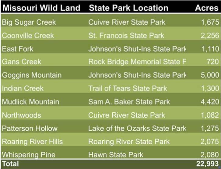
WILDERNESS FOR MISSOURI
 WILDERNESS FOR MISSOURI Completing a Conservation Legacy Summary and Fact Sheets Presented to The Office of Senator Christopher Kit Bond c/o John Stoody Prepared by: The Missouri Wilderness Coalition July
Where the Money Is In the Greater
 Where the Money Is In the Greater Guthrie Dallas Polk Des Moines Madison Warren Economy Presented by William H. Fruth POLICOM Corporation 2740 SW Martin Downs Blvd. #279 Palm City, FL 34990 772-781-5559
This section of the Plan provides a general overview of the Smoky Mountain Region. It consists of the following four subsections:
 SECTION 3 COMMUNITY PROFILE This section of the Plan provides a general overview of the Smoky Mountain Region. It consists of the following four subsections: 3.1 Geography and the Environment 3.2 Population
Bulletin August 2013 COUNTY, MUNICIPAL & TOWNSHIP PERMISSIVE MOTOR VEHICLE LICENSE TAX REVENUE RECEIVED BY TYPE OF JURISDICTION IN 2012
 (3) (4) (5) ADAMS - - - - 43,874 53,413 97,287 ALLEN 544,173 - - 544,251 301,869-846,120 ASHLAND 301,358 - - 301,401 95,991 38,463 435,855 ASHTABULA 319,512 326,226 430,584 1,076,490 453,686 357,595 1,887,771
CHAPTER 3 PARK AND RIDE DEMAND ANALYSIS
 CHAPTER 3 PARK AND RIDE DEMAND ANALYSIS The TCI analysis was supplemented by a travel demand analysis that identified the relative magnitude of park-and-ride opportunities in the three-county Capital Area
RECREATION. Seven issues were identified that pertain to the effects of travel management on outdoor recreation within portions of the project area.
 RECREATION Seven issues were identified that pertain to the effects of travel management on outdoor recreation within portions of the project area. OPPORTUNITIES FOR SOLITUDE / QUIET TRAILS. One attraction
Massanutten Mountain Cluster
 Massanutten Mountain Cluster Signal Knob Catback Mountain Southern Massanutten Mountain Five areas of almost 49,000 acres on the Lee Ranger District compose the Massanutten Mountain Cluster of Mountain
Chapter 2: Summary of Existing Open Space System
 Chapter 2: Summary of Existing Open Space System In 1976, the Wake County Board of Commissioners established the Wake County Parks and Recreation Department in order to provide park facilities and programs
MASTER PLAN EXECUTIVE SUMMARY
 Biscuit Run State Park Scottsville Road (State Route 20) Charlottesville, VA 22902 Biscuit Run State Park MASTER PLAN EXECUTIVE SUMMARY Department of Conservation and Recreation Division of Planning and
METROPOLITAN STATISTICAL AREA
 Miami-Fort Lauderdale-West Palm Beach METROPOLITAN STATISTICAL AREA Broward County is part of the 8th largest metropolitan statistical area (MSA)() in the country with a population just over 6M in 2016.
IMPORTED FIRE ANT AREAS IN TENNESSEE QUARANTINED AREAS FOR YEAR 2007
 IMPORTED FIRE ANT AREAS IN TENNESSEE QUARANTINED AREAS FOR YEAR 2007 NOTE: Italics indicate a new county or a change from year 2006. 1. Anderson County That portion of the county lying southeast of a line
Clearwater Lake Provincial Park. Draft Management Plan
 Clearwater Lake Provincial Park Draft Management Plan Clearwater Lake Provincial Park Draft Management Plan Table of Contents 1. Introduction... 3 2. Park History... 4 3. Park Attributes... 4 3.1 Location/Access...4
Eagle Rock Loop Ouachita National Forest Page 1 of 8
 EAGLE ROCK LOOP Eagle Rock Loop Ouachita National Forest Page 1 of 8 Hiking: Biking: Equestrian: Trail Highlights: This trail offers the longest loop trail in Arkansas. A combination of the Little Missouri,
1 DEMAND RESPONSE OVERVIEW
 1 DEMAND RESPONSE OVERVIEW Forty-nine transit agencies in Ohio operate demand response service, not including demand response services operated as part of the transit service provided in conjunction with
SITE HOTEL PROPERTY. For Sale. I-70 & 7 Highway (NEC) 3.99+/- Acres Total NW 7 Highway, Blue Springs, Missouri A GREATER KANSAS CITY SUBURB
 3.99+/- Acres Total NW 7 Highway, Blue Springs, Missouri A GREATER KANSAS CITY SUBURB") 63,000 cars per day HOTEL PROPERTY 1110 NW 7 Highway, Blue Springs, Missouri A GREATER KANSAS CITY SUBURB N For Sale I-70 & 7 Highway (NEC) 3.99+/- Acres Total 29,000 cars per day SITE Estimated Population
63,000 cars per day HOTEL PROPERTY 1110 NW 7 Highway, Blue Springs, Missouri A GREATER KANSAS CITY SUBURB N For Sale I-70 & 7 Highway (NEC) 3.99+/- Acres Total 29,000 cars per day SITE Estimated Population
O.C.G.A GEORGIA CODE Copyright 2014 by The State of Georgia All rights reserved. *** Current Through the 2014 Regular Session ***
 O.C.G.A. 15-6-3 GEORGIA CODE Copyright 2014 by The State of Georgia All rights reserved. *** Current Through the 2014 Regular Session *** TITLE 15. COURTS CHAPTER 6. SUPERIOR COURTS ARTICLE 1. GENERAL
THE PLAZA AT SHOAL CREEK 175,000 Sq Ft Retail Development
 THE PLAZA AT 175,000 Sq Ft Retail Development Rare 2,415 Sq Ft Retail End Cap Space - FOR LEASE Available Soon 152 Highway & Flintlock Road (SWC), Kansas City/Liberty, Missouri Natural Bowl N XO Nails
POPULATION INTRODUCTION
 POPULATION INTRODUCTION The socio-economic data available at the time of this writing is a conglomeration of data provided by the Kentucky State Data Center, OKI Regional Council of Governments, 2010 U.S.
MAPPING UNSHELTERED HOMELESSNESS IN INDIANAPOLIS ISSUE C17-20 NOVEMBER 2017
 MAPPING UNSHELTERED HOMELESSNESS IN INDIANAPOLIS ISSUE C17-20 NOVEMBER 2017 AUTHOR Chris Holcomb, Graduate Student, School of Public and Environmental Affairs, IUPUI 334 N. Senate Avenue, Suite 300 Indianapolis,
Know your market and build your business. How understanding target markets and local demographic/economic information can help local business
 Know your market and build your business How understanding target markets and local demographic/economic information can help local business March 24, 2015 About informed decisions.id stands for informed
Townships Eligible to Apply for Township Sign Grant 2018
 Townships Eligible to Apply for Township Sign Grant 2018 For more information on the Ohio Dept. of Transportation s Township Sign Grant Program, please visit the program s website at: http://www.dot.state.oh.us/divisions/planning/localprograms/pages/township_safety_s
1987 SUMMER USE SURVEY OF MINNESOTA STATE PARK VISITORS
 This document is made available electronically by the Minnesota Legislative Reference Library as part of an ongoing digital archiving project. http://www.leg.state.mn.us/lrl/lrl.asp (Funding for document
proof Northwest District
 1 Northwest District The Northwest Florida Water Management District is the most rural of all five water management districts. From just east of Tallahassee west to the Florida/Alabama line, and from the
Wright City Business Park
 Wright City Business Park 51.69 Acres SITE Wright City Business Park is a 51.69 acre site ideal for large distribution or manufacturing uses. Located approximately ¼ mile west of I-70 exit 199, Wright
The Economic Impact of Tourism in Missouri. Fiscal Year 2016 Summary December 2016
 The Economic Impact of Tourism in Missouri Fiscal Year 2016 Summary December 2016 Introduction and definitions This study measures the economic impact of tourism in Missouri in FY2016. Visitors included
The TransAm Eastern Express - Westbound Map Set #23 Watkins Mill State Park, MO to Atchison, KS 66.0 Miles / Cumulative Climbing: 2,955
 The TransAm Eastern Express - Westbound Map Set #23 Watkins Mill State Park, MO to Atchison, KS 66.0 Miles / Cumulative Climbing: 2,955 PART #1 WATKINS MILL STATE PARK TO PARADISE, MO PARADISE CYCLING
Census Affects Children in Poverty by Professors Donald Hernandez and Nancy Denton State University of New York, Albany
 Phone: (301) 457-9900 4700 Silver Hill Road, Suite 1250-3, Suitland, MD 20746 Fax: (301) 457-9901 Census Affects in Poverty by Professors Donald Hernandez and Nancy Denton State University of New York,
CHAPTER 1. INTRODUCTION. Vision Statement
 CHAPTER 1. INTRODUCTION Vision Statement The designated Iowa portion of the Mississippi River Trail (MRT) will consist of a world-class, continuous multi-use, non-motorized, on-road and off-road route
A GIS Analysis of Probable High Recreation Use Areas in Three Sisters Wilderness Deschutes and Willamette National Forests
 Lindsey Kiesz Geo 565 Term Project 3/15/2010 A GIS Analysis of Probable High Recreation Use Areas in Three Sisters Wilderness Deschutes and Willamette National Forests Introduction The Three Sisters Wilderness
APPENDIX 8. Leeds Socio-Economic Baseline Report. Report. July Metro and Leeds City Council
 APPENDIX 8 Leeds Socio-Economic Baseline Report Report July 2009 Prepared for: Prepared by: Metro and Leeds City Council Steer Davies Gleave West Riding House 67 Albion Street Leeds LS1 5AA +44 (0)113
Chapter 2: El Dorado County Characteristics and Demographics
 Chapter 2: El Dorado County Characteristics and Demographics 2.1 Geographic Area and Demographics El Dorado County comprises 1,805 square miles with over half of the area in the Eldorado National Forest
IOWA ORNITHOLOGISTS' UNION - Birding Sites in Linn County
 IOWA ORNITHOLOGISTS' UNION - Birding Sites in Linn County Printed on 6/15/2018 Bever Park (ebird Hotspot) GPS Coordinates: 41.9851219,-91.6269125 Restrooms Parking Trails ADA Accessible Trails Boyson Trail
Bulletin October 15, COUNTY VOTED 2013 PROPERTY TAX LEVIES BY PROGRAM CATEGORY, COUNTY AND RATE (For collection in 2014)
") Bulletin 2014-03 October 15, 2014 COUNTY VOTED 2013 PROPERTY TAX LEVIES BY PROGRAM CATEGORY, COUNTY AND RATE (For collection in 2014) 9-1-1 Belmont 1.0 Coshocton.2 Defiance 1.0 Delaware.45 Fulton.7 Hardin.75
Bulletin 2014-03 October 15, 2014 COUNTY VOTED 2013 PROPERTY TAX LEVIES BY PROGRAM CATEGORY, COUNTY AND RATE (For collection in 2014) 9-1-1 Belmont 1.0 Coshocton.2 Defiance 1.0 Delaware.45 Fulton.7 Hardin.75
Milwaukee River (Washington County) Segment. Kewaskum. Æÿ B. Æÿ D Southern. Kewaskum. Segment.
 Segment. Kewaskum. Æÿ B. Æÿ D Southern. Kewaskum. Segment.") Ice Age Trail Washington County Washington County FOND DU LAC WASHINGTON Æ% 28 Æÿ H Milwaukee River (Washington County) Æÿ B Æÿ S State Forest Northern Kettle Moraine Æÿ H Æ% 28 Ice Age Trail Alliance
Ice Age Trail Washington County Washington County FOND DU LAC WASHINGTON Æ% 28 Æÿ H Milwaukee River (Washington County) Æÿ B Æÿ S State Forest Northern Kettle Moraine Æÿ H Æ% 28 Ice Age Trail Alliance
Economic Impact of Kalamazoo-Battle Creek International Airport
 Reports Upjohn Research home page 2008 Economic Impact of Kalamazoo-Battle Creek International Airport George A. Erickcek W.E. Upjohn Institute, erickcek@upjohn.org Brad R. Watts W.E. Upjohn Institute
Non-motorized Trail Plan & Proposal. August 8, 2014
 Town of Star Valley Ranch, Wyoming and the Star Valley Ranch Association in partnership with the USDA Forest Service, Bridger-Teton National Forest, Greys River Ranger District Non-motorized Trail Plan
SITE FOR SALE. Race Track Development Land. Bank Owned 78 +/- Acres on Parallel Parkway 123rd Street & Parallel Parkway (SWC), Kansas City, Kansas
, Kansas City, Kansas") FOR SALE Race Track Development Land Bank Owned 78 +/- Acres on Parallel Parkway 123rd Street & Parallel Parkway (SWC), Kansas City, Kansas Supercenter SITE Parallel Parkway 40,000 cars per day PLAZA AT
FOR SALE Race Track Development Land Bank Owned 78 +/- Acres on Parallel Parkway 123rd Street & Parallel Parkway (SWC), Kansas City, Kansas Supercenter SITE Parallel Parkway 40,000 cars per day PLAZA AT
Environmental Development of River Road Ranch
 Environmental Development of River Road Ranch New Braunfels, Texas Alix Scarborough GEO 3426 April 2012 Introduction The 2,400-acre Word-Borcher ranch has been owned by the Word family since 1941. Located
Photographing Upper Peninsula Waterfalls
 Photographing Upper Peninsula Waterfalls Tod Poirier Freelance Photographer Photography is one of my passions. The following spread showcases several Upper Peninsula waterfalls. At times a single drop
Minnesota River Valley Area Survey Summary Report
 Minnesota River Valley Area Survey Summary Report Report prepared by: Minnesota Department of Natural Resources Office of Management and Budget Services May 2002 ACKNOWLEDGMENTS A number of organizations
Greater Minnesota Regional Parks and Trails Commission Designation Application
 Greater Minnesota Regional Parks and Trails Commission Designation Application General Section Designation Application #: 14-015D Date Submitted: 08/31/2015 Park or Trail Name: Alexander Ramsey Park District
Predictive Economic Impact Study for the Mount Dora to Seminole Wekiva Trail
 Predictive Economic Impact Study for the Mount Dora to Seminole Wekiva Trail Prepared By: Valerie Seidel vseidel@balmoralgroup.us 341 N. Maitland Ave., Suite 100 Maitland, FL 32751 Phone (407) 629-2185
PAD SITE FOR SALE. Hard Corner of 159th Street & Metcalf Avenue. One Acre Pad Site Available NEC 159th Street & Metcalf Avenue, Overland Park, Kansas
 PAD FOR SALE Hard Corner of 159th Street & Metcalf Avenue One Acre Pad Site Available NEC 159th Street & Metcalf Avenue, Overland Park, Kansas 3 3, 0 0 0 c a r s p e r d a y Nall Avenue 6,000 cars per
Silver Lake Park An Environmental Jewel for the Citizens of Prince William County
 Silver Lake Park An Environmental Jewel for the Citizens of Prince William County The Prince William Park Authority Mission Statement states: The Prince William County Park Authority will create quality
Testing Phone Lines:
 3/17/2019 CENTRAL IOWA FAMILY SERVICES Sunday DRUG AND ALCOHOL TESTING Testing Phone Lines: MAIN LINE FOR ALL COUNTIES EXCEPT BELOW 866-927-8161 Black Hawk Polk Linn Dubuque (319) 404-9731 Story (515)
INTRODUCTION 250,000
 INTRODUCTION The United States of America has over 250,000 rivers, with a total of about 3,500,000 miles of rivers. The main stems of 38 rivers in the United States are at least 500 miles (800 km) long.
Timesheets Clients. Fayette County GA. Carroll County AR. Gwinnett County GA. Pulaski County AR. Cook County IL. Brevard County FL.
 AR Carroll County AR Eureka Springs City 2013 Fayette County GA Peachtree City 2016 Pulaski County AR Jacksonville City 2012 Gwinnett County GA Suwanee City 2013 FL Brevard County FL West Melbourne City
Other Agencies and Organizations
 Daniel Boone National Forest 1700 Bypass Road WInchester, KY 40391 859-745-3100 Location Northern terminus is near Morehead, Kentucky. Southern terminus is located in the Big South Fork NRRA in Tennessee.
(Short Listing) DUPUYER ACREAGE, ROCKY MOUNTAN FRONT
 DUPUYER ACREAGE, ROCKY MOUNTAN FRONT") (Short Listing) DUPUYER ACREAGE, ROCKY MOUNTAN FRONT This unique property is located 8½ miles northwest of Dupuyer, Montana and approximately thirty 30 miles northwest of Choteau, Montana. Great Falls
(Short Listing) DUPUYER ACREAGE, ROCKY MOUNTAN FRONT This unique property is located 8½ miles northwest of Dupuyer, Montana and approximately thirty 30 miles northwest of Choteau, Montana. Great Falls
The gorges of Mohican Park in Ohio create a hiker's paradise Sunday, May 22, 2011 By Bob Downing, Akron Beacon Journal
 Pittsburgh Post-Gazette The gorges of Mohican Park in Ohio create a hiker's paradise Sunday, May 22, 2011 By Bob Downing, Akron Beacon Journal Bob Downing Big Lyons Falls drops 80 feet into a shady U-shaped
TENNESSEE MOUNTAIN LIVING
 NOVEMBER 2016 Featuring Jasper Highlands TNLand.com END of the YEAR December 26th to Land Sale December 31st See back cover for more info... TENNESSEE MOUNTAIN LIVING JASPER HIGHLANDS - TENNESSEE'S MOST
Wyoming Travel Impacts
 Wyoming Travel Impacts 2000-2013 Wyoming Office of Tourism April 2014 Prepared for the Wyoming Office of Tourism Cheyenne, Wyoming The Economic Impact of Travel on Wyoming 2000-2013 Detailed State and
1999 Missouri State Parks Visitor Surveys
 Missouri Department of Natural Resources Division of State Parks 800-334-6946 1999 Missouri State Parks Visitor Surveys Project Completion Report Submitted to Missouri Department of Natural Resources Division
Oregon s State Transient Lodging Tax
 Oregon s State Transient Lodging Tax Program Description, Revenue, and Characteristics of Taxpayers Calendar Years 2004-2013 150-604-005 (Rev. 4-14) Cover Photo Credits: Multnomah Falls lavenderviolettes,
Visit South Walton Visitor Tracking Study: Summer Phillip Downs, Ph.D. Joseph St. Germain, Ph.D. Rachael Anglin Downs & St.
 Visit South Walton Visitor Tracking Study: Summer 2016 Phillip Downs, Ph.D. Joseph St. Germain, Ph.D. Rachael Anglin Downs & St. Germain Research Study Objectives Profile travel parties to South Walton
APPENDIX OFFICIAL MAP ORDINANCE OF HAMILTONBAN TOWNSHIP OFFICIAL MAP NARRATIVE
 APPENDIX A OFFICIAL MAP ORDINANCE OF HAMILTONBAN TOWNSHIP OFFICIAL MAP NARRATIVE INTRODUCTION: The Official Map of Hamiltonban Township has been prepared to identify those lands and features that Hamiltonban
2010 El Paso Work Place Travel Survey Technical Summary
 2010 El Paso Work Place Travel Survey Technical Summary Prepared by the Texas A&M Transportation Institute June 2013 2010 El Paso Work Place Travel Survey TECHNICAL SUMMARY Texas Department of Transportation
SYNOPSIS OF INFORMATION FROM CENSUS BLOCKS AND COMMUNITY QUESTIONNAIRE FOR TONOPAH, NEVADA
 TECHNICAL REPORT UCED 93-04 SYNOPSIS OF INFORMATION FROM CENSUS BLOCKS AND COMMUNITY QUESTIONNAIRE FOR TONOPAH, NEVADA UNIVERSITY OF NEVADA, RENO i Synopsis of Information from Census Blocks and Community
Baku, Azerbaijan November th, 2011
 Baku, Azerbaijan November 22-25 th, 2011 Overview of the presentation: Structure of the IRTS 2008 Main concepts IRTS 2008: brief presentation of contents of chapters 1-9 Summarizing 2 1 Chapter 1 and Chapter
Cooling Centers (Full Listing)
") Cooling Centers (Full Listing) Office Address City Zip Calumet Park Englewood Garfield Humboldt Park Lower North Northwest 831 West 119 th 5323 South Western 500 North Pulaski 2753 West North 2650 West
Cooling Centers (Full Listing) Office Address City Zip Calumet Park Englewood Garfield Humboldt Park Lower North Northwest 831 West 119 th 5323 South Western 500 North Pulaski 2753 West North 2650 West
Indiana Office of Tourism Development. Product Development Research
 Indiana Office of Tourism Development Product Development Research October 2006 TABLE OF CONTENTS TABLE OF CONTENTS...1 BACKGROUND & OBJECTIVES... 2 METHODOLOGY... 3 TRIP MOTIVATORS & TYPES... 4 TRAVEL
Metropolitan Statistical Area (MSA) Exports to the World
 Exports to the World") Florida s 2015 Metropolitan Statistical Area (MSA) Exports to the World PREPARED BY: Enterprise Florida, Inc. International Trade & Development 201 Alhambra Circle, Suite 610 T: (305) 808-3660 Coral Gables,
Florida s 2015 Metropolitan Statistical Area (MSA) Exports to the World PREPARED BY: Enterprise Florida, Inc. International Trade & Development 201 Alhambra Circle, Suite 610 T: (305) 808-3660 Coral Gables,
Visual and Sensory Aspect
 Updated All Wales LANDMAP Statistics 2017 Visual and Sensory Aspect Final Report for Natural Resources Wales February 2018 Tel: 029 2043 7841 Email: sw@whiteconsultants.co.uk Web: www.whiteconsultants.co.uk
DOWNLOAD PDF MISSOURI HIKING TRAILS
 Chapter 1 : Ozark Trail Missouri Hiking Trails Midwest Hiking Trails Offering more than 6, acres of camping, fishing and trails, Cuivre River State Park is perfect for hikers looking to devote a few days
Wyoming Travel Impacts
 Wyoming Travel Impacts 2000-2014 Wyoming Office of Tourism April 2015 Prepared for the Wyoming Office of Tourism Cheyenne, Wyoming The Economic Impact of Travel on Wyoming 2000-2014 Detailed State and