TOWNSHIP OF WILMOT TRAILS MASTER PLAN Appendix B: Implementation Plan
|
|
|
- Baldric Lawrence
- 5 years ago
- Views:
Transcription


1 TOWNSHIP OF WILMOT TRAILS MASTER PLAN Appendix B: Implementation Plan Final Report January 2015 Prepared for: Prepared by:
2 EXECUTIVE SUMMARY IMPLEMENTATION PLAN The Wilmot Trails Master Plan (WTMP) is more than a proposed network of trails. It is a Plan that promotes safe trails use and recognizes the benefits of health and quality of life trails can offer. The development of the WTMP Implementation Plan was overseen by the Township of Wilmot and provides a framework for creating a connected trail system throughout the Township. This primarily non motorized system is envisioned to serve a diverse range of users, providing safe and well maintained linkages to important natural, cultural and civic destinations, and other points of interest within and outside the Township. The implementation recommendations in the WTMP over the next 10+ years will see the Township of Wilmot begin to keep pace with growing public demand for a high quality, connected trail system that connects neighbourhoods with recreation, shopping and employment areas. The Implementation Plan builds upon past and current trail development efforts. The Plan is intended as a blueprint to guide the development, operation, and maintenance of trails throughout the Township of Wilmot in the short, medium, and long term. The WTMP Implementation Plan focuses on several key objectives including: 1. Implementing a continuous and connected trail system throughout the Township of Wilmot; 2. Identifying four (4) different types of trails proposed with the network hierarchy; 3. Enhancing and improving the continuity and connections to existing developed trails including connections to adjacent municipalities; 4. Ensuring trails implementation and trails infrastructure within all new neighbourhoods; 5. Overall responsibility of Trails Master Plan implementation will be coordinated through the Facilities and Recreation Department; 6. Establishing a Trails Interdepartmental Working Group; 7. Focusing on trail promotion and funding throughout the Township; 8. Strengthening current design standards and maintenance practices and making recommendations for changes based on best practice research; and 9. Developing trail development costs and prioritizing projects for construction. The overall responsibility of implementing the Trails Master Plan will be coordinated through the Facilities and Recreation Department. Within the Wilmot budget process, the necessary resources to transition this roll into the department shall be determined. The Facilities and Township of Wilmot Trails Master Plan Executive Summary - Page 1 of 2
3 Recreation Department guided by the Trails Interdepartmental Working Group will be responsible for championing trails initiatives and programming throughout the Township. They should coordinate all activities related to Wilmot Trails including trail planning, development, approvals, volunteers, trail maintenance, grant applications (if applicable) and monitoring, budget preparation, assistance with special events, public relations, and media liaison. The success of the WTMP is dependent on initial and on going support of the Township of Wilmot Council and the Facilities and Recreation Department guided by the Trails Interdepartmental Working Group. An integrated trail system yields many benefits such as recreational opportunities, health benefits, increased community stewardship, and influence on the overall transportation infrastructure. A successful trail network offers landscape variety, a range of physical challenges, good wayfinding techniques, accessible options, connectivity, and supporting facilities and services. Trails must be recognized not only as important recreational resources within the Township, but also as critical components of the active transportation infrastructure. Township of Wilmot Trails Master Plan Executive Summary - Page 2 of 2
4 APPENDIX B IMPLEMENTATION PLAN PART 1 TRAIL DESIGN GUIDELINES AND CONSTRUCTION STANDARDS 1.0 Guidelines to Trail Development in the Township of Wilmot 1.1 How to Use the Trail Guidelines 1.2 Trail Users and Needs Pedestrians Cyclists In Line Skaters, Skateboarders, and Non motorized Scooter Users Wheelchairs and Motorized Wheelchairs/Scooters All Terrain Vehicles, Dirt Bikes, and Snowmobiles 1.3 General Trail Design Parameters 1.4 Accessibility and AODA Requirements 1.5 Personal Security and CPTED 1.6 Trail Lighting 1.7 Trail Hierarchy and Surfacing Boulevard Multi use Trails On road Trail Connections Shared Use Lanes and Paved Shoulders Bike Lanes 1.8 Trail Crossings Minor and Major Roads Active Railways Bridges Underpasses and Tunnels 1.9 Off Road Trail Structures Gates and Barriers Swing Gates Bollards Elevated Trailbeds and Boardwalks Switchbacks and Stairs Township of Wilmot Trails Master Plan Page 1 of 47
5 1.10 Trail Signage Signage Strategy and Typical Branding Signage Types a) Gateway Signage b) Orientation and Trailhead Signage c) Trail Etiquette Signage d) Regulatory/Caution Signage e) Interpretive Signage f) Route Markers and Trail Directional Signage 1.11 Trailheads and Trail Amenities Seating and Rest Areas Bicycle Parking Trail Closures and Rehabilitation 1.12 Trails in Natural Areas and Environmental Buffers 1.13 Creating New Trails in Established Neighbourhoods 1.14 Public Outreach and Trail Promotion Community Based Social Marketing Wilmot Trail Map, Signs, and Brochures Trail Ambassadors Partnerships PART 2 THE IMPLEMENTATION PLAN 2.0 The Implementation Plan 2.1 Priorities and Network Phasing 2.2 Trail Implementation Trails Interdepartmental Working Group Comprehensive Implementation Operating Costs 2.3 Potential Funding Sources 2.4. Managing Implementation Plan and Expectations Insurance, Liability, and Risk Management Establishing a Trail Maintenance Plan Township of Wilmot Trails Master Plan Page 2 of 47
6 2.4.3 Location and Trail Alignment Maintenance Considerations Trail Surfacing Materials Maintenance Considerations Winter Maintenance of Trails 2.5 Summary of Recommendations LIST OF TYPICAL TRAIL DETAILS Figure 1 Typical Asphalt Trail Detail Figure 2 Typical Stonedust Trail Detail Figure 3 Typical Natural Ground Trail Detail Figure 4 Elevated Trailbed for Asphalt and Stonedust Trails Figure 5 Urban Road (Boulevard Trail) Cross Section Figure 6 Rural Road Cross Section Figure 7 Typical Mid Block Crossing (Minor Road) Figure 8 Typical Mid Block Crossing (Major Road) Figure 9 Typical Trail Crossing of Major Road near Intersection Figure 10 Typical Railway Crossing Detail Figure 11 Typical Major Trailhead/Staging Area Figure 12 Typical Minor Trailhead/Staging Area Figure 13 Typical Trail Junction Figure 14 Trail Swing Gate/Access Barrier Figure 15 Trail Switchback Figure 16 Culvert Crossing Figure 17 Typical Boardwalk Cross Section and Elevation Figure 18 Permanent Trail Closure/Rehabilitation Barrier Figure 19 Trail Signage Details Figure 20 Unit Cost Schedule Figure 21 Accessibility Standards for the Built Environment relating to Recreational Trails Figure 22 Highway Traffic Act Excerpts Township of Wilmot Trails Master Plan Page 3 of 47
7 PART 1 TRAIL DESIGN GUIDELINES AND CONSTRUCTION STANDARDS 1.0 Guidelines to Trail Development in the Township of Wilmot An integrated trail system yields many benefits such as recreational opportunities, health benefits, increased community stewardship, and influence on the overall transportation infrastructure. A successful trail network offers a landscape variety, a range of physical challenges, good wayfinding techniques, accessible options, connectivity, and has supporting facilities and services. Trails must be recognized not only as important recreational resources within the Township, but also as critical components of the active transportation infrastructure. Trail design and maintenance will significantly influence users decisions to return and utilize the trail network within the Township. Trails that have been thoughtfully designed and constructed will typically show better performance over their lifespans, lessen impacts to the surrounding environments, and have fewer liability concerns. Better quality trail design and construction will attract more users and alleviate more long term maintenance measures. The better the quality of the trail design and construction, the more attractive it will be to users, the more it will be used, and the more long term maintenance measure will be alleviated. Trail users vary widely in terms of age and physical ability, each having their own interpretations of what the trail experience should be. The design approach where one trail type is sufficient does not apply to all trails, and it is important to try and match the trail type and design with the type of desired experience. A cohesive, slightly innovative, and high quality trail design makes all the difference and will create a strong community asset where user experience, enjoyment, and safety are maximized. 1.1 How to Use the Trail Guidelines This implementation plan has been developed to assist the Township in making educated decisions about trail design and implementation. The plan provides general information about trail users and their needs and abilities. To better assist the Township, summary tables have been included to highlight key design recommendations and considerations in addressing features associated with various trail types. The standard recommendation typically aims to achieve trail design standards that illustrate acceptable conditions based on widths, accessibility, safety, and maintenance. Trail standards may change based on site specific locations and conditions. Township of Wilmot Trails Master Plan Page 4 of 47
8 The information presented within these trail guidelines is based on currently accepted North American trail design practices and ongoing research and experience gained during initial years of trail implementation. The guidelines are not intended to be prescriptive but rather should be treated as a reference to be consulted during the individual planning, development, and construction of the trail network. They are not meant to be inclusive of all trail design standards for all locations, nor are they meant to replace sound engineering judgment. These guidelines are not intended to be detailed solutions to site specific problem areas and therefore specific design exercises involving detailed site inventory should be applied as part of the analysis for any trail development within the Township. 1.2 Trail Users and Needs Trail user characteristics and preferences are critical in the development and implementation of these guidelines. Within the Township the potential trail users can include pedestrians, cyclists, in line skaters, and users with mobility aids, scooters, and snowmobiles (in sanctioned locations). The below sections briefly describe each of these users, their typical use of trails, and the general trail design parameters that should be considered Pedestrians Pedestrians are generally divided into sub categories such as: Walkers; Hikers; Joggers and Runners. Walkers Walking is typically enjoyed by a wide range of individuals of all levels of physically activity and health. Walking is characteristically the most highly used method of travel for trails as such trail guidelines that facilitate walking must be established for all potential trail users. Walkers represent a wide range of interests and motives such as; leisure, relaxing, socializing, exploring, contacting with nature, meditation, fitness, or dog walking. Walking trails need to consider not only single individuals but also users, who may have sensory, cognitive or ambulatory difficulties, as well as: Walkers with baby strollers; Walking aids; Walking in pairs or groups (e.g. school groups, nature walks); and Walking for utilitarian or transportation purposes. Township of Wilmot Trails Master Plan Page 5 of 47
9 Individuals who use walking as a method of transportation typically tend to be more urbanfocused. In addition to using sidewalks, parking lots and urban plazas, the utilitarian walker will use trails that are convenient, well designed, and properly maintained. Hikers Hikers are considered more elite than the traditional recreational walking group and may challenge themselves to cover longer distances; they may also walk on shoulder sections of rural roadways, which are considered less safe and interesting to the majority of leisure walkers. Several characteristics of hikers relating to their use of the trail network include: Day trips that range between 5km and 20km in length; More interested in the natural environment and nature; More skilled at orienteering; Self sufficient and expect fewer trail amenities (e.g. benches, rest nodes); and Typically more attracted to challenging terrain and rural areas. Joggers and Runners Sharing more profile characteristics with distance hikers than with leisure walkers, runners and joggers primary trail use motives are fitness and exercise. Their use of on road and offroad trails is typically distance orientated (e.g. run/jog for 5km, 10km, 15km, etc.) and they tend to use trails at higher speeds than leisure walkers and hikers. As a direct benefit of the cushioning effect, runners and joggers prefer to use granular surfaced trails and/or natural ground trails Cyclists The mechanical efficiency of bicycles allows users of all ages to significantly increase their travel speed and distance, allowing them to experience trail corridors differently. Naturally road bikes perform very differently than mountain bikes, as such; the trail conditions and standards for both types of bikes differ. Mountain bikes can more easily navigate stonedust surfaces and natural ground trails, where road bikes typically require asphalt trails/pavements. Fitness levels and motivation of the individual cyclist vary as well. Although cyclists have the right to access the extensive existing public roadway system, with the exception of the Conestoga Parkway (Highway 7/8), many inexperienced cyclists feel unsafe sharing the road with automobiles. Off road trails, typically shared with pedestrians, offer recreational and commuter cyclists a more secure environment and an increased sense of safety. Township of Wilmot Trails Master Plan Page 6 of 47
10 It is recommended that speed limits and warning signs (e.g. steep grades) be posted along trails to discourage fast riding and aggressive behaviour. Cyclists other than young children should be discouraged from cycling on sidewalks and should adhere to municipal by laws In Line Skaters, Skateboarders, and Non motorized Scooter Users In line skating, skateboarding and the use of non motorized scooters are becoming increasingly popular among all age groups, particularly in urban areas. The Ministry of Transportation for Ontario (MTO) does not consider in line skaters vehicles when considering purpose of travel and speed. In some municipalities, in line skaters, skateboarders, and scooter users have been prohibited from using either roadways or sidewalks by municipal by laws. In line skaters and skateboarders naturally prefer smooth, hard surfaces, and loose sand, gravel, fallen branches, fallen leaves, cracking, and even puddles can be significant hazards. Although skateboarders and scooter users can quickly become pedestrians by dismounting, they too are vulnerable to the effect of significant grade changes and require significant maneuvering space. Restricted visibility can also be regarded as a significant hazard for this user group depending on an individuals experience level Wheelchairs and Motorized Wheelchairs/Scooters The Accessibility for Ontarians with Disabilities Act (AODA) is proposing many changes in order to improve accessibility for persons with a disability, this includes access to trails. Community members may rely on motorized and non motorized wheelchairs and scooters to carry out their daily lives. The ability of a wheelchair or scooter to negotiate a trail will depend upon the type of trail and the type of wheelchair or scooter. Within the Township where trails are to be developed to be accessible to all users, there may be a need to obtain input from these users to determine the trail type surface and width required prior to implementation All Terrain Vehicles, Dirt Bikes, and Snowmobiles All Terrain Vehicles (ATV) and dirt bikes are very popular year round utility and recreational vehicles that offer many hours of enjoyment for outdoor enthusiasts. However, there are certain risks associated with riding ATV s and dirt bikes if municipal by laws are not respected and safety precautions are ignored. ATV s and dirt bikes are prohibited from travelling along municipal roads and trails within the Township. Township of Wilmot Trails Master Plan Page 7 of 47
11 There are several snowmobile clubs within the Township of Wilmot and surrounding areas (e.g. Nith Valley Sno Surfers) and through comprehensive partnerships and regulations snowmobiles are exempt in sanctioned locations along the trail network. Existing trail corridors, including sanctioned snowmobile trails will, when possible and appropriate, be incorporated within the design of new and redeveloped areas to maintain the integrity of the trail network and provide safe snowmobile roadway crossings. Ontario Federation of Snowmobile Clubs ( The Ontario Federation of Snowmobile Clubs (OFSC) is a volunteer led not for profit association, which provides a wide range of programs and services to and on behalf of, its member organizations. The association aims to provide a Provincial network of organized snowmobile trails that connects Ontario communities and responsible riding experiences that are safe, enjoyable and environmentally suitable. Snowmobile club members with valid OFSC memberships should be the only permitted snowmobile users on the trails. This regulation will assist in developing a positive attitude toward snowmobile trails users. It is recommended that when the Township designs or implements trails adjacent to or that cross an OFSC trail that they work in conjunction with the local OFSC representatives to ensure that standards, rules, and regulations are being achieved. 1.3 General Trail Design Parameters Careful consideration should be given to the physical, aesthetic, and environmental requirements for each trail type in the network. In many instances the physical design criteria related to operating space, design speed, alignment and clear zones are often governed by the needs of the fastest, most common user group on the trail network. Trail user operating space is a measurement of the horizontal space that the user requires and often includes additional distances to the trail surface commonly known as clear zones. The below Table describes optimal operating Optimal Trail User Operating Guidelines spaces for different trail uses. Standard Width Roads are designed to Trail User Type (Metres) accommodate vehicles that One way travel (one wheelchair user) 1.5 move at a significantly higher One way travel (two pedestrians) 1.8 rate of speed than bicycles, One way travel (one cyclist) 1.2 therefore it is assumed that One way travel (one in line skater) 2.5 horizontal alignment of onroad routes will be ample to Two way travel (two cyclists) 3.0 Two way travel (two wheelchair users) 3.0 accommodate cyclists and other trail users. Two way travel (two pedestrians) 3.0 Township of Wilmot Trails Master Plan Page 8 of 47
12 Sight stopping distance is defined as the distance required for a trail user to come to a full controlled stop upon spotting an obstacle. It is a function of the user s perception and reaction time and is similar in nature to a motor vehicle on a road spotting an obstacle. Stopping sight distances for off road trails are typically governed by the distance required for cyclists since pedestrians and other trail users (with the exception of in line skaters) can typically stop more immediately than cyclists, regardless of the trail configuration. 1.4 Accessibility and AODA Requirements The Accessibility for Ontarians with Disabilities Act (ODA) states that the people of Ontario support the right of persons of all ages with disabilities to enjoy equal opportunity and to participate fully in the life of the province 1. The stated goal of the AODA is to make Ontario accessible for people with disabilities by The Accessibility Standards for the Built Environment is the standard that applies to new trail development. The intent is to help remove barriers in buildings and outdoor spaces for people with disabilities. The standard will only apply to new construction and extensive renovation. The guidelines and criteria set out in these documents apply to the development of recreational trail and sidewalk facilities, and are not mandatory for the design of on road cycling facilities. AODA criteria which are to be considered include: operational experience, width, longitudinal /running slope, cross slope, total slope, surface, changes in level and signage. When designing and implementing trail facilities, the Township should refer to the guidelines outlined in the Built Environment Standards. Referring to these standards will ensure the needs of all user groups are accommodated and will satisfy the requirements of the AODA to the greatest extent possible, given the context of each trail s location, the surrounding environment and type of trail experience that is desired. Sections 80.6, 80.8, and 80.9 of the Accessibility Standards for the Built Environment provides technical requirements for recreational trails, which includes: Minimum clear width 1.0m Minimum head room clearance of 2.1m above trail Surfaces are to be firm and stable Maximum running/longitudinal slope of 10% Maximum cross slope of 2% High tonal or textural changes to distinguish edges 1 Ontarians with Disabilities Act, 2005 Township of Wilmot Trails Master Plan Page 9 of 47
13 Standards also address changes in level, openings in the surface, edge protection (e.g near water); and Signage shall be easily understood and detectable by users of all abilities. It is important to ensure that signage and mapping / messaging clearly communicates which trails are accessible so that users can make an informed personal decision about which pathways to use. Please refer to the appended design details for a more detailed description of Sections 80.6, 80.8, and 80.9 of the Accessibility Standards for the Built Environment. Universal Trail Design is a concept that takes into consideration the abilities, needs, and interests of the widest range of possible users. In regards to trail design, it means planning and developing a range of facilities that can be experienced by a variety of users of all abilities. Principles of universal trail design can be summarized as follows: Equitable use: provide opportunity for trail users to access, share and experience the same sections of trail rather than providing separate facilities; Flexibility in use: providing different options for trail users in order to accommodate a variety of user experiences; Simple, intuitive, and perceptible information: whether conveying trail information through signage, maps or a web site, communicate using simple, straightforward forms and formats with easy to understand graphics and/or text; Tolerance for error: design trails and information systems so as to minimize exposure to hazards, and indicate to users any potential risks or challenges that may be encountered; Low physical effort: trails may provide for challenge but should not exceed the abilities of the intended users; where appropriate, rest areas should be provided; and Size and space for approach and use: trails and amenities should provide trouble free access, comfort and ease of use. Ontario s Best Trails (2006) provides an in depth discussion of the application of Universal Design principles and their application. Trails should be designed to be accessible to all levels of ability, where possible and practical. It must be recognized however, that not all trails throughout the system can be fully accessible. Steep slopes are one of the most significant barriers for those with physical disabilities. Designing trails to be within the threshold (5%) for universal access will not only overcome this significant barrier but it will help to reduce potential erosion of the trail surface. Township of Wilmot Trails Master Plan Page 10 of 47
14 The following are some additional considerations for making new and existing trails accessible: Designers should consult current standards that are available in the Township of Wilmot; Where trails require an accessibility solution that is above and beyond what is normally encountered, a representative of the Accessibility Committee should be consulted early on in the process to determine if it is practical and desirable to design the trail to be fully accessibility; Where it has been determined that full accessibility is appropriate, the accessibility representative should be consulted during the detailed design process to ensure that the design is suitable; and Work collaboratively with the Accessibility Committee to consider developing signage/content to clearly indicate trail accessibility conditions, which allows users with mobility assisted devices to make informed decisions about using a particular trail prior to travelling on it. 1.5 Personal Security and CPTED Principles of Crime Prevention Through Environmental Design (CPTED) should be considered and applied to help address security issues concerning trail use, particularly in locations where trails are infrequently used, isolated or in areas where security problems have occurred in the past. To the extent possible, trails should be designed to allow users to feel comfortable, safe, and secure. Several good design aspects that take into account The four main underlying principles CPTED principles when designing and of CPTED are: implementing trails are: natural access control; Provide the ability to find and obtain help. natural surveillance; Signs should inform users of where they territorial reinforcement; and are along the trails system and include maintenance local emergency contact information for fire, police, and ambulance services; Good visibility by other people and trail users by locating routes through well used, lit public spaces; Provide escape routes from isolated areas at regular intervals; Design adequate sight lines and sight distances for users; Provide trailhead parking in highly visible areas; Township of Wilmot Trails Master Plan Page 11 of 47
15 Minimize routing of trails close to woodlot edges, water features, dams, and places where danger typical occurs; Design underpasses and bridges so that users can see the end of the features as well as the areas beyond; and Place caution signage if dangerous and isolated areas are unavoidable and indicate those areas on overall and individual trail signage mapping. 1.6 Trail Lighting Trail lighting is often an expensive and somewhat controversial subject in trail development. Very few municipalities make the decision to light their entire trail system for a number of reasons which include: Installation costs; Scale and scope of lighting a specific route; Location of power supplies in remote areas along the trail network; Staffing time and material cost to properly monitor and maintain lamp fixtures and replace broken and burned out bulbs on a regular basis; Vandalism; Energy consumption; Dark sky and excessive light pollution, especially in residential areas and adjacent to natural areas; Potential detrimental effects on flora and fauna, especially with light pollution in natural areas such as woodlots; and Inability of the human eye to adapt to the high contrast resulting from brightly lit and dark shadowed areas adjacent to one another. Lighting the entire trail system is not recommended, however there may be some locations where lighting attractions and facilities (e.g. major parks or heavily used routes to major destinations) might extend user usage and enjoyment. Trail lighting along a route needs to be made on a site specific basis and developed in conjunction with an electrical engineer. Township of Wilmot Trails Master Plan Page 12 of 47
16 1.7 Trail Hierarchy and Surfacing There are four (4) different types of trails proposed in the Township of Wilmot network hierarchy. Trail Hierarchy and Surfacing 1. PRIMARY TRAILS Description and Connectivity Typical Location Design Characteristics Wilmot Examples Township wide functions and important transportation / commuter routes connecting communities, neighbourhoods, parks, community facilities, commercial sites, institutions and residential areas Potential for 4 season transportation corridor with opportunities for direct and continuous movement in east west and north south directions throughout the Township Provide access to major destinations throughout the Township Connect to surrounding municipalities Located outside of the road right of way in continuous linear corridors through Township Can be located within the road right of way for on road cycling routes and/or connections Minimum 3.0m width; compacted granular surface (stonedust) Accommodate two way traffic volumes Designed to meet or exceed minimum accessibility requirements Preferred 4 season maintenance for year round walking, cycling, transportation and recreational use Typically designed to highest standards relative to other trail hierarchy types to accommodate high volumes of use, destinationoriented traffic, widest range of use abilities and important links to major community facilities Year round connections between areas of housing, employment, transit, commercial services, retail, community facilities and other destinations Support pedestrian convenience and walkability and a range of active transportation opportunities Most cycling routes Baden to WRC New Hamburg to WRC 2a. SECONDARY TRAILS OFF ROAD TRAILS AND/OR SEPARATED BOULEVARD TRAILS Description and Connectivity Township wide function and available as transportation routes during the spring, summer and fall seasons Township of Wilmot Trails Master Plan Page 13 of 47
17 Provides additional connections to adjacent municipalities, neighbourhoods, parks, community facilities, natural areas, and schools Typical Location Located outside of the road right of way in continuous linear corridors (off road) In some locations, particularly developed neighbourhoods, it will be necessary to make short connections between off road segments by joining them to on road connections On urban arterial, collector or rural roads where there is ample right of way between the edge of the road (curb for urban cross section and shoulder for rural cross section) and the limit of the right of way to maintain a minimum separation between the road and the trail (boulevard multi use pathways) Design Typically 2.4m 3.0m width; compacted granular surface (stonedust) Characteristics Site specific locations may be hard surfaced (e.g. asphalt) or boardwalk to respond to site conditions Accommodate two way traffic volumes 3 season maintenance (4 season for school routes) Designed to meet minimum accessibility requirements where practical and feasible 3 season transportation function and year round recreational function Designed for moderate to high volume usage and a wide range of users Wilmot Examples Nith River Trail Alder Creek Trail 2b. SECONDARY TRAILS ON ROAD MULTI USE TRAILS WITHIN ROAD R.O.W. Description and Provides a multi use primary or secondary trail connection Connectivity throughout the Township Typical Location On urban arterial, collector or rural roads directly adjacent to or along shoulders of vehicular travel lanes Provides connections between key Township destinations Along corridors where there are limited commercial or residential driveway crossings Design Developed on site specific basis Characteristics Developed in conjunction with MTO Bikeways Planning and Design Guidelines Township of Wilmot Trails Master Plan Page 14 of 47
18 Developed in conjunction with TAC Bikeway Traffic Control Guidelines (Second Edition, 2012) and Ontario Traffic Manual Book 18 Cycling Facilities 2c). SECONDARY TRAILS SHARED WINTER USE TRAILS BETWEEN MOTORIZED AND NON MOTORIZED TRANSPORTATION Description and Developed on site specific basis and includes off road, asphalt or Connectivity stonedust trails that facilitate walking, road and hybrid biking, snowshoeing, cross country skiing, and snowmobile uses. ATV use is prohibited Typical Location Located outside of the road right of way in continuous linear corridors (off road) On urban arterial, collector or rural roads where there is ample right of way between the edge of the road (curb for urban cross section and shoulder for rural cross section) and the limit of the right of way to maintain a minimum separation between the road and the trail (boulevard multi use pathways) Design Typically 3.0m+ in width; compacted granular surface (stonedust) to Characteristics accommodate two way travel Developed in conjunction with Ontario Federation of Snowmobile Clubs (OFSC) Signage to be coordinated with local clubs (e.g. cross country skiing, Nith Valley Sno Surfers) Cross country skiers favour loop trails over linear trails with connector trails and cutoffs to allow different lengths and permit easy return access Maintains clear zones Uses proper signage (speed limits, OFSC signage, directional, etc.) 3a. TERTIARY TRAILS PARK TRAILS Description and Local routes within Township owned parklands between points of Connectivity interest and facilities within neighbourhood parks Can also function as main routes to features such as playgrounds and washrooms in local parks Maintenance access routes within parks In some cases may include school routes, isolated loops or solitary pathway segments Typical Location Within Township owned parklands May or may not be connected to primary and secondary trails Township of Wilmot Trails Master Plan Page 15 of 47
19 May be isolated loop or link within parklands Design Typically 1.5m 3.0m width depending on location Characteristics Trail surface is typically compacted granular, but hard surface will be used where part of the design of the park or an accessible route to park amenities is featured Generally maintained for 3 season use; winter maintenance should be considered for school routes Meets minimum accessibility requirements whenever possible. Uses may be limited by the nature of the trail location, trail alignment, width and surface type. May include lighting as dictated by the park design Wilmot Examples Constitution Park (New Hamburg) Schneller Drive to Elizabeth Street (Baden) Brewery Street to Foundry Street (Baden) Baden Pond Loop 3b. TERTIARY TRAILS STORM WATER MANAGEMENT TRAILS Description and Designed to incorporate combined maintenance access and Connectivity recreational trails that loop around storm water management areas to provide for both maintenance and recreational uses Perimeter trails will also establish public uses of the facility and minimize encroachments of private land owners onto public property Typical Location Within storm water management facilities Small connections to storm water management facilities Design Asphalt where maintenance access and trail use are shared; Characteristics compacted granular (stonedust) for remainder Portions of the trail may be wider than the primary trail standard to accommodate maintenance and service vehicles Consider width and turning radii of service access vehicles when designing trails around SWM areas Wilmot Examples Adjacent to Livingston Boulevard (Baden) Samuel Foster Court (Baden) Smith s Creek Drive (New Hamburg) 4. NATURAL GROUND TRAILS Description and Trails designed for recreational purposes that may include the use of Connectivity private and public lands Created by the Township or volunteer groups that have established Township of Wilmot Trails Master Plan Page 16 of 47
20 Typical Location Design Characteristics Wilmot Examples arrangements with the Township where the trails are on public land, or with land owners where trails are located on private lands Established woodlots Natural areas Typically not connected to primary or secondary trails Width will vary, but typically m depending on locations Natural earth surface; some locations may require a granular surfaces or boardwalks Accommodates one way travel Provides limited access, with no special accommodations made for specific user groups (e.g. bicycles, strollers, mobility assisted devices) Minimal maintenance (dictated by municipal by laws, natural area management plans, etc.) Typically does not meet minimum accessibility requirements Walker Woods Laschinger Woods Townline Regional Forest Gibney Regional Forest Minimum trail corridor widths will vary based on trail locations and whether trails are located in constrained linear or wildlife corridors. Where trails are to be located within designated wildlife corridors or adjacent to sensitive woodlots, a minimum 6.0m corridor width will be provided, which includes the trail and trail clear zone as well as a suitable buffer from the wildlife passage area in the corridor; Trails links between residential or commercial lots that connect to the trail system should be designed with a minimum 6.0m corridor width and a minimum 3.0m trail in the centre of the corridor; and Walkway connecting links that consist of a 1.5m concrete sidewalk are to be located in a minimum 6.0m corridor. There are several options for trail surface materials, each with its own set of advantages and disadvantages, relating cost, availability, efficiency of installation, maintenance requirements, and compatibility with various trail users groups. The below table summarizes the most commonly used trail surfacing materials along with some advantages and disadvantages. There is no one trail surface material that is appropriate in all locations, and material selection Township of Wilmot Trails Master Plan Page 17 of 47
21 during the design stage must be considered on a site specific basis, location, and anticipated user group. Within surrounding municipalities, asphalt is the most commonly used hard surface trail material with stonedust the most extensively accepted granular surface. Trail Surfacing Advantages and Disadvantages Trail Type Advantages Disadvantages Asphalt Stonedust (and other granulars) Smooth, consistent surface Adapts well to surrounding grades Easily negotiated by a wide range of trail user groups Relatively easy to install by skilled trades Pit Run: Mixed granular material containing a wide range of particle sizes from sand to cobbles Excellent for creating a strong sub base Relatively inexpensive Moderate high installations costs Must be installed by skilled trade/asphalt paving company Typical lifespan of years depending on the quality of the initial installation Poor base preparation can often lead to long term maintenance problems Cracking occurs near the edges, grass and weeds can invade cracks and speed up deterioration Not recommended or appropriate for trail surfacing. B Gravel: Similar characteristics to Pit Run Regulated particle sizes Excellent for creating strong, stable and well drained sub bases and bases Relatively inexpensive Not recommended or appropriate for trail surfacing Granular A : Similar characteristics to Granular B Potential risk for erosion on Township of Wilmot Trails Master Plan Page 18 of 47
22 Smaller maximum particle sizes Excellent for trail bases, may be appropriate for trail surfacing in rural areas and woodlots. Easy to spread and re grade when surface deformities develop Clear stone and/or Pea Gravel: Crushed and washed granular Particles of uniform sizes, no sand or fine particles included Excellent bedding course for trail drainage structures Can make excellent base for asphalt trails slopes Some users have difficulty negotiating the surface due to ranges in particle sizes and uneven sorting of particles that can take place over time with surface drainage Not recommended or appropriate for trail surfacing Wood Chips and Wood Shavings Earth Surface (Natural Stonedust: Mixture of fine particles and small diameter crushed stones Levels and compacts very well and creates a smooth surface that accommodates a wide variety of trail users Easy to spread and re grade when surface deformities develop Inexpensive Bark or wood chips Particle sizes range from fine to coarse depending on product Soft feel and very natural appearance Aesthetically appropriate for woodlot and natural area settings Can be difficult to negotiate Very low cost East to install Desirable and cost effective trail for use on tertiary trails Most typically used and accepted as the surface of choice for most granular surfaced trails Can deteriorate over time Source of material must be carefully researched to avoid unintentional importation of invasive species (plants and insects) Potential risk for erosion on slopes Township of Wilmot Trails Master Plan Page 19 of 47
23 Ground) Wood (e.g. bridges, boardwalks) Blends visually with the surroundings Generally does not require additional material Very inexpensive Highly attractive Renewable material that creates a solid and level travel surface Can allow for continual trail access over debris, steep areas, and wet/seepage areas Some users have difficulty negotiating surface due to range in particle sizes and uneven sorting of particles that can take place over time with surface drainage Existing soil conditions can pose problems (e.g. poorly drained and permanently wet soils generally do not make for good trail surfaces) Minor clearing of brush and debris may be necessary to adhere to clear zones Often requires skill to install Permits and approvals Expensive installation Boulevard Multi use Trails Additional applicable polices and plans include: Transit Supportive Guidelines, 2013 Ontario Cycling Strategy, 2012 Bill 51 Plan Reform, 2006 Provincial Policy Statement, 2005 Accessibility for Ontarians with Disabilities Act, 2005 The Ontario Trails Strategy, 2005 Municipal Act, 2001 Bicycles are recognized as a vehicle, as defined in the Ontario Highway Traffic Act (HTA) R.S.O., As such, they can operate on public roadways with the same rights and responsibilities as motor vehicles. However, bicycles are not permitted on controlled access freeways such as the Conestoga Parkway (Highway 7/8) and/or any roadways designated for no cycling by a municipal by law. The HTA contains a number of policies relating to bicycles, including bicycle lanes on municipal roadways, vehicles interacting with bicycles, bicycles being overtaken, and regulating or prohibiting bicycles on highways. During trail design and planning the Public Works Department Township of Wilmot Trails Master Plan Page 20 of 47
24 within the Township should be consulted for policies relating to the HTA. The Ministry of Transportation is currently addressing many of the policies which pertain to cycling and trail development within the HTA. Though the policies have not been formally updated, possible changes and recommended amendments have been proposed for consideration by the Ministry. As the Act is updated, the Township should be aware of how the changes will impact the implementations for enforcement of safe cycling and trail development township wide. Boulevard multi use trails can be used when boulevard characteristics are suitable and should be developed on a site specific basis. Intersecting roadways are of particular concern as motor vehicles making right hand turns may not be anticipating the speeds at which some users of boulevard trails may be traveling. Where boulevard trails are implemented on one or both sides of a road, it is reasonable to assume that they can perform the same function as the sidewalk, therefore it is not recommended to install both a trail and sidewalk on the same side of the road. All boulevard trails should be clearly signed (e.g. shared use signage; etiquette) so that users are aware the trail is not pedestrian only On road Trail Connections Where public lands (other than the road right of way) are not available and access agreements for trails on private lands are not feasible, it may be necessary to provide connecting links using road networks. Pedestrians, scooters, in line skaters, and users with mobility assisted devices are expected to use sidewalks in urban areas and road shoulders in rural areas. Cyclists (typically by law) are required to use roads. Bicycles are designated as a vehicle under the HTA and as such are required to obey all of the same rules and regulations as automobiles when operating on public roadways. Signage requirements and development standards for on road bicycle systems should be developed within the Township in conjunction with the Ministry of Transportation (MTO) Bikeways Planning and Design Guidelines, the Transportation Association of Canada (TAC) Bikeway Traffic Control Guidelines (Second Edition, 2012), and the Ontario Traffic Manual Book 18 Cycling Facilities Shared Use Lanes and Paved Shoulders Shared use lanes can often be referred to as wide curb lanes and are primarily used on roads where vehicular speeds and volumes are higher than those associated with arterial and collector roads. Where necessary shared use arrows can be painted on roads at regular Township of Wilmot Trails Master Plan Page 21 of 47
25 intervals to inform road users that cyclists and other modes of travel (e.g. in line skaters, scooters, etc.) will also be using the lanes. Paved shoulders also provide spaces for cyclists on rural roads (with shoulders, no curbs and gutters). Pedestrians can use paved or granular shoulders where necessary (traveling in a direction facing traffic by law). Roads with poor sight lines and high truck or large vehicle volumes are situations where paved shoulders (asphalt) should be considered Bike Lanes Typically located on urban roads (asphalt with curb and gutter), bike lanes are used to create physical spaces primarily for cyclists. Individuals who use mobility assisted devices may also use bike lanes on urban roads. The signage requirements and development standards for bike lanes should be developed in conjunction with the Ministry of Transportation (MTO) Bikeways Planning and Design Guidelines, the Transportation Association of Canada (TAC) Bikeway Traffic Control Guidelines (Second Edition, 2012), and the Ontario Traffic Manual Book 18 Cycling Facilities. In areas where on street parking is permitted, continuing bike lanes are the ideal method when space permits. Where roads right of way widths are limited, narrowing or removing traffic lanes are not feasible, and/or the relocation or removal of parking are not options, bike lanes must be properly terminated and should include proper signage. 1.8 Trail Crossings Trails roadway crossings can often be quite dangerous. One of the most challenging aspects of trail design is accommodating trail users when they are crossing roads. Several design options can be implemented to alleviate the hazardous aspects of trail crossings including: Grade separated crossings (bridges and underpasses); Directing trail users to cross at existing signalized or stop controlled intersections; Utilizing mid block pedestrian signals; and Utilizing mid block crossing locations with pedestrian islands or refuges Minor and Major Roads Trail crossings of minor roads should include the following: Open sight triangles at crossing points; Trail access barriers; Township of Wilmot Trails Master Plan Page 22 of 47
26 Signing along roadways in advance of crossing points to alert motorists of trail crossings; Signage along trails to alert trail users of upcoming roadway crossings; Alignment of crossing points to achieve close perpendicular crossings of roadways; and Curb cuts on both sides of roads. Pavement markings, to delineate crossings, should not be considered at uncontrolled trail intersections with roads as trail users are required to wait for gaps in traffic before crossing these locations. Pavement markings should be designed to adhere to the regulations within the HTA for uncontrolled intersections Active Railways Railway crossings can be extremely dangerous for all trail users and therefore extra caution should be applied to assure their safe operation. When at grade railroad crossings are necessary, non motorized crossings should be at a right angle to the tracks as much as possible, this can be achieved by either separate paths or widened shoulders. It is strongly recommended that appropriate traffic control devices be installed at intersections of railway tracks and trails. These include: 1. Pavement markings; 2. Signage; and 3. Lift gates. Trail crossings of active railway lines must be designed, approval, and implemented in conjunction with Canadian National Railway (CNR) Company and should be consistent with Draft RTD 10 Road/Railway Grade Crossings: Technical Standards and Inspection, Testing and Maintenance Requirements (2002) available from Transport Canada Bridges Where possible, trail network should make use of existing bridges that are located in suitable areas, including pedestrian bridges, vehicular bridges and abandoned railway bridges. New bridge structures should be designed on a site specific base. The following are general design considerations for bridge structures: Prefabricated steel truss bridges are often practical, cost effective solutions; Railings should be considered if the height of a bridge deck exceeds 0.6m above the surrounding grade, and should be designed with rub rails to prevent entanglement of bicycle pedals and handlebars; Site specific construction of bridges may be suitable for short crossings/applications; Township of Wilmot Trails Master Plan Page 23 of 47
27 When considering barrier free accesses to bridges, appropriate hardened surfaces should be employed on trail approaches. Also, bridge deck boards should be spaced sufficiently to allow for ease of passage by persons using mobility assisted devices; and It is recommended that deck boards run perpendicular to the travel paths Underpasses and Tunnels The only way to cross a significant barrier such as elevated railways and highways can be by routing trails through underpasses or tunnels. Underpasses should be wide enough to accommodate all trail users whether they are walking, hiking, cycling, in line skating, in a wheelchair or other forms of transportation. Where feasible, it is suggested that trail widths through underpasses be equal to or greater than that of approaching trails. Tunnels and underpasses are also areas typically used for illegal and dangerous activities. Trails through tunnels and underpasses should consider all aspects of trail safety, lighting, and CPTED guidelines to ensure users feel safe and secure. 1.9 Off Road Trail Structures Gates and Barriers Many types of trails typically include some form of gates or access barriers to control user activity, movement, and safety. Access barriers are intended to allow free flowing passage by permitted trail user groups and prohibit entrance by others. Trail barriers typically require mechanisms to allow service and emergency vehicles access, especially in storm water management ponds areas. Depending on site conditions, it may also be necessary to provide additional treatments between access barriers ends and limits of trail right of ways by avoiding barriers altogether. Additional treatments can consist of plantings, boulders, fences, or barrier treatment extensions. There are many designs for trail access barriers in use by different trail organizations and municipalities. Although each municipality is different, trail access barriers can generally be grouped into three categories (which are discussed in greater detail below): 1. Offset Swing Gates; 2. Single Swing Gates; and 3. Bollards. Township of Wilmot Trails Master Plan Page 24 of 47
28 1.9.2 Swing Gates Offset gates are is similar to single swing gates, except that their barriers are paired and offset from one another. Although they can be effective in limiting access by unauthorized users, some groups including cyclists (especially cyclists pulling trailers) and wheelchair users, can have difficulty negotiating offset swing gates if spacing between gates is not adequate. Used primarily in urban locations, single swing gates (or P gates) combines ease of opening for service vehicles (especially around storm water management areas), with ease of passage of bollards. Swing gates should provide permanent openings to allow trail users to flow freely along trails as well as surfaces/supports for mounting signage Bollards Bollards are the simplest and least costly barrier and range from permanent, direct buried wood or metal posts, to more intricately designed cast metal units that are removable by maintenance personnel. Typically an odd number of bollards (usually one or three) are placed in trail beds in order to create an even number of lanes for trail users to follow as they pass through the barriers. Although removable bollard systems provides flexibility to allow service vehicles access, they can be difficult to maintain as the metal sleeves placed below grade can be damaged by equipment, water, and moisture and can become jammed with gravel and debris from trail beds Elevated Trailbeds and Boardwalks Where trails pass through sensitive environments such as marshes, swamps, or woodlands with a large number of exposed roots, elevated trailbeds or boardwalks may typically be required to minimize impacts on the surrounding natural environments and ecologies. Without implementing features like this, trail users will tend to walk around features (e.g. swamps, marshs, etc.) and gradually over time create wider and more obstructive trails on the natural environment. The turnpikes and low profile boardwalks are two relatively simple yet effective solutions for natural ground trails. Low profile boardwalks have been successfully employed by trail managers across Ontario, especially within organizations like the Bruce Trail Conservancy. Where trails are in high profile locations, where it is necessary to provide a fully accessible trails, or where trail surfaces must be greater than 0.6m above the surrounding grade, more sophisticated boardwalk designs and installations are necessary. This is likely to include engineered footings Township of Wilmot Trails Master Plan Page 25 of 47
29 or abutments, structural elements and railings these should be designed by a trained professional (e.g. structural engineer, landscape architect) Switchbacks and Stairs Pedestrian, motorized and some self propelled users are capable of ascending grades of 30% or more whereas other users are limited to grades of less than 8%. Where trails ascend or descend at grades of more than 8%, it may be important to consider alternative methods of ascending those slopes. Two alternatives to consider that have been implemented successfully in adjacent municipalities are switchbacks and stairs. Where construction is feasible, switchbacks are generally preferred because they allow wheeled users such as cyclists to maintain their momentum, and there is less temptation to create shortcuts, as might be the case when stairways are used. Switchbacks are constructed with turns of about 180 degrees and are used to decrease trail grades. Properly constructed switchbacks also provide outlets for runoff at regular intervals, thus reducing potential for erosion. Implementing a switchback can be a lot of work as they typically require extensive grading, signage, barriers (rub rails), and can be intrusive on the surrounding environments. Also, they can be difficult to implement in wooded areas without significant impacts to surrounding trees and vegetation Trail Signage Trail signage is one critical aspect to unify trail systems, improve wayfinding, and introduce themes for simpler route identification. Trail signage will assist in improving wayfinding, trail connectivity, and trail stewardship. A creative method to developing and structuring trail signage should include a hierarchical approach for improving overall wayfinding. Other municipalities have taken this approach using a variety of methods including: Creating an overall theme concept or innovative method for signage; Creating uniform design standards to reflect hierarchical structure for signage, including materials and fabrication, design fundamentals (colour, balance, unity), graphics, mounting structures, and orientation; and High quality, durable (including resistance to ultraviolet radiation), vandal resistant quality materials and finishes. Signage is a critical element to the trail network and serves many important functions which include: Informing users of their responsibilities while on the network; Township of Wilmot Trails Master Plan Page 26 of 47
30 Providing information regarding safety (e.g. maximum travel distances, upcoming hazards, junctions, and crossings); Providing trail user etiquette instructions; Advertising; Wayfinding; Providing information about routes, nearby services, and trail related events; Providing interpretation of local historical, cultural, natural, and other resources Signage Strategy and Typical Branding Trail themes and branding can add local flavour to individual trails or loops, creating an overall unique trail network quality. Themes also unify trail network routing, signage, facilities, and features. It is recommended that the Township of Wilmot Trails logo, trail destinations, and key distances be included on all signage types. A brand can also be used to draw visitors and trail users to different attractions and destinations along the trail or within the Township. A brand will promote not only the use of the trail system but also it can draw new visitors to local activities and venues. Common trail branding measures can include: A design that is timeless, in scale, and visually integrated with the landscape without creating unnecessary clutter; An overall theme or innovative technique (instead of text) such as colour coding routes or a symbol or graphic concept to illustrate degree of difficulty and establish physical fitness ratings, similar to alpine downhill ski symbols (e.g. green square, blue circle, black diamond); Clearly, concisely, and consistently communicate information related to identification, direction, regulation, and operation of the trail; and Ensuring visibility at night through the use of reflective materials in locations where low light and night use is anticipated Signage Types The design and construction of networks should incorporate a hierarchy of signs each with a different purpose and message to trail users. Hierarchy of signage types are typically organized into a family of signs with unifying design and graphic elements, materials, and construction techniques. The unified system becomes immediately recognizable by trail users and can strengthen the branding element. Below are recommendations for a family of signage types for the Township of Wilmot, which include: Township of Wilmot Trails Master Plan Page 27 of 47
31 a) Gateway Signage Gateway signage is intended to set the tone for the entire trail system and is typically the largest type of signage found on the trail network. This type of signage is typically located at trail entrances along key routes into the Township from adjacent municipalities. Gateway signage is used to create a sense of welcome, arrival, and safety. It is also an opportunity to establish trail use conventions, punctuate historic significance, and establish theme for the trail network. Gateway signage typically includes trail amenities such as benches, trash receptacles, and information/directional kiosks. Suggested locations for gateway signage include: East end of the hydro corridor, to the east of the Petersburg Regional Forest (refer to Section of the WTMP) North boundary along the Nith River adjacent to the Town of Wellesley (refer to Section of the WTMP) West side of New Hamburg (adjacent to Perth County/Oxford County) South end of Alder Creek Trail (refer to Section of the WTMP) b) Orientation and Trailhead Signage Orientation and trailhead signs are typically located at key destinations, attractions, and major network junctions. Trailheads are an important part of the trail network and trailhead signage should provide orientation to trail network through mapping, additional network information (trail distances, key features), and rules and regulations for the overall network. Trailheads can also serve as a landmark for trail users. In some municipalities orientation signage has also been used as an opportunity to sell advertising space and assist with trail funding and cost sharing. Suggested locations for major trailheads/kiosks include: Wilmot Recreation Complex (WRC) Huron Street at Nith River (entrance to New Hamburg from west) Along Snyder s Road adjacent to the Waterloo Oxford DSS (entrance into Baden) South end of Alder Creek Trail in New Dundee Suggested locations for minor trailheads/kiosks include: Petersburg Regional Forest Petersburg Crown Lands WRC Woods recreational trail Walker Woods Township of Wilmot Trails Master Plan Page 28 of 47
32 Wagler Ave./Snyder s Rd. E adjacent to Administration Complex c) Trail Etiquette Signage Trail etiquette signage should be posted at public access points to clearly articulate permitted trail uses, regulations, and laws that apply to the specific routes and/or overall trail network. Signage should include trail etiquette, safety, and emergency contact information. Trail etiquette signage can also include friendly reminders to trail users (e.g. Please stay on the Trail ). At major and minor trailhead locations, this information can be incorporated into trailhead signage. In other areas this information can be integrated with trail access barriers. d) Regulatory/Caution Signage Regulatory signs are required throughout the trail network to improve trail user safety. Regulatory signage typically informs users of dangerous areas (e.g. deep water, steep slopes), sensitive/protected areas (e.g. wetlands, woodlots), and other items such as invasive plants (e.g. poison ivy, giant hogweed) and private lands. Where traffic control signs are required (e.g. stop, yield, curve ahead, etc.), it is recommended that recognizable traffic control signs be used in conjunction with the Public Works Department and the Ministry of Transportation for Ontario s (MTO) guidelines and standards for on road routes. e) Interpretive Signage Interpretive signs are typically placed at locations along trails that signify a historical feature, environmental feature, or feature that is culturally significant to Canadian and/or local heritage. They are highly graphic, easy to read, and must be designed on a site specific basis. This type of signage should be strategically located in highly visible locations to minimize vandalism potential. Interpretive signage can also be used to improve education and trail stewardship initiatives along trail routes to reiterate proper trail etiquette, detail safety precautions, rules, and regulations for specific trails. f) Route Markers and Trail Directional Signage Route markers and trail directional signage should be located at regular intervals throughout the trail network (e.g. every 500m, 1000m, etc.) at trail junction points and key intersections. The purpose of route marker signage is to provide users with orientation and simple visual messages/graphics alerting them that they are on approved network routes. More recently route marker signage and trail direction signage have included innovative wayfinding techniques such as QR Codes and distances to local cultural attractions and resources (e.g. bike shops, B&B s, hardware stores, restaurants, etc.) Township of Wilmot Trails Master Plan Page 29 of 47
33 1.11 Trailheads and Trail Amenities Major trailhead areas are typically located at key community destinations (e.g. community centres). They are highly visible and assist with setting the tone for trail systems. In some locations it may be possible to share parking and washrooms with other community facilities or other partners (e.g. schools, trail clubs, Conservation Authority, recreational facilities). Minor trailheads are located at secondary entrances to the trail network and typically include smaller amounts of parking and trail facilities. A well designed major or minor trailhead usually incorporates the following features: Regular and accessible (handicapped) parking with an appropriate number of spaces in relation to the anticipated level of trail use, with the flexibility to increase space numbers where warranted by future demand; Simple access to and from trails; Trail access barriers; Ample room to load and unload equipment; Bicycle parking facilities; Appropriate trail signage types (including overall trail network map); Trail information kiosk (can be incorporated with trail signage); Waste receptacles; Lighting (site specific); and Seating and or picnic/informal activity space (more often associated with a major trailhead) Seating and Rest Areas Seating and rest areas along the trail provides opportunities for trail users to simply rest, relax, and take a break. Typically young children, older adults, and users with disabilities need to rest more frequently. Benches are the most common form of seating, but walls of appropriate height and width, large flat boulders, and sawn logs are some alternatives depending on trail settings (e.g. logs might be more appropriate in rural settings or adjacent to natural features). Where seating/rest areas are planned, the design should consider a 1m wide level area with a curb or other appropriate wheel stop for mobility assisted devices in accordance with current AODA standards (refer to Section 1.4). Staging areas, trail nodes, and heavily used trails typically require a higher density of seating opportunities (e.g. heavily used trails may have seating at approximately 500m intervals). Township of Wilmot Trails Master Plan Page 30 of 47
34 Bicycle Parking Bicycle parking should be placed adequately along trail routes at key locations to allow users to confidently secure their bicycles while pausing to enjoy nearby attractions, walking along trails, or resting when they reach their intended destination. Key locations for bicycle parking can include trailheads, major trail nodes, trail junctions, and lookouts. Generally bicycle parking facilities should: Be placed along key trail routes, junctions/connections, and other destinations where cyclists are expected; Enable bicycles to be securely locked to devices without damaging the bicycles; Be placed in public view; Present no hazards to cyclists and/or pedestrians; Be easily accessible from roads or trails; and Be arranged so that parking maneuvers will not damage adjacent bicycles Trail Closures and Rehabilitation Trails within the Township will be constantly evolving and as result it might be necessary to permanently or temporarily close sections of trails. Reasons for temporary trail closures can include flooding, culvert washouts, and general trail construction. Trail users must be notified well in advance of trail closures by appropriate signage (often posted at trailheads) and possible alternate routes that can be taken to avoid the closures. Another method for informing trail users of permanent and temporary trail closures could be notifications on the Township website, Wilmot Trails twitter, and the Wilmot Trails website. Permanent trail closures may be required at some point in the life cycle of trails, especially in the case of trails located in woodlots and other natural settings. When closing a section of trail permanently it is recommended that the surrounding landscape be rehabilitated to match existing conditions. Often this may mean seeding with a native seed mixture or plantings trees and shrubs Trails in Natural Areas and Environmental Buffers Routing trails through natural areas is a critical component to the trail network and provides users the opportunity to get close to nature, explore the outdoors, interpret nature, and find relief from the often busy urban environment. Trails in natural areas need to balance public access to natural features and protection of natural environment and sensitive ecological features. Township of Wilmot Trails Master Plan Page 31 of 47
35 Where trails are to be located in natural areas it is important that they be sited and designed appropriately and that the area be monitored for effects of inappropriate use and/or overuse. If trails are not carefully planned, designed, constructed, and maintained people will create their own trail routes sometimes in sensitive locations where it would be preferable not to have trails at all. Proper planning, design and construction of trails, coupled with public education can go a long way to achieving balance between use and protection. In some cases trails (and people) should not be in natural areas. Prior to routing trails within or through natural areas, the local Conservation Authority must be consulted. When designing trails through natural areas or environmental buffers it is important to consider the following: Avoiding the most sensitive habitats; The ecological significance and sensitivity of the natural area (e.g. trails in ecologically sensitive areas, such as wetlands, are generally not recommended unless appropriate mitigation measures [e.g. boardwalks] are in place); Consider alternate routes throughout the design process; Habitat enhancements; Education opportunities (which can include species/habitats of general public interest, notable features (e.g. beaver dams, cavity nests, vernal ponds, vegetation topography associations) and lookouts/aesthetic attributes; Limit accessibility; Specific recommendations for construction, including access guidelines to minimize disturbances; Current best management practices to prevent vegetation damage (e.g. protective fencing, sediment/erosion control, specific measures to prevent the spread of invasive species, spills management); Timing restrictions (e.g. tree removal/disturbance during the breeding bird period, access during amphibian breeding periods); Develop guidelines for trail use/restrictions and trail closures, including timing/seasonal restrictions where sensitive species are present or sensitive activities occur; and Appropriate signage (e.g. interpretive, regulatory, caution) 1.13 Creating New Trails in New and Established Neighbourhoods Creating trails within established neighbourhoods can be one of the most challenging aspects of implementing the Trails Master Plan. It is sometimes difficult to obtain public opinion Township of Wilmot Trails Master Plan Page 32 of 47
36 related to specific trail segments at the strategic/master planning stage and it is not until a project reaches the implementation stage that residents perceive themselves as being directly affected and become more involved and vocal. Real and perceived concerns over increased neighbourhood traffic, access to rear yards, invasion of privacy, a perception that there may be an increased potential for vandalism/theft are often cited as key concerns. Communication is critical. In some instances, when deemed appropriate by the Trail Interdepartmental Working Group (refer to Section 2.2.1), it may be necessary to seek additional public input for trail development. Where new trails are being implemented or significant improvements are being made to existing trails within or nearby existing communities, differing levels of consultation may be required to advance the project through the detail design and implementation stages. The level of consultation / public notification required for individual projects will depend on project location, design approvals required, scope/complexity, and whether the project is identified in the WTMP or other planning policies such as the Official Plan. It is recommended to engage residents in an open, public consultation process at the earliest possible stages of the project and to listen to their concerns. In some cases, the most vocal opponent can become the greatest supporter if the process provides an effective avenue to address concerns Public Outreach and Trail Promotion Promoting the trail network within the Township should be encouraged. The following sections outline some successful methods that adjacent municipalities have used to promote their trails network Community Based Social Marketing Community Based Social Marketing (CBSM) is one approach to achieving broad sustainable behavior in communities. It combines knowledge from psychology and social marketing to leverage community members action to change behavior. CBSM is more than education, it is spurring action by a community and for a community. Using CBSM techniques can lead to increased trail awareness and use. Key CBSM tools can include: Prompts: remind individuals to engage in trail use; Commitments: have individuals commit or pledge to engage in trail use; Norms: develop community norms that trail use is the right thing to do; and Vivid communications tools with engaging messaging and images. Township of Wilmot Trails Master Plan Page 33 of 47
37 Possible CBSM tools for the Township to consider are: Increasing community engagement, volunteer opportunities, collaboration/ partnerships, education and communication strategies that enhance development and operations of the trail system; Using community events to talk to residents one on one and/or in community groups; Have Township staff attend community events to promote trails, developing a portable display system to use at events would be beneficial; Use various types of media to provide updates on trail implementation and to launch public information campaigns on education and stewardship (e.g. share the trail, keep dogs on leashes, trail etiquette, etc.); Display trail information in brochures, marketing pamphlets, and various approved locations throughout the township that are vivid with engaging messages and images; and Creating prompts to remind residents about the trail system and its benefits. Prompts can include maps, brochures, water bottles, car magnets, key chains etc. Prompts can be giveaways at events or used for fundraising Wilmot Trail Map, Signs, and Brochures Interpretive programs and signs, brochures, and education programs, offer endless opportunities to raise trail awareness. Providing positive guidance towards responsible trail use is an integral part of managing trails. Maps Trail maps are often the most overlooked communication tool to endorsing and communicating trails. Maps inform users about routes and provide the occasion to educate users through messages such as rules of the trail and trail etiquette. Though expensive to produce initially, maps can be updated with the release of new additions as the system grows, making the initial investment pay for itself over time. Other opportunities may also be available to produce a regionally based map. Several municipalities have developed their own on line mapping software specific to trail use Trail Ambassadors Many municipalities have successfully implemented trail ambassador programs. These often involve teaming a Township staff member (from the Facilities and Recreation Services Department) with summer students or the like. Students attend events and functions organized by businesses, agencies, camps, and related recreation programs, and promote the Township of Wilmot Trails Master Plan Page 34 of 47
38 trail network within Wilmot. In addition, trail ambassadors travel the trails and hand out brochures, provide assistance, and monitor conditions. Trail patrols regularly travel the entire trail system and can be trained to report observations related to trails; surface conditions, vandalism, user conflicts, environmental degradation and overgrown vegetation. In addition, trail ambassadors are available to the public and can gather important data on users satisfaction. As the trail system in Wilmot grows the Township should explore the merits of an ambassador program. In the interim training maintenance staff to observe trail conditions as part of their role is an effective way to assist Partnerships Developing partnerships with business, local developers, and other agencies that provide services to large sectors of the community/population should be explored by the Township. In many municipalities there is a strong interest in partnering with agencies to promoting trails and their use as a healthy lifestyle choice. Partnerships can include jointly produced promotional/educational literature in magazines, materials distributed through offices, or links to corporate/agency websites. Partnerships can also include co participation in annual events such as; Earth Day activities, annual runs (e.g. Terry Fox Run), smart commute initiatives. Contribution of key Wilmot staff (Facilities and Recreation Services Department) for these events is a simple, cost effective way to promote the trail network and can provide visibility through media coverage. It is mutually beneficial for the Township to recognize partnership efforts. Media recognition is a positive way of showing appreciation for partnership contribution, furthermore it is a simple and cost effective way to raise trail awareness and encourage use. When contributions are made that improve trail conditions such as; the provision of trail amenities or creation of links across private properties, partners should be recognized for their contribution through donor signs and plaques. Many trails within adjacent municipalities and across Canada have been implemented this way. Township of Wilmot Trails Master Plan Page 35 of 47
39 PART 2 THE IMPLEMENTATION PLAN 2.0 The Implementation Plan The implementation of the Wilmot Trails Master Plan (WTMP) will be accomplished through both short and long term actions. Short term actions have included Council adoption of the WTMP in November 2013, the key policies and network strategy should then form a schedule and the Township s Official Plan should be updated to reflect the schedule. The WTMP strategy will consist of three phases. Phase 1 (short term) spans the initial 5 years of the plan, Phase 2 (mid term) is a 5 year period from years 5 through 10. Phase 3 (long term) covers years 10 and beyond. 2.1 Priorities and Network Phasing This section recommends a phasing strategy for new trail components which are based on the following criteria: Field Observations; Developing /enhancing the trail network in highly utilized locations; Establishing main corridors between/to important community destinations (e.g. schools, community centres, Wilmot Recreation Complex, major sports fields, etc.); Developing/completing key Township and Regional trail connections; Developing connections between/to existing facilities in missing link locations; Developing community trail loops; Taking advantage of the re development of lands; Linking trail sections to frequently visited destinations throughout the Township; Allowing off road trail access to current and planned transit nodes and stops; Establishing new subdivisions spine trail routes as part of the subdivision planning and design approval process; and Scheduling implementation with planned Provincial, Regional, and Local capital projects to take advantage of possible cost savings. 2.2 Trail Implementation To move from the planning and design stage to the funding and implementation stage a successful trail master plan requires champions and leadership within the Township and the community. Relationships between individuals and organizations are important factors in determining whether trail initiatives will proceed and be successful. Maximizing participation and removing information flow obstacles between participants are two objectives in managing implementation. The WTMP is more than a proposed network of trails. It is a Plan Township of Wilmot Trails Master Plan Page 36 of 47
40 that promotes safe trail use and recognizes the benefits of health and quality of living trails can offer Trails Interdepartmental Working Group Trails serve important recreational and transportation functions and delivery of an effective network will require coordination among Township departments. It is recommended that the Township establish a Trails Interdepartmental Working Group comprised of a representative(s) from the following departments: Development Services Department Facilities and Recreation Department Public Works Department This staff group representing various departments, is similar in composition to a Steering Committee, should engage in ongoing dialogue and meet on regular basis (e.g. quarterly) to review and discuss current and upcoming opportunities, initiatives and issues related to trails development and implementation. The responsibility of implementing the Trails Master Plan will fall within the mandate of the Facilities and Recreation Department. Within the Wilmot Budget process, the necessary resources to transition this roll into the department shall be determined. The Facilities and Recreation Department guided by the Trails Interdepartmental Working Group will be responsible for championing trails initiatives and programming throughout the Township. Adjacent municipalities, such as the Township of Woolwich and City of Kitchener, use this approach and have had success with implementing an interdepartmental working group and their trail network. The Facilities and Recreation Department guided by the Trails Interdepartmental Working Group should coordinate all activities related to Wilmot Trails including trail planning, development, approvals, volunteers, trail maintenance, grant applications (if applicable) and monitoring, budget preparation, assistance with special events, public relations, and media liaison. Essential functions and/or responsibilities of the Facilities and Recreation Department guided by the Trails Interdepartmental Working Group could include: Liaison with project partners, communities, stakeholders and volunteers Township of Wilmot Trails Master Plan Page 37 of 47
41 Work collaboratively with Township departments to ensure that trail projects align with the WTMP and the Township 10 year capital forecast Work collaboratively with Township Departments to prepare funding applications to secure capital funding to support trails development Manage existing and develop new partnerships, stakeholder relationships Champion the implementation of the overall WTMP While the Facilities and Recreation Department will oversee the implementation of the WTMP, they will also require ongoing support and communication from local trail associations and clubs, adjacent local municipalities, and other organizations, and advocacy groups Comprehensive Implementation The WTMP is an evolving plan. The timing and details, particularly the location of recommended routes and facility types will evolve through detailed technical reviews. It should be noted that the extensive efforts that established the overall direction for the network and the trails must be respected when trail modifications are being contemplated. The following process, which has been used by adjacent municipalities, is recommended and will assist all Township departments to collaborate together, share information, and facilitate implementation. a) Preliminary Review The first step is to identify and communicate opportunities. One of the key tasks is for the Trails Interdepartmental Working Group to monitor the Township s infrastructure capital works forecast and identify projects that have the potential for trails inclusion. When a project has trail opportunity potential, the Trails Interdepartmental Working Group should undertake a preliminary review. Key aspects of this step are communication and collaboration. The review should: Compare project timing to short, mid, and long term implementation priorities identified in the WTMP; Investigate preliminary cost estimates and possible funding sources; Assess whether the nature of the project should include a trail (for those infrastructure projects where trails may not have been previously contemplated); and Township of Wilmot Trails Master Plan Page 38 of 47
42 Inform the appropriate Township departments whether or not a feasibility assessment should be undertaken to confirm implementing the proposed trail as part of the project. b) Feasibility Assessment If a trail is confirmed through the above preliminary review process then a feasibility assessment should be undertaken by the Trails Interdepartmental Working Group which typically includes: Confirming the feasibility of the route based on a review of the WTMP, supporting route selection, planning and design criteria, and conducting a field check for offroad trail segments identifying other issues that should be explored in the future; Confirming environmental features present or in close proximity to help determine what types of Agency permits may be required (e.g. Conservation Authorities, DFO permits for boardwalks); Determining whether public consultation should be conducted and to what extent; Undertaking a trail functional design and estimating implementation costs, including construction and signage; Identifying less costly alternatives and how they may fit within the intent of the overall WTMP. This may include alternative parallel routes that meet the intent of the WTMP; and Recommending the approved course of action. c) Detailed Design, Tender, and Implementation Prior to construction a detailed design should be completed. Certain trail segments may be designed by the Township in house, but for larger trail segments it is recommended that a consultant specializing in trail design be retained to assist the Township. This would involve design followed by construction/implementation. It is also possible that a decision not to proceed due to cost or other constraints may occur, the network should then be updated and an alternative route researched. d) Monitoring and Maintenance Trails should be monitored to ensure they function as designed and when necessary, trails should be modified and maintained to ensure continued safe use. Reducing long term maintenance requirements can be achieved by the following measures during trail construction: Township of Wilmot Trails Master Plan Page 39 of 47
43 Remove stumps, roots and other materials which present safety concerns; Clearing limits should reflect trail type activity; Cut brush and tree stumps flush with the ground around trail tread surfaces and clear zones; Remove potential hazard trees and sharp protrusions in close proximity to trails; Cut back vegetation to adhere to vertical clear zones; Dispose of vegetative debris from trails construction and ongoing maintenance by removing brush or scattering materials in a proper manner (e.g. beside trail surface, down slope, etc.); and Plough and maintain key trails for year round use (in association with hierarchical trails structure classifications). e) Plan Updates The final part of the implementation process includes annually updating the WTMP network database and updating the general WTMP network every 5 7 years Operating Costs In addition to the capital costs of implementing the WTMP, trail operating costs typically include; on going funding, annual progress reports, mapping/signage updates, educational outreach and promotional programs, and trails maintenance. The Facilities and Recreation Department guided by the Trails Interdepartmental Working Group should coordinate available resources and timing to strategically monitor the operating costs of the trail network in the short term and long term. Trail maintenance costs are usually relatively low, however will vary based on the service level standard. Generally speaking, most municipalities adjust maintenance budgets based on the number of kilometres and increase maintenance budgets relative to the length of new trail infrastructure added. Annual maintenance can include drainage and storm channel maintenance, sweeping, debris clearing, trash removal, weed control and vegetation management, grass mowing along shoulders, minor surface repairs, repairs to trail fixtures (benches, signs) etc. Costs vary depending on whether the trail is in a road boulevard or in a linear greenway/ park and the type of trail surface (asphalt trails typically have lower maintenance costs in the first 10 years). An absolute dollar value for maintenance costs was not calculated as the budget for maintenance will need to grow in an incremental fashion along with trail network growth. Similarly staffing needs could change annually as trail networks expand and mature. Township of Wilmot Trails Master Plan Page 40 of 47
44 2.3 Potential Funding Sources Committing annual funding and Township staff resources are essential to the WTMP s success. An annual implementation budget should be identified within the Township and based on upcoming implementation objectives and opportunities. It is recommended the Township, to assist in reducing taxpayer costs, pursue outside funding opportunities. Over the last several years funding sources made available for active transportation, cycling, pedestrian and trail related projects has been quite generous, this is due in part to their increasing popularity and the growing importance of their relationship to multi modal transportation systems and overall community health benefits. Outside funding opportunities may include some of the following organizations: Federation of Canadian Municipalities Green Municipal Fund; The Trans Canada Trail Foundation; Corporate Environmental Funds, such as Shell and Mountain Equipment Co op (MEC); Transport Canada s MOST (Moving on Sustainable Transportation) and ecomobility (TDM) grant programs; Ontario Ministry of Health Promotion grant ; Ontario Ministry of Environment Community Go Green Fund (CGGF); Ontario Ministry of Transportation Demand Management Municipal Grant program; The Ontario Trillium Foundation; Ontario Trails Council (OTC); Corporate donations; Service Clubs such as the Lions, Rotary and Optimists; and Private citizen donations/sponsorship/bequeaths, and this can also include a tax receipt for the donor where appropriate. The Facilities and Recreation Department and the Finance Department, guided by the Trails Interdepartmental Working Group, would be responsible for researching and applying for funding. Township of Wilmot Trails Master Plan Page 41 of 47
45 2.4 Managing Implementation Plan and Expectations Insurance, Liability, and Risk Management Insurance, Liability and Risk Management concerns will be considered during the design, construction and maintenance phases and will include consultation with the Township solicitor and the Waterloo Region Municipalities Insurance Pool Establishing a Trail Maintenance Plan The maintenance management of trails is a large undertaking that requires continual commitment and is a key aspect to trail development and the Township Asset Management Plan. In order to meet trail expectations the overall trail network must be developed in a logical and hierarchal manner with uniform principles and a detailed network cataloguing. Enhanced trail maintenance is essential to supporting year round usage, accessibility, surfacing and location, monitoring programs, and appropriate funding for long term maintenance measures. Sound application of design objectives for locations, route alignments, grade change considerations, and addressing maintenance and management requirements during initial planning/development stages will help eliminate future maintenance issues. Successful trails promote community participation. To strengthen community involvement and trail stewardship local partnerships should be encouraged between private companies, developers, landowners, neighbouring municipalities, local governments, and advocacy groups. Partnerships are critical to creating community based resources that contribute to long term success of a trail projects. Implementing preventative maintenance and monitoring programs such as; regular site visits, replacing missing or damaged waymarkers, sign posts etc. is a critical aspect of preventative maintenance. Trails must be treated like any other Township asset and plans to move forward with the WTMP must be accompanied by a parallel effort to maintain trails in good condition. The general objectives of a trail maintenance and monitoring program are to: Provide safe, dependable and affordable levels of service; Reduce exposure to liability; Preserve infrastructure assets; Protect natural environments; Enhance the appearance and health of the community; Township of Wilmot Trails Master Plan Page 42 of 47
46 Provide a reference framework against which to measure performance; Measure trail performance to enable adjustments and improvements to implementation of future trails; and Provide the community and Council with a reference for expectations Location and Trail Alignment Maintenance Considerations Consider natural and artificial site drainage; Locate routes to maximize seasonal experiences; Consider site topography; Avoid highly erodible areas/soils; Avoid frequent stream/creek crossings; Minimize extensive switchbacks and long straight stretches; Avoid protected areas, sensitive habitats, and/or endangered species; Minimize contact with incompatible trail activities; Avoid toxic and harmful plant species (e.g. poison ivy, giant hogweed, and buckthorn); and Consider native plant species in conjunction with non evasive and low maintenance species along trail routes Trail Surfacing Materials Maintenance Considerations Develop annual maintenance trail guidelines based on hierarchical classifications; Surface material availability; Supply and install surfacing materials costs; Life cycle cost of maintaining surfacing and amenities; Accessibility and barrier free requirements (e.g. asphalt is more accessible than stonedust); and Consideration to surface material type and relative maintenance required (e.g. snow removal, weeds, etc.) Winter Maintenance of Trails Certain trails within the Township may be maintained throughout the winter months, these may tend to be primary routes that serve as commuter functions to key destinations. Trails within the Township identified as winter maintenance candidates should be constructed to minimum standards which includes: Adequate surface drainage to prevent surface water ponding; Township of Wilmot Trails Master Plan Page 43 of 47
47 Minimum width (not less than 3.0m) which allows for adequate access for maintenance equipment; Asphalt surfacing (may not apply if a snow blower is used instead of a plow); and No adjacent danger to the trail (e.g. a steep drop off that could be a hazard and unsafe for equipment operators). 2.5 Summary of Recommendations The Wilmot Trails Master Plan has been developed as a flexible and adaptable strategy for long term trail development. The plan is intended to be used to facilitate and coordinate existing efforts and provide the Township with a blueprint for future trail design, development and implementation. The Facilities and Recreation Department guided by the Trails Interdepartmental Working Group will be responsible for championing trails initiatives and programming throughout the Township. They should coordinate all activities related to Wilmot Trails including trail planning, development, approvals, volunteers, trail maintenance, grant applications (if applicable) and monitoring, budget preparation, assistance with special events, public relations, and media liaison. The recommendations and action items identified in the WTMP have been designed to provide direction on how to move forward with the facilitation / coordination of the development of the trail network and some immediate trail priorities. The contents of the WTMP were strategically developed to reflect the goals and ambitions of the Township of Wilmot. This section contains a consolidation of all the strategic recommendations contained in WTMP and are presented in a table format under the following headings: Recommended Action: The recommended action or strategy presented in the WTMP Timing: Identifies the proposed timing for the recommended action to be implemented. Timing for phasing corresponds with the recommendation found in the main report. Summary of Recommendations Implementation Recommended Action Review resource requirements of the Facilities and Recreation Department to ensure plan implementation capability Timing 2015 Township of Wilmot Trails Master Plan Page 44 of 47
48 Staff shall prepare a detailed annual update of the 10+ year phasing plan to identify specific trail segments proposed and detailed costs estimates. The planning, design, and development of trails in the Township shall be consistent with the Network Maps and Official Plan Schedule and master plan standards and guidelines. Establish a Trails Interdepartmental Working Group consisting of representatives from key departments (refer to Section 2.2.1) to ensure WTMP implementation is coordinated with implementation of other active transportation and Township infrastructure. Trails Interdepartmental Working Group shall use the objectives for prioritization identified in the WTMP to set priorities for implementation. Implementation priorities will be confirmed on an annual basis in concert with the Capital Budget process. Trail network implementation shall be the responsibility of the Facilities and Recreation Department. The Trails Interdepartmental Working Group shall ensure that all departments consider the WTMP in long term planning. All Township departments and staff involved in long term planning, development planning, transportation planning, site plan and subdivision development review, urban design, infrastructure design and implementation shall include the planning and implementation of the approved WTMP and related facilities into their standard processes and projects and ongoing 2015 and ongoing 2015 Where necessary, staff will revise their standard processes to include the planning and implementation of the approved WTMP. Coordination and implementation of WTMP shall be included in all related capital infrastructure projects and funding shall be appropriately included as a portion of the project budget. In the short term, within two years staff will facilitate the development of a digital map of the existing pathway and trail network for publishing on the Township website for public use. The map shall be compatible with mobile device use. Ongoing updating of the GIS database for both existing and proposed primary and secondary trails is essential to ensure that maps for use by the public and staff responsible for implementation and operations are current Ongoing Township of Wilmot Trails Master Plan Page 45 of 47
49 Annual GIS updates and reviews for accuracy are required. Explore community based social marketing techniques and opportunities to work with local partners and other public agencies to promote trail health and recreational benefits. Trails Interdepartmental Working Group shall explore and make recommendations regarding methods to recognize individuals, businesses, and organizations that make exemplary contributions to the development of the trail network in the Township of Wilmot. During the first phase of implementation ( ) Trails Interdepartmental Working Group will coordinate with applicable departments to determine life cycle costs related to trails to be incorporated into the Township Asset Management Plan. Complete signage and wayfinding elements for all existing trails by the end of Signage and wayfinding elements for new trails will be implemented as part of new trail construction. In addition to capital funding, the Facilities and Recreation Department and the Finance Department guided by the Trails Interdepartmental Working Group shall explore other outside partnership, cost sharing and funding opportunities for the implementation of trails. Summary of Recommendations Operations and Maintenance Township Staff shall maintain and annually update the GIS based network management tool as part of the management of the WTMP and the Township Asset Management Plan. Consideration may be given to winter maintenance of primary trails so they are able to function as 4 season routes Ongoing Trails Interdepartmental Working Group shall review the WTMP and develop a clear understanding of the benefits and costs of winter maintenance on key trail corridors, and develop a strategy for an incremental increase in winter maintenance of these routes over time. Review and develop standards for the management of trails in active construction zones, and ensure that standards are employed for all construction projects where trail use is potentially affected. As part of its commitment to the provision of reliable and safe public infrastructure the Township will continue with inspections and all necessary works related to providing safe trail bridge infrastructure Ongoing Township of Wilmot Trails Master Plan Page 46 of 47
50 Using the strategies outlined in the WTMP as a starting point, staff shall develop a trail maintenance program that is tailored to meet the Township s needs, and is supported by appropriate staff and appropriate budget Council will consider annual Operating Budget submissions which reflect the actual costs of operating and maintaining the trail network. Staffing needs and the annual maintenance budget trail requirements shall be increased in concert with the number of additional trail kilometres added to the network each year and based on unit costs as identified in the WTMP. The WTMP will be reviewed and updated, through a broad public process, at least every 10 years Township of Wilmot Trails Master Plan Page 47 of 47
51
52
53
54
55
56

57


58


59
60


61


62
63
64


65
66
67


68
69
70
71
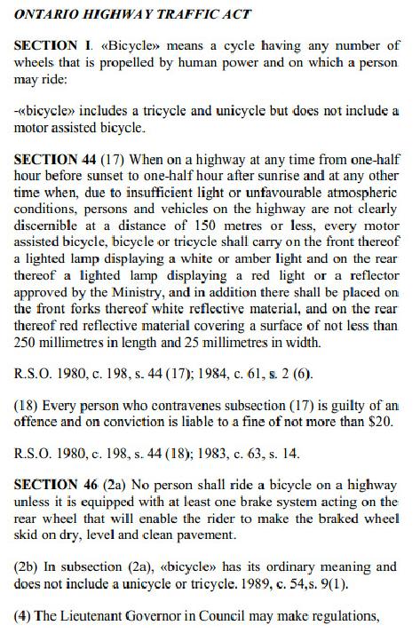
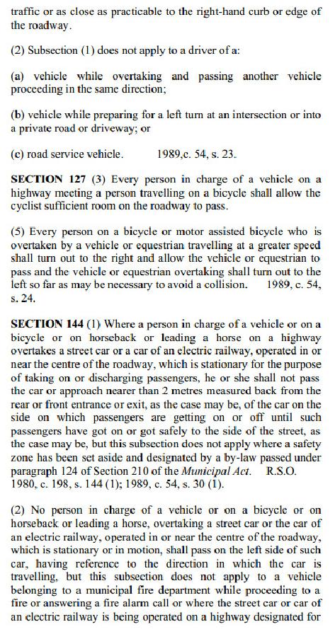
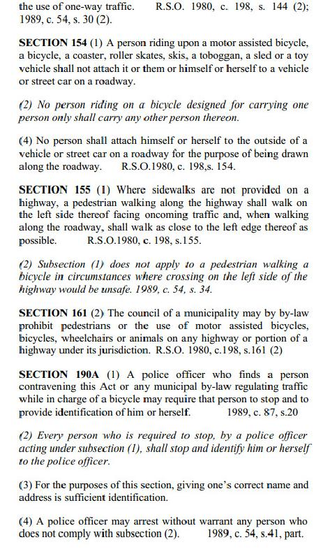
72
Chapter 6: POLICY AND PROCEDURE RECOMMENDATIONS
 Chapter 6 POLICY AND PROCEDURE RECOMMENDATIONS FOR SRRA Below are seven policy elements that should be considered for adoption by the Southwest Regional Recreation Authority of Virginia: 1. Develop strategies
Blueways: Rivers, lakes, or streams with public access for recreation that includes fishing, nature observation, and opportunities for boating.
 Parks, Open Space and Trails PRINCE WILLIAM COUNTY 2008 COMPREHENSIVE PLAN TRAILS PLAN CONTENTS The components of the trails plan are: Intent Definitions Goals, Policies, and Action Strategies Trails Map
DATE: 23 March, 2011 TO: Communities FROM: BlazeSports America. RE: Accessible Trails Checklist 1
 M E M O R A N D U M DATE: 23 March, 2011 TO: Communities FROM: BlazeSports America RE: Accessible Trails Checklist 1 The purpose of the Accessible Trails Checklist (below) is to help the community review
Appendix 3. Greenway Design Standards. The Whitemarsh Township Greenway Plan
 Appendix 3 Greenway Design Standards This chapter discusses two design standards for the greenway types discussed above. First, trail design standards are presented together with trailhead facilities and
The Baker/Carver Regional Trail is intended to
 Section V Design Guidance The Baker/Carver Regional Trail is intended to safely accommodate 183,000 annual visits, an array of non-motorized uses, a variety of skill levels, and persons with special needs.
Committee. Presentation Outline
 CW-33-15 11/9/2015 Community and Corporate Services Committee November 10, 2015 1 Presentation Outline Background Vision and Objectives Study Process and Timeline Public and Stakeholder Engagement Organization
CHAPTER 5 BUILDING TRAILS
 CHAPTER 5 BUILDING TRAILS 5.1 Introduction This section is a compendium of design guidelines based on best practices and covers a wide range of conditions that will typically be encountered during the
Longmont to Boulder Regional Trail Jay Road Connection DRAFT FINAL REPORT
 Longmont to Boulder Regional Trail Jay Road Connection DRAFT FINAL REPORT December 2018 Project Summary Boulder County, Colorado, in partnership with the City of Boulder, is evaluating options for multi-use
City of Durango 5.8 FUNDING TRAILS DEVELOPMENT
 5.8 FUNDING TRAILS DEVELOPMENT The City has been successful in establishing dedicated local funding sources as well as applying for grants to develop the City s trail system, having received nearly $2.4
FEASIBILITY CRITERIA
 This chapter describes the methodology and criteria used to evaluate the feasibility of developing trails throughout the study areas. Land availability, habitat sensitivity, roadway crossings and on-street
Those with Interest in the City of Cambridge Trail System
 Community Services Department City Hall 50 Dickson Street, P.O. Box 669 Cambridge ON N1R 5W8 Tel: 519-740-4681 July 20, 2010 To: Re: Those with Interest in the City of Cambridge Trail System City of Cambridge
MORGAN CREEK GREENWAY Final Report APPENDICES
 APPENDICES MORGAN CREEK GREENWAY Appendix A Photos of Existing Conditions in Trail Corridor Photos of existing conditions Main trail corridor - February 2009 Photos of existing conditions south bank Morgan
Assessing Your Trails, Keeping Them Safe and Enjoyable
 Jon Wood, PLA, ASLA Associate Vice President Stewart Bert Lynn, PLA, ASLA, LEED AP Project Manager Mecklenburg County Asset and Facility Management Assessing Your Trails, Keeping Them Safe and Enjoyable
BACKCOUNTRY TRAIL FLOOD REHABILITATION PROGRAM
 BACKCOUNTRY TRAIL FLOOD REHABILITATION PROGRAM Backcountry Trail Flood Rehabilitation A June 2013 Flood Recovery Program Summary In June 2013, parts of Southern Alberta were devastated from significant
3. COLTA / HUGA CONNECTIONS - PRELIMINARY
 9 3. COLTA / HUGA CONNECTIONS - PRELIMINARY 3.1 COLTA The Chain of Lakes Trail Association (COLTA) trail, formerly identified as the Chester Spur Line, was completed and opened for use in June 2011. The
AGENDA ITEM 5 D WAKULLA ENVIRONMENTAL INSTITUTE (WEI) TRAIL FEASIBILITY STUDY
 TRAIL FEASIBILITY STUDY") March 19, 2018 AGENDA ITEM 5 D WAKULLA ENVIRONMENTAL INSTITUTE (WEI) TRAIL FEASIBILITY STUDY TYPE OF ITEM: Action STATEMENT OF ISSUE The Wakulla Environmental Institute (WEI) Trail is one of several trails
March 19, 2018 AGENDA ITEM 5 D WAKULLA ENVIRONMENTAL INSTITUTE (WEI) TRAIL FEASIBILITY STUDY TYPE OF ITEM: Action STATEMENT OF ISSUE The Wakulla Environmental Institute (WEI) Trail is one of several trails
Non-Motorized Transportation
 Non-Motorized Transportation Non-motorized facilities are important components to the transportation system. They provide an environmentally-friendly, low-cost mode of travel. Some of the facilities can
NEWBORO AND PORTLAND HARBOUR REDVELOPMENT PLANS
 INTRODUCTION The Municipal docks in both Newboro and Portland were transferred to the Township of Rideau Lakes by Parks Canada in 2002. Little has been done to improve the docks physical condition or role
K SIGNAGE & TRAFFIC CONTROL. Table of Contents
 Table of Contents K1. ACCOMMODATION OF TRAFFIC... 1 K2. MINIMUM CONSTRUCTION SIGNING... 1 K3. SUBDIVISION SIGNS... 2 K4. TRAFFIC CONTROL DEVICES... 2 K4.1 Traffic Signs Regulations... 2 K4.2 Materials...
FINCH HYDRO CORRIDOR TRAIL PROJECT
 FINCH HYDRO CORRIDOR TRAIL PROJECT Pharmacy Avenue to Birchmount Road January 29 th, 2018 L Amoreaux Community Centre (2000 McNicoll Avenue) 1 Purpose of Drop In Event The purpose of today s drop-in event
3.0 LEARNING FROM CHATHAM-KENT S CITIZENS
 3.0 LEARNING FROM CHATHAM-KENT S CITIZENS An important aspect in developing the Chatham-Kent Trails Master Plan was to obtain input from stakeholders and the general public. Throughout the course of the
Trails Classification Steering Team Alberta Tourism, Parks and Recreation Alberta Sustainable Resource Development Alberta TrailNet Society
 Acknowledgements Alberta Recreation Corridor and Trails Designation Program Alberta Recreation Corridors Coordinating Committee Trails Classification Steering Team Alberta Tourism, Parks and Recreation
APPENDIX D: SUSTAINABLE TRAIL DESIGN. APPENDICES Town of Chili Parks and Recreation Master Plan Update
 APPENDIX D: SUSTAINABLE TRAIL DESIGN APPENDICES Town of Chili Parks and Recreation Master Plan Update Sustainable Trail Construction Sustainable trails are defined by the US Forest Service as trails having
University Region Non-Motorized Plan 2015
 Non-Motorized Transportation Non-motorized facilities are important components to the transportation system. They provide an environmentally-friendly, low-cost mode of travel. Some of the facilities can
Georgetown-Lewes Rail/Trail Study. Rail/Trail Study: Cool Spring to Cape Henlopen State Park New Road Extension (House Resolution No.
 Georgetown-Lewes Rail/Trail Study Rail/Trail Study: Cool Spring to Cape Henlopen State Park New Road Extension (House Resolution No. 47) August 22, 2011 Presentation Outline Background Benefits Statewide
Provincial Railway Technical Standards
 GENERAL: INDEX: The standards and requirements listed in this document are intended for use on provincially regulated railway public grade crossings. These standards are considered the minimum requirements
THRESHOLD GUIDELINES FOR AVALANCHE SAFETY MEASURES
 BRITISH COLUMBIA MINISTRY OF TRANSPORTATION & INFRASTRUCTURE AVALANCHE & WEATHER PROGRAMS THRESHOLD GUIDELINES FOR AVALANCHE SAFETY MEASURES British Columbia Ministry of Transportation & Infrastructure
Auburn Trail / Ontario Pathways Trail Connector Feasibility Study Public Information Meeting Wednesday, August 22, 2012
 Auburn Trail / Ontario Pathways Trail Connector Feasibility Study Public Information Meeting Wednesday, August 22, 2012 Purpose of Feasibility Study Purpose Evaluate the feasibility of constructing a multiuse
PURPOSE AND NEED (CONCURRENCE POINT 1) NEW CANADA ROAD PROJECT FROM STATE ROUTE 1 (U.S. HIGHWAY 70) TO U.S. INTERSTATE 40
 NEW CANADA ROAD PROJECT FROM STATE ROUTE 1 (U.S. HIGHWAY 70) TO U.S. INTERSTATE 40") PURPOSE AND NEED (CONCURRENCE POINT 1) NEW CANADA ROAD PROJECT FROM STATE ROUTE 1 (U.S. HIGHWAY 70) TO U.S. INTERSTATE 40 Project Description The primary purpose of this project is to improve the major
PURPOSE AND NEED (CONCURRENCE POINT 1) NEW CANADA ROAD PROJECT FROM STATE ROUTE 1 (U.S. HIGHWAY 70) TO U.S. INTERSTATE 40 Project Description The primary purpose of this project is to improve the major
Policies, Guidelines, and Standards for Trails in Alberta Highway Rights-of-way
 Policies, Guidelines, and Standards for Trails in Alberta Highway Rights-of-way Author/Presenter, Sean Willis, P.Eng., Transportation Associate, Stantec Consulting Ltd. Co-Author/Presenter, Steve Otto,
Welcome to the future of Terwillegar Park a Unique Natural Park
 Welcome to the future of Terwillegar Park a Unique Natural Park 1 Introduction The Terwillegar Park Concept Plan study will develop an overall concept plan, management objectives and development guidelines
TOURISM & PUBLIC SERVICES RURAL SIGNAGE POLICY
 Policy and Procedures Subject Title: Tourism and Public Services Rural Signage Policy Corporate Policy (Approved by Council): X Policy Ref. No.: ROADS-01-07 Administrative Policy (Approved by CAO): By-Law
1.0 INTRODUCTION Purpose of Trails Master Plan Study Process The Need for Trails in Wilmot... 2
 TOWNSHIP OF WILMOT TRAILS MASTER PLAN Development Services November 2013 TABLE OF CONTENTS cover picture: Christner Trail, New Hamburg 1.0 INTRODUCTION... 1 1.1 Purpose of Trails Master Plan... 1 1.3 Study
Waukee Trailhead Public Art and Amenities Project
 Waukee - Trailhead Public Art and Amenities Project Sponsor Waukee Project Title Waukee Trailhead Public Art and Amenities Project Termini Description ( i.e. Park Avenue to 19th Street) NE Intersection
Port Gamble Shoreline Area Conceptual Trail Proposal
 The North Kitsap Trails Association is pleased to be a partner to the Kitsap Forest and Bay Project and assist Kitsap County, Forterra, Olympic Property Group, Great Peninsula Conservancy and the Port
URBAN DESIGN REPORT. Proposed Residential Development, Old Church Road, Caledon East
 Proposed Residential Development, Old Church Road, Caledon East TABLE CONTENTS: 1.0 DEVELOPMENT 1.1 Introduction-Analysis of Guiding Principles and Documents 1.2 Community Design and Architectural Design
Lafourche Parish Government REQUEST FOR QUALIFICATIONS. Landscape Architectural Services
 Lafourche Parish Government REQUEST FOR QUALIFICATIONS Landscape Architectural Services Bayou Lafourche Parish Multi-Use Path Feasibility Study Phase 1 And Bayou Lafourche Parish Multi-Use Path Feasibility
Design Considerations For Accessible Parks & Trails
 Design Considerations For Accessible Parks & Trails Measuring Up: Campbell River 2008 Dave Calver Consulting City of Campbell River Legacies Now: Measuring Up Design Guidelines Design Considerations for
Lake Apopka Trail Loop Design Guidelines
 November 2002 Prepared for 14908 Tilden Road Winter Garden, FL 34787 Prepared by 140 North Orlando Avenue Suite 295 Winter Park, FL 32789 November, 2002 I. INTRODUCTION...1 II. DESIGN GUIDELINES FOR TRAILS...3
A number of goals were identified during the initial work on this Big Lake Transportation Plan.
 C. Transportation General Background Information Big Lake s transportation system includes all the roads, paths and facilities that allow the movement of private vehicles, trains and planes, as well as
Logo Department Name Agency Organization Organization Address Information 5700 North Sabino Canyon Road
 Logo Department Name Agency Organization Organization Address Information United States Forest Coronado National Forest 5700 North Sabino Canyon Road Department of Service Santa Catalina Ranger District
Strengthening the Ontario Trails Strategy. Report on Consultations and the Environmental Bill of Rights Registry
 Strengthening the Ontario Trails Strategy Report on Consultations and the Environmental Bill of Rights Registry Purpose To report on the feedback and information received through the regional consultations,
Understanding user expectations And planning for long term sustainability 1
 Understanding user expectations And planning for long term sustainability 1 What is a natural surface trail? It can be as simple has a mineral soil, mulched or graveled pathway, or as developed as elevated
Mt. Hood National Forest
 United States Department of Agriculture Forest Service Mt. Hood National Forest Zigzag Ranger District 70220 E. Highway 26 Zigzag, OR 97049 503-622-3191 Fax: 503-622-5622 File Code: 1950-1 Date: June 29,
DRAFT - APRIL 13, 2007 ROUTING STUDY FOR TRAIL CONNECTIONS BETWEEN CALAIS AND AYERS JUNCTION
 DRAFT - APRIL 13, 2007 ROUTING STUDY FOR TRAIL CONNECTIONS BETWEEN CALAIS AND AYERS JUNCTION Abstract The vision for the East Coast Greenway is an off-road urban trail system running from Calais, Maine
Gold Coast. Rapid Transit. Chapter twelve Social impact. Chapter content
 Gold Coast Rapid Transit Chapter twelve Social impact Chapter content Social impact assessment process...235 Existing community profile...237 Consultation...238 Social impacts and mitigation strategies...239
MPRB: Southwest LRT Community Advisory Committee Issues and Outcomes by Location Current to: 12 November 2010
 MPRB: Southwest LRT Community Advisory Committee Issues and Outcomes by Location Current to: 12 November 2010 This is a compilation of issues and outcomes identified by the CAC. It is a work in progress,
Regional Wayfinding Sign Strategy Thurston County Trails 2017
 Regional Wayfinding Sign Strategy Thurston County Trails 2017 Partners: Members and partnering organizations of the Thurston Thrives Community Design Action Team City of Lacey, City of Olympia, City of
Project Planning, Compliance, and Funding
 Project Planning, Compliance, and Funding The plans above offer high level guidance to ensure that the A.T. is managed effectively as a whole unit in a decentralized management structure. Cooperative management
Becker County Trail Routing Feasibility Study
 2016 Becker County Trail Routing Feasibility Study CONNECTING DETROIT MOUNTAIN AND MOUNTAIN VIEW RECREATIONAL AREA TO THE HEARTLAND TRAIL BECKER COUNTY ULTEIG ENGINEERS Contents Acknowledgements...2 INTRODUCTION...3
2. STAKEHOLDER FEEDBACK // What We Heard
 1. QUARRY ROAD TRAIL // Welcome to the Information Session PROJECT DESCRIPTION WHY WE ARE HERE Quarry Road Trail is a popular commuter trail and recreational area for Calgarians. 1. To report citizen feedback
Pattullo Bridge Replacement Project
 Pattullo Bridge Overview This document will: Explain the challenges facing the Pattullo Bridge today Share how we propose moving forward translink.ca PAGE 1 History By Order of the Lieutenant Governor
Traffic Calming Measures
 REPUBLIC OF GHANA MINISTRY OF TRANSPORTATION Ghana Highway Authority Road Safety and Environment Division Traffic Calming Measures Design Guideline Version 1 / July 2007 Traffic Calming Measures Page 2
Discussion Paper: Development of a Plan for Trails on Public Land
 Discussion Paper: Development of a Plan for Trails on Public Land APRIL 2017 The purpose of this Discussion Paper is to summarize the status & issues relating to District trails and feedback to date, and
TRAFFIC CONTROL DEVICES MANUAL FOR WORK ZONES
 TRAFFIC CONTROL DEVICES MANUAL FOR WORK ZONES SUMMARY Work zone activities often create conditions on the travelled way that are hazardous particularly at night when the ability of motorists to see is
Bloor Street West Rezoning Application for a Temporary Use By-law Final Report
 STAFF REPORT ACTION REQUIRED 3741 3751 Bloor Street West Rezoning Application for a Temporary Use By-law Final Report Date: June 12, 2007 To: From: Wards: Reference Number: Etobicoke York Community Council
METROPOLITAN COUNCIL 390 North Robert Street, St. Paul, MN Phone (651) TDD (651)
 TDD (651)") METROPOLITAN COUNCIL 390 North Robert Street, St. Paul, MN 55101 Phone (651) 602 1000 TDD (651) 291 0904 DATE: June 19, 2007 TO: Metropolitan Parks and Open Space Commission FROM: Jan Youngquist, Senior
METROPOLITAN COUNCIL 390 North Robert Street, St. Paul, MN 55101 Phone (651) 602 1000 TDD (651) 291 0904 DATE: June 19, 2007 TO: Metropolitan Parks and Open Space Commission FROM: Jan Youngquist, Senior
WASHINGTON STATE PARKS AND RECREATION COMMISSION POLICY/PROCEDURE
 WASHINGTON STATE PARKS AND RECREATION COMMISSION POLICY/PROCEDURE 65-13-1 Use of Other Power-Driven Mobility Devices by Persons with Mobility Disabilities at State Park Facilities See Also: 28 CFR 35 Title
Trans Canada Trail Signage Guidelines MADE BY CANADA
 Trans Canada Trail Signage Guidelines MADE BY CANADA Mission: We will promote and assist in the development and use of the Trans Canada Trail by supporting success at the local level in the creation of
2. Goals and Policies. The following are the adopted Parks and Trails Goals for Stillwater Township:
 D. PARKS AND TRAILS 1. Introduction Stillwater Township s population is relatively low, with most residents living on rural residences on large lots. The need for active park space has been minimal in
Worksheet: Resolving Trail Use(r) Conflict March 27, 2010
 Conflict March 27, 2010") RI Land & Water Summit Worksheet: Resolving Trail Use(r) Conflict March 27, 2010 John Monroe National Park Service, Rivers & Trails Program 617 223 5049 John_Monroe@nps.gov www.nps.gov/rtca In one sentence,
RI Land & Water Summit Worksheet: Resolving Trail Use(r) Conflict March 27, 2010 John Monroe National Park Service, Rivers & Trails Program 617 223 5049 John_Monroe@nps.gov www.nps.gov/rtca In one sentence,
Rule Governing the Designation and Establishment of All-Terrain Vehicle Use Trails on State Land
 Rule Governing the Designation and Establishment of All-Terrain Vehicle Use Trails on State Land 1.0 Authority 1.1 This rule is promulgated pursuant to 23 V.S.A. 3506. Section 3506 (b)(4) states that an
EXECUTIVE SUMMARY PROGRAM DEVELOPMENT REPORT PURPOSE EXISTING SETTING EXPANDING PARKLAND
 EXECUTIVE SUMMARY PROGRAM DEVELOPMENT REPORT PURPOSE As the culmination of the first phase of the master planning process, this Program Development Report creates the framework to develop the Calero County
A CASE FOR COMPLETING THE JORDAN RIVER PARKWAY: A
 A CASE FOR COMPLETING THE JORDAN RIVER PARKWAY: A safe crossing at 9000 South and 850 West Proposed 9000 South Underpass Parkway Timeline Parkway, Trail, and Tourism Facts Blueprint Jordan River 1971 1973
chapter - Hex Highway Touring Route Hamburg to Strausstown Overview
 chapter - 2 Hex Highway Touring Route Hamburg to Strausstown Overview The on-road Hex Highway automobile and bicycle touring route begins on State Street in downtown Hamburg. The route continues west on
Ouimet Canyon Provincial Nature Reserve. Management Plan
 Ouimet Canyon Provincial Nature Reserve Management Plan NOTE: This document has been scanned and formatted, and therefore is slightly different from the original version. -March 2002 Additional copies
Bradley Brook Relocation Project. Scoping Notice. Saco Ranger District. United States Department of Agriculture Forest Service
 Bradley Brook Relocation Project United States Department of Agriculture Forest Service Scoping Notice White Mountain National Forest February 2011 For Information Contact: Jenny Burnett White Mountain
Snowmobile Trail Signing REF: DNR Trail Signing Handbook
 AWSC FALL WORKSHOP TRAIL SIGNING & MAINTENANCE NOVEMBER 5, 2011 Workshop presenters: Larry Erickson, AWSC Trails Committee Chairman, Iron County Director Dave Peterson, Langlade County Director Snowmobile
CONTENTS. 1 Introduction Always Moving Forward while Building on the Past A Dynamic Destination... 5
 2010 STRUCTURE PLAN - 2 - CONTENTS 1 Introduction... 5 1.1 Always Moving Forward while Building on the Past... 5 1.2 A Dynamic Destination... 5 2 Map A... 6 Exhibition Place and its Neighbours... 7 3 Demonstration
Chorley Park Trail Connection New Design Options. Information Booklet Prepared for June 9, 2014 Public Meeting
 Chorley Park Trail Connection New Design Options Information Booklet Prepared for June 9, 2014 Public Meeting Chorley Park Trail Booklet June 9, 2014 Page 1 of 12 Our Goals for the Chorley Park Trail Connection
Lake Erie Commerce Center Traffic Analysis
 LOCATION: East of NYS Route 5 at Bayview Road Town of Hamburg Erie County, New York PREPARED BY: Wendel Companies 140 John James Audubon Parkway Suite 200 Amherst, New York 14228 January 2012 i ii Table
Calgary River Access Strategy Priority Sites and Proposed Funding
 Calgary River Access Strategy Priority Sites and Proposed Funding CPS2017-0103 ATTACHMENT 2 A total of $7,660,000 (Class 5 estimate) is required to implement all sites within the Calgary River Access Strategy;
Railroad Safety Trail
 2.1 INTRODUCTION AND PROJECT SETTING 2.1 Introduction & Project Setting Introduction This study is the result of a directed effort on the part of the City of San Luis Obispo to carry out previously established
The Vision for the San Juan Islands Scenic Byway
 The Vision for the San Juan Islands Scenic Byway 2 Judd Cove, Orcas Island, Courtesy of Kurt Thorson (kurtthorson.com) and San Juan County Land Bank Vision for the San Juan Islands Scenic Byway The San
Citrus Heights Creek Corridor Trail Project Trail Advisory Group Field Trip #2 September 11, :00 11:00 am Trellis Hall, Citrus Heights
 September 11, 2013 9:00 11:00 am Trellis Hall, Citrus Heights Project Overview The City of Citrus Heights is studying the feasibility of establishing a multi use trail system within the City s 26 miles
Brampton, Ontario REQ. no.: PLANNING, DESIGN & DEVELOPMENT COMMITTEE
 ftorontoand REGION rv~ Conservation for The Living City May 22,2009 2I22V,5L CFN 42397 CLERK S DEPT. Mr. Peter Fay City Clerk, City of Brampton MAY 2 7 2008 2 Wellington Street West Brampton, Ontario REQ.
Stephanie Sinnott, Executive Director, Finance, Office of the City Manager
 Public Report To: From: Finance Committee Stephanie Sinnott, Executive Director, Finance, Office of the City Manager Paul D. Ralph, BES, RPP, MCIP, Commissioner, Development Services Department Report
The implementation of this Master Plan will be undertaken in logical stages to meet passenger and workforce demands.
 The implementation of this Master Plan will be undertaken in logical stages to meet passenger and workforce demands. Connecting People Building Opportunities 198 Brisbane Airport Corporation CHAPTER 10
Kilometres. Blacktown. Penrith. Parramatta. Liverpool Bankstown. Campbelltown
 0 5 10 15 20 Kilometres Penrith Blacktown Parramatta Liverpool Bankstown Campbelltown accessibility outcomes Legend Outcomes targeted in Western Sydney are: public transport that is accessible throughout
MARSHALL Subdivision. Township of Springwater, County of Simcoe. Traffic Brief for: Ontario Inc. Type of Document: Final Report
 MARSHALL Subdivision Township of Springwater, County of Simcoe Traffic Brief for: 489469 Ontario Inc. Type of Document: Final Report Project Number: JDE 1521 Date Submitted: October 19 th, 2016 10 / 19
Dufferin Jog Elimination Project
 Project Project Status Update November 14 2007 Project History Planning Alternatives Criteria Measured Project Benefits Structural Configurations Considered Structural Design Considerations The Preferred
FINAL. Bicycle/Pedestrian Feasibility Study City of DeBary Dirksen Drive Trail. Prepared For: Volusia County MPO
 City of DeBary Dirksen Drive Trail FINAL Prepared By: Reynolds, Smith and Hills, Inc. Prepared For: Volusia County MPO September 2007 Table of Contents INTRODUCTION...1 PROJECT PURPOSE AND SCOPE...2 PHYSICAL
20mph Speed Limit Zones
 Traffic Advisory Leaflet 7/91 May 1991 20mph Speed Limit Zones Summary This leaflet illustrates the main steps in the procedures for the implementation of 20mph zones. It provides brief details on: the
2016 Regional Transportation Alternatives Program (TAP) Grant Application
 Grant Application") 2016 Regional Transportation Alternatives Program (TAP) Grant Application PROJECT TITLE: Yelm-Tenino Trail Extension Feasibility Study TRPC use only GENERAL PROJECT INFORMATION Agency or Organization City
2016 Regional Transportation Alternatives Program (TAP) Grant Application PROJECT TITLE: Yelm-Tenino Trail Extension Feasibility Study TRPC use only GENERAL PROJECT INFORMATION Agency or Organization City
IL 390 Station. Wood Dale Open House Summary 5/18/17
 Wood Dale Open House Summary 5/18/17 The first public open house for the Wood Dale Comprehensive Plan took place on May 18 th, 2017. The program was conducted as a fun community event and there were 216
China Creek North Park Upgrades and Glen Pump Station. Park Board Committee Meeting Monday, July 10, 2017
 China Creek North Park Upgrades and Glen Pump Station Park Board Committee Meeting Monday, July 10, 2017 Purpose The purpose of this presentation is to: Share the results of the public engagement processes;
SUMMER VILLAGE OF SILVER SANDS. Municipal Development Plan
 SUMMER VILLAGE OF SILVER SANDS Municipal Development Plan Bylaw 253-2014 Adopted August 22, 2014 Summer Village of Silver Sands Municipal Development Plan Bylaw No. 253-2014 Page 2 1 INTRODUCTION 1.1 SETTING
PRESENTED TO Town of Middlebury, VT. PRESENTED BY VTrans, VHB, Fitzgerald & Halliday, Inc., and Kubricky Construction
 PRESENTED TO Town of Middlebury, VT PRESENTED BY VTrans, VHB, Fitzgerald & Halliday, Inc., and Kubricky Construction Meeting with you today Brian Carpenter, Middlebury Selectboard Chair Jim Gish, Middlebury
At the time, the portion of the line through Eagle County remains wholly under the ownership of Union Pacific Railroad (UP).
.") Chapter 5 The Railroad Corridor as a Trail Corridor The intent of this chapter is to identify how the rail corridor, if available for lease or purchase in all or part, could be incorporated into the core
Chapter 5 The Railroad Corridor as a Trail Corridor The intent of this chapter is to identify how the rail corridor, if available for lease or purchase in all or part, could be incorporated into the core
STITCH TRANSFORMATIVE IDEA 3. SHORELINE STITCH. Re-connect the city to the waterfront and link the east and west Core Circle landscapes
 SHORE STITCH TRANSFORMATIVE IDEA 3. SHORELINE STITCH Re-connect the city to the waterfront and link the east and west Core Circle landscapes 126 LINE PUBLIC WORK 127 TRANSFORMATIVE IDEA 3. SHORELINE STITCH
Walking Track Classification System Parks and Wildlife Service
 Appendix A Walking Track Classification Specifications Walking Track Classification System Parks and Wildlife Service This Walking Track Classification System is the outcome of a review of the track classifications
Procedure for the Use of Power-Driven Mobility Devices on Mass Audubon Sanctuaries 1 September 17, 2012
 Procedure for the Use of Power-Driven Mobility Devices on Mass Audubon Sanctuaries 1 September 17, 2012 Background As part of Mass Audubon s mission to preserve the nature of Massachusetts for people and
CHAPTER III: TRAIL DESIGN STANDARDS, SPECIFICATIONS & PERMITS
 CHAPTER III Trail Design Standards, Specifications & Permits This chapter discusses trail standards, preferred surface types for different activities, permits, and other requirements one must consider
RIVER ACCESS STRATEGY
 RIVER ACCESS STRATEGY The River Access Strategy is a 10-year plan the City of Edmonton is developing to inform future programming, operations and infrastructure improvements that support access to the
[This page has been intentionally left blank]
![[This page has been intentionally left blank]](/thumbs/78/78754521.jpg "[This page has been intentionally left blank]") [This page has been intentionally left blank] Table of Contents Section Page Executive Summary... iii 1.0 Introduction... 1 1.1 Purpose... 1 1.2 Process... 1 1.3 Report Organization... 2 2.0 Existing Context...
[This page has been intentionally left blank] Table of Contents Section Page Executive Summary... iii 1.0 Introduction... 1 1.1 Purpose... 1 1.2 Process... 1 1.3 Report Organization... 2 2.0 Existing Context...
As outlined in the Tatshenshini-Alsek Park Management Agreement, park management will:
 Management Strategy General Strategy The priority management focus for the park is to ensure that its internationally significant natural, cultural heritage and recreational values are protected and that
Table of Contents. page 3 Long term Goals Project Scope Project History. 4 User Groups Defined Trail Representative Committee. 5 Trail Users Breakdown
 Launched April 27th, 2010 1 Table of Contents page 3 Long term Goals Project Scope Project History 4 User Groups Defined Trail Representative Committee 5 Trail Users Breakdown 13 Trail Users Desires 16
Proposal to Redevelop Lower Kananaskis River-Barrier Lake. Bow Valley Provincial Park. Frequently Asked Questions
 Proposal to Redevelop Lower Kananaskis River-Barrier Lake Bow Valley Provincial Park Frequently Asked Questions What is being proposed? What are the details of the proposal? Where is the project area located?
Blue River Trail Master Plan JSA to Town Hall June 2004
 Blue River Trail Master Plan JSA to Town Hall June 2004 Prepared for: Silverthorne Town Council Silverthorne SPORT Committee Department of Recreation and Culture Silverthorne Public Works Silverthorne
Preferred Recreation Recommendations Stemilt-Squilchuck Recreation Plan March 2018
 Preferred Recreation Recommendations Stemilt-Squilchuck Recreation Plan March 2018 Below are the recommended recreation ideas and strategies that package together the various recreation concepts compiled