McGee Creek BCM Course Area Guide Backcountry. Trip Code Team Leader
|
|
|
- Joel Vincent Barton
- 5 years ago
- Views:
Transcription
1 McGee Creek BCM Course Area Guide Backcountry Trip Code Team Leader
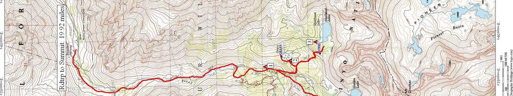
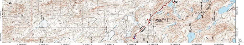
2 Table of Contents Trail Summary... 3 Trail Information... 3 Trail Description... 4 Route Description... 5 Trail Distances... 5 Trail Elevation Profile... 5 Map... 6 Key to Trail Map... 8 Camp Site Information... 8 Map Legend... 9 Hazards... 9 Recommended Destinations Fishing Summits Daily Outline Curriculum Checklist Team Leader Recommendations Team Leader Comments Team Leader Feedback Form Emergency Information BCM Phone Numbers
3 Trail Information Trailhead Name: Trailhead Camp: McGee Creek McGee Creek Campground* *No reservations, first come, first serve Permit (Expiration): Use Code: 153, ID# MLD100013T (8/15/2010) Permit Pick-Up: Special Use Permit is provided in Trip Binder. Wilderness Permit: Please see the Permits-Inyo page in your Team Leader Binder for wilderness permit and pick-up information. Permit Pick-Up: Please see above. Trail Name(s): Type of Trail: Mileage: Alternate Routes: Alternate Mileage: Trail Location: Maps: Flora/Fauna: McGee Creek Trail Out-and-Back miles No information is available. Feedback is great! No information is available. Feedback is great! Inyo National Forest John Muir Wilderness Mammoth Ranger District BCM provides USGS&Trails Illustrated Maps: T.I. #809 (Mammoth Lakes/Mono Divide) USGS Mount Abbot USGS Convict Lake The Laws Field Guide to the Sierra Nevada Sierra Birds: A Hiker s Guide by John M Laws Weather Trends: Average High 82 F / Average Low 40 F 3
4 Trail Description Hiking in California is dry and fast. Beautiful granite slabs make for an easier terrain, great picnic areas and flat, smooth campsites. Expect to hike through pine forests and fields of Manzanita brush. Manzanita, which literally means "little apple" in Spanish, is characterized by orange or red bark and twisting branches. Sometimes Manzanita grow to the height of small trees. The mountain ranges of California are known for their excellent light quality, referred to as alpenglow. When the sun is just below the horizon, a red glow can sometimes be seen on the opposite horizon. Look for alpenglow after sunset or before sunrise, when there is no direct sunlight. Instead, light reflects off airborne snow, water, or ice particles low in the atmosphere. At any time of day, the views above tree line are stunning. During wildflower season, late spring through early summer, expect lots of lupins, paintbrush, columbine, and California poppies. Watch for marmots and pikas--they are everywhere. 4

5 Route Description Overview Hike six miles up to Big McGee Lake and hike eight miles back out, by hiking up to Steelhead Lake to camp. Summit McGee Pass and Red Mountain, if possible. Details The hike up McGee Creek to Big McGee Lake is only six miles, so a simple out-and-back makes for only 12 miles of backpacking. Try to add more mileage and more challenges by camping at Steelhead Lake or Grass Lake, and by doing some fun day hikes should you arrive at camp early. From Big McGee Lake, a hike up to Crocker Lake might be fun and accessible. Campsite-1 to Scheelore Mine: 4.85 miles Campsite-4 to McGee Pass (McGeeP): 1.06 miles McGee Pass to Red Slate Mountain (Red): 0.84 miles Campsite-4 to Red Slate Mountain (Red): 1.79 miles Campsite-3 to Grass Lake: 0.92 miles Trail Elevation Profile* Elevation Gain:7,240 ft. Min. Elevation:8,137 ft. Elevation Loss:7,240 ft. Max. Elevation:13,050 ft. * The elevation details and corresponding graphic pertain to the main route only not alternate routes. 5
6 6
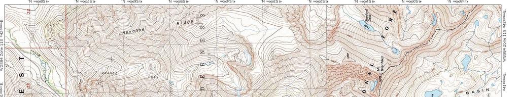

7 7
8 Camp Site Information Favorites 1- McGee Creek - UTM E N 2- Grass Lake (GRASS) - UTM E N 3- Steelhead Lake (STEEL) - UTM E N 4- Little McGee Lake (LAKE) - UTM E N Good Alternative No information is available. Feedback is appreciated! Not Recommended No information is available. Feedback is appreciated! Refer to trail map for corresponding numbered campsites. 8
9 Map Legend Campsites (Not all sites are recommended.) Kitchen area Reported Water Source (River, Pond, Creek, Spring) Portages Point of Interest Hazards Fishing Main Route --- Alternate Routes Points of Interest There is a nice hike up to Horsetail Falls. A pretty canyon at Convict Lake is located between McGee and Mammoth. Shore fishing is also something to be enjoyed. Fishing McGee Creek is running pretty high and is not good for fishing. Stream fishing can be very difficult; fishing is best in lakes. Refer to trail map for corresponding hazards. 9
10 Hazards There is potential rock fall on the road between McGee Campground and McGee pack station. Raining or high winds can push rocks down on the road. Most campsites provide metal lockers. Animals Poisonous Plants Weather Hazards Lightning Exposures No Water Between Scree Slopes Upper eastern Sierra the same animals no food or beverage No information is available. Feedback is appreciated! Raining and high winds run rampant throughout the area. Falling rocks (see above). Intense high altitude sun. Watch for dehydration and heat exhaustion. Afternoon thunderstorms common. Black bears, coyotes, rodents, mosquitoes and ticks. Loose talus. Watch for rock fall and shifting rocks. Early season creeks may not be crossable. Refer to trail map for corresponding locations. 10

11 Summit McGee Pass - UTM E N There are great views from the pass (4 miles round-trip). Red Slate Mountain (RED) - UTM E N This could be another option. Please assess if the route is safe. Try hiking to the peak from McGee Pass. A meadow above Big McGee Lake from McGee Pass Trail. Refer to trail map for corresponding locations. 11
12 Area History These trails travel through national forest and a wilderness area, both public lands, owned by the federal U.S. government and protected from private commerical development, but for different purposes. The initial and continued mission of the National Forest Service, established in 1905 (within the Department of Agriculture), is: "...the greatest good of the greatest number of people in the long run. Focused on conservation, timber and mineral deposits are managed in a manner similar to agriculture or farmed crops. Wilderness Areas were established with preservation in mind. The Congressional Wilderness Act of 1964 was approved to secure for the American people of present and future generations the benefits of an enduring resource of wilderness. As such, Wilderness designation protects the area from roads, logging, oil and gas drilling, and any commercial enterprises. In part, to retain the quiet, motorized and mechanical vehicles and motorized equipment are not allowed. Local Environment The Sierra Nevada Mountains are an uplifted, tilted block of granite 400 miles long by 100 miles wide; the result of fault-line tectonic plate activity. Subsequent erosion, due to streams and glaciers, carved out U-shaped valleys, lakes, rugged peaks and cliffs. Sediment fills lakes creating meadows. There are several threats to the natural condition of the Sierras: air pollution, light pollution, and global warming, evident in the thinning snowpacks. Stray light, particularly from San Joaquin Valley, brightens the night sky. Darkness allows vistors views of the stars, while nocturnal animals depend on darkness to hunt, conceal their location, navigate, and reproduce. Artificial light can disrupt plant cycles. 12
13 Daily Outline Recommendations Expedition Preparation and Planning Day 1 Day 2 Day 3 Day 4 Day 5 Day 6 Day 7 Mcgee Creek Camp IN THE FIELD Camp High Sierra- Site 28 HOME Meet at BCM Office Issue Individual Gear Pre-trip teen surveys Duffle Shuffle Issue BCM Group Gear Camp at McGee Creek Campground Camp along McGee Creek or at Grass Lake. Camp at Big McGee Lake. Summit McGee Pass and Red Mountain if possible, (5 miles roundtrip). Camp at Big McGee Lake. Camp at Steelhead Lake, (4 miles). Hike Out this morning (4 miles) Clean gear Laundry Showers Pick Up Breakfast for Day 7 Evaluations & Surveys (D/A Profile) Celebration Dinner Call office with ETA Coordinate with Youth Leader for how to get teens home. Team Leader debrief with RPM (volunteers welcome, but not required to join.) 13
14 Curriculum Checklist Day 1 Welcome Introductions & Ice Breaker Expectations Policies 7-Day Overview Day 2 Trust Activity Policies Review Daily Activities Quote of the Day Reflection Roundtable Journaling Lessons Lost & Alone Camp Craft 101 LNT Group Travel Food Waste Disposal Campsite Selection Health & Hygiene 201 Cat-Holes Pack Packing Food Protection Water Treatment Lightning Safety Outcomes Set expectations, roles & responsibilities. Establish structure & daily routine. Build Trust. Establish common understanding of trip purpose. Reflect on physical and emotional stresses. Understand one is capable of overcoming & learning from challenges. Work as a team to overcome challenges. Support and encourage each other to overcome challenges. Peak hike: overcome challenges, reflect, and learn from experiences. Celebrate achievement. Create Meaning: How did we overcome challenges? Create Meaning: What are our strengths and weaknesses? Create Meaning: How do we transfer what we have learned home? Setting individual goals for the future. Record learning and achievement in something tactile that teens can take home with them as a reminder of their experience. 14
15 Team Leader Comments This area will be used for free form comments from Team Leaders to future Team Leaders. Please use the Field Journal for feedback and comments. 15
16 Emergency Information Location Base Camp Backcountry (On-Trail) Hospital Mammoth Hospital 85 Sierra Park Rd Mammoth Lakes, CA Services? Yes Local Contact Cell Phone Coverage? BCM Phone Numbers Mammoth Ranger Station 2500 Main St Mammoth Lakes, CA No Emergency Phone Number If an emergency arises on trip that needs immediate assistance, call the emergency number first to reach a BCM staff member. If you do not receive a return call within 20 minutes, refer to the emergency contact sheet you received at the beginning of your trip or directly reach out to BCM staff. Regional BCM office numbers are listed below. Denver Office Chicago Office Pacific NW Office San Francisco Office (cell) (cell) (cell) Additional Emergency Information: Inyo National Forest, 351 Pacu Lane, Suite 200, Bishop, CA Cell Phone Coverage: No information is available. Feedback is appreciated! 16
Rutherford Lake/Fernandez Pass BCM Course Area Guide Backcountry. Trip Code Team Leader
 Rutherford Lake/Fernandez Pass BCM Course Area Guide Backcountry Trip Code Team Leader Table of Contents Trail Summary... 3 Trail Information... 3 Trail Description... 4 Route Description... 5 Trail Distances...
Hetch Hetchy BCM Course Area Guide Backcountry
 Emergency Information Location Hospital Backcountry (On-Trail) Yosemite Medical Clinic Ahwahnee Drive, Yosemite Valley 209.372.4637 8am-7pm drop-in 911 Services? Yes Local Contact Cell Phone Coverage?
Lillian Lakes BCM Course Area Guide Backcountry
 Emergency Information Location Base Camp Backcountry (On-Trail) Hospital 911 Services? Yes Oakhurst Community Medical Center 48677 Victoria Lane Oakhurst, CA 93644 559.683.2992 Local Contact Cell Phone
Lillian Lakes BCM Course Area Guide Backcountry. Trip Code Team Leader
 Lillian Lakes BCM Course Area Guide Backcountry Trip Code Team Leader Table of Contents Trail Summary... 3 Trail Information... 3 Trail Description... 4 Route Description... 5 Trail Distances... 5 Trail
Marvine Creek Trail BCM Course Area Guide Backcountry. Trip Code Team Leader
 Marvine Creek Trail BCM Course Area Guide Backcountry Trip Code Team Leader Table of Contents Trail Summary... 3 Trail Information... 3 Trail Description... 4 Route Description... 5 Trail Distances...
Medicine Bow Trail BCM Course Area Guide Backcountry
 Emergency Information Location Base Camp Backcountry (On-Trail) Hospital Ivinson Memorial Hospital 255 North 30th Street Laramie, WY 82072 Phone: 307.742.2141 Ivinson Memorial Hospital 255 North 30th Street
Marvine Creek Trail. BCM Course Area Guide Base Camp. Colorado Rocky Mountain School Base Camp BCM Denver Office
 Marvine Creek Trail BCM Course Area Guide Base Camp Colorado Rocky Mountain School Base Camp BCM Denver Office Table of Contents Letter from the Regional Program Manager... 3 General Information... 5 Trailhead
McGee Creek. BCM Course Area Guide Base Camp. Camp High Sierra Base Camp BCM San Leandro Office
 McGee Creek BCM Course Area Guide Base Camp Camp High Sierra Base Camp BCM San Leandro Office General Information BCM Headquarters 1667 Vine St. Denver, CO 80206 303.271.9200 www.bigcitymountainers.org
CIEC 9 PEAKS AWARD SUPPLEMENT POSSIBLE ROUTES FOR THE 9 PEAKS AWARD TRIP
 CIEC 9 PEAKS AWARD SUPPLEMENT POSSIBLE ROUTES FOR THE 9 PEAKS AWARD TRIP As you plan your trip, be aware of 3 regulations in this wilderness: 1. Camp only in designated campsites. 2. No campfires allowed.
Itinerary Overview. Sangre de Cristo Alpine Backpacking 22 days Ages Course Description
 Itinerary Overview Sangre de Cristo Alpine Backpacking 22 days Ages 16-18 Course Description Welcome, you re in for an experience of a lifetime! Imagine hiking through rolling forests, sharing alpine meadows
Course Description. Oregon Pacific Crest Trail Backpacking for Adults
 Overview This backpacking course is designed to prepare and train you to tackle the Pacific Crest Trail (PCT) and other long distance hiking trails on your own. It is also designed so that if you desire,
McGee Creek. BCM Course Area Guide Base Camp. College Track of Oakland Girls Expedition 8/5/11
 McGee Creek BCM Course Area Guide Base Camp College Track of Oakland Girls Expedition 8/5/11 BCM San Francisco Bay Area Office Camp Mather, property of San Francisco Recreation and Park General Information
Hiking California's Trinity Alps Wilderness: A Guide To The Area's Greatest Hiking Adventures (Regional Hiking Series) By Dennis Lewon READ ONLINE
 By Dennis Lewon READ ONLINE") Hiking California's Trinity Alps Wilderness: A Guide To The Area's Greatest Hiking Adventures (Regional Hiking Series) By Dennis Lewon READ ONLINE With over 600 miles of trails and 500000 acres of wilderness
Hiking California's Trinity Alps Wilderness: A Guide To The Area's Greatest Hiking Adventures (Regional Hiking Series) By Dennis Lewon READ ONLINE With over 600 miles of trails and 500000 acres of wilderness
White Mountain Wilderness Trails
 The area in which these hikes are located is rugged high mountain country along the Mogollon Rim. This famous eastwest escarpment separates Arizona's high plateau from the basin and range below. These
12-day North Cascades Backpacking Leadership Course Course Location Course Goals
 12-day North Cascades Backpacking Leadership Course The North Cascades form a remote, beautiful and exciting range of glaciated peaks, alpine terrain and rolling forests. Spanning nearly a million acres,
Route Combo) Mt. Bierstadt - Bierstadt, Sawtooth, Evans
 Mt. Bierstadt - Bierstadt, Sawtooth, Evans") Climbing 14ers can be very dangerous, please read the Mountaineering Safety Page and make sure you have a map+compass and can use them effectively, without the help of electronic devices. Route Combo)
Climbing 14ers can be very dangerous, please read the Mountaineering Safety Page and make sure you have a map+compass and can use them effectively, without the help of electronic devices. Route Combo)
Itinerary Overview. Continental Divide Alpine Backpacking 22 days Ages Course Description
 Itinerary Overview Continental Divide Alpine Backpacking 22 days Ages 16-18 Course Description Welcome, you re in for an experience of a lifetime! Imagine hiking through rolling forests, sharing alpine
Itinerary Overview. Sawatch Range Mountaineering Ages days
 Itinerary Overview Sawatch Range Mountaineering Ages 14-16 22 days Course Description Welcome, you re in for an experience of a lifetime! Imagine hiking through rolling forests, sharing alpine meadows
Aconcagua Leadership and Guide Training Course
 Aconcagua Leadership and Guide Training Course Cerro Aconcagua is located in the central Andes of Argentina near the border with Chile. At 22,841ft (6,962m), it is one of the seven summits and the only
YOSEMITE ON HORSEBACK: THREE RIDES ALONG TIOGA ROAD Cindy Casey White Wolf Area, May Lake Loop, Ragged Peak Loop
 YOSEMITE ON HORSEBACK: THREE RIDES ALONG TIOGA ROAD Cindy Casey White Wolf Area, May Lake Loop, Ragged Peak Loop The high country along Tioga Road presents us with some of the most dramatic scenery in
Itinerary Overview: What you will be doing Maroon Bells Alpine Backpacking 22 days
 Itinerary Overview: What you will be doing Maroon Bells Alpine Backpacking 22 days 0BCourse Description Welcome, you re in for an experience of a lifetime! Imagine hiking through rolling forests, sharing
Bradshaw Trails Series
 Bradshaw Trails Series Curtis James Troop 7014 Curtis.James@erau.edu My Motto: Never get lost! Hiking Rules Bradshaw Hiking Patch Series Hiking Tools Hiking Rules Hiking Merit Badge* Take five 10-mile
Itinerary Overview. Maroon Bells Mountaineering 22-days. Course Description
 Itinerary Overview Maroon Bells Mountaineering 22-days Course Description Welcome, you re in for an experience of a lifetime! Imagine hiking through rolling forests, sharing alpine meadows with mountain
LESSON 5 Wilderness Management Case Studies
 LESSON 5 Wilderness Management Case Studies Objectives: Students will: review the key points of the Wilderness Act of 1964. brainstorm solutions for Wilderness management issues. Materials: Í Leave no
Trip Report: Backpack to East Boulder Lake in California Trinity Alps, July 7-9, 2016
 Trip Report: Backpack to East Boulder Lake in California Trinity Alps, July 7-9, 2016 Trekkers: Richard Hales, Aleece Townsend, Carol Mockridge, Rosalie Rybka, Elisabeth Zinser Day 1: Richard and Aleece
Appendix I Case-Studies in Wilderness Management
 Appendix I Case-Studies in Wilderness Management Management Issue Scenarios Note: These scenarios are meant to be used as guidelines for the program leader rather than to be read verbatim. Introduce a
Sierra National Forest
 Sierra National Forest Summer 2018 Wilderness Ranger Intern Application Wilderness Intern Rangers are integral members of the wilderness team working in the Sierra National Forest s spectacular wilderness
Itinerary Overview. Colorado San Juan Mountaineering 15-days
 Itinerary Overview Colorado San Juan Mountaineering 15-days Course Description Welcome, you re in for an experience of a lifetime! Imagine hiking through rolling forests, sharing alpine meadows with mountain
HIKING IN THE CANADIAN ROCKIES
 HIKING IN THE CANADIAN ROCKIES Distance Time Elevation y MORAINE LAKE TRAILS THE ROCKPILE 0.8 km (0.5 mi) 20 min 30 m (98 ft) Located adjacent to the Lodge, the short interpretive trail up the Rock Pile
Trail Beginning Elevation: 7553 ft The Poison Creek Trailhead is located at the end of National Forest Road 646E (NF-646E).
.") West Mountain Trails Poison Creek Trail #134 Length: 2.9 miles (4.7 km) Difficulty Horseback: A good trail for the first time west mountain rider, some steep sections Hiking: Most Difficult USGS Maps:
West Mountain Trails Poison Creek Trail #134 Length: 2.9 miles (4.7 km) Difficulty Horseback: A good trail for the first time west mountain rider, some steep sections Hiking: Most Difficult USGS Maps:
California Section L - Page 1
 64 N. 63 N. 62 N. 725000m 726000m 727000m California Section L - Page 1 728000m 729000m 730000m CA Section L - 38.3 miles Start - Hwy 80 [Donner Summit], mile 1157.1 End - Hwy 49 [near Sierra City], mile
Crystal Lake Area Trails
 Lake Area Trails Welcome to the Lake area of the Big Snowy Mountains! This island mountain range in central Montana features peaks reaching to 8,600 feet and long, high ridges from which vistas of the
L U N C H C R E E K T R A I L GLACIER NATIONAL PARK
 D I R T I N M Y S H O E S L U N C H C R E E K T R A I L GLACIER NATIONAL PARK Lunch Creek "Secret" Hike This short hike on the Lunch Creek Trail will knock your socks off! It's the perfect mix of length,
Itinerary Overview. Yosemite, Joshua Tree & San Francisco Outdoor Educator 65 Days (Fall)
") Itinerary Overview Yosemite, Joshua Tree & San Francisco Outdoor Educator 65 Days (Fall) In General - Wilderness travel is difficult and rewarding. Arriving physically fit will enhance your experience
Itinerary Overview Yosemite, Joshua Tree & San Francisco Outdoor Educator 65 Days (Fall) In General - Wilderness travel is difficult and rewarding. Arriving physically fit will enhance your experience
Santa Barbara Sheriff s Office Date: July 5, 2016 Time: 5:00 p.m.
 Kelly Hoover Public Information Officer (805) 681-4192 Santa Barbara Sheriff s Office Date: July 5, 2016 Time: 5:00 p.m. News Release Sheriff s Search and Rescue Team and SB County Air Support Rescue Bikers
Rutherford Lake/Fernandez Pass
 Rutherford Lake/Fernandez Pass BCM Course Area Guide Base Camps BCM San Leandro Office Tioga High School Base Camp General Information BCM Headquarters 1667 Vine St. Denver, CO 80206 303.271.9200 www.bigcitymountainers.org
Three Sisters Wilderness Oct. 2009
 Three Sisters Wilderness Oct. 2009 I was in Bend, OR and had the whole day to travel back to Boise so I decided to take a hike to the popular Green Lakes and summit the South Sister in Three Sisters Wilderness.
Koroc River Palmer River Loop
 parkscanada.gc.ca Multi-Day Hiking Route Koroc River Palmer River Loop Torngat Mountains National Park T. Knight, Parks Canada 425000m.E. 64 15'0"W 30 64 10'0"W 35 64 5'0"W 40 64 0'0"W 45 63 55'0"W 50
Route #2) Mt. Massive - Southwest Slopes
 Mt. Massive - Southwest Slopes") Route #2) Mt. Massive - Southwest Slopes Difficulty: Class 2 Ski: Advanced, D6 / R2 / III Exposure: Summit Elevation: Trailhead Elevation: Elevation Gain: Round-trip Length: Trailhead: County Sheriff:
Route #2) Mt. Massive - Southwest Slopes Difficulty: Class 2 Ski: Advanced, D6 / R2 / III Exposure: Summit Elevation: Trailhead Elevation: Elevation Gain: Round-trip Length: Trailhead: County Sheriff:
SATURDAY NIGHT LAKE LOOP
 BACKCOUNTRY GUIDE SATURDAY NIGHT LAKE LOOP This trail winds through the hills west of Jasper and visits several small lakes. It can be hiked as a long day or an easy overnight trip. Photo: R Gruys SEMI-PRIMITIVE
List of Challenges. Draw a Map of Your Hike
 List of Challenges Junior Ranger Wildlife Adventures Draw a Map of Your Hike Explore Pella Crossing Hey kids! Do you love animals as much as the Boulder County Park Rangers? Join us on Saturday, June 2
MOUNTAIN BIKING THE CASCADE LOOP
 MOUNTAIN BIKING THE CASCADE LOOP By Henry Freimuth All photographs by Henry Freimuth The Cascades are on the Spanish Creek, which is a tributary of the Feather River. The Feather River was named by Spanish
Non-motorized Trail Plan & Proposal. August 8, 2014
 Town of Star Valley Ranch, Wyoming and the Star Valley Ranch Association in partnership with the USDA Forest Service, Bridger-Teton National Forest, Greys River Ranger District Non-motorized Trail Plan
Itinerary Overview and Travel Information: 15-Day Alaska Alpine Backpacking Course for Adults
 Itinerary Overview and Travel Information: 15-Day Alaska Alpine Backpacking Course for Adults Course Description Welcome, you re in for the experience of a lifetime! Imagine hiking through rolling forests,
Ten Lakes. BCM Course Area Guide Base Camps. BCM San Leandro Office Yosemite National Park Valley School Tioga High School Base Camp
 Ten Lakes BCM Course Area Guide Base Camps BCM San Leandro Office Yosemite National Park Valley School Tioga High School Base Camp General Information BCM Headquarters 1667 Vine St. Denver, CO 80206 303.271.9200
Hike at Pico Blanco Labor Day Weekend!
 Hike at Pico Blanco Labor Day Weekend! The Pico Blanco Hymn Here among the trees majestic Pleasures you will find On the trails of Pico Blanco With your friends and mine Trail the Eagle ever onward This
Oregon Section C - Page 1 WGS84 Zone 10T m
 00 N. 99 N. 98 N. 97 N. 96 N. 557000m Oregon Section C - 74.4 miles Start - Hwy 140, mile 1773.4 (near Fish Lake) End - Hwy 138, mile 1847.8 (near Cascade crest) Elevation Gain +8,111' Elevation Loss -7,145'
Frizzell Creek Ranch Summerville, OR $1,400, ± Acres
 Frizzell Creek Ranch Summerville, OR $1,400,000 165± Acres 1 Introduction The Frizzell Creek Ranch is a beautiful 165± acre ranch located in northeast Oregon at the base of the Wallowa Whitman National
Special Considerations
 BACKCOUNTRY GUIDE SKYLINE An exceptionally beautiful backpacking route: the highest trail in. Photo: R. Bray SEMI-PRIMITIVE 44.1 km, 2-3 day hike Elevation from Maligne Lake: 1410 m gain, 192 m loss Maximum
2019 Work Week Crew. Schedule and Descriptions
 2019 Work Week Crew WAWONA WW1 Mariposa Grove Restoration and Invasive Plant Removal June 2 June 8 YOSEMITE VALLEY YV1 Washington Column Climber s Trail Rehabilitation June 9 June 15 YV2 Weed Warriors/
ROAD AND TRAIL PROJECT APPROVAL
 ROAD AND TRAIL PROJECT APPROVAL www.marincountyparks.org Marin County Parks, 3501 Civic Center Dr, Suite 260, San Rafael, CA 94903 DATE: July 12, 2017 PRESERVE: Gary Giacomini Open Space Preserve PROJECT:
California Section I - Page 1. California Section I miles. WACS0948 may be the last. End - Hwy 108 [Sonora Pass], mile 1016.
![California Section I - Page 1. California Section I miles. WACS0948 may be the last. End - Hwy 108 [Sonora Pass], mile 1016.](/thumbs/89/98421036.jpg "California Section I - Page 1. California Section I miles. WACS0948 may be the last. End - Hwy 108 [Sonora Pass], mile 1016.") California Section I - Page 1 2 8m 2 8m 2 0m 2 91000m 2 92000m 294000m 2 8m 41 9m 41 9m California Section I - 74.4 miles 948 may be the last water northbound until McCabe Start - Hwy 120 [Tuolumne Meadow],
California Section I - Page 1 2 8m 2 8m 2 0m 2 91000m 2 92000m 294000m 2 8m 41 9m 41 9m California Section I - 74.4 miles 948 may be the last water northbound until McCabe Start - Hwy 120 [Tuolumne Meadow],
Kit Carson-Challenger Ridge Trail Project
 Kit Carson-Challenger Ridge Trail Project Project Accomplishments Report-USFS December 15, 2015 Photo courtesy of Justin Peterson 815 South 25 th Street, Suite 101 Colorado Springs, CO 80904 Dedicated
Southern Shenandoah Valley Chapter
 Southern Shenandoah Valley Chapter June 7, 2018 Members of the State Water Control Board c/o Office of Regulatory Affairs, Department of Environmental Quality P.O. Box 1105 Richmond, Virginia 23218 citizenboards@deq.virginia.gov
John Muir Trail: Northbound. 13 Days. to Yosemite
 John Muir Trail: Northbound 13 Days to Yosemite John Muir Trail: Northbound to Yosemite Tackle the northbound half of the John Muir Trail set in California's stunning Sierra Nevada, beginning in Lake Florence
FINAL TESTIMONY 1 COMMITTEE ON RESOURCES UNITED STATES HOUSE OF REPRESENTATIVES. July 13, 2005 CONCERNING. Motorized Recreational Use of Federal Lands
 FINAL TESTIMONY 1 STATEMENT OF DALE BOSWORTH CHIEF Of the FOREST SERVICE UNITED STATES DEPARTMENT OF AGRICULTURE Before the SUBCOMMITTEE ON FORESTS AND FOREST HEALTH And the SUBCOMMITTEE ON NATIONAL PARKS,
24-day Nepal Backpacking Leadership and Guide Training Course
 24-day Nepal Backpacking Leadership and Guide Training Course Course Location Draped along the spine of the Himalaya, Nepal is a land of spectacular scenery, ancient temples, and some of the best trekking
DALHOUSIE WINTER TREKKING EXPEDITION
 DALHOUSIE WINTER TREKKING EXPEDITION Winter Himalayan Trekking Expedition 2016-17 To groom the youngsters in the field of adventures and environmental awareness, Invincible NGO presents the most interactive
TREK THE ROCKIES ABOUT THE CHALLENGE TREK THE ROCKIES FOR HIGHLAND HOSPICE CANADA TREK DEMANDING
 TREK THE ROCKIES CANADA TREK DEMANDING ABOUT THE CHALLENGE The Canadian Rockies are justifiably world-famous for their magnificent scenery: the combination of impressive, jagged mountains, bright turquoise
Resource Typing Template
 Resource Typing Template Resource: Mountain Search and Rescue Categories: Transportation (ESF 1) Communication (ESF 2) Public Works and Engineering (ESF 3) Firefighting (ESF 4) Information & Planning (ESF
MT KILIMANJARO TREK- LEMOSHO ROUTE
 #Trekking MT KILIMANJARO TREK- LEMOSHO ROUTE 10 Days 9 Nights Overview Take the challenging and less-travelled Lemosho route up to the highest peak in Africa, considered by many to be the most beautiful
Hetch Hetchy. BCM Course Area Guide Base Camps. BCM San Leandro Office Yosemite National Park Valley School Tioga High School Base Camp
 Hetch Hetchy BCM Course Area Guide Base Camps BCM San Leandro Office Valley School Tioga High School Base Camp General Information BCM Headquarters 1667 Vine St. Denver, CO 80206 303.271.9200 www.bigcitymountainers.org
Sierra National Forest 2015 Wilderness Program Accomplishment Report
 Sierra National Forest 2015 Wilderness Program Accomplishment Report The Sierra National Forest wilderness program provided stewardship and trail maintenance in the Ansel Adams, Dinkey Lakes, John Muir,
Quandary Peak East Ridge
 Quandary Peak East Ridge Difficulty: Class 1 / 2 June 28,2013 Exposure: Summit Elev.: 14,265 feet Trailhead Elev.: 10,850 feet Elevation Gain: 3,450 feet Roundtrip: 6.75 miles Hikers: Shan Stuart, Rick
USDA TRAILS STRATEGY PROGRAM
 USDA TRAILS STRATEGY PROGRAM WRPI Program: English Peak Survey Jorge D. Briceño Southwestern Community College Internship Time Period: June 6, 2016 August 8, 2016 Advisor: Sam Commarto Recreation Officer
Grizzly Peak A - East Ridge July 15, 2012
 Grizzly Peak A - East Ridge July 15, 2012 Difficulty: Difficult Class 2/Class 3 Upper Elevation: 13,995 feet Trailhead Elevation: 11,360 feet Elevation Gain: 3,000 feet Round-trip Length: 6.0 miles Trailhead:
YMCA Calgary Camp Chief Hector YMCA Summer Camp
 KANANASKIN 12 AND 13Y HECTOR LODGE PROGRAM OPTIONS 12Y Hike 12/13Y Horse 12/13Y Mountain Arts *NEW* 13Y Hike 13Y Canoe Campers in the 12 and 13Y Programs experience a wide variety of camp activities. Through
Figure 1 Understanding Map Contours
 Figure 1 Understanding Map Contours The light brown lines overprinted on topographic maps are called contour lines. They indicate the elevation above sea level of land features and thus permit you to view
Camping Merit Badge Workbook
 Merit Badge Workbook This workbook can help you but you still need to read the merit badge pamphlet. This Workbook can help you organize your thoughts as you prepare to meet with your merit badge counselor.
BROCHURE Sierra Foothills Ranch 55 Acres Pilot Hill, California. Presented by Jim Copeland
 BROCHURE Sierra Foothills Ranch 55 Acres Pilot Hill, California Presented by Jim Copeland 1 The Property This 55 acres is located midway between the historic California gold rush towns of Placerville and
Backpacking Merit Badge Workbook
 Merit Badge Workbook This workbook can help you but you still need to read the merit badge pamphlet. The work space provided for each requirement should be used by the Scout to make notes for discussing
Camp Geronimo Rainbow Trails
 Camp Geronimo Rainbow Trails With over 5,000 acres of surrounding national forest, the possibilities of getting out and seeing the wilderness are almost limitless. Camp Geronimo offers some of the greatest
A Long Weekend in Yosemite. 4 Days
 A Long Weekend in Yosemite 4 Days A Long Weekend in Yosemite On this relaxed yet action-paced 4-day hiking adventure, discover the wildly scenic, glacially sculpted Yosemite Valley, deep in the heart of
Rogue Gorge (Mt. Stella) Roadless Area-- T30S R3E (primarily in portions of Sections 23, 26, 33, 34 & 35)
 Roadless Area-- T30S R3E (primarily in portions of Sections 23, 26, 33, 34 & 35)") Rogue Gorge (Mt. Stella) Roadless Area-- T30S R3E (primarily in portions of Sections 23, 26, 33, 34 & 35) Rogue River-Siskiyou National Forest--High Cascades Ranger District Upper, higher elevation trail
Rogue Gorge (Mt. Stella) Roadless Area-- T30S R3E (primarily in portions of Sections 23, 26, 33, 34 & 35) Rogue River-Siskiyou National Forest--High Cascades Ranger District Upper, higher elevation trail
Proposed Scotchman Peaks Wilderness Act 2016 (S.3531)
") 1 Proposed Scotchman Peaks Wilderness Act 2016 (S.3531) Frequently Asked Questions PLACE Where is the area that would be designated as Wilderness? The lands outlined in S.3531 lie within Idaho along its
1 Proposed Scotchman Peaks Wilderness Act 2016 (S.3531) Frequently Asked Questions PLACE Where is the area that would be designated as Wilderness? The lands outlined in S.3531 lie within Idaho along its
MALIGNE LAKE. In summary. The details BACKCOUNTRY GUIDE SEMI-PRIMITIVE. 22-km paddle to the end of lake Elevation of lake: 1690 m
 BACKCOUNTRY GUIDE MALIGNE LAKE Photo: R Bray SEMI-PRIMITIVE 22-km paddle to the end of lake Elevation of lake: 1690 m In summary Hidden Cove Campground: 4 km Fisherman s Bay Campground: 13 km Coronet Campground:
Mount Daly a Most Prominent Peak via South Ridge
 Mount Daly a Most Prominent Peak via South Ridge Difficulty: Class 3 Exposure: Exposed in places along the ridge Summit Elevation: 13,305 Elevation Gain: 4100 from trailhead; 1800 from Capitol Lake camp
Explore Montana s Glacier National Park!
 Explore Montana s Glacier National Park! Sat-Sat, July 13-20 or July 20-27, 2019 1 P a g e Trailbound Trips Explore. Dream. Discover. Discover: * Stunning hikes * Glacier-studded mountain peaks * Wildlife
Kit Carson-Challenger Ridge Trail Project Annual Performance Report-2014 October 22, 2014
 1 Kit Carson-Challenger Ridge Trail Project Annual Performance Report-2014 October 22, 2014 Willow Lake and Kit Carson Peak 2 SUMMARY The Rocky Mountain Field Institute began Phase 1 of a multi-phase,
Backpacking Merit Badge Workbook
 Merit Badge Workbook This workbook can help you but you still need to read the merit badge pamphlet. The work space provided for each requirement should be used by the Scout to make notes for discussing
Mazatzal Wilderness Trail Maintenance and Exploration
 Mazatzal Wilderness Trail Maintenance and Exploration March 15-19 (Wednesday - Sunday) Difficulty: Beginner Camping: Car Camping Mileage: Wednesday ~4 miles Thursday ~4-6 miles Friday ~4-6 miles Saturday
TAYLOR CANYON RANCH COLORADO - ROUTT COUNTY - STEAMBOAT SPRINGS
 TAYLOR CANYON RANCH COLORADO - ROUTT COUNTY - STEAMBOAT SPRINGS Tucked up against the steep valley shaped by Mt. Pau and rising to the Routt National Forest, Taylor Canyon Ranch is an easily accessible,
Mountain Footsteps. Photo: Ric Carless
 ho: Ric Carless Road Directions Middle White River FS Roads Deep Lake and Driftwood Lake see page 101, Connor Lakes along Maiyuk Creek see page 105, and for access Top of the World rovincial ark see page
AOTA ArtTrek Locations
 AOTA ArtTrek Locations ArtTrek is a summer-long Grand County, CO art adventure. Highlighted by snow-covered mountain vistas and rolling meadows threaded with sparkling streams and rivers, numerous sites
2012 Squaw Butte Trail Warriors
 2012 Squaw Butte Trail Warriors Between June 1 st and September 30 th 2012 Squaw Butte supported nine trail maintenance projects. These projects covered a large section of south western Idaho, taking place
TOPIC = CAMP SITE SELECTION
 TOPIC = CAMP SITE SELECTION I. RESOURCES a. Guide to safe scouting. who can participate and what can they do. trail safety. safety from lightning. b. BSA field book. c. Camping merit badge booklet. d.
Prostate Gathering in the Sierra High Country The Fourth Annual Jan Zlotnick Memorial August 19-24, 2018
 Prostate Gathering in the Sierra High Country The Fourth Annual Jan Zlotnick Memorial August 19-24, 2018 Thank you for your interest in the Fourth Annual Jan Zlotnick Memorial Gathering in the General
April 10, Mark Stiles San Juan Public Lands Center Manager 15 Burnett Court Durango, CO Dear Mark,
 Mark Stiles San Juan Public Lands Center Manager 15 Burnett Court Durango, CO 81301 Dear Mark, We are pleased to offer the following comments on the draft San Juan Public Lands Center management plans
USDA Trails Strategy WRI: ENGLISH PEAK SURVEY. Theodore Mendoza San Diego State University June 6 th 2016 August 18 th Advisor: Sam Commarto
 WRI: ENGLISH PEAK SURVEY Theodore Mendoza San Diego State University June 6 th 2016 August 18 th 2016 Advisor: Sam Commarto Klamath National Forest Submitted: March 21, 2017 Table of Contents Acknowledgements
Oregon Section B - Page m
 Oregon Section B - Page 1 5 35000m 5 36000m 5 37000m 5 38000m 46 57000m 46 58000m Hwy5B - Interstate Highway 5 - mi 1716.4-4271 ft RD1717 - PCT departs paved Old Highway 99 - mi 1716.8-4357 ft PL1717 -
General Skills Task list
 General Skills Task list Name Official Start Completion Trainee Training /s Trainer/s Participate in Candidate Training and get on Peak Adventures payroll Complete Candidate Task List Pay for and attend
Images Made in the Mountains
 IMAGES MADE IN THE MOUNTAINS CHUCK GRAHAM Mountain camp below Mount Tyndall at sunrise in the Eastern Sierra, CA Images Made in the Mountains Chuck Graham I left my truck at 1:00 am at the top of the Whitney
BROCHURE. APPLE HILL WOODS 118 +/- Acres Camino, California. Presented by Jim Copeland
 BROCHURE APPLE HILL WOODS 118 +/- Acres Camino, California Presented by Jim Copeland 1 The Property This 118 acre is a rare gem in the Sierra Nevada foothills. Covered with lush forestland and scattered
26 Utah s Patchwork Parkway SCENIC BYWAY CORRIDOR MANAGEMENT PLAN (SR 143)
") Natural Natural Quality applies to those features in the visual environment that are in a relatively undisturbed state. These features predate the arrival of human populations and may include geological
Natural Natural Quality applies to those features in the visual environment that are in a relatively undisturbed state. These features predate the arrival of human populations and may include geological
Itinerary Overview. Yosemite, Joshua Tree & San Francisco Instructor Development 65 Days (Fall)
") Itinerary Overview Yosemite, Joshua Tree & San Francisco Instructor Development 65 Days (Fall) In General - Wilderness travel is demanding. It can literally take every waking moment to get from point A
Itinerary Overview Yosemite, Joshua Tree & San Francisco Instructor Development 65 Days (Fall) In General - Wilderness travel is demanding. It can literally take every waking moment to get from point A
Drawing Conclusions and Making Inferences
 Drawing Conclusions and Making Inferences G TO THE STUDENT In this book, you will learn how to use the reading strategy called Drawing Conclusions and Making Inferences. With your teacher s help, you will
National Recreation Trail Application for Designation
 National Recreation Trail Application for Designation Introduction Thank you for your interest in the National Recreation Trail (NRT) program. Completed NRT application packages must be submitted by December
2.0 PARK VISION AND ROLES
 2.0 PARK VISION AND ROLES 2.1 Significance in the Protected Area System Marble Range and Edge Hills provincial parks protect 6.8% of the Pavillion Ranges Ecosection, which is located in the Southern Interior
Hiking Las Vegas.com
 Hike: Mt. Wilson via First Creek Canyon route Trailhead: First Creek marked Distance: 10 miles up and back Elevation gain: 3,400 feet Elevation of Peak: 7,070 feet Time: 7 to 9 hours (up and back) Difficulty:
National Recreation Trail Update Form
 National Recreation Trail Update Form Introduction Thank you for taking the time to complete this form. Your assistance will help ensure that the National Recreation Trail (NRT) database is complete and