Dark Sky Observing Sites
|
|
|
- Myles Parker
- 5 years ago
- Views:
Transcription

1 Dark Sky Observing Sites
2 Overview

3 Our Vanishing Stars

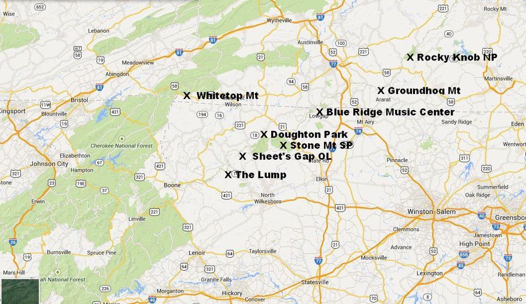
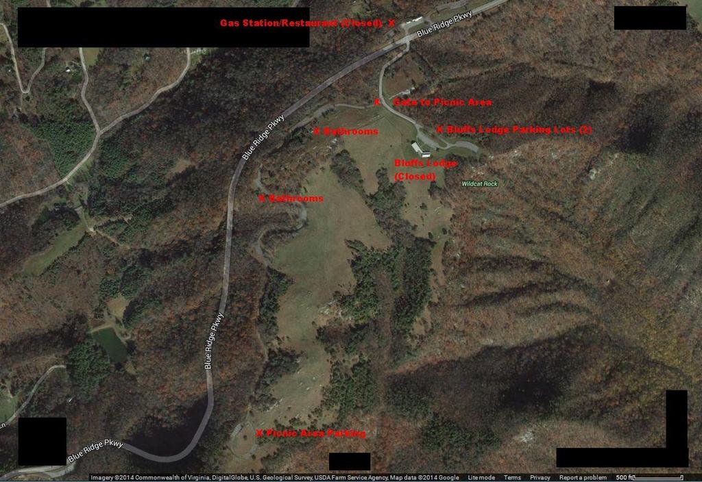
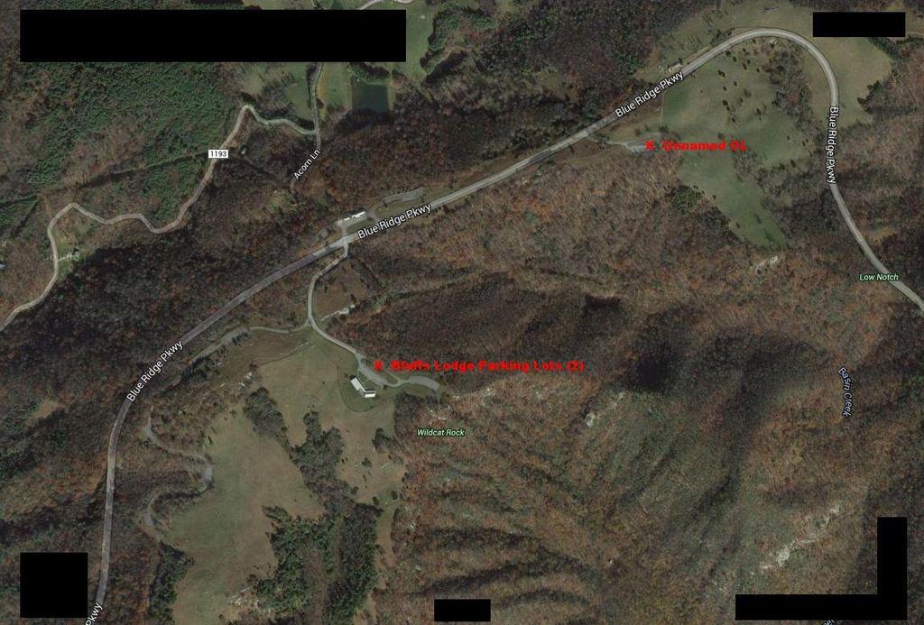
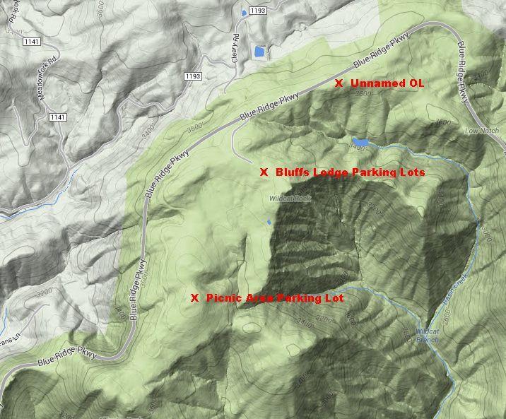
4 Doughton Park
5
6
7
8 Doughton Park Hwy 421 to I-77 North to Hwy 21 North (off I-77 after Yadkin River at Elkin) to BRPkwy South to MP Turn left into the Bluffs Lodge staccess road, then straight ahead to Lodge or 1 right to the Picnic area Can be windy, cold, Most used site 2 Bathrooms open while picnic area is unlocked Picnic are is closed by gate November- early April Campground nearby (in season) Occasionally unavailable in winter when snow gates are closed

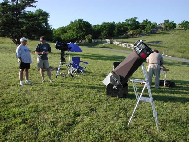
9 Doughton Park

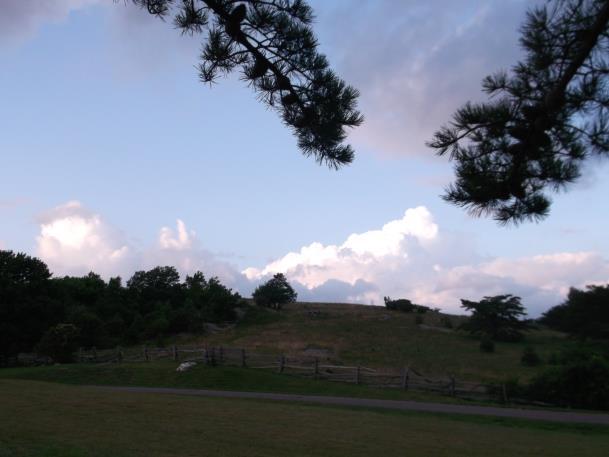
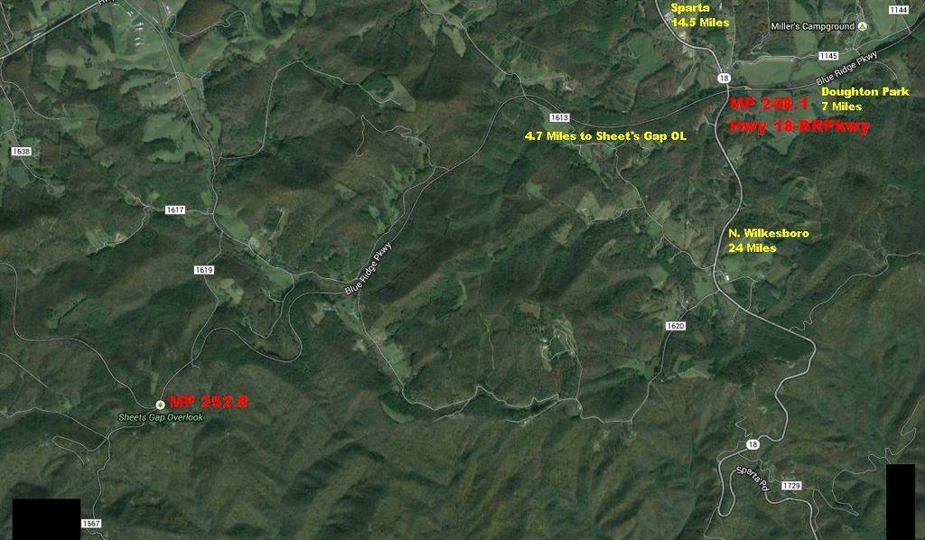
10 Sheet's Gap Overlook MP 252
11
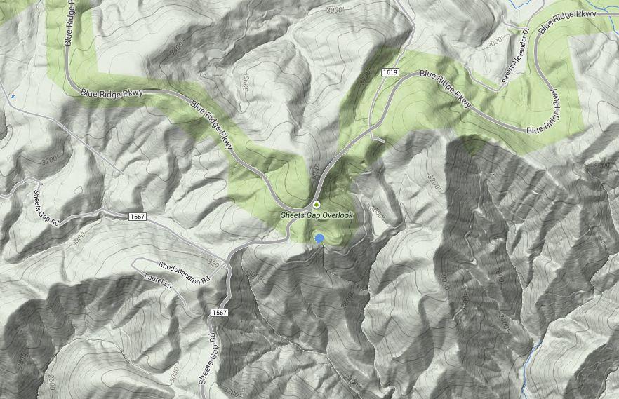
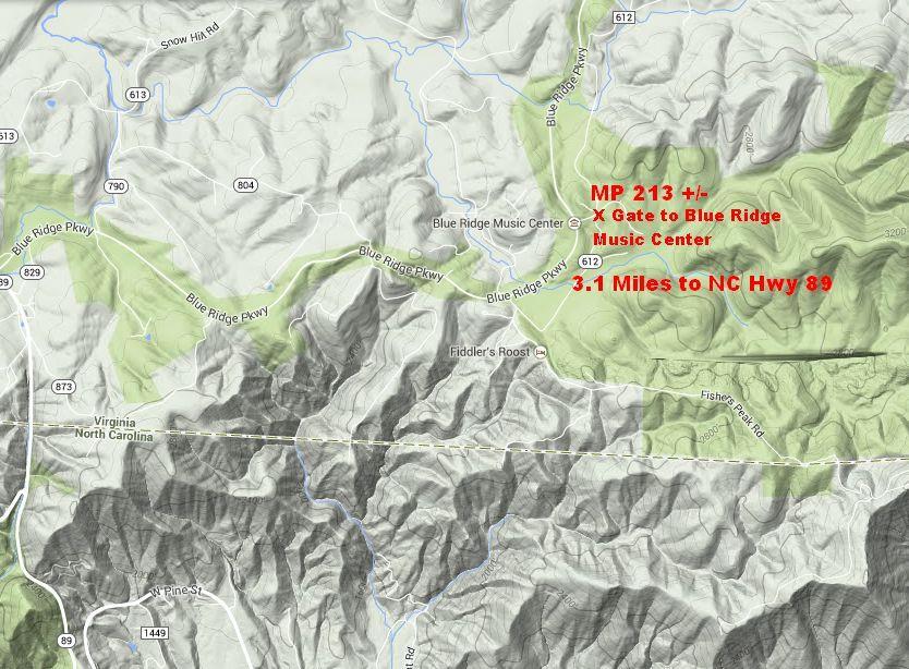
12
13 Sheet's Gap Overlook MP 252 Hwy 421 West to N.Wilkesboro Hwy 18 West to BRPkwy then South 4.7 miles to MP Can Be cold, No facilities, Always open Good Winter site

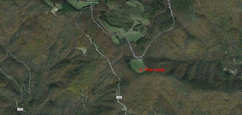
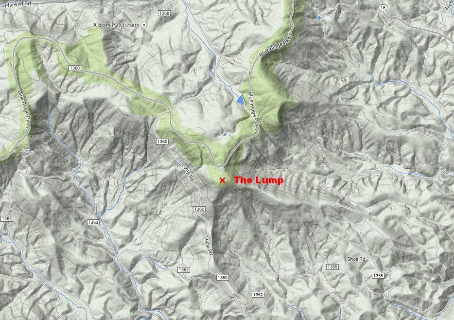
14 The Lump Tom Dooley OL MP 264.4
15
16
17 The Lump Tom Dooley OL MP Hwy 421 West to other side of N. Wilkesboro, right on Hwy 16 to BRPkwy, 3.2 Miles to The Lump/Tom Dooley overlook Can be Cold/Windy, No facilities Glendale Springs Restaurant is nearby (very good) Great views, Great meteor site To go to the top of The Lump itself, requires a short steep hike
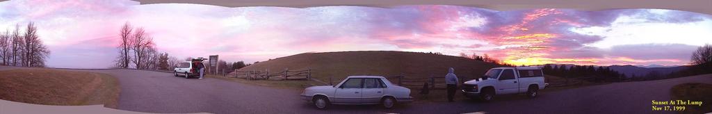
18 The Lump

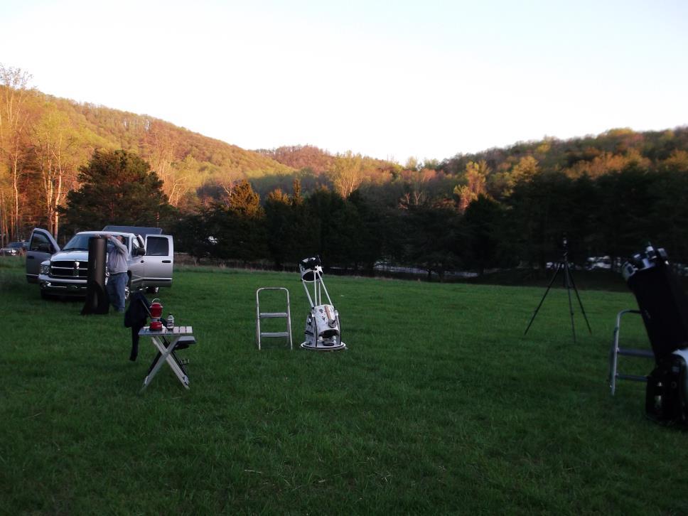
19 Blue Ridge Music Center MP 213
20
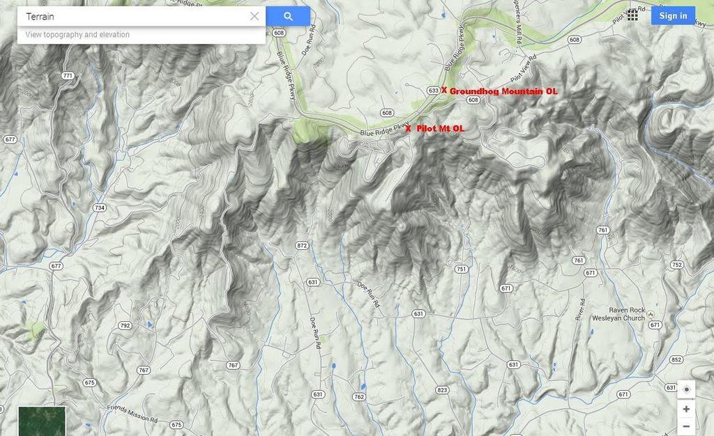
21 Blue Ridge Music Center MP 213 US Hwy 52 N to Mt.Airy, West on Hwy 89 Then N on BRPkwy 3.1 miles to access road Sheltered site, available only when the Blue Ridge Music Center is not open Set up in front of gate on access road from Parkway Good site for everything, but especially photography on windy nights No facilities

22 Stone Mountain SP Campground
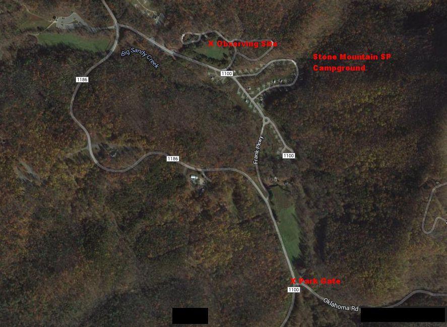
23
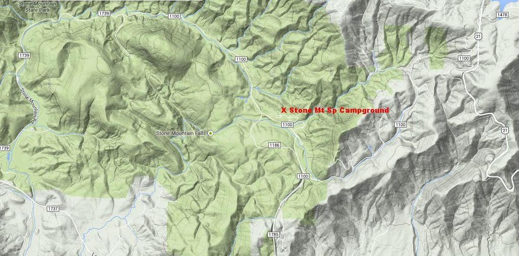
24
25 Stone Mountain SP Campground US Hwy 421 W, I-77 N, Left on Hwy 21(at Elkin) 16 miles to left on Traphill Rd 4.4 miles to right on John P. Frank Parkway 3.3 miles to right into campground, There are signs from Hwy 21 Gate closes at dark Can be very damp, bring dew shields/heaters Heated bathrooms/showers Someone has to bring a cover for septic tank lid Good Trout Fishing (easy access) and Hiking

26 Stone Mountain SP Campground

27 Mt Rogers/Whitetop Mt from Doughton Park

28 Groundhog Mt-Pilot Mt Overlooks
29
30 Groundhog Mt-Pilot Mt Overlooks Hwy 52 N to BRPkwy at Fancy Gap then North 10.8 miles to MP Pilot Mountain OL is just before Groundhog Mountain Restrooms at Groundhog Mt, Not open November-early April Pilot Mt OL can be OK site for meteors

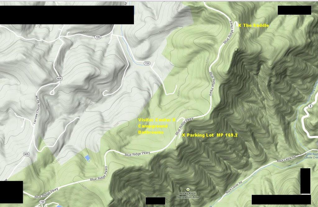
31 Rocky Knob NP MP 169.2
32
33 Rocky Knob NP MP Hwy 52 N to BRPkwy at Fancy Gap, then North on BRPkwy 30.6 Miles to MP Long Trip Campground/Restrooms nearby (In season) The Saddle can be very windy, Parking lot at MP is better

34 Rocky Knob NP MP 169.2

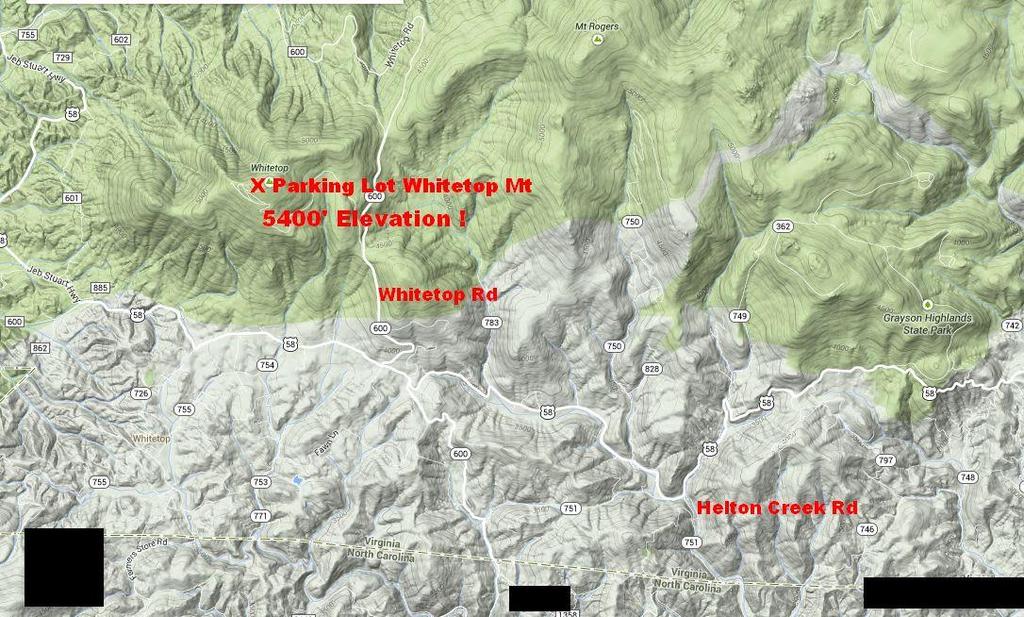
35 Whitetop Mt Mt Rogers/Grayson Highlands SP
36
37

38
39
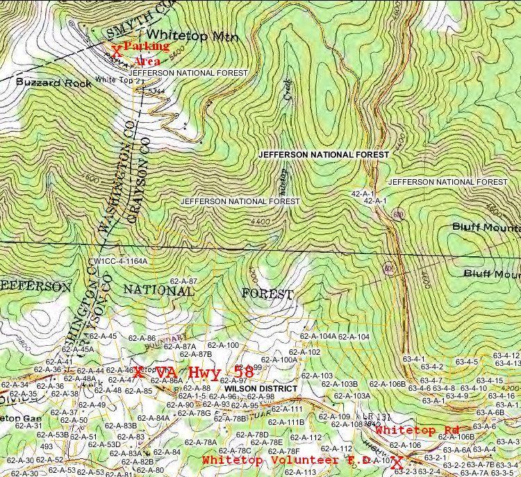
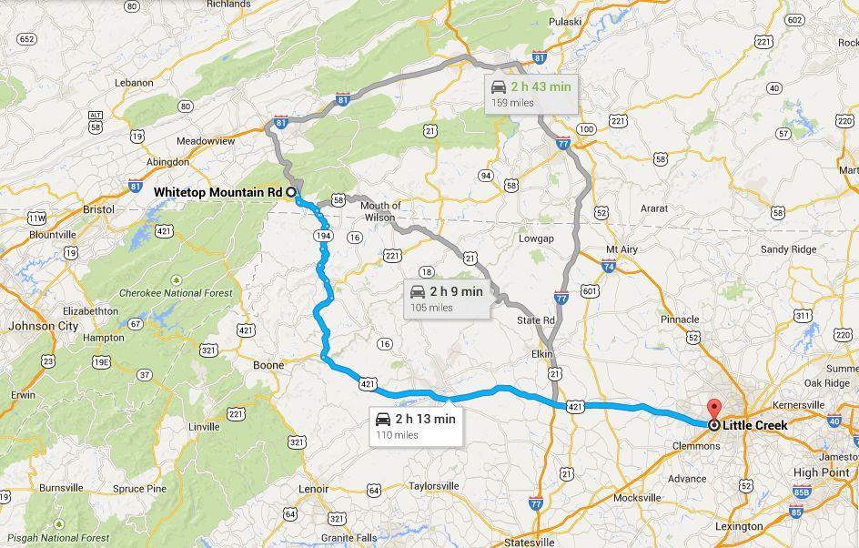
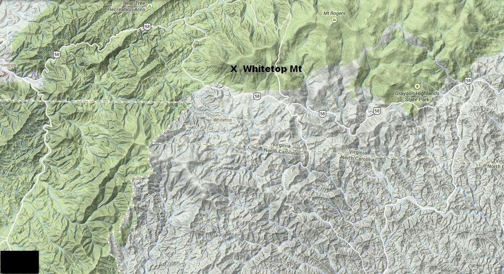
40 Whitetop Mt Mt Rogers/Grayson Highlands SP Hwy 421 west to US Hwy 221 N (just past BRPkwy) to left on Hwy 194. to Sturgills,NC, then left on Helton Creek Rd, then Left on US Hwy 58, then right on Whitetop Rd, then 1.7 miles to left on Mud Creek Rd (gravel) to level gravel parking lot just short of summit One of the best, highest, and darkest sites on the east coast Sky to the North is blocked by the mountain
41 Whitetop Mt Mt Rogers/Grayson Highlands SP Can be very, very cold and windy Over 5400' elevation South side of mountain is cleared 1200'-2000' higher than surrounding mountains No facilities, very long trip (lots of backroads) Stunning views Access road can be rough in places but is quite passable (a long climb, though)
42 Whitetop Mt Mt Rogers/Grayson Highlands SP Mt Rogers/Grayson Highlands SP is nearby Camping and facilities Favorite site for Raleigh Club for camping Mt Rogers is the highest mountain in Virginia (Whitetop is slightly lower) Appalachian Trail trailhead at Whitetop Rd is also a usable site (parking lot at trailhead surrounded by a large meadow on both sides of road)
43


44 Cold Weather Tips 10 degree mph wind night
45 Cold Weather Tips Keep your core warm (hips to shoulders) Dress in multiple layers Get good thermal underwear Good loose fitting shoes/boots, don't crowd toes Hat and gloves (glove liners/light gloves OK if core remains warm Food and warm drinks help (excess carbs can makes you sleepy) Insulated ground layer for meteor observations (meteor observations can be one of the coldest situations you might encounter) I like some synthetic thermals, but not
Asheville & WNC Hikes
 Asheville & WNC Hikes Amazingly, we have 3,000+ miles of free public hiking trails near Asheville, including 1,600 miles in the Pisgah and Nantahala National Forests, 850 miles in Great Smokey Mountains
Blue Ridge Hiking Club Hike List July- September 2016
 Blue Ridge Hiking Club Hike List July- September 2016 Saturday, July 2, Elk Knob: 3.8 mile round trip with 900 ft. gain in elevation. Spectacular views at the summit. The trails are mostly moderate, but
AOTA ArtTrek Locations
 AOTA ArtTrek Locations ArtTrek is a summer-long Grand County, CO art adventure. Highlighted by snow-covered mountain vistas and rolling meadows threaded with sparkling streams and rivers, numerous sites
Blue Ridge Hiking Club - First Quarter 2018 Hikes
 Blue Ridge Hiking Club - First Quarter 2018 Hikes Monday, Jan 1: Trout Lake to Manor House & Figure 8 Trail: Meet at Trout Lake parking lot, at 9:30. (1st exit left off Parkway just south of Cone Manor
The Elkin Valley MST Segment 6
 1 Mountains-to-Sea Trail Last Updated 4/4/2018 Walking the MST into Elkin Photo by Joe Mickey The Elkin Valley MST Segment 6 DEVILS GARDEN OVERLOOK TO PILOT MOUNTAIN STATE PARK By Bob Hillyer This 67-mile
Route #2) Mt. Massive - Southwest Slopes
 Mt. Massive - Southwest Slopes") Route #2) Mt. Massive - Southwest Slopes Difficulty: Class 2 Ski: Advanced, D6 / R2 / III Exposure: Summit Elevation: Trailhead Elevation: Elevation Gain: Round-trip Length: Trailhead: County Sheriff:
Route #2) Mt. Massive - Southwest Slopes Difficulty: Class 2 Ski: Advanced, D6 / R2 / III Exposure: Summit Elevation: Trailhead Elevation: Elevation Gain: Round-trip Length: Trailhead: County Sheriff:
Visitor s Center 110 E. Meeting Street Morganton, NC
 5 unique trails worth checking out! Cross-Country skiing! No snakes! Don t sweat it! www.discoverburkecounty.com Visitor s Center 110 E. Meeting Street Morganton, NC Photo of Table Rock by Justin Costner
CIEC 9 PEAKS AWARD SUPPLEMENT POSSIBLE ROUTES FOR THE 9 PEAKS AWARD TRIP
 CIEC 9 PEAKS AWARD SUPPLEMENT POSSIBLE ROUTES FOR THE 9 PEAKS AWARD TRIP As you plan your trip, be aware of 3 regulations in this wilderness: 1. Camp only in designated campsites. 2. No campfires allowed.
Glacier National Park
 Glacier National Park West Glacier, MO Page 1 Page 3-6 Report Rough Draft Glacier National Park Glacier National Park is located in the northwest corner of Montana and extends into Canada. It is located
Drive and Stop Routes
 Drive and Stop Routes Limantour Road 1 - easy and likely productive. From Bear Valley Visitor Center drive back out and turn left onto Bear Valley Rd. Turn left at Limantour Road (the first road). Drive
Oregon Section B - Page m
 Oregon Section B - Page 1 5 35000m 5 36000m 5 37000m 5 38000m 46 57000m 46 58000m Hwy5B - Interstate Highway 5 - mi 1716.4-4271 ft RD1717 - PCT departs paved Old Highway 99 - mi 1716.8-4357 ft PL1717 -
Prostate Gathering in the Sierra High Country The Fourth Annual Jan Zlotnick Memorial August 19-24, 2018
 Prostate Gathering in the Sierra High Country The Fourth Annual Jan Zlotnick Memorial August 19-24, 2018 Thank you for your interest in the Fourth Annual Jan Zlotnick Memorial Gathering in the General
The High Peaks and Asheville MST Segment 3. PISGAH INN TO BLACK MOUNTAIN CAMPGROUND By Jim Grode
 1 Mountains-to-Sea Trail Last Updated 1/1/2017 Approaching Blackstock Knob Photo by Jeff Clark www.internetbrothers.org The High Peaks and Asheville MST Segment 3 PISGAH INN TO BLACK MOUNTAIN CAMPGROUND
Four Fourteeners in One Day
 Mt. Democrat: Summit: 14, 148 Mt. Cameron: Summit: 14,050 Mt. Lincoln: Summit: 14,286 Mt. Bross: Summit: 14,172 Four Fourteeners in One Day Trailhead: Trailhead Elev.: Total Elevation Gain: Roundtrip:
ADVENTURE GRANDPA BICYCLE TOUR OF COLORADO
 ADVENTURE GRANDPA BICYCLE TOUR OF COLORADO PREPARED FOR BRANDT AND CAMDEN (MY GRANDSONS) June 22-July 1, 2006 June 22 Brent Fisher and I left Houston about 6AM and headed for Wichita Falls where we would
BRR Leg 1 (4.0 miles, Easy)
") BRR Leg 1 (4.0 miles, Easy) Min 3881 Max 4948 Ascent +36 Descent -1027 0.0 Start (Grayson Highlands State Park Visitor Center) 4.0 Grayson Highlands State Park Office & Gate, on L (EZ 1) Leg Notes: Minimal
BRR Leg 1 (4.0 miles, Easy) Min 3881 Max 4948 Ascent +36 Descent -1027 0.0 Start (Grayson Highlands State Park Visitor Center) 4.0 Grayson Highlands State Park Office & Gate, on L (EZ 1) Leg Notes: Minimal
TRAILMARKER. Scott Ridge to Doughton Park. The Piedmont Hiking and Outing Club Newsletter. Since Volume 31 Number 1. January February 2013
 TRAILMARKER The Piedmont Hiking and Outing Club Newsletter January February 2013 Since 1982 Volume 31 Number 1 Scott Ridge to Doughton Park Visit us on the Web http://www.piedmonthikingandoutingclub.org
S H A W A N G U N K R I D G E T R A I L
 214 Shawangunk Ridge Trail The Shawangunk Ridge Trail was originally conceived as a relocation of the Long Path from Harriman State Park to Minnewaska State Park. Now part of the Long Path system, the
NOVEMBER BACKPACKING TRIP Friday, November 2 through Sunday November 4, 2018 Mt. Minsi
 OVERVIEW: This trip is suitable for all Scouts. If you ve never been backpacking, we encourage you to try it. We will be backpacking along the northernmost section of the Appalachian Trail in PA. The first
Staunton River Trail to Hoover Camp and Fork Mtn. Relay Tower (Based on September 18, 2013 hike by Ron Singleton, Fredericksburg, Va.
 Staunton River Trail to Hoover Camp and Fork Mtn. Relay Tower (Based on September 18, 2013 hike by Ron Singleton, Fredericksburg, Va.) The President's Cabin (The "Brown" House) at Camp Hoover. Sign on
Trip Report: Backpack to East Boulder Lake in California Trinity Alps, July 7-9, 2016
 Trip Report: Backpack to East Boulder Lake in California Trinity Alps, July 7-9, 2016 Trekkers: Richard Hales, Aleece Townsend, Carol Mockridge, Rosalie Rybka, Elisabeth Zinser Day 1: Richard and Aleece
Climbing Oak and Brushy Top Mountains
 Climbing Oak and Brushy Top Mountains Story and photographs by Vann Helms www.blueridgeimpressions.org Brushy Top Mountain- February 2, 2014 Brushy top summit After a January of record breaking cold weather,
Best of the Rockies - Jasper Wilderness 7 Days/6 Nights - Detailed Itinerary
 Published on White Mountain Adventures (https://www.whitemountainadventures.com) Home > Best of the Rockies - Jasper Wilderness 7 Days/6 Nights - Detailed Itinerary Best of the Rockies - Jasper Wilderness
(west) onto Charleston Boulevard. Drive 16 miles on Charleston and turn right into Red Rock
 onto Charleston Boulevard. Drive 16 miles on Charleston and turn right into Red Rock") Hike: North Peak and Ice Box Overlook up and back Trailhead: 2.5 miles up the Rocky Gap Road not mark Distance: 5 miles round trip Elevation gain: 2,694 feet Elevation Peak: 7,094 feet Time: 3 to 5 hours
Hike: North Peak and Ice Box Overlook up and back Trailhead: 2.5 miles up the Rocky Gap Road not mark Distance: 5 miles round trip Elevation gain: 2,694 feet Elevation Peak: 7,094 feet Time: 3 to 5 hours
2018 Pioneer Trails KLONDOREE. BSA Camp Alexander - Lake George CO
 FEBRUARY 9TH -11TH 2018 Pioneer Trails KLONDOREE BSA Camp Alexander - Lake George CO Events: Ice Climbing (Age 13+) ~~ Rappelling ~~ Sledding Shooting ~~ Ice Hockey ~~ Archery ~~ and more Registration
Section 7: Pick Up Where You Left Off! S-Tree Road over the Todd Road
 2018 TRACE NOTES Helpful information for your adventure on Section 7 of the Hiker Challenge. Start Point S-Tree Rd. End Point Intersection Todd Rd. / Hale Ridge Rd. WEATHER DECISION Weather Alert!!!! Potential
INFO FOR GROUP LEADERS
 INFO FOR GROUP LEADERS COMMUNICATE EARLY & OFTEN: Let us know ahead of time if your group size has changed or the ages within your group have changed. Also, let us know in advance if your group has any
Three Sisters Wilderness Oct. 2009
 Three Sisters Wilderness Oct. 2009 I was in Bend, OR and had the whole day to travel back to Boise so I decided to take a hike to the popular Green Lakes and summit the South Sister in Three Sisters Wilderness.
Route #1) Mt. of the Holy Cross - North Ridge
 Mt. of the Holy Cross - North Ridge") Climbing 14ers can be very dangerous, please read the Mountaineering Safety Page and make sure you have a map+compass and can use them effectively, without the help of electronic devices. Route #1) Mt.
Climbing 14ers can be very dangerous, please read the Mountaineering Safety Page and make sure you have a map+compass and can use them effectively, without the help of electronic devices. Route #1) Mt.
TROOP FIVE BOY SCOUTS OF AMERICA (
 TROOP FIVE BOY SCOUTS OF AMERICA (http://www.troop5.net) HISTORIC MOUNT WASHINGTON HIKE LOCATION: White Mountain National Forest, New Hampshire DATE: Friday - Monday, June 25-28 th, 2010. TIME: Be at the
Appalachian Trail Conservancy Updates
 Appalachian Trail Conservancy Updates Marian Orlousky Director of Science & Stewardship Appalachian Trail Conservancy morlousky@appalachiantrail.org 1 Food Storage Trends, Challenges, Policy, Guidance
MARIPOSA SUMMIT 6D/5N
 MARIPOSA SUMMIT 6D/5N DAY 1: CUSCO HUAMPOCOCHA We leave Cusco early in the morning, on a private car along the fertile valley of the Vilcanota River, towards Cusipata. After a 2-hour driving trip, we will
Kitimat. Pacific Inland Coast. Hiking Guide Kitimat, British Columbia, Canada
 Kitimat Pacific Inland Coast Hiking Guide Kitimat, British Columbia, Canada 2010-2011 Sites and Trails Emergency Call 911 Police - Fire - Medical 2 Welcome to Kitimat This information was produced to assist
Route Combo) Mt. Bierstadt - Bierstadt, Sawtooth, Evans
 Mt. Bierstadt - Bierstadt, Sawtooth, Evans") Climbing 14ers can be very dangerous, please read the Mountaineering Safety Page and make sure you have a map+compass and can use them effectively, without the help of electronic devices. Route Combo)
Climbing 14ers can be very dangerous, please read the Mountaineering Safety Page and make sure you have a map+compass and can use them effectively, without the help of electronic devices. Route Combo)
Information for Your Stay in Antler s Cabin
 Information for Your Stay in Antler s Cabin Driving Directions Address: 2072 CR 512, Divide, CO 80814 From I-25 in Colorado Springs, take Exit 141 Cimarron St (Hwy 24) and turn left at the at the end of
Washington Section I - Page 1 WGS84 Zone 10T m
 73 N. 72 N. 71 N. 70 N. 69 N. 68 N. These maps are provided as a free service to PCT hikers. I believe the information is accurate but they may contain errors. The maps are distributed in the hope that
BRR Leg 1 (3.9 miles, Easy)
") BRR Leg 1 (3.9 miles, Easy) Min 3901 Max 4919 Ascent +21 Descent -1031 0.0 Start (Grayson Highlands State Park Visitor Center) 3.9 Grayson Highlands State Park Office & Gate, on R (EZ 1) Leg Notes: Minimal
BRR Leg 1 (3.9 miles, Easy) Min 3901 Max 4919 Ascent +21 Descent -1031 0.0 Start (Grayson Highlands State Park Visitor Center) 3.9 Grayson Highlands State Park Office & Gate, on R (EZ 1) Leg Notes: Minimal
Best Places to Explore in NC High Country
 Best Places to Explore in NC High Country Caroline McGuire cmcguire@brri.net (828)773-7276 cell (828)263-8711 ext 240 Tweetsie Railroad-a family friendly Wild West theme park located on Highway 321S between
Berowra Waters to Cowan Station
 Berowra Waters to Cowan Station 3 hrs 30 mins 7.2 km One way Hard track 597m This is a hilly walk out of the beautiful Berowra Waters valley to Cowan Station. There are many wide views across Berowra Creek
Great Eastern Trail Newsletter
 Great Eastern Trail Newsletter Volume 1, Number 1, January 2011 By Timothy A. Hupp Please feel free to print out or copy and distribute this newsletter Note this is the first newsletter of the Great Eastern
GIFFORD PINCHOT NATIONAL FOREST
 GIFFORD PINCHOT NATIONAL FOREST 9341 Wright Meadow 93 Spencer Meadow Spencer Butte 4247' 30 30A 19 24 80 31C Lewis River Lower Falls 5 Quartz Creek 90 Taidnapam Falls Upper Falls 31 Spencer Peak 3861'
playwinterpark.com Off The Beaten Path Hikes Hiking Recommendations for the Adventurous Hiker
 playwinterpark.com Off The Beaten Path Hikes Hiking Recommendations for the Adventurous Hiker Hike: Devil s Thumb (difficult) Length: 3.93 miles one-way Elevation: Trailhead 9609 Destination 12,236 Trailhead
Lava Mountain Trail Distance: Elevation Range: Trail Type: Difficulty: Season: Driving Distance: Driving Time: USGS Maps: Pros Cons
 Lava Mountain Trail Distance: 13.4 miles (including the side trip to North Star Lake) Elevation Range: 5900'-8330' Trail Type: singletrack Difficulty: moderate Season: late June-October Driving Distance:
Driving Time: 3 hours (allow extra time for stops)
") Scenic Byways loop This journey takes visitors through the eastern edge of Mt. Rainier National Park and along two of Washington s most beloved scenic byways, the Chinook Byway and the White Pass Scenic
Scenic Byways loop This journey takes visitors through the eastern edge of Mt. Rainier National Park and along two of Washington s most beloved scenic byways, the Chinook Byway and the White Pass Scenic
Hiking Las Vegas.com
 Hike: Mt. Wilson via First Creek Canyon route Trailhead: First Creek marked Distance: 10 miles up and back Elevation gain: 3,400 feet Elevation of Peak: 7,070 feet Time: 7 to 9 hours (up and back) Difficulty:
OMH Trail Data / History
 Lake Sylvia Loop Ouachita National Forest (AR) This is a five-mile loop with several variations for Saturday hikes. The basic loop starts at Lake Sylvia campground and goes south to meet the Ouachita Trail
Introduction...1 CLOTHING...1 BEDDING DOWN...3 ODDS AND ENDS...4 LAYERED CLOTHING SYSTEM...5 TYPES OF COLD...6 LOSS OF BODY HEAT...
 COLD WEATHER COMFORT & SAFETY Table of Contents Introduction...1 CLOTHING...1 BEDDING DOWN...3 ODDS AND ENDS...4 LAYERED CLOTHING SYSTEM...5 TYPES OF COLD...6 LOSS OF BODY HEAT...7 Introduction Cold weather
Figure 1 Understanding Map Contours
 Figure 1 Understanding Map Contours The light brown lines overprinted on topographic maps are called contour lines. They indicate the elevation above sea level of land features and thus permit you to view
Lost River Retreat Center 2015 Mill Gap Road Lost City, WV (304)
") Lost River Retreat Center 2015 Mill Gap Road Lost City, WV 26810 (304) 897-5935 To make a reservation contact: Hank Dunn 703-869-0376 hank@hankdunn.com The Vienna Baptist Church 541 Marshall Road, SW Vienna,
Lost River Retreat Center 2015 Mill Gap Road Lost City, WV 26810 (304) 897-5935 To make a reservation contact: Hank Dunn 703-869-0376 hank@hankdunn.com The Vienna Baptist Church 541 Marshall Road, SW Vienna,
Leg 1 (4.0 miles, Easy)
") Leg 1 (4.0 miles, Easy) Leg Description: Steady, but controlled downhill (paved). Leg Notes: Great views of the Grayson Highlands balds and mountains. Watch for wild ponies. 0.0 Grayson Highlands State
Leg 1 (4.0 miles, Easy) Leg Description: Steady, but controlled downhill (paved). Leg Notes: Great views of the Grayson Highlands balds and mountains. Watch for wild ponies. 0.0 Grayson Highlands State
Visitor Frequently Asked Questions
 Visitor Frequently Asked Questions Is Pepperwood open to the Public? General access to the preserve is limited to our diverse and frequent public educational and volunteer programs. Unscheduled visits
Sunday / Monday - Osceolas
 AMC August 3, 2015 Sunday / Monday - Osceolas 0 1737 ft 2007, Appalachian Mountain Club. All rights reserved. Notes Created by AMC White Mountain Guide Online wmgonline.org 1 Distance Time Elev Change
Peak to Peak MST Segment 1A
 1 Mountains-to-Sea Trail Last Updated 1/1/2017 Peak to Peak MST Segment 1A View from the Mountains-to-Sea Trail at Clingmans Dome Photo by Danny Bernstein CLINGMANS DOME TO WATERROCK KNOB ALTERNATE ROUTE
Tiger Mountain State Forest:
 98 60 hikes within 60 miles: SEATTLE 20 Tiger Mountain State Forest: West Tiger Mountain Three Loop i KEY AT-A-GLANCE INFORMATION Length: 5.1 miles round-trip Configuration: Loop Difficulty: Moderate difficult
Film Location Prospectus
 Film Location Prospectus NYS Park s Taconic Region in New York s Hudson Westchester, Putnam, Dutchess & Columbia Counties www.parks.ny.gov Janeen M. Martin Marketing/PR Coordinator, Taconic Region 9 Old
Stephens State Park Trails
 TRAILS OF ALLAMUCHY MOUNTAIN & STEPHENS STATE PARKS Allamuchy Mountain and Stephens State Parks contain 28 marked trails providing access to diverse landscapes for walking, hiking, biking, bird-watching,
Beaver Country Trails ATV Jamboree
 Beaver Country Trails ATV Jamboree #1 Lincoln Mine Intermediate (Open to all ATVs/UTVs) 34 Miles Highlights: This ride will highlight the historic Lincoln Mining District, the first lead mine in Utah,
Mahikan District Cub Scout Snow n Do 2015
 Mahikan District Cub Scout Snow n Do 2015 Fun for the Whole Pack! When: Sunday, January 25, 2015 Where: Rotary Scout Reservation East Poestenkill, NY Time: 8:30 am - 2:00 p.m. Cost: $8.00 per person by
Winter Hiking Gear - What to Bring and Wear
 Winter Hiking Gear - What to Bring and Wear These are just my thoughts and suggestions; it is not an all-encompassing checklist. My objective is simply to get everyone to think about this topic and to
Saturday Hike - Hancock Loop & Out
 AMC August 3, 2015 Saturday Hike - Hancock Loop & Out 0 2487 ft 2007, Appalachian Mountain Club. All rights reserved. Notes Created by AMC White Mountain Guide Online wmgonline.org 1 Distance Time Elev
Little Grand Canyon near Pomona, Illinois
 Little Grand Canyon near Pomona, Illinois Below: View of the trail and the terrain created using the Map My Hike app Below: Summary of the hike created using the Map My Hike app Presented by: Jennifer
beach. Make the ford and follow the trail out to the junction with Red Creek Tr in an open grassy area.
 Description: This is a moderate to slightly strenuous 22.8 mile backpack (add 2.6 miles if you do the packless out and back to the Lion s Head) that will have you exploring nearly every thing that is The
ABOUT THE PARKS NANTAHALA NATIONAL FOREST MOUNTAINS NATIONAL PARK CHEROKEE NATIONAL FOREST PISGAH NATIONAL FOREST GREAT SMOKY HIKING TRAILS
 ABOUT THE PARKS GREAT SMOKY MOUNTAINS NATIONAL PARK NANTAHALA NATIONAL FOREST CHEROKEE NATIONAL FOREST PISGAH NATIONAL FOREST GREAT SMOKY MOUNTAINS NATIONAL PARK Straddling the border between North Carolina
TRAILMARKER. After lunch on Bluff Mountain at Doughton Park. The Piedmont Hiking and Outing Club Newsletter. Since 1982
 TRAILMARKER The Piedmont Hiking and Outing Club Newsletter March-April 2012 Since 1982 Volume 30 Number 2 After lunch on Bluff Mountain at Doughton Park Visit us on the Web http://www.piedmonthikingandoutingclub.org
AUSANGATE SUMMIT 9D/8N
 AUSANGATE SUMMIT 9D/8N The mountain region southeast of Cusco, known by locals as the Nudo de Vilcanota, is the second largest glacier system in Peru. Located between the Peruvian departments of Puno and
Ouachita Mountain Hikers (
 Ouachita Mountain Hikers (www.omhikers.net) Click Here to visit us on Facebook Hike Flash September 16, 2018 What's New on the Web Site? The most recent Hike Flash in both desktop and mobile formats may
Guthega to Mt Twynam. 2183m. 1583m. 6 hrs 45 mins 14.8 km Return. Experienced only. 913m
 Guthega to Mt Twynam 6 hrs 45 mins 14.8 km Return Experienced only 5 913m This walk starts from Guthega and makes its way along the Snowy River to the Illawong Lodge, via the Blue Cow Creek flying fox.
Suggested Day Hikes. Mount Greylock State Reservation 3, 4 1, 2. Take a Hike! Things to remember:
 Suggested Day Hikes Mount Greylock State Reservation Take a Hike! This guide offers suggested day hike routes in two parts: 1) Year-round Hikes and 2) Seasonal Hikes (late-may to Nov.1). Use this guide
Class of 1965 Second Annual Winter Trip To The 1965 Cabin at Mount Moosilauke February 12-14, 2018
 Class of 1965 Second Annual Winter Trip To The 1965 Cabin at Mount Moosilauke February 12-14, 2018 1965 Classmates Hank Amon, Rich Beams, Dave Beattie, and Mike Gonnerman spent February 12 14 at the Class
California Section L - Page 1
 64 N. 63 N. 62 N. 725000m 726000m 727000m California Section L - Page 1 728000m 729000m 730000m CA Section L - 38.3 miles Start - Hwy 80 [Donner Summit], mile 1157.1 End - Hwy 49 [near Sierra City], mile
YELLOWSTONE S I G H T S E E I N G I T I N E R A R Y. follow me on
 T H E 4 - D A Y YELLOWSTONE S I G H T S E E I N G I T I N E R A R Y DAY 1 DAY SITE NAME TIME LENGTH OF HIKE/SIGHTSEEING SITE TYPE TIPS/RESOURCES Heart of The Caldera 5 Min. Pull-In Sight Tower Falls 30
Trail Accessibility Guide
 Trail Accessibility Guide Programs and Events The s will make every effort, with two weeks advance notice, to provide reasonable accommodations so that people with disabilities may participate in special
BRYCE CANYON COUNTRY Boulder Mountain Scenic backways itinerary
 BRYCE CANYON COUNTRY Boulder Mountain Scenic backways itinerary Boulder Mountain Area The high plateaus of the Aquarius Plateau (Boulder Mountain), are heavily forested and covered in countless winding
Trail Report for KOKANEE GLACIER PROVINCIAL PARK and other Kootenay Lake Area parks (including west side of Purcell Wilderness Conservancy)
") Updated: October 23, 2017 Please call 250-354-6333 if you have new trail conditions to report. PARK AREA ROADS TRAILS ADDITIONAL INFORMATION Kokanee Creek SPECIAL NOTICE: Trail from Gibson Lake to drainage
Updated: October 23, 2017 Please call 250-354-6333 if you have new trail conditions to report. PARK AREA ROADS TRAILS ADDITIONAL INFORMATION Kokanee Creek SPECIAL NOTICE: Trail from Gibson Lake to drainage
2019 DAY HIKE AT IRON MOUNTAIN SATURDAY, JANUARY 19
 WHERE? In Google Maps, paste the following coordinates for Iron Mountain: 32.978215,-116.972593 or CLICK ON THIS LINK. I. Purpose of the Day Hike A. THE WBC Day Hike is a relatively short trail hike to
Allegheny Trail to Pine Swamp
 16.5 miles, Strenuous, $5.00 carpool fee 62 miles from Roanoke Allegheny Trail to Pine Swamp The hike will start in Monroe County, West Virginia. It begins on WV CR15 at the parking lot for the Hanging
Quandary Peak East Ridge
 Quandary Peak East Ridge Difficulty: Class 1 / 2 June 28,2013 Exposure: Summit Elev.: 14,265 feet Trailhead Elev.: 10,850 feet Elevation Gain: 3,450 feet Roundtrip: 6.75 miles Hikers: Shan Stuart, Rick
Ribbon Cliff - Ribbon Mesa text and photos by Charlie Hickenbottom
 Ribbon Cliff - Ribbon Mesa text and photos by Charlie Hickenbottom Looking for something a little different than Sage Hills or Saddlerock? Perhaps something a little wilder, a little less traveled? Look
Rogue Gorge (Mt. Stella) Roadless Area-- T30S R3E (primarily in portions of Sections 23, 26, 33, 34 & 35)
 Roadless Area-- T30S R3E (primarily in portions of Sections 23, 26, 33, 34 & 35)") Rogue Gorge (Mt. Stella) Roadless Area-- T30S R3E (primarily in portions of Sections 23, 26, 33, 34 & 35) Rogue River-Siskiyou National Forest--High Cascades Ranger District Upper, higher elevation trail
Rogue Gorge (Mt. Stella) Roadless Area-- T30S R3E (primarily in portions of Sections 23, 26, 33, 34 & 35) Rogue River-Siskiyou National Forest--High Cascades Ranger District Upper, higher elevation trail
Grizzly Peak A - East Ridge July 15, 2012
 Grizzly Peak A - East Ridge July 15, 2012 Difficulty: Difficult Class 2/Class 3 Upper Elevation: 13,995 feet Trailhead Elevation: 11,360 feet Elevation Gain: 3,000 feet Round-trip Length: 6.0 miles Trailhead:
SATURDAY NIGHT LAKE LOOP
 BACKCOUNTRY GUIDE SATURDAY NIGHT LAKE LOOP This trail winds through the hills west of Jasper and visits several small lakes. It can be hiked as a long day or an easy overnight trip. Photo: R Gruys SEMI-PRIMITIVE
Hollyford Track Guided Walk 5 day Experience
 Hollyford Track Guided Walk 5 day Experience Overview The Hollyford Track is a fantastic 5 day Fiordland hike from the mountains to the sea at Martins Bay or vice versa. The total track is 56km and accommodation
Garret Mountain Activities and Fees
 Garret Mountain Activities and Fees Fee Statement Picnic Areas 1. Pat DiIanni Boathouse and Picnic Area A prettier scene would be hard to find anywhere in the tri-state area! (a) Suggested Capacity: 50-200
HIKING TRAILS IN THE DAHLONEGA AREA
 HIKING TRAILS IN THE DAHLONEGA AREA 22 Trails in the North Georgia Mountains within 32 miles of Dahlonega Provided by the Dahlonega- Lumpkin County Visitors Center Information compiled and produced by
TAHOE GETAWAY. Monday, October 1 through October 4, 2012
 TAHOE GETAWAY Monday, October 1 through October 4, 2012 COORDINATORS Sue Geisler --- Hiking Dennis Ratay --- Lodging Lodging is now filled. Waiting List: Anyone else interested in participating in the
10/27/2017. Women's Club News October 27, Dear Friends,
 Women's Club News October 27, 2017 View this email in your browser. Dear Friends, Welcome back, snowbirds! It s good to see you again. Aren t you happy to be in Arizona rather than getting your snow shovels
Cub Scout Yukon Adventure
 Twin Rivers Council Fort Orange District Cub Scout Yukon Adventure Saturday, February 4, 2017 At Rotary Scout Reservation 279 Davitt Lake Road Averill Park, NY 12018 Time: 1:00-4:00 PM Cost: $6.00 (pre-registration
Providing active learning experiences and fostering stewardship of the natural world through a tradition of excellence, community, and place.
 Providing active learning experiences and fostering stewardship of the natural world through a tradition of excellence, community, and place. Hello from Denali! Camp Denali & NORTH FACE LODGE Post O!ce
TRAILMARKER. Backpacking Trip on the Appalachian Trail from Sam s Gap to Erwin, TN. The Piedmont Hiking and Outing Club Newsletter Since 1982
 TRAILMARKER The Piedmont Hiking and Outing Club Newsletter Since 1982 July-August 2015 Volume 33 Number 4 Backpacking Trip on the Appalachian Trail from Sam s Gap to Erwin, TN Visit us on the Web http://www.piedmonthikingandoutingclub.org
Special Considerations
 BACKCOUNTRY GUIDE SKYLINE An exceptionally beautiful backpacking route: the highest trail in. Photo: R. Bray SEMI-PRIMITIVE 44.1 km, 2-3 day hike Elevation from Maligne Lake: 1410 m gain, 192 m loss Maximum
Canada Rocky Mountain Adventure Into the Wild
 Canada Rocky Mountain Adventure Into the Wild Itinerary Canada Rocky Mountain Adventure Into the Wild 15 days / 14 nights Calgary Kananaskis Country Spray Lake Canmore Banff Lake Louise Moraine Lake Jasper
Brian Head Singletrack
 DAY 1 After meeting up in St. Geroge, we will shuttle up to the high country to access extraordinary singletrack! After fueling up with a hearty lunch, we ride to the Thunder Mountain Trailhead where the
Mt. Rainier Three-Day Muir Climb
 Mt. Rainier Three-Day Muir Climb Details below provided by AAI Elevation: 14,411 feet Guide Service: Alpine Ascents International (AAI) Fundraising minimum: $5,000.00 USD Muir Three-Day Overview Our three-day
Cannon and the Cannon Balls Traverse with Lonesome Lake
 AMC April 13, 2010 Cannon and the Cannon Balls Traverse with Lonesome Lake 0 1966 ft 2007, Appalachian Mountain Club. All rights reserved. Notes Created by AMC White Mountain Guide Online wmgonline.org
Cold Impacts & Preparedness
 Cold Impacts & Preparedness Potential Impacts Safety Tips Frozen pipes could become a significant problem. Dead car batteries could strand people. Any power outages that occur (weather related or not)
ICEFIELDS TRAIL - CONCEPT
 ICEFIELDS TRAIL - CONCEPT Overview: Municipality of Jasper to Columbia Icefield 1 of 21 2 of 21 3 of 21 226 km Start: Municipality of Jasper Legend KM Marker Roads Proposed trail route 16 Jasper Zone 4
SDTrucksprings. Arkansas Off-roading/4x4 Guide Copyright 2015 We Specialize In:
 SDTrucksprings Arkansas Off-roading/4x4 Guide Copyright 2015 We Specialize In: Helper Springs Air Bags Leaf Springs Body Lift Kits Coil Springs Timbren Kits Hellwig Springs Lift Blocks And More! Visit
Oregon Section F - Page 1 WGS84 Zone 10T m
 08 N. 07 N. 06 N. Oregon Section F - Page 1 WGS84 Zone 10T LavaCampLakeTR - Lava Camp Lake Trail #4060 junction. - mi 1982.6-5287 ft LavaCampLake - Lava Camp Lake, campground, outhouse, 1/2 mile NE of
Dnigi Hut. Dnigi is Dnaina for Moose. Location:
 Dnigi Hut in places. Stay on the main thoroughfare. Continue along the ridge top, going east to a pass above Knob Creek. Just beyond here look for a left turn which descends north-northwest (61,45.578,-148,52.414,2081
THE RESERVE III AT SUGAR MOUNTAIN, NORTH CAROLINA
 THE RESERVE III AT SUGAR MOUNTAIN, NORTH CAROLINA Information Memorandum AUGUST 2015 THE RESERVE III Contents I. THE PROPERTY... 3 OVERVIEW... 3 READY TO BUILD... 4 INEXPENSIVE CONSTRUCTION... 5 ADDITIONAL