REGNART CREEK TRAIL FEASIBILITY STUDY CITY OF CUPERTINO AUGUST 2018 DRAFT
|
|
|
- Jessie Ford
- 5 years ago
- Views:
Transcription


1 REGNART CREEK TRAIL FEASIBILITY STUDY CITY OF CUPERTINO AUGUST 2018 DRAFT
2 THIS PAGE INTENTIONALLY LEFT BLANK DRAFT REGNART CREEK TRAIL
3 TABLE OF CONTENTS 1. EXECUTIVE SUMMARY INTRODUCTION EXISTING CONDITIONS TRAIL CRITERIA PUBLIC OUTREACH TRAIL ALTERNATIVES TRAIL EVALUATION & RECOMMENDATION APPENDICES A. COST ESTIMATES B. RIGHT-OF-WAY DOCUMENTATION C. PUBLIC OUTREACH MEMOS & COMMENTS D. SCVWD MEETING MINUTES E. FEMA MAPS DRAFT HMH
4 THIS PAGE INTENTIONALLY LEFT BLANK DRAFT REGNART CREEK TRAIL
 as being within priority Tiers 2 and 1, respectively, the Regnart Creek Trail is a planned facility which would")


5 EXECUTIVE SUMMARY INTRODUCTION Envisioned as part of The Loop Cupertino and identified in the City of Cupertino 2016 Bicycle Transportation Plan (Bike Plan) and the City of Cupertino 2018 Pedestrian Transportation Plan (Pedestrian Plan) as being within priority Tiers 2 and 1, respectively, the Regnart Creek Trail is a planned facility which would provide a safe and convenient off-street alternative for bicyclists and pedestrians to access nearby destinations including Cupertino Civic Center, Cupertino Public Library, Wilson Park, Creekside Park, nearby schools and residential neighborhoods. Under agreement with the Santa Clara Valley Water District (SCVWD), the project would utilize an existing maintenance road along the bank of Regnart Creek in the City of Cupertino. The project would extend along the existing creek alignment from Pacifica Drive to E Estates Drive where it would connect to the existing trail into Creekside Park. The project would include two upgraded roadway crossings at S Blaney Avenue and E Estates Drive. DRAFT HMH 1


6 EXISTING CONDITIONS The planned alignment is primarily within SCVWD Rights-of- Way, with roadway crossings in City of Cupertino Rights-of- Way. SCVWD, PG&E and AT&T operate facilities within the project area and will require regular maintenance access of the trail alignment. The alignment is adjacent to residential backyards for approximately 2/3 of the project length. A preliminary environmental assessment was performed to identify any biological, ecological, cultural, or other considerations which may restrict the proposed project and to identify potential environmental technical studies to be performed in future project phases. With inclusion of mitigation measures, determined during future study, impacts of the proposed trail project are likely to not be significant. Critical Locations Approximately 800 feet east of S Blaney Avenue, a concrete maintenance ramp exists which is critical for ongoing maintenance of the creek and will be preserved as part of the project. Approximately 500 feet west of S Blaney Avenue, there is an existing drive aisle extending from a cul-de-sac on De Palma Lane providing vehicular access to four De Palma Lane residences. Through this approximately 400 foot long area, the creek-side access road is discontinuous. SCVWD right-of-way extends approximately 15 north of the existing retaining wall through this area. Permission to use this area for bicycle and pedestrian access has been granted to the City by SCVWD through an executed Joint Use Agreement (dated January 20th, 2004 and further amended February 6, 2008). These agreements can be found in Appendix B. PUBLIC OUTREACH The project held four community outreach meetings during the preparation of the Study. Three meetings were noticed to properties within the vicinity of the project and one meeting focused on the Lozano Lane / De Palma Lane residents. Community response to the project was mixed with positive feedback from bicycle/pedestrian advocacy groups and the school community, and strong opposition by residents adjacent to the project. Primary concerns raised pertain to DRAFT safety, security and privacy. The Regnart Creek Trail was included in the Cupertino s draft 2005 General Plan. After public input and discussion at the October 4, 2005 City Council Meeting, a motion carried to remove the Regnart Creek Trail from the 2005 General Plan. 2 REGNART CREEK TRAIL
7 PROPOSED ALIGNMENTS The project considered several alternative alignments which include alignments entirely following the creek, alignments which run through Wilson Park and alignments which partially or fully utilize on-street alternatives along nearby roadways. Alternatives also consider use of bicycle and pedestrian bridges near Wilson Park and enclosing the creek in box culverts near Lozano Lane / De Palma Lane. ALTERNATIVE WEST OF S BLANEY AVE TRAIL ACCESS For alternatives which utilize the existing SCVWD access road, upgraded trailheads utilizing decorative pavements, wayfinding, information boards, seating and other features would be provided. Secondary access points with matching, but less substantial, treatments would be added at other locations for trail user convenience. ROADWAY CROSSINGS With on-creek alternatives, upgraded roadway crossings at both S Blaney Avenue and E Estates Drive were identified in order to safely accommodate trail user crossings at mid-block locations. Treatments including the use of bulbouts, median islands,raised crosswalks, chicanes, rectangular rapid flash beacons (RRFBs), and traffic signals were evaluated at each crossing location. EAST OF S BLANEY AVE BIKE/PED BRIDGE(S) No Build N/A N/A 1 SCVWD Access Road SCVWD Access Road X 2 SCVWD Access Road On-street (Hall Ct.), through Wilson Park & on-street (Vicksburg Dr.) 3 SCVWD Access Road SCVWD Access Road & through Wilson Park & On-street X (Vicksburg Dr.) 4 On-street (Pacifica Dr.) On-street (La Mar Dr.) 5 On-street (Rodrigues Ave.) On-street (Parkside Ln), through Wilson Park, & On-street (Vicksburg Dr.) Table 1.1: Summary of Alignment Alternatives of the Regnart Creek Trail TRAILHEADS Pacifica Avenue / Torre Avenue Intersection DRAFT Rodrigues Ave (at Regnart Creek Bend) Wilson Park SECONDARY ACCESS POINTS Pacifica Drive / Regnart Creek Intersection Cupertino Civic Center (NE corner of Library Field) S Blaney Avenue E Estates Drive Table 1.2: Summary of Regnart Creek Trail Access Locations HMH 3
8 EVALUATION The Study qualitatively evaluated the proposed alignments with respect to its peers using the following evaluation categories: Purpose and Goals of the Bike and Pedestrian Plans Access and Directness User Safety Environmental Considerations SCVWD Maintenance Access Cost Scoring Rubric Alternatives were scored qualitatively using the rubric below: The alternative scores very well as compared to its peers. The alternative scores well as compared to its peers. The scoring of these categories are not weighted equally as some categories (i.e. User Safety) carry more significance than others. RECOMMENDED ALTERNATIVE After evaluation of Alternatives, the Study recommends Alternative 1, a fully creek-side facility, be progressed forward to environmental clearance. This alternative scored well for meeting the goals of the Bike and Pedestrian Plans, for its ability to provide direct and convenient access to nearby destinations and for its safety benefits in separating bicyclists and pedestrians from on-street vehicular conflicts. The alternative scored moderately for cost, environmental considerations and SCVWD maintenance access. No Build Alternative Alternative 1 Alternative 2 Purpose & Goals of Bike & Pedestrian Plans Access & Directness User Safety Environmental Considerations DRAFT The alternative scores moderately well as compared to its peers. The alternative scores slightly well as compared to its peers. The alternative does not score well as compared to its peers. SCVWD Maintenance Access Cost Alternative 3 Alternative 4 Alternative 5 Table 1.3: Summary of Trail Alignment Alternative Evaluations 4 REGNART CREEK TRAIL
.")
9 INTRODUCTION VISION The Regnart Creek Trail is a designated project under the City of Cupertino 2016 Bicycle Transportation Plan (Bike Plan) and the 2018 Pedestrian Transportation Plan (Pedestrian Plan). The purpose of this study is to investigate the feasibility of modifying the existing Santa Clara Valley Water District (SCVWD) access road to allow for the accommodation of a shared-use trail for bicyclists and pedestrians. This trail is one of three off-street trails which comprise the Cupertino Loop Trail (The Loop), which will provide access throughout Cupertino on a series of low stress facilities separated from heavy vehicle traffic. The Loop primarily supports recreational riders and long-range bicycle trips, however subsections of the loop connect local residents to nearby destinations. This project would directly address programming, safety, and mobility goals set forth in the Bike and Pedestrian Plans. The design of a new shared-use trail will address the access needs of people in the area by providing safe passage to schools, parks and civic facilities connected by the trail. Stakeholder agencies associated with the project are the City of Cupertino, Santa Clara Valley Water District, PG&E, and AT&T. Collaboratively, these agencies share goals to create and maintain open-space access for pedestrians and bicyclists through developing joint-use agreements, capital projects, grants, and partnerships. The City of Cupertino envisions an exceptional bicycling environment that supports active living and healthy transportation choices, provides for safer bicycling, and enables people of all ages and abilities to access jobs, schools, recreation, shopping, and transit on a bicycle as a part of daily life. DRAFT Vision statement from the City of Cupertino 2016 Bicycle Transportation Plan (Bike Plan) HMH 5


10 SUNNYVALE REGNART CREEK TRAIL VICINITY SANTA CLARA STELLING RD DE ANZA BLVD WOLFE RD I-280 STEVENS CREEK BLVD MILLER AVE L DRAFT HWY 85. SAN JOSE LEGEND Urban Wildland Proposed Trail Water Way Cupertino City Limits Arterials & Major Roads SARATOGA Figure 2.1 : Regnart Creek Trail Vicinity Map HMH 6
11 BACKGROUND City of Cupertino 2016 Bicycle Transportation Plan In June 2016, the Cupertino City Council adopted the Bike Plan that will guide the development and implementation of improving the City s bicycling environment for years to come. General statements of what the City and residents hope to achieve over time is summarized below. City of Cupertino 2018 Pedestrian Transportation Plan In February 2018, the Cupertino City Council adopted the Pedestrian Plan that will guide the City toward achieving its vision of an inviting, safe, and connected pedestrian network. General statements of what the City and residents hope to achieve over time is summarized below. Increase awareness and value of bicycling through encouragement, education, enforcement, and evaluation programs. Improve bicyclist safety through the design and maintenance of roadway improvements. Increase and improve bicycle access to community destinations across the City of Cupertino for all ages and abilities. Goals stated in the City of Cupertino 2016 Bicycle Transportation Plan (Bike Plan) Improve pedestrian safety and reduce the number and severity of pedestrian related collisions, injuries, and fatalities. Increase and improve pedestrian access to community destinations across the City of Cupertino for people of all ages and abilities. Continue to develop a connected pedestrian network that fosters an enjoyable walking experience. Bikeway Classifications The Bike Plan recommends bikeway treatments that will collectively form a bicycle transportation network and will accommodate the safety needs of all mobility types, users, and ability levels. Class I Shared-Use Paths Class I bicycle or shared-use paths are designated bicycle and pedestrian travel routes that are completely separated from automobile traffic. These facilities provide safe passageways for users and promote local greenspaces. Class I facilities can be popular for recreational bicycling as well as commuting. Class II Bike Lanes Class II bike lanes are bicycle travel routes located along roads and are visually separated from automobile traffic by road striping. Because these roads often connect key businesses and community centers, they are viewed as vital commuter routes for community members. Bike lanes can be further enhanced by green paint, which highlight areas of potential conflict with vehicles. Goals stated in the City of Cupertino 2018 Pedestrian Transportation Plan (Pedestrian Plan) Class III Bike Routes Class III bike routes are roads where automobile and bicycle traffic share travel lanes. Signage and striping are used to indicated the shared condition and travel lanes tend to be wider to allow for parallel travel. These types of paths are often used on slower streets, where parallel travel is safer. DRAFT Class IV Separated Bikeways Class IV separated bikeways are a new type of bicycle travel route located along roads similar to Class II bike lanes, but physically separated by elements such as curbs, planting areas, posts, barriers, parking, and grade separation. The added physical separation provides increased safety for cyclists along higher speed roadways that may serve as commuter routes. HMH 7
, which consists of several trail segments that, when combined together with on-street bikeways, will form a bike network around Cupertino.")
12 The Loop The Bike Plan identified a prioritized list of recommended improvement projects to support and promote bicycling in Cupertino, including separated bikeways, a bike boulevard network, and The Cupertino Loop Trail (The Loop), which consists of several trail segments that, when combined together with on-street bikeways, will form a bike network around Cupertino. THE LOOP Cupertino Cupertino s proposed network of connected bikeways and trails around the City The Regnart Creek Trail is a segment of The Loop that comprises of a shared-use trail along an existing SCVWD maintenance access road. The trail will provide an off-street bicycle and pedestrian connection between Pacifica Drive to the west, and E. Estates Drive, to the east. Agencies & Stake Holders The City is sensitive to the needs of partner agencies. Of particular concern are creek erosion, degradation of the environment, impacts to conveyance of flood flows, and restrictions to access for maintenance equipment and related activities. Early and continued engagement with partner agencies is needed to support on-going trail development. THE STUDY The purpose of the feasibility study is to define the project, identify major constraints and assess the feasibility of developing the 3/4 mile shared-use facility along Regnart Creek between Pacifica Drive and E Estates Drive. The study evaluated alternatives to identify preferred alignments, access points and trail features in consideration of constraining factors and the goals set forth by the Bike and Pedestrian Plans. Upon Council approval, potential next steps and project development phases include: Approval of Regnart Creek Trail by City Council, Identification of potential funding sources, Environmental clearance, Preliminary Engineering, Local, State, and Federal Permitting, Final Design, Construction DRAFT PG&E owns and operates three utility poles along Regnart Creek within the SCVWD right-of-way which support electric and communication facilities. PG&E and AT&T have a joint utility easement and rights of ingress and egress to Regnart Creek in order to maintain their facilities. Throughout design and construction of the trail, careful consideration shall be taken to protect these existing utilities and preserve PG&E and AT&T s rights to accessibility and maintenance. 8 REGNART CREEK TRAIL
")
13 Figure 2.2: Cupertino Loop Trail (The Loop) from the Bike Plan HMH 9 DRAFT
14 THIS PAGE INTENTIONALLY LEFT BLANK DRAFT REGNART CREEK TRAIL

15 EXISTING CONDITIONS LAND USE AND ZONING Land Use The Regnart Creek Trail alignment resides approximately onequarter mile from the Heart of the City, Cupertino s primary commercial corridor comprised of various older and newly developed commercial, office, and residential amenities. Spanning from Pacifica Drive to E Estates drive, along Regnart Creek, the trail meanders through the S Blaney neighborhood adjacent to 82 single-family residences. The South Blaney neighborhood is located in the eastern portion of Cupertino, south of Stevens Creek Boulevard and east of De Anza Boulevard. This area is predominately defined by single-family residential homes. Bounded by Bollinger Road, Miller Avenue, De Anza Boulevard, and Stevens Creek Boulevard, the area is served by the Cupertino Civic Center, Wilson Park, Creekside Park, and Eaton Elementary School. Zoning The zoning designations in the proximity of the study are: R1-7.5: Single Family Residential District Minimum lot area is 7500 SF P(BA): BA Public Building For regulating governmental, public utility, education, religious, and transportation facilities Owned or utilized by federal, state, county, or city government R1C: Residential Single-Family Cluster Reduces amount of street improvements and public utilities to conserve natural features and provide more desirable aesthetic and efficient use of open space DRAFT PR: Park and Recreation Zone For regulating activities within public owned parks Figure 3.1: S Blaney Neighborhood Land Use Diagram from Cupertino s General Plan HMH 10


16 EXISTING BICYCLE FACILITIES Cupertino has an ideal setting to use bicycles for commuting, utility, and recreational purposes. According to the Bike Plan, the City currently accommodates its ridership through a vast bikeway network which includes almost five miles of Class I shared-use paths, twenty-seven miles of Class II bike lanes, and nine miles of Class III bike routes. Approximately 25 percent of Cupertino s roadway network contains bicycle facilities. Stevens Creek Boulevard, approximately 0.2 miles north of the Regnart Creek Trail, is a major east/west arterial corridor with high volumes and vehicular speeds. Stevens Creek Boulevard contains Class II bike lanes in both directions; however, the Bike Plan identifies upgrades to existing facilities through the implementation of Class IV separated bikeways along this corridor. De Anza Boulevard, approximately 900 ft west of the Regnart Creek Trail, is a major north/south arterial corridor with high volumes and vehicular speeds. De Anza Boulevard contains Class II bike lanes in both directions. Per the Bike Plan, the City plans to enhance these bike lanes with buffers and upgraded paint markings. The City is currently implementing Class IV bikeways along McClellan Road and Stevens Creek Boulevard. These projects will install vertical separation between bikes and vehicles along McClellan Road from Byrne Ave to S De Anza Boulevard, along Rodrigues Ave from Terry Way to Regnart Creek, and along Stevens Creek Boulevard from N Tantau Avenue to Wolfe Road. The Regnart Creek Trail alignment is also adjacent to Class II bike lanes on South Blaney Avenue, Rodrigues Avenue, and Bollinger Road. Photo 3.1: Existing trail in Cupertino Photo 3.2: Existing bike lanes in Cupertino DRAFT Photo 3.3: Class IV bike lane rendering in Cupertino 11 REGNART CREEK TRAIL


17 ACTIVITY GENERATORS The area surrounding the Regnart Creek Trail alignment contains several schools, parks, residences, retail, and municipal buildings. The addition of a trail would offer an off-street alternative for students and residents to various destinations near the creek. Parks & Fields Library Field Includes cricket field and large, open grass area for various sports. Wilson Park Wilson Park is adjacent to the trail and includes a recreation building, family picnic areas, fitness course, play equipment, ceramics center, baseball fields, and soccer field. Creekside Park Creekside Park is adjacent to the trail and includes a field, family picnic areas, half-court basketball, playground areas, soccer fields, bicycle/pedestrian bridge over Calabazas Creek, and community room. Schools Eaton Elementary School 0.1 miles from the trail Cupertino High School 0.3 miles from the trail Sedgwick Elementary School 0.3 miles from the trail Commercial and Retail Various Locations 0.2 miles from the trail McClellan Square 0.2 miles from the trail Cupertino Civic Center The Civic Center is adjacent to the western portion of the trail. City Hall Community Hall Cupertino Library DRAFT Photo 3.4: Cupertino High School Photo 3.5: Wilson Park Photo 3.6: Cupertino City Hall HMH 12
18 PACIFICA DR. ACTIVITY GENERATORS proposed trail religious center higher education retail/shopping high-density housing city government community center K-12 public park HMH 13 MILLER AVE. DE ANZA BLVD. TORRE AVE. BLANEY AVE. city hall & civic center RODRIGUES AVE. cupertino library library field STEVENS CREEK BLVD. the biltmore apartments wilson park creekside park eaton elementary school Figure 3.2: Activity Generators near the Regnart Creek Trail cupertino high school N DRAFT


19 REGNART CREEK RIGHT-OF-WAY Regnart Creek meanders through the southern part of Cupertino adjacent to single family homes, parks, and municipal buildings. The SCVWD owns and maintains the 55-foot-wide right-of-way which contains the creek and a maintenance access road. The existing access road is an unpaved, dirt road which varies in width from 12 feet to 25 feet throughout the corridor. For a 400 foot portion of the creek corridor, adjacent to Lozano Lane and De Palma Lane, the SCVWD right-of way is 45 feet-wide and contains a 15-foot wide public use bicycle and pedestrian pathway granted by Joint Use Agreement (Appendix B) between the City and SCVWD. A 5-foot-wide public walkway connecting the creek to Rodrigues Avenue was granted through the conditions of approval of the Lozano Lane development. A 20 PG&E utility easement is granted within private and SCVWD right-of-way. Guidance for trail design next to SCVWD streams and streamside resources is presented in the Guidelines and Standards for Land Use Near Streams: A Manual of Tools, Standards, and Procedures to Protect Streams and Streamside Resources in Santa Clara County (Design Guide) which addresses land use near streams and surface and groundwater quality and quantity. The Design Guide, prepared by the Santa Clara Valley Water Resources Protection Collective, is to be incorporated as appropriate by local agencies into their existing practices. Unless determined otherwise by an agreement between the SCVWD and the local agency, the Design Guide will be used in the design and construction of creek trails. The City is responsible for the design, construction, and maintenance of City-owned facilities including public streets, sidewalks, curbs and gutters, medians, storm drains, lights, landscaping, and parks. Public, creek side trails, although within SCVWD right-of-way, will be city-owned and maintained. Photo 3.7: Regnart Creek adjacent to Cupertino Civic Center Photo 3.8: Bicycle and Pedestian pathway parallel to Lozano Lane DRAFT Photo 3.9: Regnart Creek west of Wilson Park HMH 14

20 AREA BETWEEN THE COMMUNICATIONS LOZANO LN Figure 3.3: Property rights within the Lozano Lane and De Palma Lane vicinity HMH 15 DE PALMA LN ' ' 30' 15' 55' ' ' DRAFT LAS ONDAS WAY LEGEND RIGHT-OF-WAY SCVWD RIGHT-OF-WAY PRIVATE PROPERTY JOINT USE AGREEMENT CITY AND SCVWD PG&E AND EASEMENT PUBLIC WALKWAY GRANTED THROUGH CONDITIONS OF APPROVAL FOR DEVELOPMENT
21 WATERSHED AND CREEK CONDITIONS The project is in the West Valley Watershed, an 85-squaremile area of small-creek watersheds. Regnart Creek is a tributary of the Calabazas Creek. Regnart Creek drains into Calabazas Creek about 100 feet upstream of Miller Avenue. Its headwaters begin at the Fremont Older Open Space Preserve and its total length is approximately 4 miles long, draining an area of roughly 3.4 square miles. During the one percent storm, Regnart Creek conveys roughly 560 cubic feet per second into Calabazas Creek. Flood zones are geographic areas that the Federal Emergency Management Agency (FEMA) has defined according to varying levels of flood risk. Each zone reflects the severity or type of flooding in the area. The project area is within Flood Zone X from Pacifica Drive to S Blaney Avenue and within Flood Zone A from S Blaney Avenue to E Estates Drive. Flood Zone X is an area of minimal flood hazard, usually depicted on Flood Insurance Rate Maps (FIRMs) as above the 500 year flood level. Zone X is the area determined to be outside the 500 year flood and protected by levee from 100 year flood. Flood Zone A is an area with a 1% annual chance of flooding. Because detailed analyses are not performed for such areas; no depths or base flood elevations are shown within this zone. It is determined by FEMA that flooding from a 100-year event will be contained within the creek channel. FEMA FIRMs for the project area can be found in Appendix E. As a part of the SCVWD Calabazas Creek Flood Protection Project Report, the district studied the existing condition of Calabazas Creek and its tributaries. The table below is a summary of the report as it pertains to Regnart Creek; Reach 1 and Reach 2 encompass the Regnart Creek Trail. REACH REACH 1 REACH 2 REACH 3 REACH 4 REACH 5 DESCRIPTION Straight, trapezoidal channel with moderate slope; concrete on both sides Straight, trapezoidal channel with engineered bend; rock and sack concrete bank protection Straight, trapezoidal channel with earth banks Straight, trapezoidal channel with earth banks; moderate slope Straight, trapezoidal channel with earth banks; moderate slope Figure 3.4: Regnart Creek Reach Map from SCVWD Calabazas Creek Flood Protection Project Report (Not to Scale) DRAFT AVERAGE INVERT CURRENT CREEK SLOPE CAPACTIY 0.3% Over one-percent capacity 0.5% Over one-percent capacity 0.5% Over one-percent capacity 1.5% Over one-percent capacity 1.5% Over one-percent capacity None Noted EROSION Mildly incised invert, spot erosion Bank erosion, repaired at one site None Noted None Noted Table 3.1: Regnart Creek data retrieved from hydraulic analysis done for the Calabazas Creek Flood Protection Project Report HMH 16
22 ENVIRONMENTAL CONDITIONS The area adjacent to the creek is primarily residential development, with the trail alignment located behind the rear and side fences of existing residences and in front of the residences located on Lozano Lane. The Cupertino Civic Center is located on the west side of the proposed trail alignment near its southern terminus (between Pacifica Drive and Rodrigues Drive). The creek channel lacks consistent, mature riparian vegetation. The banks of the creek are engineered with rip rap and concrete for locations with steep embankments and locations experiencing slope failure, as shown in Photos 1, 3, and 4. Mature trees are located within the backyards of some of the residences and along the proposed trail alignment, as shown in Photos 1-8. United States Fish and Wild Life Species List Regnart Creek and the associated riparian corridor are known to provide habitat for a wide variety of fish and wildlife species, including some special status species. A United States Fish and Wildlife Service (USFWS) Information for Planning and Consultation (IPaC) report was prepared for the proposed project to identify plant and animal species and other resources (e.g. critical habitat) under USFWS jurisdiction known or expected to be within the project area. No plant species were identified in the IPaC report as being within the project area. Table 3.2 lists fish and wildlife species identified in the IPaC report as being within the project area. The areas immediately adjacent to the creek are highly disturbed and much of the creek banks are armored with riprap, gabions, or concrete retaining walls (refer to Photos 1-8). The vegetation in the project area consists of mature trees, some of which are oak trees, and sparse ground shrubbery. As the conditions of the immediately surrounding area of the creek show signs of heavy use, it is unlikely that many of the species listed in Table 3.2 would be found within the project area. One species not on the USFWS list that may be affected by construction is the western pond turtle, which is a California Species of Concern. While Regnart Creek may provide suitable aquatic habitat for western pond turtles, populations in the Santa Clara Valley are relatively low due to urbanization. Therefore, it is unlikely that dispersing individuals or nests would be present due to the limited extent of habitat within the project area. However, depending on the extent of project construction, pre-construction surveys for western pond turtles may be required. A project-specific biological assessment of the creek area to be completed as part of the California Environmental Quality Act (CEQA) process may identify additional animal species of concern. 17 REGNART CREEK TRAIL SPECIES TYPE SPECIES/USFW STATUS Birds California Clapper Rail Endangered California Least Tern Endangered Marbled Murrelet Threatened Amphibians California Red-legged Frog Threatened California Tiger Salamander Threatened Fishes Delta Smelt Threatened Insects Bay Checkerspot Butterfly Threatened San Bruno Elfin Butterfly Threatened Migratory Birds Allen s Hummingbird Black Oystercatcher Black Rail Black Skimmer Black Swift Black Turnstone Black-chinned Sparrow Burrowing Owl California Thrasher Clark s Grebe Common Yellowthroat Costa s Hummingbird Lawrence s Goldfinch Lewis s Woodpecker Long-billed Curlew Marbled Godwit Nuttall s Woodpecker Oak Titmouse Red Knot Rufous Hummingbird Short-billed Dowitcher Snowy Plover Song Sparrow Spotted Towhee Tricolored Blackbird Whimbrel Willet Wrentit Yellow-billed Magpie Table 3.2: Fish & Wildlife Species within the project area DRAFT Nesting raptors and other migratory birds are protected under the Migratory Bird Treaty Act and California Department of Fish and Wildlife (CDFW) Code Sections 3503, , and Raptors (such as falcons, hawks, eagles, and owls) and other migratory birds may utilize the large trees on-site or adjacent to the site for foraging or nesting. Construction disturbance near raptor nests can result in the incidental loss of fertile eggs or nestlings, or otherwise lead to nest abandonment. Construction activities may result in nesting raptors having to relocate to another site. Relocation of mature raptors or migratory birds would not, by itself, be significant. However, disturbance that causes abandonment and/or loss of reproductive effort is considered a taking by the CDFW, and would, therefore, be considered a significant impact. Impacts to nesting birds can be avoided by scheduling construction activities to occur outside the nesting bird season (February 1 through August 31). If it is not possible to schedule construction activities outside the nesting season, preconstruction nesting bird surveys and possibly additional measures (e.g., buffers or monitoring), if active bird nests are found near planned construction activities, would be necessary.

.")
.")


23 Photo 1: View of the SCVWD maintenance road, on which the trail is proposed to be placed, looking north with residences located on the east side of the creek (to the right). Cupertino City Hall & Library are located to the left (west). Photo 2: View of trail looking east near Rodrigues Avenue (left). City Hall & Library are located to the left (west). Photo 3: Rip rap stabilization of south side of the creek, south of Rodrigues Avenue. Photo 5: View looking east in front of the residences located on the existing pathway west of De Palma Lane. DRAFT Photo 7: View at the maintenance road s intersection with South Blaney Drive, looking east. Photo 4: View of creek facing west on the north side of the creek. The trail would be placed on the existing maintenance road shown. Rip rap and mature oak trees can be seen within the banks of the creek. Photo 6: View looking east from the existing pulbic walkway adjacent to De Palma Lane. Photo 8: View of the proposed trail alignment, east of South Blaney Drive. The trail would be located on the south side of the creek behind the rear yard fences of existing residences. Photo 9: The existing maintenance road and ramp on the south side of the creek as it passes Wilson Park looking west. As shown in the photo, the base of the existing maintenance road/future trail is inundated with creek flows. Photo 10: View of existing trail at its intersection with East Estates Drive, looking east. HMH 18
24 Permitting The proposed project would primarily be constructed on existing SCVWD maintenance access roads. This construction would occur outside of the bed and banks of the creek and would not require regulatory agency permits. However, there is one location near Wilson Park on the south side of the creek where the existing maintenance road is currently underwater. Avoidance of this area is a major consideration of the project. However, if this area is impacted by the project, regulatory agency permits may be required as the water level appears to be within the low-flow channel (within Ordinary High Water). This should be confirmed by a hydrologist and aquatic biologist prior to final trail design. If it is determined that the low-flow channel would be affected by construction, permits would be required from the U.S. Army Corps of Engineers (USACE), the Regional Water Quality Control Board (RWQCB), and the California Department of Fish and Wildlife (CDFW). It is anticipated that the project would be eligible for a Nationwide Permit from the USACE and a Section 404 permit from the RWQCB. CDFW would require a Lake and Streambed Alteration (LSA) Agreement when a construction activity, as described in a complete LSA Notification, may substantially adversely affect existing fish or wildlife resources. An LSA Agreement includes measures necessary to protect existing fish and wildlife resources. CDFW may suggest ways to modify a project that would eliminate or reduce harmful impacts to fish and wildlife resources. Before issuing an LSA Agreement, CDFW must comply with CEQA. The regulatory permits may contain additional mitigation measures for project construction related to impacts to special status wildlife species and loss of aquatic/riparian habitat (both permanent and temporary). These measures would be included in the project to reduce impacts to biological resources to a less than significant level. Cultural Resources Areas adjacent to creeks are usually determined to be sensitive to sub-surface pre-historic resources. For this reason, a literature review at the Sonoma State Northwest Information Center is recommended to determine the locations of recorded archaeological sites that could be affected by project construction. If it is determined that a recorded site could be affected, archaeological monitoring could be required during initial site grading depending upon the depths of excavation. This will be determined during preparation of the CEQA Initial Study for the project. Mitigation measures would be included in the project to reduce potential impacts to pre-historic resources to a less that significant level. Construction-related Impacts The project area is primarily developed with single-family residential uses, although the Cupertino City Hall and Library are located adjacent to the western reach of the alignment. Residential uses are sensitive to construction dust, heavy equipment emissions, and noise. These potential impacts will be evaluated in the CEQA Initial Study; however, due to the temporary nature of trail construction, impacts are not anticipated to be significant. Standard construction measures and conformance with the City s Municipal Code would reduce or avoid any potential impact. Long-term Noise Impacts Trail users adjacent to existing residential uses can generate additional noise when compared to existing conditions; however, in most locations, the trail would be located adjacent to rear yard fences. Distances to the residences themselves and the presence of existing fences would serve to reduce noise levels. Where the trail would be located adjacent to the front yards of houses, noise levels would be greater. A noise analysis would be required during the preparation of the CEQA document for the project. Conformance with the City s Municipal Code related to hours of trail use may reduce impacts to a less than significant level. Conclusion With the inclusion of mitigation measures to be determined during preparation of the CEQA Initial Study, impacts of the proposed trail project would likely not be significant. Because the majority of the construction would occur on existing unpaved SCVWD maintenance roads, impacts would be minimal. The maintenance ramp on the south side of the creek near Wilson Park could, however, be problematic from a design and permitting perspective. Depending upon input from the SCVWD and the ultimate project design regulatory agency permits could be required. DRAFT Should bridges over the creek be proposed at any locations, it is assumed that the abutments for such bridges would be above and outside of the banks of the creek. If so, regulatory agency permits would not be required. Preconstruction surveys for nesting raptors and other migratory birds will be required for the project. Other surveys for western pond turtles and archaeological resources could be required depending upon the results of the CEQA Initial Study. With the inclusion of standard measures and conformance with City Municipal Code requirements related to noise, impacts during construction and in the long-term could be reduced to a less than significant level. 1 California Department of Fish and Wildlife. Accessed November 15, REGNART CREEK TRAIL


25 ROADWAY CROSSINGS Most of Regnart Creek meanders through residential areas within the S Blaney neighborhood. The creek s alignment intersects two roadways within the project area; S Blaney Avenue and E Estates Drive. Pacifica Drive Pacifica Drive runs east-west and feeds into De Anza Boulevard, a major arterial through Cupertino, from the east. Pacifica Drive intersects with Regnart Creek and will be designated as the beginning of the Regnart Creek Trail. Pacifica Drive is classified as a local road with two lanes, a 25 mph speed limit, and from the City s average daily traffic volume (ADT) report, an ADT of approximately 4,200 vehicles. As the street is lined by homes, residences, and a field, Pacifica Drive accommodates its users through on-street parking and designated school crosswalks. Currently, Pacifica Drive does not contain bicycle facilities; however, Class IV bicycle facilities are proposed west of Torre Avenue and Class III bicycle facilities are existing between Torre Avenue and Farallone Drive. S Blaney Avenue Blaney Avenue runs north-south between Homestead Road and Prospect Road. S Blaney Avenue intersects Regnart Creek and will be a major crossing for the Regnart Creek Trail. S Blaney Avenue is classified as a minor collector with two lanes, a 30 mph speed limit, and from the City s average daily traffic volume (ADT) report, an average daily traffic volume of approximately 6,400 vehicles. The street is within residential neighborhoods with single family homes and apartments. Currently, S Blaney Avenue accommodates its users through on-street parking and Class II bike lanes in each direction. The Bike Plan proposes that Blaney Avenue be upgraded to a Class IV separated bikeway. The Regnart Creek Trail s intersection with S Blaney Avenue is a major crossing for the trail and warrants careful consideration to balance the needs of vehicles and trail users. Roadway crossings present conflicts and stressful environments for pedestrians and bicyclists. Speed and traffic volumes pose potential risks for an effective mid-block crossing. Currently, there is not a designated crosswalk along S Blaney Avenue where it intersects with Regnart Creek. It is important that the proposed alternative provide pedestrians and bicyclists the ability to safely cross S Blaney Avenue. Photo 3.10: Regnart Creek entrance off Pacifica Drive DRAFT Photo 3.11: Regnart Creek crossing at S Blaney Avenue HMH 20

26 E Estates Drive E Estates Drive intersects with the terminus of the Regnart Creek Trail. E Estates Drive is classified as a local road with a 25 mph speed limit. The street is within residential neighborhoods with single family homes and apartments with two lanes and on-street parking. East of E Estates Drive, for approximately 400 feet, there is an existing creek trail that terminates at Creekside Park. The Regnart Creek Trail s intersection with E Estates Drive is a major crossing for the trail and has several constraints. Currently, there is not a designated crosswalk along East Estates Drive that connects the trail to the existing Creekside Park Trail. In order to safely cross pedestrians and bicyclists using the Regnart Creek Trail, design consideration is needed to implement a connection between the Regnart Creek Trail and Creekside Park Trail. Vehicle-Bicycle Collisions Table 3.3 summarizes recorded bicycle-vehicle collisions within the City between 2011 and Most vehicle-bicycle collisions occurred during daylight hours at the intersections of arterial roads containing bicycle facilities. Reported collisions were either broadside or sideswipe collisions. Since the adoption of the Bike Plan in 2016, the City has taken multiple steps to address risks leading to vehicle-bicycle collisions. These steps are listed below: Improve education for drivers and cyclists about safely operating in and around intersections. Implement enhanced bikeway treatments at intersections. Improve and enhance the existing bicycle facilities on the arterial network. Prioritize the creation of cross-city routes that do not require bicycle travel on the arterial network. Ensure cyclists have enough time to cross intersections by reviewing signal timing standards along bicycle facilities. Photo 3.12: Regnart Creek crossing at E Estates Drive TIME PERIOD TOTAL NUMBER OF BICYCLE COLLISIONS INJURIES FATALITIES DRAFT TOTAL Table 3.3: Vehicle-Bicycle collision report data from 2011 to REGNART CREEK TRAIL


27 MAJOR CONSTRAINTS Regnart Creek has several unique and challenging characteristics which are potential challenges and constraints for the implementation of the Regnart Creek Trail. SCVWD Access SCVWD s primary responsibility is to protect and enhance watersheds. In order to meet this policy, SCVWD requires access for ongoing maintenance of the creek. This obligation has been carefully considered through the alternative development process. Additionally, approximately 800 feet east of S Blaney Avenue, the SCVWD operates a concrete-lined creek maintenance access ramp. Preservation of this facility is critical to ongoing maintenance of the creek. Available Right-of-Way The width of the SCVWD right-of-way varies throughout the Regnart Creek corridor. This variance in right-ofway results in varying width of the existing access road. The existing road varies in width from 12 feet to 25 feet, constraining desired maintenance access widths in select locations. The trail can be implemented within SCVWD and City right-of-way. The project does not propose to acquire right-of-way from adjacent private properties. Photo 3.13: Regnart Creek maintenance access road Photo 3.14: Residential fencing along creek maintenance road DRAFT Photo 3.15: Maintenance access ramp HMH 22
28 THIS PAGE INTENTIONALLY LEFT BLANK DRAFT REGNART CREEK TRAIL
29 TRAIL CRITERIA TRAIL DESIGN GUIDELINES There exists many, potentially conflicting, guidance documents regarding the design and construction of trails. The following references were used as a basis for the design, construction, and maintenance of the project: Santa Clara Valley Water District Water Resources Protection Manual (PM) Caltrans Highway Design Manual Chapter 1000 (HDM) Santa Clara County Uniform Interjurisdictional Trail Design, Use, and Management Guidelines (UD/UM) Guidelines and Standards for Land Use Near Streams: A Manual of Tools, Standards, and Procedures, to Protect Streams and Streamside Resources in Santa Clara County (DG) City of San Jose Trail Network Tool Kit Planning & Design (TK) California Manual on Uniform Traffic Control Devices (MUTCD) A Policy on Geometric Design of Highways and Streets (AASHTO) NACTO Urban Bikeway Design Guide (NACTO) Americans with Disabilities Act Standards for Accessible Design (ADA) These guidelines provide design criteria and guidance for the design and implementation of trails, roadways and bicycle facilities. The HDM, AASHTO, and ADA manuals provide definitive, mandatory standards for trail design and construction. The PM, DG, UD,UM, NACTO, TK, and MUTCD provide guidelines and recommendations that are not mandatory features for a proposed trail. Proposed trails should be evaluated on a case-by-case basis, taking into account field conditions and trail route/land use relationships. Content in the referenced documents as well as direct design recommendations from the SCVWD are resources that will be utilized for the design of the Regnart Creek Trail. DRAFT HMH 23
30 TRAIL DESIGN CRITERIA Trail and Land Use Compatibility Careful consideration should be taken into account when designing a trail that is within single-family residential neighborhoods. Appropriate design elements should ensure the safety and security of trail users and residents with homes adjacent to the trail. In areas where trail routes are adjacent to private property, visible fencing shall be employed, if requested by the adjacent property owner, to deter the users from leaving the trail. (UD 1.1.4) At-grade trail crossings of streets should be developed with appropriate safety and regulatory signs for both trail users and motorists. (UD ) Trails and Environmental Protection It is important that design, construction, and use of recreational trails near natural and streamside areas do not negatively impact the nearby stream and stream resources. In designing a trail, the goal is to remove the minimum amount of vegetation necessary to accommodate the trail clearing width and restore riparian habitat. Existing native vegetation shall be retained by removing only as much vegetation as necessary to accommodate the trail clearing width. (UD ) Trail design shall include barriers to control trail use and prevent environmental damage; barriers may include fences, vegetation, stiles, and/or fallen trees or branches as appropriate. (UD ) Trail alignments shall avoid impacts known to special status plants and animal habitats. (UD ) Trails will avoid wetlands, including seasonal wetlands, wherever possible. (UD ) Trail Structures Trail structures such as bridges may be necessary for trail continuity or access. They are required to span waterways or address significant grade change. These structures shall be carefully placed to minimize disturbance. A main concern regarding structure crossings is erosion. Erosion control measures shall be taken at the outfalls of drainage structures. The use of trail bridges should be minimized. When necessary, bridges should be a minimum of 12 ft wide and structurally capable of carrying maintenance vehicles. Bridges footings shall be outside the creek s top of bank. (UD 4.1.2) 24 REGNART CREEK TRAIL Trail Safety Safety for trail users is a main goal when designing a trail. Safety measures are implemented along the trail and at trail crossings through proper fencing, signage, pavement striping, lighting, signals, flashers, and emergency call boxes. Along trails outside of public parks and along trails that pass through relatively isolated areas or private lands, consider installing solar-powered emergency telephones at regular intervals. (UD 4.10) Trail use will be limited to the hours between dawn and dusk to minimize impacts to wildlife. (PM 3.52) Lighting of trails should be avoided. Exceptions include security lighting in downtown commercial and entertainment areas where lighting should be minimized. (PM 3.52) For safety, trail crossings of streets may be signalized by use of a normal traffic signal or a lighted, flashing caution sign that would be activated by the trail user using pedestrian push buttons, bicycle loop detectors, or other means as appropriate. (UD 4.16) Countywide trail in urban areas are intended for dayuse only. (UM 1.1.1) Where a trail is restricted to a particular type of user(s), the trail should be clearly designated as such and shall be equipped with signs and barriers as appropriate. (UM 1.3.1) DRAFT Grading and Drainage Erosion is a major concern when building a trail in a riparian corridor as significant grading work can cause water to drain in a manner that causes the creek bank to erode. Good trail design supports effective management of storm water. Trail grading should support sheet flow onto existing landscapes and minimize run-off into the creek by using existing outfall where feasible. Well-managed storm water can prevent serious erosion, costly repairs, and trail closures. No significant grading as defined by local ordinances shall be used for trail construction unless in conjunction with a development project where large -scale grading has been found acceptable by the permitting agencies. (UD 3.5.1) Surface water shall be diverted from trails by out sloping the trail away from the creek and into existing outfalls at a slope between 2% and 3%. (UD 3.5.4)
31 USE AND MANAGEMENT CRITERIA Trail Design and Construction Practices Trail design and construction practices should be focused on minimizing environmental damage and ensuring the safety of trail users. Where feasible, trail design should recognize the intent of the American with Disabilities Act (ADA) and should emphasize accessibility for a diversity of users. Trail Closures Trail closures for construction and maintenance vary in closure times depending on the season and type of work being done. Stakeholders have the rights to close the trail as they see fit; however, appropriate signage and public outreach is necessary to effectively convey the closure. Trail tread width should be determined by amount and intensity of trail use and field conditions such as topography, vegetation, and sensitivity of environmental resources. SCVWD allows the trail tread width to a minimum of 8 ft where existing access road is narrow. (UD 2.2.1) The minimum paved width of travel way for a Class I, two-way, bike path shall be 8 feet, 10-foot preferred. A minimum 2-foot wide shoulder, composed of the same pavement material as the bike path or all weather surface material that is free of vegetation, shall be provided adjacent to the traveled way of the bike path when not on a structure. (HDM ) Shared-use trails should be designed as paved two-way paths and should have an optimum width of 12 ft with a center stripe and minimum 2 ft flush shoulders or clear spaces of on each side of the trail. (UD 2.2.2) Trail treads should be of materials that are stable, firm, and slip-resistant. (UD 3.4) Trails can be constructed with earth, gravel, or paved surfaces. The pavement type should meet user needs, reflect the aesthetics of the site, and be designed for vehicular loading of service/maintenance vehicles. (TK 27) Trail surface appropriate to intended use shall be selected so to minimize runoff and erosion problems. (UD 3.4.2) The running slope of walking surfaces shall not be steeper than 1:20 (5%). The cross slope of walking surfaces shall not be steeper than 1:48 (2%) slope. (ADA 403.3) Reason for trail closure include, but are not limited to: trail construction, major repair, or seasonal maintenance; seasonal periods critical to special status species; high fire season; periods of flooding; and other hazardous conditions. (UM 1.4.1) Notice of trail closure shall be shall be posted at all trail entrances and staging areas. Trail closure notices should include the reason(s) for the closure. Where possible, alternate travel routes to the trail should be posted. (UM 1.4.3) Private Access to Public Trails Private access to public trails is discouraged, but in some instances, it can occur. Criteria that shall be used to evaluate the appropriateness of private access to public trails include; visibility of access points; self-closing and self-locking features of gates; route alignment between entry point and the actual trail tread; and maintenance cost and responsibilities. Except where trail routes cross driveways and front entry walks, no private access to countywide trails or gates within the continuous fencing/walls along the property line or trail easement shall be permitted without prior written authorization from the appropriate jurisdiction. (UM 2.1) DRAFT HMH 25
32 Trail Monitoring and Maintenance Once the trail has been built, it takes a collective effort to effectively monitor and maintain the trail. Local and managing agencies are responsible for patrolling the trail for potential maintenance and corrective work. The public, through trail users and volunteer agencies, should be vigilant and able to communicate any trail concerns with the managing agencies. A yearly inventory of all trail maintenance, including, drainage, vegetation clearing, signing, surfacing, need for graffiti removal, and repair of structures, gates, fences, and barriers shall be done prior to the heavy summer use period. (UM 3.1) Vegetation growth should be cleared and obstacles should be removed where necessary on an as-need basis. Understory grasses and herbaceous annuals shall be inspected annually and appropriately mowed before fire season. (UM 3.3, 3.4) Corrective work for drainage or erosion problems shall be performed within a reasonable period of time. Where necessary, barriers to prevent further erosion shall be replaced as soon as possible. (UM 3.5) The local managing agency has responsibility for patrolling portions of trail within that agency s jurisdiction whether by staff, by contract with related agencies, or approved volunteer groups. (UM 5.2) A level-of-service approach should be used by the managing agency to patrol and supervise trails and provide security. (UM 5.8) To the extent feasible, certain aspect of trail supervision, such as trail safety and security, litter control, and information and education should be accomplished by volunteers. (UM 5.8.2) The trail should not diminish the utility s ability to continue to safely access its facilities for maintenance and operations. (TK 28) DRAFT 26 REGNART CREEK TRAIL
33 PUBLIC OUTREACH OUTREACH PLAN & STRATEGIES The City committed to providing a robust community outreach process as part of this study and developed multiple formats for community dialogue and interaction. The primary purpose was to listen to adjacent property owners and the community at-large in order to gain an understanding of current concerns and desires for the proposed trail. The City wanted to learn how and why people might use this trail, important destinations and connections, barriers to using this trail, and amenities the community would like to see. To promote this dialogue, the City kicked-off the outreach process with a Walkshop where community residents walked with City staff and consultants on the proposed trail alignment. Participants had the opportunity to discuss their vision for the trail, point out their homes, and raise concerns about privacy, safety, and other design details. The City followed the Walkshop with two Community Meetings at Cupertino Community Hall where residents were able to share their ideas for the trail and review design approaches to help resolve common concerns. To reach as many residents and community members as possible, the project and outreach events were announced through several channels online and through mailings. The City also shared information about the events through social media on NextDoor, Twitter, and Facebook. Additional outreach included s to subscribers of the City s Bicycle Transportation Plan e-notifications, s to the Cupertino Block Leaders in the neighboring area, s to participants from previous outreach events, flyer postings around the Cupertino Civic Center, notifications from Cupertino Safe Routes to School group, and advertisings in The Cupertino Courier. The City maintained an active online presence by posting outreach materials, meeting presentations, and outreach summaries following each event on the project website. A detailed account of each engagement event can be found in the following sections. HMH 27
 and one in the afternoon (1:00 p.m.). Attendees convened at the entrance to Regnart Creek on Rodrigues Avenue.")


34 OUTREACH EVENTS Walkshop November 18, 2017 On Saturday November 18, the City held a public tour, or Walkshop with two tour sessions - one in the morning (10:30 a.m.) and one in the afternoon (1:00 p.m.). Attendees convened at the entrance to Regnart Creek on Rodrigues Avenue. Following a brief introduction to the project, community members were escorted along part of the proposed trail segment by City and consultant staff. This gave attendees an opportunity to experience the potential trail, understand possible constraints, ask questions, and share concerns. Fiftyseven people signed into the event and 36 comment cards were submitted. Photo 5.1: Community members reviewed the limits of the study area and potential trail design options at the Walkshop DRAFT Figure 5.1: Walkshop Postcard Photo 5.2 : Community members walked with City and consulting staff along the potential trail route 28 REGNART CREEK TRAIL


 people signed into the event and 67 comment cards were submitted. Figure 5.")
35 Community Meeting 1 January 22, 2018 A community meeting was held on Monday, January 22 at Cupertino Community Hall from 6:30-8:00 p.m. The meeting was open house style with boards placed on easels around the hall and two large maps of project extents placed on tables on either side of the room. A slideshow of photos of the project area were projected during the event. City and consultant staff briefly spoke to introduce the project and then meeting participants were able to engage in conversations with City and consultant staff at stations and boards around the room. Stations and boards included information about community input to-date, examples of nearby trails that are similar to the proposed trail, and a board where attendees could express their vision for the trail and share concerns as well as indicate whether they would use the trail. Eightyseven (87) people signed into the event and 67 comment cards were submitted. Figure 5.2: Attendees wrote comments on a map of the proposed trail DRAFT Figure 5.3: Door hanger for Community Meeting 1 Photo 5.3: Attendees converse with staff about trail options HMH 29

36 Community Meeting 2 April 23, 2018 A second community meeting was held on Monday April 23 at Cupertino Community Hall from 6:30-8:00 p.m. The meeting was open house style with boards placed on easels around the hall. A slideshow of photos of the project area were projected during the event. City and consultant staff welcomed participants and shared an update on the project. Captain Rich Urena with the Santa Clara County Sheriff s Office also provided a brief summary of safety calls for the Saratoga Creek Trail, a Cupertino trail with similar conditions to the Regnart Creek Trail. Captain Urena noted that since 2010, only five calls have been made to the trail, four of which were noise-related, with the fifth involving a homeless person. Meeting participants were then able to engage in conversations with City and consultant staff at stations and boards around the room that illustrated design ideas for road crossings, trailheads and amenities, concepts for addressing privacy and security on the proposed trail. Sixty-five people signed into the event and 59 comment cards were submitted. Attendees were also asked to fill out a trail design preference worksheet with potential options for the various elements of trail design including fencing, privacy screens, trail surface, roadway crossing options, and security measures. Twenty worksheets were turned in with preferences indicated. DRAFT Figure 5.4: Postcard for Community Meeting 2 Photo 5.4: Attendees converse with staff and Captain Urena during Community Meeting 2 30 REGNART CREEK TRAIL


37 Lozano Lane and De Palma Lane Residents Meeting May 23, 2018 A focused community meeting was held on Wednesday May 23 at Cupertino City Community Hall from 6:30 to 8:30 p.m. The meeting consisted of residents from Lozano Lane and De Palma Lane. The meeting consisted of a discussion and presentation to address the concerns and design options for the 400-ft segment of the trail adjacent to the their homes. Attendees voiced their objection to the trail routing and its proximity to their homes. Fourteen people signed into the meeting. Residents arrived with questions, documentation, and a power point presentation regarding the trail. Attendees expressed their concerns which the City and consultant staff were able to expound upon. City and consultant staff introduced trail concepts and ideas which may address routing, privacy, and security concerns. Three alternative alignments in the Lozano Lane/De Palma Lane area were discussed: use the existing drive aisle/ pathway, enclose the creek in a box culvert, or construct a cantilever trail structure over the creek. Various alternatives for noise and privacy screening were explored. After discussing the options presented by the City, informal voting was casted. When asked: If a trail construction was inevitable, which Resident Votes of the concepts presented would you prefer: Use existing drive aisle/pathway 0 Construct box culvert 12 Construct cantilevered trail 0 Table 5.1: Informal voting results from 14 residents regarding trail route options in the Lozano Lane/De Palma Lane vicinity DRAFT Figure 5.5: Door hanger for Focused Community Meeting Photo 5.5: Open discussion with Lozano Lane and De Palma Lane residents Photo 5.6: Discussion points written down during the meeting HMH 31
38 FEEDBACK DURING EVENTS Feedback received from comment cards, community discussions, letters and s during and after outreach meetings fell into several themes. Many comments touched on multiple themes. The themes were: Privacy and Security Concerns about security and privacy for those who live adjacent to the potential trail Concerns about available right-of-way near and potential access to De Palma Lane Concerns about noise disturbance Concerns about the vandalism of private property Concerns about burglary Concerns about possible illicit activities long the trail Questions regarding liability Questions about what hours the trail would be open Concerns about homelessness Safety Questions about lighting for the trail Concerns about users falling into the creek Concerns about users safely crossing Blaney Ave and E. Estates Dr Concerns about emergency vehicle access Concerns about potential conflicts with vehicles turning from La Mar Dr onto S Blaney Ave Concerns about mixing bicycles and pedestrians Aesthetics Concerns about aesthetics of a fence or wall that would separate the potential trail from homes Support for the project as it provides more green space for families and community members to enjoy Identifying preferred potential trail features Transportation Options Support for the project as it provides an off-street option for bicyclists and pedestrians Support for the project as it will provide access to several schools Concerns regarding potential degradation of vehicular traffic at S Blaney Ave Cost Questions regarding cost to implement project Questions regarding funding sources Maintenance and Operations Concerns about impacts to the creek and its habitats Concerns about continued ability of SCVWD to maintain the creek Concerns about maintenance responsibilities The above contains the most common concerns that were voiced by residents; a more comprehensive list of the public s specific comments and concerns is provided in Appendix C. ADDITIONAL CORRESPONDENCE Fourteen community members who were unable to attend the community meetings sent s to City staff or responded to NextDoor postings. Similar to the feedback received during events, community members expressed support for the project as it would connect them to nearby destinations like schools and the library without the need for a motor vehicle, concerns about the trail in regards to potential security issues, and questions about trail operations. SUMMARY The feedback received was generally mixed. The majority of the residents who live adjacent to the trail who provided input expressed concerns and had many questions about the trail, specifically safety and security and how they would be impacted. Sharing design details for extending privacy fencing, and hearing from Captain Urena did not fully alleviate many of these residents concern about safety and privacy. The majority of residents who provided input and were not directly adjacent, but lived within proximity of the proposed trial expressed support for a more comfortable route to access parks, schools, Cupertino library, and provide a place to walk the dog or jog. DRAFT 32 REGNART CREEK TRAIL


39 TRAIL ALTERNATIVES Trail alternatives were compiled based on reviews of existing conditions, property ownership, public input, and SCVWD recommendations. Alternatives for trail route, elements, and features are presented to address the following major themes of the project: DRAFT Improved Recreation and Transportation Options Safety, Security, and Privacy Crossing Busy Streets HMH 33
40 TRAIL ALIGNMENT Five routing alternatives are proposed to address the goals and objectives of the project, the Bike Plan, and Pedestrian Plan. Route Descriptions No Build Alternative The No Build Alternative will not provide bicycle or pedestrian facilities and does not propose any improvements to any existing facilities. This alternative will be evaluated as a control against its peers (Alternatives 1 through 5). Alternative 1 Alternative 1(Figure 6.1) proposes to follow the alignment of the existing SCVWD maintenance road between Pacifica Drive and E Estates Drive. A trailhead at the intersection of Torre Avenue and Pacifica Drive designates the beginning of the Regnart Creek Trail. From the trailhead, for about 400 ft, the trail runs east through existing rows of trees along the south side of Library Field. The trail approaches its second trailhead at Regnart Creek and runs 0.2 miles north along the west side of the creek. This segment is adjacent to chainlink fencing along Library Field and the Cupertino Civic Center. A secondary access point would be provided to connect trail users to the Civic Center. The trail then turns and continues east for 0.1 miles along the north side of the creek and adjacent to residents backyard fences. A secondary access point would be provided at the turn, adjacent to Rodrigues Avenue near the existing maintenance access gate. For 400 ft, the trail will run south of Lozano Lane and adjacent to De Palma Lane on an existing bicycle and pedestrian asphalt pathway and public easement. A retaining wall which comprises the northern bank of the creek abuts this segment on the south. For about 150 ft, the trail will reside next to a drive aisle off of De Palma Lane. Signage, pavement delineation, and separation will be provided to mitigate potential conflicts with vehicles and trail users. Due to constraining conditions, the trail width in this area is nonstandard according to design standards of a Class I Facility set forth by the Caltrans Highway Design Manual (HDM). The trail, still on the north side of the creek, resumes its alignment on the existing dirt maintenance road and meanders east for 400 ft, adjacent to backyard fences until it encounters S Blaney Avenue, which is a secondary access point. This is the first of two roadway crossings proposed with this alternative. Potential crossing features that will enhance the safety of the crossing are presented later in this chapter. 34 REGNART CREEK TRAIL After crossing S Blaney Avenue, on the east side of the street, a secondary access point is provided. The trail resumes its alignment on the maintenance road which now runs on the south side of the creek adjacent to residents backyard fences, east for approximately 670 ft. To avoid the existing SCVWD concrete maintenance ramp, the trail will cross the creek to Wilson Park via a truss bridge. For 300 ft the trail with run east along the southern edge of Wilson Park and then it will once again cross the creek via a truss bridge to align the trail back on the maintenance road. Within this 300 ft segment, a trailhead will provide access to and from Wilson Park. The trail resumes its alignment on the existing maintenance road for 0.2 miles. This segment is adjacent to backyard fences until it encounters E Estates Drive, which is a secondary access point. This is the second of two roadway crossings proposed with this alternative. The Regnart Creek trail will terminate on the west side of E Estates Drive where it will connect to an existing paved trail that provides access to Creekside Park. Alternative 2 Alternative 2 (Figure 6.2) is identical to Alternative 1 west of S Blaney Avenue, including the crossing of S Blaney Avenue. After the S Blaney Avenue crossing, bicyclists will use the existing Class II bike lane north for 150 ft, along S Blaney Avenue. The route turns right onto Hall Court where bicyclists are accommodated on-street, through a parking lot and must share the road with vehicles. Striping and signage would be used to designate shared use of Hall Court and the parking lot. Bicyclists using the trail to travel westbound would be required to turn left onto S Blaney Avenue from the minor-street stop at Hall Court. Pedestrians would use existing sidewalks on S Blaney Avenue and Hall Court. DRAFT This alternative then routes bicyclists and pedestrians through existing ±8-ft concrete and asphalt pathways within Wilson Park east to the Wilson Park entrance at Vicksburg Drive. 0.2 miles of pathways within Wilson Park will need to be widened to achieve Class I Facility standards set forth by the HDM. Path widening between baseball diamonds to achieve Class I Facility standards is infeasible to achieve because the path is constrained by existing facilities. For 500 ft east, this alternative will provide a Class III bike route on Vicksburg Drive. Then for 100 ft south, a Class III bike route will be provided on E Estates Drive. Pedestrians would use existing sidewalks on Vicksburg Drive and E Estates Drive. Crossing features will be provided on E Estates Drive to provide a safe connection to the existing trail that provides access to Creekside Park.
41 Alternative 3 Alternative 3 (Figure 6.3) is identical to Alternative 1 west of S Blaney Avenue, including the crossing of S Blaney Avenue. After crossing S Blaney Avenue, on the east side of the street, a secondary access point is provided. The trail resumes its alignment on the maintenance road which now runs on the south side of the creek adjacent to residents backyard fences east for approximately 670 ft. To avoid the existing SCVWD concrete maintenance ramp, the trail will cross the creek to Wilson Park via a truss bridge. For 200 ft, the proposed trail with run north through Wilson Park and then connect to an existing park pathway. For 400 ft, the trail will use the existing park pathway east, to the Wilson Park entrance at Vicksburg Drive. The 400 feet of existing ±8-ft wide pathway will need to be widened to achieve Class I Facility standards set forth by the HDM. For 500 ft east, this alternative proposes a Class III bike route on Vicksburg Drive. Then for 100 ft south, a Class III bike route is proposed on E Estates Drive. Pedestrians would use existing sidewalks on Vicksburg Drive and E Estates Drive. Crossing features will be provided on E Estates drive to provide a safe connection to the existing trail that provides access to Creekside Park. Alternative 4 Alternative 4 (Figure 6.4) proposes a completely on-street alignment from Pacifica Drive to E Estates Drive. This route proposes to designate and use a Class III bike route along Pacifica Drive between Torre Avenue and S Blaney Avenue and along E Estates Drive between La Mar Drive and the existing Creekside Park Trail, Class II bike lanes along La Mar Drive, and to use existing Class II bike lanes along S Blaney Avenue. Crossing features will be provided on E Estates Drive to provide a safe connection to the existing trail that provides access to Creekside Park. Traffic calming measures such as traffic circles, speed bumps, and medians to lower vehicular speeds and increase bicycle safety would be implemented. This alternative does not propose trail heads or access points as it is continuously accessible in the public right-of-way. Alternative 5 Alternative 5 (Figure 6.5) proposes an on-street alignment through the implementation of Class II and Class III bicycle facilities. This route proposes to use existing Class II bike lanes along Rodrigues Avenue between Torre Avenue and S Blaney Avenue, and to designate and use Class III bike routes along Rodrigues Avenue between S Blaney Avenue and Parkside Lane, along Parkside Lane, along Vicksburg Drive between Wilson Park and E Estates Drive, and along E Estates Drive between Vicksburg Drive and the existing Creekside Park Trail. This alternative would route bicyclists and pedestrians through existing ±8-ft concrete and asphalt pathways within Wilson Park between Parkside Lane and Vicksburg Drive. 0.2 miles of pathways within Wilson Park will need to be widened to achieve Class I Facility standards set forth by the HDM. Path widening between baseball diamonds to achieve Class I Facility standards is infeasible to achieve because the path is constrained by existing facilities. Pedestrians would use existing sidewalks on Vicksburg Drive and E Estates Drive. Crossing features will be provided on E Estates drive to provide a safe connection to the existing trail that provides access to Creekside Park. Traffic calming measures such as traffic circles, speed bumps and medians to lower vehicular speeds and increase bicycle safety would be implemented. This alternative does not propose trail heads or access points as it is continuously accessible in the public right-of-way. DRAFT HMH 35
42 LOZANO LN. RODRIGUES AVE. DE PALMA LN. REGNART CREEK HALL CT. LAS ONDAS WAY CIVIC CENTER LIBRARY FIELD PACIFICA DR. RODRIGUES AVE. REGNART CREEK Existing Regnart Creek Limits Class I LEGEND Building Footprint Bridge Crossing N E. ESTATES DR. WILSON PARK HMH 36 VICKSBURG DR. REGNART CREEK LA MAR DR. TORRE AVE. REGNART CREEK S. BLANEY AVE. PARKSIDE LN. LOZANO LN. DE PALMA LN. HALL CT. LAS ONDAS WAY Existing Regnart Creek Limits Class I LEGEND Building Footprint PACIFICA DR. N E. ESTATES DR. TRAIL ROUTE ALTERNATIVE 1 Figure 6.1: Alternative Route 1 is a creek side trail from Pacifica Drive to E Estates Drive. WILSON PARK VICKSBURG DR. REGNART CREEK LA MAR DR. CIVIC CENTER LIBRARY FIELD TORRE AVE. REGNART CREEK S. BLANEY AVE. PARKSIDE LN. DRAFT Class III TRAIL ROUTE ALTERNATIVE 2 Figure 6.2: Alternative Route 2 is a creek side trail from Pacifica Drive to S Blaney Avenue. It is on-street and through Wilson Park from S Blaney Avenue to E Estates Drive.
43 LOZANO LN. RODRIGUES AVE. DE PALMA LN. REGNART CREEK HALL CT. WILSON PARK LAS ONDAS WAY CIVIC CENTER LIBRARY FIELD PACIFICA DR. Figure 6.3: Alternative Route 3 is a creek side trail from Pacifica Drive to Wilson Park. It runs through the park and on-street from Wilson Park to E Estates Drive. Figure 6.4: Alternative Route 4 is an on-street route from Torre Avenue to E Estates Drive. N E. ESTATES DR. HMH 37 VICKSBURG DR. REGNART CREEK LA MAR DR. REGNART CREEK TORRE AVE. S. BLANEY AVE. PARKSIDE LN. LOZANO LN. RODRIGUES AVE. REGNART CREEK LEGEND Existing Regnart Creek Limits Class I Class III TRAIL ROUTE ALTERNATIVE 3 DE PALMA LN. HALL CT. Building Footprint Bridge Crossing LAS ONDAS WAY CIVIC CENTER LIBRARY FIELD LEGEND Existing Regnart Creek Limits Class II Building Footprint Class III PACIFICA DR. N E. ESTATES DR. WILSON PARK VICKSBURG DR. REGNART CREEK LA MAR DR. TORRE AVE. REGNART CREEK S. BLANEY AVE. PARKSIDE LN. DRAFT TRAIL ROUTE ALTERNATIVE 4


44 LOZANO LN. RODRIGUES AVE. DE PALMA LN. REGNART CREEK HALL CT. LAS ONDAS WAY LEGEND Existing Regnart Creek Limits Class I Class II Building Footprint Class III PACIFICA DR. N E. ESTATES DR. WILSON PARK CIVIC CENTER LIBRARY FIELD HMH 38 VICKSBURG DR. REGNART CREEK LA MAR DR. TORRE AVE. REGNART CREEK S. BLANEY AVE. PARKSIDE LN. TRAIL ROUTE ALTERNATIVE 5 Figure 6.5: Alternative Route 5 is an on-street route from Torre Avenue to Parkside Lane. It is through Wilson Park and on-street from Parkside Lane to E Estates Drive. DRAFT Figure 6.6: Proposed concept for bike/ped path and drive aisle adjacent to Lozano Lane and De Palma Lane

45 CREEK BRIDGES Trail Route Alternatives 1 and 3 propose removable bridges, depicted in Figures 6.7 and 6.8, that cross the creek allowing for the preservation of an existing SCVWD concrete maintenance ramp. Bridge Structure On-going maintenance occurs within and along Regnart Creek, making it imperative for the SCVWD maintenance ramp to remain functional. Bridges are proposed to keep the ramp intact while providing a continuous shared-use path. To accommodate maintenance vehicles and equipment that will conflict with the bridges, the bridges should be able to be temporarily removable. The bridges truss structure will be detached from the abutments and lifted via crane that would likely be stationed at Wilson Park. Upon the completion of maintenance, the bridges will be reassembled. The City has agreed to facilitate these temporary removals at the request of SCVWD. As shown on Figure 6.7, the abutments for the bridges would be above and outside of the banks of the creek. Therefore, the impacts from constructing the bridges would not require regulatory agency permits. Although unlikely due to the bridge width (12 feet) and height (approximately 11 feet) above the creek bed, it is possible that the shade from the bridges could adversely affect the aquatic vegetation beneath the bridges. This would be evaluated in the project-specific biological assessment completed for the project as part of the CEQA process. Depending on the findings of the biological assessment, mitigation (e.g., habitat restoration) and possibly regulatory agency permits could be required. DRAFT Figure 6.7: Cross Section of Bridge HMH 39

46 INCH = 40 FEET 80 Figure 6.8: Plan View of truss bridges at Wilson Park HMH 40 DRAFT
47 CROSS SECTIONS AT VARIOUS ROUTE LOCATIONS LIBRARY FIELD TRAIL SURFACE CUPERTINO CIVIC CENTER TRAIL SURFACE RAILING PRIVACY SCREENING 10-0 Figure 6.9: Cross Section at Library Field WILSON PARK Figure 6.10: Cross Section adjacent to Cupertino Civic Center TRAIL SURFACE PRIVACY SCREENING DRAFT PRIVACY SCREENING REMOVEABLE TRUSS BRIDGE CROSSING TRAIL SURFACE Figure 6.11: Cross Section adjacent to Lozano Lane and De Palma Lane Figure 6.12: Cross Section at the Wilson Park crossing HMH 41
48 ALTERNATIVES DISCONTINUED FROM FURTHER EVALUATION Throughout the conceptual design process, a number of potential alternatives were explored and deemed infeasible, impractical or otherwise undesirable. The following concepts were not evaluated further in the study: Cantilever Structure at Lozano Lane / De Palma Lane This concept, depicted in Figure 6.13, explored opportunities to extend a cantilever structure over the creek to increase the amount of usable space within the constrained alignment near Lozano Ln / De Palma Ln. This concept would unreasonably restrict SCVWD maintenance operations and was unacceptable to the Santa Clara Valley Water District. The resulting construction would greatly restrict SCVWD equipment from accessing the creek to remove large objects and debris that could become trapped under the cantilever and may affect safe passage of flood flows. Construction costs for this alternative would be very high relative to other alternatives and construction would significantly impact use of the access corridor, likely requiring closure for an approximately six to eight months. Box Culvert at Lozano Lane / De Palma Lane Enclosing the creek in a box culvert would effectively place the creek flows in a concrete lined, rectangular pipe for a portion of the alignment. This alternative, depicted in Figure 6.14, would affect season wetlands and may alter the hydraulic profile of the creek, worsening erosion. In addition to the need for offsite wetlands mitigation, ongoing maintenance of the culvert would require regulatory agency permitting. The SCVWD was unwilling to accept the negative environmental and slope stability consequences of this concept. Cost of construction for this alternative would also be very high relative to other alternatives and access during construction would be significantly impacted, likely requiring closure of the existing access path for approximately to six to eight months. Overcrossing Structures at S Blaney Avenue and/or E Estates Drive Grade-separated overcrossing structures provide a conflictfree alternative to at-grade roadway crossings. However, to maintain Americans with Disabilities Act (ADA) compliance, an ascending approach 350 to 400 feet long is necessary. This approach could be accommodated by means of switchback structures which are difficult for bikes to navigate. Obtaining right-of-way would be required from adjoining residences to maintain at-grade maintenance access around the structure without substantially restricting SCVWD maintenance operations. Construction of such a facility would be prohibitively expensive relative to other alternatives. An overcrossing would also introduce substantial visual impact of an elevated structure next to adjacent residents. Undercrossing Structures at S Blaney Avenue and/or E Estates Drive Likewise, undercrossing structures provide a safe alternative to at-grade crossings. Similar to the issues noted above, undercrossing structures would require approximately 200-foot-long descending approach ramps. This alternative would require obtaining right-of-way from adjoining residences to maintain at-grade maintenance access around the undercrossing approaches without substantially restricting SCVWD maintenance operations. While visual concerns are not present with undercrossing structures, long, narrow tunnels can be undesirable for users. Additionally, with the proximity of the creek, an undercrossing structure would require special waterproofing and pump systems to discharge storm and ground water. Cost of construction for this alternative would also be prohibitively high relative to other alternatives since the undercrossing structure would probably need to be constructed in 2 or 3 stages to maintain traffic on the through street during an eight to ten month construction duration. DRAFT 42 REGNART CREEK TRAIL
49 CHAINLINK FENCE CHAINLINK FENCE CONCRETE RETAINING WALL Figure 6.13: Cross Section of cantilever structure DRAFT SPLIT RAIL FENCE CONCRETE DOUBLE BOX CULVERT Figure 6.14: Cross Section of box culvert HMH 43


50 TRAIL HEADS Trailheads are important elements of a trail which identify access, welcome trail users, and offer information. Proposed access points along the trail are divided into two categories: primary trailheads and secondary access points. These facilities are placed at locations of existing maintenance access gates or locations that promote connectivity to the Civic Center, Wilson Park, and adjacent neighborhoods. Primary trail heads present the opportunity for place-making and guidance through the use of architectural elements, information displays, and wayfinding signage. Architectural elements include decorative concrete paving, seat walls, monuments, and landscaping. Creek information and trail navigation can be presented with large-scale maps mounted on wood posts or architecturally themed guide posts. Consideration should be given to the inclusion of trash receptacles, bike racks, water fountains, benches, and other amenities on a case-by-case basis. Unlike primary trailheads, secondary access points are proposed solely for trail user ingress and egress. These access points will have minimal navigational signage and minor architectural treatments. Each trail access point will have a locking gate for creek maintenance. SCVWD will notify the City prior to closure of the trail facility for necessary outreach and notification to trail users. The SCVWD will close and lock gates while maintenance operations are actively underway. Trailheads and access locations should be posted with regulatory signs identifying trail hours as dawn to dusk and listing activities which are not permitted on the trail. DRAFT Decorative pavement Information Displays Wayfinding signs Decorative seat walls 44 REGNART CREEK TRAIL


51 TORRE AVE. PAVING LOW WALL PROPOSED CUPERTINO CIVIC CENTER SIGNAGE. TRAILMARKER PROPOSED ACCENT LANDSCAPE PLANTING, TYPICAL. DIRECTORY/WAYFINDING PAVING T F A R D PACIFICA DR. Figure 6.15: Trailhead features the intersection of Pacifica Avenue and Torre Avenue REEK ART C REGN LOW WALL PROPOSED ACCENT LANDSCAPE PLANTING, TYPICAL. TRAILMARKER. PACIFICA DR DIRECTORY/WAYFINDING PAVING Figure 6.16: Secondary Access features the intersection of Pacifica Avenue and Regnart Creek HMH 45


52 ON-TRAIL FEATURES On-trail features are identified to define the Regnart Creek Trail and address stakeholder, community, and staff interests and requirements. Privacy Converting the maintenance road to a public-use trail introduces privacy concerns for some residents with homes along the trail route. Several screening solutions with varying costs and functionalities are presented to help mitigate visual impacts. After field review, 15 properties have been identified where existing access road grades, existing fence heights, and existing fence conditions may be modified or enhanced for adequate visual screening for residents. These properties are generally along Farallone Dr, Rodrigues Avenue, Lozano Lane, La Mar Drive, and Vicksburg Drive. Existing wood fencing can be heightened with addition of a freestanding lattice that would add two or three feet of height to increase privacy. These free-standing extensions would be constructed on the creek side of the residential fencing as to not encroach upon private property. Cost for this free-standing extension is approximately $20 per linear foot. As a more costly, but durable alternative to fence extensions, 7-foot tall replacement fencing, at approximately $50 per linear foot, could be implemented with construction of the trail. For properties beyond those identified in the study, the City may choose to enter into a Good Neighbor Program where replacement fences may be constructed under a cost sharing agreement between the City and the property owner. The City will work with each resident should they request a fence replacement. The SCVWD currently operates a similar program where fences in poor condition may be replaced with up to $14.40 per linear foot contributed by SCVWD. Maintenance of the fence would be the responsibility of the property owner. Concrete soundwalls provide a robust privacy option that will also provide noise mitigation. While invasive and more costly, at approximately $100 per linear foot, this privacy option offers sound attenuation. Privacy enhancements can also be achieved by constructing taller decorative screening elements. Metal and acrylic panels can be aesthetically pleasing and provide varied visual screening as their transparency is highly customizable. These fencing options costs approximately $100-$200 per linear foot. DRAFT Free-standing wood fence extension Metal panel screening Acrylic panel screening Soundwall 46 REGNART CREEK TRAIL


53 Security To potentially discourage and confront suspicious activities, the City could increase its existing bicycle and vehicular sheriff patrols in the area. To capture activity along the corridor, security cameras could be installed along the trail, at access points, or where feasible. In the event that emergency or medical services are needed along the trail, emergency phone towers could be added at trailheads or intermediate points along the alignment. Emergency phones provide an alternative to mobile phones and serve as a deterrent for illicit activity. In addition to the security measures mentioned above, volunteers groups supportive of the project (Walk-Bike Cupertino and the Silicon Valley Bike Coalition) could provide educational programs and workshops to promote trail security and safety. Safety Regnart Creek within the project area has creek banks of a 3:1 (H:V) slope or steeper. Protection measures should be implemented to protect trail users from accidentally or deliberately accessing the creek. In order to preserve SCVWD maintenance access, creek side railings or fencing shall be removable. They shall also be placed approximately 2 feet from the top of bank as to not contribute to creek erosion and slope failure. Preliminary discussion with SCVWD maintenance staff has identified the following areas shall be made removable; however, further discussion to refine or expand these areas is necessary. ± 80 feet at Rodrigues Avenue ± 80 feet at Pacifica Drive Entire reach from S Blaney Avenue to E Estates Drive Four-foot tall wood or steel split railing or taller vinyl coated chain link fencing is proposed along the top of the creek bank for the entirety of the trail to act as a barrier between the trail and the creek. Trail Surfacing Proposed trail surface material should consider user comfort, accessibility, durability, longevity, maintenance costs, and impacts to water quality. DRAFT Bike police patrols Security camera Chainlink fencing Wood split railing Emergency phone Metal split railing Decomposed granite is a possible trail material that is a soft surface complied of granite aggregates and provides a natural, rustic look. Asphalt and concrete pavement trail materials provide hard surfaces that are often used in urban areas. Stormwater runoff created by these surfaces require stormwater treatment measures as required by Provision C.3 of the Municipal Regional Permit. Porous pavements are user-freindly surfaces that also manage stormwater runoff. Infiltration associated with these surfaces can provide exemption to stormwater treatment requirements. Decomposed granite path Asphalt path Concrete path Porous pavement path HMH 47
 intersect the roadway at locations where there is no")


 Pedestrians signs may be placed between 30 and 50 feet in advance of the marked crosswalk along with the stop line or shark s teeth yield line.")

54 ROADWAY CROSSINGS The Regnart Creek Trail should include upgrades to accommodate pedestrian/ bicyclist crossings where the trail route intersects S Blaney Avenue and E Estates Drive. These mid-block roadway crossings, if left unimproved, are considered uncontrolled pedestrian crossings because designated walkways (trails) intersect the roadway at locations where there is no traffic control through a signal or STOP sign. Implementation of various countermeasures are proposed to increase pedestrian/bicyclist visibility, reduce crossing distances, and slow down vehicular traffic. The tools used to accomplish these goals include: Crosswalk Visibility Enhancements High-visibility crosswalks may include a variety of crosswalk striping designs, such as ladder, continental, or colorful and patterned crosswalks. A highvisibility crosswalk is much easier for an approaching motorist to see than the traditional markings. The high-visibility crosswalks may be supplemented with advance warnings and pedestrian crossing warning signs. Advance Yield Here To (Stop Here For) Pedestrians signs may be placed between 30 and 50 feet in advance of the marked crosswalk along with the stop line or shark s teeth yield line. This is a potential treatment for any uncontrolled pedestrian crossing. Raised Crosswalks Raised crosswalks function as an extension of the sidewalk and allow a pedestrian to cross the street at a constant grade. The raised roadway acts as a speed hump, forcing drivers to slow down. A raised crosswalk is a potential treatment on roads with speeds of 30 mph or less. Raised crossings are generally avoided on truck routes, emergency routes, and arterial streets. Pedestrian Refuge Islands A pedestrian island provides a place for pedestrians to stand and wait for motorists to stop or yield. This countermeasure is highly desirable for mid-block pedestrian crossings as it shortens durations for exposed users and adds a pinch point encouraging vehicles to slow down. Chicanes A chicane is a geometric feature used at trail approaches to roadway crossings to slow bicyclists and pedestrians down. While passing the chicane, one has to turn to zig-zag and navigate a narrow alignment encouraging slower speeds. To provide maintenance vehicle access to the trail, chicanes obstructions shall be removable. Curb Extensions A curb extension (bulbout) extends the sidewalk or curb line into the street or parking lane, thus reducing the street width, improving sight distance between the driver and pedestrian, and reducing speeds of motorists. A curb extension is a potential treatment for any uncontrolled pedestrian crossing, particularly where parking lanes exist. Curb extensions should not extend into paths of travel for bicyclists. Rectangular Rapid Flash Beacons (RRFBs) RRFBs are user-actuated amber LEDs that supplement warning signs at unsignalized intersections or mid-block crosswalks. They can be activated by pedestrians or bicyclists by a push button at the crossings. 48 REGNART CREEK TRAIL DRAFT High-visibility crosswalk Raised crosswalk Median refuge island Midblock bulbout Rectangular rapid flash beacon (RRFB)
55 TRAIL EVALUATIONS & RECOMMENDATIONS EVALUATION In order to effectively determine the preferred alternative, the project evaluated proposed trail alternatives against several measures of effectiveness. Alternatives were qualitatively considered, relative to their peers, to determine their effectiveness in meeting the purpose and need of the project. These factors include: Purpose and Goals of Bike Plan and Pedestrian Plan: Does the alternative meet the purpose and goals of Cupertino s Bike and Pedestrian Plans? Access and Directness: Does the alignment provide frequent and convenient access to adjacent destinations? Is the alignment direct and intuitive? User Safety: Does the alternative increase bicycle and pedestrian safety through reduction in vehicle conflict points and reduction in rider stress levels? Environmental Considerations: How significant are the impacts to the natural environment including but not limited to biological, historic, cultural and archaeological resources, wetlands, noise and air quality? Are required mitigation efforts reasonable and feasible? Santa Clara Valley Water District (SCVWD) Maintenance Access: Does the alternative degrade or hinder SCVWD maintenance access to the creek? Cost: How significant are the anticipated project costs? Scoring Rubric Each of the factor s scoring is developed relative to the other alternatives. Factors are not weighted equally and are weighted on the relative importance to their peers. Each factor was scored qualitatively using the rubric below: The alternative scores very well as compared to its peers. DRAFT The alternative scores well as compared to its peers. The alternative scores moderately well as compared to its peers. The alternative scores slightly well as compared to its peers. The alternative does not score well as compared to its peers. HMH 49
56 TRAIL ALIGNMENT No Build Alternative By means of no construction, the No Build Alternative inherently scores well compared to its peers for cost, preservation of maintenance access and impacts to the environment. However, the No Build Alternative does not meet the goals of the Bike and Pedestrian Plans, nor does it provide increased bicycle and pedestrian connectivity or increase user safety. The No Build Alternative fails to meet the purpose and need of the project and therefore is not recommended for further study. Category Score Rationale Purpose & Goals of Bike & Pedestrian Plans Access & Direction User Safety Environmental Considerations SCVWD Maintenance Access Cost The No Build Alternative does not meet the goals set forth in the Bike Plan. The No Build Alternative does not offer convenient access to local destinations. Existing access is not improved nor hindered. The No Build Alternative does not increase safety or reduce stress levels for existing pedestrians and bicyclists. The No Build Alternative will not impact Regnart Creek or the surrounding environment. However, this alternative does not promote sustainable, active transportation. The No Build Alternative will not impact SCVWD maintenance access for Regnart Creek. The No Build Alternative will not implement improvements, therefore no cost is associated with this alternative. DRAFT Table 7.1: Evaluation table for the No Build Alternative 50 REGNART CREEK TRAIL
57 Alternative 1 meets the intent of the Bike and Pedestrian Plans and is consistent with the vision statements contained in these plans. The Cupertino Loop Trail identifies this route as a shared-use trail along Regnart Creek that provides a direct, off-street connection between the Cupertino Civic Center, Creekside Park, and access to Wilson Park. Because this route is mostly off-street, the alternative scores substantially well for user safety as the likelihood of vehicle- cyclist/pedestrian collisions is greatly reduced. The alternative scores lower than its peers for cost, primarily driven by the presence of two bridge crossings. Category Score Rationale Purpose & Goals of Bike & Pedestrian Plans Access & Direction User Safety Environmental Considerations SCVWD Maintenance Access Cost Alternative 1 meets the goals set forth in the Bike plan and is consistent with the recommendation to implement a creek side path along Regnart Creek. Alternative 1 offers a direct path that connects the Cupertino Civic Center to Creekside Park with frequent access points along the trail. Alternative 1 is primarily an off-street facility that greatly reduces the exposure of bicyclists and pedestrians to vehicular traffic. Alternative 1 contains bridge crossings and creekside trails which may affect the existing environment. Impacts will be mitigated or less than significant. Alternative 1 will use the existing SCVWD maintenance access road but does not propose to restrict SCVWD access. Bridges will need to be temporarily removed for creek access. DRAFT Alternative 1 contains bridge crossings that contribute to high initial costs. Table 7.2: Evaluation table for the Trail Alternative 1 HMH 51
58 Alternative 2 is only partially along Regnart Creek. It does not fully meet the intent or vision contained in the Bike and Pedestrian Plans. This alternative meanders near Wilson Park and requires use of onstreet facilities on S Blaney Avenue. The alternative subsequently scored well for access and direction, environmental considerations, and SCVWD maintenance access. Category Score Rationale Purpose & Goals of Bike & Pedestrian Plans Access & Direction User Safety Environmental Considerations SCVWD Maintenance Access Cost Alternative 2 partially meets the goals set forth in the Bike plan and is not fully consistent with the recommendation to implement a creek side path along Regnart Creek. Alternative 2 does not offer a direct path that connects the Cupertino Civic Center to Creekside Park. Connection to Wilson Park is accommodated. Part of the route is onstreet. Alternative 2 is partially on-street, exposing bicyclists to heavy traffic on S Blaney Avenue and the Wilson Park parking lot. Alternative 2 will a have minimal environmental impacts to the creek as environmental mitigation will be implemented. Alternative 2 will use the existing SCVWD maintenance access road for a portion of its route but does not propose to restrict SCVWD access. Alternative 2 contains improvements to existing park facilities that contribute to high initial costs. DRAFT Table 7.3: Evaluation table for the Trail Alternative 2 52 REGNART CREEK TRAIL
59 Alternative 3 is only partially along Regnart Creek. It does not fully meet the intent or vision contained in the Bike and Pedestrian Plans.. This alternative is mostly creekside but meanders near Wilson Park and requires use of on-street facilities on Vicksburg Drive. The alternative scores moderately for cost, primarily driven by the presence of one structure. Category Score Rationale Purpose & Goals of Bike & Pedestrian Plans Access & Direction User Safety Environmental Considerations SCVWD Maintenance Access Cost Alternative 3 partially meets the goals set forth in the Bike plan but is not consistent with the recommendation to implement a creek side path along Regnart Creek. Alternative 3 does not offer a direct path that connects the Cupertino Civic Center to Creekside Park. Connection to Wilson Park is accommodated. Part of the route is onstreet. Alternative 3 is partially on-street, exposing bicyclists to traffic. Alternative 3 contains bridge crossings and creekside trails which may affect the existing environment. Impacts will be mitigated or less than significant. Alternative 3 will use the existing SCVWD maintenance access road for a portion of its route but does not propose to restrict SCVWD access. Alternative 3 contains a bridge crossing that contributes to high initial costs. DRAFT Table 7.4: Evaluation table for the Trail Alternative 3 HMH 53
60 Alternative 4 is entirely on-street. Subsequently, this alternative does not meet the intent or vision contained in the Bike and Pedestrian Plans.. It scores poorly in regards to user safety as bicyclists are exposed to vehicular traffic for the entire route. The alternative scores substantially well regarding environmental considerations and SCVWD maintenance access as it has no impacts to Regnart Creek. Category Score Rationale Purpose & Goals of Bike & Pedestrian Plans Access & Direction User Safety Environmental Considerations SCVWD Maintenance Access Cost Alternative 4 does not meet the goals set forth in the Bike plan is not consistent with the recommendation to implement a creek side path along Regnart Creek. Alternative 4 does not offer a direct path that connects the Cupertino Civic Center to Creekside Park. There is no access to Wilson Park. The route is completely on-street. Alternative 4 is on-street, exposing bicyclists to traffic. Alternative 4 does not impact Regnart Creek and minimally impacts the surrounding environment. However, this alternative does not promote sustainable, active transportation. Alternative 4 will not impact SCVWD maintenance access for Regnart Creek. Alternative 4 cost is comprised of relatively affordable pavement stripes and markings, speed bumps, median islands and traffic circles. DRAFT Table 7.5: Evaluation table for the Trail Alternative 4 54 REGNART CREEK TRAIL
61 Alternative 5 is mostly on-street. A portion of the alignment goes through Wilson Park. Subsequently, this alternative does not meet the intent or vision contained in the Bike and Pedestrian Plans.. As bicyclists are exposed to vehicular traffic for most of the alignment, this alternative does not score well for user safety. The alternative scores substantially well regarding environmental considerations and SCWVD maintenance access as it has no impacts to Regnart Creek. Category Score Rationale Purpose & Goals of Bike & Pedestrian Plans Access & Direction User Safety Environmental Considerations SCVWD Maintenance Access Cost Alternative 5 does not meet the goals set forth in the Bike plan is not consistent with the recommendation to implement a creek side path along Regnart Creek. Alternative 5 does not offer a direct path that connects the Cupertino Civic Center to Creekside Park. The route is mostly on-street. Alternative 5 is partially on-street, exposing bicyclists to traffic. Alternative 5 does not impact Regnart Creek and minimally impacts the surrounding environment. However, this alternative does not promote sustainable, active transportation. Alternative 5 will not impact SCVWD maintenance access for Regnart Creek. Alternative 5 cost is comprised of relatively affordable pavement stripes and markings, speed bumps, median islands and traffic circles. DRAFT Table 7.6: Evaluation table for the Trail Alternative 5 HMH 55
62 Trail Alignment Recommendation The study recommends progression of design and environmental clearance for Alternative 1. This alternative provides a direct connection to the Cupertino Civic Center, Wilson Park, and Creekside Park, consistent with the Bike and Pedestrian Plans. Aside from at-grade roadway crossings, this multi-use path is completely separated from streets, minimizing exposure to traffic and vehicular conflicts. Stateof-the-industry practices proposed in this study must be taken regarding safe roadway crossings and the preservation of SCVWD maintenance access throughout the trail route. Safety, privacy, and trail maintenance are among the concerns of Lozano Lane and De Palma Lane residents whose frontages contain limited visual and noise separation from the adjacent proposed trail route. To mitigate these issues, the trail route on the existing pedestrian and bicycle path will provide privacy screening by tall planting. As the trail will be adjacent to a public drive aisle off De Palma Lane, separation between the trail and the drive aisle and appropriate signage will be implemented. The SCVWD and the City would enter into a joint use agreement to set forth terms and conditions regarding the Regnart Creek Trail. The agreement would expound upon No Build Alternative Alternative 1 Alternative 2 Purpose & Goals of Bike & Pedestrian Plans Access & Directness User Safety the responsibilities and liabilities of the parties entering the agreement. As the owner of the Regnart Creek Trail, the City would be the responsible party in regards to maintenance and liability of the trail. The City would be responsible for trail maintenance that includes, but is not limited to, trash clean up, trail surface repairs, and repairs of roadway crossing features. Damage and vandalism of City and SCVWD facilities arising from public use shall be the responsibility of the City. The City may be held liable for injuries which are caused as a result of the breach of its duty to maintain a recreational trail in a reasonably safe condition for travel. As the owner of the creek, SCVWD would preserve its responsibility of creek maintenance that would includes, but is not limited to, bank repairs, flood mitigation, and vegetation work. SCVWD would not be responsible for City-owned facilities. PG&E and AT&T, having joint facilities along the trail route, would continue as the responsible parties for maintaining their facilities. Coordination between these agencies is imperative to the construction and maintenance of Regnart Creek, the trail, and utilities. Environmental Considerations SCVWD Maintenance Access DRAFT Cost Alternative 3 Alternative 4 Alternative 5 Table 7.7: Summary of Trail Alignment Alternative evaluations 56 REGNART CREEK TRAIL
63 TRAIL SURFACING EVALUATION & RECOMMENDATION Trails made of decomposed granite would be difficult to walk or bike on when wet and are prone to rutting, particularly under vehicular loads. High and on-going maintenance is associated with this surface as it is susceptible to erosion and has difficulties maintaining consistent surface quality. Additionally, meeting ADA requirements is impractical for such a variable surface. Trails composed of asphalt pavement and concrete pavement could meet ADA requirements and are desirable for pedestrians and bicyclists as they provide a smooth surface for their users in various weather conditions. High costs are associated with these surfaces initially, however the longevity of the pavements yield low to moderate maintenance costs in the long term. Stormwater runoff produced by these pavements would need to be directed away from the creek and into adjacent areas for treatment compliant with Provision C.3 of the Municipal Regional Permit. With limited right-ofway, C.3 treatment measures could become costly and would require routine maintenance and periodic replacement. In some narrow areas, C.3 treatment may be infeasible. Porous pavement is the recommended trail surface material for the proposed Regnart Creek Trail Alternative. Porous paving behaves in the same manner as impervious asphalt and concrete paving in regard to smooth surfacing and user comfort, however it does not have the stormwater implications and requirements triggered by impervious surfaces and runoff. Porous surfacing mimics natural infiltration of the surrounding terrain and does not increase stormwater runoff. Any residual stormwater that does not permeate the pavement will be directed away from Regnart Creek and into existing swales, ditches, and drainage systems. Porous pavements are exempt under Provision C.3. Long-term maintenance efforts for this type of surfacing require sweeping two to four times annually and vacuuming only if needed in the event that the routine sweeping does not maintain infiltration rates. Maintenance costs can vary based on site specific conditions but is typically not substantially more than traditional asphalt. ROADWAY CROSSINGS EVALUATION & RECOMMENDATION With high speeds and heavy peak hour volumes, the S Blaney Avenue crossing represents a challenging location to balance the needs of existing vehicular travel and proposed trail users. Solutions proposed carefully considered possible degradation of vehicular travel along S. Blaney Ave. The S Blaney Avenue crossing configuration proposes installation of an RRFB, a high visibility crosswalk and an offset median refuge island at the creek crossing. Additionally, it proposes installation of a curb return bulb out in the northeast quadrant of the Blaney Avenue/ La Mar Drive intersection to slow down right-turning vehicles from La Mar Drive. E Estates Drive, although less traveled than Blaney Avenue, warrants upgrades to the new mid-block crossing which would result from proposed creek side alignment alternatives. The E Estates Drive crossing proposes an RRFB, a raised crosswalk, mid-block bulbouts, and adds curb return bulbouts at both the northeast corner of E Estates Drive and La Mar Court and the southwest corner of E Estates Drive and Vicksburg Drive. These additions will help to slow down rightturning vehicles approaching the mid-block crossing. DRAFT HMH 57


64 RECOMMENDED S BLANEY AVENUE ROADWAY CROSSING RECOMMENDED E ESTATES DRIVE ROADWAY CROSSING RRFB REFUGE MEDIAN ISLAND RRFB HIGH HIGH VISIBILITY VISIBILITY CROSSWALK CROSSWALK CURB RETURN BULBOUT MIDBLOCK BULBOUT RAISED CROSSWALK MIDBLOCK BULBOUT RRFB RRFB DRAFT HIGH VISIBILITY CROSSWALK MIDBLOCK BULBOUT HIGH VISIBILITY CROSSWALK CURB RETURN BULBOUT Figure 7.2: Roadway crossing features at E Estates Drive Figure 7.1: Roadway crossing features at S Blaney Avenue 58 REGNART CREEK TRAIL
65 PRIVACY SCREENING EVALUATION & RECOMMENDATION The need for privacy screening varies along the proposed trail corridor. For some segments, installation of screening adds great benefit. For other segments, adequate screening is already achieved by existing fencing. Installation and type of privacy screening is proposed on an as-needed basis. At a low cost, free-standing wood lattice would provide additional privacy, but the addition of fence posts further encroaching into SCVWD right-of-way was unfavorable to SCVWD. Metallic and acrylic screening elements are more expensive than wooden fences, and community engagement did not identify a strong support for these more costly, decorative features. The Study recommends replacing existing wooden fences which are not tall enough to provide adequate privacy from the trail on an as-needed or as-desired basis. Replacement of these fences may require temporary construction easements on private property. Adjacent to the residents of Lozano Lane / De Palma Lane, the study recommends use of a semi-permeable vegetation and steel split railing to provide a moderate visual barrier from the trail to these residences. More robust and solid features were undesirable due to perceptions of introducing new barriers and enclosing the front yards of these residents. SECURITY MEASURE EVALUATION & RECOMMENDATION The potential creek trail route will have limited locations for security cameras and emergency phone installations as they require continuous, uninterrupted electrical and communications services. Due to long term operating costs of such systems, they are not recommended for future study. Should, after the opening of the facility, a need arises, these facilities could be installed. Enhanced police patrolling through vehicular and bicycle patrols is the recommended security alternative for the potential Regnart Creek Trail. Sheriff patrolling of the trail discourages crime and can serve as the most immediate responder in case of emergency. Increased patrolling is costly; however, police presence in the community can be more reliable than technological security measures provided by security cameras and emergency phones. Close and on-going coordination of patrolling will be conducted by the City and the County Sheriff s office. RAILING EVALUATION & RECOMMENDATION Chain link fencing is a low-maintenance and low-cost alternative that can be variable in height. Given its popularity and use at industrial sites, chain link lacks character and is less aesthetically pleasing than other railing alternatives. Split rail fencing options provide a relatively unobstructed view and is moderately more expensive than chainlink. Wooden split rail is the recommended railing option as it provides protection from and most closely matches the natural aesthetic of the creek. To accommodate SCVWD creek maintenance, the railing will be removable. Wooden split rail construction will have post foundations with sleeves from which wood posts can be removed for convenient maintenance access. Additionally, it is consistent with many other SCVWD creekside trails. DRAFT HMH 59
66 RODRIGUES AVE. CIVIC CENTER LIBRARY FIELD PACIFICA DR. PROPOSED FENCE REPLACEMENT REGNART CREEK PROPOSED PLANTING SCREEN LOZANO LN. PROPOSED SPLIT RAILING DE PALMA LN. HALL CT. LAS ONDAS WAY REMOVABLE BRIDGE CROSSING PROPOSED FENCE REPLACEMENT Figure 7.3: Regnart Creek Trail Recommended Alignment and Features N PROPOSED FENCE REPLACEMENT VICKSBURG DR. E. ESTATES DR. WILSON PARK REMOVABLE BRIDGE CROSSING HMH 60 REGNART CREEK LA MAR DR. TORRE AVE. REGNART CREEK S. BLANEY AVE. PARKSIDE LN. PROPOSED FENCE REPLACEMENT RECOMMENDED TRAIL ALIGNMENT & TRAIL FEATURES 3 3 Existing Regnart Creek Limits Proposed Privacy Screening Proposed Railing LEGEND Building Footprint Bridge Crossing Proposed Trail Route Primary Trailhead Secondary Access # # Cross Section 4 4 DRAFT
 DRAFT LIBRARY FIELD POROUS PAVEMENT 10-0 REMOVEABLE TRUSS BRIDGE CROSSING POROUS PAVEMENT 10-0 40-0 10-0 2-0 Cross Section 4-4")
67 Cross Section 1-1 PLANTING SCREEN 10-0 Cross Section 3-3 RECOMMENDED TRAIL CROSS SECTIONS CUPERTINO CIVIC CENTER POROUS PAVEMENT FENCE REPLACEMENT (AS NEEDED) WOOD SPLIT RAILING WILSON PARK POROUS PAVEMENT Cross Section 2-2 FENCE REPLACEMENT (AS NEEDED) DRAFT LIBRARY FIELD POROUS PAVEMENT 10-0 REMOVEABLE TRUSS BRIDGE CROSSING POROUS PAVEMENT Cross Section 4-4 HMH 61


68 REGNART CREEK TRAIL RENDERINGS Figure 7.4: Typical Trail Section DRAFT Figure 7.5: Trailhead at the corner of Pacifica Drive and Torre Avenue Figure 7.6: Crossing and E Estates Drive 62 REGNART CREEK TRAIL
69 APPENDICES A. COST ESTIMATES B. PROPERTY RIGHTS DOCUMENTATION C. PUBLIC OUTREACH MEMOS & COMMENTS D. SCVWD MEETING MINUTES E. FEMA MAPS DRAFT HMH 63
70 THIS PAGE INTENTIONALLY LEFT BLANK DRAFT REGNART CREEK TRAIL
71 APPENDIX A COST ESTIMATES Alternative 1 Alternative 2 Alternative 3 Alternative 4 Alternative 5 DRAFT HMH A
72 THIS PAGE INTENTIONALLY LEFT BLANK DRAFT REGNART CREEK TRAIL
73 CITY OF CUPERTINO REGNART CREEK TRAIL FEASIBILITY STUDY TRAIL ROUTE ALTERNATIVE 1 DESIGN & CONSTRUCTION COSTS Alternative 1 Description: Alternative 1 is a creekside trail from Pacifica Drive to E Estates Drive. Roadway crossings exist at S Blaney Avenue and E Estates Drive. Two bridges exist adjacent to Wilson Park to provide connectivity between the creek trail and Wilson Park. ITEM QTY. UNITS UNIT PRICE COST Trail Trail Surface (Permeable) 50,400 SF $ 8.25 $415,800 Railings (Wood Split Rail) 4,200 LF $ $42,000 Railings (Steel Split Rail) 200 LF $ $10,000 Fence Replacements (Wood) 1,480 LF $ $74,000 Planting Screens 250 LF $ $12,500 Drainage (10% of Trail Surfacing) 1 LS $ 40, $40,000 SUBTOTAL $590,000 Trailheads Primary Trailheads 3 EA $ 40, $120,000 Secondary Access Locations 5 EA $ 20, $100,000 SUBTOTAL $220,000 Roadways Crossing Improvements (Hardscape) 1 LS $ 80, $80,000 Sidewalk Improvements - LF $ $0 Rectangular Rapid Flashing Beacons 5 EA $ 20, $100,000 Traffic Signals - EA $ 300, $0 Traffic Circles & Speed Bumps 1 LS $ 50, $50,000 SUBTOTAL $230,000 Structures Truss Structure (40' Span) 2 EA $ 150, $300,000 SUBTOTAL $300,000 DRAFT TRAIL FEATURES SUBTOTAL $1,340,000 MISCELLANEOUS ITEMS 20% $268,000 CONTINGENCIES 25% $335,000 MISC ITEM SUBTOTAL $600,000 CONSTRUCTION SUBTOTAL $1,900,000 ENVIRONMENTAL 10% $190,000 ENGINEERING 10% $190,000 INSPECTION 6% $114,000 ENVIR & ENG SUBTOTAL $490,000 SF - Square Foot LS - Lump Sum LF - Linear Foot EA - Each Abbreviations: GRAND TOTAL $2,400,000
74 CITY OF CUPERTINO REGNART CREEK TRAIL FEASIBILITY STUDY TRAIL ROUTE ALTERNATIVE 2 DESIGN & CONSTRUCTION COSTS Alternative 2 Description: Alternative 2 is a creekside trail from Pacifica Drive to S Blaney Avenue. The alignment provides bicycle facilities along Hall Ct, through Wilson Park, and along Vicksburg Drive. Roadway crossings exist at S Blaney Avenue and E Estates Drive. ITEM QTY. UNITS UNIT PRICE COST Trail Trail Surface (Permeable) 26,400 SF $ 8.25 $217,800 Railings (Wood Split Rail) 2,200 LF $ $22,000 Railings (Steel Split Rail) 200 LF $ $10,000 Fence Replacements (Wood) 1,100 LF $ $55,000 Planting Screens 250 LF $ $12,500 Drainage (10% of Trail Surfacing) 1 LS $ 40, $40,000 SUBTOTAL $360,000 Trailheads Primary Trailheads 2 EA $ 40, $80,000 Secondary Access Locations 3 EA $ 20, $60,000 SUBTOTAL $140,000 Roadways Crossing Improvements (Hardscape) 1 LS $ 80, $80,000 Sidewalk Improvements 1,100 LF $ $33,000 Rectangular Rapid Flashing Beacons 2 EA $ 20, $40,000 Traffic Signals - EA $ 300, $0 Traffic Circles & Speed Bumps 1 LS $ 50, $50,000 SUBTOTAL $203,000 Structures Truss Structure (40' Span) - EA $ 150, $0 SUBTOTAL $0 DRAFT TRAIL FEATURES SUBTOTAL $700,000 MISCELLANEOUS ITEMS 20% $140,000 CONTINGENCIES 25% $175,000 MISC ITEM SUBTOTAL $320,000 CONSTRUCTION SUBTOTAL $1,000,000 ENVIRONMENTAL 10% $100,000 ENGINEERING 10% $100,000 INSPECTION 6% $60,000 ENVIR & ENG SUBTOTAL $260,000 SF - Square Foot LS - Lump Sum LF - Linear Foot EA - Each Abbreviations: GRAND TOTAL $1,300,000
75 CITY OF CUPERTINO REGNART CREEK TRAIL FEASIBILITY STUDY TRAIL ROUTE ALTERNATIVE 3 DESIGN & CONSTRUCTION COSTS Alternative 3 Description: Alternative 3 is a creekside trail from Pacifica Drive to approximately 800' east of S Blaney Avenue. The alignment provides a connection to Wilson Park via a bridge. The alignment provides bicycle facilities through Wilson Park and along Vicksburg Dirve. Roadway crossings exist at S Blaney Avenue and E Estates Drive. ITEM QTY. UNITS UNIT PRICE COST Trail Trail Surface (Permeable) 37,440 SF $ 8.25 $308,880 Railings (Wood Split Rail) 3,120 LF $ $31,200 Railings (Steel Split Rail) 200 LF $ $10,000 Fence Replacements (Wood) 1,340 LF $ $67,000 Planting Screens 250 LF $ $12,500 Drainage (10% of Trail Surfacing) 1 LS $ 40, $40,000 SUBTOTAL $470,000 Trailheads Primary Trailheads 3 EA $ 40, $120,000 Secondary Access Locations 4 EA $ 20, $80,000 SUBTOTAL $200,000 Roadways Crossing Improvements (Hardscape) 1 LS $ 80, $80,000 Sidewalk Improvements 400 LF $ $12,000 Rectangular Rapid Flashing Beacons 2 EA $ 20, $40,000 Traffic Signals - EA $ 300, $0 Traffic Circles & Speed Bumps 1 LS $ 50, $50,000 SUBTOTAL $182,000 Structures Truss Structure (40' Span) 1 EA $ 150, $150,000 SUBTOTAL $150,000 DRAFT TRAIL FEATURES SUBTOTAL $1,000,000 MISCELLANEOUS ITEMS 20% $200,000 CONTINGENCIES 25% $250,000 MISC ITEM SUBTOTAL $450,000 CONSTRUCTION SUBTOTAL $1,500,000 ENVIRONMENTAL 10% $150,000 ENGINEERING 10% $150,000 INSPECTION 6% $90,000 ENVIR & ENG SUBTOTAL $390,000 SF - Square Foot LS - Lump Sum LF - Linear Foot EA - Each Abbreviations: GRAND TOTAL $1,900,000
76 CITY OF CUPERTINO REGNART CREEK TRAIL FEASIBILITY STUDY TRAIL ROUTE ALTERNATIVE 4 DESIGN & CONSTRUCTION COSTS Alternative 4 Description: Alternative 4 is a completely on-street alignment from Pacifica Drive to E Estates Drive. The alignment provides bicycle facilities along Pacifica Drive, S Blaney Avenue, La Mar Drive, and E Estates Drive. ITEM QTY. UNITS UNIT PRICE COST Trail Trail Surface (Permeable) - SF $ 8.25 $0 Railings (Wood Split Rail) - LF $ $0 Railings (Steel Split Rail) - LF $ $0 Fence Replacements (Wood) - LF $ $0 Planting Screens - LF $ $0 Drainage (10% of Trail Surfacing) - LS $ 40, $0 SUBTOTAL $0 Trailheads Primary Trailheads - EA $ 40, $0 Secondary Access Locations - EA $ 20, $0 SUBTOTAL $0 Roadways Crossing Improvements (Hardscape) - LS $ 80, $0 Sidewalk Improvements - LF $ $0 Rectangular Rapid Flashing Beacons - EA $ 20, $0 Traffic Signals - EA $ 300, $0 Traffic Circles & Speed Bumps 1 LS $ 50, $50,000 SUBTOTAL $50,000 Structures Truss Structure (40' Span) - EA $ 150, $0 SUBTOTAL $0 DRAFT TRAIL FEATURES SUBTOTAL $50,000 MISCELLANEOUS ITEMS 20% $10,000 CONTINGENCIES 25% $12,500 MISC ITEM SUBTOTAL $20,000 CONSTRUCTION SUBTOTAL $100,000 ENVIRONMENTAL 10% $10,000 ENGINEERING 10% $10,000 INSPECTION 6% $6,000 ENVIR & ENG SUBTOTAL $30,000 SF - Square Foot LS - Lump Sum LF - Linear Foot EA - Each Abbreviations: GRAND TOTAL $100,000
77 CITY OF CUPERTINO REGNART CREEK TRAIL FEASIBILITY STUDY TRAIL ROUTE ALTERNATIVE 5 DESIGN & CONSTRUCTION COSTS Alternative 5 Description: Alternative 5 is mostly an on-street alignment from Pacifica Drive to E Estates Drive. The alignment provides bicycle facilities along Rodrigues Avenue, Parkside Lane, Vicksburg Drive, and E Estates Drive. A portion of the alignment goes through Wilson Park. ITEM QTY. UNITS UNIT PRICE COST Trail Trail Surface (Permeable) - SF $ 8.25 $0 Railings (Wood Split Rail) - LF $ $0 Railings (Steel Split Rail) - LF $ $0 Fence Replacements (Wood) - LF $ $0 Planting Screens - LF $ $0 Drainage (10% of Trail Surfacing) - LS $ 40, $0 SUBTOTAL $0 Trailheads Primary Trailheads - EA $ 40, $0 Secondary Access Locations - EA $ 20, $0 SUBTOTAL $0 Roadways Crossing Improvements (Hardscape) 1 LS $ 80, $80,000 Sidewalk Improvements 1,050 LF $ $31,500 Rectangular Rapid Flashing Beacons - EA $ 20, $0 Traffic Signals - EA $ 300, $0 Traffic Circles & Speed Bumps 1 LS $ 50, $50,000 SUBTOTAL $161,500 Structures Truss Structure (40' Span) - EA $ 150, $0 SUBTOTAL $0 DRAFT TRAIL FEATURES SUBTOTAL $160,000 MISCELLANEOUS ITEMS 20% $32,000 CONTINGENCIES 25% $40,000 MISC ITEM SUBTOTAL $70,000 CONSTRUCTION SUBTOTAL $200,000 ENVIRONMENTAL 10% $20,000 ENGINEERING 10% $20,000 INSPECTION 6% $12,000 ENVIR & ENG SUBTOTAL $50,000 SF - Square Foot LS - Lump Sum LF - Linear Foot EA - Each Abbreviations: GRAND TOTAL $300,000
78 THIS PAGE INTENTIONALLY LEFT BLANK DRAFT REGNART CREEK TRAIL
79 APPENDIX B PROPERTY RIGHTS DOCUMENTATION Lozano Lane and De Palma Lane Tract Map Joint Use Agreement for Bike/Pedestrian Pathway Amendment to Joint Use Agreement for Bike/Pedestrian Pathway Excerpt form Declaration of Covenants, Conditions, and Restrictions for Campo De Lozano DRAFT HMH B
80
81
82
83
84
85
86
87
88
89
90
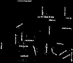
91
92

93
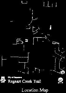
94

95 valid easement for encroachment be created in favor of an Owner or Owners if said encroachment occurred due to the intentional conduct of said Owner or Owners other than adjustments by Declarant in the original construction. In the event a structure is partially or totally destroyed, and then repaired or rebuilt, the Owners of each adjoining Lot agree that minor encroachments over adjoining Lots and Common Area shall be permitted and that there shall be valid easements for the maintenance of said encroachments so long as they shall exist. In the event that an error in engineering, design or construction results in an encroachment of a building into the Common Area, or into or onto an adjoining Lot, or into a required setback area, a correcting modification may ( at the discretion of Declarant) be made in the subdivision map. Said modification shall be in the form of a certificate of correction and shall be executed by Declarant ( so long as Declarant is the sole owner of the Project) and by Declarant' s engineer and by the city engineer. If the correction occurs after title to the Common Area has been conveyed to the Association, the Association shall also execute the certificate of correction. The Board of Directors may, by vote or written approval of a majority of the directors, authorize the execution of the certificate of correction. 2.9 Party Walls and Common Roof Systems: A. General Rules of Law to Apply: Each wall, footing or foundation and/or common roof system that is built as part of the original construction of a residence, is located on the boundary line with an adjacent Lot and either is used in common with the residence on the adjacent Lot or abuts against a similar wall, footing or foundation and/or common roof system on the adjacent Lot shall constitute a " party wall." To the extent not inconsistent with the provisions of this section 2. 9, the general rules of law regarding party walls and liability for property damage due to negligence or willful acts or omissions shall apply thereto. B. Sharing of Repair and Maintenance: The cost of reasonable repair and maintenance of a party wall shall be shared by the Owners who make use of the party wall in proportion to such use. C. Destruction by Fire or Other Casualty: If a party wall is destroyed or damaged by fire or other casualty, any Owner who has used the party wall may restore it, and if the other Owners thereafter make use of the party wall, they shall contribute to the cost of restoration thereof in proportion to such use; provided, however, that the Owner or Owners whose negligent act or omission proximately caused the damage not covered by insurance. DRAFT or destruction, shall bear the full cost of restoration that is D. Weatherproofing: Notwithstanding any other provisions Owner who by his negligent or willful act causes the party wall to be exposed bear the whole cost offurnishing the necessary protection against such elements. of this Article, an to the elements shall E. Right to Contribution Runs with Land: The right of any Owner to contribution from any other Owner under this section 2. 9 shall be appurtenant to the land and shall pass to such Owner' s successors in title. F. Arbitration: In the event of any dispute arising concerning a party wall, or concerning the provisions of this section, upon written request of one ( 1) Owner(s), the matter shall be submitted first to the Board for mediation, and thereafter, if the dispute remains unresolved, to binding arbitration within sixty ( 60) days pursuant to the rules of Judicial Arbitration and Mediation Services (" JAMS"), or any successor thereto, or to any other generally Owner addressed to the other 05/ 16/ 02 T:IWPWIN60lPROJECTSICAMPODELIOEC 6-
96 recognized system of alternative dispute resolution, and judgment may be entered thereon in any court having jurisdiction Maintenance Easement: An easement over each Lot is reserved by Declarant, and is hereby granted to the Association, for the purpose of entering upon the Project to perform such maintenance, if any, as the Association may do in accordance with the provisions of section S. la of this Declaration Drainage Easements: An easement over and under each Lot as the servient tenement is reserved in favor of each other Lot as the dominant tenement for the purpose of allowing the Association' s agents to enter the Lot to maintain that portion of an in-tract storm drainage system located thereon. No Owner or occupant shall commit any act that would interfere with the operation of any drainage system ( including drainage swales) installed on the Owner' s Lot, each Owner shall maintain the system free of debris and other obstacles at all times. Reciprocal appurtenant easements between each Lot and the Common Area and between adjoining Lots are reserved for the flow of surface water Pedestrian Pathway Easement: Declarant, as required by City, has constructed a pedestrian pathway that passes through the Project, from Rodrigues Avenue to the Regnart Creek walkway. The pathway may be used during daylight hours ( only) by the public to walk between Rodriques Avenue and the Regnart Creek walkway. The pathway is designated " 10' Pedestrian Pathway Easement" on the Map Other Easements: The Common Area and each Lot are subject to all easements, dedications, and rights of way granted or reserved in, on, over and under the Project as shown on the Map Rights of Entry and Use: The Lots and Common Area ( including Restricted Common Area) shall be subject to the following rights of entry and use: A. The right of the Association' s agents to enter any Lot to cure any violation of this Declaration or the Bylaws, provided that the Owner has received notice and a hearing as required by the Bylaws ( except in the case of an emergency) and the Owner has failed to cure the violation or take steps necessary to cure the violation within thirty ( 30) days after the finding of a violation by the Association; improvements or property DRAFT B. The access rights of the Association to maintain, repair or replace located in the Common Area as described in section 5. 2E; C. The easements described in this Article II; as described in section 7. 19; D. The right of the Association' s agents to enter any Lot to perform maintenance section E. The rights of the Declarant during the construction period as described in Partition of Common Area: There shall be no subdivision or partition Common Area, nor shall any Owner seek any partition or subdivision thereof. of the 05/ 16/ 02 T:\WPWIN60\ PROJECTS\CAMPODEL\DEC 7-
97 APPENDIX C PUBLIC OUTREACH MEMOS & COMMENTS Public Outreach Comment Summary Walkshop Memo and Comments Public Outreach Meeting #1 Memo and Comments Public Outreach Meeting #2 Memo and Comments DRAFT HMH C
98 THIS PAGE INTENTIONALLY LEFT BLANK DRAFT REGNART CREEK TRAIL
99 Summary of Public Comments Category Comments Response Aesthetics Fences behind homes will not be visually unappealing. Fence alternatives presented in the study provide customization and aesthetically pleasing options. Aesthetics Trail will not have enough vegetation to be visually appealing. No vegetation will be added along the trail. Existing vegetation will be maintained and upkept to be visually appealing. Aesthetics Concern about trash on trail. Trail maintenance, including trach clean-up, is the responsibility of the City. Aesthetics Concerns about vandalism. Addressing vandalism along the trail will be the responsibility of the City. Cost Cost Maintenance Total capital cost of trail project is not worth the expense (not including maintenance) Concern about how the project will be funded. Cost of routine trail maintenance is not worth the expense City Council's decision to fund the construction and maintenance of the trail will consider how the project addresses the City's goal of improving multi-modal access and safety. Funding sources for the construction and maintenance of the trail will be identified if the trail is approved. City Council's decision to fund the construction and maintenance of the trail will consider how the project addresses the City's goal of improving multi-modal access and safety. As a City-owned facility, the trail will be maintained by the City. The SCVWD is responsible for creek maintenance. Fencing and security measures will be implemented to mitigate trespassing. Fencing and security measures will be implemented to mitigate trespassing. Fencing alternatives presented in the study are capable of providing noise abatement. Maintenance Concern about who is going to maintain the trail. Privacy Concern about encroachment onto private property. Privacy Concern about privacy for neighboring residents. Privacy Concern about noise for neighboring residents. Privacy Concern about dogs barking. Fencing alternatives presented in the study are capable of providing noise abatement. Safety Concerns about lack of entry and exit along Access points along the trail will be provided for emergency vehicle the trail for emergency vehicle access and ingress and egress. patrol. DRAFT Safety Concern about trail users getting hit by cars at road crossings. Treatments that provide safe crossings for bicyclists and pedestrians will be implemented. Safety Access points along the trail will be provided for emergency vehicle ingress and egress. Safety Concern about trail users being injured by ditches. Grading and the implementation of the selected trail surface will eliminate ditches. Safety Concerns about wildlife being a nuisance or Wildlife mitigation will not be provided on the trail. attacking trail users. Safety Pathway poses risk of property theft for bicycles and pedestrians. Recent reports from trails in the San Jose, Saratoga, Cupertino demonstrate that this is not an issue. Security measures through sheriff and patrolling will be implemented to deter suspicious activity. Safety Concerns about users falling into the creek. Railing at the top of the creek bank will be implemented to mitigate trail users from falling into the creek. Safety Concerns about trail users being assaulted or Recent reports from trails in the San Jose, Saratoga, Cupertino robbed. demonstrate that this is not an issue. Security measures through sheriff and patrolling will be implemented to deter suspicious activity.
100 Category Comments Response Safety Safety Concerns about neighboring residents being burglarized. Pathway will improve bicycle and pedestrian safety by offering space free of cars to ride and walk. Recent reports from trails near residences in the San Jose, Saratoga, Cupertino demonstrate that this is not an issue. Security measures through sheriff and patrolling will be implemented to deter suspicious activity. The Regnart Creek Trail meets the vision and goals of the City's Bike Plan and Pedestrian Plan. Safety Activity on trail will discourage crime. Crime is unlikely to occur on a facility that is frequently used by bicyclists and pedestrians. Safety Pathway will improve accessibility to schools. The trail increases connectivity between residences and schools. Safety Concerns about driver speeds along S Blaney Avenue and E Estates Drive Traffic calming measures will be implanted to reduce drive speeds and increase bicycle and pedestrian safety. Safety Concerns about trail users crossing streets without caution. Warning signage and chicanes on the trail will be implemented to slow down trail users approaching a roadway crossing. Safety Pathway will improve accessibility to library The trail increases connectivity between residences, schools, and the Cupertino Library. Safety Concerns about trail exposing backyards of residents. Existing fences that are dilapidated and don t have adequate visual screening will be replaced. Traffic Pathway will exacerbate traffic congestion for The trail offers the opportunity to bike/walk as opposed to driving, drivers. resulting in less cars on the road. Driver commute times added by slowing down or stopping at roadway crossings are not significant. Wildlife Trail will attract wildlife, which is beneficial. The trail does not intend to disturb existing the wildlife that depend on the creek as work will not be done within the creek. Wildlife Pathway will disturb wildlife. The trail does not intend to disturb existing the wildlife that depend on the creek as work will not be done within the creek. DRAFT
101 84 W Santa Clara Street, Suite 830 San José, CA (408) MEMORANDUM To: Jennifer Chu and David Stillman, City of Cupertino From: Lola Torney and Jeff Knowles, Alta Planning + Design CC: Jon Cacciotti, HMH Date: November 28, 2017 Re: Regnart Creek Trail Walkshop Summary Background On November 18, 2017, the City of Cupertino held a walking workshop, or Walkshop along a segment of the Regnart Creek access road from Pacifica Drive to Wilson Park (past Blaney Avenue). This segment is identified as part of the Cupertino Loop Trail system in the 2016 Bicycle Transportation Plan. Event Outreach The City of Cupertino mailed 104 postcards to residents who live adjacent to the trail extents. In addition, the Walkshop was advertised on the City s website, The Cupertino Scene, social media (Next Door, Facebook, Instagram), flyer distributions at the Fall Bike Festival, flyer postings at the Library and City Hall, Safe Routes to School monthly newsletter, an to those who signed up for the Bicycle Transportation Plan e-notifications, and the TV monitors with rotating information at many City facilities. The School District and Walk-Bike Cupertino also promoted the event through their media outlets. Copies of the flyer and postcards are attached at the end of this memo. Event Details DRAFT The event was divided into a morning session (10:30am to 12pm) and an afternoon session (1:00pm to 2:30pm). Fifty-seven people signed into the event. All attendees were escorted on tours led by City and consultant staff. Attendees were given the opportunity to walk the entire segment open to the public. Attendees were invited to submit comments about the potential trail on comment cards. Thirty-six comment cards were submitted and attached at the end of this memo. City of Cupertino 1


102 City of Cupertino Regnart Creek Trail Feasibility Study DRAFT 2 City of Cupertino


103 Regnart Creek Trail Walkshop Summary DRAFT City of Cupertino 3
104 City of Cupertino Regnart Creek Trail Feasibility Study Public Feedback The feedback received from the comment cards fell into several themes. Many cards touched on multiple themes. The themes were: Concerns about security and privacy for those who live adjacent to the potential trail Concerns about aesthetics of the fence or wall that would separate the potential trail from homes Concerns about potential trail crossing at Blaney Avenue Concerns about cost to implement the trail Concerns about activities trail users may partake in Support for the project as it provides an off-street option for bicyclists and pedestrians Support for the project as it will help reduce traffic concerns (gets people out of their cars) Support for project as it provides more green space for families and community members to enjoy Questions regarding liability Identifying preferred potential trail features including: o Decomposed granite o Bollards with lights o Dog cleanup bag kiosks o Paved trail with unpaved shoulders DRAFT 4 City of Cupertino


105 Regnart Creek Trail Walkshop Summary DRAFT Figure 1: Walkshop postcard City of Cupertino 5

106 City of Cupertino Regnart Creek Trail Feasibility Study DRAFT Figure 2: Walkshop flyer 6 City of Cupertino
107 FT
108 FT
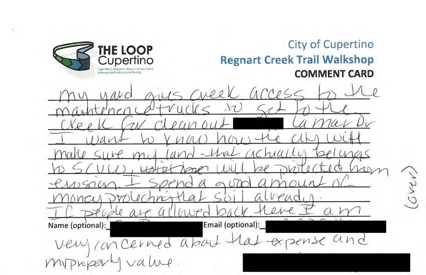
109 FT
110 FT
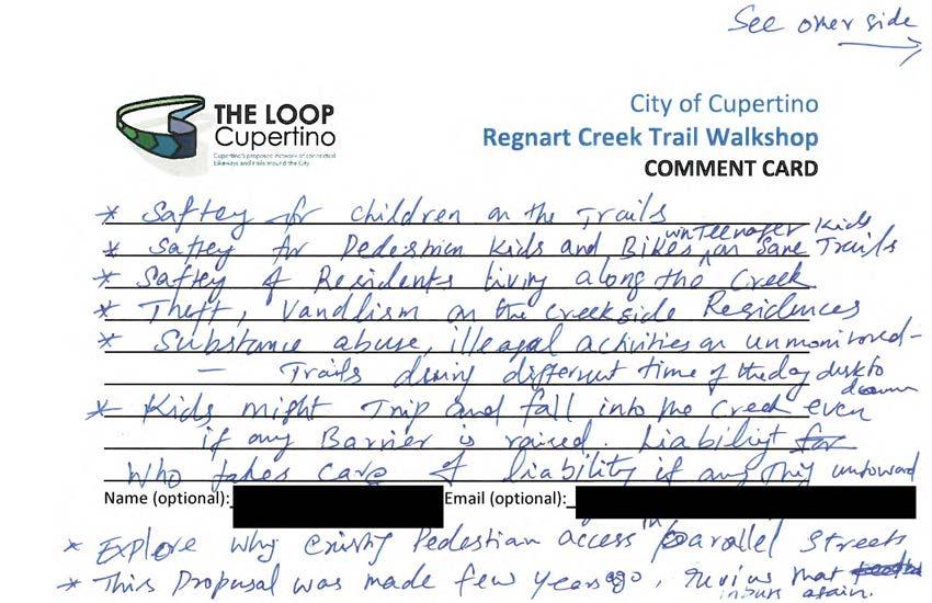
111 FT
112 FT
113 FT
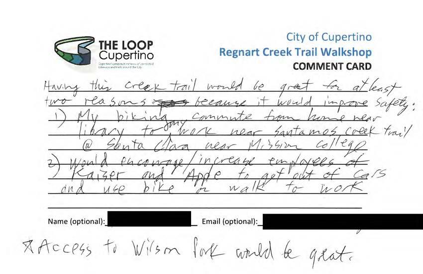
114 FT
115 FT
116 FT
117 FT
118 FT
119 FT
120 FT
121 FT
122 FT
123 FT
124 FT
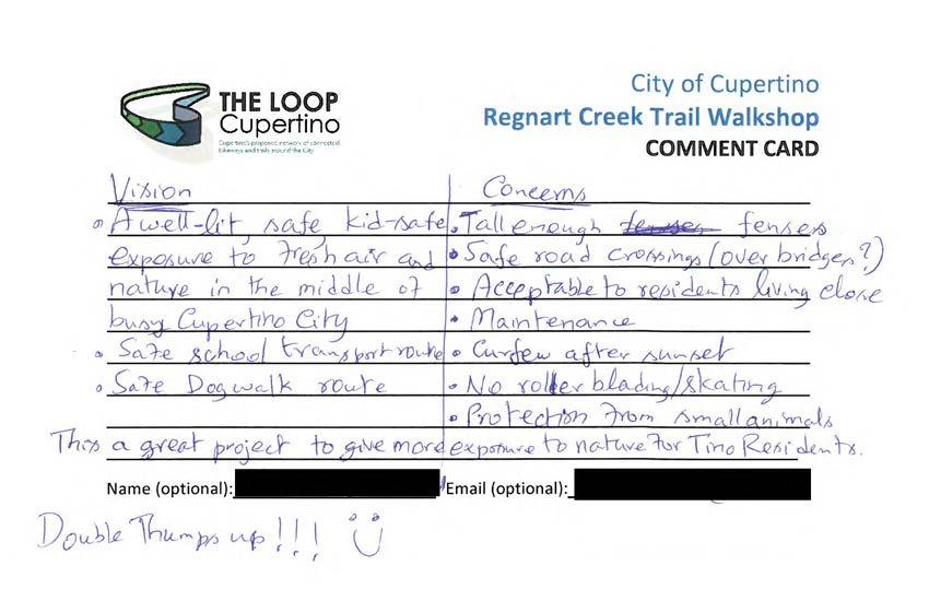
125 FT
126 FT
127 FT
128 FT
129 FT
130 FT
131 FT
132 FT
133 FT
134 FT
135 FT
136 FT
137 FT
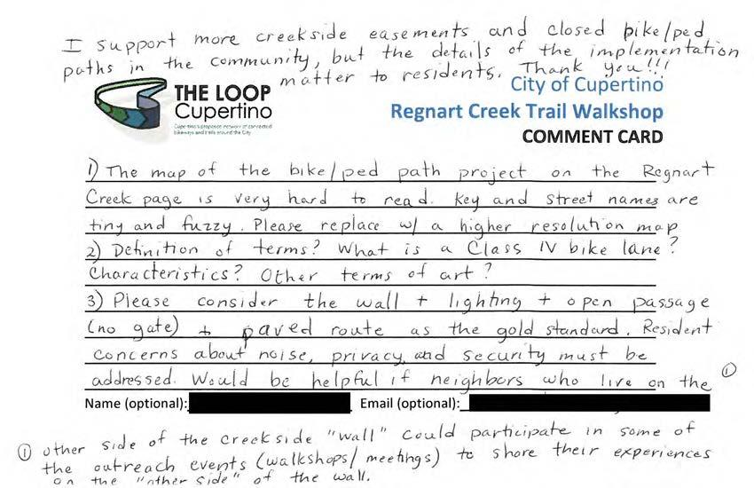
138 FT
139 FT
140 FT
141 FT
142 FT
143 FT
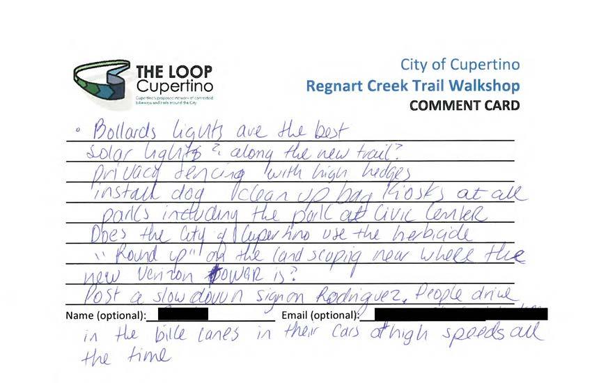
144 FT
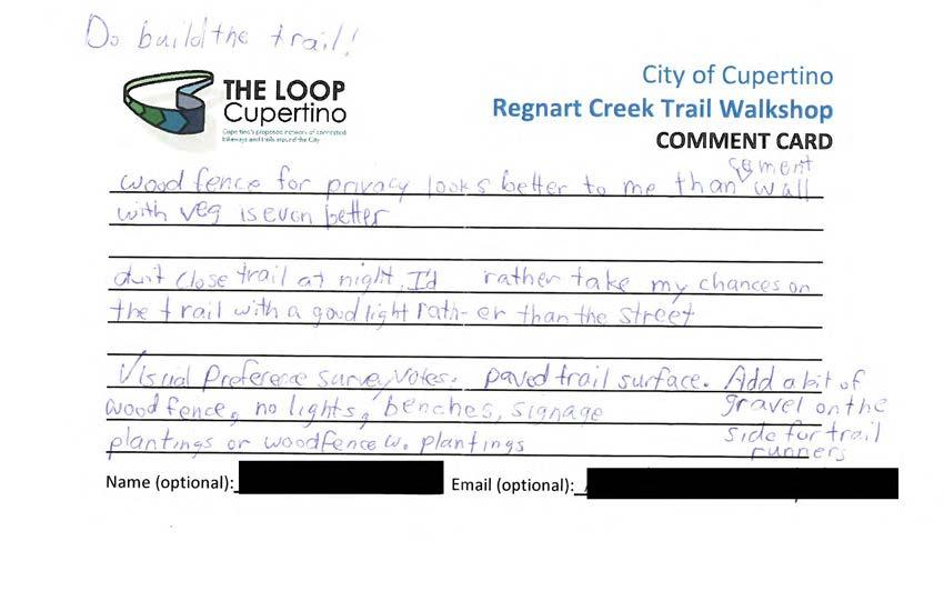
145 FT
146 84 W Santa Clara Street, Suite 830 San José, CA (408) MEMORANDUM To: Jennifer Chu and David Stillman, City of Cupertino From: Lola Torney and Jeff Knowles, Alta Planning + Design CC: Jon Cacciotti, HMH Date: January 25, 2018 Re: Regnart Creek Trail Public Workshop Summary Background On January 22, 2018, the City of Cupertino held a public workshop regarding the Regnart Creek Trail Feasibility Study, which will determine feasibility of converting the access road adjacent to Regnart Creek between Pacifica Drive and Wilson Park (past Blaney Avenue) to a shared use path/trail. This segment is identified as part of the Cupertino Loop Trail system in the 2016 Bicycle Transportation Plan. Regnart Creek and access road is owned by the Santa Clara Valley Water District. The feasibility study will identify technical constraints, gather public feedback, and develop design concepts for alternatives to the trail design. Event Outreach There was extensive outreach done to promote the meeting. The City of Cupertino mailed 587 postcards to residents who live within 300 feet of a potential trailhead Door hangers were distributed to residents directly adjacent to the trail extents The workshop was advertised on: o The City s website, radio, and TV channel o Social media (Next Door, Facebook, Twitter) o s to subscribers of the City s Bicycle Transportation Plan e-notifications o s to the Cupertino Block Leaders in the neighboring area o Flyer postings around Cupertino Civic Center SR2S group advertised the meeting through: o A mention in the monthly newsletter o An agenda item at the January 16, 2018 SR2S Working Group o s to the surrounding schools (Eaton, Faria, Collins, Lawson, and Cupertino High) The Cupertino Courier advertised the event Copies of the flyer and postcards are attached at the end of this memo. Event Details DRAFT The event was held in the Community Hall in the Cupertino Civic Center from 6:30 8:00pm. The meeting was open house style with boards placed on easels around the hall and two large maps of project extents placed on City of Cupertino 1

 indicated yes by placing sticker dots in the thumbs-up row, fifty (50) indicated no, and three (3) indicated not sure/need more information.")
147 City of Cupertino Regnart Creek Trail Feasibility Study tables on either side of the room. A slideshow of photos of the project area were projected during the event. David Stillman, with the City of Cupertino, and Jon Cacciotti, with HMH Engineers, briefly spoke to introduce the project and then meeting participants were able to engage in conversations with City and consultant staff at stations and boards around the room. One board asked attendees for direct feedback, asking, If a trail were built along Regnart Creek, would you or your family use it? Forty-five (45) indicated yes by placing sticker dots in the thumbs-up row, fifty (50) indicated no, and three (3) indicated not sure/need more information. Photos of the boards and maps are shown at the end of this memo. Eighty-seven (87) people signed into the event. Attendees were invited to submit comments about the potential trail on comment cards. Sixty-seven (67) comment cards were submitted and attached at the end of this memo. DRAFT 2 City of Cupertino


148 Regnart Creek Trail Walkshop Summary DRAFT City of Cupertino 3

149 City of Cupertino Regnart Creek Trail Feasibility Study Public Feedback The feedback received from the comment cards fell into several themes. Many cards touched on multiple themes. The themes were: Concerns about security and privacy for those who live adjacent to the potential trail Concerns about aesthetics of the fence or wall that would separate the potential trail from homes Concerns about potential trail crossing at Blaney Avenue o Suggestions for the crossing included a raised crosswalk, an activated beacon, and a crossing guard during school commute times Concerns about activities trail users may partake in Concerns about available right-of-way near and potential access to De Palma Lane Support for the project as it provides an off-street option for bicyclists and pedestrians Support for the project as it will help reduce traffic concerns (gets people out of their cars) Support for project as it provides more green space for families and community members to enjoy Support for the project as it will provide a more direct route to the Library Support for the project as it will provide access to several schools Questions regarding liability Questions about what times the trail would be open Questions regarding cost to implement project Identifying preferred potential trail features including: o Fencing between the trail and the creek o Asphalt pavement (as opposed to leaving it natural or using gravel) o Benches o Bicycle fix-it stations DRAFT Comment cards, s, and letters received as part of this workshop are attached at the end of this memo. 4 City of Cupertino


150 Regnart Creek Trail Walkshop Summary DRAFT Figure 1: Workshop postcard City of Cupertino 5

151 City of Cupertino Regnart Creek Trail Feasibility Study DRAFT Figure 2: Workshop flyer 6 City of Cupertino

152 Regnart Creek Trail Walkshop Summary DRAFT Figure 3: Workshop door hanger City of Cupertino 7

153 City of Cupertino Regnart Creek Trail Feasibility Study DRAFT Figure 4: Workshop "vote" board 8 City of Cupertino


154 Regnart Creek Trail Walkshop Summary DRAFT Figure 5: Closeups on the vote board City of Cupertino 9

: Closeups on comments on")
155 City of Cupertino Regnart Creek Trail Feasibility Study Figure 6: Comments on aerial maps DRAFT 10 City of Cupertino Figure 7 (and following images): Closeups on comments on aerial maps


156 Regnart Creek Trail Walkshop Summary DRAFT City of Cupertino 11


157 City of Cupertino Regnart Creek Trail Feasibility Study DRAFT 12 City of Cupertino

158 Regnart Creek Trail Walkshop Summary DRAFT City of Cupertino 13

159 City of Cupertino Regnart Creek Trail Feasibility Study DRAFT 14 City of Cupertino

160 Regnart Creek Trail Walkshop Summary DRAFT City of Cupertino 15
161 City of Cupertino Regnart Creek Trail Feasibility Study Sent: Tuesday, January 23, :17 PM To: Jennifer Chu David Stillman Subject: Regnart Creek Trail feedback Jennifer & David, It was great seeing you again last night. Thank you for conducting the successful November walkshop as well as last night's feedback meeting. Here are my thoughts DRAFT as someone who bikes around Cupertino a lot: 1) The Regnart Creek Trail would be awesome! I visit Cupertino City Hall and the library frequently. I also travel to both Wilson park and Creekside park for soccer. Getting all these facilities connected by a beautiful trail would be magnificent! This is a great step forward for Cupertino to create safer routes for kids and the elderly to its parks, city center and schools. It would definitely be a gem of a trail. 2) It is amazing how many who oppose trails initially flip around and become huge supporters once the trail is completed and they realize their fears did not materialize but the benefits did. This flip has happened a number of times with the Stevens Creek trail and seems to have been the case with many trails in the US. That things turn out better than the opposition thought was also reaffirmed by a recent Headwaters Property Value study: "Research also shows that those who opposed a trail prior to construction generally find a trail to be a much better neighbor than they anticipated." See Please also check out our own local documentation of this in a short neighborhood feedback video that the Friends of Stevens Creek Trail did a couple of years ago after a new segment of trail opened up near Sleeper Ave: Thanks! Sincerely, [name omitted for privacy] 16 City of Cupertino
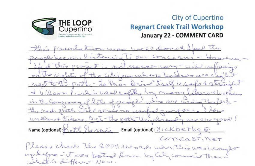
162
163
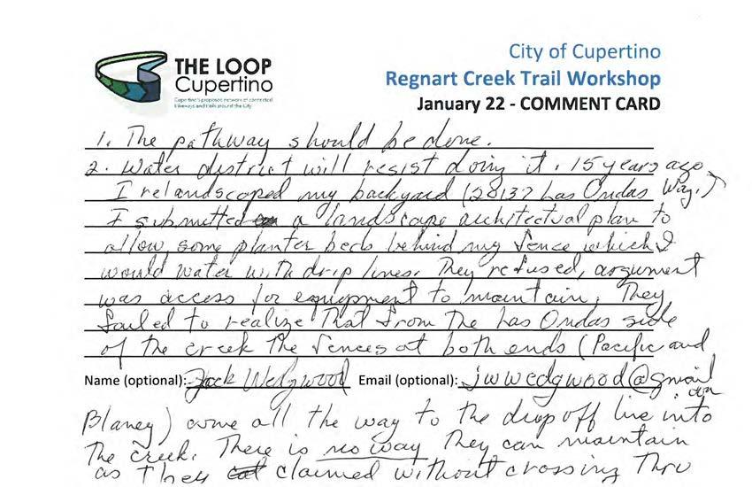
164
165
166
167
168
169
170
171
172
173
174
175
176
177
178
179
180
181
182
183
184
185
186
187
188
189
190
191
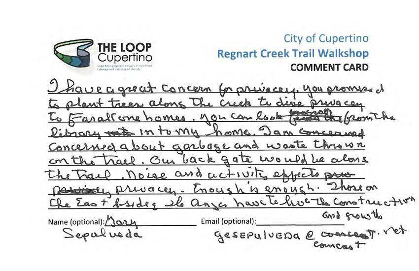
192 RAFT
193
194
195
196
197 FT
198 FT
199
200
201
202
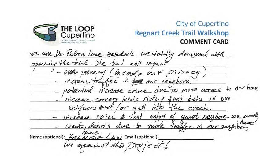
203
204
205
206
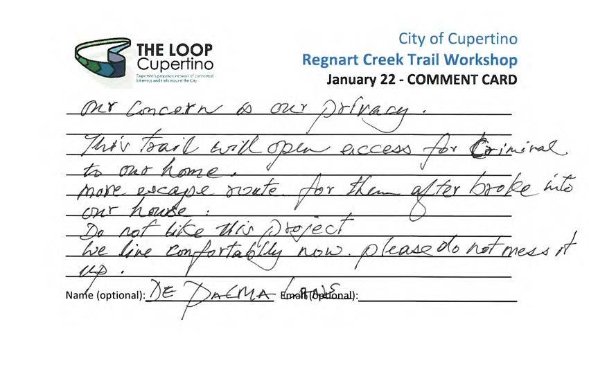
207
208
209
210
211
212
213
214
215
216
217
218
219
220
221
222
223
224
225
226
227
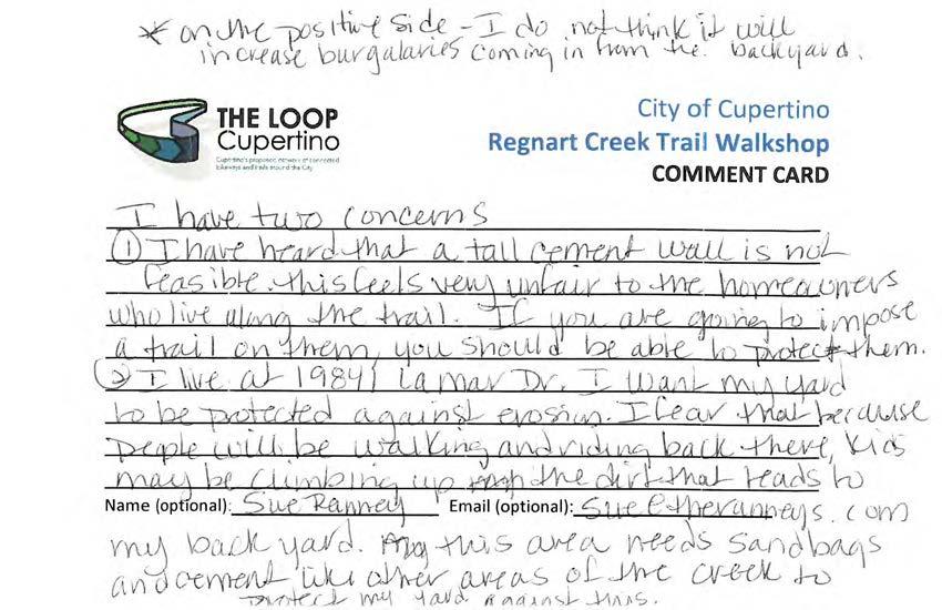
228
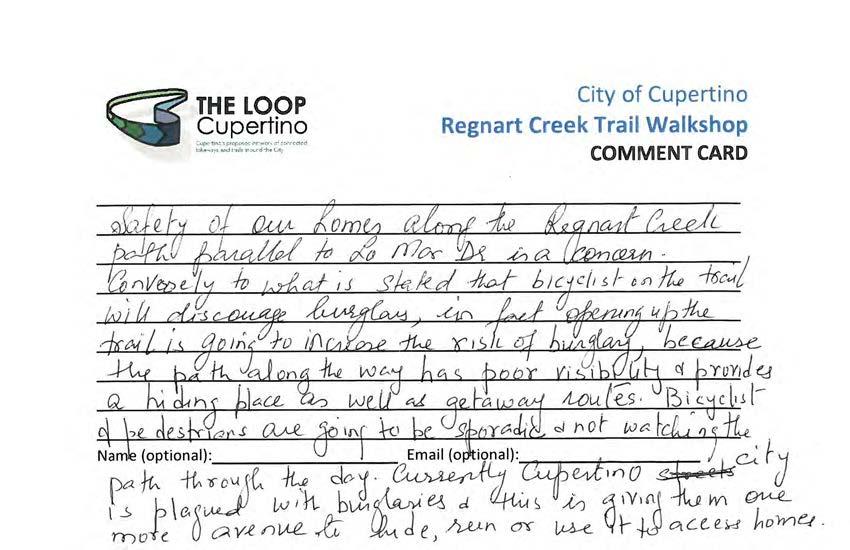
229 RAFT
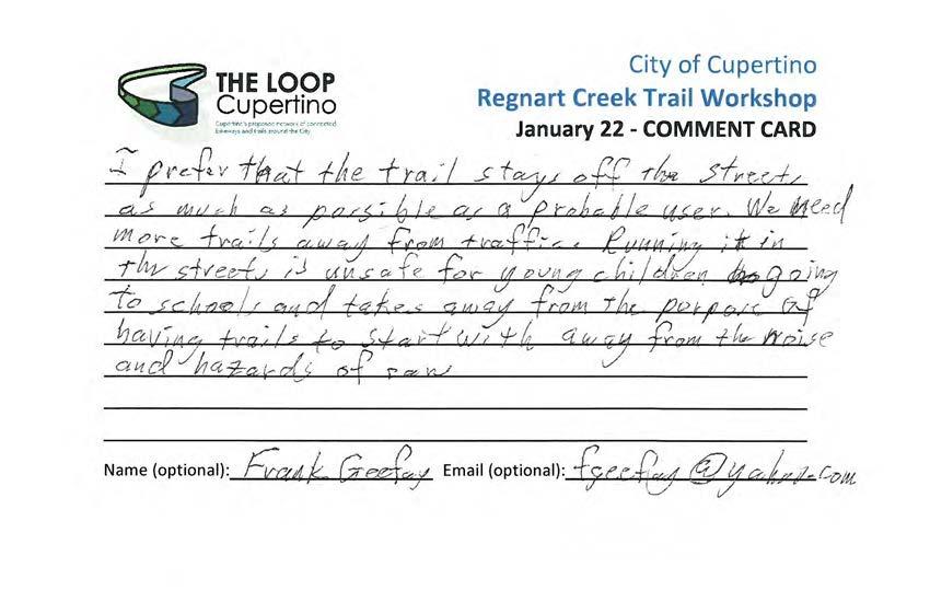
230
231
232
233
234
235
236 84 W Santa Clara Street, Suite 830 San José, CA (408) MEMORANDUM To: Jennifer Chu and David Stillman, City of Cupertino From: Lola Torney and Jeff Knowles, Alta Planning + Design CC: Jon Cacciotti, HMH Date: April 27, 2018 Re: Regnart Creek Trail Study Public Workshop Summary Background On April 23, 2018, the City of Cupertino held a public workshop regarding the Regnart Creek Trail Study, which will determine the feasibility of converting the utility access road adjacent to Regnart Creek between Pacifica Drive and Wilson Park (past Blaney Avenue) to a shared use path/trail. This segment is identified as part of the Cupertino Loop Trail system in the 2016 Bicycle Transportation Plan. Regnart Creek and the adjoining utility access road is owned by the Santa Clara Valley Water District. The feasibility study will identify technical constraints, gather public input, and develop design concepts and cost estimates. Event Outreach The City promoted the workshop using the following techniques: The City of Cupertino mailed 587 postcards to residents who live within 300 feet of a potential trailhead The City of Cupertino hung 170 door hangers to residents directly adjacent to the trail extents The workshop was advertised on: o The City s website, radio, and TV channel o Social media (Next Door, Facebook, Twitter) o s to subscribers of the City s Bicycle Transportation Plan e-notifications o s to the Cupertino Block Leaders in the neighboring area o s to participants from prior outreach events o Flyer postings around Cupertino Civic Center Cupertino Safe Routes to Schools (SR2S) group advertised the meeting through: o A mention to Cupertino Unified School District (CUSD) staff in a March 26, 2018 meeting o A mention at the March 13 and April 11, 2018 SR2S Working Group Meetings with flyer distribution to attendees o s to the surrounding schools (Eaton, Faria, Collins, Lawson, and Cupertino High) The Cupertino Courier advertised the event Copies of the flyer and postcards are attached at the end of this memo. DRAFT City of Cupertino 1


237 City of Cupertino Regnart Creek Trail Feasibility Study Event Details The event was held in the Community Hall in the Cupertino Civic Center from 6:30 8:00 p.m. The meeting was open house style with boards placed on easels around the hall. A slideshow of photos of the project area were projected during the event. Cupertino Transportation Manager David Stillman and Jon Cacciotti, a consultant with HMH Engineers, welcomed participants and shared an update on the project. Captain Rich Urena with the Santa Clara County Sheriff s Office then provided a brief summary of safety calls for the Saratoga Creek Trail, a Cupertino trail with similar conditions to the Regnart Creek. Captain Urena noted that in the past 17 years, only five calls have been made to the trail, four of which were noise-related, with the fifth involving a homeless person. Meeting participants were then able to engage in conversations with City and consultant staff at stations and boards around the room that illustrated design ideas for road crossings, trailheads and amenities, concepts for addressing privacy and security on the proposed trail. The boards and maps are shown at the end of this memo. Sixty-five (65) people signed into the event. Attendees were invited to submit comments about the potential trail on comment cards. Fifty-nine (59) comment cards were submitted and attached at the end of this memo. Attendees were also asked to fill out a trail design preference worksheet with potential options for the various elements of trail design including fencing, privacy screens, trail surface, roadway crossing options, and security measures. Twenty (20) worksheets were turned in with preferences indicated. An additional 10 worksheets were turned in, but did not provide preferences. DRAFT 2 City of Cupertino


238 Regnart Creek Trail Workshop Summary Public Feedback DRAFT The feedback received from the comment cards fell into the same themes heard at previous events. Many cards touched on multiple themes. The themes were: Concerns about security and privacy for those who live adjacent to the potential trail Concerns about aesthetics of the fence or wall that would separate the potential trail from homes Concerns about potential trail crossing at Blaney Avenue Concerns about activities trail users may partake in Support for the project as it provides an off-street option for bicyclists and pedestrians Support for the project as potential trail crossings for Blaney Avenue has been addressed through design City of Cupertino 3
239 City of Cupertino Regnart Creek Trail Feasibility Study Support for the project as it will help reduce traffic concerns (gets people out of their cars) Support for project as it provides more green space for families and community members to enjoy Support for the project as it will provide a more direct route to the Library and Wilson Park Support for the project as it will provide access to several schools Questions regarding cost to implement project Questions about lighting for the trail Comment cards, s, and letters received as part of this workshop are attached at the end of this memo. Trail Design Preference Worksheet The most popular design element of each section is listed in the table below. A tally of the trail design preference worksheet including attendees rationale for their decision is included at the end of this memo. Category Winner Image Votes Railing Chain link fence 7 Privacy Screen Fence Extension 10 DRAFT Trail Surface Asphalt Pavement 8 Security Measure Police Patrols 12 4 City of Cupertino

240 Regnart Creek Trail Workshop Summary Category Winner Image Votes Roadway Crossings Flashing Beacon 9 DRAFT City of Cupertino 5

241 City of Cupertino Regnart Creek Trail Feasibility Study DRAFT Figure 1: Workshop postcard 6 City of Cupertino

242 Regnart Creek Trail Workshop Summary DRAFT Figure 2: Workshop door hanger City of Cupertino 7
243 City of Cupertino Regnart Creek Trail Feasibility Study s Received (between February 1 and April 26, 2018) Re: Bike Trail Jennifer, Why have a public meeting it sounds as though you have made up your mind. You appear to have ignored the public response in other public meetings. Why discuss the construction of a trail when you are discussing "conceptual design" for the proposed trail. I live in back of the library and city hall and can expect the noise, activity, violation of my privacy, and the garbage that will come. Look what your library has created. The city promised to plant trees along the back to insure our privacy and they have failed. The library still looks into one of my bedrooms. I am against the trail, DRAFT why come to a meeting to discuss an outcome you have already decided [name omitted for privacy] Re: comment regarding Regnart Creek Trail Hi Jennifer, I received a postcard for the Regnart Creek Trail because I own a home on [omitted for privacy]. I reside near the Blackberry Farm trail. I will be unable to attend the meeting. I have 2 suggestions based on my firsthand experience of the Blackberry Farm trail: 1. Please make sure that the material used for the trail can accept leaf litter and moisture without getting slippery. The trail at Blackberry Farm can get very slippery. So, they have a parks guy with a blower, blow it off. The slippery-when-wet trail surface has had the following negative impacts: a. trail is less safe, b. trail costs more to maintain because the trail guy is out there regularly with a leaf blower, c. the noise from the leaf blower reduces the enjoyment of the trail by trail users, animals, neighboring homeowners (I'm not close enough to the trail to hear the blower there, but I do hear blowers used for other things and they're annoying), and can cause long-term hearing impairment for City employees d. the odor and pollution from the leave blower (the electric one isn't strong enough for certain applications, so a gas-powered one is used), is unpleasant for trail users, animals, puts City employees at risk, increases maintenance cost with non-renewable fuels, and increases greenhouse gasses. 2. Please consider the privacy of local neighbors by eliminating signage/maps for neighborhood access points. This is something that the City of Mountain View has done for many years - I have seen it in their EIRs. I have not seen this common courtesy extended by the City of Cupertino for its residents. If you would make special considerations for neighborhood access points, you might ease the path (I had to include a pun) toward completing this project. Warm Regards, [name omitted for privacy] 8 City of Cupertino
244 Regnart Creek Trail Workshop Summary Re: Bike Safety Dear City Council Members, I am writing to express my fullest support for developing the Regnart Trail and other car-free biking paths in Cupertino. I'm not a serious biker, but I enjoy going out for a ride with my kids, especially now with the weather being so nice. Sometimes we like to bike over to the library, but it can get a little dicey on Blaney and Rodriguez. I don't think I can ever let my kids, who attend Meyerholz (CLIP) bike to school from our home near Sedgwick, because it would involve biking down Bollinger during rush hour. I'd like to share one particular incident that motivated this to you. On Sunday 4/22 -- Earth Day -- my husband was on roller blades and the rest of us-- my son (age 7) and twin girls (age 5) and I were biking back from eating dinner at The Counter off Stevens Creek. It was a beautiful evening. We were heading east on Stevens Creek, waiting on the sidewalk to cross Blaney. The light turned green and we had the walk light so I told my son to start going across without looking behind my left shoulder like I usually do to check for turning cars. My son, who also usually looks, didn't look this time, nor did my husband. Unfortunately there was a car turning right onto Blaney from Stevens Creek, who didn't notice my son in the crosswalk and came literally inches from hitting him. Luckily she was able to slam on the brakes and, after screaming for my son to stop, a collision was very very narrowly avoided. It was very frightening for all involved. Thankfully nothing happened but it was very close. Too close. We'd really love to bike more, but after yesterday's incident, I will have to think twice. So the more we can do to improve bike safety, the better. Thank you. Sincerely, [name omitted for privacy] Re: Regnart Creek Trail proposal: in support DRAFT Dear City Council member(s), I am writing to you in support of the proposed Regnart Creek Trail. We often have family visiting from India. Our old Indian parents do not drive in the USA. They often feel they are in 'house arrest' when they visit Cupertino. We also have young school going daughters. Our kids need a safe way to reach the library. This trail will allow them to go to the library on their own. We support the trail. Sincerely, [name omitted for privacy] Cupertino resident and parent of students in Cupertino school districts Re: Support for Regnart Creek Trail Dear Honorable Cupertino City Council Members, City of Cupertino 9
245 City of Cupertino Regnart Creek Trail Feasibility Study I am a parent of four children who have attended CUSD schools: West Valley, Meyerholz, Cupertino Middle and Homestead High. I have been active in Safe Routes to School (SRTS) at each school for several years. I have worked with SRTS city personnel in San Jose (Meyerholz), Sunnyvale (Cupertino Middle) and Cupertino (Homestead High). I firmly believe it is important to create ways for students to travel safety to and from school. One of the best and most pleasant ways to travel is via a traffic-free trail. I support the Regnart Creek Trail project because it creates a safe pathway for students and community members to travel in Cupertino. I believe parents would be more willing to allow their children to ride bikes to school if there was a safe, traffic-free trail. I have been fortunate enough to have lived near the Stevens Creek Trail in Mountain View, and I now currently live in Sunnyvale near the Highway 85 pedestrian bridge. My children, starting in kindergarten, were able to bike to school. We saved time and enjoyed our surroundings while decreasing traffic and pollution in our school neighborhood. I ve attached my experiences of living near safe bike/pedestrian routes as a testimony to the benefits of having a trail. I hope you consider my comments in your decision making process. Sincerely, [name omitted for privacy] Re: public meeting I received your notification of another meeting regarding opening the creekside for public use as a proposed trail. I am a resident who lives directly behind the City Hall, I am a resident who lives in this home over 30 yrs, and have experienced in the past when it was open to the public, and all was not good. Noise, garbage, camping, kids peeing in the creek, motorcycles, climbing fences, crime issues, broken windows, need I say more. Is the city going to police the area? Is the city going to be sure that it does not become a haven for the homeless? These are important questions to be answered. I am 100% AGAINST THIS PROPOSAL. HOPING GOOD JUDGEMENT WILL BE IN THIS PROPOSAL. Thank you for the opportunity of being able to speak my piece. [name omitted for privacy] Re: Regnart Creek Path Hi Timm, David and Jennifer, As committed to you at the March 21 st meeting of the Bike and Pedestrian Commission, we are attaching a list of the concerns of our neighborhood regarding the potential opening of the Regnart Creek Path. Please forward to Jon Cacciotti of HMH and others as needed. Kindest regards, The Regnart NeighborhoodDRAFT Creek Path 10 City of Cupertino
246 Regnart Creek Trail Workshop Summary Benefits of Living Near a Trail My husband and I bought a new home in 1996 near downtown Mountain View and we were a bit clueless that we lived so close to the Stevens Creek Trail. A trail head opened in our neighborhood shortly after we moved in. Our neighbors would wander down there to check out the creek, but I didn t use the trail regularly until our oldest child started kindergarten. My son was enrolled at Landels Elementary, near the heart of downtown Mountain View. We lived across the train tracks from school, on the north side of Central Expressway. If we did not have access to the Stevens Creek Trail, I would have to drive my child across the tracks to get to school. According to Google Maps, it is a 1.4 mile drive in 7 minutes. However, that does not account for the Cal Train crossing. One time, it took me 15 minutes to get to school because of the trains. The best part about the trail was that my 4 year old son (late birthday!) could ride his bike to school everyday, DRAFT traffic-free! It was a 0.9 mile ride. Google Maps says it s a 5 minute ride, so we had time to watch the trains as we passed over Central Expressway. After school, we had time to check out the creek, find rollie pollies and chase butterflies. As a young mom, I loved have a safe pathway to and from school. My son LOVED riding his bike to school. That would not have happened if he had to cross Central Expressay and the train tracks. When we sold our Mountain View home in 2006, we had several offer letters that expressed their desire to be close to the trail. Again, we had no idea that this was something buyers were looking for and were willing to bid above asking price to get. When we moved to Sunnyvale, we were grateful to find a home close to a pedestrian bridge that crosses over Highway 85. My four children have been fortunate to be able to ride their bikes to school (West Valley, Cupertino Middle and Homestead High.) They get to school faster than if I had to drive them to school. They are more aware of their environment and they gain confidence and independence. They prefer to ride their bikes than carpool! I hope that the Regnart Trail will be built so that students and community members will have a safe, traffic free option to bike and walk in Cupertino. Sincerely, [name omitted for privacy] City of Cupertino 11
247 Regnart Creek Trail Site Elements Please place an X next to your preferred design element and explain why. Refer to the Regnart Creek Trail Site Elements board for pros and cons of each. Railing Chain Link Fence: 7 Split Rail Fence (wood): 4 Split Rail Fence (steel): 6 None: 2 Why? Chain link fence is less expensive and easy to place and maintain Chain link fence is cost effective Chain link fence is cheaper, I assume, but more sturdy than the one in the photos. Like the one on the Creekside Park segment Chain link fence is a low cost alternative (we have now at Creekside), but small split rail at Blaney crossing Chain link fence is probably the most cost effective Chain link fence is cost effective and relatively impervious Wooden split rail fence is more attractive. Doesn t catch bags/trash/weeds as chain link does Wooden split rail fence is aesthetically pleasing Wooden split rail fence fits in with environment, easy to build Steel split rail fence looks like and is less maintenance than wood Steel split rail fence looks the best Steel split rail fence is nicer looking will last forever The two split rail fences were chosen for aesthetics, but none would be suitable. Not sure it s entirely necessary None as there is no privacy, disrupts habitat duck crossing, double fence. Different settings require different fencing. Hard to generalize for all areas of trail No preference. Chain link fence was better opportunity for green cover. Consider coasted chain link fence DRAFT


248 Privacy Screen Fence Extension: 10 Metal Panel Screen: 4 Acrylite Screen: 1 Sound Wall: 8 Replace Wood Fence: 2 None of these: 2 Why? Fence extensions require the least amount of maintenance Fence extensions are in line with residential fencing Fence extension are simple Try to use as many existing fences as possible. Don t forget to provide some gates Taller fences would provide more screening and abate privacy and some security concerns Metal panel looks nice Gets you to look at the metal panel instead of the neighbor s house Metal panel screens gives a chance for artists to contribute, no maintenance, looks great, natural Sound wall looks nice Sound wall provides maximum security Sound walls can be painted with anti-graffiti paint, blocks noise, and better privacy All are fine If a fence already exists, another on top of it seems unnecessary Replace the wood fence to maximize the width and reduce cost Fence is best for being uniform while adapting to different elevation and alignment. Consistency is important without being too trendy None of these as they block views, are ugly, block sunlight for yards, plastic scratches, inappropriate for front yards not for Lazano Lane/De Palma Lane For resident s back fences, give them a chance to give an opinion and choice if they want a gate. Go with the majority I defer to people living along the trail. Ease of low cost maintenance is important Privacy is important for neighboring residents! DRAFT


249 Trail Surface Decomposed Granite: 5 Asphalt Pavement: 8 Pervious Pavement: 7 None: 1 Why? Decomposed granite requires less time to place and is more natural I like the Saratoga RR trail with decomposed granite. It s pervious and seems to do well with rain and weather Decomposed granite is natural Asphalt pavement is useful at all seasons Asphalt pavement is cheap and easiest to ride on Asphalt pavement is easier to maintain Asphalt pavement is better in rainy weather Asphalt pavement is a softer surface, but more expensive. Same as Stevens Creek Trail in Sunnyvale Asphalt is quite long-lasting and looks neat and nice Pervious pavement because of cost for maintenance. It is not maintained now by water district Pervious pavement because maintenance to water permeable best trade-off Pervious pavement seems the best of both worlds pervious, but also solid for biking and walking Pervious pavement is expensive but much better for managing runoff. Decomposed granite is too hard for wheelchairs and assisted walking Asphalt and pervious pavements are clean, neat, and great for bikes and walkers Decomposed granite and pervious pavement both drain water, more natural. The decomposed granite would also promote a slower pace for cycles Whatever bicyclists and joggers prefer Security Measure DRAFT Security Camera: 8 Emergency Push Buttons: 6 Police Patrols: 12 None: 1


250 Why? Security cameras provide peace of mind for neighbors Security cameras can catch graffiti offenders Occasional only. Generally nothing needed, but emergency buttons would be nice Police patrols are cost effective The police already have some bicycle patrols; hopefully extending the patrols would be easy All of the above if possible! I think people should be more scared getting in their cars every day than of having a trail behind their house All of the above keep it safe Lots of security and privacy for existing residents. De Palma Lane will need bollards to prevent vehicle traffic. Not enough space for fire trucks to turn All if it s not too expensive All are good ideas Patrols combined with emergency push buttons Make the local residents feel safe Don t see any real security issue with this trail Roadway Crossings Bulbout: 4 High-Visibility Crosswalk: 8 Raised Crosswalk: 7 DRAFT Median Island: 6 Pedestrian Signal: 5 Flashing Beacon: 9 None: 0 Why? Median island is best for bike safety kids can judge traffic in one direction only Any safety measure is good. Flashing beacons are very visible as a driver. You can see them well before the pedestrians and bikes
251 All are fine solutions. Perhaps beacon as it is cheapest and most visible Best to stop flow Blaney will need all of these. Traffic already congested with trips to Collins Elementary. Will increase traffic when everyone is already in a hurry High visibility crosswalk, raised crosswalk, and flashing beacon to slow traffic and make motorists aware Raised crosswalk at E Estates Drive crossing Alternative 2 S Blaney Avenue On Blaney, pedestrian signal ensures they ll stop (only when pedestrians are there) Increase safety at crossings A well marked crossing is fine Don t like raised crossing. Driving over is issue Visibility is the most important component of pedestrian safety Are there any other design solutions not listed you would like to see along the potential trail? Benches Doggie walk bags Trash receptacles Interpretive signage if there is anything interesting Dotted-dash lines to divide directions to help keep order. Trail etiquette reminder signs Bikes yield to peds Shade A minimal fence between sidewalk and street at trail entrances on Blaney so kids can t bop straight into the street Have access to future parking lot Split rail fencing at crossings Split rail at crossings (parallel to road crossings) Lanes marked to encourage bikes and walkers to stay out of the way of each other Pull outs with benches Lights illuminating trail heads and intersections Some trees/tall bushes for foliage screening may make residents less concerned and provide better experience for people on the trail DRAFT
252 From: Concerned Cupertino residents opposing Regnart Creek Trail Subject: Negatives to be Addressed and Mitigated Cumulatively Considerable issues for the Proposed Regnart Creek Trail Summary Fundamental rights of the citizens of our neighborhood will be violated. These universal rights are safety, security and privacy. A basic question that should be asked before each project is undertaken is Will the neighborhood want it? The consensus answer in our case is a firm no. Retrofit trails in residential neighborhoods are not soundly conceived. Regnart Creek is a flood control culvert and should be left as such. In addition, Regnart Creek is not visible to the public and the project should be cancelled immediately for the safety protection of the overall community. Safety Safety of the neighborhood will be compromised by all the reasons we have stated below. It is important to reemphasis the risks to the homeowners on Lozano Lane and DePalma Lane as the front of their homes are only feet away the existing path. To expand the trail access along Regnart Creek will put these properties at a higher safety risk caused by increase in traffic flow from pedestrians and bikers, many from outside the immediate neighborhood. Security A fundamental right to security implies that everyone in America should be safe in one s own home, and that residents are not burdened by anxiety or fear when a major change is made to the neighborhood in which they reside. Property damage is also a real concern. Our neighborhood would not be reacting so negatively towards the opening of this path unless it was a clear threat to our security in our own homes and our well-being. Privacy Homeowner s privacy will be greatly reduced by the constant increased noise level if the trail gets used as expected by Cupertino s planners. Homeowners appreciate the serenity of their personal space and converting this section of Regnart Creek would jeopardize the calm of their own yards. Suburban backyards have this calm. The impact of this path on the front yards on Lozano Lane and DePalma Lane would be enormous. Noise levels are a complaint of those who back up to the path between Creekside and East Estates. They have a sound wall between them and path users. There are portions of the path where uneven grading results in the path having a direct view down into resident s homes. DRAFT If these concerns are not addressed now, they will never be mitigated. We have become tired and frustrated by having our concerns unaddressed and dismissed. All we are told is: Path neighbors concerns don t usually materialize (what mitigation is there if they arise?) More eyeballs are better (this is a loss of privacy) Housing values will rise (has there been a survey that a bike path directly in front of a home is desirable by prospective buyers?) Safety issues for school children is the primary focus for pushing for this trail (to the contrary, a path hidden from public view and adjacent to a creek that can overflow is not a safe path for children) Additionally, the east side of Cupertino seems to bear the majority of collateral damage for much of the future development of the City. Council members are elected to represent all of Cupertino.
253 We disagree strongly that safety is the primary consideration by the city, as the public commentary summation by the city regarding the November 2017 Walkshop made no mention of safety as a concern by attendees. In review of the cards posted online safety is a very important consideration by path opponents who were in attendance. Below is the city s summarized list of public feedback. City of Cupertino Regnart Creek Trail Feasibility Study City of Cupertino Public Feedback The feedback received from the comment cards fell into several themes. Many cards touched on multiple themes. The themes were: Concerns about security and privacy for those who live adjacent to the potential trail Concerns about aesthetics of the fence or wall that would separate the potential trail from homes Concerns about potential trail crossing at Blaney Avenue Concerns about cost to implement the trail Concerns about activities trail users may partake in Support for the project as it provides an off-street option for bicyclists and pedestrians Support for the project as it will help reduce traffic concerns (gets people out of their cars) Support for project as it provides more green space for families and community members to enjoy Questions regarding liability Identifying preferred potential trail features including: o Decomposed granite o Bollards with lights o Dog cleanup bag kiosks o Paved trail with unpaved shoulders List of concerns cited by Cupertino Citizens: Safety for Users: 1. This area would provide an unsupervised and secluded gathering place for groups of teens or children. It has the added attractive nuisance of flowing water which includes the street water runoff. Children would want to hop right down into it (or could fall into it) but will have a very difficult time climbing back out of the ditch. There will be no Neighborhood Watch in effect, everyone will be on their own back there. 2. The path is inaccessible for any emergency vehicles or police cars due to the V-cut out on the existing path. It is like the surface of the Bay Bridge after the 89 earthquake and this V-cut can swallow up a whole car. This very issue was one of the main reasons for not opening up the path in It was termed The Fatal Flaw. The V-cut is still there and it is still a fatal flaw. The V-cut is required for emergency SCVWD access to the creek. For all the study of this issue, it has yet to be resolved with bridging. There is a driveway off of South Blaney and East Estates to get onto the path that is required for emergency and maintenance vehicle access. Thus the trail is left as a thruway for unauthorized vehicles too. 3. It is a steep V-shaped drainage ditch that is difficult to climb out of. One side of the path would be homeowner s bare wood back fences and the other side would be this steep drainage ditch. We realize that a trails main benefit is for bikers who will quickly pass through these sections. However, for a pedestrian, it would have the effect of trapping them in, almost like a cage or a tube. In case of emergency, it could be a very long way out to the city streets as there are no outlets for > 1/3 mile in some spots. DRAFT 2
254 4. Authorized access by SCVWD and Utilities would necessitate advance planning for the trail closure for maintenance and/or emergency service. 5. When a driver is maneuvering a right turn from, for example, La Mar onto South Blaney, a driver will be accelerating on to a busy street connector and within 100 feet be required to come to a full stop for either a pedestrian or biker crossing the street to get to the other side of the path. This is also true at Whitney, Pacifica, Farallone, East Estates, Vicksburg, and De Palma. This could be a potential hazard for a serious accident involving a car and a biker or pedestrian. This is especially true as the pilot program AB-1103 allows cyclists to treat stop signs as yield signs. 6. The creek curves at several spots and creates a secluded environment that is simply unsuitable for children to walk to school on. 7. E-bikes, distracted pedestrians using cell phones, skateboarders and potentially wheelchairs at times will be accessing this proposed trail along with high-speed cyclists 8. In conversation with one cyclist (path proponent), she said she did not want to have to slow down to 15 MPH or have to deal with S-curves when biking through Wilson Park. If children are to be walking and biking on this proposed trail alongside adults, there needs to be a very slow speed limit set. 10 MPH is the standard speed for children. 25 MPH is standard speed for experienced cyclists. Average speed of a pedestrian is 2 miles per hour. The length of this path invites bicycle usage at high speeds which is inconsistent with pedestrian traffic and youth cycling causing increased chance of collision. 9. Money for a Regnart Creek Trail should be diverted and used in a more appropriate manner to address safety issues on the West side where there are sidewalk deficits and don t receive high safety ratings. To do otherwise is to imply that connectivity, not safety is what s most important to the city. Safety should be of utmost importance. 10. Most parents who are being persuaded in favor of the path have never seen it. We can't imagine a child riding his/her bike back home after a study session at the library in the dusk or dark on this long, isolated trail. The child would find it much safer to bike home on the surface streets in darkness. Walking alone on the path in the middle of the day is unacceptable as well. 11. In trying to get easier access to the path at the library opening, children may be tempted to jaywalk on Rodrigues instead of walking up to the crosswalk at Torre. Safety for Community DRAFT 1. Drivers will resent more traffic restricting devices or more stop signs on busy streets in close proximity to existing stop signs on South Blaney. A stressed and irritated driver will tend to make bad decisions. 2. Our neighborhoods have paved sidewalks and a very bikeable streets. In Wilson Park neighborhoods there is a very bikeable street on one side (Le Mar) and a bikeable park on the other side leading to yet another very bikeable street (Vicksburg) just yards from this proposed trail, all of which are a much more attractive option for a stroll. The fences of the backs of our homes aren t much to look at but we think the fronts of our homes are just great! 3. The proposed trail will be inconvenient for feeder streets adjacent to the proposed trail where the most school children reside. There very likely could be very little usage by other than recreational cyclists. 4. The noted reason many parents do not allow their children to walk to school are the conditions at the school itself or safety issues reported from the west side. The problems are not in the neighborhoods but when they reach the school. Our neighborhood has a safety rating of 0 it could not be safer. Reassigning the blame for safety issues in other parts of the city to our neighborhood is unjust. 5. The overall conclusion of the Negative Mitigation Declaration was that the project has individually limited problems, but are not cumulatively considerable. Therefore, this project is deemed to have less than significant impact. Nowhere in this report does it address neighborhood acceptance or issues 3
255 regarding privacy, safety and security of the neighborhood it resides in. All of our aforementioned concerns create cumulatively considerable impact for the community as a whole. Security/Privacy 1. Cars have driven onto the already existing path at the end of DePalma Lane only to discover it is not a street and there is no outlet on the other end. There is no space to turn around on this narrow section which creates a hazard in having to back out of the path. With the opening of the path, cars could drive the length of the path. As on La Mar Drive, Blaney, Pacifica, East Estates and DePalma, the path needs to be quickly accessible for emergency vehicles. 2. Opening access for the proposed trail at the end of the existing Lozano path would conceivably allow autos and unauthorized vehicles the ability to drive on the trail the full distance to Pacifica. Frightening. 3. Fencing and lighting will need to be acceptable to the impacted neighborhood. 4. Neighbors backing directly up to the creek have expressed fear that an increase in home invasion crimes will be the inevitable consequence of opening this area up to the public. Perception becomes reality. 5. The backside of Farallone was open at one time. Property damage in the form of rocks thrown into pools and on roofs were common occurrences. Windows and sliding glass doors were broken. There is also the potential that a resident could be injured by such things flying over the fence. Insurance companies don t look favorably on repeated claims of this nature. 6. There are so many nefarious things that will go on in that darkened area that will never be known by parents and law enforcement. We need to be proactive and stop those types of things from occurring before they happen. On October 4, 2005, this path was removed unanimously by all five members of the City Council. A petition was signed by 432 concerned neighbors to keep the path closed. Additional Factors 1. For those who have not seen the so-called creek, it is not at all a natural creek. This is not a venue for a nature trail. It would potentially be cost-prohibitive to make it an attractive, natural-looking trail. 2. The concerns that the gates will not be consistently closed at nighttime are real. The city has said the gates of the proposed trail can be closed at nighttime. There are many gates that need to be closed at varying dark/dusk times that it is logistically nearly impossible to maintain without additional night time staffing. 3. The Negative Mitigation Declaration claims that there would be no impact on emergency access. It also claims that impact on fire and police services would have no significant impact because a new facility would not be required due to the path. The proposed Regnart Creek Trail would definitely require the Sheriff beat deputies to actively watch the trail for potential misuse and dangerous situations. Policing of the trail will be very limited due to the physical nature of the trail. Patrolling only at school start and end hours is not enough. 4. The money that the City intends to spend on this path and the cost of regular maintenance will likely be enormous. We think our citizens would wish to have this money spent on things that would benefit all of Cupertino, not just some select (biking) group. 5. As City Council Member Chang has brought up several times, how many people will use this path? 6. Not all trails are worth implementing and Regnart Creek is not a good place for a trail. It was dredged for flood control. Santa Clara Valley Water District has controlled access to keep people from disturbing it, thereby insuring its intended purpose as a flood-control mechanism. In the past decade however, the City of Cupertino has decided its intended purpose shall be completely changed to a public access area. We strongly disagree with this position. Trails don t belong in this residential area. DRAFT 4
256 7. The criteria that has bumped Regnart Creek Path to Tier 1 priority in 2018 is connectivity, not safety as originally stated. Our streets rank as high as they possibly can for safety and this is clearly demonstrated in the criteria scoring. Also, this path is redundant as a pedestrian pathway because our neighborhood has no deficit of sidewalks. 8. Information has not been provided as to why the proposed Regnart Creek Trail scoring changed from Tier II project to a Tier I. Also, the scoring dramatically increased from 48 to 70. It appears the criteria changed and these documents are in conflict: 2016 Bicycle Transportation Plan (Tier II; score 48) and Resolution Pedestrian Plan Project Mitigated Negative Declaration (Tier I, score 70) which was approved January 2018 by the city council. 9. You can find any study to backup whatever point you wish to make. A study can be made of an attractive and safe path that does not impinge on the surround neighborhood s wish for safety, security and privacy. This path will indeed improve property values and be an amenity to the community it runs through. There are many, many examples of paths like this in California. This is not that kind of a path so it cannot be compared to such paths. Regnart Path is a retrofit that just doesn t fit. In summary, the opening of Regnart Creek is a bad idea. Path proponents are not presenting the many downsides of the path, referring to the path as an amenity for the community. DRAFT 5
257
258
259
260
261
262
263
264
265
266
267
268
269
270
271
272
273
274
275
276
277
278
279
280
281
282
283
284
285
286
287
288
289
290
291
292
293
294
295
296
297
298
299
300
301
302
303
304
305
306
307
308
309
310
311
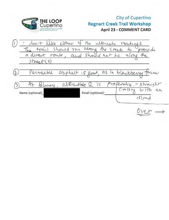
312
313
314
315
316
317
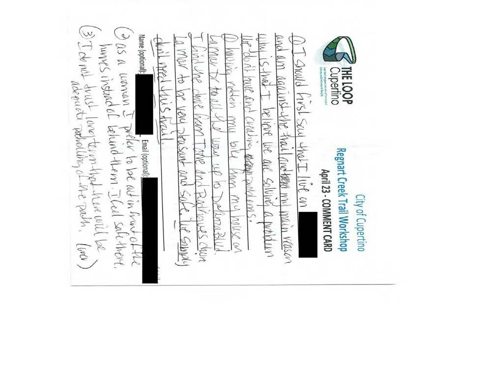
318
319
320
321
322
323
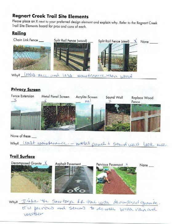
324
325
326
327
328
329

.j{}.")

![/11{, fly/) ;te,> U J (/vc/c clt()k /7 fjrv ctp.ri & I/ C.J] f: h -I ft!](/docs-images/83/88419523/images/330-4.jpg "> w /J vd 4 /z_e J UA f q b If. ;wf Jl,t, ti-;- - r1,-i; n:) 11-.,,,o ot.")
330 Regnart Creek Trail Site Elements Please place an X next to your preferred design element and explain why. Refer to the Regnart Creek Trail Site Elements board for pros and cons of each. Railing Chain Link Fence Split Rail Fence (wood).j{}. Split Rail Fence (steel) yj_ None.i}_ --. -,.,....:>--. II 11111,.... "'" -- # 1/ tt '., Why? /11{, fly/) ;te,> U J (/vc/c clt()k /7 fjrv ctp.ri & I/ C.J] f: h -I ft!> w /J vd 4 /z_e J UA f q b If. ;wf Jl,t, ti-;- - r1,-i; n:) 11-.,,,o ot.j. Privacy Screen Extension None of these Metal Panel Screen., Acrylite Screen Sound Wall DRAFT None
331
332
333
334
335
336
337
338
339
340
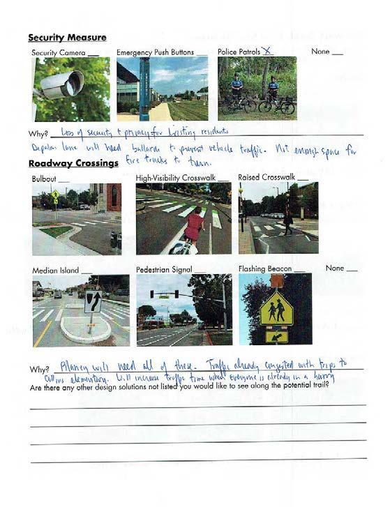
341
342
343
344
345


346 Regnart Creek Trail Site Elements Please place an X next to your preferred design element and explain why. Refer to the Regnart Creek Trail Site Elements board for pros and cons of each. Railing Chain Link Fence None Privacy Screen Fence Extension None of these Trail Surface Metal Panel Screen - -..e.l!w,.. :i:ii.,.,ij; :, Acrylite Screen DRAFT ;- Sound Wall Replace Wood Fence None C, C>"
347
348
349
350
351
352
353
354
355
356
357
358
359
360
361
362 THIS PAGE INTENTIONALLY LEFT BLANK DRAFT REGNART CREEK TRAIL
363 APPENDIX D SCVWD MEETING MINUTES SCVWD Coordination Meeting #1 Minutes SCVWD Coordination Meeting #2 Minutes SCVWD Coordination Meeting #3 Minutes DRAFT HMH D
364 THIS PAGE INTENTIONALLY LEFT BLANK DRAFT REGNART CREEK TRAIL
365 MEETING MINUTES SANTA CLARA VALLEY TRANSPORTATION AUTHORITY Regnart Creek Trail Feasibility Study Santa Clara Valley Water District (SCVWD) Kick-off Meeting Date and Time: November 28, :00 p.m. Location: SCVWD Offices, 5750 Almaden Expy San Jose, CA Minutes By: Attended By: Sue Tippets Usha Chatwani Cody Houston Devin Mody Brian Fletcher DISCUSSION HMH SCVWD SCVWD SCVWD SCVWD Callander David Stillman Jennifer Chu Jon Cacciotti Michelle Vera Cruz Jodi Starbird 1. Introductions & Key Staff a. Usha Chatwani SCVWD b. Jen Chu City of Cupertino c. Jon Cacciotti HMH Engineers 2. Project Description a. A portion of the Cupertino Loop known as Regnart Creek Trail is subject to a feasibility study conducted by HMH. The feasibility study is projected to be reviewed by Cupertino City Council in Spring b. The Regnart Creek Project would utilize the existing Regnart Creek maintenance access road from Pacifica Dr to the west to E. Estates Dr to the east. 3. SCVWD Long Term Plans a. SCVWD has an Asset Management Plan that describes the operations and maintenance work to be performed on existing SCVWD facilities. i. Regnart Creek is subject to routine maintenance such as vegetation removal and herbicide applications. b. Regnart Creek in the project area has known slope failures and SCVWD may have future slope stability projects. c. No specific capacity improvements for Regnart Creek are planned at this time. 4. SCVWD Creek History a. Current Creek Conditions i. Regnart Creek has been stable until the past few years. DRAFT City of Cupertino City of Cupertino HMH HMH David J. Powers ACTION 1
366 1. FEMA maps are outdated and are not representative of the current flooding status. 2. Erosion of the creek has caused incising of the creek bank. 3. SCVWD may not have a current model of this creek, however they do have information about flooding hotspots and problematic areas along the reach. 5. SCVWD Design Guidelines a. The project development team proposed to use the following Design Guidelines: i. SCVWD User Manual: Guidelines & Standards for Land Use Near Streams (Guide 16 Guidance for Trail Design) ii. Caltrans Highway Design Manual (Chapter 1000 Bikeway Planning and Design) iii. SCVWD indicated that the City of San Jose is underway with a document that will provide updated guidelines for creek trails. 1. This document will be adopted by SCVWD. 2. Draft document previously circulated. Final document expected early Project Specific Considerations a. Creek Maintenance Access Location i. Regnart Creek Trail must preserve SCVWD maintenance access including existing access ramp to the creek bed. ii. The existing concrete maintenance ramp down into the creek bed can be removed for trail continuity as long as a similar access ramp can be constructed elsewhere within the same reach. b. Proposed Bike/Ped Overcrossing Structures i. Two bike/ped bridges are proposed for user access points from Wilson Park and to deviate the trail away from the existing access ramp. ii. Structures that cross SCVWD creeks are allowed but are discouraged. c. SCVWD operates a Good Neighbor Program where SCVWD will pay ±50% of the capital cost of a new fence. The property owner is responsible for maintenance. 7. SCVWD Criteria Summary a. HMH summarized design criteria extracted from SCVWD User Manual and Santa Clara County Uniform Interjurisdictional Trail Design, Use, and Management Guidelines. b. HMH requested identification or other criteria not explicitly stated in the Trail Design Guide. SCVWD Identified the following criteria: i. Minimum access road width shall be 18 or match existing conditions. ii. Minimum trail paved width shall be 8 in areas where existing access road is narrow. iii. Grade trail away from the creek, allowing water to drain to existing outfalls. DRAFT SCVWD to provide information about known hotspots and problematic areas. HMH to request draft copy from the City of San Jose. SCVWD to provide minimum vertical clearance for maintenance vehicles within creek. 2
367 iv. Lighting along trail is not permitted. v. SCVWD regular maintenance of trail and associated closures should be properly conveyed and communicated to trail users through signage and public outreach. vi. SCVWD may need gates at all access points to close the trail for maintenance. vii. No physical separation between the creek and the trail is preferred, however to address safety concerns; low-height, open fencing is allowed. viii. SCVWD interested in alternative, permeable trail surfaces. ix. SCVWD indicated that a new joint-use agreement will need to be established between the City of Cupertino and SCVWD if the trail is constructed. DRAFT HMH to research alternative paving solutions for trail. 3
368 MEETING MINUTES SANTA CLARA VALLEY TRANSPORTATION AUTHORITY Regnart Creek Trail Feasibility Study Santa Clara Valley Water District (SCVWD) Kick-off Meeting Date and Time: April 4, :00 p.m. Location: SCVWD Offices, 5750 Almaden Expy San Jose, CA Minutes By: Attended By: Sue Tippets Usha Chatwani Cody Houston Devin Mody DISCUSSION HMH SCVWD SCVWD SCVWD SCVWD David Stillman Jennifer Chu Jon Cacciotti Michelle Vera Cruz 1. Introductions & Key Staff a. Usha Chatwani SCVWD b. David Stillman City of Cupertino c. Jon Cacciotti HMH Engineers 2. Project Status Update a. Two public outreach meetings, one Walkshop i. Primary concerns of the public are privacy, safety, and security. b. Proposed Improvements i. Various trail element alternatives aim to address the public s concerns ii. Bridge crossings at Wilson park are proposed in order to maintain SCVWD access ramp and to create a connection to Wilson Park. 3. Proposed Improvements a. Conceptual Alignment i. Trail alignment begins at the intersection of Torre Ave and Pacifica Dr and terminates at E Estates Drive before existing Regnart Creek trail tees into Creekside Park. ii. Trail alignment crosses Regnart Creek twice near Wilson Park to avoid existing SCVWD maintenance ramp. Bridges are proposed to achieve this crossing. b. Trail Features i. Railing DRAFT City of Cupertino City of Cupertino HMH HMH ACTION 1
369 1. To address safety concerns, railing along the top of bank, adjacent to the trail, is proposed for the entirety of the trail as the creek bank exceeds a 3:1 slope. 2. SCVWD opposes railing as it restricts maintenance and contributes to bank instability and erosion. 3. Slope instability and susceptibility to erosion increase as bank slopes increase. 4. City to evaluate liability concerns for pedestrian safety along steep banks. ii. Privacy Screening 1. Screening provided by fencing, fence extensions, soundwalls, and SCVWD to provide metal/acrylic panels are proposed to potentially address privacy City of Cupertino concerns. with fence costsharing agreement 2. Proposed privacy screen footprint shall be minimized and shall abut existing fencing to the extent practicable as to not decrease maintenance access width substantially. 3. SCVWD has a cost-sharing program for the replacement or installation of wooden or chain link fencing between District land and adjoining properties. City of Cupertino is to adopt similar cost-sharing agreement for fencing/screening installed by this project. iii. Safety Features 1. Security cameras and emergency push buttons may only be placed in public open spaces (road crossings, Civic Center), not along trail. 2. Yves Zsutty from the City of San Jose can provide insight on the feasibility of providing security measures along trails. iv. Trail Surface 1. Trail surfaces shall be capable to withstand loading from SCVWD large maintenance vehicles and machines. 2. Preferred SCVWD access width is Trail surface width DRAFTlanguage. shall be as wide as possible but not less than 12 wide. 4. Pervious pavement is the preferred trail surface as it will avoid C3 requirements. 5. No new outfalls are proposed. The project proposes to tie into the existing system. 6. Bioswales triggered by C3 treatment shall be minimized and shall abut existing fencing as to not decrease maintenance access widths substantially. v. Bride Crossing 2
370 vertical clearance from channel bottom to bridge deck is needed for maintenance equipment. 2. For maintenance purposes, access points to the trail shall have gates. 3. The maintenance ramp in this location is accessed approximately every 10 years. SCVWD is agreeable to removeable bridge structures that can be removed and preplaced by the City to facilitate creek work. 4. Next Steps a. Public Outreach i. Trail alignment and trail elements that address public concerns will be presented at the public outreach meeting on April 23, ii. Public preferences and SCWVD preferences will be considered and evaluated in order to arrive at a recommended trail design. DRAFT 3
371 MEETING MINUTES SANTA CLARA VALLEY TRANSPORTATION AUTHORITY Regnart Creek Trail Feasibility Study Santa Clara Valley Water District (SCVWD) Kick-off Meeting Date and Time: July 11, :00 a.m. Location: SCVWD Offices, 5750 Almaden Expy San Jose, CA Minutes By: Attended By: Sue Tippets Usha Chatwani Chad DISCUSSION HMH SCVWD SCVWD SCVWD David Stillman Jennifer Chu Jon Cacciotti Michelle Vera Cruz 1. Introductions & Key Staff a. Usha Chatwani SCVWD b. David Stillman City of Cupertino c. Jon Cacciotti HMH Engineers 2. Project Status Update a. Public Outreach Meeting & Meeting with Lozano Ln/De Palma Lane Residents i. Primary concerns of the public are privacy, safety, and security. ii. Creek structure alternatives presented to Lozano Ln/De Palma. If project was approved, Lozano Lane/De Palma Lane residents preferred the box culvert alternative. b. Trail Feasibility Study i. HMH is providing creek trail alternatives based on community, City, and SCWD input and will evaluate these alternatives based on, but not limited to, SCVWD maintenance access and environmental impacts 3. Recommended Improvements a. Railing i. Removable split railing is proposed along the edge of the trail, at least 2 from top of bank to allow for SCVWD maintenance and to not contribute to slope failures of creek bank. DRAFT City of Cupertino City of Cupertino HMH HMH ACTION SCVWD to provide vegetation maintenance schedule 1
372 b. Fencing i. Fence replacement is the proposed privacy screening alternative as other alternatives have a footprint that will reduce SCVWD maintenance access if constructed on the creek side of existing private fencing. c. Trail Surfacing i. Porous pavement is the proposed trail surface material to mitigate stormwater runoff. d. Alignment i. The box culvert and cantilevered trail alternatives adjacent to Lozano Lane and De Palma Lane are not recommended by the SCVWD due to major local and federal environmental implications regarding the creek. ii. Removable bridge crossings to and from Wilson park are recommended to make it possible for SCVWD to maintain the creek in this section. Bridges shall be as far away from existing creek maintenance ramp as feasible. 4. Next Steps a. Finalize Feasibility Study i. HMH will provide a draft study for SCVWD review by 8/1/2018 ii. Council meeting for project approval on 8/21/2018 DRAFT 2
373 APPENDIX E FEMA MAPS Flood Map Area Flood Insurance Rate Map DRAFT HMH E
374 THIS PAGE INTENTIONALLY LEFT BLANK DRAFT REGNART CREEK TRAIL
 Zone A, V, A99 With BFE or Depth Zone AE, AO, AH, VE, AR Regulatory Floodway 0.")
375 National Flood Hazard Layer FIRMette 37 19'24.19"N Legend SEE FIS REPORT FOR DETAILED LEGEND AND INDEX MAP FOR FIRM PANEL LAYOUT 122 1'45.20"W SPECIAL FLOOD HAZARD AREAS OTHER AREAS OF FLOOD HAZARD Without Base Flood Elevation (BFE) Zone A, V, A99 With BFE or Depth Zone AE, AO, AH, VE, AR Regulatory Floodway 0.2% Annual Chance Flood Hazard, Areas of 1% annual chance flood with average depth less than one foot or with drainage areas of less than one square mile Zone X Future Conditions 1% Annual Chance Flood Hazard Zone X Area with Reduced Flood Risk due to Levee. See Notes. Zone X Area with Flood Risk due to Levee Zone D Feet ,000 1,500 2,000 DRAFT USGS The National Map: Orthoimagery. Data refreshed October :6, '55.57"N 122 1'7.74"W OTHER AREAS GENERAL STRUCTURES OTHER FEATURES MAP PANELS NO SCREEN Area of Minimal Flood Hazard Zone X B Effective LOMRs Area of Undetermined Flood Hazard Zone D Channel, Culvert, or Storm Sewer Levee, Dike, or Floodwall Cross Sections with 1% Annual Chance 17.5 Water Surface Elevation Coastal Transect Base Flood Elevation Line (BFE) Limit of Study Jurisdiction Boundary Coastal Transect Baseline Profile Baseline Hydrographic Feature Digital Data Available No Digital Data Available Unmapped This map complies with FEMA's standards for the use of digital flood maps if it is not void as described below. The basemap shown complies with FEMA's basemap accuracy standards Ü The pin displayed on the map is an approximate point selected by the user and does not represent an authoritative property location. The flood hazard information is derived directly from the authoritative NFHL web services provided by FEMA. This map was exported on 7/18/2018 at 5:07:41 PM and does not reflect changes or amendments subsequent to this date and time. The NFHL and effective information may change or become superseded by new data over time. This map image is void if the one or more of the following map elements do not appear: basemap imagery, flood zone labels, legend, scale bar, map creation date, community identifiers, FIRM panel number, and FIRM effective date. Map images for unmapped and unmodernized areas cannot be used for regulatory purposes.
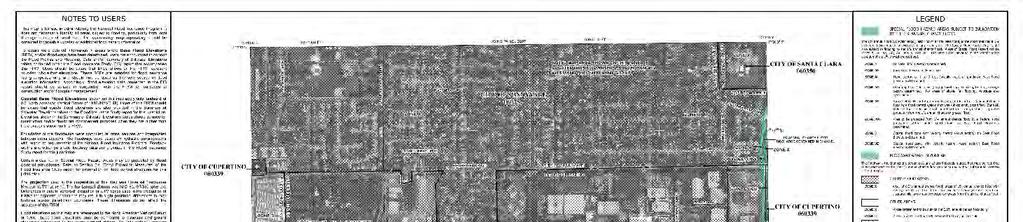
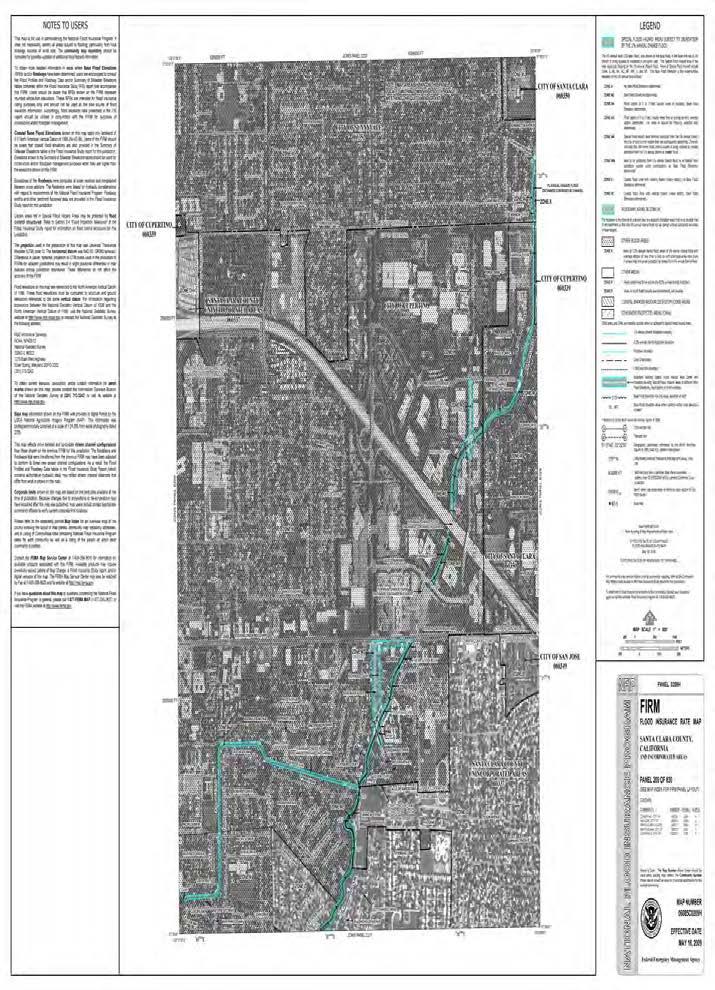
376
FEASIBILITY CRITERIA
 This chapter describes the methodology and criteria used to evaluate the feasibility of developing trails throughout the study areas. Land availability, habitat sensitivity, roadway crossings and on-street
Longmont to Boulder Regional Trail Jay Road Connection DRAFT FINAL REPORT
 Longmont to Boulder Regional Trail Jay Road Connection DRAFT FINAL REPORT December 2018 Project Summary Boulder County, Colorado, in partnership with the City of Boulder, is evaluating options for multi-use
CHAPTER III: TRAIL DESIGN STANDARDS, SPECIFICATIONS & PERMITS
 CHAPTER III Trail Design Standards, Specifications & Permits This chapter discusses trail standards, preferred surface types for different activities, permits, and other requirements one must consider
The Baker/Carver Regional Trail is intended to
 Section V Design Guidance The Baker/Carver Regional Trail is intended to safely accommodate 183,000 annual visits, an array of non-motorized uses, a variety of skill levels, and persons with special needs.
AGENDA ITEM 5 D WAKULLA ENVIRONMENTAL INSTITUTE (WEI) TRAIL FEASIBILITY STUDY
 TRAIL FEASIBILITY STUDY") March 19, 2018 AGENDA ITEM 5 D WAKULLA ENVIRONMENTAL INSTITUTE (WEI) TRAIL FEASIBILITY STUDY TYPE OF ITEM: Action STATEMENT OF ISSUE The Wakulla Environmental Institute (WEI) Trail is one of several trails
March 19, 2018 AGENDA ITEM 5 D WAKULLA ENVIRONMENTAL INSTITUTE (WEI) TRAIL FEASIBILITY STUDY TYPE OF ITEM: Action STATEMENT OF ISSUE The Wakulla Environmental Institute (WEI) Trail is one of several trails
ROAD AND TRAIL PROJECT APPROVAL
 ROAD AND TRAIL PROJECT APPROVAL www.marincountyparks.org Marin County Parks, 3501 Civic Center Dr, Suite 260, San Rafael, CA 94903 DATE: July 12, 2017 PRESERVE: Gary Giacomini Open Space Preserve PROJECT:
Blueways: Rivers, lakes, or streams with public access for recreation that includes fishing, nature observation, and opportunities for boating.
 Parks, Open Space and Trails PRINCE WILLIAM COUNTY 2008 COMPREHENSIVE PLAN TRAILS PLAN CONTENTS The components of the trails plan are: Intent Definitions Goals, Policies, and Action Strategies Trails Map
4. Safety Concerns Potential Short and Medium-Term Improvements
 NH Route 104 Access Management Study Page 19 4. Safety Concerns Potential Short and Medium-Term Improvements Potential safety improvement strategies are listed by priority based on field observations by
Blue River Trail Master Plan JSA to Town Hall June 2004
 Blue River Trail Master Plan JSA to Town Hall June 2004 Prepared for: Silverthorne Town Council Silverthorne SPORT Committee Department of Recreation and Culture Silverthorne Public Works Silverthorne
EAST DON TRAIL ENVIRONMENTAL ASSESSMENT. Community Liaison Committee Meeting #3 July 15, :30 to 8:30 pm Flemingdon Park Library
 EAST DON TRAIL ENVIRONMENTAL ASSESSMENT Community Liaison Committee Meeting #3 July 15, 2013 6:30 to 8:30 pm Flemingdon Park Library Agenda 1. Welcome 2. Housekeeping and Updates a) Housekeeping b) CLC
Appendix 3. Greenway Design Standards. The Whitemarsh Township Greenway Plan
 Appendix 3 Greenway Design Standards This chapter discusses two design standards for the greenway types discussed above. First, trail design standards are presented together with trailhead facilities and
MORGAN CREEK GREENWAY Final Report APPENDICES
 APPENDICES MORGAN CREEK GREENWAY Appendix A Photos of Existing Conditions in Trail Corridor Photos of existing conditions Main trail corridor - February 2009 Photos of existing conditions south bank Morgan
Rule Governing the Designation and Establishment of All-Terrain Vehicle Use Trails on State Land
 Rule Governing the Designation and Establishment of All-Terrain Vehicle Use Trails on State Land 1.0 Authority 1.1 This rule is promulgated pursuant to 23 V.S.A. 3506. Section 3506 (b)(4) states that an
3. COLTA / HUGA CONNECTIONS - PRELIMINARY
 9 3. COLTA / HUGA CONNECTIONS - PRELIMINARY 3.1 COLTA The Chain of Lakes Trail Association (COLTA) trail, formerly identified as the Chester Spur Line, was completed and opened for use in June 2011. The
PURPOSE AND NEED (CONCURRENCE POINT 1) NEW CANADA ROAD PROJECT FROM STATE ROUTE 1 (U.S. HIGHWAY 70) TO U.S. INTERSTATE 40
 NEW CANADA ROAD PROJECT FROM STATE ROUTE 1 (U.S. HIGHWAY 70) TO U.S. INTERSTATE 40") PURPOSE AND NEED (CONCURRENCE POINT 1) NEW CANADA ROAD PROJECT FROM STATE ROUTE 1 (U.S. HIGHWAY 70) TO U.S. INTERSTATE 40 Project Description The primary purpose of this project is to improve the major
PURPOSE AND NEED (CONCURRENCE POINT 1) NEW CANADA ROAD PROJECT FROM STATE ROUTE 1 (U.S. HIGHWAY 70) TO U.S. INTERSTATE 40 Project Description The primary purpose of this project is to improve the major
BACKCOUNTRY TRAIL FLOOD REHABILITATION PROGRAM
 BACKCOUNTRY TRAIL FLOOD REHABILITATION PROGRAM Backcountry Trail Flood Rehabilitation A June 2013 Flood Recovery Program Summary In June 2013, parts of Southern Alberta were devastated from significant
Business Item No XXX. Proposed Action That the Metropolitan Council approve the Coon Creek Regional Trail Master Plan.
 Business Item No. 2015-XXX Metropolitan Parks and Open Space Commission Meeting date: July 7, 2015 For the Community Development Committee meeting of July 20, 2015 For the Metropolitan Council meeting
COASTAL CONSERVANCY. Staff Recommendation September 22, 2011 BAY AREA RIDGE TRAIL: HOOD MOUNTAIN TO HIGHWAY 12
 COASTAL CONSERVANCY Staff Recommendation September 22, 2011 BAY AREA RIDGE TRAIL: HOOD MOUNTAIN TO HIGHWAY 12 File No. 11-039-001 Project Manager: Betsy Wilson RECOMMENDED ACTION: Authorization to disburse
Becker County Trail Routing Feasibility Study
 2016 Becker County Trail Routing Feasibility Study CONNECTING DETROIT MOUNTAIN AND MOUNTAIN VIEW RECREATIONAL AREA TO THE HEARTLAND TRAIL BECKER COUNTY ULTEIG ENGINEERS Contents Acknowledgements...2 INTRODUCTION...3
COASTAL CONSERVANCY. Staff Recommendation December 2, 2004 COYOTE HELLYER COUNTY PARK BAY AREA RIDGE TRAIL
 COASTAL CONSERVANCY Staff Recommendation December 2, 2004 COYOTE HELLYER COUNTY PARK BAY AREA RIDGE TRAIL File No. 04-057 Project Manager: Amy Hutzel RECOMMENDED ACTION: Authorization to disburse up to
Community Development
 Community Development City & Borough of Juneau Community Development 155 S. Seward Street Juneau, AK 99801 (907) 586 0715 Phone (907) 586 4529 Fax DATE: February 11, 2016 TO: FROM: Planning Commission
DATE: 23 March, 2011 TO: Communities FROM: BlazeSports America. RE: Accessible Trails Checklist 1
 M E M O R A N D U M DATE: 23 March, 2011 TO: Communities FROM: BlazeSports America RE: Accessible Trails Checklist 1 The purpose of the Accessible Trails Checklist (below) is to help the community review
Welcome to the Cross County Trail Public Input Session!
 Welcome to the Cross County Trail Public Input Session! Please sign in on the table below! What are we doing here? Camden County has proposed a bicycle and pedestrian trail spanning across the entire county.
Uniform Interjurisdictional Trail Design, Use, and Management Guidelines
 Uniform Interjurisdictional Trail Design, Use, and Management Guidelines In Fulfillment of County General Plan Policy PR-TS(i) 6A) Santa Clara County Interjurisdictional Trails Committee A Program of the
City of Durango 5.8 FUNDING TRAILS DEVELOPMENT
 5.8 FUNDING TRAILS DEVELOPMENT The City has been successful in establishing dedicated local funding sources as well as applying for grants to develop the City s trail system, having received nearly $2.4
Chapter 4.0 Alternatives Analysis
 Chapter 4.0 Alternatives Analysis Chapter 1 accumulated the baseline of existing airport data, Chapter 2 presented the outlook for the future in terms of operational activity, Chapter 3 defined the facilities
SAN FRANCISCO MUNICIPAL TRANSPORTATION AGENCY
 THIS PRINT COVERS CALENDAR ITEM NO. : 10.4 DIVISION: Sustainable Streets BRIEF DESCRIPTION: SAN FRANCISCO MUNICIPAL TRANSPORTATION AGENCY Approving various parking and traffic modifications associated
Daisy Dean Trail 628/619 ATV Trail Construction
 Background and Purpose and Need The Daisy Dean ATV Trail Construction Project is located in the Little Belt Mountains, Musselshell Ranger District, Lewis and Clark National Forest approximately 32 miles
FINAL. Bicycle/Pedestrian Feasibility Study City of DeBary Dirksen Drive Trail. Prepared For: Volusia County MPO
 City of DeBary Dirksen Drive Trail FINAL Prepared By: Reynolds, Smith and Hills, Inc. Prepared For: Volusia County MPO September 2007 Table of Contents INTRODUCTION...1 PROJECT PURPOSE AND SCOPE...2 PHYSICAL
2016 Regional Transportation Alternatives Program (TAP) Grant Application
 Grant Application") 2016 Regional Transportation Alternatives Program (TAP) Grant Application PROJECT TITLE: Yelm-Tenino Trail Extension Feasibility Study TRPC use only GENERAL PROJECT INFORMATION Agency or Organization City
2016 Regional Transportation Alternatives Program (TAP) Grant Application PROJECT TITLE: Yelm-Tenino Trail Extension Feasibility Study TRPC use only GENERAL PROJECT INFORMATION Agency or Organization City
Committee Report. Community Development Committee For the Metropolitan Council meeting of April 13, Business Item No.
 Committee Report Business Item No. 2016-48 Community Development Committee For the Metropolitan Council meeting of April 13, 2016 Subject: Harriet Island-South St. Paul Regional Trail Master Plan, Saint
Georgetown-Lewes Rail/Trail Study. Rail/Trail Study: Cool Spring to Cape Henlopen State Park New Road Extension (House Resolution No.
 Georgetown-Lewes Rail/Trail Study Rail/Trail Study: Cool Spring to Cape Henlopen State Park New Road Extension (House Resolution No. 47) August 22, 2011 Presentation Outline Background Benefits Statewide
MONTGOMERY COUNTY PLANNING DEPARTMENT THE MARYLAND-NATIONAL CAPITAL PARK AND PLANNING COMMISSION
 MONTGOMERY COUNTY PLANNING DEPARTMENT THE MARYLAND-NATIONAL CAPITAL PARK AND PLANNING COMMISSION MCPB Item No. Date: 6/23/2016 Lucy V. Barnsley Elementary School Addition, Mandatory Referral MR2016027
Committee Report. Community Development Committee For the Metropolitan Council meeting of August 12, Business Item No.
 Committee Report Business Item No. 2015-168 Community Development Committee For the Metropolitan Council meeting of August 12, 2015 Subject: Coon Creek Regional Trail Master Plan, Anoka County Proposed
Madison Metro Transit System
 Madison Metro Transit System 1101 East Washington Avenue Madison, Wisconsin, 53703 Administrative Office: 608 266 4904 Fax: 608 267 8778 TO: FROM: SUBJECT: Plan Commission Timothy Sobota, Transit Planner,
Rural Rustic Road Program
 Virginia Department of Transportation s Rural Rustic Road Program Prepared by the Local Assistance Division Virginia Department of Transportation 1401 East Broad Street Richmond, Virginia 23219 Michael
Section II. Planning & Public Process Planning for the Baker/Carver Regional Trail began in 2010 as a City of Minnetrista initiative.
 Section II Planning & Public Process Planning for the began in 2010 as a City of initiative. city staff began discussions with the Park District on the possibility of a north/south regional trail connection
ALBANY-HUDSON ELECTRIC TRAIL FEASIBILITY STUDY. Final Report OCTOBER 2011
 ALBANY-HUDSON ELECTRIC TRAIL FEASIBILITY STUDY Final Report OCTOBER 2011 ALBANY-HUDSON ELECTRIC TRAIL FEASIBILITY STUDY Prepared for: Town of East Greenbush 225 Columbia Turnpike Rensselaer, New York 12144
Site Location and Setting
 Memorandum Date: To: From: Subject: Kristy Le, Gary Black Steve Orem Santa Teresa County Park Historic Area Traffic and Parking Study Hexagon Transportation Consultants, Inc. has completed a traffic and
Public Notice ISSUED: December 10, 2018 EXPIRES: January 9, 2019
 APPLICANT: REFER TO: St. Louis and Lake Counties Regional Rail Authority 2018-01942-ARC Public Notice ISSUED: December 10, 2018 EXPIRES: January 9, 2019 SECTION:404 - Clean Water Act 1. APPLICATION FOR
Chapter 6: POLICY AND PROCEDURE RECOMMENDATIONS
 Chapter 6 POLICY AND PROCEDURE RECOMMENDATIONS FOR SRRA Below are seven policy elements that should be considered for adoption by the Southwest Regional Recreation Authority of Virginia: 1. Develop strategies
The following criteria shall be applied within the boundaries of the AO District:
 Sec. 419 (a) Purpose AIRPORT OVERLAY DISTRICT (AO) The purpose of the Airport Overlay District is to regulate and restrict the height of structures, objects, or natural growth, regulate the locations of
DECISION MEMO. Rawhide Trail #7073 Maintenance and Reconstruction
 Page 1 of 6 Background DECISION MEMO USDA Forest Service Jefferson Ranger District Jefferson County, Montana Rawhide Trail #7073 is located in the Elkhorn Mountain Range approximately 10 miles east of
Chatsworth Branch Library Devonshire Street, Chatsworth, CA Thursday, November 16, :00-8:00 pm
 Chatsworth Branch Library 21052 Devonshire Street, Chatsworth, CA 91311 Thursday, November 16, 2017 6:00-8:00 pm Project Team County of Los Angeles Department of Parks and Recreation Kathline King Chief
Auburn Trail / Ontario Pathways Trail Connector Feasibility Study Public Information Meeting Wednesday, August 22, 2012
 Auburn Trail / Ontario Pathways Trail Connector Feasibility Study Public Information Meeting Wednesday, August 22, 2012 Purpose of Feasibility Study Purpose Evaluate the feasibility of constructing a multiuse
Finn Creek Park. Management Direction Statement Amendment
 Finn Creek Park Management Direction Statement Amendment November 2013 Management Direction Statement Amendment Approved by: Jeff Leahy Regional Director, Thompson Cariboo BC Parks November 12, 2013 Date
Citrus Heights Creek Corridor Trail Project Trail Advisory Group Field Trip #2 September 11, :00 11:00 am Trellis Hall, Citrus Heights
 September 11, 2013 9:00 11:00 am Trellis Hall, Citrus Heights Project Overview The City of Citrus Heights is studying the feasibility of establishing a multi use trail system within the City s 26 miles
Lafourche Parish Government REQUEST FOR QUALIFICATIONS. Landscape Architectural Services
 Lafourche Parish Government REQUEST FOR QUALIFICATIONS Landscape Architectural Services Bayou Lafourche Parish Multi-Use Path Feasibility Study Phase 1 And Bayou Lafourche Parish Multi-Use Path Feasibility
Section 106 Update Memo #1 Attachment D. Traffic Diversion & APE Expansion Methodology & Maps
 Section 106 Update Memo #1 Attachment D Traffic Diversion & APE Expansion Methodology & Maps I-65/I-70 North Split Interchange Reconstruction Project (Des. Nos. 1592385 & 1600808) Traffic Diversion and
Northaven Trail Phase 2 Initial Project Overview
 Northaven Trail Phase 2 Initial Project Overview Partnership Project to extend existing Northaven Trail Improve Bike/Ped Connectivity On Dallas Trail Network Plan City and County Funding Oncor Texas Trails
Stevenson Ranch Library The Old Road, Stevenson Ranch, CA Thursday, November 9, :00-8:00 pm
 Stevenson Ranch Library 25950 The Old Road, Stevenson Ranch, CA 91381 Thursday, November 9, 2017 6:00-8:00 pm Project Team County of Los Angeles Department of Parks and Recreation Kathline King Chief of
Attachment No. 20 RRLRT No. 1. Committee. Busway Grade Crossings STATUS/DATE OF ACTION
 Attachment No. 20 RRLRT No. 1 TECHNICAL COMMITTEE: Railroad / Light Rail Transit Technical Committee TOPIC: Busway Grade Crossings STATUS/DATE OF ACTION RRLRT TC Draft: 06/23/2011 RRLRT TC Approval: 06/27/2014
Agenda Report. Spruce Street Outlet Drainage Improvements Tower Road Relief Sewer
 Agenda Report Subject: Prepared By: Spruce Street Outlet Drainage Improvements Tower Road Relief Sewer Steven M. Saunders, Director of Public Works/Village Engineer Date: August 12, 2012 On March 8, 2012
A number of goals were identified during the initial work on this Big Lake Transportation Plan.
 C. Transportation General Background Information Big Lake s transportation system includes all the roads, paths and facilities that allow the movement of private vehicles, trains and planes, as well as
Trail # NW Tuesday, June DESIGN. Provide an Review the Provide an. Project Goals: System system. wayfinding
 I. Welcome / Introductions Bethany Creek Trail #2 Segment 3 Neighborhood Meeting #1 Bethany Presbyterian Church 15505 NW Springville Road, Portland, OR 97229 Tuesday, June 26, 2018 @ 6:00PM Meeting Minutes
A. CONCLUSIONS OF THE FGEIS
 Chapter 11: Traffic and Parking A. CONCLUSIONS OF THE FGEIS The FGEIS found that the Approved Plan will generate a substantial volume of vehicular and pedestrian activity, including an estimated 1,300
SR 934 Project Development And Environment (PD&E) Study
 Study") SR 934 Project Development And Environment (PD&E) Study Project Advisory Group Meeting March 1, 2018 State Road 934/NE/NW 79th Street from west of I-95 (NW 13th CT) to N. Bayshore Drive PD&E STUDY SR 934/NE/NW
SR 934 Project Development And Environment (PD&E) Study Project Advisory Group Meeting March 1, 2018 State Road 934/NE/NW 79th Street from west of I-95 (NW 13th CT) to N. Bayshore Drive PD&E STUDY SR 934/NE/NW
ANCLOTE COASTAL TRAIL ALTERNATIVES ANALYSIS STUDY
 ANCLOTE COASTAL TRAIL ALTERNATIVES ANALYSIS STUDY PASCO COUNTY MPO JULY 2015 PROJECT OVERVIEW... INTRODUCTION EXECUTIVE SUMMARY CONTEXT... TAMPA BAY AREA, PINELLAS, & PASCO COUNTY S MULTI-USE TRAIL PLANS
Appendix L Technical Memorandum Aesthetics
 Technical Memorandum Aesthetics 1.0 AESTHETICS This section provides a discussion of the aesthetic resources in the vicinity of ARTIC. Aesthetics pertain to the elements that make a certain view pleasing
2. Goals and Policies. The following are the adopted Parks and Trails Goals for Stillwater Township:
 D. PARKS AND TRAILS 1. Introduction Stillwater Township s population is relatively low, with most residents living on rural residences on large lots. The need for active park space has been minimal in
Public Workshop Preliminary Plans Review. Projects PW 1605, 1701, & 1702
 Queens Mirror Circle Pedestrian Safety Improvements Quail Pond Circle Complete Street/Pedestrian Connectivity Improvements Southcot Drive Bicycle/Pedestrian Improvements Public Workshop Preliminary Plans
Other Principle Arterials Minor Arterial Major Collector Minor Collector Local
 CHAPTER 10 TRANSPORTATION Introduction The system of public roads in East Pikeland Township is decidedly rural in character. Since the 1984, the road network has remained much the same, with the addition
Understanding user expectations And planning for long term sustainability 1
 Understanding user expectations And planning for long term sustainability 1 What is a natural surface trail? It can be as simple has a mineral soil, mulched or graveled pathway, or as developed as elevated
4.0 Context for the Crossing Project
 4.0 Context for the Crossing Project This section provides background information about key features of the North Douglas Crossing project area, and opportunities and constraints. This information is important
Lake Erie Commerce Center Traffic Analysis
 LOCATION: East of NYS Route 5 at Bayview Road Town of Hamburg Erie County, New York PREPARED BY: Wendel Companies 140 John James Audubon Parkway Suite 200 Amherst, New York 14228 January 2012 i ii Table
Decision Memo Broken Wheel Ranch Equestrian Outfitter Special-Use Permit Proposed Action
 Decision Memo Broken Wheel Ranch Equestrian Outfitter Special-Use Permit USDA Forest Service Mississippi Bluffs Ranger District, Shawnee National Forest Jackson and Union Counties, Illinois Proposed Action
At the time, the portion of the line through Eagle County remains wholly under the ownership of Union Pacific Railroad (UP).
.") Chapter 5 The Railroad Corridor as a Trail Corridor The intent of this chapter is to identify how the rail corridor, if available for lease or purchase in all or part, could be incorporated into the core
Chapter 5 The Railroad Corridor as a Trail Corridor The intent of this chapter is to identify how the rail corridor, if available for lease or purchase in all or part, could be incorporated into the core
Procedure for the Use of Power-Driven Mobility Devices on Mass Audubon Sanctuaries 1 September 17, 2012
 Procedure for the Use of Power-Driven Mobility Devices on Mass Audubon Sanctuaries 1 September 17, 2012 Background As part of Mass Audubon s mission to preserve the nature of Massachusetts for people and
HIGHWAY 17 WILDLIFE and REGIONAL TRAIL CROSSINGS
 HIGHWAY 17 WILDLIFE and REGIONAL TRAIL CROSSINGS Agenda and Meeting Format 7:00-7:15 Welcome 7:15-8:00 Presentation 8:00-8:30 Open House 8:30 Recap 9:00 Conclusion 2 Meeting Goals: Introduce the project
C. APPROACH FOR IDENTIFYING THE BEST ROUTES FOR THE NEEDED TRANSMISSION SYSTEM IMPROVEMENTS
 C. APPROACH FOR IDENTIFYING THE BEST ROUTES FOR THE NEEDED TRANSMISSION SYSTEM IMPROVEMENTS CL&P s approach for identifying the best routes for the needed transmission system improvements included a determination
Little River Trail Feasibility Study
 Final April, 2014 Prepared for the State Coastal Conservancy By the Natural Resources Services Division of Redwood Community Action Agency Table of Contents Executive Summary... 1 1. Project Purpose and
Citrus Heights Creek Corridor Trail Project. Trail Advisory Group Meeting #3 July 8, 2013
 Citrus Heights Creek Corridor Trail Project Trail Advisory Group Meeting #3 July 8, 2013 Agenda Introductions Recap: Community Workshop, Survey Findings, and TAG Field Trip Community Concern Discussion:
Airport Planning Area
 PLANNING AREA POLICIES l AIRPORT Airport Planning Area LOCATION AND CONTEXT The Airport Planning Area ( Airport area ) is a key part of Boise s economy and transportation network; it features a multi-purpose
TRAIL ANNUAL REPORT
 TRAIL ANNUAL REPORT 2016-17 Identify Undeveloped projects identified in the City s Greenprint or trail database 15.90 miles Study Projects that have been or are currently being studied to determine a feasible
HIGHWAY RAIL GRADE CROSSING CONSOLIDATION PROGRAM
 HIGHWAY RAIL GRADE CROSSING CONSOLIDATION PROGRAM To decrease unnecessary train traffic exposure to life and property, promote public safety, and improve traffic conditions, the Texas Department of Transportation
Non-Motorized Transportation
 Non-Motorized Transportation Non-motorized facilities are important components to the transportation system. They provide an environmentally-friendly, low-cost mode of travel. Some of the facilities can
Flying Cloud Airport (FCM) Zoning Process: Informing a Mn/DOT Path Forward
 Zoning Process: Informing a Mn/DOT Path Forward") : Informing a Mn/DOT Path Forward A Review of the Flying Cloud Airport (FCM) Joint Airport Zoning Board (JAZB) Process and the Draft Airport Zoning Ordinance B A RPZ RPZ A B C Zone Chad E. Leqve Director
: Informing a Mn/DOT Path Forward A Review of the Flying Cloud Airport (FCM) Joint Airport Zoning Board (JAZB) Process and the Draft Airport Zoning Ordinance B A RPZ RPZ A B C Zone Chad E. Leqve Director
Memo. Orange City Trail Plan Becky Mendez, AICP Jamie Krzeminski, PE, PTOE Matt Wiesenfeld, PE, AICP. Development of the Existing and Proposed Network
 Memo Date: Friday, December 22, 2017 Project: To: From: Subject: Trail Plan Becky Mendez, AICP Jamie Krzeminski, PE, PTOE Matt Wiesenfeld, PE, AICP Development of the Existing and Proposed Network HDR
Bradley Brook Relocation Project. Scoping Notice. Saco Ranger District. United States Department of Agriculture Forest Service
 Bradley Brook Relocation Project United States Department of Agriculture Forest Service Scoping Notice White Mountain National Forest February 2011 For Information Contact: Jenny Burnett White Mountain
Bear Creek Habitat Improvement Project
 06/10/10 Bear Creek Habitat Improvement Project El Paso County, Colorado Pike National Forest and Colorado Springs Utilities Owned Land Report prepared by: Eric Billmeyer Executive Director Rocky Mountain
Continental Divide National Scenic Trail Legislative History and Planning Guidance
 Continental Divide National Scenic Trail Legislative History and Planning Guidance Legislation, Policy, and Direction Regarding National Scenic Trails The National Trails System Act, P.L. 90-543, was passed
Mt. Hood National Forest
 United States Department of Agriculture Forest Service Mt. Hood National Forest Zigzag Ranger District 70220 E. Highway 26 Zigzag, OR 97049 503-622-3191 Fax: 503-622-5622 File Code: 1950-1 Date: June 29,
Chuckanut Ridge Fairhaven Highlands EIS Scoping Concerns
 Chuckanut Ridge Fairhaven Highlands EIS Scoping Concerns Coalition of Southside Neighborhoods CSN Comments for Fairhaven Highlands EIS Scope Hearing, Jan 16, 2008 1 Chuckanut Ridge Hilly Terrain: Potential
COMMUNITY MEETING NOVEMBER 1, Wheaton Regional Park Pine Lake Trail
 COMMUNITY MEETING NOVEMBER 1, 2012 MEETING AGENDA I. Introduction of Project Team II. Trail Renovation Process III. Wheaton Regional Park IV. Pine Lake Trail Renovation Project V. Comments and Questions
Chapter 6. Action Program. Heart of the Lakes Area Recreation Plan
 Heart of the Lakes Area Recreation Plan 1. Design and construct the following trails (please see the following map): a. the Speedway Trail 1) primary pathway the main trail 2) secondary pathway the proposed
Draft Concept Alternatives Analysis for the Inaugural Airport Program September 2005
 Section 10 Preferred Inaugural Airport Concept 10.0 Introduction The Preferred Inaugural Airport Concept for SSA was developed by adding the preferred support/ancillary facilities selected in Section 9
Outdoor Developed Areas
 The United States Access Board is an independent federal agency that promotes equality for people with disabilities through leadership in accessible design and the development of accessibility guidelines
What s covered. What s not covered. Options for those not covered. ABA Coverage
 The United States Access Board is an independent federal agency that promotes equality for people with disabilities through leadership in accessible design and the development of accessibility guidelines
SUMMER VILLAGE OF SILVER SANDS. Municipal Development Plan
 SUMMER VILLAGE OF SILVER SANDS Municipal Development Plan Bylaw 253-2014 Adopted August 22, 2014 Summer Village of Silver Sands Municipal Development Plan Bylaw No. 253-2014 Page 2 1 INTRODUCTION 1.1 SETTING
MPRB: Southwest LRT Community Advisory Committee Issues and Outcomes by Location Current to: 12 November 2010
 MPRB: Southwest LRT Community Advisory Committee Issues and Outcomes by Location Current to: 12 November 2010 This is a compilation of issues and outcomes identified by the CAC. It is a work in progress,
Section 4(f) and Section 6(f) Technical Analysis
 and Section 6(f) Technical Analysis") WESTSIDE SUBWAY EXTENSION PROJECT Contract No. PS-4350-2000 Section 4(f) and Section 6(f) Technical Analysis Prepared for: Prepared by: WSP USA 851 SW Sixth Avenue, Suite 1600 Portland, Oregon 97204 FEBRUARY
WESTSIDE SUBWAY EXTENSION PROJECT Contract No. PS-4350-2000 Section 4(f) and Section 6(f) Technical Analysis Prepared for: Prepared by: WSP USA 851 SW Sixth Avenue, Suite 1600 Portland, Oregon 97204 FEBRUARY
MONTEREY REGIONAL AIRPORT MASTER PLAN TOPICAL QUESTIONS FROM THE PLANNING ADVISORY COMMITTEE AND TOPICAL RESPONSES
 MONTEREY REGIONAL AIRPORT MASTER PLAN TOPICAL QUESTIONS FROM THE PLANNING ADVISORY COMMITTEE AND TOPICAL RESPONSES Recurring topics emerged in some of the comments and questions raised by members of the
APPENDIX F List of Commitments
 APPENDIX F List of Commitments s Table F.1 Standard Mitigation Measures Mitigation Measure MnDOT Specification Number Status Update Description Status Update Utilities Provide early notice to utility operators
Gold Coast. Rapid Transit. Chapter twelve Social impact. Chapter content
 Gold Coast Rapid Transit Chapter twelve Social impact Chapter content Social impact assessment process...235 Existing community profile...237 Consultation...238 Social impacts and mitigation strategies...239
12, 14 and 16 York Street - Amendments to Section 16 Agreement and Road Closure Authorization
 REPORT FOR ACTION 12, 14 and 16 York Street - Amendments to Section 16 Agreement and Road Closure Authorization Date: April 27, 2018 To: Toronto and East York Community Council From: Senior Strategic Director,
LYNDHURST NEW URBAN DEVELOPMENT AREA STRUCTURE PLAN. Lyndhurst New Urban Development Area Structure Plan OUTCOMES AND PERFORMANCE STANDARDS
 APPENDIX 15.1-3 LYNDHURST NEW URBAN DEVELOPMENT AREA STRUCTURE PLAN Purpose of the Structure Plan Lyndhurst New Urban Development Area Structure Plan OUTCOMES AND PERFORMANCE STANDARDS LSP-P1 The District
Parkland County Municipal Development Plan Amendment Acheson Industrial Area Structure Plan
 Parkland County Municipal Development Plan Amendment Acheson Industrial Area Structure Plan New Plan Acheson Industrial Area Structure Plan Amendment Parkland County Municipal Development Plan Board Reference
Spencer Environmental Appendix A: Alternative Analysis for Construction Access Route
 Spencer Environmental Appendix A: Alternative Analysis for Construction Access Route February 2015 Valley ine-stage 1 RT EISA Update FINA REPORT Page A1 Memorandum AECOM ConnectEd Transit Partnership 10235
Virginia Department of Transportation s Rural Rustic Road Program
 Virginia Department of Transportation s Rural Rustic Road Program Prepared by the Local Assistance Division Virginia Department of Transportation 1401 East Broad Street Richmond, Virginia 23219 Michael
URBAN DESIGN REPORT. Proposed Residential Development, Old Church Road, Caledon East
 Proposed Residential Development, Old Church Road, Caledon East TABLE CONTENTS: 1.0 DEVELOPMENT 1.1 Introduction-Analysis of Guiding Principles and Documents 1.2 Community Design and Architectural Design