Arizona National Scenic Trail
|
|
|
- Evelyn Barker
- 5 years ago
- Views:
Transcription
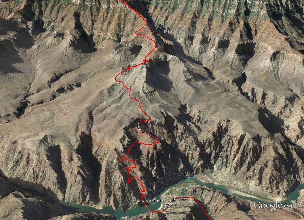
1 1

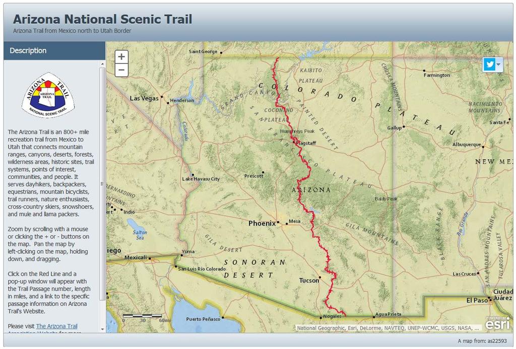
2 The Arizona National Scenic Trail is an 800 mile recreation trail from Mexico to Utah that connects mountain ranges, canyons, deserts, forests, wilderness areas, historic sites, trail systems, points of interest, communities, and people. It serves dayhikers, backpackers, equestrians, mountain bicyclists, trail runners, nature enthusiasts, crosscountry skiers, snowshoers, and mule and llama packers. Arizona National Scenic Trail The trail can also be described in two other ways; for its features, and for the experience it provides. The Arizona Trail Association (ATA) is a non-profit membership organization, seeking active supporters of the Trail, coordinating volunteers, and provides other essential services to those that use the Arizona Trail. ATA s Mission : To coordinate the planning, development, management, and promotion of the Arizona Trail for the recreational and educational experiences of non-motorized trail users. 2
3 The Arizona Trail was the dream of Dale Shewalter who envisioned a cross-state trail in the 1970s, and in 1985, while he was working as a Flagstaff schoolteacher, walked from Nogales to the Utah state line to explore the feasibility of a trail traversing Arizona. The Arizona Trail is a multi-user, non-motorized trail that travels through 8 Wilderness Areas but there are routes for mountain bikers around these areas. In 1994, the Arizona Trail Association incorporated as a 501(c)(3) non-profit organization and became an organized voice for the trail that is funded by members, donations, business partners, and grants. Since 2000, some very significant milestones have been reached that originally seemed very difficult to achieve. These include: Establishing easements and successfully building the trail on State Trust Lands (i.e., that is managed much like private land) in Pima and Pinal Counties Working to reestablish the trail in areas severely affected by major wildfires and traversing the challenging topography in many places within Arizona. An association that provides detailed maps, trail descriptions, connecting communities of Arizona along the trail as Gateway Communities, fun events on an around the trail, trail work weekends to improve and repair the trail and education through outreach to engage and include people to help protect the trail corridor and the biodiversity that the trail crosses. The Arizona Trail was designated as a National Scenic Trail on March 30, The Arizona National Scenic Trail was completed on December 16, 2011 just east of Florence. 3

4 Only 11 National Scenic Trails in the country, the Arizona Trail is only the 3rd to be completed, after the Appalachian Trail and the Pacific Crest Trail National Scenic Trails: Appalachian Trail Arizona Trail Continental Divide Trail New England Trail Florida Trail Ice Age Trail Natchez Trace Trail North Country Trail Pacific Crest Trail Pacific Northwest Trail Potomac Heritage Trail 4

5 What has GIS & ArcGIS Online provided for the Arizona Trail? Merged 43 passages and 800 miles of Garmin GPS data into one GIS layer rather than separate GPX files Central hub online as a source of geography Professional maps for publications like the The Complete Guide to the Arizona National Scenic Trail, published in 2013 and available as a printed softcover or ebook available at and many recreational stores across Arizona Improved precision of data points and lines representing the trail and easily shared data to other agencies across Arizona Online and interactive access to a variety of maps linking locations to features and stories about on the trail 5
 6")
6 Nature Valley in the Tusayan IMAX (South Rim of the Grand Canyon) 6


7 Passage Maps, Profiles, and Descriptions 7

8 Manually re-digitized the entire Arizona Trail Partnership project with the USFS to improve the precision of the line that represents the Arizona trail Used the ATA GPS tracks as a guide to digitize at 1:1200 scale. Used high resolution aerial imagery from ESRI, surface data, and GPS data, to draw a more exact line representing the trail Worked closely with GIS contacts at each Arizona National Forest to supply this data for their own GIS Databases and add to their maps. Plus work to keep updating them in the future Continuously updating the downloadable Arizona Trail line dataset already available on AZ GEO and now a link to the feature service hosted on ArcGIS Online for Organizations. 8

9 ArcGIS Online account with every ArcGIS desktop with one user account My Content, Groups ArcGIS for Organizations has additional features such as Members, Status, System Health & Manage Licenses Credits needed for Geoprocessing and large data storage 9

10 Share content to all or different group & member combinations Used earlier this year to provide content and user access to only specific users for offline data collection on the Arizona Trail using smartphones and the free ArcGIS Collector App Created a geodatabase with domains and subtypes then published to ArcGIS Online. Added to a map for only a specific group Settings of map to allow offline mode (syncing process) 10

11 Online shared interactive mapping 11

12 Sharing data at the Arizona GIS Clearinghouse Part of the GIS Director s work is to help educate and inform other GIS professionals, like all of you, about the Arizona National Scenic Trail At AZ GEO the line and some points from the Arizona Trail Association GIS database have been uploaded to share as downloadable datasets or an REST service to add to your interactive map The goal is for the Arizona Trail Association to be known as the authoritative source for the most current information about where the Arizona National Scenic Trail located 12

13 Simple Interactive Trail Map For Everyone 13


14 Online Interactive Arizona Trail maps are available through ArcGIS Online for desktop and laptops as a webpage and embeddable into Microsoft documents (Excel & Powerpoint) like this one.. Also available through ESRI s free ArcGIS App for Android or ios devices. 14

15 ArcGIS App Search for any online map such as the Arizona Trail Zoom/Pan around quickly Only search for addresses, features or Arizona Trail passages When clicking on a layer s feature, there is an information pop-up window with a link to the ATA passage webpage. Uses your mobile device location (best with GPS turned on) but needs internet connection to display the map Link to ATA s passage website full of details and descriptions 15


16 Arizona Trail To Go App An App designed by one of our members Report trail conditions, points of interest or other items on the trail using your device s internal GPS. Optionally include a picture or item. For Trail Stewards, manage the reported information for your passage. View or map all, or selected, reported items, by passage or for multiple passages. Useable Offline For any device (Desktop, Laptop, or Mobile) using HTML 5; beta testing for ios & Android Imported GIS data for geographic reference on Google basemaps 16

17 Arizona Trail App Arizona Trail Association (ATA) is proud to announce the brand new Arizona Trail App. It is undoubtedly the most comprehensive digital navigational resource we have ever developed for the Arizona National Scenic Trail. This App has directly imported GIS datasets and uses downloadable base maps for complete use offline (without cell data reception). The App also contains water sources, intersections, camping and resupply location information from ATA s website. The ATA receives a portion of the proceeds of the $ Free preview of the Flagstaff area passage. 17

18 The Arizona Trail App includes just about everything a trail user would ever want to know. Some of its features include: GPS-enabled map of the Arizona Trail with waypoints Offline topo maps, satellite imagery, and photographs More than 1,100 waypoints along or near the trail Detail page for each waypoint Elevation profile with waypoints GPS-enabled data book listing of all waypoints Comprehensive water information Complete gateway community and resupply information Trailhead information Text or your location 18


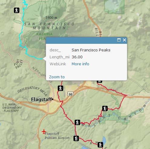
19 There is a free demo of the Arizona Trail App for everyone to enjoy, which includes the 36-mile San Francisco Peaks Passage of the Arizona Trail near Flagstaff. The entire 800-mile Arizona Trail App is available as an in-app purchase for only $
20 Get out and enjoy the trail The ATA is always in need of volunteers to help with many aspects of the Arizona Trail from trail work (maintaining/rerouting tread) to working with Seeds of Stewardship and building relationships with trail towns called Gateway Communities contact or visit for more details Aaron Seifert, GISP GIS Director for the Arizona Trail Association Cell
Trail Information. New Maps in Multiple Formats. In 2017, the Pacific Northwest Trail Association developed an entirely new mapset for
 2017 Trail Information New Maps in Multiple Formats In 2017, the Pacific Northwest Trail Association developed an entirely new mapset for the PNNST. The centerline data was revised to reflect the latest
Pacific Northwest National Scenic Trail. USDA-Forest Service Pacific Northwest and Northern Regions April 2014
 Pacific Northwest National Scenic Trail USDA-Forest Service Pacific Northwest and Northern Regions April 2014 Today s trip 1. What is a National Scenic Trail 2. About the Pacific Northwest Trail 3. Planning
Mission. Purpose. Idaho Trails Association promotes the continued enjoyment of Idaho s hiking trails.
 The Idaho Trails Association (ITA) is a non-profit 501(c)3. Mission Idaho Trails Association promotes the continued enjoyment of Idaho s hiking trails. Purpose To facilitate the active enjoyment of Idaho
SEGMENT ASSESSMENT REPORT
 2017 SEGMENT ASSESSMENT REPORT SEGMENT 3: MT ROSE / TAHOE MEADOWS TO SPOONER SUMMIT REPORT SUMMARY This report is a compilation of information collected on the Tahoe Rim Trail during assessments performed
Rocky Mountain National Park Hiking Map By Trails Illustrated Maps
 Rocky Mountain National Park Hiking Map By Trails Illustrated Maps 10 Great Hikes for Families with Kids in Estes Park, Colorado - Choose from plenty of great family hikes in Rocky Mountain National park.
Creating a User-Driven Long-Distance OHV Trail Through Partnering
 Joseph Raffaele Outdoor Recreation Planner U.S. Bureau of Land Management Yuma, Arizona Creating a User-Driven Long-Distance OHV Trail Through Partnering BLM is a multiple-use land management agency within
Logo Department Name Agency Organization Organization Address Information 5700 North Sabino Canyon Road
 Logo Department Name Agency Organization Organization Address Information United States Forest Coronado National Forest 5700 North Sabino Canyon Road Department of Service Santa Catalina Ranger District
Road Trip Map Book. America s Most Scenic Road Trip
 America s Most Scenic Road Trip Road Trip Map Book A Publication of the US Route Appreciation Society Maps & Photographs by James Cowlin Introduction by Wayne Ranney 2018-2019 Edition Featuring interactive
Course Description. Oregon Pacific Crest Trail Backpacking for Adults
 Overview This backpacking course is designed to prepare and train you to tackle the Pacific Crest Trail (PCT) and other long distance hiking trails on your own. It is also designed so that if you desire,
THE PANTHER S ROAR PO BOX 51 CASHIERS, NC (828) 269-HIKE
 269-HIKE") Friends of Panthertown The Panther s Roar Panthertown Valley WNC THE PANTHER S ROAR PO BOX 51 CASHIERS, NC 28717 WWW.PANTHERTOWN.ORG (828) 269-HIKE Friends of Panthertown News Celebrating our 12th year
Friends of Panthertown The Panther s Roar Panthertown Valley WNC THE PANTHER S ROAR PO BOX 51 CASHIERS, NC 28717 WWW.PANTHERTOWN.ORG (828) 269-HIKE Friends of Panthertown News Celebrating our 12th year
Flat Tops North (National Geographic Trails Illustrated Map) By National Geographic Maps - Trails Illustrated
 By National Geographic Maps - Trails Illustrated") Flat Tops North (National Geographic Trails Illustrated Map) By National Geographic Maps - Trails Illustrated If you are looking for the ebook by National Geographic Maps - Trails Illustrated Flat Tops
Flat Tops North (National Geographic Trails Illustrated Map) By National Geographic Maps - Trails Illustrated If you are looking for the ebook by National Geographic Maps - Trails Illustrated Flat Tops
Arizona Game and Fish Department Report for Inventory of Motorized Dispersed Campsites on the Tonto National Forest
 Arizona Game and Fish Department Report for Inventory of Motorized Dispersed Campsites on the Tonto National Forest Prepared By: ' _2-_.J_.., +-- / S IS Specialist II, Arizona Game and Fish Dep rtment
USGS Efforts to Consolidate Geospatial Data in the Federal Government
 ++ 1 USGS Efforts to Consolidate Geospatial Data in the Federal Government An overview of USGS trails collaborations and updates. Date 5/31/2017 Greg Matthews + Introduction USGS The following slides provide
Campsite Guide SWITZERLAND (with GPS Data And DETAILED MAPS) By m lab
 By m lab") Campsite Guide SWITZERLAND (with GPS Data And DETAILED MAPS) By m lab If you are searching for the book Campsite Guide SWITZERLAND (with GPS Data and DETAILED MAPS) by m lab in pdf form, then you have
Campsite Guide SWITZERLAND (with GPS Data And DETAILED MAPS) By m lab If you are searching for the book Campsite Guide SWITZERLAND (with GPS Data and DETAILED MAPS) by m lab in pdf form, then you have
5+ BEST DIY BACKPACKING HAMMOCK PLANS FREE PDF VIDEO DOWNLOAD
 PDF 5+ BEST DIY BACKPACKING HAMMOCK PLANS FREE PDF VIDEO DOWNLOAD BACKPACKING CHECKLIST OUTDOORGEARLAB 1 / 5 2 / 5 3 / 5 backpacking nevada pdf Backpacking Hammock Plans. The Best Backpacking Hammock Plans
Bradshaw Trails Series
 Bradshaw Trails Series Curtis James Troop 7014 Curtis.James@erau.edu My Motto: Never get lost! Hiking Rules Bradshaw Hiking Patch Series Hiking Tools Hiking Rules Hiking Merit Badge* Take five 10-mile
Jeppesen Total Navigation Solution
 Jeppesen Total Navigation Solution Executive summary Do more with less. It s a challenge we all face, and it s the reality of military operations. Jeppesen s Total Navigation Solution (TNS) gives you enterprise,
Susitna-Watana Hydroelectric Project (FERC No ) Recreation Resources Study Study Plan Section Study Implementation Report
 Recreation Resources Study Study Plan Section Study Implementation Report") (FERC No. 14241) Recreation Resources Study Study Plan Section 12.5 2014 Study Implementation Report Prepared for Prepared by AECOM November 2015 TABLE OF CONTENTS 1. Introduction... 4 2. Study Objectives...
(FERC No. 14241) Recreation Resources Study Study Plan Section 12.5 2014 Study Implementation Report Prepared for Prepared by AECOM November 2015 TABLE OF CONTENTS 1. Introduction... 4 2. Study Objectives...
Bob Marshall Wilderness Foundation
 About the Bob Marshall Wilderness Complex Considered by many to be the crown jewel of the wilderness preservation system, the Bob Marshall Wilderness Complex located in Northwestern Montana, is the third
USFS Minimum Protocol for Social Trail Monitoring in Wilderness Ashley D Antonio and Troy Hall Oregon State University November, 2016
 USFS Minimum Protocol for Social Trail Monitoring in Wilderness Ashley D Antonio and Troy Hall Oregon State University November, 2016 1 Table of Contents 1. INTRODUCTION... 4 2. DATA COLLECTION... 4 a.
My Check-in APPLICATION USER GUIDE
 My Check-in APPLICATION USER GUIDE Contents Overview 3 System Requirements 3 Enabling My Check-in 4 Homescreen and Special Instructions Signing In Home Screen and Phone Numbers Special Instructions Checking
Sharetrails.Org/BRC 30 th Anniversary Celebration Motorcycle Guide to Needles Trails. Route book brought to you by
 Sharetrails.Org/BRC 30 th Anniversary Celebration Motorcycle Guide to Needles Trails Route book brought to you by Welcome to our 30 th Anniversary Celebration! Thank you for coming and we hope that you
March 14, SUBJECT: Public input to the Bureau of Land Management, Gunnison Field Office, Travel Management Plan
 March 14, 2019 Delivered via email to ewaters@blm.gov Elijah Waters Field Manager BLM Gunnison Field Office Gunnison, CO 81230 SUBJECT: Public input to the Bureau of Land Management, Gunnison Field Office,
PublicVue TM Flight Tracking System. Quick-Start Guide
 PublicVue TM Flight Tracking System Quick-Start Guide DISCLAIMER Data from the PublicVue TM Flight Tracking System (FTS) is being provided to the community as an informational tool, designed to increase
National Capital Mountain Bike Association. Municipal Building Retrofit Program
 National Capital Mountain Bike Association Municipal Building Retrofit Program Our Mission To promote sustainable trail access for Mountain Bike riders, and to maintain the trails on which we ride. We
Appalachian Trail Community
 Harpers Ferry, West Virginia Appalachian Trail Community A Designation Program of the Appalachian Trail Conservancy The Appalachian Trail Conservancy (ATC) mission is to preserve and manage the Appalachian
Sandia Mountain Hiking Guide By Mike Coltrin
 Sandia Mountain Hiking Guide By Mike Coltrin Browse and Read Sandia Mountain Hiking Guide Sandia Mountain Hiking Guide That's it, a book to wait for in this month. Even you have wanted for long time for
Pacific Crest Trail: Southern California By Jeffrey P. Schaffer, Ben Schirfin READ ONLINE
 Pacific Crest Trail: Southern California By Jeffrey P. Schaffer, Ben Schirfin READ ONLINE If searched for a ebook by Jeffrey P. Schaffer, Ben Schirfin Pacific Crest Trail: Southern California in pdf format,
MYOB EXO OnTheGo. Release Notes 1.2
 MYOB EXO OnTheGo Release Notes 1.2 Contents Introduction 1 What s New in this Release?... 1 Installation 2 Pre-Install Requirements... 2 Installing the EXO API... 2 Installing EXO OnTheGo... 2 New Features
A GIS Analysis of Probable High Recreation Use Areas in Three Sisters Wilderness Deschutes and Willamette National Forests
 Lindsey Kiesz Geo 565 Term Project 3/15/2010 A GIS Analysis of Probable High Recreation Use Areas in Three Sisters Wilderness Deschutes and Willamette National Forests Introduction The Three Sisters Wilderness
Map/Compass/GPS for the Lightweight Backpacker. Presented By Dennis Horwitz Micronor Inc.
 Map/Compass/GPS for the Lightweight Backpacker Presented By Dennis Horwitz Micronor Inc. dennis@micronor.com DRAFT 6/24/2013 Principles of Lightweight Backpacking 1. Take enough gear to be safe, comfortable
AA Street By Street Z-map Leeds (AA Street By Street Z-Map)
") AA Street By Street Z-map Leeds (AA Street By Street Z-Map) If you are searched for a book AA Street by Street Z-map Leeds (AA Street by Street Z-Map) in pdf form, in that case you come on to faithful
AA Street By Street Z-map Leeds (AA Street By Street Z-Map) If you are searched for a book AA Street by Street Z-map Leeds (AA Street by Street Z-Map) in pdf form, in that case you come on to faithful
Waukee Trailhead Public Art and Amenities Project
 Waukee - Trailhead Public Art and Amenities Project Sponsor Waukee Project Title Waukee Trailhead Public Art and Amenities Project Termini Description ( i.e. Park Avenue to 19th Street) NE Intersection
Garmin Pilot. Plan. File. Fly.
 Garmin Pilot Plan. File. Fly. Garmin Pilot Comprehensive Suite of Aviation Tools VFR Sectionals IFR High and Low En-route charts Dynamic Layer Maps Aviation Weather AOPA Airport Directory Flight Plan Filing
Colorado Mountain Club 2015 Stewardship Team Program Accomplishments
 Summary In 2015, CMC launched a new Stewardship Team program and hired a crew of young (25 and under), natural resource professionals to increase capacity of public land management agencies and coordinate
Hike and Backpack with the Mountaineers!
 Hike and Backpack with the Mountaineers! 2017 Mountaineers Hiking Programs 2017 Mountaineers Hiking Programs Free Hikes and Backpacks Are Available Year-round Every season of the year the Mountaineers
Blueways: Rivers, lakes, or streams with public access for recreation that includes fishing, nature observation, and opportunities for boating.
 Parks, Open Space and Trails PRINCE WILLIAM COUNTY 2008 COMPREHENSIVE PLAN TRAILS PLAN CONTENTS The components of the trails plan are: Intent Definitions Goals, Policies, and Action Strategies Trails Map
PROPOSED PARK ALTERNATIVES
 8 Chimne y Rock State Park M a ster Pl an 2011 PROPOSED PARK ALTERNATIVES Introduction Three different park development concepts were prepared and presented to the citizens of North Carolina through a
Mt. Hood [Map Pack Bundle] (National Geographic Trails Illustrated Map) By National Geographic Maps - Trails Illustrated READ ONLINE
![Mt. Hood [Map Pack Bundle] (National Geographic Trails Illustrated Map) By National Geographic Maps - Trails Illustrated READ ONLINE](/thumbs/85/92056945.jpg "Mt. Hood [Map Pack Bundle] (National Geographic Trails Illustrated Map) By National Geographic Maps - Trails Illustrated READ ONLINE") Mt. Hood [Map Pack Bundle] (National Geographic Trails Illustrated Map) By National Geographic Maps - Trails Illustrated READ ONLINE If you are looking for a book by National Geographic Maps - Trails Illustrated
Mt. Hood [Map Pack Bundle] (National Geographic Trails Illustrated Map) By National Geographic Maps - Trails Illustrated READ ONLINE If you are looking for a book by National Geographic Maps - Trails Illustrated
Mobile FliteDeck VFR Version Release Notes
 Mobile FliteDeck VFR Version 2.2.1 - Release Notes This document supports version 2.2.1 (build 10281) of Mobile FliteDeck VFR for ios. The minimum operating system requirement for this release is ios10.
Federal GIS Conference February 10 11, 2014 Washington DC. ArcGIS for Aviation. David Wickliffe
 Federal GIS Conference 2014 February 10 11, 2014 Washington DC ArcGIS for Aviation David Wickliffe What is ArcGIS for Aviation? Part of a complete system for managing data, products, workflows, and quality
Trans Canada Trail Signage Guidelines MADE BY CANADA
 Trans Canada Trail Signage Guidelines MADE BY CANADA Mission: We will promote and assist in the development and use of the Trans Canada Trail by supporting success at the local level in the creation of
The Grand Canyon (Arizona Highways Special Scenic Collections) By Arizona Highways Contributors
 By Arizona Highways Contributors") The Grand Canyon (Arizona Highways Special Scenic Collections) By Arizona Highways Contributors If you are looking for the book The Grand Canyon (Arizona Highways Special Scenic Collections) by Arizona
The Grand Canyon (Arizona Highways Special Scenic Collections) By Arizona Highways Contributors If you are looking for the book The Grand Canyon (Arizona Highways Special Scenic Collections) by Arizona
Mobile FliteDeck VFR Release Notes
 Mobile FliteDeck VFR Release Notes This document supports version 2.3.0 (build 2.3.0.10334) of Mobile FliteDeck VFR for ios. The minimum operating system requirement for this release is ios10. On the date
Superintendent David Uberuaga June 27, 2011 Grand Canyon National Park P.O. Box 129 Grand Canyon, AZ 86023
 Superintendent David Uberuaga June 27, 2011 Grand Canyon National Park P.O. Box 129 Grand Canyon, AZ 86023 Dear Superintendent Uberuaga, Thank you for the opportunity to provide scoping comments on Grand
Kym's Backpacker's Topographic Map Of John Muir Trail Section Of Pacific Crest Trail, Yosemite, Merced Peak, California, Usa: Vernal Nevada Falls,
 Kym's Backpacker's Topographic Map Of John Muir Trail Section Of Pacific Crest Trail, Yosemite, Merced Peak, California, Usa: Vernal Nevada Falls, Hiking In Yosemite, Glacier Point, Mirror Lake, Inspi
top rated rocky mountain pdf Rocky Mountain Cycle Bike Touring and Cycling Adventure Rocky Mountain Maps NPMaps.com - just free maps, period.
 DOWNLOAD OR READ : TOP RATED ROCKY MOUNTAIN ADVENTURES INCLUDES COLORADO IDAHO MONTANA NEW MEXICO UTAH WYOMING ALBERTA BRITISH COLUMBIA SASKATCHEWAN YUKON TERRITORIES TOP RATED OUTDOOR SERIES PDF EBOOK
Continental Divide National Scenic Trail Legislative History and Planning Guidance
 Continental Divide National Scenic Trail Legislative History and Planning Guidance Legislation, Policy, and Direction Regarding National Scenic Trails The National Trails System Act, P.L. 90-543, was passed
GPS Training
 Garmin Ski Bundles - Garmin with Mountain Dynamics SnowRanger Maps Several years ago Garmin and Mountain Dynamics launched SnowRanger maps for both North America & Europe that included information regarding
Partnership for the National Trails System
 Partnership for the National Trails System Commemorating the 50th Anniversary of the National Trails System Act: Tips, Tuesday, November 2nd at 3PM EST Chelsea Bodamer Kelly Snavely Outreach and Youth
TRAVEL AGENT NEW USER MANUAL
 TRAVEL AGENT NEW USER MANUAL WE LC O M E TO HO M EP O R T TR AVE L AGE NT POR TA L Your one-stop destination for all Royal Caribbean s tools of the trade. WHY SHO ULD I SIGN- U P FO R HO M E PO R T? HomePort
September 14, Comments of the Colorado Trail Foundation On the USFS Scoping Notice of August 13, 2010 RE: the relocation of the CDNST/CT Page 1
 THE COLORADO TRAIL FOUNDATION Comments on the U.S. Forest Service Scoping Notice of August 13, 2010 Regarding the Relocation of THE COLORADO TRAIL AND CONTINENTAL DIVIDE NATIONAL SCENIC TRAIL From La Garita
MOAB peopleforbikes.org/e-bikes
 emtb ADVENTURE MAPS MOAB peopleforbikes.org/e-bikes OVERVIEW Moab, Utah is a world-class mountain bike destination known for its vast, red sandstone landscapes nestled below the rising peaks of the La
Pacific Crest Trail: Northern California By Jeffrey P. Schaffer READ ONLINE
 Pacific Crest Trail: Northern California By Jeffrey P. Schaffer READ ONLINE The Pacific Crest National Scenic Trail (PCT) is a 2,600-mile. While the PCT portion of this celebrated Northern California landmark
NASCIO 2015 State IT Recognition Awards
 NASCIO 2015 State IT Recognition Awards Title: Camp Lawton Augmented Reality Category: Digital Government Government to Citizen Contact: Mr. John Martin Chief Information Officer Department of Natural
Unstable Slope Management Program for FLMAs. Presented by: Douglas A. Anderson, LG, LEG FHWA - WFL - Engineering Geologist
 Unstable Slope Management Program for FLMAs Presented by: Douglas A. Anderson, LG, LEG FHWA - WFL - Engineering Geologist FLMA Stakeholders Project Conducted by: Types of Unstable Slopes Goals of USMP
Everglades National Park (National Geographic Trails Illustrated Map) By National Geographic Maps - Trails Illustrated
 By National Geographic Maps - Trails Illustrated") Everglades National Park (National Geographic Trails Illustrated Map) By National Geographic Maps - Trails Illustrated If you are searched for a book by National Geographic Maps - Trails Illustrated Everglades
Everglades National Park (National Geographic Trails Illustrated Map) By National Geographic Maps - Trails Illustrated If you are searched for a book by National Geographic Maps - Trails Illustrated Everglades
In-flight Wi-Fi & Entertainment INSTRUCTIONAL GUIDE
 In-flight Wi-Fi & Entertainment INSTRUCTIONAL GUIDE In-flight Wi-Fi Player Support About Availability & coverage How to connect Homepage In-flight Entertainment Device setup How to watch Troubleshooting
AEROVISION AUGMENTED REALITY AIRPORTS IN 3D Young Professionals Innovation Competition Daniel Schoenberg, RS&H Jill Geboy, Jacobs Engineering Daniel
 AUGMENTED REALITY AIRPORTS IN 3D Young Professionals Innovation Competition Daniel Schoenberg, RS&H Jill Geboy, Jacobs Engineering Daniel Pruim, Horry County Department of Airports Challenges Explore Innovate
PELICAN ISLAND COMMUNITY PARTNERSHIP SCHOOL. Bylaws
 PELICAN ISLAND COMMUNITY PARTNERSHIP SCHOOL Bylaws Article I. Name A. The name of this organization shall be Pelican Island Elementary, A Community Partnership School. B. The designated service area shall
The next generation of in-flight, real-time 3-D moving maps. Airshow 4000 MOVING MAPS
 The next generation of in-flight, real-time 3-D moving maps. Airshow 4000 MOVING MAPS Stay engaged and aware in the air. In today s world, things happen faster than ever. You can t afford to be out of
The Appalachian Trail Hiker: Trail-Proven Advice For Hikes Of Any Length (None) By Frank Logue, Victoria Logue
 By Frank Logue, Victoria Logue") The Appalachian Trail Hiker: Trail-Proven Advice For Hikes Of Any Length (None) By Frank Logue, Victoria Logue The Appalachian Trail Hiker: Trail-Proven Advice for Hikes of Any Length (None) [Victoria
The Appalachian Trail Hiker: Trail-Proven Advice For Hikes Of Any Length (None) By Frank Logue, Victoria Logue The Appalachian Trail Hiker: Trail-Proven Advice for Hikes of Any Length (None) [Victoria
Table of Contents. page 3 Long term Goals Project Scope Project History. 4 User Groups Defined Trail Representative Committee. 5 Trail Users Breakdown
 Launched April 27th, 2010 1 Table of Contents page 3 Long term Goals Project Scope Project History 4 User Groups Defined Trail Representative Committee 5 Trail Users Breakdown 13 Trail Users Desires 16
When One Size Doesn t Fit All Building Volunteers with a Spectrum of Opportunity
 November 2013 PNTS When One Size Doesn t Fit All Building Volunteers with a Spectrum of Opportunity Claire Miller City of Scottsdale McDowell Sonoran Preserve The Preserve is Born 1991 Citizens form the
Wishlist Plug-in USER GUIDE
 support@simicart.com Phone: 084.4.8585.4587 Wishlist Plug-in USER GUIDE Table of Contents 1. INTRODUCTION... 3 2. HOW TO INSTALL... 4 3. HOW TO CONFIGURE... 5 4. HOW TO USE WISHLIST PLUG-IN... 6 Wishlist
2016 Trails Maintenance and Operating Costs
 2016 Trails Maintenance and Operating Costs Motorized Trails Maintenance for motorized trails comes from vehicle registration fees and a portion of the federal Recreation Trails Program (RTP) funds. The
Concur Travel-Frequently Asked Questions
 Concur Travel-Frequently Asked Questions Click Links to Navigate User & Profile Assistance First Time Logging into Concur Travel & Expense Forgot Password System is slow Smartphone Access Air Car Hotel-Navigational
The Who, What, When How of QR CODES. Jim Lambert NW PATINS Regional Site Coordinator
 The Who, What, When How of QR CODES Jim Lambert NW PATINS Regional Site Coordinator nwpatins@ciesc.k12.in.us The PATINS Project is a state-wide technical assistance network for the provision of assistive/accessible
Hermosa Area Preservation The Colorado Trail Foundation 4/11/2008
 Hermosa Area Preservation The Colorado Trail Foundation 4/11/2008 Legend d o Tr ail NPA - National Protection Area ra NCA - National Conservation Area o e C Th The Colorado Trail lo FS inventoried Roadless
LOCAL PLAN FOR THE MANAGEMENT OF THE APPALACHIAN TRAIL IN MAINE. (GRAFTON NOTCH TO KATAHDIN) 1 January 2013 (Revised 5 February 2014)
 1 January 2013 (Revised 5 February 2014)") LOCAL PLAN FOR THE MANAGEMENT OF THE APPALACHIAN TRAIL IN MAINE (GRAFTON NOTCH TO KATAHDIN) 1 January 2013 (Revised 5 February 2014) The Appalachian Trail is a way, continuous from Katahdin in Maine to
LOCAL PLAN FOR THE MANAGEMENT OF THE APPALACHIAN TRAIL IN MAINE (GRAFTON NOTCH TO KATAHDIN) 1 January 2013 (Revised 5 February 2014) The Appalachian Trail is a way, continuous from Katahdin in Maine to
Smart Commute Tool User Guide
 Smart Commute Tool User Guide The Smart Commute tool is a trip planning tool that allows users to explore commute options, match trips with others and track personal impact (trips logged, distance travelled,
If searching for the ebook Namibia Touring Map in pdf format, in that case you come on to right website. We present the complete edition of this book
 Namibia Touring Map If searching for the ebook Namibia Touring Map in pdf format, in that case you come on to right website. We present the complete edition of this book in DjVu, txt, epub, PDF, doc formats.
APPENDIX G - ARIZONA TRAIL RELOCATION ANALYSIS
 APPENDIX G - ARIZONA TRAIL RELOCATION ANALYSIS TABLE OF CONTENTS 1.0 INTRODUCTION... 1 2.0 MANAGEMENT FRAMEWORK... 1 3.0 EXISTING TRAIL DESCRIPTION... 3 4.0 EVALUATION PROCESS AND CRITERIA... 4 5.0 ALTERNATIVE
December 3, Joan Dupes Administrative Asst
 The Conservation and Natural Resources Advisory Council s Review and Recommendations Regarding DCNR s Role and Responsibilities with Trail Maintenance in Pennsylvania December 3, 2008 Clifford C. David,
Coast to Crest Trail Corridor Hike
 Coast to Crest Trail Corridor Hike Jim Cunningham, Poway City Council member and Board Chair of the San Dieguito River Park in 2013 has embarked on a project to hike the entire 70-mile San Dieguito River
Click the Profile link to review and update your profile. You must save your profile before you first attempt to book a trip. TOP
 FAQ Concur Travel Documentation User & Profile Assistance First Time Logging into Concur Travel & Expense Forgot Password System is slow Smartphone Access Air Car Hotel-Navigational Assistance Air-Search
The Frank Church River of No Return Wilderness
 ALLIANCE FOR WILDERNESS EDUCATION AND STEWARDSHIP PO Box 2667, Bellingham, WA 98227-2667 Tele: 360-927-1804 Fax: 360-527-9679 bradt@wildernessalliance.org www.wildernessalliance.org STEWARDS OF AMERICA
Fly at the speed of ingenuity on your Learjet 85
 rockwell collins Pro Line Fusion Avionics Fly at the speed of ingenuity on your Learjet 85 Image courtesy of Bombardier. Experience the most advanced avionics system ever offered on a mid-size jet. Achieve
S-Series Hotel App User Guide
 S-Series Hotel App User Guide Version 1.2 Date: April 10, 2017 Yeastar Information Technology Co. Ltd. 1 Contents Introduction... 3 About This Guide... 3 Installing and Activating Hotel App... 4 Installing
BACKSTORY & MMBA RECOMMENDATIONS
 URGENT!! COMMENT PERIOD ENDS MONDAY, MARCH 5 TH, 5PM!! MONTANA MOUNTAIN BICYCLE ALLIANCE RECOMMENDED COMMENTS ON CUSTER GALLATIN FOREST PLAN REVISION, Proposed Actions WINTER 2018 The CGNF Forest Plan
SMART WATER FOR LONG DISTANCE HIKERS
 SMART WATER FOR LONG DISTANCE HIKERS Pacific Crest Trail Water Resources IMAGINE IOT PROTOTYPE CHALLENGE STORY SUMMARY The Pacific Crest Trail (PCT) needs a solution to monitor the water sources along
FY19 Colorado Tourism Office Marketing Matching Grant Recipients
 $25,000 Colorado Campground and Lodging Owners Association A marketing plan centered on the Camp Colorado Guide, and expanding the use of digital marketing and social media channels in order to inspire
SMART FLIGHT SCHEDULING
 SMART FLIGHT SCHEDULING 360 Coverage from Initial Trip Requests to Post-Flight Reporting Master your flight scheduling with FltLogic, the only scheduling program that integrates with FltPlan.com. FltLogic
FlyXC.Tools. Quick Start Guide. A short introduction to FlyXC.Tools
 FlyXC.Tools Quick Start Guide A short introduction to FlyXC.Tools Olivier Gosselet & Wim Verhoeve LAST UPDATE: 10 MARCH 2017 Contents Disclaimer... 1 Introduction... 1 Airspace classification... 2 Login...
2014 World Trail Conference. Developing And Administering Cross Boundary Trails. Laura Belleville Director of Conservation
 2014 World Trail Conference Developing And Administering Cross Boundary Trails Laura Belleville Director of Conservation Appalachian Trail Conservancy- Non-profit partner for the Trail Overview A.T. History
Non-motorized Trail Plan & Proposal. August 8, 2014
 Town of Star Valley Ranch, Wyoming and the Star Valley Ranch Association in partnership with the USDA Forest Service, Bridger-Teton National Forest, Greys River Ranger District Non-motorized Trail Plan
HEADQUARTERS WEST LTD. CATTLE RANCHES HORSE PROPERTIES RURAL REAL ESTATE
 Aravaipa Creek Flowing Through the Property Offered for sale exclusively by: Sandy Ruppel Headquarters West, Ltd. PO BOX 542 Sonoita, AZ 85637 Phone (520) 444-1745 sandy@headquarterswest.com www.headquarterswest.com
Fire and Forestry in Oxbow Regional Park, GIS and GPS Implementation
 Fire and Forestry in Oxbow Regional Park, GIS and GPS Implementation Brian Handy, Karen Sexton, Robert Pierce GIS and GPS implementation at Oxbow Regional Park, Oregon, in the preparation for fire danger
South West Contact Centre Awards 2016 Support Team of the Year. Dealer MI Team
 South West Contact Centre Awards 2016 Support Team of the Year Dealer MI Team Who We Are Motability Operations is a not-for-profit company that runs the Motability car scheme the largest fleet operator
Trail Assessment Report
 Trail Assessment Report Trail Options for the Bear Creek Canyon located in Pikes Peak Ranger District, Pike National Forest and on Colorado Springs Utility Lands Due to the presence of a unique species
Melanie. Persona. Hotel Manager. I need to make sure the hotel is ran efficiently and provides the services to make our guests comfortable.
 Story A hotel manager is looking for an easy to use tool that allows them to efficiently manage and be a proactive guest services organization; while providing a simple way for guests to make the requests.
CONNECT UP! Your Flight Path to the Connected Aircraft. In-Flight Internet Onboard Entertainment Flight Operations
 CONNECT UP! Your Flight Path to the Connected Aircraft In-Flight Internet Onboard Entertainment Flight Operations YOUR FLIGHT PATH TO THE CONNECTED AIRCRAFT Leading airlines depend on Viasat to deliver
Neighborhood Leaders Group Strategic Plan. Neighborhood Leaders Group STRATEGIC PLAN
 Neighborhood Leaders Group Strategic Plan Neighborhood Leaders Group STRATEGIC PLAN 1 GOAL ONE: Foster Effective Communications between Communities and Government 1. Development of a NLG website within
Greetings to all Sunrise Trail Coalition Members!
 Sunrise Trail Coalition PO Box 113 Franklin, ME 04634 www.sunrisetrail.org Board of Directors Stephen Rees, President Ian Staub, Treasurer Carol Cuddy, Membership Raymond Archer Bill Ceckler Polly Ceckler
AGENDA BILL. David Wilbrecht, Town Manager Stuart Brown, Recreation Manager
 AGENDA BILL Agenda Item I I February 1, 2012 File No. (ZiZ~. ~ -(O-- to Subject: Resolution to establish and formalize a high level of interagency cooperation with the USDA Inyo National Forest to plan,
Appalachian Trail Sustainability Research Study
 Appalachian Trail Sustainability Research Study Appalachian National Scenic Trail 2,175 mile footpath from Maine to Georgia Crosses 14 states, 6 NPS units, and 8 National Forests, Managed by the NPS A.T.
Tribal Agritourism Marketing Tools, Part 2: Using NativeAmerica.travel to promote tourism and your agribusiness products
 Tribal Agritourism Marketing Tools, Part 2: Using NativeAmerica.travel to promote tourism and your agribusiness products THANK YOU FOR JOINING US! THE WEBINAR WILL BEGIN SHORTLY. Webinar Management Participants
DOWNLOAD OR READ : UTAH NATIONAL PARKS MAP PACK BUNDLE ADVENTURE MAP PDF EBOOK EPUB MOBI
 DOWNLOAD OR READ : UTAH NATIONAL PARKS MAP PACK BUNDLE ADVENTURE MAP PDF EBOOK EPUB MOBI Page 1 Page 2 utah national parks map pack bundle adventure map utah national parks map pdf utah national parks
GPS For VFR: A Practical GPS Guide For VFR Pilots By Mike Meadows
 GPS For VFR: A Practical GPS Guide For VFR Pilots By Mike Meadows If you are searching for a book by Mike Meadows GPS for VFR: A practical GPS guide for VFR pilots in pdf format, then you have come on
2018 Media Kit. Arizona. The AAA brand influences readership & buying habits New name Same audience
 Arizona 2018 Media Kit The AAA brand influences readership & buying habits New name Same audience AAA is one of the most recognized brands in the world. Now you can put that power to work for you by going