Salt River Allotments Vegetative Management EIS Draft Recreation Affected Environment Report Don R. Sullivan November 6, 2012
|
|
|
- Clifton Simmons
- 5 years ago
- Views:
Transcription
1 Salt River Allotments Vegetative Management EIS Draft Recreation Affected Environment Report Don R. Sullivan November 6, 2012 Introduction The area surrounding the Salt River Canyon, the Salt River Canyon Wilderness, and the Sierra Ancha Wilderness, offer recreation settings that are scarce and unique in the arid southwest. Perennial water that supports vegetation and wildlife, and a remote, wild, non-motorized setting characterize much of the Salt River Canyon area. The Wild and Scenic River Study Report and Environmental Impact Statement for the Salt River recommended wild designation of 22 miles of the Salt River as a component of the National Wild and Scenic Rivers System. This segment of river, from Lower Corral Canyon to the Highway 288 Bridge, remains eligible for inclusion in the NWSR system. Recreationists come to the Salt River Canyon area for a wide variety of recreation opportunities including whitewater rafting, kayaking, canoeing, swimming, fishing, hiking, camping, horseback riding, mountain biking, picnicking, wildlife viewing, hunting, target shooting, Off-Highway Vehicle (OHV) use, and scenic driving. Additional characteristics that add value to this recreation setting include challenging river rapids, spectacular scenery, dramatic geology, natural salt deposits, archaeological sites, lush stream and river vegetation, and perennial side streams. The 32,100 acres of land that comprise the Salt River Canyon Wilderness were incorporated into the National Wilderness Preservation System in Although backpackers sometimes access the river by hiking down side creeks, there are no system trails in the Salt River Canyon Wilderness, so recreational access is primarily accomplished by whitewater boating. The 20,850 acres of land that comprise the Sierra Ancha Wilderness were incorporated into the National Wilderness Preservation System in Access to the Sierra Ancha Wilderness is primarily by foot or horseback through one of thirteen trailheads. Recreational River Running The Upper Salt River is an undammed, free-flowing whitewater river. As such, its water level is entirely dependent upon the annual rainfall and snowpack in its basin, located in the White Mountains of Arizona. Water levels can drop below 100 cubic feet per second (cfs) in summer and have risen as high as 143,000 cfs at flood stage. Recreational river running typically occurs in the spring, at water levels ranging between 500 cfs and 10,000 cfs, with some additional use in summer monsoon season.
2 The rafting portion of the Upper Salt River runs 52 miles from the put-in near the Highway 60 Bridge to the take-out at the Highway 288 Bridge. Administratively, this is broken up into three Segments; the 9-mile Salt Banks segment, the 11-mile Gleason segment, and the 32-mile Wilderness segment. The Forest Service co-manages the Upper Salt River with the White Mountain Apache Tribe, whose tribal lands on the north side of the river extend 28.9 miles below the Highway 60 put-in. The Forest Service issues permits to four commercial outfitters for the Upper Salt River. The outfitter s clients are from all over the United States, with the majority coming from the four corners region. These small businesses book half-day, full-day, or overnight trips on the Salt Banks and Gleason segments, or three to five day trips for the entire length of river. Bookings vary yearly with the snowpack and water level. In 2010, a year with normal snowpack, the outfitters sold 8,098 user days (one person on the river for one day), grossing a total of $774,935. From March 1 to May 15 the Forest Service requires a permit for private boaters (people with their own boats who wish to organize their own trips) to boat through the Salt River Canyon Wilderness. Private boaters may pay the $10 application fee to be included in the yearly random drawing for special recreation permits. There are four of these permits available, for trips of up to fifteen people, for each of the 76 days of the permitted season, or 304 available permits. There is a onetime fee of $125 for each permit. In 2010, 1,792 people applied, and 282 permits were issued, to boat through the Salt River Canyon Wilderness, generating $53,170 in permit fees. Private boaters also conduct day and overnight trips on the Salt Banks and Gleason sections where no Forest Service permit is required. Private boater application data shows that boaters come from as far away as Massachusetts and Alaska. Most applicants are from urban areas, and are from the southwest. Sizable populations from the Northwest, California, and Texas also apply. While it is known that, through spending on gas, food, lodging and other items, river recreationists contribute to local jobs and revenue, no study has been conducted to determine the amount of revenue that boaters provide to the communities near the Upper Salt River. Given that almost all of the commercial and private boaters are from outside the Globe/Miami area, it is likely that boating on the Upper Salt River is this local community s largest source of ecotourism. Commercial and private boaters on the Upper Salt River must practice leave no trace camping and have a number of special regulations that they must follow, abbreviated in the table below. These include containing their fires in a firepan so as not to leave a mark on the beach and carrying and using a human waste removal system. Upper Salt River Regulations Abbreviated Regulation Segment CFR Boating permit required March 1 to May 15 Wilderness 36 CFR (a) Must remove human solid waste Salt Banks, Gleason, Wilderness 36 CFR (g)
3 Upper Salt River Regulations Abbreviated Regulation Segment CFR No wheeled vehicles Wilderness 36 CFR (h) Group size of 15 or less Wilderness 36 CFR (f) Group size of 25 or less Salt Banks, Gleason 36 CFR (f) No camping at Walnut Falls Gleason 36 CFR (e) Campfire must be contained in firepan Indigenous plants dead and down only No littering Salt Banks, Gleason, Wilderness 36 CFR (a) Salt Banks, Gleason, Wilderness 36 CFR (t) Salt Banks, Gleason, Wilderness 36 CFR (g) Other Recreational Use Road and trail access is a key factor that determines amount and type of non-riverrunning recreation use along the Upper Salt River Canyon area. OHV use, horseback riding, mountain biking, fishing, swimming, hiking, camping, picnicking, wildlife viewing, bird watching, hunting, target shooting, and scenic driving primarily take place where forest roads and trails provide access. Scenic Driving / Mountain Biking / OHV Use: The area surrounding the Salt River Canyon offers a variety of views of some of the most beautiful scenery in the Southwestern United States. Views range from the pine forests of the Timber Camp and Sierra Ancha Mountains, to Saguaro laden vistas of the Sonoran Desert. Vehicles used for scenic driving vary with the terrain, and range from passenger cars to dirt and mountain bikes. District recreation personnel report that OHV scenic driving is the most common recreational use in the uplands of the analysis area, and is often combined with other recreational uses like hunting, Target shooting, fishing and picnicking. Hunting / Fishing: Hunting and fishing are year-round activities in the analysis area. Not surprisingly, hunting increases in the seasons permitted for taking large game. Fishing on the Upper Salt River is primarily for Catfish and initiates at vehicle access points like Horseshoe Bend and Gleason Flat. Horseback Riding: While much of the horseback riding in the analysis area emanates from the Timber Camp Equestrian Site (see below), the trailheads of the Sierra Ancha Wilderness and forest roads like the Horseshoe Bend Road (FR 219) and the Gleason Flat Road (FR 303) are also launching off points for equestrians. Hiking: Most of the hiking in the analysis area takes place in the Sierra Ancha Wilderness. While there are no trails in, or leading into, the Salt River Canyon Wilderness, people occasionally hike down side canyons like Cherry Creek or Coon Creek. Wildlife Viewing / Bird Watching: Due to its close proximity to the high elevation Mogollon Rim and Sierra Ancha Mountains, and low elevation deserts surrounding the Upper Salt River, there is a great range of available birds and wildlife to view in the area surrounding the Upper Salt River. Much of this activity happens from forest roads in combination with scenic driving.
4 Developed Recreation Areas There are three developed recreation areas in the analysis area; Timber Camp Recreation Area, Jones Water Recreation Area, and Bull Canyon Trailhead. Timber Camp Recreation Area is a heavily used campground located 26 miles east of Globe Arizona on the north side of Highway 60. It is broken into 4 separate sites, all of which are fenced off from the surrounding grazing allotment. Timber Camp Equestrian Site and Brundrett Site 1 are available for use by reservation. Brundrett Site 2 and Timber Camp Day Use Picnic Area are open year-round. o Timber Camp Equestrian Site: With a large parking area to accommodate horse trailers, this site has three corrals, two hitching posts, two manure receptacles, a concrete vault toilet, a fire ring, and a ramada that shelters six picnic tables. o Brundrett Site 1: Brundrett Site 1 has two ramadas (each with six picnic tables) and a fire ring. It has three concrete vault toilets available for use from the fourteen campsites, each with a picnic table and fire ring. o Brundrett Site 2: Brundrett Site 2 has a parking area for large groups and three day use picnic tables. It has a concrete vault toilet available for use from three campsites, each with a picnic table and fire ring. o Timber Camp Day Use Picnic Area: This area has a concrete vault toilet and four picnic tables. With the closure of the state owned rest area along highway 60, this toilet has become the de-facto rest area for travelers between Globe and Show Low Arizona. Jones Water Recreation Area is a moderately used campground 19 miles east of Globe Arizona on the south side of Highway 60. The campground is in a riparian area with perennial water, and is not currently fenced off from the surrounding allotment. It has two concrete vault toilets available for use from the twelve campsites, each with a picnic table and fire ring. Bull Canyon Trailhead is a simple gravel parking lot with a sign designating the trailhead. Recreation/ Wilderness Opportunity Spectrums and Visual Quality Objective The Tonto National Forest Land and Resource Management Plan (LMP) identifies the Recreation Opportunity Spectrum (ROS) class system, and the Wilderness Opportunity Spectrum (WOS) class system categories used on forest lands to help guide development and management in order to provide a variety of recreation and wilderness experiences desired by the public. The ROS spectrum is broken into Semi-Primitive Non-Motorized (SPNM), Semi-Primitive Motorized (SPM), Roaded Natural (RN), Rural (R), and Urban (U) classes. The WOS spectrum is broken into classes I, II, III, and IV. Classes of recreation and wilderness experiences are described in Recreation Appendixes 1 and 2, and shown for the analysis area in Recreation Map 1. The table below shows the number
5 and miles of roads and trails, and the number and percentage of acres of each class, in the analysis area. SR-6 ROS / WOS Acres / Roads / Trails Class Acres Percentage # of Roads Miles Road # Trails Miles Trail SPNM 137, % SPM 72, % RN 63, % R 2,731.99% ROS Total 275, % WOS I 29, % N/A N/A WOS II 11, % N/A N/A WOS III % N/A N/A 2.57 WOS IV 66.15% N/A N/A 2.23 WOS Total 41, % N/A N/A Total % The uplands of the analysis area are primarily a mixture of roaded natural, semi-primitive motorized, and semi-primitive non-motorized recreation opportunities. The Sierra Ancha Wilderness and the Salt River Canyon Wilderness are primarily WOS Classes I and II. Campsites along the Upper Salt River are in semi-primitive motorized in the Salt Banks segment, semi-primitive non-motorized in the Gleason segment, and WOS Opportunity Class II in the Wilderness segment. The LMP assigns a Visual Quality Objective (VQO) for the purpose of maintaining or enhancing the scenic qualities of the Tonto s landscapes. Visual Quality Objective Classes, described in Recreation Appendix 3, represent different degrees of acceptable alterations to national forest landscapes. The LMP directs a VQO of Retention (man s activities are not evident to the casual observer) for the Upper Salt River Management area (LMP) and preservation (provides for ecological changes only) in the Salt River Canyon Wilderness and the Sierra Ancha Wilderness (LRP). River Recreation Resource Conditions The Tonto National Forest Salt River Canyon Wilderness Implementation Plan (SRCWIP) states that a Limits of Acceptable Change (LAC) concept will be used to access acceptable conditions in the Wilderness, establish a program of monitoring conditions, and evaluate management effectiveness and that management of the recreation resource will be consistent with the specified WOS Class. The SRCWIP sets the LAC standards for the Wilderness segment of the Upper Salt River. Similarly, the Tonto National Forest Implementation Plan for the Upper Salt River (IPUSR) sets the LAC standards for the Salt Banks and Gleason segments, consistent with their specified
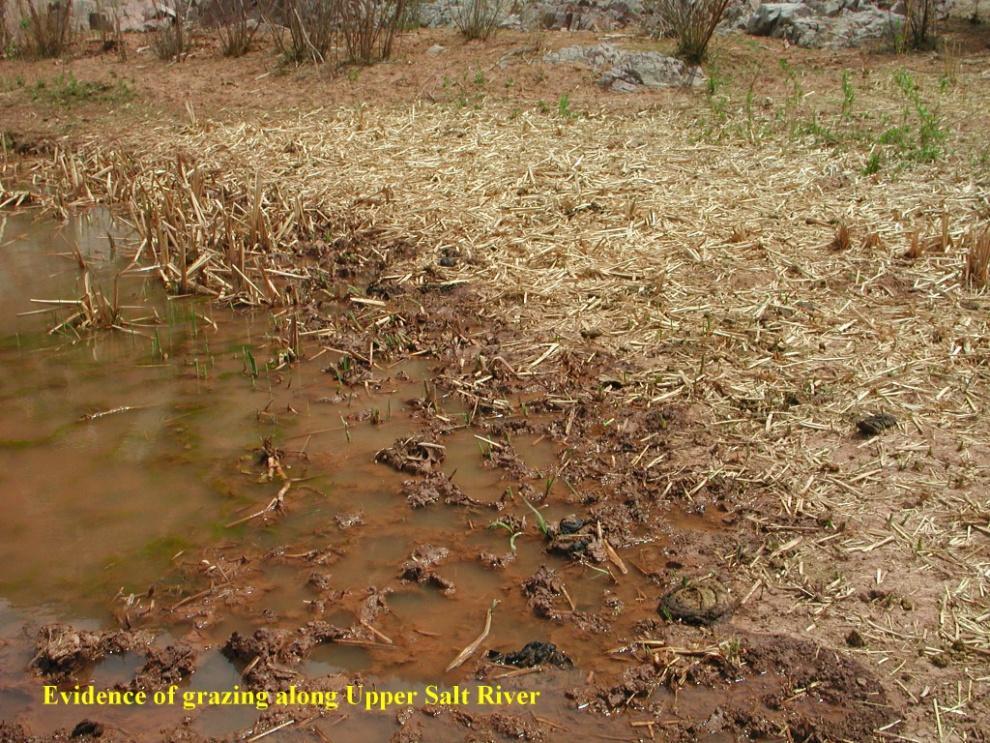
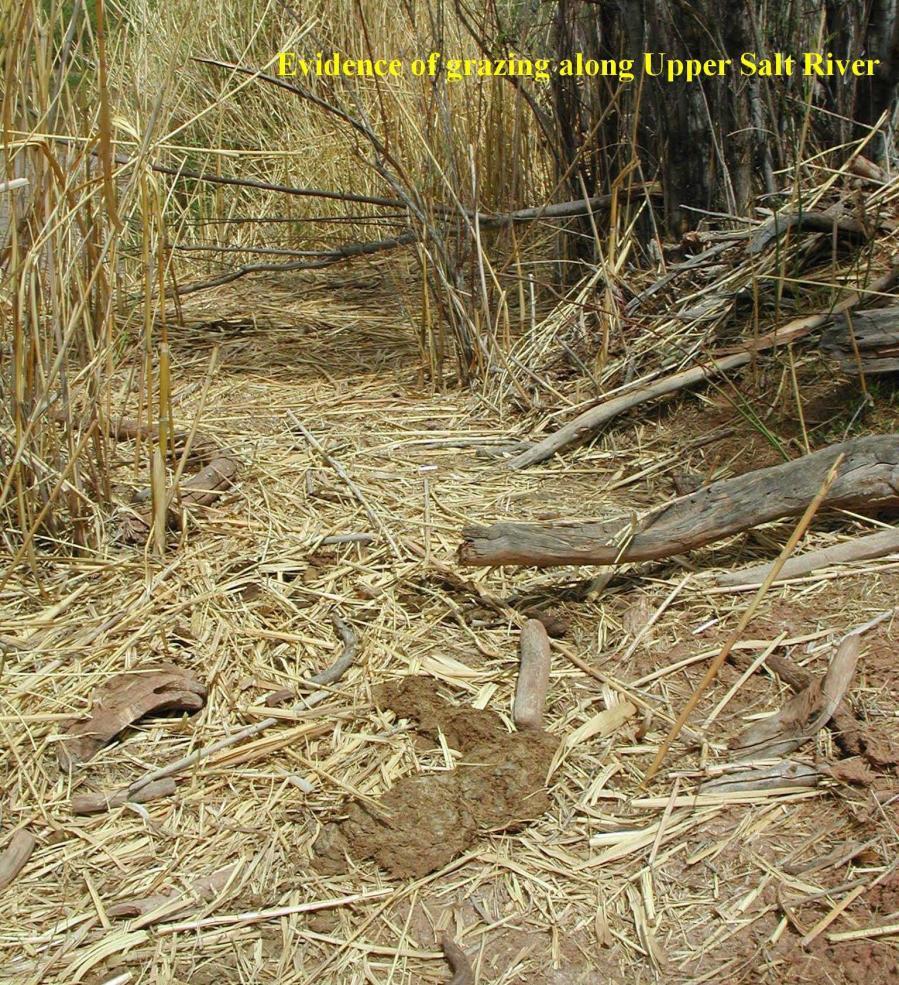
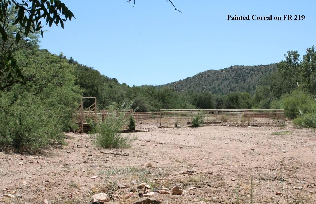
6 ROS classes. Both plans direct management personnel to inventory and evaluate LAC indicators on a continuing basis using the Tonto National Forest Campsite Inventory and Analysis Form, Recreation Appendix 4. Between 1991 and 2011 campsite inventories were conducted in 48 camps in the analysis area in the river corridor of the Upper Salt River Canyon. The inventories show that impacts in the campsites along the river have dropped significantly since the 1990s and, with the exception of the campsites immediately adjacent to vehicle access points at Gleason Flats and Horseshoe Bend, they are well below the established Limits of Acceptable Change (LAC). For instance, campsites in the wilderness inventoried in 1999 had an average overall score of 21, with 67% of the inventoried campsites over the LAC of 19. In 2011 the campsites inventoried in the wilderness had an average overall score of 5, with only.05% of the inventoried campsites over the LAC of 19. Campsites inventoried from 1991 to 1999 had an average score of 20 while those inventoried between 2000 and 2011 had and average score of 8. Impacts to the river corridor and campsites have dropped for a number of reasons including adoption and enforcement of Leave No Trace regulations for forest users and outfitters, the addition of actively patrolling river rangers, and the removal of cattle from the river corridor. There are a number of highly visible range improvements in the Upper Salt River Corridor. Pasture fences extending along the river downstream from Gleason Flat, and across the mouth of the creek at Coon Creek, are in wilderness segment river campsites which are managed as Wilderness Class II, and for a VQO of preservation. The corral in the Gleason Segment at Gleason Flat is at the end of a closed road (FR 303A) in an area managed as semi-primitive non-motorized with a visual quality of retention. Starting at this corral, an illegal user made road was bulldozed by a previous range permittee upstream over a ridge to the east and then across Ash Creek where it too leads to a corral. Upland Recreation Resource Conditions Most of the recreational activity that takes place in the uplands surrounding the Upper Salt River takes place or emanates from forest roads and trails. Depending upon their location and placement in relation to recreational activities, existing and proposed range improvements like piping, water troughs, stock tanks, corrals and fencing may present a visual impact to forest user s recreational experience and the forest s ability to manage recreation opportunities. Range improvements along forest roads with a high degree of recreational usage like Horseshoe Bend Road (FR 219), Gleason Flat Road (FR 303, 303B), Shute Springs Road (FR 223), and Forest Road 897 have numerous range improvements in semi-primitive motorized areas that are highly visible and limit the areas ability to be natural or natural appearing (LMP) (see Rec Photos 1 and 2). Construction and maintenance of range improvements along the former Gleason Flat Road (FR 303A), which had been obliterated and signed closed as planned
7 (IPUSR 19, C-1), have effectively re-opened this road to OHV travel in an area which is designated as semi-primitive non-motorized with a VQO of retention (LMP). Desired Conditions The wilderness act defines wilderness as in contrast with those areas where man and his own works dominate the landscape, is hereby recognized as an area where the earth and its community of life are untrammeled by man where man himself is a visitor who does not remain. An area of wilderness is further defined to mean in this Act an area of undeveloped Federal land retaining its primeval character and influence, without permanent improvements or human habitation, which is protected and managed so as to preserve its natural conditions and which (1) generally appears to have been affected primarily by the forces of nature, with the imprint of man's work substantially unnoticeable; (2) has outstanding opportunities for solitude or a primitive and unconfined type of recreation (WILDERNESS ACT Public Law (16 U.S. C )). The Tonto National Forest Land and Resource Management Plan (LMP), the Salt River Canyon Wilderness Implementation Plan (SRCWIP), and Forest Service Manual 2300, Recreation, Wilderness, and Related Resource Management, specify the following desired conditions: The portion of this management area from near the Highway 288 Bridge upstream to the Fort Apache Reservation boundary was studied by the Forest Service for inclusion in the National Wild and Scenic Rivers System at the direction of the US Congress. Present management emphasis will not preclude future Congressional designation of this river. (LMP) The primary emphasis for the Salt River Canyon Wilderness is the preservation of naturally occurring flora, fauna, aesthetics and ecological processes while providing a very high quality white water river running experience. (LMP) Manage for the Visual Quality Objective of Preservation (provides for ecological changes only) in the Salt River Canyon Wilderness and the Sierra Ancha Wilderness. (LRP) Manage for the Visual Quality Objective of Retention (man s activities are not evident to the casual observer) in the Upper Salt River management area. (LMP) Insure that other activities that are authorized by the Wilderness Act, including grazing, will be conducted so as to minimize their impact on wilderness character. (LMP) For the Gleason segment, manage ROS classes according to existing inventory as semi-primitive non-motorized 98%, and primitive 2%. (LMP)
8 Construct only minimal new range improvements deemed essential for level B management. (LMP) Construction of new range improvements may be approved it they are necessary for resource protection (range and/or wilderness) and the effective management of these resources. Do not approve construction solely to accommodate increased grazing. (FSM 2300, ) In wilderness, accomplish management activities with nonmotorized equipment and nonmechanical transport of supplies and personnel. Exclude the sight sound and other tangible evidence of motorized equipment or mechanical transport within the wilderness except where they are needed and justified. (FSM 2300, ) Do not approve the use of motorized equipment or mechanical transport unless justified as described in FSM 2300, (FSM 2300, ) o Where practical alternatives do not exist, maintenance and other activities may be accomplished through occasional use of motorized equipment. The use of this equipment should be based on a rule of practical necessity and reasonableness. (FSM 2300, ) Adhere to the guidelines on grazing in the Salt River Canyon Wilderness Implementation Plan including: o Preserve a wide spectrum of primitive recreation opportunities consistent with established objectives for each opportunity class. A high priority will be placed on maintaining the integrity of the WOS classes (see appendixes 1& 2).(SRCWIP) o As an LAC standard is approached by trends of wilderness conditions, develop corrective prescriptions, including where necessary rationing of use, so that the standard is not exceeded. (SRCWIP) o Permitees request for the use of motorized equipment will be thoroughly analyzed to insure they meet the rule of practical necessity and reasonableness thereby insuring the least impact possible on recreational users wilderness experience. (SRCWIP) o Salt will be located away from water and areas of public concentration and necessary feeders will be constructed of natural materials. (SRCWIP) o Construct needed structural range improvements from native materials when possible. Pipelines, where essential, should be buried. (SRCWIP)
9 Recreation Appendix 1 Recreation Opportunity Spectrum (ROS) Characterization Primitive (P) Semi-Primitive Non- Motorized (SP) Semi-Primitive Motorized (SPM) Roaded Natural (RN) Rural (R) modification and Urban (U) may have Area is characterized by essentially unmodified natural environment of fairly large size. Interaction between users is very low and evidence of other users is minimal. The area is managed to be essentially free from evidence of human-induce restrictions and control. Motorized use within the area is not permitted. Area is characterized by a predominantly natural or natural-appearing environment of moderate-to large size. Interaction between users is low, but there is often evidence of other users. The area is managed in such a way that minimum on-site controls and restrictions may be present, but are subtle. Motorized used is not permitted. Area is characterized by a predominantly natural or natural-appearing environment of moderate to large size. Concentration of users is low, but there is often evidence of other users. The area is managed in such a way that minimum on-site controls and restriction may be present, but are subtle. Motorized used is permitted. Area is characterized by predominantly natural- appearing environments with moderate evidences of sight and sounds of man. Such evidences usually harmonize with the natural environment. Interaction between users may be low to moderate, but with evidence of other users prevalent. Resource modification and utilization practices are evident, but harmonize with the natural environment. Conventional motorized use is provided for in construction standards and design of facilities. Area is characterized by substantially modified natural environment. Resource utilization practices are to enhance specific recreation activities and to maintain vegetative cover and soil. Sight and sounds of humans are readily evident, and the interaction between users is often moderate to high. A considerable number of facilities are designed for use by a large number of people. Facilities are often provided for special activities. Moderate densities are provided for away from developed sites. Facilities for intensified motorized use and parking are available. Area is characterized by a substantially urbanized environment, although the background natural-appearing elements. Renewable resources modification and utilization practices are to enhance specific recreational activities. Vegetative cover is often exotic and manicured. Sights and sounds of humans, on-site, are predominant. Large numbers of users can be expected, both on-site and in nearby areas. Facilities for highly intensified motor use and parking are available, with forms of mass transit often available to carry people throughout the site.
10 Recreation Appendix 2 Wilderness Opportunity Spectrum (WOS) Characterization Opportunities Classes represents a spectrum of wilderness experience opportunities within the complex. These classes describe areas within the complex having different resource and social objectives and also identify management actions that are acceptable within each class. Inherent in the definitions are different levels of resource and social conditions acceptable for each class in the spectrum. Three components are used to describe opportunity classes: resource, social, and managerial settings. Each component has several elements that are used to describe differences between opportunity classes. These descriptions provide managers, researchers, and users with common definitions for terms used to describe areas within the complex. The following are definitions of each class including descriptions of the objectives for the resource, social, and managerial settings. I. OPPORTUNITY CLASS I A. Resource Setting Characterized by an unmodified natural environment. Ecological and natural processes are not measurably affected by the actions of users. Environmental impacts are minimal, restricted to temporary loss of vegetation here camping occurs and along some livestock travel routes, typically recover on an annual basis and are subtle in nature and generally not apparent to most visitors. B. Social Setting Provides an outstanding opportunity for isolation and solitude free from evidence of human activities and with very infrequent encounters with users. The user has outstanding opportunities to travel across country utilizing a maximum degree of outdoor skills, often in an environment that offers a very high degree of challenge, selfreliance and risk. Inter-party contacts will be very few while traveling and rare to non-existent at the campsite. C. Managerial Setting Management will strongly emphasize sustaining and enhancing the natural ecosystem. Direct onsite management of visitors will be seldom. Necessary rules and regulations will be communicated to visitors outside the area, such as at trailheads or boundary portals. Contact of visitors within this class by Forest personnel will be mostly reactive and by invitation, with discussion items limited to what visitors want to know. Formal and informal user education programs will be initiated to inform users about what to expect and how to use the area for optimum benefits to all. Formal regulations, orders and/or permits will be considered only when less restrictive regulations or programs have consistently failed to achieve desired goals and objectives. Infrequent patrols and monitoring of conditions by appropriate State and Federal agency personnel will be conducted only as necessary to achieve management objectives. All scientific and ecological monitoring actions will be scheduled to meet social setting criteria. Trails will not be constructed and maintenance will be conducted only to protect the resource. No trail signs will be present, and no facilities of any kind will be provided or permitted, including lookouts and radio transmitter stations. II. OPPORTUNITY CLASS II A. Resource Setting Characterized by an essentially natural environment. Ecological and natural processes and conditions are minimally affected by the action of users. Environmental impacts are low and restricted to minor losses of vegetation where camping occurs and along most travel routes. Most impacts recover on an annual basis and will be apparent to only a low number of visitors. B. Social Setting Provides a high opportunity for exploring and experiencing isolation from the sights and sounds of man with the probability for encountering other users being low. The user has good opportunity for experiencing independence, closeness to nature, tranquility, and self-reliance through the application of primitive recreation skills. These opportunities occur in an environment that offers a high degree of challenge and risk. Inter-party contacts will be low on the trail and fairly low at the campsite, with parties often camped in isolation. C. Managerial Setting
11 III. OPPORTUNITY CLASS III Management will emphasize sustaining and enhancing the natural ecosystem. Direct onsite management will involve minimum visitor contact during the normal season. Necessary rules and regulations will be communicated to visitors outside the area, such as at trailhead and boundary portals. Contacts of visitors by Forest personnel will be mostly reactive and by invitation. In addition to what the visitor wants to know, the opportunity will be seized to present other pertinent site-specific messages. Formal and informal user education programs will be initiated to inform users about what to expect and how to use the area for optimum benefits to all. Formal rules and regulations may be necessary to achieve desire goals and objectives. Signs will be permitted within the area and will provide only the minimum information necessary to protect the wilderness resource. Trails will normally be constructed, maintained and managed to accommodate light and infrequent travel. Routes will be maintained only for resource protection and minimal user safety. Modification of the natural environment would be minimal. The route should provide the user with an opportunity for testing skills and experiencing a sensation of physical exertion and feeling of accomplishment. Facilities will be provided, only in a few extreme cases, and those that are will be permitted only for resource protection and will use only native materials. A. Resource Setting Characterized by an essentially unmodified natural environment where ecological and natural processes are in a few areas moderately affected by the action of the users. Environmental impacts are moderate, with most areas along the travel routes and near campsites showing moderate losses of vegetation. Impacts in some areas often persist from year to year and are apparent to a moderate number of visitors. B. Social Setting Moderate opportunities for exploring and experiencing isolation from the sights and sounds of man, with the probability of encountering others users low to moderate. The user has moderate opportunities for experiencing independence, closeness to nature, tranquility and self-reliance through the application of primitive recreation skills. These opportunities occur in a natural environment that normally offers a moderate degree of challenge and risk. Contact with other visitors both on the trail and while camped will be moderately frequent. C. Managerial Setting Management will emphasize sustaining and enhancing the natural ecosystem. Onsite management will involve routine visitors contact. Necessary rules and regulations will be communicated to visitors outside the area, such as at trailheads and boundary portals. Forest personnel initiate contact during routine duties. Information concerning protection of site-specific wilderness resources will be presented. Formal and informal user education programs will be initiated to inform users about what to expect and how to use the area for optimum benefits to all. Formal rules and regulation may be necessary to achieve management objectives and permits may be considered only when lighthanded, less restricted measures have failed to achieve desired goals and objectives. Signs will be permitted within the area and will include the minimum number necessary to protect the wilderness resource, and for administration. Trails will normally be constructed, maintained, and managed to accommodate moderate use for the majority of the use season. The route will only modify natural conditions to the extent necessary to protect the environment and provide for moderately safe use by a user with limited experience and average physical ability. A moderate number of facilities will be provided or permitted, and only those necessary for the protection of the wilderness resource and the user. Natural materials will dominate. Dimensional and non-native materials may be used but must remain not evident to the average user. IV. OPPORTUNITY CLASS IV
12 A. Resource Setting Characterized by a predominantly unmodified natural environment where ecological and natural processes are in many locations substantially affected by the action of users. Environmental impacts are generally high in areas along major travel routes, along popular river corridors and lakeshores, and near major entry points. Impacts often persist from year to year and there may be moderate loss of vegetation and soil at some sites. Impacts are readily apparent to most visitors. B. Social Setting Moderate to low opportunities for exploring and experiencing isolation from the sights and sounds of man with the probability of encountering other area users moderate to high. The user has the opportunity for a high degree of interaction with the natural environment, often with low or moderate challenge and risk. Contact with other users will be relatively high much of the time, both on the trail and at campsites. Some parties will camp out of sight and sound of other parties, but this will not be common during the main use season. C. Managerial Setting Management will be oriented to sustaining and enhancing the natural ecosystem. There will be frequent opportunity for visitor contact with management personnel. Necessary rules and regulations will be communicated to visitors outside the area, such as the trailheads and boundary portals. Special efforts will be taken to contact visitors. Information concerning wilderness management, user conflicts, fire prevention, and other pertinent subjects will be presented. Formal and informal user education programs will be initiated to inform users about what to expect and how to use the area for optimum benefit to all. Formal rules and regulations may be necessary to achieve management objectives and permits may be considered only when light-handed, less restricted measures have failed to achieve desired goals and objectives. Signs within the wilderness will be placed to aid in distributing and dispersing use, and for resource protection purposes. Trails will normally be constructed, maintained, and managed to accommodate heavy traffic for the majority of the use season. The routes will blend into the natural features of the area. Facilities and improvements may be provided and permitted for resource protection, user safety, and limited user convenience. Facilities when constructed will emphasize the use of natural materials. Dimensional and non-native materials are acceptable but should harmonize with the natural environment.
13 Recreation Appendix 3 Visual Quality Objective (VQO) Characterization VQO Class Characterization Retention (R): A Visual Quality Objective that in general means man s activities are not evident to the casual forest visitor. Partial Retention (PR): A Visual Quality Objective that in general means man s activities may be evident but remain subordinate to the characteristic landscape. Modification (M): A Visual Quality Objective meaning man s activities may dominate the characteristic landscape but must, at the same time, utilize naturally established form, line, color, and texture. It should appear as a natural occurrence when viewed in the foreground or middle ground. Maximum Modification (MM): A Visual Quality Objective meaning man s activities may dominate the characteristic landscape but should appear as a natural occurrence when viewed as background. Preservation (P): A Visual Quality Objective that provides for ecological changes only.

14 Recreation Appendix 4 Campsite Evaluation Form

15 Recreation Map 1 Recreation and Wilderness Opportunity Spectrums


16 Appendix 5 Recreation Photos Recreation Photo 1 Recreation Photo 2
17 Recreation Photo 3 Recreation Photo 4
18 Recreation Photo 5
19 Recreation References USDA Forest Service, 1985, Tonto National Forest Land and Resource Management Plan, as amended Tonto National Forest, 1993, Salt River Canyon Wilderness Implementation Plan, as amended Tonto National Forest, 1993, Implementation Plan for the Upper Salt River, as amended Tonto National Forest, 1998, Sierra Ancha Wilderness Implementation Plan, as amended USDA Forest Service, 2011, Salt River Campsite Condition Inventories , Tonto NF. USDA Forest Service, 2008, Forest Service Manual 2300, Recreation, Wilderness, and Related Resource Management, as amended
Theme: Predominately natural/natural appearing; rustic improvements to protect resources. Size*: 2,500 + acres Infrastructure**:
 Recreation Opportunity Spectrum (ROS) Classes The Recreation Opportunity Spectrum (ROS) provides a way to describe the variations in the degree of isolation from the sounds and influences of people, and
Recreation Opportunity Spectrum for River Management v
 Recreation Opportunity Spectrum for Management v. 120803 Introduction The following Recreation Opportunity Spectrum (ROS) characterizations and matrices mirror the presentation in the ROS Primer and Field
Final Recreation Report. Sunflower Allotment Grazing Analysis. July 2015
 Final Recreation Report Sunflower Allotment Grazing Analysis July 2015 Table of Contents Introduction... 3 Affected Environment... 3 Four Peaks Wilderness Area... 3 Dispersed Recreation... 3 Environmental
Continental Divide National Scenic Trail Legislative History and Planning Guidance
 Continental Divide National Scenic Trail Legislative History and Planning Guidance Legislation, Policy, and Direction Regarding National Scenic Trails The National Trails System Act, P.L. 90-543, was passed
Connie Rudd Superintendent, Black Canyon of the Gunnison National Park
 National Park Service U.S. Department of the Interior Black Canyon of the Gunnison National Park and Curecanti National Recreation Area Information Brochure #1 Wilderness and Backcountry Management Plan
RECREATION. Seven issues were identified that pertain to the effects of travel management on outdoor recreation within portions of the project area.
 RECREATION Seven issues were identified that pertain to the effects of travel management on outdoor recreation within portions of the project area. OPPORTUNITIES FOR SOLITUDE / QUIET TRAILS. One attraction
WORKSHEET 1 Wilderness Qualities or Attributes Evaluating the Effects of Project Activities on Wilderness Attributes
 WORKSHEET 1 Wilderness Qualities or Attributes Evaluating the Effects of Project Activities on Wilderness Attributes Date: 3/7/2017 Roadless Area: Ruby South Description of Project Activity or Impact to
APPENDIX C RECREATION OPPORTUNITY SPECTRUM PROCESS AND CLASSES
 APPENDIX C RECREATION OPPORTUNITY SPECTRUM PROCESS AND CLASSES RECREATION OPPORTUNITY SPECTRUM PROCESS Recreation area management objectives are defined through a planning process referred to as the Recreation
Logo Department Name Agency Organization Organization Address Information 5700 North Sabino Canyon Road
 Logo Department Name Agency Organization Organization Address Information United States Forest Coronado National Forest 5700 North Sabino Canyon Road Department of Service Santa Catalina Ranger District
Wilderness Specialist s Report
 United States Department of Agriculture Forest Service July 2009 Wilderness Specialist s Report Travel Management Rule EIS USDA Forest Service Southwestern Region Apache-Sitgreaves National Forests Prepared
Arthur Carhart National Wilderness Training Center s Wilderness Investigations High School
 Arthur Carhart National Training Center s Investigations High School 101/Lesson 2 (OPTION 2B) Introducing the Act Goal: Students will understand the difference between wild spaces and federally designated
Special Recreation Management Areas Extensive Recreation Management Areas Public Lands Not Designated as Recreation Management Areas
 From the Proposed RMP: Special Recreation Management Areas SRMAs are an administrative unit where the existing or proposed recreation opportunities and recreation setting characteristics are recognized
WILDERNESS PLANNING. Wilderness. Interagency Regional Wilderness Stewardship Training. Alamosa, Colorado - March 26-29, 2007
 WILDERNESS PLANNING Interagency Regional Wilderness Stewardship Training Alamosa, Colorado - March 26-29, 2007 Suzanne Stutzman Lead Planner/Wilderness Coordinator National Park Service, Intermountain
Discussion Topics. But what does counting tell us? Current Trends in Natural Resource Management
 Discussion Topics What are the outputs of natural resource management How do we measure what we produce What are the outputs of resource recreation management Ed Krumpe CSS 287 Behavioral approach to management
Draft Revised Land Management Plan and DEIS Comments
 December 28, 2017 Dan Dallas, Forest Supervisor Rio Grande National Forest Attn: Rio Grande Forest Plan Revision 1803 W. U.S. Highway 160 Monte Vista, CO 81144 rgnf_forest_plan@fs.fed.us Draft Revised
Final Environmental Impact Statement for the Merced Wild and Scenic River. Comprehensive Management Plan, Yosemite National Park, Madera and Mariposa
 This document is scheduled to be published in the Federal Register on 02/26/2014 and available online at http://federalregister.gov/a/2014-04061, and on FDsys.gov DEPARTMENT OF THE INTERIOR 4312-FF NATIONAL
Percentage Participation
 1. Sustainable Recreation Sustainable Recreation is defined as the set of recreation settings and opportunities on the National Forest System that is ecologically, economically, and socially sustainable
Table 3-7: Recreation opportunity spectrum class range by prescription. Recreation Opportunity Spectrum (ROS) Classes
 Classes") Appendix F Table -7: Recreation opportunity spectrum class range by prescription. Recreation Opportunity Spectrum (ROS) Classes Prescription Primitive Primitive II Roaded Modified Rural Urban 111 - Primitive
Appendix F Table -7: Recreation opportunity spectrum class range by prescription. Recreation Opportunity Spectrum (ROS) Classes Prescription Primitive Primitive II Roaded Modified Rural Urban 111 - Primitive
Appendix A BC Provincial Parks System Goals
 Appendix A BC Provincial Parks System Goals The British Columbia Provincial Parks System has two mandates: To conserve significant and representative natural and cultural resources To provide a wide variety
Decision Memo Broken Wheel Ranch Equestrian Outfitter Special-Use Permit Proposed Action
 Decision Memo Broken Wheel Ranch Equestrian Outfitter Special-Use Permit USDA Forest Service Mississippi Bluffs Ranger District, Shawnee National Forest Jackson and Union Counties, Illinois Proposed Action
S Central Coast Heritage Protection Act APRIL 21, 2016
 STATEMENT OF GLENN CASAMASSA ASSOCIATE DEPUTY CHIEF, NATIONAL FOREST SYSTEM U.S. FOREST SERVICE U.S. DEPARTMENT OF AGRICULTURE BEFORE THE UNITED STATES SENATE COMMITTEE ON ENERGY AND NATURAL RESOURCES
5.0 OUTDOOR RECREATION OPPORTUNITIES AND MANAGEMENT
 5.0 OUTDOOR RECREATION OPPORTUNITIES AND MANAGEMENT 5.1 Introduction This section describes the range of recreational activities that currently take place in Marble Range and Edge Hills Parks, as well
Fossil Creek Wild & Scenic River Comprehensive River Management Plan Forest Service Proposed Action - details March 28, 2011
 Fossil Creek Wild & Scenic River Comprehensive River Management Plan Forest Service Proposed Action - details March 28, 2011 Primary Goals of the Proposed Action 1. Maintain or enhance ORVs primarily by
Preferred Recreation Recommendations Stemilt-Squilchuck Recreation Plan March 2018
 Preferred Recreation Recommendations Stemilt-Squilchuck Recreation Plan March 2018 Below are the recommended recreation ideas and strategies that package together the various recreation concepts compiled
Superintendent David Uberuaga June 27, 2011 Grand Canyon National Park P.O. Box 129 Grand Canyon, AZ 86023
 Superintendent David Uberuaga June 27, 2011 Grand Canyon National Park P.O. Box 129 Grand Canyon, AZ 86023 Dear Superintendent Uberuaga, Thank you for the opportunity to provide scoping comments on Grand
Dumont Dunes Special Recreation Management Area (SRMA)
") Dumont Dunes Special Recreation Management Area (SRMA) RMA/RECREATION MANAGEMENT ZONE (RMZ) OBJECTIVE(S) DECISIONS Objective Statement: Designate this area as a Special Recreation Management Area. To manage
Dumont Dunes Special Recreation Management Area (SRMA) RMA/RECREATION MANAGEMENT ZONE (RMZ) OBJECTIVE(S) DECISIONS Objective Statement: Designate this area as a Special Recreation Management Area. To manage
Yard Creek Provincial Park. Management Plan
 Yard Creek Provincial Park Management Plan Draft January 2010 Yard Creek Provincial Park Management Plan Approved by: telàlsemkin/siyam/chief Scott Benton Bill Williams Squamish Executive Director ation
Overview. Wilderness Act of Statement of Need. What is Wilderness Character. Monitoring Wilderness Character
 Overview Monitoring Wilderness Character What What & Why? How? How? Conceptual Development How? How? Implementation Future? Future? Troy Hall Steve Boutcher USFS Wilderness & Wild and Scenic River Program
LESSON 9 Recognizing Recreational Benefits of Wilderness
 LESSON 9 Recognizing Recreational Benefits of Wilderness Objectives: Students will: study, analyze, and compare recreation visitor days (RVD s) for Wilderness areas adjacent to their homes or nearest state,
PURPOSE AND NEED. Introduction
 Public Scoping: Allocation of Recreation Capacity for Commercial Outfitter Guide Services on North Kruzof Island Trails (Kruzof Island Outfitter Guide) PURPOSE AND NEED Introduction The U.S. Department
Wilderness Character and Wilderness Characteristics. What s the difference? Why does it matter?
 Introduction Wilderness Character and Wilderness Characteristics What s the difference? Why does it matter? The terms wilderness character and wilderness characteristics are sometimes used interchangeably
Sawtooth National Forest Fairfield Ranger District
 United States Department of Agriculture Forest Service Sawtooth National Forest Fairfield Ranger District P.O. Box 189 Fairfield, ID. 83327 208-764-3202 Fax: 208-764-3211 File Code: 1950/7700 Date: December
ANAGEMENT. LAN November, 1996
 M ANAGEMENT P LAN November, 1996 for Paul Lake Provincial Park Ministry of Environment, Lands and Parks BC Parks Department Paul Lake Provincial Park M ANAGEMENT P LAN Prepared by BC Parks Kamloops Area
RE: Access Fund Comments on Yosemite National Park Wilderness Stewardship Plan, Preliminary Ideas and Concepts
 September 30, 2016 Superintendent Yosemite National Park Attn: Wilderness Stewardship Plan P.O. Box 577 Yosemite, CA 95389 RE: Access Fund Comments on Yosemite National Park Wilderness Stewardship Plan,
Minimum Requirements References in National Park Service Policy
 Minimum Requirements References in National Park Service Policy 2006 NPS Management Policies Chapter 6: Wilderness Preservation and Management 6.3 Wilderness Resource Management 6.3.1 General Policy (in
April 10, Mark Stiles San Juan Public Lands Center Manager 15 Burnett Court Durango, CO Dear Mark,
 Mark Stiles San Juan Public Lands Center Manager 15 Burnett Court Durango, CO 81301 Dear Mark, We are pleased to offer the following comments on the draft San Juan Public Lands Center management plans
Wilderness Stewardship Plan Scoping Newsletter Winter 2013
 Olympic National Park National Park Service U.S. Department of the Interior Wilderness Stewardship Plan Scoping Newsletter Winter 2013 Dear Friends and Neighbors, The Olympic Wilderness was established
Coconino National Forest Potential Wilderness Proposal
 Coconino National Forest Potential Wilderness Proposal As part of their Forest Plan Update, the Coconino National Forest needs to address the need for additional wilderness. The last evaluation was done
Camping Freshwater Fishing Big Game Hunting VIII. Summary Decision
 Camping........ - 17 - Freshwater Fishing....... - 18 - Big Game Hunting........ - 19 - VIII. Summary Decision........ - 20 - Appendix 1 - Wilderness Management Direction. - 21 - The Wilderness Act of
Rogue River Access and Management Plan Draft Alternatives
 Rogue River Access and Management Plan Draft Alternatives The Rogue River Access and Management Plan was initiated in December, 2011 and is being led by Jackson County Parks (JCP) and Oregon Department
MANAGEMENT DIRECTION STATEMENT June, 1999
 Thompson River District MANAGEMENT DIRECTION STATEMENT June, 1999 for Clearwater River Corridor (Addition to Wells Gray Park) Ministry of Environment Lands and Parks BC Parks Division ii Table of Contents
Expanding Settlement Growing Mechanization
 The Wilderness Act of 1964 Expanding Settlement Growing Mechanization Versus Wilderness protection is paper thin, and the paper should be the best we can get that upon which Congress prints its Acts. David
Wilderness Process #NP-1810: Your letter ID is NP September 5, 2018
 Wilderness Process #NP-1810: Your letter ID is NP-1810-2602-96 September 5, 2018 RE: GMUG Wilderness Evaluation Revised Evaluation Criteria and Draft Report Forest Revision Planning Team: The Continental
White Mountain National Forest. Appendix E Wilderness Management Plan
 White Mountain National Forest Appendix E Wilderness Management Plan Contents 1.0 Introduction... 3 2.0 Zoning... 4 2.1 Zone Descriptions... 5 3.0 Indicators and Standards... 10 3.1 Wilderness Indicators...
LESSON 5 Wilderness Management Case Studies
 LESSON 5 Wilderness Management Case Studies Objectives: Students will: review the key points of the Wilderness Act of 1964. brainstorm solutions for Wilderness management issues. Materials: Í Leave no
WASHINGTON STATE PARKS LAND CLASSIFICATION SYSTEM
 WASHINGTON STATE PARKS LAND CLASSIFICATION SYSTEM Administrative Code Establishing Land Classification System WAC 352-16-020 Land classification system. State park areas are of statewide natural, cultural,
Kelly Motorized Trails Project Proposed Action
 Kelly Motorized Trails Project Proposed Action November 28, 2011 The Flagstaff Ranger District of the Coconino National Forest is seeking public input on the proposed Kelly Motorized Trails Project (formerly
Trout-West Fuels Reduction Project Pike/San Isabel National Forest Recreation Specialist Report Jan Langerman
 Trout-West Fuels Reduction Project Pike/San Isabel National Forest Recreation Specialist Report Jan Langerman Note: If there are any inconsistencies between this report and the Trout-West Final EIS, the
BUTTE COUNTY FOREST ADVISORY COMMITTEE
 BUTTE COUNTY FOREST ADVISORY COMMITTEE November 24, 2014-4:00 P.M. ITEM NO. 1.00 2.00 Call to order Golden Valley Bank, 190 Cohasset Rd. Chico, CA 95926 (park in center of lot) Pledge of allegiance to
MANAGEMENT DIRECTION STATEMENT June, 1999
 Thompson River District MANAGEMENT DIRECTION STATEMENT June, 1999 for Roche Lake Provincial Park Ministry of Environment Lands and Parks BC Parks Division Table of Contents I. Introduction A. Setting
REC 22 WILDERNESS AREAS
 REC 22 WILDERNESS AREAS 1.0 EXECUTIVE SUMMARY This study focuses on recreational use associated with four designated Wilderness areas in the Southern California Edison (SCE) Big Creek Alternative Licensing
U.S. National Forest Campground Guide
 U.S. National Forest Campground Guide Southwestern Region Arizona, New Mexico, Oklahoma and Texas National Forests and Grasslands in the Southwestern Region NF = National Forest NG = National Grassland
2.0 PARK VISION AND ROLES
 2.0 PARK VISION AND ROLES 2.1 Significance in the Protected Area System Marble Range and Edge Hills provincial parks protect 6.8% of the Pavillion Ranges Ecosection, which is located in the Southern Interior
13.1 REGIONAL TOURISM ISSUES AND SUMMARY OF FINDINGS
 13 REGIONAL TOURISM T he County of Mariposa s recreation needs and facilities fall within two categories: regional tourism and local recreation. This Element focuses on regional tourism issues related
2.0 Physical Characteristics
 _ 2.0 Physical Characteristics 2.1 Existing Land Use for the Project The site is comprised of approximately 114 acres bounded by Highway 101 to the north, the existing town of Los Alamos to the east, State
Steer Creek Campground Corral
 Steer Creek Campground Corral Purpose and Need The purpose of this project is to increase the availability of camping experiences and services for equestrians at the Steer Creek Campground in the Samuel
The Roots of Carrying Capacity
 1 Applying Carrying Capacity Concepts in Wilderness 1872 1964...shall be preserved for the use & enjoyment of the American people...in such manner as will leave them unimpaired for future generations...
Appendix I Case-Studies in Wilderness Management
 Appendix I Case-Studies in Wilderness Management Management Issue Scenarios Note: These scenarios are meant to be used as guidelines for the program leader rather than to be read verbatim. Introduce a
Black Butte Wild and Scenic River Comprehensive River Management Plan Environmental Assessment
 Black Butte Wild and Scenic River Comprehensive River Management Plan Environmental Assessment Recreation & Visual Resource Report Prepared by: Shannon Pozas For: Covelo Ranger District Mendocino National
WILDERNESS EVALUATION
 WILDERNESS EVALUATION For The Range Rescission Act Project Fall Creek Allotment Tunsten Allotment Painter Basin Allotment North Fork Duchesne Allotment Lake Basin Allotment Ashley National Forest High
SOCIAL CONFLICT BETWEEN MOTORIZED AND NON-MOTORIZED RECREATIONAL ACTIVITIES.
 SOCIAL CONFLICT BETWEEN MOTORIZED AND NON-MOTORIZED RECREATIONAL ACTIVITIES. There is a great disparity in opinions about the effects on a person s recreational experience when they encounter others on
Figure 1-Example of terracing from livestock
 To: District Ranger Matt Janowiak April 3, 2016 P.O. Box 439, Bayfield, CO 81122 comments-rocky-mountain-san-juan-columbine@fs.fed.us From: Greg Warren Golden, CO 80401 Please consider the following comments
National Wilderness Steering Committee
 National Wilderness Steering Committee Guidance White Paper Number 1 Issue: Cultural Resources and Wilderness Date: November 30, 2002 Introduction to the Issue Two of the purposes of the National Wilderness
San Juan Resource Area Recreation Impact Inventory/Monitoring
 San Juan Resource Area Recreation Impact Inventory/Monitoring Indian Creek Climbing Area Overview & Summary of Findings 2007 Pam Foti, Professor Aaron Divine, Lecturer Janet Lynn, Program Coordinator Northern
Recreation Specialist
 United States Department of Agriculture Forest Service October 2016 Recreation Specialist Report Red Rock Ranger District Coconino National Forest Coconino County, Arizona 1 Distribution/Availability Statement:
Appendix I. Wilderness Review
 Appendix I. Wilderness Review This appendix contains the wilderness inventory conducted for the Ash Meadows, Moapa Valley, and Pahranagat National Wildlife Refuges (NWRs) as part of the Comprehensive Conservation
DECISION MEMO. Rawhide Trail #7073 Maintenance and Reconstruction
 Page 1 of 6 Background DECISION MEMO USDA Forest Service Jefferson Ranger District Jefferson County, Montana Rawhide Trail #7073 is located in the Elkhorn Mountain Range approximately 10 miles east of
Existing Resource Information
 Botanical and Wildlife Vegetation alliances/wildlife habitats Grasslands annual/perennial Chaparral mixed/montane/chamise-redshank Riparian montane/valley foothill riparian Sierran mixed conifer Montane
Bureau of Land Management Public Lands Guide Northwest District
 Bureau of Land Management Public Lands Guide Northwest District NORTHWEST Fee Site Restrooms Picnic Sites Developed Campgrounds Farmington Field Office (505) 564-7600 Alien Run Mountain Bike Trail Angel
Buford / New Castle Motorized Trail
 Buford / New Castle Motorized Trail Rifle Ranger District, White River National Forest Garfield County, Colorado Comments Welcome The Rifle Ranger District of the White River National Forest welcomes your
KANANASKIS COUNTRY PROVINCIAL RECREATION AREAS MANAGEMENT PLAN DRAFT TERMS OF REFERENCE - November 20, 2007
 KANANASKIS COUNTRY PROVINCIAL RECREATION AREAS MANAGEMENT PLAN DRAFT TERMS OF REFERENCE - November 20, 2007 BACKGROUND There are 42 Provincial Recreation Areas (PRAs) within Kananaskis Country located
Flow Stand Up Paddle Board Parkway Plan Analysis
 Regional Parks Department Jeffrey R. Leatherman, Director County of Sacramento Divisions Administration Golf Leisure Services Maintenance Rangers Therapeutic Recreation Services Flow Stand Up Paddle Board
Wilderness Areas Designated by the White Pine County bill
 Wilderness Areas Designated by the White Pine County bill SEC. 321. SHORT TITLE. This subtitle may be cited as the `Pam White Wilderness Act of 2006'. SEC. 322. FINDINGS. Congress finds that-- The White
Watchorn Provincial Park. Management Plan
 Watchorn Provincial Park Management Plan 2 Watchorn Provincial Park Table of Contents 1. Introduction... 3 2. Park History... 3 3. Park Attributes... 3 3.1 Natural... 4 3.2 Recreational... 4 3.3 Additional
AMERICAN S PARTICIPATION IN OUTDOOR RECREATION: Results From NSRE 2000 (With weighted data) (Round 1)
 (Round 1)") AMERICAN S PARTICIPATION IN OUTDOOR RECREATION: Results From NSRE 2000 (With weighted data) (Round 1) The emphasis of this report is on participation patterns across activities and segments of our society.
AMERICAN S PARTICIPATION IN OUTDOOR RECREATION: Results From NSRE 2000 (With weighted data) (Round 1) The emphasis of this report is on participation patterns across activities and segments of our society.
FINAL TESTIMONY 1 COMMITTEE ON RESOURCES UNITED STATES HOUSE OF REPRESENTATIVES. July 13, 2005 CONCERNING. Motorized Recreational Use of Federal Lands
 FINAL TESTIMONY 1 STATEMENT OF DALE BOSWORTH CHIEF Of the FOREST SERVICE UNITED STATES DEPARTMENT OF AGRICULTURE Before the SUBCOMMITTEE ON FORESTS AND FOREST HEALTH And the SUBCOMMITTEE ON NATIONAL PARKS,
O REGON TRAILS SUMMIT. Oregon Trails Summit. Rogue River National Forest
 O REGON TRAILS SUMMIT Oregon Trails Summit 2014 Rogue River National Forest OREGON TRAILS 2015: A VISION FOR THE FUTURE The 2015-2024 Oregon Statewide Trails Plan Why do a trails plan? 2005-2014 Oregon
Tahoe National Forest Over-Snow Vehicle Use Designation
 Tahoe National Forest Over-Snow Vehicle Use Designation USDA Forest Service Tahoe National Forest February 20, 2015 Introduction The Forest Service, U.S. Department of Agriculture will prepare an Environmental
3.12 Roadless Areas and Unroaded Areas
 3.12 Roadless Areas and Unroaded Areas Introduction This analysis focuses on the direct and indirect effects of activities proposed in the Como Forest Health project on roadless area values, including
Chetco River Kayaking Permit
 Decision Memo USDA Forest Service Rogue River-Siskiyou National Forest Gold Beach Ranger District - Curry County, Oregon Wild Rivers Ranger District Josephine County, Oregon BACKGROUND A special use permit
White Mountain National Forest Saco Ranger District
 United States Department of Agriculture Forest Service White Mountain National Forest Saco Ranger District 33 Kancamagus Highway Conway, NH 03818 Comm: (603) 447-5448 TTY: (603) 447-3121 File Code: 1950
APPENDIX E - STRUCTURE RECREATION MANAGEMENT AREAS -SRMAS
 APPENDIX E - STRUCTURE RECREATION MANAGEMENT AREAS -SRMAS Appendix E Structured Recreation Management Areas Page E-1 Table of Contents Cortez Structured Management Area...2 Recreation Management Zone
System Group Meeting #1. March 2014
 System Group Meeting #1 March 2014 Meeting #1 Outcomes 1. Understand Your Role 2. List of Revisions to Existing Conditions 3. Information Sources Study Area The Purpose of Mountain Accord is to Preserve
Daisy Dean Trail 628/619 ATV Trail Construction
 Background and Purpose and Need The Daisy Dean ATV Trail Construction Project is located in the Little Belt Mountains, Musselshell Ranger District, Lewis and Clark National Forest approximately 32 miles
Chattahoochee- Oconee National Forests. Decision Memo
 Page 1 of 6 USDA Forest Service Chattahoochee- Oconee National Forests Decision Memo Chattahoochee-Oconee National Forests Home Page Recreation Information Forest History Forest Facts Forest Management
National Park Service Wilderness Action Plan
 National Park Service U.S. Department of the Interior National Park Service Wilderness Action Plan National Wilderness Steering Committee National Park Service "The mountains can be reached in all seasons.
Recreation Effects Report Travel Management
 United States Department of Agriculture Forest Service Southwestern Region Recreation Effects Report Travel Management Camino Real Ranger District Carson National Forest September 2013 /s/ Kathryn Furr
South Colony Basin Recreation Fee Proposal
 South Colony Basin Recreation Fee Proposal Purpose and Need for Collecting Fees in South Colony Basin: Forest Service appropriated funds have not been sufficient to maintain current recreational services
Camper Cabins in National Forest Campgrounds. Jon Benson Recreation Specialist USDA Forest Service Superior National Forest
 Camper Cabins in National Forest Campgrounds Jon Benson Recreation Specialist USDA Forest Service Superior National Forest Superior National Forest The Superior National Forest is known locally, regionally,
/s/ Robert V. Abbey Director
 Form 1221-2 (June 1969) UNITED STATES DEPARTMENT OF THE INTERIOR BUREAU OF LAND MANAGEMENT MANUAL TRANSMITTAL SHEET Release 6-129 Date 03/15/2012 Subject 6310 Conducting Wilderness Characteristics Inventory
Hermosa Area Preservation The Colorado Trail Foundation 4/11/2008
 Hermosa Area Preservation The Colorado Trail Foundation 4/11/2008 Legend d o Tr ail NPA - National Protection Area ra NCA - National Conservation Area o e C Th The Colorado Trail lo FS inventoried Roadless
French Fire Recovery and Restoration Project Wilderness Resource Impact Analysis
 French Fire Recovery and Restoration Project Wilderness Resource Impact Analysis This Wilderness Resource Impact Analysis for the French Recovery and Restoration Project (Project) includes a review of
Kiowa and Rita Blanca National Grasslands Travel Management Environmental Assessment. Recreation Specialist Report
 Kiowa and Rita Blanca National Grasslands Travel Management Environmental Assessment Recreation Specialist Report (Unit K-109 accessed by National Forest System Road K107, Harding County, New Mexico) Prepared
As outlined in the Tatshenshini-Alsek Park Management Agreement, park management will:
 Management Strategy General Strategy The priority management focus for the park is to ensure that its internationally significant natural, cultural heritage and recreational values are protected and that
USDI, BUREAU OF LAND MANAGEMENT BURNS DISTRICT HINES, OREGON 97738
 USDI, BUREAU OF LAND MANAGEMENT BURNS DISTRICT HINES, OREGON 97738 FINDING OF NO SIGNIFICANT IMPACT AND DECISION RECO/FINAL DECISION FOR STEENS MOUNTAIN TRAVEL MANAGEMENT PLAN ENVIRONMENTAL ASSESSMENT
Decision Memo Ice Age Trail Improvement (CRAC 37)
") Decision Memo Ice Age Trail Improvement (CRAC 37) U.S. Forest Service Chequamegon-Nicolet National Forest, Medford-Park Falls Ranger District Taylor County, Wisconsin T32N, R2W, Town of Grover, Section
Decision Memo Ice Age Trail Improvement (CRAC 37) U.S. Forest Service Chequamegon-Nicolet National Forest, Medford-Park Falls Ranger District Taylor County, Wisconsin T32N, R2W, Town of Grover, Section
Wallowa Falls Hydroelectric Project FERC Project No. P-308 Proposed Study Plans - Recreation August 2011
 Wallowa Falls Hydroelectric Project FERC Project No. P-308 August 2011 Prepared by: PacifiCorp Energy Hydro Resources 825 NE Multnomah, Suite 1500 Portland, OR 97232 For Public Review Wallowa Falls Hydroelectric
Outdoor Recreation Opportunities Management
 Outdoor Recreation Opportunities Management Introduction The natural features of Height of the Rockies and Elk Lakes provincial parks provide a wide variety of outdoor recreational activities. However,
Other Principle Arterials Minor Arterial Major Collector Minor Collector Local
 CHAPTER 10 TRANSPORTATION Introduction The system of public roads in East Pikeland Township is decidedly rural in character. Since the 1984, the road network has remained much the same, with the addition
Applying Carrying Capacity Concepts in Wilderness
 Applying Carrying Capacity Concepts in Wilderness...shall be preserved for the use & enjoyment of the American people...in such manner as will leave them unimpaired for future generations... CSS 490 Professor