a Development Acquisition
|
|
|
- Barnard Warren
- 6 years ago
- Views:
Transcription
1 Michigan Natural Resources Trust Fund Application 2018 Organization: Oakland Charter Township Section A: Applicant Site and Project Information: Paint Creek Junction TF *Is the application for site development or land acquisition? *Name of Applicant (Government Unit) Oakland Charter Township *Name of Authorized Representative Melinda Milos-Dale *Address 4393 Collins Road *City Rochester *State MI *ZIP a Development Acquisition *Federal ID Number *Title Parks and Recreation Director *Telephone (248) Fax * mmdale@oaklandtownship.org *County Oakland County *State House District District 46 *State Senate District District 12 *U.S. Congress District District 8 *Proposal Title (Not to exceed 60 characters) Iron Belle -Paint Creek Trail Northern Trailhead Development *Proposal Description Development of the Iron Belle - Paint Creek Trail Northern Trailhead at Paint Creek Junction Park to provide access, parking and rest facilities for Paint Creek Trail users including pedestrians, bicyclists, skiers, and equestrians on the 1.5-mile section between Adams Road and Clarkston Road. This project will include a 35-space universally accessible parking lot, 12' wide access trail, two unisex universally accessible vault toilets, an accessible well for potable water and a picnic area, native planting areas, a recycling bin and necessary signage. This trailhead will meet several needs: 1. Vehicular parking and rest area facilities on the only section of the Paint Creek Trail that does not have those facilities, 2. the first Paint Creek Trail parking lot designed to incorporate horse trailer parking, and 3. vehicular parking and support facilities near the MDNR's proposed trail connection from Bald Mountain Recreation Area to the Paint Creek trail via a bridge over Paint Creek. *Address of Site & , 2280 Orion Rd *City, Village or Township of Site Oakland *Zip *County in which Site is located Oakland *Town, Range and Section Numbers of Site Location Letters must be upper-case: (examples: T02N, R13E, 22) (Town) T04N (Range)R11E (Section)18 *Latitude/Longitude at park entrance *Park Name Paint Creek Junction 03/06/2018 Page 1 of 1
2 Michigan Natural Resources Trust Fund Application 2018 Organization: Oakland Charter Township Section B: Project Funding and Explanation of Match Sources TF SOURCES OF MATCHING FUNDS PROJECT COST AMOUNTS *Grant amount requested (round to the nearest hundred dollars) $219, Total Match $75, Total Project Cost $294, Percentage of match commitment (Must be at least 25% of total project cost) 25% a) General Funds or Local Restricted Funds (Applicant's own cash) $75, b) Force Account Labor/Materials (Applicant's own paid labor or materials) c) Federal or State Funds You have entered a value for item c). Please provide the information below for each federal or state program from which matching funds will be provided. COMMUNITY DEVELOPMENT BLOCK GRANT (CDBG) AND RECREATIONAL TRAILS PROGRAM (RTP) ARE THE ONLY FEDERAL FUNDS THAT CAN BE USED AS MATCH: *(1) Program Name *Administering Agency *Contact Name for Administering Agency *Telephone *Amount *Type of Funds Grant funds awarded Grant funds applied for, not yet approved Appropriated funds Other, explain Date grant funds approved Estimated approval date Date appropriated *Is documentation containing the scope of work and budget for the other grant funds included with application? Yes No *Is documentation (such as grant approval letter) that verifies the availability of funds included in the application? Yes No Check to add program information for additional State of Federal funds that will be used as Match. 03/06/2018 Page 1 of 3
3 Michigan Natural Resources Trust Fund Application 2018 Organization: Oakland Charter Township Section B: Project Funding and Explanation of Match Sources TF (2) Program Name Administering Agency Contact Name for Administering Agency Telephone Amount Type of Funds Grant funds awarded Grant funds applied for, not yet approved Appropriated funds Other, explain Date grant funds approved Estimated approval date Date appropriated Is documentation containing the scope of work and budget for the other grant funds included with application? Yes No Is documentation (such as grant approval letter) that verifies the availability of funds included in the application? Yes No Check to add program information for additional State of Federal funds that will be used as Match. (3) Program Name Administering Agency Contact Name for Administering Agency Telephone Amount Type of Funds Grant funds awarded Grant funds applied for, not yet approved Appropriated funds Other, explain Date grant funds approved Estimated approval date Date appropriated Is documentation containing the scope of work and budget for the other grant funds included with application? Yes No Is documentation (such as grant approval letter) that verifies the availability of funds included in the application? Yes No d) Cash Donations 03/06/2018 Page 2 of 3
4 Michigan Natural Resources Trust Fund Application 2018 Organization: Oakland Charter Township Section B: Project Funding and Explanation of Match Sources TF You have entered a value for item d). Please list the individual sources and the amounts to be donated below. SOURCE * AMOUNT Total $0 *Is a letter of intent from each donor included with the application? Yes No e) Donated Labor and/or Materials You have entered a value for item e). Please include each item to be donated, the source, dollar value, and how the dollar value was determined. ITEM SOURCE DOLLAR VALUE VALUATION METHOD * *Is a letter of intent from each donor included with application? Yes No f) Donated Land Value (acquisition applications only) Total $0 You have entered a value for item f). Please describe how the value of the land donation was determined. * *Is a letter from the landowner committing to the donation of a portion of fair market value and any conditions placed upon their commitment included with application? Yes No 03/06/2018 Page 3 of 3
5 Michigan Natural Resources Trust Fund Application 2018 Organization: Oakland Charter Township Section C2: Project Details TF Development Applications ONLY *Applicant's current control of the site: a Fee Simple Lease Easement Other (describe) *Age of Park 14 Years *Acres 5.69 SCOPE ITEM Project Cost Estimate Table DNR ONLY Accessibility Guidelines QUANTITY TOTAL ESTIMATED COST Vault/Pit Toilet(s) 2 $80, Crushed Stone Parking Lot 1 $83, Access Pathway 6' wide or more 1 $19, Picnic Table 1 $2, Recycle Bin(s) 1 $1, Signage 10 $11, (New rows will appear as rows are completed and Saved) Other: Site Preparation and Restoration Other: Hand Pump Well for Potable Water Other: Prairie Restoration Area Native Planting 1 $50, $9, $6, Other: Bioswale 1 $2, Do not list the aspects of project execution, such as labor, construction equipment, contingency or raw materials.(new rows will appear as rows are completed and Saved) Permit Fees $5, MNRTF Sign $ Subtotal $269, Engineering (These fees may not exceed 15% of subtotal) $25, /06/2018 Page 1 of 2
6 Michigan Natural Resources Trust Fund Application 2018 Organization: Oakland Charter Township Section C2: Project Details TF Total Estimated Cost (Must equal Total Project Cost amount on Section B page.) $294, /06/2018 Page 2 of 2
7 Michigan Natural Resources Trust Fund Application 2018 Organization: Oakland Charter Township Section D: Justification of Need TF *1) If you are submitting multiple acquisition or development applications, what is the priority for this application? (1 = highest) 1 *2) What page(s) of your recreation plan is the need for the proposed project discussed? From: 89 To: 89 If proposed project is on only one page, please enter the page number in both boxes *3) What was the date(s) of public meeting to discuss submission of the grant application? 3/14/2018 Additional dates: 3/30/2018, 3/27/2018 *4) Did you gather public input from individuals with disabilities, their families, or advocates? a No Yes *5) Are you the primary provider of recreation services to any surrounding communities, as documented in your recreation plan? List Communities: *6) Was the application developed through collaboration with adjacent communities or school districts? a No No Yes a Yes 03/06/2018 Page 1 of 1
8 Michigan Natural Resources Trust Fund Application 2018 Organization: Oakland Charter Township Section E: Application History and Stewardship TF NO YES 1) Questions 1 is for acquisition applications only - for development projects, leave blank and a move to question 2. Will the applicant have adequate funds on hand to complete the acquisition transaction without any third party assistance (i.e. loans, lines of credit, etc.) until partial reimbursement and final audit is completed (approximately 180 days after closing)? If yes, please provide documentation that supports this on the Required Attachments page. * 2) Has applicant received DNR recreation grant(s) in the past? a If yes, does applicant currently have an open, active grant? a *3) Has applicant closed, sold, or transferred any parkland or recreation facilities in the past 5 years? *4) Does applicant have a known unresolved conversion of grant-assisted parkland? (a conversion is a change from public outdoor recreation use to some other use) *5) Does applicant have a "residents only" policy for this park or other parks or recreation facilities? a a a *6) Do you now or do you intend in the future to charge an entrance fee to the project site? a If yes, fee schedule and policy for reduced entrance fees for low-income users included with application? If yes, attach supporting Documentation on Required Attachments page. *7) What is the applicant's current year budget for parks and recreation? $2,054, *8) What are the estimated operation and maintenance costs associated with the project? $11, Comments: Regarding Question 2, Oakland Township has an executed project agreement for TF to acquire 208 acres for the expansion of Stony Creek Ravine Nature Park. We have commissioned two appraisals for this property and will be submitting them to the MDNR for review in near future. Regarding Question 7, Oakland Township s Parks and Recreation millage funds the improvements, operation and maintenance of the 5+ miles of the Paint Creek Trail that are located in Oakland Township. Oakland Township's 2017/2018 Parks and Recreation Millage budget for these services will total $38,200 plus $36,500 is also being reserved from this budget each year in preparation for the 2018/2019 resurfacing of the entire Paint Creek Trail. Regarding Question 8, The attached maintenance plan includes details regarding the trailhead's annual $11,328 maintenance cost and projected total life cycle costs. 03/06/2018 Page 1 of 1
9 Organization: Oakland Charter Township Michigan Natural Resources Trust Fund Application 2018 Section F: Site Conditions TF *1) Does the applicant, landowner, or others have knowledge that any portion of the property is or has been used for industrial purposes, including manufacturing and/or mineralsâ processing or extraction (sand, gravel, oil, or gas) at this time or in the past? *2) Does the applicant, landowner, or others have knowledge that any portion of the property is currently being used or has been used in the past for a gas station, motor vehicle service or repair facility, commercial printing facility, dry cleaners, photo developing lab, junkyard, landfill, waste treatment, storage, processing or recycling or disposal facility? *3) Does the applicant, landowner, or others have knowledge that any of the following are or have in the past been stored, discarded, or used on the property â automotive or industrial batteries, pesticides or other chemicals used in agricultural practices, paints, industrial waste, or other chemicals in drums or other containers? *4) Does the applicant, landowner, or others have knowledge that fill dirt or other fill material of unknown origin is on this property or has in the past been placed on the property? *5) Does the applicant, landowner, or others have knowledge of any evidence of leaks, spills, or stains from a substance other than water at this time or in the past? *6) Does the applicant, landowner, or others have knowledge that there are or have in the past been waste disposal pits, lagoons, or ponds on the property? *7) Does the applicant, landowner, or others have knowledge that there are at this time or have in the past been registered or unregistered storage tanks on the property? *8) Does the applicant, landowner, or others have knowledge that contaminated groundwater lies below the property? *9) If there is a water well on the property, does the applicant, landowner, or others have knowledge that contaminants have been identified in the well that exceeded legal standards or has the well been identified as contaminated by a government agency? NO YES UNKNOWN a a a a a a a a a 03/08/2018 Page 1 of 3
10 Organization: Oakland Charter Township Michigan Natural Resources Trust Fund Application 2018 Section F: Site Conditions TF *10) Has the landowner been notified about any current violations of environmental laws pertaining to activities on the property or does applicant, landowner, or others have knowledge about past violations? *11) Has the landowner been notified of any environmental assessments of the property that identified a) the presence of hazardous substances, petroleum products, or contamination; or b) the need for further assessment? *12) Does the applicant, landowner, or others have knowledge that any hazardous substances, unidentified waste materials, tires, or automotive or industrial batteries have been dumped above ground, buried, or burned on the property? *13) Is the property listed on any federal or state list of contaminated sites, including the site of a leaking underground storage tank? *14) Does the applicant, landowner, or others have knowledge that any of the adjoining properties are currently being used or have been used in the past for the purposes listed in the previous questions 1-13? a a a a a *15) Has an environmental assessment been completed for the site? a If yes, provide the most current on the Required Attachments page. NO YES UNKNOWN *16) Are permits required for the development of the site? a If yes, please complete the following table: TYPE OF PERMIT PERMITTING AGENCY EFFORTS TAKEN TO OBTAIN PERMIT OR DETERMINING PERMIT REQUIREMENTS Soil Erosion Permit Oakland County Health Department Review with Township Engineer Road ROW Permit Oakland County Road Commission Review with Township Engineer If 'Yes' or 'Unknown' was selected for any of the questions on this page, please explain here: Regarding Question 16, the Oakland County Health Department will also require a permit for the Type II b. Non-Community Well and an Onsite 03/08/2018 Page 2 of 3
11 Organization: Oakland Charter Township Michigan Natural Resources Trust Fund Application 2018 Section F: Site Conditions TF Wastewater Treatment System permit for the Vault Toilets. 03/08/2018 Page 3 of 3
12 Michigan Natural Resources Trust Fund Application 2018 Organization: Oakland Charter Township Section G: Natural Features of The Project Site TF To the best of your knowledge, does the project site include: *Great Lakes shoreline or Great Lakes connecting water frontage? If yes, name of Great Lake or Great Lakes connecting water: How many linear feet of shoreline or frontage? *Inland lake frontage? If yes, name of water body: What is the size of the total water body in acres? How many linear feet of frontage are on site? *River and/or tributary frontage? If yes, name of water body: How many linear feet of frontage? Is the river or tributary a state natural river or a federally dedicated wild and scenic river? a No Yes a No Yes a No Yes No Yes *Wetland acreage or frontage? No a Yes If yes, please list the number of acres of the type(s) of wetland(s) on site: Marsh Bog Dune and swale complex Prairie Forest 2 Boreal Forest Fen Shrub Type unknown Is documentation of type and quality with application? No a Yes If yes, source of information: 2003 Wetland Determination Report *Other water acreage or frontage? a No Yes If yes, name of other water body: Is the entire water body completely within the site boundaries? No Yes How many linear feet of frontage or acres of water are on site? *Sand dunes? a No Yes If yes, list the number of acres of sand dunes on the site: Critical Not designed as critical, or designation unknown Is documentation of type and quality provided with application? No Yes If yes, source of information: *Dedicated state or federal listed wilderness or dedicated natural area or Pigeon River County State Forest land or inholding? If yes, name of area: How many acres on site? a No Yes 03/06/2018 Page 1 of 2
13 Michigan Natural Resources Trust Fund Application 2018 Organization: Oakland Charter Township Section G: Natural Features of The Project Site TF *Rare species or any other significant feature as defined by the Michigan Natural Features Inventory? If yes, list species or feature and status. a No Yes if too many to list here, include in the application narrative. Population/range locations denoted on site plan or other map? No Yes 03/06/2018 Page 2 of 2
14 Michigan Natural Resources Trust Fund Application 2018 Organization: Oakland Charter Township Section H: Wildlife Values of The Project Site TF Will the proposed park or park development: * Protect wildlife habitat (for example, breeding grounds, winter deeryards, den sites)? a No Yes If yes, list species: How many acres of habitat does the site provide? *Act as a wildlife corridor between existing protected areas or buffer an existing protected area? No a Yes If yes, name the existing park(s) or protected area(s): Paint Creek Trail Parcel How many acres are currently in protected status? Is documentation of the ecological value of adjacent protected areas and/or the ability of the project site to act as a corridor/buffer provided with application? No a Yes If yes, source of information: Oakland County Green Infrastructure Map, MNFI Natural Areas Map 03/06/2018 Page 1 of 1
15 Michigan Natural Resources Trust Fund Application 2018 Organization: Oakland Charter Township Section I: Natural Resource Recreation Opportunities TF Will the proposed park or park development provide new or additional: *Water recreation opportunities? *Motorized recreation opportunities (ORV and/or Snowmobile)? *Hunting Opportunities? If yes, what seasons will be available? (for example, deer/firearm) How many acres will be available for hunting? a No Yes a No Yes a No Yes *Fishing opportunities? No a Yes If yes, what type of fishing opportunities will be provided? (species/methods) Better access for Brown Trout Fly fishing and spin casting *Bird watching or other nature viewing opportunities? No a Yes If yes, what species can be viewed? See Attached documentation. *Nature interpretation or education opportunities? No a Yes If yes, how are the interpretation or education opportunities provided? (check all that apply) a Interpretive signage a Part time or volunteer naturalist a Interpretive brochures Full time naturalist Nature center Have you formed a partnership with another organization to provide interpretive/educational services? If yes, name of organization a No Yes Provided examples of interpretive materials, descriptions of classes, and other documentation on the interpretive/educational services provided with application: Please find attached several pages from the Oakland Township Parks and Recreation Newsletter that include nature programs which we currently offer for children, families and adults. There are also pages of Natural Areas Stewardship programs and volunteer workday opportunities which include workshops regarding Prescribed Fire and Oakland Township Prairies along the Paint Creek Trail, invasive plant removal workdays and weekly bird walks. In addition, we have attached brochures titled "Prairie Restoration along the Paint Creek Trail" and "Wildflowers along the Paint Creek Trail" which detail the habitats and native plants found near the area of this project. We have also attached the Paint Creek trail brochure that includes trail information, rules, points of interest and a map of the trail as well as "A Fisherman's Guide to the Paint Creek" which shows fishing access locations. 03/06/2018 Page 1 of 2
16 Michigan Natural Resources Trust Fund Application 2018 Organization: Oakland Charter Township Section I: Natural Resource Recreation Opportunities TF Proposed nature program ideas for the project area would include interpretation of the Paint Creek corridor wildlife including the trout fishery, mink, muskrat, beaver, and birds. We are also proposing the addition of interpretive signage that will incorporate the trail s natural and cultural background ; sharing information about the Paint Creek Trail s Railroad history, Paint Creek Junction s section of the Detroit Urban Railroad, and how railroads contributed to the preservation of native prairie areas 03/06/2018 Page 2 of 2
17 Michigan Natural Resources Trust Fund Application 2018 Organization: Oakland Charter Township Section J: Public Access Opportunities TF * Will the site be open to the general public? No a Yes List the hours open to the public: From To Closed Sunday Sunrise Sunset Monday Sunrise Sunset Tuesday Sunrise Sunset Wednesday Sunrise Sunset Thursday Sunrise Sunset Friday Sunrise Sunset Saturday Sunrise Sunset Holidays Sunrise Sunset Comment: How will the public reasonably able to access this site? a Automobile Boat Public Transportation Motorized Trail a Non-Motorized Trail including Mountain Bike and Hiking Trails Sidewalk or Pathway Other (describe) 03/06/2018 Page 1 of 1
18 Michigan Natural Resources Trust Fund Application 2018 Organization: Oakland Charter Township Section K: Trails TF * Is the proposed site a trail? [ ] No [a] Yes Who is the primary intended user? (Check one) Hikers/Pedestrians Road Bicyclists Equestrians a Mountain Bicyclists Cross-Country Skiers Snowmobilers Other motorized vehicle users Other, explain: Who are the secondary users? a Hikers/Pedestrians a Road Bicyclists a Equestrians Mountain Bicyclists a Cross-Country Skiers Snowmobilers Other motorized vehicle users a Other, explain: Anglers Is the trail connected to another trail(s) or part of a larger trail network? No a Yes If yes, what is the name of the network? Oakland County Oak Routes How long Is the trail? Total linear feet 1320 Linear feet bituminous (paved) Linear feet boardwalk (if applicable) Linear feet sidewalk Linear feet other hard surface What is the width of the trail? 8 Linear feet * Is this proposed project part of the Iron Belle Trail (Governor's Showcase Trail)? [a] Yes [ ] No 03/06/2018 Page 1 of 1
19 Michigan Natural Resources Trust Fund Application 2018 Organization: Oakland Charter Township Application Narrative TF *I. Project Justification and Support: Need This trailhead will meet several needs: 1. Vehicular parking and rest facilities on the only section of the Paint Creek Trail that lacks them, 2. the first Paint Creek Trail parking lot designed to incorporate horse trailer parking, and 3. vehicular parking near the proposed trail connection from Bald Mountain Recreation Area to the Paint Creek Trail. Each community that participates in the Paint Creek Trail is responsible for the improvement and maintenance of their geographic section, including Oakland Township. This project is listed on page 89 of the Oakland Township Parks and Recreation Capital Improvement Plan in year The need for a parking facility and rest area near the Adams Road Paint Creek trail crossing is repeated numerous times in the Paint Creek Trail Master Plan and this project is listed in the Action Program on pages 147 and 148 (Paint Creek Junction Park was then known as the Marshview Connector). The need for additional safe trail access and rest facilities is also discussed on pages Alignment with SCORP and MNRTF Priorities - The Paint Creek Trail, a popular regional rail trail, is a key link in Oakland County's Oak Routes Network as well as the Iron Belle Trail. This project will provide parking and rest facilities for anglers, pedestrians, bicyclists, equestrians and skiers on the only section of the trail that does not provide any support facilities. Collaboration - See attached intergovernmental agreement for Paint Creek Trail and Reaffirmation of Understanding of Maintenance Responsibilities and In-Kind Services, both of which describe how member municipalities, including Oakland Township, collaborate to improve, manage and operate the Paint Creek Trail. Improvements and maintenance projects are funded and performed by the municipality in which they are located. Public Input - Input was received on this grant application at a Paint Creek Trailways Commission and two Oakland Township meetings held March 14, March 20 and March 27 after it was made available for review on two websites, social media, and at three public locations. Public Support - This project is expected to receive support from government, non-profit, business, and user group organizations. Letters of support have been requested from Clinton River Watershed Council, Clinton Valley Chapter of Trout Unlimited, Friends of the Paint Creek Trail, Oakland County Trails, Water & Land Alliance, Michigan Trails & Greenway Alliance, Oakland Twp Trails & Safety Path Committee, Dinosaur Hill Nature Preserve, League of Michigan Bicyclists, Rochester Avon Recreation Authority, Orion Township Safety Path Committee, Rochester Bike Committee, Lake Orion DDA, Rochester DDA, Six Rivers Land Conservancy, and users of the Paint Creek Trail. Accessibility and Universal Design - information will be added in future after meeting with accessibility advocates. Renovation Not Applicable. *II. Project Description: Project scope items include: Universally Accessible Parking Lot Two 2-way entrance drives and aggregate 35-space parking lot including three asphalt-paved ADA accessible spaces and two pull-in horse trailer parking spaces. 03/06/2018 Page 1 of 4
20 Michigan Natural Resources Trust Fund Application 2018 Organization: Oakland Charter Township Application Narrative TF Access Pathways 12 wide limestone-surfaced access route with a maximum 5% slope will connect directly from the ADA accessible parking spaces to the Paint Creek Trail. Equestrians will use separate mowed trail to minimize user conflicts. Picnic Area Located on the accessible route, includes picnic table with a clear sitting space. Universally Accessible Vault Toilets - A double waterless restroom will be located near the accessible parking spaces. The cedar-sided structure with an all-weather porch includes two unisex restrooms; each containing a 1000 gallon impervious polyethylene underground waste vault. Accessible door pulls, toilet risers, and turning radii are standard. Hand Pump Well Potable water will be provided by an ADA accessible hand pump requiring minimal force to generate a strong water flow. Bioswale and Prairie Planting A bioswale and surrounding prairie restoration area will be planted with native plants that will detain and clean stormwater runoff from the parking lot. Recycle Bin Constructed of composite wood material will be located on the accessible route. Signage Includes Wayfinding, Entrance, Iron Belle and Paint Creek Trail Informational, Directional, Parking and Interpretive signs. Environmentally friendly technology: 1. recycling bin, 2. landscaping with native prairie plants, 3. solar energy to power restrooms exhaust fans and lighting, and 4. management of stormwater with bioswale. ADA vs UD Parking Lot and Vault Toilets will meet Universal Design standards. Other scope items including access pathway, hand pump well, picnic area, recycle bin and signage will meet ADA requirements. The 30-space parking lot includes more than minimum number ADA spaces connected directly to accessible route. Both restroom units will be accessible, unisex, located near activity areas, and have accessible door pulls and water faucets. Trail Project Paint Creek Trail is part of the Oakland County Oak Routes Trail Network and the Iron Belle Trail. The Trail is 8' feet wide, surfaced with crushed limestone, and 8.9 miles long, with 5.3 miles in Oakland Township. The trail receives over 100,000 users annually comprised of cyclists, pedestrians, equestrians, nature enthusiasts, and anglers.the trail connects to Rochester, Goodison, and Lake Orion business districts, and directly to Bald Mountain State Recreation Area. The addition of this trailhead will greatly improve accessibility in the only section of the Paint Creek Trail that lacks a parking lot and rest area ; providing access to a new trail connection with Bald Mountain State Recreation Area and an existing fishing access which are approximately 1500 l.f.. and 500 l.f. south of trailhead property. *III. Natural Resource Access and Protection: Natural Features Description - This trailhead will provide new access to the Paint Creek, southeast Michigan's premier cold-water trout stream and to MNFI Priority 2 natural areas at Bald Mountain State Recreation Area as shown on the MNFI Natural Areas map. The trailhead property is designated as a Hub in the Green 03/06/2018 Page 2 of 4
21 Michigan Natural Resources Trust Fund Application 2018 Organization: Oakland Charter Township Application Narrative TF Infrastructure area that includes the Paint Creek and Bald Mountain State Recreation Area, as shown on the attached Oakland County Green Infrastructure Plan The addition of this trailhead will greatly improve accessibility in the 1.5-mile section of the Paint Creek Trail that lacks a parking lot and rest area; also providing access to a new trail connection with Bald Mountain State Recreation Area located respectively 1500 l.f. south of the trailhead property. Oakland Township manages the sections of Paint Creek which lie within the Paint Creek Trail right -of-way. Most creek maintenance includes supporting the trout fishery, addressing creek shoreline erosion including removal of log jams and maintaining fishing access routes. In addition to providing excellent fishing opportunities, this stretch of Paint Creek provides opportunities to view wildlife including mink, muskrat, beaver and birds (shown on attached ornithological inventory). Type of Natural Resources Accessed - The trailhead will provide anglers with convenient access to this wade-able trout stream. The DNR stocks the creek with 5,600 brown trout annually to maintain the brown trout fishery that has limited natural reproduction. There are stairs located 500 south of the trailhead which provide a safe path for anglers to and from the water's edge. Oakland Township recently restored this stairway and stabilized the streambank in this area with ledge rock and river rock with the approval of MDNR Fisheries division and the MDEQ. Quality and Quantity of the natural resource - Paint Creek is one of the few cold-water streams in SE Michigan. It has high water quality with temperatures rarely exceeding 70 F. The stream averages 26.3 feet and much of it is wade-able water allowing anglers the ability to move throughout the stream. The combination of high gradient, good groundwater inflow, and public access make this one of the best river stretches in the Clinton River watershed for fisheries management activities. The buffer zones around the stream allow for stretches of Paint Creek to provide anglers with an "up north" feel even though they are fishing in a highly urbanized area. Sustainability - Any maintenance or improvements performed on the Paint Creek adheres to the MDEQ requirements including closure during the trout spawning season. We maintain shoreline vegetation which, when partially submerged, deflects and slows the current, reducing the erosive energy, as well as overhanging vegetation which provides shade, cover, and substrate for fish habitat, their food, and to reduce (marginally at this scale) water temperature. *IV. Other Information: Crime Prevention Park safety and crime prevention starts with the appropriate design, location, and management. The proposed parking lot and restroom building will be visible from Orion Road, a major north/south collector road. This location supports surveillance of the park by deputies from the Oakland County Sheriff s Department, who act as enforcement officers for Oakland Township. Paint Creek Trail and Paint Creek Junction Park rules and regulations, including hours of operation (dusk to dawn), will be posted at all park entrances. The restrooms will have both interior and exterior lighting. Programming and Marketing The opening of these new support facilities will be celebrated with a ribbon-cutting at either the Paint Creek 03/06/2018 Page 3 of 4
22 Michigan Natural Resources Trust Fund Application 2018 Organization: Oakland Charter Township Application Narrative TF Trail s National Trails Day or Labor Day Bridge Walk/Run events. These events, which offer free entertainment, activities and food, are widely advertised in the media across the region. In addition, these new facilities will be highlighted in our local newspaper; the Rochester Post, Oakland Township municipal newsletters, on both the Paint Creek Trail and Oakland Township websites, in trail and park map brochures, and in conjunction with any programming or events that are offered at this site. Formal Recreation Department Oakland Township Parks and Recreation department s 10 employees report to a 7-member elected Parks and Recreation Commission. Both the Commission and Department are described on pages 18 and 19 of the year Master Plan. Additional Information about Interpretive Signage Interpretive signage will incorporate the trail s natural and cultural background ; sharing information about the Paint Creek Trail s Railroad history, Paint Creek Junction s section of the Detroit Urban Railroad, and how railroads contributed to the preservation of native prairie areas 03/06/2018 Page 4 of 4
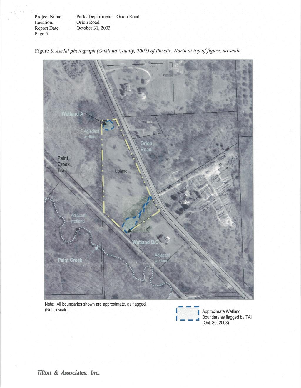
23 PARCEL NO PROJECT SITE (±2.97 ACRES) PARCEL NO (±2.72 ACRES) WETLAND PEA, Inc Rochester Ct., Ste. 100 Troy, MI t: f:

24 PEA, Inc Rochester Ct., Ste. 100 Troy, MI t: f:

25 PEA, Inc Rochester Ct., Ste. 100 Troy, MI t: f:
26 NOTE: PROJECT SITE IS OWNED BY CHARTER TOWNSHIP OF OAKLAND WITH THE EXCEPTION OF THE CONNECTION TO THE PAINT CREEK TRAIL, WHICH IS OWNED BY THE PAINT CREEK TRAIL 5.69 ACRES: TOTAL SITE AREA 2.97 ACRES: ON CHARTER TOWNSHIP OF OAKLAND PARCEL PARCEL NO (±2.97 ACRES) OVERALL SITE BOUNDARY 2.72 ACRES: ON CHARTER TOWNSHIP OF OAKLAND PARCEL PARCEL NO (±2.72 ACRES) AREA OF PROJECT ON PAINT CREEK TRAIL PROPERTY PEA, Inc Rochester Ct., Ste. 100 Troy, MI t: f:
27

28 PEA, Inc Rochester Ct., Ste. 100 Troy, MI t: f:

29 PEA, Inc Rochester Ct., Ste. 100 Troy, MI t: f:

30 PEA, Inc Rochester Ct., Ste. 100 Troy, MI t: f:

31 PEA, Inc Rochester Ct., Ste. 100 Troy, MI t: f:
32


33 PEA, Inc Rochester Ct., Ste. 100 Troy, MI t: f:
34
35


36 TF Iron Belle Paint Creek Trail Northern Trailhead Development Photos West Property Line: Large Oaks in Fence Row Large Bur Oak x Swamp White Oak


37 Prairie Groundcover: Native Pasture Rose Stiff Goldenrod and Mountain Mint Understory near Western Boundary Line


38 Walking from northwest corner of parcel south to Paint Creek Trail. Looking toward Orion Road in old Detroit Urban Railroad Right-of-Way showing lack of large trees.
39
40
41
42
43
44 TF Iron Belle - Paint Creek Trail Northern Trailhead Maintenance Plan (March 1, 2018) Proposed Trailhead Support Facilities and Natural Areas A gravel parking lot consisting of 30 spaces, two entry drives, plus 3 asphalt-paved ADA accessible parking spaces and pathway, and two horse trailer parking spaces. Expected life of gravel surface is 10 years. Expected life of asphalt surfacing is 25 years. ADA accessible 12 wide aggregate pathway approximately 400 linear feet long. A.5-acre bioswale and native prairie restoration area acres of natural areas (5.69 acre parcel minus 1.25 acres for development of facilities and minus.5 acre for bioswale/prairie planting). Mowed horse trail approximately 450 linear feet long. Double Restroom Cedar-sided Structure gallon Vault Toilets (approximately 15,000 uses per vault*). Life expectancy of vault toilet cedar-sided structure is 25 years and vault will be 35+ years. Hand pump well. Life expectancy of well pump is 10 years. *Gallagher Road to Clarkston Road Section of Paint Creek Trail Estimated 25,000 uses May Sept Current Maintenance Budget Oakland Township s Parks and Recreation Parks millage funds the improvements, operation and maintenance of the 5+ miles of the Paint Creek Trail that are located in Oakland Township. Oakland Township's 2017/2018 Parks and Recreation Millage budget for these services will total $38,200 plus $36,500 is also being reserved from this budget each year in preparation for the 2018/2019 resurfacing of the entire Paint Creek Trail. Annual Maintenance Schedule and Costs for Iron Belle - Paint Creek Trail Northern Trailhead TASK NAME FREQUENCY ESTIMATED CONTRACTOR COST ANNUAL STAFF TIME ($17/hr) Park Inspection Weekly 50 hours staff time 1 person Litter Control Weekly 40 hours staff time 1 person Mowing trail Biweekly $2500 and area surrounding parking lot and entrance drive EQUIPMENT/ MATERIALS COST $250 COMMENTS
45 TASK NAME FREQUENCY ESTIMATED CONTRACTOR COST ANNUAL STAFF TIME ($17/hr) EQUIPMENT/ MATERIALS COST COMMENTS Grading and Replenishment of Parking Lot and Trail Limestone Surface Parking Lot Snow Removal Spring and Fall As Needed 18 hours staff time 1 person 20 hours staff time 1 person $ for limestone delivered $300 Restroom Interior Cleaning and Paper Products Pumping of restroom vaults Weekly Yearly $ hours staff time 1 person $500 for cleaning/paper supplies Well Winterization/ Spring Opening Well Water testing Spring and Fall $300 in Spring 4 hours staff time 1 person in Fall Quarterly 8 hours staff time 1 person $30 for tests Contractor chlorinates in spring. Management of Bioswale and native plantings Invasive Plant Management Annual Annual 5 hours staff time 1 person 24 hours staff time 1 person $75 Spot treat invasives, overseeding $350 Spot treat invasives, overseeding TOTALS $3,300 $6,273 $1,755 GRAND TOTAL $11,328
46 Additional Maintenance Costs TASK NAME FREQUENCY ANNUAL STAFF TIME Replacement of aggregate lot & trail surface Replacement of Well Pump Prescribed burning of bioswale and native planting Staining of Restroom Siding TOTAL 25-Year COSTS CONTRACTORR, EQUIPMENT/MATERIALS COST TOTAL COST DURING 25 YEARS 10 year cycle $10,000 $20, year cycle $500 $1,000 3 Year Cycle Performed by contractor 5 year cycle 16 hours staff time, 1 person $1000 $8,000 $200 $2,360 $31,360 Total Life Cycle Cost Estimate TASK NAME FREQUENCY ANNUAL STAFF TIME CONTRACTOR, EQUIPMENT/MATERIALS COST TOTAL LIFE CYCLE COST DURING 25 YEARS Design/Construction Once $294,600 Annual Maintenance Annual $6,273 $5,055 $283,200 Additional Maintenance As Necessary $31,360 TOTAL 25-Year COST $609,160
OAKLAND TOWNSHIP PARKS AND RECREATION MILLAGE RENEWAL AUGUST 2, 2016 BALLOT PROPOSAL QUESTIONS & ANSWERS PULL-OUT SECTION (APRIL 21, 2016)
") OAKLAND TOWNSHIP PARKS AND RECREATION MILLAGE RENEWAL AUGUST 2, 2016 BALLOT PROPOSAL QUESTIONS & ANSWERS PULL-OUT SECTION (APRIL 21, 2016) 2007 2016 Millage Accomplishments Timeline in Pull-out The Mission
OAKLAND TOWNSHIP PARKS AND RECREATION MILLAGE RENEWAL AUGUST 2, 2016 BALLOT PROPOSAL QUESTIONS & ANSWERS PULL-OUT SECTION (APRIL 21, 2016) 2007 2016 Millage Accomplishments Timeline in Pull-out The Mission
2018 Paint Creek Trail News
 2018 Paint Creek Trail News Message from Trail Manager Kristen Myers. Welcome to our first Paint Creek Trail Newsletter! We have a lot going on this year, and we wanted to reach out to our Friends and
Conservation Area Management Statement
 Conservation Area Management Statement Miller Creek Wildlife Area Resolution #: Approval: Issue Date: Date of Last Revision: Table of Contents 1. Purpose....... 1 2. Property Description...... 1 2.1. Legal
National Recreation Trail Application for Designation
 National Recreation Trail Application for Designation Introduction Thank you for your interest in the National Recreation Trail (NRT) program. Completed NRT application packages must be submitted by December
Logo Department Name Agency Organization Organization Address Information 5700 North Sabino Canyon Road
 Logo Department Name Agency Organization Organization Address Information United States Forest Coronado National Forest 5700 North Sabino Canyon Road Department of Service Santa Catalina Ranger District
Appendix 3. Greenway Design Standards. The Whitemarsh Township Greenway Plan
 Appendix 3 Greenway Design Standards This chapter discusses two design standards for the greenway types discussed above. First, trail design standards are presented together with trailhead facilities and
National Recreation Trail Update Form
 National Recreation Trail Update Form Introduction Thank you for taking the time to complete this form. Your assistance will help ensure that the National Recreation Trail (NRT) database is complete and
2. Goals and Policies. The following are the adopted Parks and Trails Goals for Stillwater Township:
 D. PARKS AND TRAILS 1. Introduction Stillwater Township s population is relatively low, with most residents living on rural residences on large lots. The need for active park space has been minimal in
National Forests and Grasslands in Texas
 United States Department of Agriculture Forest Service National Forests and Grasslands in Texas Sam Houston NF 394 FM 1375 West New Waverly, Texas 77358 Phone 936-344-6205 Dear Friends, File Code: 1950
Acquisition in fee simple of approximately one-half acre of property on the shore of Spring Lake to expand the Lakeside Beach Park.
 Lakeside Beach TF00-136 $122,550.00 in fee simple of approximately one-half acre of property on the shore of Spring Lake to exp the Lakeside Beach. 2000 River Ravines TF00-150 $910,000.00 in fee simple
Rule Governing the Designation and Establishment of All-Terrain Vehicle Use Trails on State Land
 Rule Governing the Designation and Establishment of All-Terrain Vehicle Use Trails on State Land 1.0 Authority 1.1 This rule is promulgated pursuant to 23 V.S.A. 3506. Section 3506 (b)(4) states that an
Preferred Recreation Recommendations Stemilt-Squilchuck Recreation Plan March 2018
 Preferred Recreation Recommendations Stemilt-Squilchuck Recreation Plan March 2018 Below are the recommended recreation ideas and strategies that package together the various recreation concepts compiled
Chapter 6: POLICY AND PROCEDURE RECOMMENDATIONS
 Chapter 6 POLICY AND PROCEDURE RECOMMENDATIONS FOR SRRA Below are seven policy elements that should be considered for adoption by the Southwest Regional Recreation Authority of Virginia: 1. Develop strategies
Port Gamble Shoreline Area Conceptual Trail Proposal
 The North Kitsap Trails Association is pleased to be a partner to the Kitsap Forest and Bay Project and assist Kitsap County, Forterra, Olympic Property Group, Great Peninsula Conservancy and the Port
ETOBICOKE CREEK NORTH TRAIL PROJECT. May 18, 2017 at Michael Power High School 105 Eringate Drive, Etobicoke ON M9C 3Z7
 ETOBICOKE CREEK NORTH TRAIL PROJECT May 18, 2017 at Michael Power High School 105 Eringate Drive, Etobicoke ON M9C 3Z7 1 Purpose of Open House The purpose of today s open house is to present the design
City of Haslett. City of East Lansing. City of East Lansing
 Central Park North (Nancy L. Moore Park) Lake Park North Expansion White Park Expansion #2 White Park Expansion #1 County East East Haslett East East TF87-212 Acquisition $90,000.00 Park. TF08-138 Acquisition
City of Durango 5.8 FUNDING TRAILS DEVELOPMENT
 5.8 FUNDING TRAILS DEVELOPMENT The City has been successful in establishing dedicated local funding sources as well as applying for grants to develop the City s trail system, having received nearly $2.4
Lake Myra County Park. Wake County, North Carolina Community Forum #2 June 12, 2008
 Lake Myra County Park Wake County, North Carolina Community Forum #2 June 12, 2008 Welcome and Introduction Meeting Agenda Welcome Introductions of Project Team Master Plan Process Community Forum #1 Updates
FEASIBILITY CRITERIA
 This chapter describes the methodology and criteria used to evaluate the feasibility of developing trails throughout the study areas. Land availability, habitat sensitivity, roadway crossings and on-street
MORGAN CREEK GREENWAY Final Report APPENDICES
 APPENDICES MORGAN CREEK GREENWAY Appendix A Photos of Existing Conditions in Trail Corridor Photos of existing conditions Main trail corridor - February 2009 Photos of existing conditions south bank Morgan
METROPOLITAN COUNCIL 390 North Robert Street, St. Paul, MN Phone (651) TDD (651)
 TDD (651)") DATE: March 27, 2012 METROPOLITAN COUNCIL 390 North Robert Street, St. Paul, MN 55101 Phone (651) 602-1000 TDD (651) 291-0904 TO: Metropolitan Parks and Open Space Commission FROM: Arne Stefferud, Planning
DATE: March 27, 2012 METROPOLITAN COUNCIL 390 North Robert Street, St. Paul, MN 55101 Phone (651) 602-1000 TDD (651) 291-0904 TO: Metropolitan Parks and Open Space Commission FROM: Arne Stefferud, Planning
Understanding the caring capacity of the visitor experience Provide facilities to support a high level user experience Address visual quality through
 Understanding the caring capacity of the visitor experience Provide facilities to support a high level user experience Address visual quality through recreation ecological restoration opportunities Collaboration
Fossil Creek Wild & Scenic River Comprehensive River Management Plan Forest Service Proposed Action - details March 28, 2011
 Fossil Creek Wild & Scenic River Comprehensive River Management Plan Forest Service Proposed Action - details March 28, 2011 Primary Goals of the Proposed Action 1. Maintain or enhance ORVs primarily by
METROPOLITAN COUNCIL 390 North Robert Street, St. Paul, MN Phone (651) TDD (651)
 TDD (651)") METROPOLITAN COUNCIL 390 North Robert Street, St. Paul, MN 55101 Phone (651) 602 1000 TDD (651) 291 0904 DATE: June 19, 2007 TO: Metropolitan Parks and Open Space Commission FROM: Jan Youngquist, Senior
METROPOLITAN COUNCIL 390 North Robert Street, St. Paul, MN 55101 Phone (651) 602 1000 TDD (651) 291 0904 DATE: June 19, 2007 TO: Metropolitan Parks and Open Space Commission FROM: Jan Youngquist, Senior
COMMUNITY MEETING NOVEMBER 1, Wheaton Regional Park Pine Lake Trail
 COMMUNITY MEETING NOVEMBER 1, 2012 MEETING AGENDA I. Introduction of Project Team II. Trail Renovation Process III. Wheaton Regional Park IV. Pine Lake Trail Renovation Project V. Comments and Questions
RATTLESNAKE HILL PHILLIPS, HARRIS FARM, LIME KILN & QUARRY
 Town of, MA Trails Map 6a SPLIT ROCK PRIMARY SECONDARY PRIVATE PRIVATE PROPERY STAY ON HEAD FUTURE TO SKINNER (NOT MARKED) 0 miles 0.25 0.250 0.5 Mapbox, Data Odbl, OpenStreetMap contributors primary use
CHAPTER III: TRAIL DESIGN STANDARDS, SPECIFICATIONS & PERMITS
 CHAPTER III Trail Design Standards, Specifications & Permits This chapter discusses trail standards, preferred surface types for different activities, permits, and other requirements one must consider
Understanding user expectations And planning for long term sustainability 1
 Understanding user expectations And planning for long term sustainability 1 What is a natural surface trail? It can be as simple has a mineral soil, mulched or graveled pathway, or as developed as elevated
Rogue River Access and Management Plan Draft Alternatives
 Rogue River Access and Management Plan Draft Alternatives The Rogue River Access and Management Plan was initiated in December, 2011 and is being led by Jackson County Parks (JCP) and Oregon Department
TRAILS WHERE TO FIND TRAILS IN NOVA SCOTIA
 TRAILs SIGNAGE Know the Signs............................ 44 WHERE YOU CAN RIDE Roads and Highways........................ 46 Designated Trails........................... 47 Established Trails...........................
APPENDIX A: Survey Instruments
 Three different surveys were conducted during the research phase of the NCHA Trails Study. One questionnaire was designed for elected officials and user groups (general public). The other two questionnaires
Blue River Trail Master Plan JSA to Town Hall June 2004
 Blue River Trail Master Plan JSA to Town Hall June 2004 Prepared for: Silverthorne Town Council Silverthorne SPORT Committee Department of Recreation and Culture Silverthorne Public Works Silverthorne
Stony Creek Master Plan Public Meeting #2. May 21, 2016
 Stony Creek Master Plan Public Meeting #2 May 21, 2016 Today s Agenda 10:00 10:20 am Presentation 10:20 10:45 am Q & A 10:45 11:30 am Browse, discuss, and comment Metroparks Master Plan Process 4 months
Business Item No XXX. Proposed Action That the Metropolitan Council approve the Coon Creek Regional Trail Master Plan.
 Business Item No. 2015-XXX Metropolitan Parks and Open Space Commission Meeting date: July 7, 2015 For the Community Development Committee meeting of July 20, 2015 For the Metropolitan Council meeting
Sibley LUPA. Board Executive Committee Meeting December 7, 2017
 Sibley LUPA Board Executive Committee Meeting December 7, 2017 Project Location & Project Area 1,318-acre Robert Sibley Volcanic Regional Preserve Project Area Purpose Project Purpose & Goals Append the
MPRB: Southwest LRT Community Advisory Committee Issues and Outcomes by Location Current to: 12 November 2010
 MPRB: Southwest LRT Community Advisory Committee Issues and Outcomes by Location Current to: 12 November 2010 This is a compilation of issues and outcomes identified by the CAC. It is a work in progress,
Nov. 19 th Public Workshop Summary
 On November 19 th, more than 60 community members attended an Open Space Matters workshop at the Linen Building in downtown Boise for over two hours. Participants learned about reserves, discussed the
MASTER PLAN EXECUTIVE SUMMARY
 Biscuit Run State Park Scottsville Road (State Route 20) Charlottesville, VA 22902 Biscuit Run State Park MASTER PLAN EXECUTIVE SUMMARY Department of Conservation and Recreation Division of Planning and
DRAFT. Dorabelle Campground Rehabilitation
 DRAFT Dorabelle Campground Rehabilitation September 2012 1.1 REGIONAL SETTING AND PROJECT LOCATION The Dorabelle Campground is located on the western shore of Shaver Lake in Fresno County, California (Section
TRAIL DATABASE SCHEMA (8/26/2014)
") Trail Data Model for LINES Source Data Source Agency dataagency Agency or entity that created the dataset where the original line was sourced from. Source Date of Last Data Used to Update sourcedate Publication
Trail Data Model for LINES Source Data Source Agency dataagency Agency or entity that created the dataset where the original line was sourced from. Source Date of Last Data Used to Update sourcedate Publication
$866,000. $1,400,000 Health Benefits $13,156,000 TOTAL ANNUAL DIRECT BENEFITS. $10,890,000 Economic Benefits
 SINGING RIVER TRAIL Trails Create Value + Generate Economic Activity Trails generate economic returns through improved health, safety, and environmental conditions, raise property values, and attract visitors.
White Mountain National Forest Saco Ranger District
 United States Department of Agriculture Forest Service White Mountain National Forest Saco Ranger District 33 Kancamagus Highway Conway, NH 03818 Comm: (603) 447-5448 TTY: (603) 447-3121 File Code: 1950
Hudson Highlands Fjord Trail Draft Master Plan. April 29, 2015
 Hudson Highlands Fjord Trail Draft Master Plan April 29, 2015 Agenda Route Overview Proposed Segment Results of Community Survey on that Segment Next Steps Municipal Endorsement Environmental Review Implementation
Non-Motorized Transportation
 Non-Motorized Transportation Non-motorized facilities are important components to the transportation system. They provide an environmentally-friendly, low-cost mode of travel. Some of the facilities can
THAT the Board approve the final proposed concept plan for the Jericho Marginal Wharf site as shown in Figure C-4 of Appendix C.
 Date: January 17, 2012 TO: Board Members Vancouver Park Board FROM: General Manager Parks and Recreation SUBJECT: Jericho Marginal Wharf Phase 2 Concept Plan RECOMMENDATION THAT the Board approve the final
Yuba Creek Natural Area Acquisition. Acme Township. Acme Township. TF Acquisition $1,576, Grand Traverse
 Yuba Creek Natural Area TF00-162 $1,576,021.00 in fee simple of 403 acres of critical wetls upl habitat with over 5,000 feet of frontage on Yuba Creek, a tributary to the east arm of Bay. 2000 Petobago
Chapter 2: Summary of Existing Open Space System
 Chapter 2: Summary of Existing Open Space System In 1976, the Wake County Board of Commissioners established the Wake County Parks and Recreation Department in order to provide park facilities and programs
10/25/2013. What is the SCORP?! 2013 Local Government Survey 2013 Statewide Public Survey Advisory Group Priority Areas Your Suggestions!
 COLORADO OUTDOOR RECREATION TRENDS RESULTS FROM THE SCORP AND STATEWIDE Colorado Outdoor Recreation Resource Partnership September 2013 PRESENTATION What is the SCORP?! 2013 Local Government Survey 2013
Wilds. Headwaters. Lakes. Oxbows. Falls
 56 5 4 3 Wilds Headwaters Lakes Oxbows Falls 57 Zones It could be said the on-the-ground essence of this master plan appears within the next 6 pages of this report. As we learned in the preceding Cultural
U.S. Army Corps of Engineers Fiscal Year 2013 Handshake Program Application
 U.S. Army Corps of Engineers Fiscal Year 2013 Handshake Program Application Please review instructions before completing application! Corps Lake/Project Name:Rathbun Lake/ North Shore Trail Handshake Proposal
112th CONGRESS. 1st Session H. R. 113 IN THE HOUSE OF REPRESENTATIVES
 HR 113 IH 112th CONGRESS 1st Session H. R. 113 To provide for additions to the Cucamonga and Sheep Mountain Wilderness Areas in the Angeles and San Bernardino National Forests and the protection of existing
TRUCKEE TAHOE AIRPORT DISTRICT BOARD OF DIRECTOR STAFF REPORT
 AGENDA ITEM: 11 TRUCKEE TAHOE AIRPORT DISTRICT BOARD OF DIRECTOR STAFF REPORT AGENDA TITLE: MEETING DATE: January 24, 2018 PREPARED BY: NTPUD Agency Partnership Opportunity, Multi-Use Trailhead Access
FINAL TESTIMONY 1 COMMITTEE ON RESOURCES UNITED STATES HOUSE OF REPRESENTATIVES. July 13, 2005 CONCERNING. Motorized Recreational Use of Federal Lands
 FINAL TESTIMONY 1 STATEMENT OF DALE BOSWORTH CHIEF Of the FOREST SERVICE UNITED STATES DEPARTMENT OF AGRICULTURE Before the SUBCOMMITTEE ON FORESTS AND FOREST HEALTH And the SUBCOMMITTEE ON NATIONAL PARKS,
Emily to Blind Lake Trail PROPOSED TRAIL DEVELOPMENT APPLICATION SUMMARY
 Emily to Blind Lake Trail PROPOSED TRAIL DEVELOPMENT APPLICATION SUMMARY Township 137 Range 26 (Fairfield Township) sections 2 & 3 Township 138 Range 26 (City of Emily) sections 27, 34, 35, & 36 Township
Welcome to the future of Terwillegar Park a Unique Natural Park
 Welcome to the future of Terwillegar Park a Unique Natural Park 1 Introduction The Terwillegar Park Concept Plan study will develop an overall concept plan, management objectives and development guidelines
Committee Report. Community Development Committee For the Metropolitan Council meeting of August 12, Business Item No.
 Committee Report Business Item No. 2015-168 Community Development Committee For the Metropolitan Council meeting of August 12, 2015 Subject: Coon Creek Regional Trail Master Plan, Anoka County Proposed
Sawtooth National Forest Fairfield Ranger District
 United States Department of Agriculture Forest Service Sawtooth National Forest Fairfield Ranger District P.O. Box 189 Fairfield, ID. 83327 208-764-3202 Fax: 208-764-3211 File Code: 1950/7700 Date: December
Chapter 6. Trail Design. Trail Design
 Chapter 6 Trail Design Trail Design The trail winds through a region rich in scenic beauty, cultural, and natural history. Volunteer landscape architects working with the Core and Planning Teams, have
Wallace Falls State Park Classification and Management Planning Stage 3 Preliminary Recommendations July 18, 2018 Sultan City Hall
 Wallace Falls State Park Classification and Management Planning Stage 3 Preliminary Recommendations July 18, 2018 Sultan City Hall Thanks for coming! This document contains State Parks preliminary recommendations
APPENDIX F List of Commitments
 APPENDIX F List of Commitments s Table F.1 Standard Mitigation Measures Mitigation Measure MnDOT Specification Number Status Update Description Status Update Utilities Provide early notice to utility operators
Business Item No
 Metropolitan Parks and Open Space Commission Meeting date: February 6, 2018 For the Community Development Committee meeting of February 20, 2018 For the Metropolitan Council meeting of February 28, 2018
EXECUTIVE SUMMARY PROGRAM DEVELOPMENT REPORT PURPOSE EXISTING SETTING EXPANDING PARKLAND
 EXECUTIVE SUMMARY PROGRAM DEVELOPMENT REPORT PURPOSE As the culmination of the first phase of the master planning process, this Program Development Report creates the framework to develop the Calero County
B10. Agate Beach State Recreation Site
 B10. Agate Beach State Recreation Site Location Within the City of Newport, just south of the Yaquina Head Outstanding Natural Area. The park is located along the west side of Highway 101 at the mouth
O REGON TRAILS SUMMIT. Oregon Trails Summit. Rogue River National Forest
 O REGON TRAILS SUMMIT Oregon Trails Summit 2014 Rogue River National Forest OREGON TRAILS 2015: A VISION FOR THE FUTURE The 2015-2024 Oregon Statewide Trails Plan Why do a trails plan? 2005-2014 Oregon
NEW MEADOWS PARK PROPOSED MASTER PLAN
 NEW MEADOWS PARK PROPOSED MASTER PLAN A vision for your neighborhood park, the draft master plan is ready for your review. Tuesday September 12 th, 2017 5:30-7:00 PM Hellgate School District #4 middle
ROAD AND TRAIL PROJECT APPROVAL
 ROAD AND TRAIL PROJECT APPROVAL www.marincountyparks.org Marin County Parks, 3501 Civic Center Dr, Suite 260, San Rafael, CA 94903 DATE: July 12, 2017 PRESERVE: Gary Giacomini Open Space Preserve PROJECT:
Flow Stand Up Paddle Board Parkway Plan Analysis
 Regional Parks Department Jeffrey R. Leatherman, Director County of Sacramento Divisions Administration Golf Leisure Services Maintenance Rangers Therapeutic Recreation Services Flow Stand Up Paddle Board
Blueways: Rivers, lakes, or streams with public access for recreation that includes fishing, nature observation, and opportunities for boating.
 Parks, Open Space and Trails PRINCE WILLIAM COUNTY 2008 COMPREHENSIVE PLAN TRAILS PLAN CONTENTS The components of the trails plan are: Intent Definitions Goals, Policies, and Action Strategies Trails Map
Segment 2: La Crescent to Miller s Corner
 goal of the USFWS refuges is to conserve, protect and enhance fish, wildlife and plants and their habitats for the continuing benefit of the American people. Refuge lands are used largely for fishing,
MANAGEMENT DIRECTION STATEMENT June, 1999
 Thompson River District MANAGEMENT DIRECTION STATEMENT June, 1999 for Roche Lake Provincial Park Ministry of Environment Lands and Parks BC Parks Division Table of Contents I. Introduction A. Setting
RECREATION. Seven issues were identified that pertain to the effects of travel management on outdoor recreation within portions of the project area.
 RECREATION Seven issues were identified that pertain to the effects of travel management on outdoor recreation within portions of the project area. OPPORTUNITIES FOR SOLITUDE / QUIET TRAILS. One attraction
Greater Minnesota Regional Parks and Trails Commission Designation Application
 Greater Minnesota Regional Parks and Trails Commission Designation Application General Section Designation Application #: 15-059D Date Submitted: 06/16/2015 Park or Trail Name: Mesabi Trail District #:
Camping (Primitive) Camping (RV) Electrical Potable Water Grill Established Fire Pit Picnic Table
 Camping (RV) Electrical Potable Water Grill Established Fire Pit Picnic Table") Alden - 9th Road River Mile 777 Map: 38.20833, -98.32031 Managing Agency: Kansas Department of Wildlife, Parks & Tourism Nearest Community: Alden, Rice County Kansas Developed Amenities Provided Parking
Alden - 9th Road River Mile 777 Map: 38.20833, -98.32031 Managing Agency: Kansas Department of Wildlife, Parks & Tourism Nearest Community: Alden, Rice County Kansas Developed Amenities Provided Parking
MARBLE RIVER PROVINCIAL PARK
 MARBLE RIVER PROVINCIAL PARK PURPOSE STATEMENT AND ZONING PLAN March 2003 MARBLE RIVER PROVINCIAL PARK Purpose Statement and Zoning Plan Primary Role The primary role of Marble River Park is to protect
BACKCOUNTRY TRAIL FLOOD REHABILITATION PROGRAM
 BACKCOUNTRY TRAIL FLOOD REHABILITATION PROGRAM Backcountry Trail Flood Rehabilitation A June 2013 Flood Recovery Program Summary In June 2013, parts of Southern Alberta were devastated from significant
Environment and Natural Resources Trust Fund 2019 Request for Proposals (RFP)
") Environment and Natural Resources Trust Fund 2019 Request for Proposals (RFP) Project Title: Glacial Edge Trail and Downtown Pedestrian Bridge Category: G. Land Acquisition for Habitat and Recreation ENRTF
Environment and Natural Resources Trust Fund 2019 Request for Proposals (RFP) Project Title: Glacial Edge Trail and Downtown Pedestrian Bridge Category: G. Land Acquisition for Habitat and Recreation ENRTF
Gravel and Rock Extraction Highway Maintenance, Recapitalization and Twinning
 Gravel and Rock Extraction Highway Maintenance, Recapitalization and Twinning Backgrounder: Mountain National Parks A Need for Change Existing supplies of aggregate (sand and gravel) for highway maintenance,
Dungeness Recreation Area County Park Master Plan
 Dungeness Recreation Area County Park Public Outreach Meeting October 10, 2007 Project Overview USFWS Site Dungeness Recreation Area County Park Meeting Objectives: Re-Introduce project; provide status
Silver Lake Park An Environmental Jewel for the Citizens of Prince William County
 Silver Lake Park An Environmental Jewel for the Citizens of Prince William County The Prince William Park Authority Mission Statement states: The Prince William County Park Authority will create quality
Crystal Lake Area Trails
 Lake Area Trails Welcome to the Lake area of the Big Snowy Mountains! This island mountain range in central Montana features peaks reaching to 8,600 feet and long, high ridges from which vistas of the
2016 Regional Transportation Alternatives Program (TAP) Grant Application
 Grant Application") 2016 Regional Transportation Alternatives Program (TAP) Grant Application PROJECT TITLE: Yelm-Tenino Trail Extension Feasibility Study TRPC use only GENERAL PROJECT INFORMATION Agency or Organization City
2016 Regional Transportation Alternatives Program (TAP) Grant Application PROJECT TITLE: Yelm-Tenino Trail Extension Feasibility Study TRPC use only GENERAL PROJECT INFORMATION Agency or Organization City
NAVAJO COMMUNITY PLAN
 NAVAJO COMMUNITY PLAN Prepared by the NAVAJO COMMUNITY PLANNERS and THE CITY OF SAN DIEGO City of San Diego Planning Department 202 C Street, MS 4A San Diego, CA 92101 Printed on recycled paper. This information,
Northeast Quadrant Distinctive Features
 NORTHEAST QUADRANT Northeast Quadrant Distinctive Features LAND USE The Northeast Quadrant includes all the area within the planning area that is east of Interstate 5 and to the north of State Route 44.
Procedure for the Use of Power-Driven Mobility Devices on Mass Audubon Sanctuaries 1 September 17, 2012
 Procedure for the Use of Power-Driven Mobility Devices on Mass Audubon Sanctuaries 1 September 17, 2012 Background As part of Mass Audubon s mission to preserve the nature of Massachusetts for people and
Environment and Natural Resources Trust Fund (ENRTF) M.L ENRTF Work Plan (Main Document)
 M.L ENRTF Work Plan (Main Document)") Environment and Natural Resources Trust Fund (ENRTF) M.L. 2018 ENRTF Work Plan (Main Document) Today s Date: December 8, 2017 Date of Next Status Update Report: January 31, 2019 Date of Work Plan Approval:
Environment and Natural Resources Trust Fund (ENRTF) M.L. 2018 ENRTF Work Plan (Main Document) Today s Date: December 8, 2017 Date of Next Status Update Report: January 31, 2019 Date of Work Plan Approval:
Classifications, Inventory and Level of Service
 Classifications, Inventory and Level of Service Section 3 Kenmore Park, Recreation and Open Space Plan 1 P a g e Classifications and Inventory Park Classifications Kenmore classifies its parks based upon
Brinker Creek Ranch. Colorado - Routt County - Yampa
 Located at the base of the Flattops Range in the Steamboat/Vail corridor, Brinker Creek Ranch consists of 1,451 acres ideally suited for high country grazing and native grass hay production. Traditionally
INFORMATION NOTICE 15-2 Limited & Excluded Lands
 INFORMATION NOTICE 15-2 Limited & Excluded Lands Schedule 1 (Land Description) of onshore petroleum Agreements issued by the Department of Energy details the total hectares calculated. Total hectares are
F.O.K.O.S. Friends of Kingston Open Space A GUIDE TO KINGSTON OPEN SPACE
 F.O.K.O.S. Friends of Kingston Open Space A GUIDE TO KINGSTON OPEN SPACE Friends of Kingston Open Space (FOKOS) was formed when a handful of concerned citizens joined together to learn what could be done
Pinellas County Environmental Lands
 Pinellas County Environmental Lands In addition to traditional parks and recreation facilities, Pinellas County owns and manages a system of environmental lands that provides specialized resource-based
University Region Non-Motorized Plan 2015
 Non-Motorized Transportation Non-motorized facilities are important components to the transportation system. They provide an environmentally-friendly, low-cost mode of travel. Some of the facilities can
WASHTENAW COUNTY PARKS AND RECREATION COMMISSION
 WASHTENAW COUNTY PARKS AND RECREATION COMMISSION - BUDGET PROPOSED FISCAL YEARS JANUARY 1, DECEMBER 31, And PROJECTED FISCAL YEARS JANUARY 1, DECEMBER 31, Robert L. Tetens, Director TABLE OF CONTENTS Millage
Attendance Presentation
 TO The Community of Saanich FROM District of Saanich DATE January 30, 2017 RE Meeting Notes Haro Woods Jan 28th Community Engagement Goward House, 2495 Arbutus Road, Victoria BC Attendance In total, 18
COASTAL CONSERVANCY. Staff Recommendation December 2, 2004 COYOTE HELLYER COUNTY PARK BAY AREA RIDGE TRAIL
 COASTAL CONSERVANCY Staff Recommendation December 2, 2004 COYOTE HELLYER COUNTY PARK BAY AREA RIDGE TRAIL File No. 04-057 Project Manager: Amy Hutzel RECOMMENDED ACTION: Authorization to disburse up to
Proposed Scotchman Peaks Wilderness Act 2016 (S.3531)
") 1 Proposed Scotchman Peaks Wilderness Act 2016 (S.3531) Frequently Asked Questions PLACE Where is the area that would be designated as Wilderness? The lands outlined in S.3531 lie within Idaho along its
1 Proposed Scotchman Peaks Wilderness Act 2016 (S.3531) Frequently Asked Questions PLACE Where is the area that would be designated as Wilderness? The lands outlined in S.3531 lie within Idaho along its
Rating: 5.0 (scale of 1-10)
") 95 Community Trail System Groundcover: 2-metre paved path, 1- metre grass buffer on either side. Location: Fort St. John Ownership: City of Fort St. John Rating: 5.0 (scale of 1-10) Strategic value: Linear
95 Community Trail System Groundcover: 2-metre paved path, 1- metre grass buffer on either side. Location: Fort St. John Ownership: City of Fort St. John Rating: 5.0 (scale of 1-10) Strategic value: Linear
Hiawatha National Forest St. Ignace Ranger District. File Code: 1950 Date: August 5, 2011
 United States Department of Agriculture Forest Service Hiawatha National Forest St. Ignace Ranger District W1900 West US-2 St. Ignace, MI 49781 906-643-7900 File Code: 1950 Date: August 5, 2011 Dear National
Bear Creek Habitat Improvement Project
 06/10/10 Bear Creek Habitat Improvement Project El Paso County, Colorado Pike National Forest and Colorado Springs Utilities Owned Land Report prepared by: Eric Billmeyer Executive Director Rocky Mountain
Triangle Land Conservancy Conservation Area Monitoring Report Carolina North
 Triangle Land Conservancy Conservation Area Monitoring Report Carolina North Property Name: Bolin Creek West Conservation Area Date of visit: March 16, 2017 County: Orange Property Type: Restrictive Covenants
Triangle Land Conservancy Conservation Area Monitoring Report Carolina North
 Triangle Land Conservancy Conservation Area Monitoring Report Carolina North Property Name: Bolin Creek East Conservation Area Date of visit: 4/8/2015 County: Orange Property Type: Restrictive Covenants