[This page has been intentionally left blank]
|
|
|
- Lionel Floyd
- 6 years ago
- Views:
Transcription
1

2 [This page has been intentionally left blank]
3 Table of Contents Section Page Executive Summary... iii 1.0 Introduction Purpose Process Report Organization Existing Context Demographic Profile Trails Inventory Opportunities & Constraints Trail Planning and Development Policy Trends in the Trail System What the Public Told Us Public Input Sessions Key Informant Interviews Community Services Master Plan Input Public Meeting Trail Network Development Guiding Principles Trail Classification Hierarchy Recommended Trail Network Plan Trail Development Toolkit Design Standards & Guidelines Trails Sidewalks Cycle Lanes Policy Development Trail Management & Maintenance Risk Management and Liability Education & Promotion monteith brown planning consultants i
4 6.0 Implementation Strategy Trail Phasing Trail Acquisition Strategies Partnerships Capital Cost Estimates Operating Cost Estimates Potential Funding Sources Monitoring & Updating Appendix A Background Document Review Appendix B Summary of Public Input Session Appendix C Summary of Public Open House Comments monteith brown planning consultants ii
5 Executive Summary Executive Summary Driven by the increasing importance of active transportation choices and the pursuit of healthy lifestyles, trails and pathways are often identified as one of the most desired facility types, providing immeasurable community benefits to residents and visitors alike. Trails provide utilitarian and recreational linkages between destinations and are regarded as a quality of life indicator as they foster social connections and contribute to complete communities. The protection and enhancement of trail opportunities within the Municipality of Middlesex Centre was the impetus for preparing this Trails Master Plan, which has four main objectives: Identify a long-term trail development strategy for municipal trails, with a focus on non-motorized active transportation (e.g., walking and cycling) within developing communities; Identify where trails should be located and the types of amenities they require; Establish design guidelines and policy considerations to assist with plan implementation; and Engage the community and key informants in order to encourage a community-responsive plan. Several inputs were critical to the development of this Master Plan, including an analysis of demographic data and forecasts, trends in trail development and active transportation, assessment of opportunities and constraints, and consultation with the public and key stakeholders. Combining these inputs with key guiding documents including the Planning Act and Official Plans assisted with informing a trail development strategy that responds to community needs. The development strategy consists of a set of guiding principles that can be considered in identifying new trail opportunities and the review of development applications, supplemented by a trail classification system that identifies the desired use, function, and location of each trail type. Building upon these, a recommended trail network was developed, which includes over 64 kilometres of new trail and sidewalks in Middlesex Centre. To support the advancement of the Municipal trail network, a Trail Development Toolkit was developed, which includes design standards and guidelines, policy development tools, trail and risk management strategies, and opportunities for trail education and promotion. The recommended trail network is conceptual in nature and can be revised to respond to terrain characteristics or as new opportunities and linkages emerge during the life of this Master Plan. The recommended network gives high-level consideration to trails and sidewalks within undeveloped portions of settlement areas and should be regarded as a starting point for developers to incorporate a connected trail network within their planning applications. Through the land development process, it is anticipated that the trail network will expand beyond what is recommended in this Master Plan. It is estimated that the implementation of the Municipal portion of the proposed trail network is approximately $5 million over a 15 year period and beyond. Short term costs ( ) are estimated at nearly $0.8 million, medium term costs ( ) at $1.7 million, and long term costs (2030+) at $2.5 million. These estimates exclude land acquisition, inflation, trail amenities, and routes to be led by other partners, such as sidewalks and local pathways to be installed by the development community. A summary of capital cost estimates are contained in the following table. monteith brown planning consultants iii
6 Executive Summary Summary of Capital Cost Estimates for Implementing the Municipal Portion of Proposed Trail Network Cost $/m Short Term ( ) Medium Term ( ) Long Term (2030+) Distance (m) Sub-Total Distance (m) Sub-Total Distance (m) Sub-Total Primary Trail $ $36,320 0 $0 9,199 $1,471,840 Secondary Trail $75 1,835 $137,625 5,007 $375,525 9,152 $686,400 Sidewalk $150 2,036 $305,400 7,938 $1,190,700 2,124 $318,600 Tertiary Trail $75 4,107 $308,025 2,024 $151, $22,950 Total 8,205 $787,370 14,969 $1,718,025 20,781 $2,499,790 Exclusions: 18,514m of secondary trail and sidewalks proposed to be completed by developers in undeveloped settlement area lands. 1,496m of tertiary trail proposed within the Coldstream Conservation Area. Land acquisition and inflation. Summary of Recommendations Guiding Principles 1. Consider the guiding principles contained within this Master Plan in the review of new trail development opportunities or modifications to the recommended trail network. Trail Classification Hierarchy 2. Adopt the recommended trail hierarchy and incorporate the classification system in the Municipality s Official Plan during the next Five Year Review. 3. Encourage the County and adjacent municipalities to develop a County-wide cycling strategy focused on the establishment of cycling infrastructure. Recommended Trail Network 4. In order to enhance and expand the existing trail network in Middlesex Centre, the Municipality shall have regard to the trail routes recommended in this Master Plan. 5. Modifications to the recommended trail network shall be permitted to recognize unique terrain and other land features, at the Municipality s discretion, provided that the guiding principles and general intent are maintained. 6. Undertake revisions to the recommended trail network, as necessary, to recognize missing trail linkages and new trail opportunities during the life of the Master Plan. Policy Development 7. Amend the Official Plan to integrate land dedication policies for pedestrian and bicycle pathways as a condition of draft plan of subdivision approval, with consideration given to the recommended trail network contained in this Master Plan. 8. Create policies requiring developers to fund and construct off-road trails and pathways that primarily serve the local development, including connections to Municipal-wide and/or settlement area-wide trail networks. 9. To serve as an awareness tool and framework for trail development, include the recommended trail network as a Schedule in the Official Plan. The Official Plan should also make reference to the guiding principles and Trail Development Toolkit. 10. Establish Official Plan policies that strengthen support for active transportation, trail development, and pedestrian and bicycle infrastructure. 11. Encourage developers to communicate information to potential homebuyers about future trail development within and adjacent to new residential development through means including brochures, information packages, subdivision renderings, and Purchase Agreements. monteith brown planning consultants iv
7 Executive Summary Policy Development (continued) 12. Inform the public of trail development in advance of construction to engage the public and provide opportunities for public input during the design process and to promote the social and environmental benefits of trails. Trail Management & Maintenance 13. Integrate grass-cutting and vegetation management measures along trails into the Municipality s existing grass maintenance program. 14. Conduct an annual inspection of Municipal trails and sidewalks, preferably after spring thaw to provide optimal opportunity to identify damages or deficiencies and undertake repairs. 15. Monitor the quality and condition of existing trails and identify improvements, as necessary, with regard for the design guidelines contained in this Master Plan. Risk Management & Liability 16. Ensure that Municipal trails are appropriately managed in accordance with the recommended maintenance strategies contained in this Master Plan, together with relevant Municipal maintenance policies. Education & Promotion 17. Explore opportunities to promote trails in Middlesex Centre to raise awareness about the Municipal trail network, together with encouraging outdoor physical activity and educating the public on safe trail etiquette. Promotion or education strategies may be undertaken together with a community organization to leverage resources. Trail Phasing 18. Implement the recommended trail network as opportunities allow, with reference to the proposed phasing. Modifications to trail phasing may be required to recognize budget pressures, timing of residential development, coordination with public works or roadway projects, availability of volunteers or resources, and other key factors. Trail Acquisition Strategies 19. Utilize a range of acquisition strategies to secure non-municipal lands for trail development. Partnerships 20. Continue to build upon existing relationships and form new ones with local organizations, agencies, and service clubs who have an interest in trails, active transportation, and the betterment of Middlesex Centre. 21. When forming partnerships, enter into formal agreements to identify roles and responsibilities based on the abilities and resources of groups involved. Capital Cost Estimates 22. Establish an annual capital allocation within the Municipal budget for the construction of trail infrastructure. Operating Cost Estimates 23. Monitor the annual operational costs to establish an annual maintenance budget and adjust the budget in proportion to the trail network s growth. monteith brown planning consultants v

8 Executive Summary Potential Funding Sources 24. Pursue outside funding sources in addition to local level opportunities for the development and maintenance of trails. Monitoring & Updating 25. Prepare an annual staff report to Council on the status of the implementation strategy, including completed trail projects, partnerships, newly acquired lands, funding, and planning trail development goals to be accomplished in the coming year. 26. Undertake a full update to the Master Plan in five to ten years. This update should include a consultation process to solicit public and stakeholder input. monteith brown planning consultants vi


9 1.0 Introduction 1.0 Introduction 1.1 Purpose As established in the Municipality s Community Services Master Plan, trails are a highly valued contributor to the local quality of life in Middlesex Centre. An interconnected trails system is an important element of a broader active transportation system, which provides opportunities for physical activity for both recreation and utilitarian purposes and is an integral part of a healthy and complete community. This Trails Master Plan will guide the development of future trails and supporting amenities in Middlesex Centre. To achieve this, the Master Plan provides a framework for future trails design, construction, maintenance, and promoting the trail network, ultimately providing a toolkit that will guide the work of both the Municipality and the development community. The scope of this Master Plan focuses on pedestrian pathways within municipal parks and settlement areas, sidewalks in new and existing developments, and trail connections. Trails for motorized recreational vehicles and horseback riding are beyond the scope of this Master Plan. The Master Plan also provides high level, preliminary direction on potential cycling routes. The four main objectives of this Master Plan are to: Identify a long-term trail development strategy for the municipal trails, with a focus on nonmotorized active transportation (e.g., walking and cycling) within developing communities; Identify where trails should be located and the types of amenities they require; Establish design guidelines and policy considerations to assist with plan implementation; and Engage the community and key informants in order to encourage a community-responsive plan. 1.2 Process The preparation of the Middlesex Centre Trails Master Plan flows through three distinct phases as illustrated in the graphic to the right. The first phase formed the foundational component of the plan, which encapsulates key building blocks, including raising project awareness within the community, a review of key reports, policies, and standards, an assessment of existing trails, establishing guiding principles and route selection criteria, trail classification hierarchy, and public and stakeholder engagement. Research & Consultation Analysis & Development Formalize Master Plan Project Awareness Background Document Review Trails Inventory Guiding Principles & Route Selection Criteria Trail Hierarchy Development Public Engagement Identify Preferred Corridors, Linkages, and Trails Confirm Candidate Routes Policy Considerations Design Standards & Guidelines Wayfinding, Management, Education, and Promotion Draft Master Plan Implementation Strategy Public & Council Input Finalize Master Plan monteith brown planning consultants 1
10 1.0 Introduction The second phase of the analysis identified preferred trail routes based on the inputs from the initial phase and the Community Services Advisory Committee. A trail development toolkit was prepared, which identified considerations for the Official Plan and other strategic documents. Design standards, guidelines and elements such as wayfinding, trail management, education and promotion were also considered. Finally, the third phase consisted of the development of the draft Master Plan, which built upon previous phases and included an implementation strategy that established priorities, timing, and high level costing. 1.3 Report Organization The Trails Master Plan is organized as follows: Section 1: Section 2: Section 3: Section 4: Section 5: Section 6: Introduction Describes the Master Plan s purpose, process, and organization. Existing Context Contains a brief socio-demographic summary of Middlesex Centre, an inventory of existing trails in the Municipality, policies and initiatives that promote and encourage the provision of trails, and a cursory review of trends and benefits of trails through secondary research methods. What the Public Told Us Outlines the public s perceptions regarding municipal trails identified through the public information sessions and key informant interviews, as well as public comments collected from the Municipality s Community Services Master Plan. Trail Network Development Establishes the guiding principles for trail development and a trail hierarchy, in addition to identifying opportunities and constraints and the recommended trail network. Trail Development Toolkit Contains the technical building blocks for locating, designing, and constructing trails including design standards and guidelines, wayfinding and signage, trail management and maintenance practices, and education and promotion of municipal trails. Implementation Strategy Contains a summary of all recommendations contained in this Master Plan, along with suggested priorities and phasing for implementation. Capital costs have been explored in addition to potential funding sources and partnership considerations. monteith brown planning consultants 2
11 2.0 Existing Context 2.0 Existing Context Understanding the existing conditions in Middlesex Centre is important to evaluating local trail needs. This Section provides a brief overview of the Municipality s demographic profile to identify who lives here and how Middlesex Centre will grow throughout the life of this Master Plan. The current inventory of municipal trails is explored, which forms the foundation for the development of Middlesex Centre s recommended trail network. A summary of existing planning policy and emerging trends in the trail system has also been undertaken. 2.1 Demographic Profile In the 2011 short-form Census, Statistics Canada reported a population of 16,487 residents for the Municipality, representing an increase of nearly 6% recorded in the 2006 Census (15,589 residents). This growth in population is generally on par with the projected population contained in OPA No. 28 (16,917 residents). Based on the population forecast contained in OPA No. 28, it is anticipated that Middlesex Centre will continue to observe strong, stable growth towards 2031 as the population reaches 23,607 residents. Forecasted Population Growth of Middlesex Centre ( ) 26,000 24,000 22,000 20,000 18,000 16,000 14,000 14,242 15,589 16,487 18,397 20,130 21, ,607 Source: Statistics Canada, 2011; Official Plan Amendment No 28 (2011) According to the Municipality s Comprehensive Review (2010), much of this growth is anticipated to be accommodated in the Komoka-Kilworth and Ilderton settlement areas, and to a lesser degree in the communities of Arva and Delaware, given that these areas have full or partial municipal services. Over the next 20 years, it is estimated that the Middlesex Centre will add 2,485 new residential units. 1 At the time of developing this Master Plan, it is understood that there are several active plans of subdivisions in Coldstream, Delaware, Denfield, Ilderton, and Komoka-Kilworth. The 2011 National Household Survey 2 reported that Middlesex Centre s median income for individuals was $38,850, 31% higher than County and 28% higher than the Province. A similar trend is found when analyzing median household income in Middlesex Centre. Statistics Canada reported that the median household income for 2011 was $91,701, 58% higher than the County and 38% higher than the Province. 1 Municipality of Middlesex Centre. Comprehensive Review The National Household Survey was a voluntary, self-administered survey conducted for the first time in 2011 as a replacement for the long census questionnaire. Due to the survey methodology, the Municipality of Middlesex Centre has a non-response rate of 22.2%, which may affect data quality. monteith brown planning consultants 3
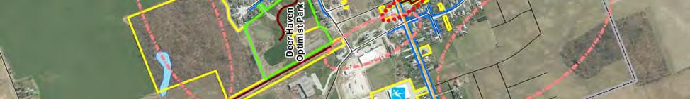
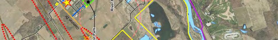
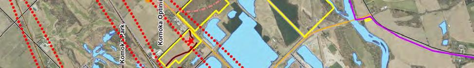
12 2.0 Existing Context The 2011 National Household Survey did not evaluate residents participation in walking or cycling for leisure; however, the Survey did assess residents mode of transportation to place of work. Less than 3% of the Municipality s employed labour force utilizes non-motorized methods of transportation such as walking and cycling, considerably less compared to the County (7%) and the Province (6%). The most common method of transportation in the Municipality is by private vehicle (as a driver or passenger 96%). This may be a result of several factors, including (but not limited to) the spatial distribution of the Municipality s communities, limited walking and cycling infrastructure, and the absence of connectivity to destinations. 2.2 Trails Inventory Residents have access to approximately 6.0 kilometres of municipal trails located throughout Middlesex Centre. The Rail Trail, the longest Municipally-maintained trail, spans approximately 3.1 kilometres in length and runs along a decommissioned rail link from Ten to Twelve Mile Road in Ilderton. This trail boasts a natural walking surface with connections to Junction and Deer Haven Optimist Park. The remaining 2.9 kilometres of trail are represented by walking paths dispersed throughout parks within the Municipality. Over 34 kilometres of recognized non-municipal trails are also available to residents. The Thames Valley Trail boasts nearly 16 kilometres of walking trail with a mix of walking surfaces and scenic environments. It should be noted, however, that the Thames Valley Trail is open members of the Thames Valley Trail Association only as the Association has agreements with private landowners to access their lands. Approximately 11 kilometres of trail is located in Komoka Provincial Park. 3.9 kilometres of trail are also located in the Coldstream Conservation Area. Many other informal trail routes may also exist on public and private lands. Given that this Master Plan primarily focuses on municipal trails, recommendations pertaining to non-municipal trails will not be explored. A more detailed description of the Municipality s most used trails can be found on the following pages and mapping is contained in Section 2.3. Community Trail / Park Name Length (m) Municipal Trails Arva Weldon Park Trail 1,778 Ilderton Ilderton Rail Trail 3,104 Deer Haven Optimist Trail 233 Poplar Hill Poplar Hill Park 66 Kilworth Westbrook Park 112 Komoka Komoka Park 119 Komoka Wellness Centre 563 Sub-Total 5,975 Non-Municipal Trails Komoka- Kilworth Poplar Hill / Coldstream Rural Komoka Provincial Park Trail Coldstream Conservation Area Cedar Walk Trail Sharon Creek Conservation Area Thames Valley Trail 11,400 3,914 2,703 15,949 Sub-Total 33,966 Total 39,941 Source: Municipality of Middlesex Centre, 2013 Note: Inventory does not include informal trails or trails proposed in OPA No 28 (2011) and CSMP (2012) monteith brown planning consultants 4


13 2.0 Existing Context Community Sidewalk Length (m) Arva 2,240 Birr 594 Bryanston 476 Delaware 3,830 Denfield 1,134 Ilderton 8,672 Kilworth 6,322 Komoka 3,508 Melrose 205 Poplar Hill 489 Total 27,470 Source: Municipality of Middlesex Centre, 2013 In addition to Middlesex Centre s off-road trail network, the Municipality provides over 27 kilometres of concrete and asphalt sidewalks in a number of settlement areas. The most extensive sidewalk networks are in Komoka-Kilworth and Ilderton, with 9.8 and 8.7 kilometres of sidewalk, respectively. Ilderton Rail Trail The Ilderton Rail Trail is one of the most popular trails in the Municipality. What once was an active rail line that ran from London to Goderich, the rail line was decommissioned, leaving an abandoned rail corridor for use by local residents and visitors. During the 1980s, sections of the former rail line were removed from the trail network and sold to limit concerns of liability. Stretching over 3.1 kilometres, the trail begins at Twelve Mile road to the north and extends to Deer Haven Optimist Park. A partition exists between the northern and southern portion; however, the trail resumes at Ilderton s main street and commercial hub, through Junction Park and towards Ten Mile Road to the south. Most recently the Municipality completed a new section of trail located south of the residences along Heritage Place and west of the Ilderton Fire Hall. This new section links Hyde Park Road with the southern portion of the Rail Trail, which has been described as the more developed portion of the trail. Through a qualitative assessment, the southern portion of the trail appears to be maintained well, featuring a wide and level walking surface with varying surface types, including granular and natural dirt. By contrast, the northern portion of the trail is generally more naturalized with a natural walking surface. Through partnership with the Ilderton Lions Club, two benches were also recently installed at key points along the southern trail. Other partners responsible for the Ilderton Rail Trail include the Upper Thames River Conservation Authority, Friends of Oxbow, Try Recycling Inc., and Environment Canada. monteith brown planning consultants 5
.")

14 2.0 Existing Context Komoka Provincial Park Although the Municipality does not maintain Komoka Provincial Park, the park is often boasted as having the most used and valued trail system in Middlesex Centre. Owned by Ontario Parks, the park is used frequently by residents across the Municipality and residents in adjacent communities (a portion of the park resides in the City of London). There are approximately 11.4 kilometres of trail that support a range of active opportunities. 4.4 kilometres of trail are designated walking and hiking routes, while the remaining 7 kilometres are designated mountain biking and equestrian trails. Motorized all-terrain vehicles and equestrian riders are prohibited from the walking and hiking trails. As previously identified, the main spine of the walking trail (known as the white trail ) forms part of the Thames Valley Trail and is maintained by the Thames Valley Trails Association. Currently, two trailheads to the Park exist, each providing parking and prominent signage and a map of the trail system. Signage also exists to remind dog owners that a leash must be used at all times. According to the Park Management Plan (2010), the Provincial Park has two Access Zones that provide designated recreation areas, relieving pressures in other areas that may contain more sensitive natural heritage features. The first access zone functions as a new access point south of the Thames River. The second access zone is located at the existing access point along Komoka Road, north of the Thames River, which functions as an informal access point. Once these access zones become more developed, it is understood that the two existing access points along Oxford Street and Gideon Drive will be closed given that they are located within proximity to the park s significant natural heritage features, including a number of species at risk. With respect to trail development in Komoka Provincial Park, Ontario Parks have been undertaking a trail system review to: determine which authorized trails should be closed and which should be relocated south of the Thames River in order to better protect natural and cultural heritage values, improve circulation, reduce duplication and allow for more efficient maintenance; confirm the continuing role of the trails system in providing a Thames Valley Trail link through the park; design an appropriate system of authorized trails north of the Thames; determine how unauthorized trails can be most effectively closed and rehabilitated; and specify appropriate trail development standards. 3 Weldon Park Trail Weldon Park is located in Arva, abutting Medway High School and minutes from the City of London. A popular trail loop measuring approximately 1.4 kilometres is located in this park and is punctuated by a range of active and passive outdoor recreation facilities including ball diamonds, tennis courts, playground equipment, open space, picnic area, and a pavilion. Portions of the trail serve a multi-purpose function, including motorized vehicles, and feature a dirt surface. Remaining portions of the trail are pedestrianoriented trails with walking surfaces including naturalized, 3 Ontario Parks. Komoka Park Management Plan monteith brown planning consultants 6

15 2.0 Existing Context woodchips, dirt, and granular. This site has been a popular location for local school cross-country meets in the past. Coldstream Conservation Area Similar to Komoka Provincial Park, the Municipality does not maintain the trails within the Coldstream Conservation Area; however, these trails are highly valued and used often by local residents. The Conservation Area is owned by the St. Clair Region Conservation Authority, which leases the land to the Municipality. The Municipality maintains portions of the Conservation Area with the assistance of the Coldstream Enviro-Friends. Two trails exist in the Conservation Area. The Cedar Walk Trail is approximately 1.7 kilometres of looped trail that features both dirt and woodchip walking surfaces, in addition to a popular boardwalk that is currently in the early stages of being repaired by the Conservation Authority in partnership with the Coldstream Enviro-Friends. Other ongoing projects include the removal of hazardous trees. The Quarry Trail is the second trail located in the Conservation Area on the east side of Coldstream Road. The looped trail is approximately 2.2 kilometres in length. A number of concerns were raised through the public consultation program, including encroachment, prohibited and illicit activities, users going off-trail, as well as safety concerns given that the trail is located in a forested area and trails created by users have made it easier to become disoriented. 2.3 Opportunities & Constraints Through an analysis of site investigations and public input (found in Section 3.0 of the Master Plan), a number of opportunities and constraints were identified in connection with the development of the Municipality s trail network. The following table presents the opportunities and constraints in no particular order. Key Opportunities Building upon Middlesex Centre s existing active transportation infrastructure and recognizing informal trail routes to ensure that they are safe and appropriately maintained. Connecting communities within Middlesex Centre as well as to key destination points throughout the Municipality. Linking the northern and southern portions of the Ilderton Rail Trail, within the Ilderton Core. Connecting Middlesex Centre with adjacent communities (e.g., London) offering active transportation choices. Enhancing open spaces within parks with designated trail loops to control and direct walking routes. Engaging the Municipality s active group of community partners and various agencies in the delivery, development and maintenance of the Trails Master Plan. The dedication of pedestrian and cycling pathways through new subdivision development. monteith brown planning consultants 7
16 2.0 Existing Context Key Constraints Lack of trail amenities such as signage, seating, washrooms and waste receptacles at the appropriate locations may discourage potential users, particularly young families and older adults. Lack of knowledge of trails within the Municipality can often deter potential users from local leisure activities or active transportation choices. Trail access through private lands (non-municipal ownership). Informal trail routes, often through privately-owned lands not controlled by the Municipality, may create hazardous and unsafe conditions in addition to potential issues with landowners. Given that the Municipality is largely rural, settlement communities are spread out over large distances, creating difficulties in developing an active transportation network. Crossing uncontrolled county roads such as Ilderton Road, Hyde Park Road, Komoka Road, and Glendon Drive. Highway traffic along major cycling routes. The following pages contain mapping of the Municipality s trails together with the opportunities and constraints for enhancing the existing trail network. monteith brown planning consultants 8
17 2.0 Existing Context Existing Trails Municipal-Wide monteith brown planning consultants 9


18 2.0 Existing Context Existing Trails Arva monteith brown planning consultants 10


19 2.0 Existing Context Existing Trails Delaware monteith brown planning consultants 11


20 2.0 Existing Context Existing Trails Denfield monteith brown planning consultants 12


21 2.0 Existing Context Existing Trails Ilderton monteith brown planning consultants 13


22 2.0 Existing Context Existing Trails Komoka-Kilworth monteith brown planning consultants 14


23 2.0 Existing Context Existing Trails Poplar Hill / Coldstream monteith brown planning consultants 15
24 2.0 Existing Context 2.4 Trail Planning and Development Policy This section explores some of the policies and planning documents that inform the development of the Master Plan. A more detailed listing of key documents can be found in Appendix A. The Ontario Planning Act A number of policy tools are currently in place to promote and encourage the provision of trails in Middlesex Centre. For example, the Ontario Planning Act, as well as the Middlesex Centre Official Plan, allows for the dedication of land for pedestrian and bicycle pathways, in addition to public transit right-ofways, as a condition of subdivision approval. Accessibility for Ontarians with Disabilities Act The Accessibility for Ontarians with Disabilities Act (AODA) was enacted in 2005 to remove barriers to accessibility in public and private areas. The AODA establishes accessibility standards for five key areas including customer service, employment, information and communications, transportation, and the design of public spaces (Note: regulations pertaining to each of these areas are being rolled out over time). In compliance with the AODA, Middlesex Centre has prepared an accessibility policy to express their commitment to providing services to persons with disabilities. An Accessibility Advisory Committee and Accessibility Plan have also been jointly developed with Middlesex County to identify strategies to prevent and remove barriers to meet the requirements of this legislation. By 2016, Middlesex Centre is required to meet the requirements of the design of public spaces standards, which identify standards for new and redeveloping recreational trails. The AODA describes these trails as public trails intended for recreational and leisure purposes, but does not include trails solely intended for cross-country skiing, mountain biking, motorized activity vehicles, wilderness and backcountry trails, and portage routes. Through the design and development of recreational trails in Middlesex Centre, the AODA requires that the appropriate groups be consulted (e.g., advisory committee and persons with disabilities) regarding a range of key considerations including, but not limited to, slope, ramps, and the design of resting areas, passing areas, viewing areas, amenities, and other pertinent features. Section 80.9(1) of the AODA outlines the minimum technical requirements for trail construction that Middlesex Centre shall meet for constructing new or redeveloping trails. Some of the key technical requirements are identified below. These requirements were taken into consideration through the development of this Master Plan s Trail Development Toolkit. A recreational trail must have a minimum clear width of 1,000mm A recreational trail must have a clear height that provides a minimum head room clearance of 2,100mm above the trail The surface of a recreational trail must be firm and stable The entrance to a recreational trail must provide a clear opening of between 850mm and 1,000mm, whether the entrance includes a gate, bollard or other entrance design A recreational trail must have at each trailhead signage that provides the following information: o The length of trail o The type of surface of which the trail is constructed o The average and minimum trail width o The average and maximum running slope and cross slope o The location of amenities, where provided monteith brown planning consultants 16
25 2.0 Existing Context Provincial Policy Statement The Provincial Policy Statement (PPS) provides support for the provision of recreational and trail opportunities. Maintaining that healthy, active communities should be promoted by providing for a full range and equitable distribution of publicly-accessible built and natural settings for recreation, including facilities, parklands, open space areas, trails and, where practical, water-based resources. The PPS is currently undergoing the five-year review in accordance with the Planning Act. A number of draft policies have been identified, which build upon the existing policy framework and strengthens the goals identified in the PPS. New draft policies, as they relate to trails, include strengthening support for active transportation modes and connectivity, as well as recognizing the importance of parks and recreation, green spaces, trails and trail linkages. County of Middlesex Official Plan The County of Middlesex is currently undertaking the Five Year Review of its Official Plan, which will involve a review of a number of areas impacting the provision and development of trails, including policies regarding transportation, intensification and redevelopment, natural heritage, and healthy and sustainable communities. The existing County Official Plan contains policies that encourage local municipalities to include general development policies on the provision of public recreation facilities. The Official Plan maintains that access to active and passive recreation should be available in urban, community, and rural areas, while passive recreation opportunities should be provided in natural areas. Toronto Charter for Physical Activity Middlesex Centre adopted the Toronto Charter for Physical Activity on June 5 th, 2013 to promote and encourage opportunities for physical activity within the Municipality. The international Charter establishes a set of key guiding principles including: Adopt evidence-based strategies. Embrace an equity approach aimed at reducing social and health inequalities and disparities of access to physical activity. Address the environment, social, and individual determinants of physical activity. Implement sustainable actions in partnerships. Build capacity and support training in research, practice, policy, evaluation and surveillance. Use a life-course approach by addressing the needs of children, families, adults and older adults. Advocate for decision makers and the general community for an increase in political commitment to and resources for physical activity. Ensure cultural sensitivity and adapt strategies to accommodate local context and resources. Facilitate healthy personal choices by making the physically active choice the easy choice. Aligning with these principles, the Charter also establishes an action plan that focuses on four key areas: Implement a national policy and action plan Introduce policies that support physical activity Reorient services and funding to prioritize physical activity Develop partnerships for action monteith brown planning consultants 17
26 2.0 Existing Context Municipality of Middlesex Centre Official Plan The Middlesex Centre Official Plan provides limited policies regarding the provision of trails. Contained under transportation policies, rather than parks and recreation areas, the provision of trails is identified as a general goal to enhance the transportation system in Middlesex Centre. Specifically, it is the goal of the Municipality to promote the establishment of a Municipal wide trail system. Several other goals are identified in this section, which focus on active transportation methods. Such goals pertain to maintaining and improving transportation safety, considering safe, convenient, and attractive bicycle and pedestrian transportation options in settlement areas, and encouraging the conversion of abandoned rail right-ofways to private ownership or public uses. Municipality of Middlesex Centre Official Plan Amendment No. 28 Policy direction regarding the provision of trails is further supported through OPA 28, particularly in the Komoka-Kilworth area to improve active forms of transportation, in addition to strengthening linkages to destinations such as parks and varying land uses throughout settlement area. OPA 28 contains policy direction to promote and encourage the development of a comprehensive multi-use trail network, complete with on and off road pedestrian and bicycle routes, as they are an integral part of the Komoka- Kilworth transportation system. Land use policies establish that development proposals adjacent to the new Komoka Wellness Centre shall be responsive to the function of the facility as a primary recreational destination, and shall provide for efficient and high level connectivity through the provision of walkways, trails, pedestrian road crossings, and wayfinding signage. The Municipality is also encouraged to work with the County and other organizations to promote active transportation options to the Wellness Centre through improvement projects including pedestrian walkways, cycle lanes, trail development, signage, and road crossings to enhance the facility as an active destination for local residents and visitors. Partnerships with the Ministry of Natural Resources are also encouraged to further enhance linkages between Municipal parkland and open spaces to the Komoka Provincial Park, provided that these opportunities do not hinder the natural heritage features of the Provincial Park. Further, a conceptual multi-use trail network is proposed in Schedule A of OPA 28. It is maintained that this trail network be considered in future development proposals and the dedication of multi-use trails be required as a condition of development as permitted by the Planning Act. In addition to the provision of multi-use trails, the Municipality shall also encourage the provision of bicycle parking, staging areas, benches, signage, and other supporting amenities. The reduction of parking standards may also be considered by the Municipality in place of enhanced pedestrian and cycling infrastructure. Municipality of Middlesex Centre Community Services Master Plan Most recently, Municipal Council adopted a Community Services Master Plan (CSMP) which contains several recommendations pertaining to trail development. In support of the Official Plan and OPA 28, the CSMP maintains that the Municipality should continue to enhance active transportation opportunities and to secure lands for pedestrian and cycling facilities through land dedication, in addition to incorporating trail amenities at key locations including, but not limited to parking, benches, lighting, signage and rest areas to facilitate elements of inclusivity and accessibility. Consideration should also be given to the development of an active transportation system throughout Ilderton and Komoka-Kilworth as well as the provision of looped trails within select municipal parks. Other recommendations proposed in the CSMP are to establish a trail development and maintenance standards monteith brown planning consultants 18
27 2.0 Existing Context policy (which is partly the basis for this Trails Master Plan), working with the snowmobile association and residents to ensure appropriate maintenance during the winter, and working with surrounding municipalities to develop a regionally integrated trail system. 2.5 Trends in the Trail System Physical Inactivity Today s digital age is filled with sedentary activities and physical inactivity a growing trend notably prevalent among youth and children. A recent report on obesity completed by the Public Health Agency of Canada found that nearly 6% of children ages (2-5) and 9% of children (ages 6-17) are obese. The risk of obesity increases with age where nearly one in four Canadian adults is considered to be obese. 4 The Middlesex-London Health Unit also reported that: In 2009/10, 53.0% of the Middlesex-London population was moderately active during leisure activities, marginally higher compared to the province (50.8%). Physical activity among females was found to be lower (49.1%) compared to males (57.1%). Between 2003 and 2007/8, the proportion of population (age 12 and over) who reported being inactive during leisure time increased by 5% from 42.8% to 47.9%. 5 Obesity has come to be known as the new smoking, where many Canadians are not getting an adequate level of physical activity and are leading unhealthy lifestyles, resulting in more cases of heart disease, stress on bones and joints, diabetes, blood clots, cancer, and other weight-related health problems. Several studies have found that the risk of these types of health problems is greatly reduced among those to use active transportation for recreational or utilitarian purposes. 6 Encouraging local level governments and community partners to promote a healthy lifestyle through affordable recreation opportunities such as a connected trail network is an effective solution of combating obesity and physical activity at all age levels. Many communities similar to Middlesex Centre have also been taking steps towards promoting active commuting choices by establishing trails that link destinations, encouraging the community to utilize alternative forms of transportation and reducing the reliance on automobiles. 7 Multi-Use Pathways Providing an interconnected trail system is an important component of human health and ecological function. Linking destinations with a network of multi-purpose trails, sidewalks, bicycle paths and roads provides choices for people to travel to these areas while creating infrastructure for commuter, utilitarian and recreational uses. A survey conducted by the American National Association of Homebuilders found that trails are the most desired feature in a community, especially in new subdivisions. 8 Respondents indicated that they would choose a new community based on the type and extent of the pathway system. As a result, the 4 Public Health Agency of Canada. Obesity in Canada Retrieved from 5 Middlesex-London Health Unit. Physical activity. Retrieved from: 6 Hamer M, Chida, Y., Active Commuting and cardiovascular risk: a meta-analytic review. Prev Med. 2008; 46(1): Middlesex-London Health Unit. Cardiovascular disease risk factor trends in Middlesex London ( ): A community health status report. (2008). 8 National Association of Homebuilders. Home Buyers Survey Retrieved from monteith brown planning consultants 19
28 2.0 Existing Context development of multi-use pathways is encouraged to recognize the numerous benefits they provide. Multi-use pathways are a cost-effective method to increase physical activity levels, of particular importance given the dangerous level of obesity observed across Canada. Not only do pathways support positive interaction between the community and the natural environment to facilitate recreation activities, they provide links between destinations and in many cases, provide alternative commuting means if strategically linked to key employment areas. Through parks and recreation planning exercises undertaken across Ontario, walking is often cited as the most popular recreation activity, while pathways are often identified as some of the most pressing recreational infrastructure needs. In a random household telephone survey conducted for the Municipality s Community Services Master Plan (2012), walking and hiking was cited as the most popular recreational activity undertaken in the past twelve months (85%). Unpaved nature trails also received the most support for additional municipal spending (58%). As age increases, so too does the propensity to identify walking as a favourite recreation time activity. This bodes well for future demand in Middlesex Centre given that the older adult population is expected to grow throughout this Study period as the Baby Boomer generation passes through the mature stage of their lifecycle. As a result, it is anticipated that this growing segment of the population will place greater pressures on the municipal trail network, reinforcing the need to encourage active transportation options and healthy lifestyles through the development of high quality pedestrian and cycling infrastructure. Multi-use pathway development has been shown to promote physical activity, healthy lifestyles, encourage social gatherings and community development, and provide open spaces for members of the community to enjoy the natural environment while preserving natural heritage features. In addition, the Accessibility for Ontarians with Disabilities Act maintains that all persons of age and disabilities should have an equal opportunity to participate. As a result, municipalities are required to design trails that can be used by all abilities through universal design of pathways, incorporating design considerations such as grade, surface material, width, and cross-slopes. 9 While it may be unreasonable to ensure all trails are accessible, the development of accessible multi-use pathways can be focused in locations where high levels of utilization are anticipated. Such locations may include urban corridors and near parks. In addition to universal design of pathways, experiences in other communities suggests that the development of supporting amenities (such as the provision of accessibility, washrooms, rest areas, and wayfinding signage) may also encourage usage of the Middlesex Centre s pathways and active transportation choices by all residents regardless of age or ability. Active Transportation Active transportation refers to human-powered modes of travel which are intended for recreational or utilitarian purposes (i.e., non-motorized travel for the purposes of accessing all aspects of daily life). While the most common forms of active transportation are walking and cycling, other examples include running, skateboarding, skating, snowshoeing or cross-country skiing, and use of non-mechanized wheelchairs. Support for active transportation is an identified priority and outcome of a number of governmental and non-governmental agencies not only for recreational purposes, but also active commuting. There are many inherent benefits to active transportation forms, particularly when it comes to the human body. Emerging research has found that in addition to physical health and social benefits, walking has 9 Passo, M., Accessible Trails. National Trails Training Partnership Retrieved from monteith brown planning consultants 20
29 2.0 Existing Context found to have a number of mental health benefits. Studies show that walking can combat symptoms of depression and anxiety, thereby improving quality of life. 10 Moreover, walking can also: Reduce symptoms of anxiety associated with minor stress; Increase self-reported energy levels; Improve sleep quality; Elevate affective response (e.g., resulting in increased psychological well-being for individuals with type II diabetes); Be associated with improved cognitive performance at school; and Improve (and reduce decline of) cognitive function among older adults. 11 Active transportation forms a critically important part of an efficient and sustainable transportation system by reducing the number of motorized vehicles on the road, which in turn reduces road congestion and greenhouse gas emissions, consumption of land required for road-based infrastructure, as well as the amount of capital expended on road construction and maintenance. The provision of active transportation choices brings a number of benefits to individuals and their environment, notably by shifting travel from automobiles to non-motorized modes of transport, thereby improving elements of human health pertaining to: Air and water quality by minimizing vehicular emissions such as carbon dioxide and ground level ozone, which positively contributes to ecological and human health; Increasing physical activity which has positive health effects such as reducing levels of obesity and chronic diseases such as diabetes and heart disease; Community and social vibrancy by encouraging compact developments and more liveable communities where people are more likely to have personal contact with each other; and Financial well-being by reducing expenditures on gasoline and certain vehicular costs (such as parking, less frequent oil changes), as well as health care (which benefits society as a whole through lower taxes). A study on active transportation found that nearly one quarter of Canadians walk six or more hours per week to school, work, or for errands. For the same purposes, 10% of Canadians are likely to cycle. Individuals in lower income groups are more likely to walk while young adults are more likely to cycle, and students were more likely to walk and cycle as a means of transportation, similar to people who are generally physically active on a daily basis. 12 Opportunities for active transportation are largely dependent on the proximity between destinations from residential areas to commercial, recreational, institutional and employment areas. Residents are more likely to choose non-motorized forms of transportation in high density, urban areas where driving and parking may be more difficult. Other considerations include the presence of pedestrian infrastructure such as sidewalks and cycle lanes, traffic patterns, destination routes, topography and walkable neighbourhoods. Active transportation opportunities can be further enhanced by maximizing necessary infrastructure that facilitates safe, comfortable and convenient usage. 10 Atkinson, M. and L. Weigand. A review of literature: the mental health benefits of walking and bicycling C3 Collaborating for Health. The benefits of regular walking for health, wellbeing and the environment Butler G. Orpana, H. Wiens, A. By Your Own Two Feet: Factors Associated with Active Transportation in Canada. Canada Journal of Public Health (4). monteith brown planning consultants 21
30 2.0 Existing Context Trail Safety and Comfort There are a number of challenges with encouraging active transportation choices, not the least of which is Ontario s highly varied climatic and weather conditions. Whether in the form of rain, snow, or extreme heat or cold, people s choices will differ particularly if active transportation routes are not designed for multiple seasons or are not adequately shielded from the elements. Other barriers include the convenience factor of using a car (e.g., time saved ability to easily load and transport goods, etc.) and a lack of connectivity and infrastructure (e.g., lack of bicycle lanes or bike racks, unconnected or unmaintained pathways or sidewalks, absence of comfort amenities such as shade or benches, and simply the fact that communities tend to be designed with the perspective of automobile use). It is also important to recognize that persons with health issues or disabilities might not choose active transportation due to any physical limitations they may have, thus accessibility must be a central consideration in design. Ensuring that trails provide attractive and comfortable experiences to the user is paramount in ensuring successful utilization and attracting users. The presence of informative signage and attractive trailhead features is the first impression that a user will have of the trail and trail system as a whole. Without proper signage, trail users may be confused about their direction and diverting from municipal lands. Signs develop a sense of place and combined with good urban design, can create unique districts and foster aesthetic development. They also provide interpretive information that connects a user to the trail and may encourage the person to take further interest in their surroundings. A good sign is clear, attractive and designed in the context of its surroundings. An effective trail design typically incorporates a number of convenience and comfort-based features at strategic locations along major trail routes and at trailheads. Users might be looking for amenities such as natural landscaping, shade, benches, bathrooms and rest areas, fitness equipment, and pavilions. The provision of parking is also a convenience that many residents look for in accessing parks and trails, though parking is best suited for locations that are more intensively used, such as those containing parks, community centres or multiple sports fields. For example, the provision of parking lots to serve neighbourhood and some community level trails may not be necessary given that trails may serve a smaller catchment area and tend to be walkable. The provision of parking at these locations may be counterproductive to goals which instead promote active transportation. Parking, however, may be necessary for larger trails serving a Municipal-wide or regional scale which are drive-to destinations. Finally, trails are being designed with users safety in mind through the application of CPTED (Crime Prevention Through Environmental Design) and other design principles. High volume areas should be well lit, low visibility areas should be limited, thus discouraging undesirable users and activities. Maintenance of municipal trails is now accepted in the industry as a key component of perceived safety and in deterring inappropriate behaviour. Considering CPTED principles in trail design will achieve safer, user-friendly trails in Middlesex Centre. monteith brown planning consultants 22
31 3.0 What the Public Told Us 3.0 What the Public Told Us Community consultation is a key component of the master planning process as it provides insight to the perceptions, opinions and priorities of the public, stakeholders, and municipal officials and staff. Combining local input and collected data with an analysis of trends in trail development and other factors provides a solid foundation upon which the Trails Master Plan can be built. This section discusses the community consultation tools utilized and considered for the Master Plan, including: i. Public Input Sessions ii. Key Informant Interviews and Community Services Advisory Committee Meetings iii. Random Household Telephone Survey (completed as part of the Community Services Master Plan, 2011) 3.1 Public Input Sessions Two public input sessions were held to solicit public input to be considered in the preparation of the Trails Master Plan. A public input session was held at the Wellness and Recreation Centre on September 10, 2013 and a second session was held at the Ilderton Community Centre on September 12, Both events were largely successful, drawing over 60 attendees combined. The format of the sessions was generally informal as display boards were prepared with background information to contextualize the municipality and its existing trails. A number of questions were also posed to residents regarding their most favoured trails, in addition to potential locations for new trails as well as new trail amenities that were desired. A number of maps provided an interactive display for attendees to illustrate the locations of their desired trail routes. A summary of key themes, comments, and suggestions from the public input sessions is provided below (in no particular order). A more complete transcription of the input is contained in Appendix B. Q1. What should the Municipality consider when selecting potential trail routes? Connections to communities within Middlesex Centre as well as abutting communities Connections to schools and other community facilities On and off road routes Sidewalks as a part of the trail system Safer routes for cyclists (or cycle lanes) on roads Trail loops within parks and communities Multi-use trails (walking, running, hiking, cycling, equestrian) Design elements such as distance markers, multiple access points, guide books and maps Q2. Which trails in Middlesex Centre do you like? Why? Komoka Provincial Park (11 mentions) Ilderton Rail Trail (2 mentions) Coldstream Conservation Area (2 mention) Weldon Park (1 mention) monteith brown planning consultants 23
32 3.0 What the Public Told Us Q3. Which trails in Middlesex Centre need improvement? Add and/or highlight trail heads and access points Add signage (i.e., directional and interpretive signage) Snowmobiles during the winter are a problem General trail maintenance and clean-up (i.e. lack of waste receptacles) Repair the boardwalk at the Coldstream Conservation Area Improve linkages to parks, Conservation areas, and schools Q4. What should potential future trails in Middlesex Centre look like? What would you like to use them for? Multi-use pathways that are wide enough to support a range of modes o Walking, hiking, and cycling o Prohibit the use of motorized vehicles o Cross country skiing and snow shoeing Non-paved trail surfaces Designated off-leash and equestrian trails Utilize decommissioned rail lines Enhance scenic locations along trails Q5. Which areas should be a top priority for new trails in Middlesex Centre? Trail safety and accessibility (along busy roads and crossing roads) Trail loops (around communities and within parks) Connections to London Connections to communities within Middlesex Centre (Komoka to Kilworth, Komoka to Delaware) Connections to schools, community facilities, and other destinations Trail amenities (waste receptacles, water fountains, restrooms, lighting) 3.2 Key Informant Interviews Key informant interviews were completed with a number of community groups and agencies that represent a variety of interests. The input received from these interviews has been considered in the development of the Master Plan. Groups that were consulted include: Accessibility Advisory Committee Bryanston-Birr Optimist Club Celebrate the Centre Coldstream Enviro-Friends Ilderton Optimist Club Ilderton BIA Middlesex-London Health Unit Ontario Parks/Ministry of Natural Resources Poplar Hill Lions Club St. Clair Region Conservation Authority Thames Valley Trails Association Upper Thames River Conservation Authority monteith brown planning consultants 24
33 3.0 What the Public Told Us Meetings with the Municipality s Community Services Advisory Committee were also held throughout the preparation of this Master Plan. Discussions arising from these meetings have been considered in the development of the Plan. 3.3 Community Services Master Plan Input In 2011, a random household telephone survey was conducted to collect the public s opinions, attitudes, and preferences towards community services in Middlesex Centre. Nearly 400 residents were surveyed, yielding a confidence interval of +/- 5% (19 times out of 20). Several questions had regard for the use and quality of the Municipality s trails and pathways. Three of the five most popular leisure activities involved the use of trails and pathways in Middlesex Centre. Like communities of similar size, respondents ranked walking and hiking as the most popular activity, with 85% of households having undertaken this activity in the past 12 months. Cycling or mountain biking was identified as the third most popular leisure activity (44%) and running or jogging ranked fifth (33%). Walking and hiking was identified as the second most popular activity undertaken outside of the Municipality, with several respondents indicating that sufficient trails were not available in the area. Amongst all respondents, multi-purpose walking/hiking trails were identified as the second most popular activity residents would like to see offered in Middlesex Centre. Respondents were asked to rate their level of importance and satisfaction for leisure facilities including trails and pathways. 81% of respondents felt that trails and pathways were important or very important to their household. However, only 52% of households were satisfied with the trails and pathways in Middlesex Centre. This difference between importance and satisfaction indicates a gap in service where residents expectations are not being met. To assess where respondents feel that additional municipal resources should be allocated, they were asked which facility types should receive additional funding (either for new construction or improvements to existing facilities). Unpaved nature trails ranked highest in support for additional municipal funding (58%); paved multi-use trails ranked seventh (44%). Lastly, 61% of respondents agreed or strongly agreed with the statement that the Municipality should expand its network of walking trails (19% disagreed or strongly disagreed). 3.4 Public Meeting The Draft Master Plan was posted on the Municipality s website in March 2014 in advance of a public meeting to solicit comments from the community. The public meeting was held on March 24, 2014 at the Ilderton Community Centre and was attended by over 30 residents. A formal presentation was given to guide attendees through key recommendations and proposed trail routes, followed by an opportunity for attendees to provide comments. A summary of comments received from the meeting can be found in Appendix C. monteith brown planning consultants 25
34 April What the Public Told Us Based on public input from the meeting, residents were generally pleased with the Draft Master Plan as it now provides the Municipality with a framework to guide the development of trails and pathways, as well as forming active connections to the City of London and surrounding municipalities. Comments received from attendees included: ensuring accessibility when trails are redeveloped; installing cycling lanes when roadways are redeveloped; reducing traffic volume at Weldon Park; installing trail/distance markers; publishing trails maps; and remaining cognizant of the cost of trail construction. monteith brown planning consultants 26

35 4.0 Trail Network Development 4.0 Trail Network Development 4.1 Guiding Principles The following guiding principles were established to help direct the development and expansion of Middlesex Centre s trail network. Each guiding principle has been refined throughout the process and confirmed with the Project Team and residents to identify trail routes that will form the network for the Trails Master Plan. It is recommended that the Municipality apply these guiding principles when modifications to the recommended network are proposed or if new route opportunities are identified Destinations / Connectivity In addition to providing leisure opportunities, trails serve utilitarian purposes that link users with destinations, encouraging active transportation choices. Trails should connect users between origins and a variety of key destinations, which may include, but not be limited to, commercial shopping centres, community facilities, parks, and schools, among others. Safety The identification of trail routes that are safe for users and minimize risk is a key consideration as a strong relationship exists between usage and a user s perception of safety. Generally speaking, trails will be used more frequently if users feel safe on them. Trail safety can be largely achieved by removing users from the road, whether through the provision of a designated shoulder or pathway, or physically separating the user from the right-of-way with a barrier or off-road trail route. User safety can also be further enhanced through the incorporation of key CPTED principles. Visibility Building on the preceding principle, visibility not only promotes trail safety, but also creates awareness of the Municipality s trail system. A number of opportunities exist to improve the visibility of trails including, but not limited to, guidebooks and maps, development of trailheads, and signage. Outdoor tourism in Middlesex Centre can also reap the benefits of trail enhancement, particularly given the number of non-resident visitors from surrounding communities. Multi-modal Trails should be designed to accommodate a variety of active transportation choices, including pedestrian movement and cycling. Motorized and equestrian uses should be discouraged on trails. monteith brown planning consultants 27

36 4.0 Trail Network Development Accessible Existing and new trails should be accessible to a wide range of potential users and, where possible, be inclusive of persons with disabilities. In accordance with the Accessibility for Ontarians with Disabilities Act, 2005, the Municipality is required to comply with various regulations, including the Design of Public Spaces Standards by January 1 st, Municipal Ownership Trails should be located on municipally-owned lands to ensure trail routes are safe, accessible, and appropriately maintained. The Municipality should employ a variety of land acquisition tools to secure lands for proposed trail routes. Cost Effective The primary focus should be placed on the provision and maintenance of high traffic priority routes as the trail network is phased in over time, as funding and opportunity permits. Supporting Amenities Amenities should be strategically located along trail routes to provide the creature comforts that enhance the users trail experience, such as parking, signage, seating, washrooms, etc., in keeping with the recommended trail hierarchy. The Municipality shall consult with the Accessibility Advisory Committee and persons with disabilities in the design and location of trail amenities. Partnership Opportunities Community partners should be engaged to assist in the development and/or maintenance of municipal trail routes. Coordination with adjacent municipalities will also be required to enhance trail connections between communities. Recommendation 1. Consider the guiding principles contained within this Master Plan in the review of new trail development opportunities or modifications to the recommended trail network. monteith brown planning consultants 28
37 4.0 Trail Network Development 4.2 Trail Classification Hierarchy The trail classification system responds to the user and desired function, and identifies standards regarding surface type, width, and clearance widths along trails to minimize vegetation intrusions. The following table establishes the recommended trail hierarchy that will be utilized for classifying and prioritizing trails for this Master Plan. This classification hierarchy is primarily based upon pedestrian users, though it is recognized that these trails may serve a variety of other users such as cyclists, in-line skaters, cross-country skiers, skateboarders, etc. Motorized activity vehicles (excluding personal assistive devices) and equestrian riders are excluded from all trail classifications. Trail Classification Description Surface Type / Width Recommended Uses Primary Primary multi-use trails support the widest range of uses that connect users between settlement areas throughout the Municipality as well as provide linkages to adjacent communities in the County and the City of London. Primary trails are located off-road or along utility corridors and former rail lines, and serve both utilitarian and recreational purposes. Surface Type: Limestone screening or other firm and stable surface, but may also be asphalt or concrete Surface Width: Walking, Hiking, Cycling, Cross-Country Skiing and other nonmotorized recreational or utilitarian uses Supporting Amenities Parking, Signage, Trailhead, Washrooms, Seating, and Trash Receptacles 3.0 m (minimum) Clearance Width: 1.0 m (minimum) Secondary Located within settlement areas, secondary trail linkages (including sidewalks) connect users with primary and tertiary trails. Secondary trails can be utilized for both utilitarian and recreational purposes and be located off or on local roads. Supporting Amenities Signage Surface Type: Asphalt, concrete, limestone screening, or other firm and stable surface Sidewalk Surface Width: 1.5 m (minimum) Trail Surface Width: Walking, hiking, cycling (primarily serving recreational purposes, although some utilitarian uses may exist) 1.8 m (minimum) Clearance Width: 0.5 m (minimum) monteith brown planning consultants 29
38 4.0 Trail Network Development Trail Classification Description Surface Type / Width Recommended Uses Tertiary Tertiary trails are short loops and pathways located within municipal parks, or connections with primary or secondary trails, that serve as recreational trails and link amenities and facilities within the park. Supporting Amenities Signage and Supporting Park Amenities Surface Type: Asphalt, Concrete, Limestone Screening, or other firm and stable surface Surface Width: 1.8 m (minimum) Clearance Width: 0.25 m (minimum) Walking and hiking (primarily serving recreational purposes, although some utilitarian uses may exist) Cycling Lanes / Routes* Cycling lanes or routes are located within the traveled right-of-way via paved shoulder and are commonly denoted by pavement markings and signage. Cycling routes may also share the right-of-way with vehicular traffic and should be accommodated with the appropriate signage. Pedestrian use may also be suitable for cycling lanes and routes along low volume, rural roads. Supporting Amenities Surface Type: Asphalt Surface Width: 1.8m 2.0m dependant on road edge treatment (curb or shoulder), vehicular traffic speeds, volume, and parking Cycling (serving recreational and utilitarian purposes) Signage *Note: To be confirmed through a County-wide cycling strategy. Recommendations 2. Adopt the recommended trail hierarchy and incorporate the classification system in the Municipality s Official Plan during the next Five Year Review. 3. Encourage the County and adjacent municipalities to develop a County-wide cycling strategy focused on the establishment of cycling infrastructure. monteith brown planning consultants 30
39 4.0 Trail Network Development 4.3 Recommended Trail Network Plan The table below provides a summary of the recommended trail network by community. In addition to existing pathways, nearly 64 kilometres of new trails and sidewalks are recommended, yielding a Municipal-wide network of over 101 kilometres. The recommended network gives high-level consideration to trails and sidewalks within undeveloped settlement areas and should be regarded as a starting point for developers to incorporate a connected trail network within their proposal. Through the land development process, it is anticipated that the trail network will expand beyond what is recommended in this Master Plan. The recommended trail network consists of on and off-road routes in new or existing areas of the Municipality and will be phased in based on priority, available resources, and other factors. The development of this trail network is not necessarily borne by the Municipality alone. Portions of routes located in undeveloped residential areas may be subject to conditions for draft approval for Plans of Subdivision and the construction of which may be assumed by the developer. This Master Plan also identifies opportunities for partnerships with key groups and strategies for securing non-municipal lands for trail development, which are explored in Section 6.2 and 6.3 of this Plan. Recognizing the conceptual nature of the recommended trail network, unique terrain characteristics and other land features, modifications to the trail network may be permitted provided that the guiding principles and general intent are maintained. Revisions to the recommended trail network should be made, as necessary, to recognize missing trail linkages and new trail opportunities during the life of the Master Plan. Approximately one-third of the recommended trail network includes routes within rural areas, with the goal of connecting settlement areas and key destinations; completion of these routes is a long-term objective. Summary of Recommended Trail Network (excluding potential cycling routes) Community Existing (m) Proposed (m) Total (m) Trail Sidewalk Total Primary Secondary* Tertiary Total Arva 1,778 2,240 4,018-2,792 1,222 4,014 8,032 Bryanston Delaware - 3,830 3,830-3,195-3,195 7,025 Denfield - 1,134 1, ,382 2,184 3,318 Poplar Hill / Coldstream** 3, ,470-4,138 2,042 6,180 10,650 Ilderton 3,337 8,672 12, ,045 2,199 8,471 20,480 Komoka- Kilworth 794 9,830 10,624-27,081 1,502 28,583 39,207 Rural ,198 1,812-11,011 11,810 Total 9,890 27,470 37,360 9,425 46,190 8,347 63, ,322 Note: Does not include informal trails, Komoka Provincial Park Trails, Thames Valley Trail, or trails located within Sharon Creek Conservation Area *Secondary Trails include 18,514m of secondary trail and sidewalks proposed to be completed by developers in undeveloped settlement area lands. **Includes 3,914 m of existing tertiary trail and 1,496 m of proposed tertiary trail within the Coldstream Conservation Area. monteith brown planning consultants 31
40 4.0 Trail Network Development Key objectives of the recommended trail network include: Primary Trails Formal connection across Ilderton Road to connect the northern and southern portions of the Ilderton Rail Trail. Extending the Ilderton Trail along the former railway line towards Denfield to the north and to the City of London to the south. Multi-Use trail along the utility pipeline south of Medway Road between the Ilderton Rail Trail extension and Highbury Avenue. The development of this trail is anticipated to be led by the City of London. Secondary Trails Various trail and sidewalk routes within undeveloped settlement area lands within Arva, Ilderton, and Komoka-Kilworth. Various trails and sidewalks within settlement areas linking key destinations including residential, commercial, and institutional (e.g., schools) land uses. Includes trails and sidewalks located on undeveloped settlement area lands. Portions of these trails are expected to be completed by developers as a condition of draft plan of subdivision and development agreements. Through alternate funding sources including development charges, the Municipality will be responsible for developing remaining portions of secondary trails in undeveloped settlement areas that form an integral part of connecting residents with the Municipal-wide and/or settlement area-wide trail network. Tertiary Trails Enhancing trail pathways within Weldon Park, Komoka Park, Poplar Hill Park, Denfield Park, the Coldstream Conservation Area and more. The Municipality should engage the St. Clair Region Conservation Authority and local community partners to enhance the proposed trail in the Coldstream Conservation Area to ensure that it is accessible to all users. Cycle Lanes / Routes Over 128 kilometres of potential cycling lanes / routes have been identified and will require refinement through the development of a County-wide cycling strategy and coordination with the City of London. Establish formal cycling connections to adjacent communities along key cycling routes. Where appropriate, cycling lanes / routes may be suitable for pedestrians along low volume, rural roads. Supporting Trail Amenities Potential trailheads shall be located at key locations including Weldon Park, Poplar Hill Park, Deer Haven Optimist Park, Community Wellness Centre, and more. Trailhead signage should include a variety of information as described in the Trail Development Toolkit. Potential boardwalk / bridge locations are identified along portions of the recommended trail route that cross waterways, including within Arva Park and Denfield Park. The Municipality should also investigate the need for a boardwalk / bridge along other areas of the recommended trail network that may contain waterways, steep terrain, or proximity to natural heritage or hazard areas. monteith brown planning consultants 32


41 4.0 Trail Network Development Potential signal and/or sign crossings are proposed to be located along key County Roads to connect existing or proposed trail routes. The Municipality shall engage the County to investigate opportunities to install crossings at the following locations: o Ilderton Road in Ilderton to connect the north and south portions of the Ilderton Rail Trail; o Hyde Park Road at the northerly boundary of Ilderton, north of Ilderton Road; o The intersection of Hyde Park Road and Meadowcreek Drive in Ilderton; and o The intersection of Glendon Road and Tunks Lane to connect residents south of Glendon Drive with the Community Wellness Centre in Komoka-Kilworth. Recommendations 4. In order to enhance and expand the existing trail network in Middlesex Centre, the Municipality shall have regard to the trail routes recommended in this Master Plan. 5. Modifications to the recommended trail network shall be permitted to recognize unique terrain and other land features, at the Municipality s discretion, provided that the guiding principles and general intent are maintained. 6. Undertake revisions to the recommended trail network, as necessary, to recognize missing trail linkages and new trail opportunities during the life of the Master Plan. monteith brown planning consultants 33

42 4.0 Trail Network Development Proposed Trail Routes Municipal-Wide monteith brown planning consultants 34


43 4.0 Trail Network Development Proposed Trail Routes Arva monteith brown planning consultants 35

44 4.0 Trail Network Development Proposed Trail Routes Bryanston monteith brown planning consultants 36
45 4.0 Trail Network Development Proposed Trail Routes Delaware monteith brown planning consultants 37

46 4.0 Trail Network Development Proposed Trail Routes Denfield monteith brown planning consultants 38


47 4.0 Trail Network Development Proposed Trail Routes Ilderton monteith brown planning consultants 39


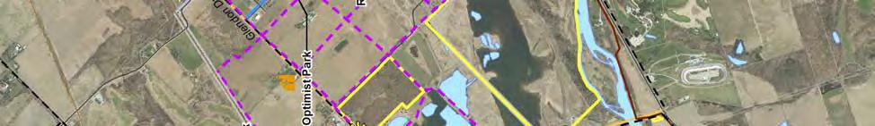
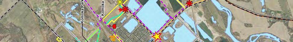


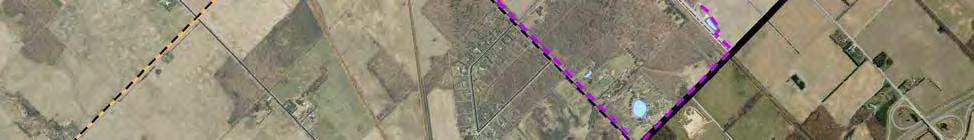
48 4.0 Trail Network Development Proposed Trail Routes Komoka-Kilworth monteith brown planning consultants 40


49 4.0 Trail Network Development Proposed Trail Route Poplar Hill / Coldstream monteith brown planning consultants 41
50 5.0 Trail Development Toolkit 5.0 Trail Development Toolkit 5.1 Design Standards & Guidelines This section of the Master Plan provides the technical requirements and standards for the construction of new trails and redevelopment of existing trails in the Municipality of Middlesex Centre. It should be noted that these standards only apply to recreational trails that are maintained by the Municipality and exclude wilderness trails, backcountry trails, portage routes, and trails used for motorized recreational vehicles, mountain biking, and cross-country skiing. These standards have been developed to conform to Ontario Regulation 413/12 under the Accessibility for Ontarians with Disabilities Act (2005) regarding the Design of Public Spaces Standards. This section is also based on standards prepared by the City of London, County of Brant, Region of York, and Ontario Traffic Manual. The Municipality shall refer to these guidelines for the construction of new and redeveloping trails, together with other guiding Provincial, County or Municipal construction documents. Given the varying terrain observed across the Municipality, it may not be reasonable to meet all standards and as a result, exceptions may be permitted. It is recommended that the Municipality consult with the Accessibility Advisory Committee for guidance regarding the design and construction of all future trails in Middlesex Centre Trails Trail Surfaces A range of trail surface types may be utilized as described in the recommended trail classification hierarchy, provided that they are firm and stable, and contain no tripping hazards. Recommended surface types include asphalt, concrete, limestone screening, or other firm and stable surface. Paving with asphalt or concrete is appropriate for highly developed areas and the use of woodchip surfaces should only be considered for woodland trails and sensitive areas. The trail surface may be selected at the discretion of the Municipality with consideration given to the trail hierarchy, trail type, location and resources available. Trail Width The width of trails in Middlesex Centre is subject to the classification system. A minimum width of 3,000 mm (3 m) shall be maintained along all primary trails as these multi-use routes accommodate the widest range of transportation modes and facilitate bi-directional movement with ease. Secondary and Tertiary trails shall maintain a minimum width of 1,800 mm (1.8 m). The entrance to a trail must have a minimum clear opening of 850 mm (0.85 m), whether the entrance includes a gate, bollard, or other entrance design. Vertical Height A minimum vertical clearance of 2,100 mm (2.1 m) above grade shall be maintained along all trail routes. Separation Zone / Buffer Separation zones should be provided to partition trail routes with competing activities or sensitive lands uses. A common concern raised among pedestrians is the unsafe feeling of sharing the right-of-way with vehicular traffic and are less likely to choose active forms of mobility. Separation zones physically remove pedestrians and trail users from vehicular traffic and establish a defined walking pathway. Communities typically establish a range of separation distances depending on the width of the right-of-way and can vary between 2,000 mm (2 m) and 6,000 mm (6 m). Wherever possible, the Municipality shall target a monteith brown planning consultants 42
51 5.0 Trail Development Toolkit minimum separation of 2,000 mm (2 m) from the vehicular travel lane or shoulders along County and local roads. In some cases, a ditch or swale may also serve as an acceptable separation zone. Recognizing that the target separation width may be a considerable deviation from existing conditions in addition to obstacles such as utilities and trees within the planned walking route, the Municipality shall exercise discretion in determining separation widths on a case-by-case basis. The Municipality shall also strive to achieve a minimum separation zone of 5,000 mm (5 m) in areas where a proposed trail route abuts the rear or side yard of residential properties and 2,000 mm (2 m) from all other land uses and property boundaries. This separation zone will provide a sufficient zone of separation to maintain privacy of residential properties. To further bolster the separation of uses, the Municipality shall consider the use of landscaping or vegetative buffering. Clearance Width A clearance width should be provided along all sides of trails to accommodate manoeuvrability and minimize intrusions along the walking path, such as hanging vegetation or signage. Clearance widths vary depending on the trail classification. A 1,000 mm (1 m) clearance width should be maintained along primary trails, 500 mm (0.5 m) along secondary trails, and 250 mm (0.25 m) along tertiary trails. Trail Cross and Running Slope The AODA does not identify specific guidelines for the slope of recreational trails, recognizing that the terrain may vary considerably across most routes. On a project-specific basis it is recommended that the Municipality consult with the Accessibility Advisory Committee for guidance on this matter. Trails along Railway Corridors The use of former railway lines as trails should be encouraged and opportunities for trails along low volume railway corridors should be explored provided that pedestrian safety is maintained. Trails along active railways may be located within the transportation corridor provided approval from the appropriate authority or adjacent to the corridor through land dedication in new development. In all instances, an appropriate separation buffer should be provided between the railway and pedestrian to enhance safety. The Municipality shall engage the appropriate transportation authorities to identify an appropriate separation distance as a part of the design and development of trails along active railway corridors (including railway crossings), as necessary. Boardwalks Boardwalks are typically raised pathways constructed over waterways or areas that experience continuous moisture such as marshes and wetlands. The following design regulations shall apply in for the construction of boardwalks: Minimum width of 1,000 mm (1.0 m) Minimum vertical clearance of 2,100 mm (2.1 m) Constructed with firm and non-slip materials No openings along the boardwalk greater than 20mm If the boardwalk is located adjacent to water or a drop-off, a curbed edge / edge protection shall be provided with a minimum height of 50 mm If a boardwalk has a slope greater than 1:20, it must be treated as a ramp monteith brown planning consultants 43
52 5.0 Trail Development Toolkit Ramps Ramps for recreation trails shall have regard for the following regulations: Minimum clear width of 900 mm (0.9 m) Height clearance of 2,100 mm (2.1 m) Firm and stable surface Running slope no greater than 1:10 for recreational trail ramps Landings must be provided o at top and bottom of all ramps o when there is a change in direction of ramp o at horizontal intervals not greater than 9,000 mm (9.0 m) apart Landings must be designed to a minimum of 1,670 mm (1.67 m) by 1,670 mm (1.67 m) wherever they are required to be provided Landings must have maximum cross slope of 1:50 Handrails must be included on both sides of the ramp and must: o Be continually graspable along the entire length of the ramp and have a circular crosssection with a minimum outside diameter of 30 mm and maximum outside diameter of 40mm, or any non-circular shape with a graspable portion that has a perimeter not less than 100 mm and not more than 155 mm and whose largest cross-sectional dimension is not more than 57 mm o Be 865 mm to 965 mm in height, measured vertically from the surface of the ramp o Terminate in a manner that will not obstruct pedestrian travel or create a hazard o Extend horizontally not less than 300 mm (0.3 m) beyond the top and bottom of the ramp o Be provided with clearance of not less than 50 mm between the handrail and any wall to which it is attached For ramps greater than 2,200 mm (2.2 m) in width: o One or more intermediate handrails which are continuous between landings must be provided and located so that there is no more than 1,650 mm between handrails The ramp must have a wall or guard on both sides and where a guard is provided, it must: o Be not less than 1,070 mm measured vertically to the top of the guard from the ramp surface o Be designed so that no member, attachment or opening located between 140 mm and 900 mm (0.9 m) above the ramp surface being protected by the guard will facilitate climbing The ramp must have the same edge protection as a boardwalk Trailheads Trailheads should be located at the key entrances to a recreational trail and also serve as locations for users to meet. Trailheads should be accessible, conveniently located in open areas and be highly visible. All existing and new trailheads should incorporate features including (but not limited to) parking, signage, seating, waste receptacles, washrooms, or other amenities identified by the Municipality. Where possible, trailheads should be located near community facilities to share existing amenities. monteith brown planning consultants 44

53 5.0 Trail Development Toolkit Signage Aligning with the Municipality s branding strategy, signage should be clear, consistent, and accessible, serving many purposes including, but not limited to: Identifying the name of the trail with the Municipality s logo to signify municipally-own lands. Providing information regarding trail length, surface, and difficulty, accompanied by a map. Identifying key points of interest along the trail. Identifying permitted uses (hiking, cycling, etc.). Describing rules pertaining to the use of the trail. Hours of operation. Effective signage plays an important role in the trail network as it attracts, guides, and directs users along designated pathways. Trail Signage can generally be categorized into six types, as described in greater detail below. Each signage type should be considered for the Municipality s existing and future trail routes. To ensure that signage is accessible, signage text shall have a high tonal contrast with its background and use a sans serif font style. Trailhead Trailhead signage must be provided at the primary entrance to each recreational trail, although there may be more than one trailhead for each trail. Trailhead signage should be located in highly visible areas that commonly serve as meeting places, located near parking, and be co-located with other amenities, features, or uses, or be located near a main or frequently traveled road. Trailheads must include the following information: trail length, type of surface, average and minimum trail width, average and maximum running slope and cross slope, and location of amenities where provided. Regulatory Signs Rules of the trail are generally located at all trailheads or all access points. These signs dictate the rules and law of the trail, which the user must abide by. These laws are typically enforced by provincial law or municipal by-law, and should be stated on the sign. Regulatory signage may also describe an assortment or rules, information, and conduct in which the user must follow, including permitted uses, hours of operation, trail etiquette, as well as key contact information should a user wish to report a hazard or unsafe use of the trail. Way-finding These signs provide users with a general overview of the trail including direction, length, key points of interest, settlement areas, and feature other key details. Way-finding signs should be displayed prominently at all access points to the trail and inform users of their current location. Interpretive Interpretive signs may serve as an opportunity to showcase information that relates to the trail and its environment. The information presented on the interpretive sign may vary and including, but not be limited to, the history of the trail or environment it is located in, native fauna and flora, or other historical, cultural, or environmental facts that may interest the user. While interpretive signs should be consistent with the Municipality s branding strategy, opportunities may exist to utilize some creative flair to the sign s design to generate excitement and interest. As a result, these signs should monteith brown planning consultants 45


54 5.0 Trail Development Toolkit be attractive and located in prominent areas such as at key points of interest, look-outs, or rest areas along the trail. Route Markers Route markers provide users with information pertaining to the distance from a specified reference point, typically to a key point of interest or trail head. Route markers should be located at regular intervals along the trail (e.g., 100 metres), although the interval may vary depending on the trail type. Warning Signs Warning signs should be displayed in the most visible locations to warn users of potentially hazardous areas due a range of possibilities that may include, but not be limited to, to uneven trail surfaces, or naturally occurring hazards from changing weather conditions. Example Signage Types for the Municipality of Middlesex Centre (Taken from the Middlesex Centre Branding Strategy) Source: Branding Middlesex Centre: A Strategy, 2012 monteith brown planning consultants 46
 washroom facilities shall be provided at the Municipality s discretion.")
55 5.0 Trail Development Toolkit Washrooms Where possible, the Municipality shall encourage the use of existing washroom facilities, particularly those located at existing community facilities and parks. The provision of permanent or temporary (i.e., portable) washroom facilities shall be provided at the Municipality s discretion. Regard shall be given to the Ontario Building Code and National Building Code for standards relating to the construction and design of accessible washrooms. Benches & Seating Benches and Seating areas are particularly important features for persons with disabilities as well as older adults and those with children. As such, convenient seating areas are key amenities that should be located along trail routes, but not within the walking path, as they provide opportunities for users to rest and enjoy the outdoors. Seating areas shall be located on firm, level surfaces in meaningful locations including (but not limited to) trailheads, along high traffic trail routes, areas with high visibility, and viewing points. To further visibility of seating areas, the design should give consideration to a high contrast to the walking path including colour, texture, and materials. To ensure that seating areas are accessible, the design of benches shall have regard for the following: Have back and arm rests Be designed with a contrasting colour to its surroundings Be located on a firm and stable surface that is a minimum of 920 mm x 1,370 mm in size Lighting Lighting shall only be provided in key areas identified by the Municipality. For example, lighting may be desirable along well-used trail routes, sidewalks along major roads, trails within park settings and public spaces, trailheads and seating areas, or trails that intersect with streets and present benefits such as increased visibility and deterring illicit activities. Lighting trails may not be appropriate for more secluded trails as lighting provides an illusion of safety and should not be used where safety concerns exist. When considering the installation of lights along trails or at trailheads, the municipality should consider safety, intensity of use, impact on adjacent uses (light pollution), costs, maintenance, and impact on the environment. Landscaping & Screening In many instances, the existing natural environment will provide ample landscaping and screening. However, there may be some cases in new trail construction that may require buffering such as in cases where a trail route abuts the rear of residential properties. The Municipality shall consider the use of landscaping or vegetative buffering to provide adequate screening and maintain residential privacy. Further, landscaping may also be considered in areas where shade is limited, such as in open spaces, or be co-located with other trail amenities such as benches and signage. Elements of landscaping and screening may also be considered in areas of new construction where trails are proposed, and should be included in reviews of proposed plan of subdivisions. Vegetation shall not be located within the traveled pathway and a vertical clearance of 2,100 mm shall be maintained. monteith brown planning consultants 47


56 5.0 Trail Development Toolkit Conceptual Trail Cross-Sections Example primary multi-use trail Example minimum trail clearance Example separation zone monteith brown planning consultants 48
57 5.0 Trail Development Toolkit Sidewalks Sidewalk Surface The preferred sidewalk surface shall be concrete or asphalt. Sidewalk Width Sidewalks located within settlement areas shall be physically separated from the road of travel with a grass boulevard or separation zone, although sidewalks adjacent to curbs are acceptable. In accordance with the Municipality s Infrastructure Design Standards, sidewalks shall have a minimum width of 1,500 mm (1.5 m) when a separation zone exists. Where a sidewalk directly abuts the road of travel, the minimum sidewalk width shall be 1,800 mm (1.8 m). Vertical Height A minimum vertical clearance of 2,100 mm (2.1 m) above grade shall be maintained along all sidewalks. Ramps Ramps for sidewalks shall have regard for the following regulations: Minimum clear width of 900 mm (0.9 m) Height clearance of 2,100 mm (2.1 m) Firm and stable surface Running slope no greater than 1:15 for Landings must be provided o at top and bottom of all ramps o when there is a change in direction of ramp o at horizontal intervals not greater than 9,000 mm (9.0 m) apart Landings must be designed to a minimum of 1,670 mm (1.67 m) by 1,670 mm (1.67 m) wherever they are required to be provided Landings must have maximum cross slope of 1:50 Handrails must be included on both sides of the ramp and must: o Be continually graspable along the entire length of the ramp and have a circular crosssection with a minimum outside diameter of 30 mm and maximum outside diameter of 40mm, or any non-circular shape with a graspable portion that has a perimeter not less than 100 mm and not more than 155 mm and whose largest cross-sectional dimension is not more than 57 mm o Be 865 mm to 965 mm in height, measured vertically from the surface of the ramp o Terminate in a manner that will not obstruct pedestrian travel or create a hazard o Extend horizontally not less than 300 mm (0.3 m) beyond the top and bottom of the ramp o Be provided with clearance of not less than 50 mm between the handrail and any wall to which it is attached For ramps greater than 2,200 mm (2.2 m) in width: o One or more intermediate handrails which are continuous between landings must be provided and located so that there is no more than 1,650 mm between handrails The ramp must have a wall or guard on both sides and where a guard is provided, it must: o Be not less than 1,070 mm measured vertically to the top of the guard from the ramp surface o Be designed so that no member, attachment or opening located between 140 mm and 900 mm (0.9 m) above the ramp surface being protected by the guard will facilitate climbing The ramp must have the same edge protection as a boardwalk monteith brown planning consultants 49

58 5.0 Trail Development Toolkit Sidewalk Cross and Running Slope Sidewalk cross and running slope should generally not exceed 1:20. If this is slope cannot be achieved, the slope should not exceed 1:10. Sidewalks may have a slope greater than 1:20 provided the slope is not greater than the slope of the adjacent roadway. Conceptual Sidewalk Cross-Sections Example urban sidewalk Example sidewalk with on-road cycle lane/paved shoulder Cycle Lanes In the absence of a County-wide cycling strategy, the following design considerations should be applied in Middlesex Centre, and supplemented by Provincial design guidelines for cycle lanes. There are a number of cycle lane solutions available to the Municipality and teamed with the appropriate signage recommended through the Municipality s Share the Road campaign, the provision of cycling infrastructure and greater awareness will maximize the safety of cyclists. On a case-by-case basis, the Municipality should consider one of the two following types of cycle lanes: Dedicated Cycle Lane A dedicated cycle lane physically removes cyclists from other motorists and provides users with designated lane exclusively for cyclists. These lanes are unidirectional and located on the right side of the lane, are commonly separated from vehicular traffic with pavement markings. The minimum width of a dedicated cycling lane shall be 1,800 mm (1.8 m) and should the Municipality consider monteith brown planning consultants 50

59 5.0 Trail Development Toolkit implementing bi-directional cycling lanes, the minimum width shall be 3,000 mm (3.0 m). Where available, cyclists should be encouraged to utilize paved road shoulders. Where space permits, paved shoulders should be provided alongside dedicated cycle lanes to provide cyclists with additional separation from vehicular traffic. Shared Roadway Bicycles are identified as vehicles under the Ontario Highway Traffic Act and as such, have a right to share the roadway with other vehicles. This type of cycling currently exists in the Municipality along roads without paved shoulders and that there are currently no dedicated cycling lanes. Pavement markings or Sharrows shall be clearly marked on all roadways that have been identified as a cycling route to notify both motorists and cyclists to share the road appropriately. Example sharrow zone 5.2 Policy Development Strengthening local land use policies is essential for advancing Middlesex Centre as an active transportation friendly community. The Municipality currently provides high level policies contained in the Official Plan that focus on the provision of trails; for example, Section 9.4 identifies support for improving active transportation methods and promotes the establishment of a municipal-wide trail system. OPA #28 also provides further support for trails and active forms of transportation within the Komoka-Kilworth settlement area, supported by a conceptual trail network that has been considered as a part of this Master Plan. A schedule of this Master Plan s recommended trail network should be included in the Official Plan to provide a framework for establishing the Municipality s active transportation network. This Master Plan is a significant leap forward to preparing a long term vision for a future active transportation network promoting a healthy and vibrant community. The Planning Act also encourages the provision of trails through Section 51, which allows Municipalities to require the dedication of pedestrian and bicycle pathways, parkland, and lands for other recreational purposes as a condition of draft plan of subdivision approval. While the existing Official Plan currently permits the dedication of lands for parkland and recreational activities, no policies exist regarding the acquisition of lands for trail and pathway development. To advance the trail network, it is recommended that the Municipality establish policies within the Official Plan that require subdivision and site plan proposals to include and identify lands for trail and pathway dedication. This policy would provide an opportunity for the Municipality to identify desired lands for monteith brown planning consultants 51
60 5.0 Trail Development Toolkit dedication, with consideration given to the recommended trail routes in this Master Plan. The guiding principles and Trail Development Toolkit contained in this Master Plan should also be referenced in the Official Plan. Future planning proposals should include the type and location of trails with supporting design details; the incorporation of pedestrian and bicycle infrastructure should also be encouraged. The Municipality may review the proposed trail routes to ensure that they are consistent with the guiding principles and trail design guidelines. It is common practice in other communities for municipalities to require developers to construct portions of trails and pathways within their subdivision, in addition to sidewalks. As part of new subdivision development, the Municipality should establish policies to require developers to fund and construct offroad trails and pathways that primarily serve the local development, including connections to Municipalwide and/or settlement area-wide trail networks. Development charges collected by the Municipality for trail development should be directed towards trails that form an integral part of the Municipal-wide and/or settlement area-wide networks. To minimize future residential concerns for trail development in newly developing areas, the Municipality should encourage developers to disclose future trail routes within the surrounding area or on adjacent properties to potential homeowners so they are well informed of future development plans prior to purchase. Developers should be encouraged to convey this information through a number of means such as subdivision renderings, information packets, and through the Purchase Agreement. To avoid conflicts with new residents, the Municipality should require developers to construct trail routes concurrently with the construction of community services, infrastructure, and homes. It is recognized that disclosing future trail routes in new areas does not apply to existing subdivisions or residents adjacent to new construction lands; however, it is recommended that the Municipality engage residents within these areas early in the process to inform them of trail development opportunities and solicit public opinions to consider in the planning approvals stage, emphasizing the importance and benefits trails provide to the neighbourhood to achieve community support. The Municipality should also investigate other opportunities to strengthen Official Plan policies to emphasize the commitment to active transportation planning and enhancing the trail network. Policies that may be considered include, but are not limited to: Where appropriate, all new and existing parks shall have a trail loop or connections to existing or future trail routes. The Municipality shall be permitted to acquire lands through dedication, easements, purchase, donation/bequests, or other means, for the purposes of enhancing the trail network. Where trails are located adjacent to residential areas, a buffer or landscaped screening shall be provided to preserve privacy. Where possible and feasible, utility corridors and former rail lines shall be incorporated into the trail network. monteith brown planning consultants 52
61 5.0 Trail Development Toolkit In addition, the Municipality shall consider policies that bolster the provision of pedestrian and bicycling movement including, but not limited to the following: For development within settlement areas, the provision of sidewalks shall be encouraged on at least one side of the street to promote walking and improve connectivity and mobility. Explore opportunities to provide sidewalks within existing developments. Provide pedestrian and/or cycling linkages to commercial and institutional uses, such as schools, to promote active transportation. Have regard for pedestrian connectivity and the Trails Master Plan in the review of development or redevelopment applications. Require cycling amenities, such as Share the Road signage and bicycle storage facilities, in appropriate areas to support new or existing cycling infrastructure. Develop a network of cycling routes though the guidance of the Trails Master Plan and in coordination with the County of Middlesex. Recommendations 7. Amend the Official Plan to integrate land dedication policies for pedestrian and bicycle pathways as a condition of draft plan of subdivision approval, with consideration given to the recommended trail network contained in this Master Plan. 8. Create policies requiring developers to fund and construct off-road trails and pathways that primarily serve the local development, including connections to Municipal-wide and/or settlement area-wide trail networks. 9. To serve as an awareness tool and framework for trail development, include the recommended trail network as a Schedule in the Official Plan. The Official Plan should also make reference to the guiding principles and Trail Development Toolkit. 10. Establish Official Plan policies that strengthen support for active transportation, trail development, and pedestrian and bicycle infrastructure. 11. Encourage developers to communicate information to potential homebuyers about future trail development within and adjacent to new residential development through means including brochures, information packages, subdivision renderings, and Purchase Agreements. 12. Inform the public of trail development in advance of construction to engage the public and provide opportunities for public input during the design process and to promote the social and environmental benefits of trails. monteith brown planning consultants 53
62 5.0 Trail Development Toolkit 5.3 Trail Management & Maintenance A Municipality s diligence in maintaining its trails is critical to ensuring user safety and to reduce exposure to any liabilities it may face. Effective inspection and maintenance measures can improve the provision of trails, decrease maintenance costs, and extend the lifecycle of trail surfaces if issues are identified and remediated in a timely manner. Ontario Trails suggests that trails should be designed with easy maintenance in mind to minimize future maintenance issues, which may include trail routing or the use of construction materials that are more durable and environmentally friendly, especially given the Municipality s climatic variations and naturally sensitive areas. Maintaining a clean and clear pathway is also essential to minimizing liability and protecting the Municipality s natural aesthetics. Grass-cutting and vegetation management along trails should be included as a part of the Municipality s existing grass maintenance program. Emptying waste receptacles along pathways should also be done at this time. Example Trail Inspection Checklist Source: Carlsbad Trail Maintenance Plan, 2002 While trail litter and debris is generally the responsibility of the Municipality, users and volunteer associations should also be encouraged to take ownership of the trail and assist with litter control and vegetation management. This can often be achieved through engaging partnerships with local community organizations and service clubs. Ontario Regulation 239/02 establishes that municipalities such as Middlesex Centre are required to undertake a sidewalk inspection on an annual basis. It is recommended that the Municipality undertake this sidewalk audit and extend this assessment to all existing and future trails identified in this Master Plan to ensure that access to high quality trails are available to users. This inspection should document trail surface and amenity conditions, deficiencies, safety concerns, vandalism, erosion, damages, or other factors that may prove to be a liability to the Municipality. Developing an inspection checklist (such as the one illustrated in the figure above) should be considered to ensure a thorough review of Municipal trails. It is recommended that the Municipality conducts this audit after the spring thaw, providing an optimal opportunity to identify damages or deficiencies and undertake repairs as necessary. Through this maintenance strategy, the Municipality should monitor the quality and condition of existing trails and identify improvements, as necessary, with regard for the design guidelines contained in this Master Plan. monteith brown planning consultants 54
63 5.0 Trail Development Toolkit Recommendations 13. Integrate grass-cutting and vegetation management measures along trails into the Municipality s existing grass maintenance program. 14. Conduct an annual inspection of Municipal trails and sidewalk, preferably after spring thaw to provide an optimal opportunity to identify damages or deficiencies and undertake repairs. 15. Monitor the quality and condition of existing trails and identify improvements, as necessary, with regard for the design guidelines contained in this Master Plan. 5.4 Risk Management and Liability Recognizing that safety is a guiding principle in the planning and selection of trail routes, minimizing risk of injury should be of upmost importance in the development of Middlesex Centre s trail network. While the Municipality is liable for any injury that may occur on publicly owned lands, ensuring that trail routes are appropriately designed, constructed, and maintained minimizes risk and offers the best protection against potential liability cases. As such, the Municipality should ensure that all existing and planned trails located on publicly-owned lands are appropriately managed and maintained in accordance with the directions and recommendations contained throughout this Master Plan or with other relevant Municipal maintenance policies. In addition to maintenance of Municipal trails, it is essential to educate users on safe trail etiquette. This can be achieved with the appropriate signage or other means of trail education (which is explored in the following section). Utilizing any of the six signage types described in the Trail Design Toolkit offers opportunity to communicate key safety information such as encouraging users to remain on designated pathways and report trail hazards or deficiencies, rather than attempting to address issues themselves to avoid injury to the user. Additionally, trail routes located on private lands often raises concerns from private landowners regarding liability impacts. While this concern is not only specific to Middlesex Centre, it is recognized that there are several undocumented and informal trail pathways that meander through rural and agricultural properties throughout the Municipality. It is anticipated that all trails recommended in this Master Plan will be established on public lands or within rights-of-way, although trail easements may be considered where necessary. The Occupiers Liability Act maintains that a person who enters the premises of lands for recreational activity shall be deemed to have willingly assumed all risks provided that no fee is paid for entry or activity and the person is not being provided with living accommodations. The occupier, defined as a person who is in physical possession of the premises or a person who has responsibility for and control over the condition of premises or the activities carried out on the premises, has no duty of care other than to not create a danger with deliberate intent of doing harm or damage to the person or person s property and to not act with reckless disregard of the presence of the person or the person s property. Given that it is unlikely that this information is known to landowners or trail users, it is recommended that the Municipality educate the public regarding this legislation to provide greater clarity on the roles and responsibilities of landowners around discussions on public access for trails on privately owned lands. monteith brown planning consultants 55
64 5.0 Trail Development Toolkit Recommendation 16. Ensure that Municipal trails are appropriately managed in accordance with the recommended maintenance strategies contained in this Master Plan, together with relevant Municipal maintenance policies. 5.5 Education & Promotion Promoting and educating the public on the use of trails is essential to ensuring that residents are aware of trails and how to use them safely. Raising awareness about Middlesex Centre s trail network through public outreach also promotes outdoor physical activities, social interaction, and healthy lifestyles. There are a number of tools that the Municipality can explore (either in partnership or alone) to encourage use of Municipal trails including, but not limited to, the following: Engage community groups and non-profit organizations to educate the public on trails located with the Municipality as well as general trail and cycling safety. Develop a mobile education station that can be used at community events such as the Ilderton Fair and Canada Day, etc. When not in use, this station can be displayed at a community facility or display case. Partner with local community groups to initiate a tree planting program along the trail network to promote the use of trails in Middlesex Centre, physical activity, team building and skill development, and encourage the community to take ownership of the surrounding environment. This program may also be eligible for students to obtain volunteer hours. Promote the responsibility of all residents to clean up the trail and report damages and deficiencies to the Municipality, rather than attempting repairs on their own. Trail Guide A Trail Guide is a vital tool to promoting the use of Municipal trails together with physical activity and outdoor leisure pursuits. Traditional trail guides vary in hardcopy form although many communities are providing trail guides electronically, either through the web or mobile applications. However, electronic guides do not replace hardcopy guides. A County-wide Trails Guide currently exists and is provided through Tourism Middlesex (in partnership with the Province, Middlesex-London Health Unit, Middlesex County, and other community partners). This map guide identifies the location, route and key information to trails within the Komoka Provincial Park and Coldstream Conservation Area and makes reference to the locations of the Ilderton Rail Trail and Weldon Park trails. The Municipality should engage Tourism Middlesex to update the Trails Guide to include other Municipal trails. Community Services Advisory Committee The Community Services Advisory Committee currently advises Municipal Council on issues relating to parks, recreation and trails in the Municipality. The Committee should continue to act as trail advocates and support the development of the Municipal trail network with regard for this Master Plan. The Committee may also oversee a number of educational and promotional initiatives to raise community awareness regarding the benefit and location of trails in Middlesex Centre. Additionally, the Advisory Committee can conduct research on a wide variety of trail topics including trends, policies, and best practices, within its role of providing trail-related expertise to Council to support decision making. monteith brown planning consultants 56
65 5.0 Trail Development Toolkit Cycling Safety and Share the Road Campaign A bicycle is considered as a vehicle under the Ontario Highway Traffic Act. In other words, cyclists have the same rights as responsibilities as other vehicles on the road. While the City of London boasts an established network of cycle lanes and infrastructure, numerous of cyclists from London and surrounding areas visit the rural landscapes of Middlesex Centre for their training or leisure needs. Given that there are no dedicated cycling lanes in the Municipality; cyclists must share the road with vehicular traffic. As a result, educating motorists and cyclists about cycling safety is paramount to encouraging cycling as a viable active transportation mode and leisure activity. The Share the Road Cycling Coalition was launched in 2008 with a mission to achieve three main goals: to enhance access for bicyclists on road and trails; improve safety for all bicycles; and educate citizens on the value and importance of safe bicycling for healthy lifestyles and communities. In 2013, a Share the Road signage project was initiated between the Middlesex-London Health Unit, the City of London, Middlesex County, and Middlesex Centre to provide Share the Road signage together with an education campaign to direct cyclists to safe and designated routes and to promote safe cycling and increased physical activity levels. It is recommended that the Municipality continue this partnership to promote safe cycling and give consideration to the cycling routes in the recommended trail network to identify potential locations for Share the Road signage. Engaging Children and Youth in Schools Partnering with the Thames Valley District School Board allows the Municipality to connect with local children and youth about the importance of physical activity in building a healthy community, particularly as children and youth represent the most vulnerable group affected by physical inactivity. Engaging children and youth through schools serves as an excellent opportunity to raise awareness about local trail network, trail etiquette, cycling safety, and also encourage active forms of travelling to school in programs provided through the Active & Safe Routes to School initiative (ASRTS). ASRTS is a community-based initiative that encourages non-motorized methods to school, thereby promoting active transportation choices and increased physical activity. There are a number of programs under the ASRTS initiative that the Municipality can employ to promote the use of trails together with physical activity including, but not limited to, Bike to School Day, Walk to School Month, and Walking School Bus. This initiative also encourages developing a School Travel Plan, which focuses on addressing challenges and identifying solutions to traveling to school. The Middlesex-London Health Unit has a wealth of resources on developing a Travel Plan for Middlesex Centre. It is recommended that the Municipality explore active transportation programming within schools under the ASRTS initiative. Consideration should be given to engaging the school board and community organizations through partnerships, which is explored in Section 6.3 of this Master Plan. Recommendation 17. Explore opportunities to promote trails in Middlesex Centre to raise awareness about the Municipal trail network, together with encouraging outdoor physical activity and educating the public on safe trail etiquette. Promotion or education strategies may be undertaken together with a community organization to leverage resources. monteith brown planning consultants 57
66 6.0 Implementation Strategy 6.0 Implementation Strategy This section summarizes the recommendations put forth within this Master Plan, along with their suggested priorities, timing, and high level costs (where applicable). This implementation strategy provides guidance for ensuring that the most critical success factors are dealt with in a timely fashion, while the less critical (yet important) recommendations are implemented over time. 6.1 Trail Phasing Ideally, the proposed trail network would be implemented immediately. However, municipalities are constrained by available resources and must strategically plan for the construction, replacement and maintenance of new and existing trails. As identified throughout this Plan, trails are an integral part of a healthy and sustainable community. The provision of a well planned trail network ensures that linkages are provided to key destinations, promoting the use of non-motorized and active forms of transportation, while recognizing those without access to a vehicle. In order to assist the Municipality in the provision of an effective trail network, this section identifies the timing and phasing for each proposed trail in Middlesex Centre based on short, medium, and long-term priorities. Trails that have been identified as short-term trails are those that are located in high demand areas as identified by staff and the public, as well as those within various stages of the land development process. The timing of constructing or expanding each trail proposed in the trail network is organized as follows: Short-term (1-5 years) 2014 to 2019 Medium-term (6-15 years) 2020 to 2029 Long-term (beyond 16 years) A variety of factors may require the Municipality to adjust project costing, funding, or timing. For example, budget pressures, timing of residential development, coordination with public works or roadway projects, availability of volunteers or resources, and other factors may impact implementation of the proposed recommendations. Due to limited staff resources, it is not possible for all recommendations to be implemented immediately. The Municipality should reconcile the recommendations with its fiscal capacity and focus on the highest priority items. It bears noting that the recommendations are based upon what is needed and not necessarily what is financially achievable by the Municipality at the present time. The full implementation of this Plan may require the pursuit of external funding opportunities and partnerships that are more fully discussed later in this Section. Recommendation 18. Implement the recommended trail network as opportunities allow, with reference to the proposed phasing. Modifications to trail phasing may be required to recognize budget pressures, timing of residential development, coordination with public works or roadway projects, availability of volunteers or resources, and other key factors. monteith brown planning consultants 58
67 6.0 Implementation Strategy Trail Phasing Municipal Wide monteith brown planning consultants 59


68 6.0 Implementation Strategy Trail Phasing Arva monteith brown planning consultants 60

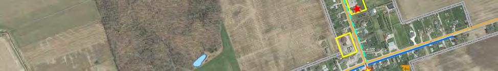


69 6.0 Implementation Strategy Trail Phasing Bryanston monteith brown planning consultants 61
70 6.0 Implementation Strategy Trail Phasing Delaware monteith brown planning consultants 62


71 6.0 Implementation Strategy Trail Phasing Denfield monteith brown planning consultants 63


72 6.0 Implementation Strategy Trail Phasing Ilderton monteith brown planning consultants 64
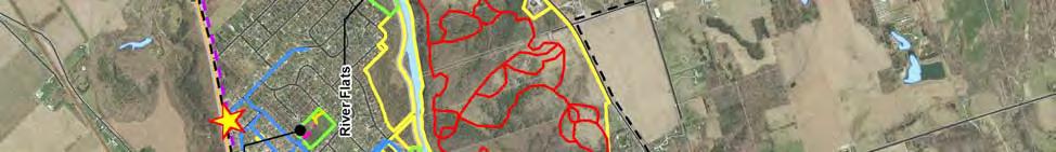

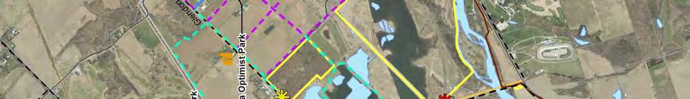


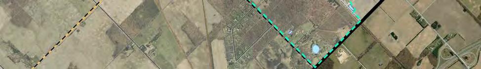
73 6.0 Implementation Strategy Trail Phasing Komoka-Kilworth monteith brown planning consultants 65


74 6.0 Implementation Strategy Trail Phasing Poplar Hill / Coldstream monteith brown planning consultants 66
75 6.0 Implementation Strategy 6.2 Trail Acquisition Strategies Much of the proposed trail network requires access through non-municipally owned lands as well as agricultural lands within settlement areas that will one day become developed. As a result, the Municipality should be armed with a number of acquisition strategies to implement the trail network proposed in this Plan. There are a number of formal and informal mechanisms that can be applied in the acquisition of lands for the purposes of establishing and enhancing the Municipality s trail network. Informal strategies to acquiring lands for trail purposes, such as verbal agreements, should be discouraged as a number of challenges may arise with regard to access, trail routing, safety and liability; although it is recognized that several informal trails exist throughout the Municipality. It is recommended that Middlesex Centre exercise the following acquisition tools to acquire future trail lands, many of which are supported by the Municipal Act and the Planning Act. It should be noted that each tool is unique and should be applied on a situational basis. Easement Securing an easement with a property owner gives the Municipality the right to use lands for a specified activity without purchasing the lands. This method is typically used to protect conservation or heritage lands as governed by the Conservation Lands Act and the Ontario Heritage Act. This formal agreement is registered on the title of the property and the right to access the lands remains through the length of the agreement should the ownership of the property change. This low cost strategy may ensure public access and provide flexibility in the use of lands. Land Purchase This strategy allows the Municipality to purchase all or a portion of lands at fair market value. Although this strategy ensures protection for public access, it can be financially challenging to purchase all privately-owned lands that lie within the recommended trail network. The land owner must be a willing seller and an agreeable purchase price must be identified. Land Exchange The Municipality may make an exchange of lands with a private land owner for lands that lie within the proposed trail route. While this strategy will guarantee public access, the lands proposed to be exchanged must be agreeable to both parties. Land exchanges are typically based on the appraised value, not the size of land. Right of First Refusal The Right of First Refusal is an agreement established by the Municipality and the landowner that grants the Municipality an opportunity to match another party s offer to purchase a specific property. This agreement may not give the Municipality immediate access to the lands but provides a chance to purchase at a later date as well as discourage competition from other potential buyers. Dedication through Plan of Subdivision Supported by Section 51 of the Planning Act, this strategy allows the Municipality to require the dedication of lands for pedestrian and bicycle pathways as a condition of draft subdivision approval and ensures protection of trail lands within settlement areas. This acquisition strategy will prove to be most appropriate in developing settlement areas, particularly in Ilderton and Komoka-Kilworth. monteith brown planning consultants 67
76 6.0 Implementation Strategy Donation or Bequest of Land The Municipality may accept a donation of land from a land owner, at which point the land owner receives a tax receipt at an appraised value for their charitable donation, provided the donation meets the requirements under the Federal Income Tax Act. This strategy is typically used for the donation of environmentally sensitive lands as a part of the Ecogifts Program, while donations outside of this program are subject to capital gains. Alternatively, landowners may choose to bequeath lands to the Municipality after death, which is more advantageous from a tax perspective. Lease/License Private Lands Similar to an easement, the Municipality may enter into a lease or license agreement with a landowner to establish public access through private lands. By contrast, this form of agreement does not bind future land owners and as a result, public access is not guaranteed. This option should generally be discouraged. Recommendation 19. Utilize a range of acquisition strategies to secure non-municipal lands for trail development. 6.3 Partnerships With an active abundance of local community partners, the Municipality should continue to build upon its existing relationships and form new ones with local organizations, agencies, businesses, and service clubs who have an interest in trails, active transportation, and the betterment of Middlesex Centre. Bolstered by the growing importance of active transportation and its link to health and wellness, there is a strong community interest in assisting with enhancing Middlesex Centre s trail network. When forming partnerships, it is necessary to establish mutually agreed upon roles and responsibilities through a formal partnership agreement. Roles and responsibilities may differ from one agreement to the next, depending on the abilities and resources of groups involved. For example, many service groups identified a willingness to participate in assisting with the provision and maintenance of trails in Middlesex Centre. Some may be interested in assisting with raising funds, while others would be willing to assist with construction and maintenance. A number of partnership opportunities exist, which vary in form as described throughout this Master Plan. Such opportunities may include, but not be limited to jointly produced promotional materials or educational programs within schools. Opportunities may also exist to assist with developing or constructing trails with manpower, monetary assistance, or the donation of amenities such as benches and waste receptacles. Examples of such partnerships between the Municipality and community partners have been recognized and it is recommended that the Municipality explore similar ventures to ensure the successful development and viability of the trails network. Gaining the support and buy-in of Middlesex County is also paramount to successfully building an interconnected trail network in Middlesex Centre. Through the consultation process, the County expressed support for active transportation choices and provides a wealth of resources in the design and construction of pedestrian and cycling routes. It is recommended that the Municipality coordinate with the County on active transportation efforts, such as a County-wide cycling strategy that has regard to the potential cycling routes identified in this Master Plan. monteith brown planning consultants 68
77 6.0 Implementation Strategy Recommendations 20. Continue to build upon existing relationships and form new ones with local organizations, agencies, and service clubs who have an interest in trails, active transportation, and the betterment of Middlesex Centre. 21. When forming partnerships, enter into formal agreements to identify roles and responsibilities based on the abilities and resources of groups involved. 6.4 Capital Cost Estimates An estimate of construction costs have been developed to provide a high level overview of the capital costs required for realizing the recommend trail network. These costs should be used to identify long term financial planning needs and should not be considered as absolute costs. Detailed costs should be identified through the design and construction process and confirmed by the Municipality. Actual costs may change over the life of this Master Plan; costs have not account for inflationary factors. Costs for benches, waste receptacles, signage, and other supporting amenities described in this Master Plan have not been calculated. Estimates also exclude costs to purchase non-municipal lands and acquire easements, in addition to trails proposed along the City of London utility pipeline and trails within the Coldstream Conservation Area as it is expected that the construction of these trails be led by other partners. Proposed routes in undeveloped settlement areas have also been excluded as these are anticipated to be constructed by the developer through condition of draft plan of subdivision approval and development agreements. Summary of Capital Cost Estimates for Implementing the Municipal Portion of Proposed Trail Network Cost $/m Short Term ( ) Medium Term ( ) Long Term (2030+) Distance (m) Sub-Total Distance (m) Sub-Total Distance (m) Sub-Total Primary Trail $ $36,320 0 $0 9,199 $1,471,840 Secondary Trail $75 1,835 $137,625 5,007 $375,525 9,152 $686,400 Sidewalk $150 2,036 $305,400 7,938 $1,190,700 2,124 $318,600 Tertiary Trail $75 4,107 $308,025 2,024 $151, $22,950 Total 8,205 $787,370 14,969 $1,718,025 20,781 $2,499,790 Exclusions: 18,514m of secondary trail and sidewalks proposed to be completed by developers in undeveloped settlement area lands. 1,496m of tertiary trail proposed within the Coldstream Conservation Area. Land acquisition and inflation. As summarized in the previous table, the total cost for implementing the municipal portion of the proposed trail network is approximately $5 million. The short term costs ( ) are estimated to be nearly $0.8 million and mainly consist of secondary sidewalks within established urban areas and tertiary trails within municipal parkland. The medium term costs ( ) are estimated to be $1.7 million for the construction of secondary sidewalks/trails and tertiary trails. Long term costs are estimated to be $2.5 million, which primarily includes the development of the Ilderton Rail Trail extension. monteith brown planning consultants 69
78 6.0 Implementation Strategy Recommendation 22. Establish an annual capital allocation within the Municipal budget for the construction of trail infrastructure. 6.5 Operating Cost Estimates The operating costs associated with trail infrastructure are difficult to estimate as they will vary by maintenance standards, ease of access, design and construction materials, age of trail, supporting amenities, volunteer participation, and other factors. Maintenance efforts may include removal of debris and trash, grass cutting and vegetation management, drainage, remediation, repairs to trail surfaces, fixtures, and trail heads. Municipalities report a wide range of annual maintenance costs, which generally range from $500 to $5,000 or more per kilometre. The lower end of this range is generally associated with low volume rural routes, while the higher cost would be more applicable to wider corridor multi-use trails in urban areas and parks. It is anticipated that a figure near the lower end of the spectrum could be applied to off-road trails (excluding sidewalks) in Middlesex Centre, with the potential to be partially offset through volunteer efforts and economies of scale within the Municipality s existing operating resources. As new trails are developed or extended, the Municipality should adjust the annual maintenance budget in proportion to the network s growth. However, as usage on key trail components increases coupled with a gradual deterioration of condition it is likely that maintenance costs will increase over time. It should be noted that the lifecycle for many trail surfaces and amenities is years; sufficient reserve funds should be allocated for rehabilitation (note: rehabilitation costs are not included in the Master Plan s capital cost estimates). Recommendation 23. Monitor the annual operational costs to establish an annual maintenance budget and adjust the budget in proportion to the trail network s growth. 6.6 Potential Funding Sources Several funding and grant opportunities exist at all levels of governance to help offset taxpayer cost. Recognizing the importance of protecting our environment and investing in infrastructure, a number of funding programs are available to support the provision of trails and active transportation related initiatives in Middlesex Centre. Some of the potential funding sources are described below, although this is not a comprehensive list as future federal/provincial stimulus opportunities emerge. Federal Federal/Provincial Gas Tax Fund Collected from the sale of fuel, every municipality in Canada receives a portion of the Gas Tax Fund for infrastructure projects that contribute to cleaner air, water, and greenhouse gas emissions. monteith brown planning consultants 70
79 6.0 Implementation Strategy Green Municipal Fund The Green Municipal Fund provides funding and a variety of resources to municipalities for a range of environmental plans, studies, and projects with regard for improving brownfields, energy, transportation, waste and water. Building Canada Fund To address national, regional, and local infrastructure priorities, the Building Canada Fund focus on building a stronger economy, a cleaner environment, and strong and prosperous communities. This initiative provides funding to communities for projects related to highways, public transit, drinking water, wastewater, connectivity and broadband, and innovation. Provincial Ontario Trillium Foundation The Ontario Trillium Foundation funds a variety of groups and initiatives that work to enhance the quality of life of residents across Ontario. Municipal Development Charges Many communities accept development charges for the development of trails and pathways. The Municipality s 2009 Development Charges Background Study and By-Law ( ) currently does not accept funds for trail and pathway construction, although it does accept monies for major indoor recreation facility/library/administration services and parkland development, which may also include trails within parkland. While this Master Plan recommends that the construction of local trails in new subdivisions be the developer s responsibility, the Municipality may collect development charges for the development of a Municipal-wide and/or settlement area-wide trail network. It is recognized that a new Development Charges By-Law is currently being prepared that will allow the Municipality to provide this asset. Trails & Sidewalks in New Development Emerging from recommendations of this Master Plan, enhanced Official Plan policies will require the construction and dedication of land for pedestrian and bicycling pathways through conditions for draft plan of subdivision approval and development agreements, thereby costs to the Municipality are minimized. However, the operational costs for any portion of trail or sidewalk assumed thereafter are the responsibility of the Municipality. Donations & Contributions Monetary or other resource donations and contributions from businesses and private groups, service clubs, and residents often serve as a local connection to enhancing community ties and should be encouraged to promote a sense of ownership and pride. The strength of local service and volunteer groups is often showcased in projects focused on the betterment of Middlesex Centre. Recommendation 24. Pursue outside funding sources in addition to local level opportunities for the development and maintenance of trails. monteith brown planning consultants 71

80 6.0 Implementation Strategy 6.7 Monitoring & Updating The Municipality should regularly review and assess the recommendations contained in this Master Plan. This will involve conducting an annual review of the recommended trail network and if necessary, periodically revise priorities based on new information, capital projects, and other opportunities, to ensure that this Plan remains reflective of current realities and resources, and responsive to the changing needs of the community. The following tasks should be considered to when monitoring and updating this Master Plan: Prepare an annual staff report to Council on the status of the implementation strategy, including completed trail projects, partnerships, newly acquired lands, funding, and planning trail development goals to be accomplished in the coming year. Undertake a full update to the Master Plan in five to 10 years. This update should include a consultation process to solicit public and stakeholder input. Recommendations 25. Prepare an annual staff report to Council on the status of the implementation strategy, including completed trail projects, partnerships, newly acquired lands, funding, and planning trail development goals to be accomplished in the coming year. 26. Undertake a full update to the Master Plan in five to ten years. This update should include a consultation process to solicit public and stakeholder input. monteith brown planning consultants 72
BACKCOUNTRY TRAIL FLOOD REHABILITATION PROGRAM
 BACKCOUNTRY TRAIL FLOOD REHABILITATION PROGRAM Backcountry Trail Flood Rehabilitation A June 2013 Flood Recovery Program Summary In June 2013, parts of Southern Alberta were devastated from significant
Committee. Presentation Outline
 CW-33-15 11/9/2015 Community and Corporate Services Committee November 10, 2015 1 Presentation Outline Background Vision and Objectives Study Process and Timeline Public and Stakeholder Engagement Organization
Blueways: Rivers, lakes, or streams with public access for recreation that includes fishing, nature observation, and opportunities for boating.
 Parks, Open Space and Trails PRINCE WILLIAM COUNTY 2008 COMPREHENSIVE PLAN TRAILS PLAN CONTENTS The components of the trails plan are: Intent Definitions Goals, Policies, and Action Strategies Trails Map
3.0 LEARNING FROM CHATHAM-KENT S CITIZENS
 3.0 LEARNING FROM CHATHAM-KENT S CITIZENS An important aspect in developing the Chatham-Kent Trails Master Plan was to obtain input from stakeholders and the general public. Throughout the course of the
Airport Planning Area
 PLANNING AREA POLICIES l AIRPORT Airport Planning Area LOCATION AND CONTEXT The Airport Planning Area ( Airport area ) is a key part of Boise s economy and transportation network; it features a multi-purpose
Chapter 6: POLICY AND PROCEDURE RECOMMENDATIONS
 Chapter 6 POLICY AND PROCEDURE RECOMMENDATIONS FOR SRRA Below are seven policy elements that should be considered for adoption by the Southwest Regional Recreation Authority of Virginia: 1. Develop strategies
City of Durango 5.8 FUNDING TRAILS DEVELOPMENT
 5.8 FUNDING TRAILS DEVELOPMENT The City has been successful in establishing dedicated local funding sources as well as applying for grants to develop the City s trail system, having received nearly $2.4
PSP 75 Lancefield Road. Northern Jacksons Creek Crossing Supplementary Information
 PSP 75 Lancefield Road Northern Jacksons Creek Crossing Supplementary Information September 2017 The northern crossing of Jacksons Creek proposed within the Lancefield Road PSP is a key part of the ultimate
2.1 TITLE: VMC PARKS MASTER PLAN AND IMPLEMENTATION STRATEGY PROJECT UPDATE
 2.1 Item: VMC Sub-committee Report DATE: Tuesday, June 12, 2018 WARD: 4 TITLE: VMC PARKS MASTER PLAN AND IMPLEMENTATION STRATEGY PROJECT UPDATE FROM: Jason Schmidt-Shoukri, Deputy City Manager, Planning
Those with Interest in the City of Cambridge Trail System
 Community Services Department City Hall 50 Dickson Street, P.O. Box 669 Cambridge ON N1R 5W8 Tel: 519-740-4681 July 20, 2010 To: Re: Those with Interest in the City of Cambridge Trail System City of Cambridge
A Master Plan is one of the most important documents that can be prepared by an Airport.
 The Master Plan A Master Plan is one of the most important documents that can be prepared by an Airport. A Master Plan is a visionary and a strategic document detailing planning initiatives for the Airport
CHAPTER 5. Chapter 5 Recreation Element
 CHAPTER 5 Recreation Element Chapter 5 Recreation Element The Recreation Element of the Meyers Area Plan is a supplement to the Recreation Element of the TRPA Regional Plan and the El Dorado County General
2. Goals and Policies. The following are the adopted Parks and Trails Goals for Stillwater Township:
 D. PARKS AND TRAILS 1. Introduction Stillwater Township s population is relatively low, with most residents living on rural residences on large lots. The need for active park space has been minimal in
Longmont to Boulder Regional Trail Jay Road Connection DRAFT FINAL REPORT
 Longmont to Boulder Regional Trail Jay Road Connection DRAFT FINAL REPORT December 2018 Project Summary Boulder County, Colorado, in partnership with the City of Boulder, is evaluating options for multi-use
Georgetown-Lewes Rail/Trail Study. Rail/Trail Study: Cool Spring to Cape Henlopen State Park New Road Extension (House Resolution No.
 Georgetown-Lewes Rail/Trail Study Rail/Trail Study: Cool Spring to Cape Henlopen State Park New Road Extension (House Resolution No. 47) August 22, 2011 Presentation Outline Background Benefits Statewide
Section II. Planning & Public Process Planning for the Baker/Carver Regional Trail began in 2010 as a City of Minnetrista initiative.
 Section II Planning & Public Process Planning for the began in 2010 as a City of initiative. city staff began discussions with the Park District on the possibility of a north/south regional trail connection
Logo Department Name Agency Organization Organization Address Information 5700 North Sabino Canyon Road
 Logo Department Name Agency Organization Organization Address Information United States Forest Coronado National Forest 5700 North Sabino Canyon Road Department of Service Santa Catalina Ranger District
Parkland County Municipal Development Plan Amendment Acheson Industrial Area Structure Plan
 Parkland County Municipal Development Plan Amendment Acheson Industrial Area Structure Plan New Plan Acheson Industrial Area Structure Plan Amendment Parkland County Municipal Development Plan Board Reference
Criddle/Vane Homestead Provincial Park. Management Plan
 Criddle/Vane Homestead Provincial Park Management Plan 2 Criddle/Vane Homestead Provincial Park Table of Contents 1. Introduction... 3 2. Park History.... 3 3. Park Attributes.... 4 3.1 Natural.... 4 3.2
MUNICIPALITY OF ANCHORAGE
 MUNICIPALITY OF ANCHORAGE ANCHORAGE PARKS & RECREATION Memorandum PRC 08-56 DATE: 5 August 2008 TO: FROM: SUBJECT: Parks & Recreation Commission Holly Spoth-Torres, Park Planner PRC 08-56 Far North Bicentennial
Strategic Objectives, Initiatives and Actions
 Strategic Objectives, Initiatives and Actions The following Strategic Objectives and the associated Initiatives and Actions for each have been developed to meet the challenges associated with trail development
2016 Regional Transportation Alternatives Program (TAP) Grant Application
 Grant Application") 2016 Regional Transportation Alternatives Program (TAP) Grant Application PROJECT TITLE: Yelm-Tenino Trail Extension Feasibility Study TRPC use only GENERAL PROJECT INFORMATION Agency or Organization City
2016 Regional Transportation Alternatives Program (TAP) Grant Application PROJECT TITLE: Yelm-Tenino Trail Extension Feasibility Study TRPC use only GENERAL PROJECT INFORMATION Agency or Organization City
DATE: 23 March, 2011 TO: Communities FROM: BlazeSports America. RE: Accessible Trails Checklist 1
 M E M O R A N D U M DATE: 23 March, 2011 TO: Communities FROM: BlazeSports America RE: Accessible Trails Checklist 1 The purpose of the Accessible Trails Checklist (below) is to help the community review
RUSHMORE CONNECTOR TRAIL PROPOSAL
 PURPOSE AND NEED Background The U.S. Forest Service, Black Hills National Forest (Forest Service) has received a special use permit application from the State of South Dakota Department of Game, Fish and
Port Bruce. Interim Management Statement
 Port Bruce Interim Management Statement Port Bruce Interim Management Statement August 3, 1999 This Port Bruce Provincial Park Interim Management Statement provides direction for the custodial management
Proposal to Redevelop Lower Kananaskis River-Barrier Lake. Bow Valley Provincial Park. Frequently Asked Questions
 Proposal to Redevelop Lower Kananaskis River-Barrier Lake Bow Valley Provincial Park Frequently Asked Questions What is being proposed? What are the details of the proposal? Where is the project area located?
1.0 BACKGROUND NEW VETERANS CHARTER EVALUATION OBJECTIVES STUDY APPROACH EVALUATION LIMITATIONS... 7
 New Veterans Charter Evaluation Plan TABLE CONTENTS Page 1.0 BACKGROUND... 1 2.0 NEW VETERANS CHARTER EVALUATION OBJECTIVES... 2 3.0 STUDY APPROACH... 3 4.0 EVALUATION LIMITATIONS... 7 5.0 FUTURE PROJECTS...
Welcome to the future of Terwillegar Park a Unique Natural Park
 Welcome to the future of Terwillegar Park a Unique Natural Park 1 Introduction The Terwillegar Park Concept Plan study will develop an overall concept plan, management objectives and development guidelines
PEMBERTON VALLEY RECREATIONAL TRAILS MASTER PLAN UPDATE Community Open House. April 2018
 PEMBERTON VALLEY RECREATIONAL TRAILS MASTER PLAN UPDATE Community Open House April 2018 Introductions Introductions Matt Bakker, BHA Project Coordinator Other Team Members: Liz Scroggins, Grey Owl Consulting
Outdoor Developed Areas
 The United States Access Board is an independent federal agency that promotes equality for people with disabilities through leadership in accessible design and the development of accessibility guidelines
What s covered. What s not covered. Options for those not covered. ABA Coverage
 The United States Access Board is an independent federal agency that promotes equality for people with disabilities through leadership in accessible design and the development of accessibility guidelines
MEDIUM SIZE STADIUM STRATEGY
 MEDIUM SIZE STADIUM STRATEGY Approved by City Council on March 12, 2014 This plan is available online at www.edmonton.ca I. Executive Summary... 4 II. Medium Size Stadium Strategy... 5 1. Background...
Appendix 3. Greenway Design Standards. The Whitemarsh Township Greenway Plan
 Appendix 3 Greenway Design Standards This chapter discusses two design standards for the greenway types discussed above. First, trail design standards are presented together with trailhead facilities and
Gold Coast. Rapid Transit. Chapter twelve Social impact. Chapter content
 Gold Coast Rapid Transit Chapter twelve Social impact Chapter content Social impact assessment process...235 Existing community profile...237 Consultation...238 Social impacts and mitigation strategies...239
Establishing a National Urban Park in the Rouge Valley
 STAFF REPORT ACTION REQUIRED Establishing a National Urban Park in the Rouge Valley Date: March 29, 2012 To: From: Wards: Reference Number: Executive Committee Deputy City Manager, Cluster B All p:\2012\cluster
Brampton, Ontario REQ. no.: PLANNING, DESIGN & DEVELOPMENT COMMITTEE
 ftorontoand REGION rv~ Conservation for The Living City May 22,2009 2I22V,5L CFN 42397 CLERK S DEPT. Mr. Peter Fay City Clerk, City of Brampton MAY 2 7 2008 2 Wellington Street West Brampton, Ontario REQ.
Land Management Summary
 photo credit: ANGAIR Anglesea Heath Land Management Summary The Anglesea Heath (6,501 ha) was incorporated into the Great Otway National Park in January 2018. This provides an opportunity to consider the
Strengthening the Ontario Trails Strategy. Report on Consultations and the Environmental Bill of Rights Registry
 Strengthening the Ontario Trails Strategy Report on Consultations and the Environmental Bill of Rights Registry Purpose To report on the feedback and information received through the regional consultations,
MINISTRY OF TOURISM AND RECREATION
 THE ESTIMATES, 2005-06 1 SUMMARY The Ministry of Tourism and Recreation plays a central role in rebuilding the province's pride and economic prosperity. Its key activities directly support the achievement
REGION OF WATERLOO INTERNATIONAL AIRPORT AIRPORT MASTER PLAN EXECUTIVE SUMMARY MARCH 2017
 REGION OF WATERLOO INTERNATIONAL AIRPORT AIRPORT MASTER PLAN EXECUTIVE SUMMARY MARCH 2017 Contact: Chris Wood, Airport General Manager cwood@regionofwaterloo.ca (519) 648-2256 ext. 8502 Airport Master
Preferred Recreation Recommendations Stemilt-Squilchuck Recreation Plan March 2018
 Preferred Recreation Recommendations Stemilt-Squilchuck Recreation Plan March 2018 Below are the recommended recreation ideas and strategies that package together the various recreation concepts compiled
CHAPTER 9. PARKS, RECREATION, TRAILS AND NATURAL AREA RESOURCES
 CHAPTER 9. PARKS, RECREATION, TRAILS AND NATURAL AREA RESOURCES The forms of recreation chosen by residents and visitors in the CBJ are as diverse as the population. Many people choose to recreate in developed
Proposal to Redevelop Lower Kananaskis River-Barrier Lake. Bow Valley Provincial Park
 Frequently Asked Questions Proposal to Redevelop Lower Kananaskis River-Barrier Lake Bow Valley Provincial Park Frequently Asked Questions What has been decided? What are the details of the plan? What
3. COLTA / HUGA CONNECTIONS - PRELIMINARY
 9 3. COLTA / HUGA CONNECTIONS - PRELIMINARY 3.1 COLTA The Chain of Lakes Trail Association (COLTA) trail, formerly identified as the Chester Spur Line, was completed and opened for use in June 2011. The
Chapter 6. Action Program. Heart of the Lakes Area Recreation Plan
 Heart of the Lakes Area Recreation Plan 1. Design and construct the following trails (please see the following map): a. the Speedway Trail 1) primary pathway the main trail 2) secondary pathway the proposed
Criddle/Vane Homestead Provincial Park. Draft Management Plan
 Criddle/Vane Homestead Provincial Park Draft Management Plan 2 Criddle/Vane Homestead Provincial Park Table of Contents 1. Introduction... 3 2. Park History.... 3 3. Park Attributes.... 3 3.1 Natural....
FEASIBILITY CRITERIA
 This chapter describes the methodology and criteria used to evaluate the feasibility of developing trails throughout the study areas. Land availability, habitat sensitivity, roadway crossings and on-street
Continental Divide National Scenic Trail Legislative History and Planning Guidance
 Continental Divide National Scenic Trail Legislative History and Planning Guidance Legislation, Policy, and Direction Regarding National Scenic Trails The National Trails System Act, P.L. 90-543, was passed
Discussion Paper: Development of a Plan for Trails on Public Land
 Discussion Paper: Development of a Plan for Trails on Public Land APRIL 2017 The purpose of this Discussion Paper is to summarize the status & issues relating to District trails and feedback to date, and
The Corporation of the City of Kawartha Lakes Council Report
 The Corporation of the City of Kawartha Lakes Council Report Report Number ENG2017-008 Date: September 12, 2017 Time: 2:00 p.m. Place: Council Chambers Ward Community Identifier: All Subject: Author Name
China Creek North Park Upgrades and Glen Pump Station. Park Board Committee Meeting Monday, July 10, 2017
 China Creek North Park Upgrades and Glen Pump Station Park Board Committee Meeting Monday, July 10, 2017 Purpose The purpose of this presentation is to: Share the results of the public engagement processes;
Item No Halifax Regional Council April 10, 2018
 P.O. Box 1749 Halifax, Nova Scotia B3J 3A5 Canada Item No. 14.3.2 Halifax Regional Council April 10, 2018 TO: SUBMITTED BY: Mayor Savage and Members of Halifax Regional Council Original Signed Councillor
Economic Development and Tourism
 SECTION 4 SECTION 4 Economic Development and Tourism 4. Economic Development and Tourism Tourism plays a very important role in Niagara s economy, providing employment and generating business for support
DRAFT - APRIL 13, 2007 ROUTING STUDY FOR TRAIL CONNECTIONS BETWEEN CALAIS AND AYERS JUNCTION
 DRAFT - APRIL 13, 2007 ROUTING STUDY FOR TRAIL CONNECTIONS BETWEEN CALAIS AND AYERS JUNCTION Abstract The vision for the East Coast Greenway is an off-road urban trail system running from Calais, Maine
POLICY & STRATEGIES The Vancouver Park Board approves major changes in Vancouver parks, including the design and development of parks.
 September 8, 2017 TO: Park Board Chair and Commissioners FROM: General Manager Vancouver Board of Parks and Recreation SUBJECT: Brewers Park and Clinton Park Renewal Concept Plans RECOMMENDATION THAT the
JOSLIN FIELD, MAGIC VALLEY REGIONAL AIRPORT DECEMBER 2012
 1. Introduction The Federal Aviation Administration (FAA) recommends that airport master plans be updated every 5 years or as necessary to keep them current. The Master Plan for Joslin Field, Magic Valley
APPENDIX OFFICIAL MAP ORDINANCE OF HAMILTONBAN TOWNSHIP OFFICIAL MAP NARRATIVE
 APPENDIX A OFFICIAL MAP ORDINANCE OF HAMILTONBAN TOWNSHIP OFFICIAL MAP NARRATIVE INTRODUCTION: The Official Map of Hamiltonban Township has been prepared to identify those lands and features that Hamiltonban
O REGON TRAILS SUMMIT. Oregon Trails Summit. Rogue River National Forest
 O REGON TRAILS SUMMIT Oregon Trails Summit 2014 Rogue River National Forest OREGON TRAILS 2015: A VISION FOR THE FUTURE The 2015-2024 Oregon Statewide Trails Plan Why do a trails plan? 2005-2014 Oregon
Bloor Street West Rezoning Application for a Temporary Use By-law Final Report
 STAFF REPORT ACTION REQUIRED 3741 3751 Bloor Street West Rezoning Application for a Temporary Use By-law Final Report Date: June 12, 2007 To: From: Wards: Reference Number: Etobicoke York Community Council
Lafourche Parish Government REQUEST FOR QUALIFICATIONS. Landscape Architectural Services
 Lafourche Parish Government REQUEST FOR QUALIFICATIONS Landscape Architectural Services Bayou Lafourche Parish Multi-Use Path Feasibility Study Phase 1 And Bayou Lafourche Parish Multi-Use Path Feasibility
DIRECTOR, ENVIRONMENT, FLEET, & SOLID WASTE UPDATE: REGIONAL RIDESHARE PROGRAM RECOMMENDATION
 Agenda Item # Page # 1 TO: FROM: SUBJECT: CHAIR AND MEMBERS CIVIC WORKS COMMITTEE MEETING ON APRIL 20, 2015 JAY STANFORD DIRECTOR, ENVIRONMENT, FLEET, & SOLID WASTE UPDATE: REGIONAL RIDESHARE PROGRAM RECOMMENDATION
1 PROJECT STATUS UPDATE 2 ND CONCESSION FROM BRISTOL ROAD TO DOANE ROAD TOWNS OF EAST GWILLIMBURY AND NEWMARKET
 Report No. 3 of the Regional Council Meeting of March 28, 2013 1 PROJECT STATUS UPDATE 2 ND CONCESSION FROM BRISTOL ROAD TO DOANE ROAD TOWNS OF EAST GWILLIMBURY AND NEWMARKET The recommends: 1. Receipt
This page has been intentionally left blank.
 This page has been intentionally left blank. Chapter 2 2-2 2. Growing the Economy In many ways, the Niagara Region is a community of communities and this is becoming increasingly so. It is made up of towns
Trail Etiquette. Hours of Operation. Trail Accessibility
 Trail Guide The Elmhurst Park District, with 28 parks and over 460 acres of land, offers nearly six miles of paved or asphalt park trails and maintains an additional 3.6 miles of trails within Elmhurst.
SUSTAINING OUR ENVIRONMENT, PLANNING FOR OUR FUTURE
 SUSTAINING OUR ENVIRONMENT, PLANNING FOR OUR FUTURE Key Recommendations to Inform the 2015 Provincial Review of the Oak Ridges Moraine Conservation Plan APRIL 2015 KEY RECOMMENDATIONS TO INFORM THE 2015
Other Principle Arterials Minor Arterial Major Collector Minor Collector Local
 CHAPTER 10 TRANSPORTATION Introduction The system of public roads in East Pikeland Township is decidedly rural in character. Since the 1984, the road network has remained much the same, with the addition
Spadina Avenue Built Form Study Preliminary Report
 STAFF REPORT ACTION REQUIRED Spadina Avenue Built Form Study Preliminary Report Date: July 9, 2014 To: From: Wards: Reference Number: Toronto and East York Community Council Director, Community Planning,
HELLENIC REPUBLIC Voluntary National Review on the Implementation of the 2030 Agenda for Sustainable Development. 16 July 2018
 HELLENIC REPUBLIC Voluntary National Review on the Implementation of the 2030 Agenda for Sustainable Development 16 July 2018 1 HELLENIC REPUBLIC Voluntary National Review on the Implementation of the
Sunshine Coast Council Locked Bag 72 Sunshine Coast Mail Centre QLD Submitted via online portal. 2 June 2017.
 Sunshine Coast Council Locked Bag 72 Sunshine Coast Mail Centre QLD 4560 Submitted via online portal 2 June 2017 Dear Sir /Madam, RE: DRAFT ENVIRONMENTAL AND LIVEABILITY STRATEGY The Green Building Council
Ministry of Parks, Culture and Sport. Plan for saskatchewan.ca
 Ministry of Parks, Culture and Sport Plan for 2018-19 saskatchewan.ca Table of Contents Statement from the Minister... 1 Response to Government Direction... 2 Operational Plan... 3 Highlights... 7 Financial
Credit No IN. National Project Director 9,Institutional Area, Lodhi Road, New Delhi Tel:
 Sub:Selection of Consultants for preparation of eco-tourism management plan forvedaranyam area in Tamil Nadu. ICZMP (Integrated Coastal Zone Management Project) Credit No. 4765 0 IN Amendment #1 The TOR
2 YORK REGION TRANSIT MOBILITY PLUS 2004 SYSTEM PERFORMANCE REVIEW
 2 YORK REGION TRANSIT MOBILITY PLUS 2004 SYSTEM PERFORMANCE REVIEW The Joint Transit Committee and Rapid Transit Public/Private Partnership Steering Committee recommends the adoption of the recommendation
10/25/2013. What is the SCORP?! 2013 Local Government Survey 2013 Statewide Public Survey Advisory Group Priority Areas Your Suggestions!
 COLORADO OUTDOOR RECREATION TRENDS RESULTS FROM THE SCORP AND STATEWIDE Colorado Outdoor Recreation Resource Partnership September 2013 PRESENTATION What is the SCORP?! 2013 Local Government Survey 2013
The Sunshine Coast is part of the global community and generates wealth through export, high-value industries and new investment.
 3.2 Strategic intent 3.2.1 Shaping growth an overview In 2031, the Sunshine Coast is renowned for its vibrant economy, ecological values, unique character and strong sense of community. It is Australia
MEETING DATE: February 17, 2010 SUBJECT: ACTION ITEM TORONTO TRANSIT COMMISSION REPORT NO. ACCESSIBLE TRANSIT SERVICES PLAN: 2009 STATUS REPORT
 TORONTO TRANSIT COMMISSION REPORT NO. MEETING DATE: February 17, 2010 SUBJECT: ACCESSIBLE TRANSIT SERVICES PLAN: 2009 STATUS REPORT ACTION ITEM RECOMMENDATION It is recommended that the Commission forward
A CASE FOR COMPLETING THE JORDAN RIVER PARKWAY: A
 A CASE FOR COMPLETING THE JORDAN RIVER PARKWAY: A safe crossing at 9000 South and 850 West Proposed 9000 South Underpass Parkway Timeline Parkway, Trail, and Tourism Facts Blueprint Jordan River 1971 1973
X Respond to staff direction
 Page 1 of Report TO: Community Services Committee Corporate Services Division SUBJECT: Apeldoorn Mundalization Project Report Number: Report Date: February 17, 2010 File Number(s): Ward(s) Affected: 1
PLANNING COMMISSION AGENDA REPORT May 10, Members of the Planning Commission. Joyce Parker-Bozylinski, Contract Planner
 PLANNING COMMISSION AGENDA REPORT May 10, 2007 TO: FROM: PROPOSAL: APPLICANT: RECOMMENDATION: Members of the Planning Commission Joyce Parker-Bozylinski, Contract Planner Approval of the Calabasas Trails
SUMMER VILLAGE OF SILVER SANDS. Municipal Development Plan
 SUMMER VILLAGE OF SILVER SANDS Municipal Development Plan Bylaw 253-2014 Adopted August 22, 2014 Summer Village of Silver Sands Municipal Development Plan Bylaw No. 253-2014 Page 2 1 INTRODUCTION 1.1 SETTING
Steps in the Management Planning Process
 Steps in the Management Planning Process Developing a management plan for Kalamalka Lake Park will follow a multi-stage process. The planning process for this park is currently in the Draft Management
Trail # NW Tuesday, June DESIGN. Provide an Review the Provide an. Project Goals: System system. wayfinding
 I. Welcome / Introductions Bethany Creek Trail #2 Segment 3 Neighborhood Meeting #1 Bethany Presbyterian Church 15505 NW Springville Road, Portland, OR 97229 Tuesday, June 26, 2018 @ 6:00PM Meeting Minutes
Stage 2 ION: Light Rail Transit (LRT) from Kitchener to Cambridge
 from Kitchener to Cambridge") Stage 2 ION: Light Rail Transit (LRT) from Kitchener to Cambridge Public Consultation Centre (PCC) No. 3 Please Sign-in Cambridge City Hall November 21, 2017 2:00 to 8:00pm Preston Memorial Auditorium
Stage 2 ION: Light Rail Transit (LRT) from Kitchener to Cambridge Public Consultation Centre (PCC) No. 3 Please Sign-in Cambridge City Hall November 21, 2017 2:00 to 8:00pm Preston Memorial Auditorium
AGENDA ITEM 5 D WAKULLA ENVIRONMENTAL INSTITUTE (WEI) TRAIL FEASIBILITY STUDY
 TRAIL FEASIBILITY STUDY") March 19, 2018 AGENDA ITEM 5 D WAKULLA ENVIRONMENTAL INSTITUTE (WEI) TRAIL FEASIBILITY STUDY TYPE OF ITEM: Action STATEMENT OF ISSUE The Wakulla Environmental Institute (WEI) Trail is one of several trails
March 19, 2018 AGENDA ITEM 5 D WAKULLA ENVIRONMENTAL INSTITUTE (WEI) TRAIL FEASIBILITY STUDY TYPE OF ITEM: Action STATEMENT OF ISSUE The Wakulla Environmental Institute (WEI) Trail is one of several trails
ROAD AND TRAIL PROJECT APPROVAL
 ROAD AND TRAIL PROJECT APPROVAL www.marincountyparks.org Marin County Parks, 3501 Civic Center Dr, Suite 260, San Rafael, CA 94903 DATE: July 12, 2017 PRESERVE: Gary Giacomini Open Space Preserve PROJECT:
Northaven Trail Phase 2 Initial Project Overview
 Northaven Trail Phase 2 Initial Project Overview Partnership Project to extend existing Northaven Trail Improve Bike/Ped Connectivity On Dallas Trail Network Plan City and County Funding Oncor Texas Trails
Recreational Services Plan. Gatineau Park. Phase 1: Planning Framework
 Recreational Services Plan Gatineau Park Phase 1: Planning Framework 1 Plan Planning in Gatineau Park Gatineau Park : an overview Trends Preliminary assessment Strategic framework 2 Unique natural and
The implementation of this Master Plan will be undertaken in logical stages to meet passenger and workforce demands.
 The implementation of this Master Plan will be undertaken in logical stages to meet passenger and workforce demands. Connecting People Building Opportunities 198 Brisbane Airport Corporation CHAPTER 10
Director, Community Planning, Toronto and East York District
 STAFF REPORT October 25, 2005 To: From: : Subject: Toronto and East York Community Council Director, Community Planning, Toronto and East York District Status Report OPA & Rezoning Application 05 117524
Macleod Trail Corridor Study. Welcome. Macleod Trail Corridor Study Open House. Presentation of Proposed Design Concepts
 Macleod Trail Corridor Study Welcome Macleod Trail Corridor Study Open House Presentation of Proposed Design Concepts Study Purpose Develop a corridor plan for Macleod Trail that aligns with The City s:
1 SUBWAY EXTENSION TO VAUGHAN CORPORATE CENTRE - OPERATING AGREEMENT UPDATE
 1 Report No. 1 of the Chief Administrative Officer Regional Council Meeting of June 21, 2007 THE REGIONAL MUNICIPALITY OF YORK REPORT NO. 1 OF THE REGIONAL CHIEF ADMINISTRATIVE OFFICER For Consideration
Ridership Growth Strategy (RGS) Status Update
 Status Update") For Information Ridership Growth Strategy (RGS) Status Update Date: July 10, 2018 To: TTC Board From: Deputy Chief Executive Officer Summary The TTC s Ridership Growth Strategy (RGS), with all its components,
For Information Ridership Growth Strategy (RGS) Status Update Date: July 10, 2018 To: TTC Board From: Deputy Chief Executive Officer Summary The TTC s Ridership Growth Strategy (RGS), with all its components,
Ouimet Canyon Provincial Nature Reserve. Management Plan
 Ouimet Canyon Provincial Nature Reserve Management Plan NOTE: This document has been scanned and formatted, and therefore is slightly different from the original version. -March 2002 Additional copies
Business Item No
 Metropolitan Parks and Open Space Commission Meeting date: February 6, 2018 For the Community Development Committee meeting of February 20, 2018 For the Metropolitan Council meeting of February 28, 2018
Proposed Action. Payette National Forest Over-Snow Grooming in Valley, Adams and Idaho Counties. United States Department of Agriculture
 United States Department of Agriculture Forest Service January 2012 Proposed Action Payette National Forest Over-Snow Grooming in Valley, Adams and Idaho Counties Payette National Forest Valley, Adams
12, 14 and 16 York Street - Amendments to Section 16 Agreement and Road Closure Authorization
 REPORT FOR ACTION 12, 14 and 16 York Street - Amendments to Section 16 Agreement and Road Closure Authorization Date: April 27, 2018 To: Toronto and East York Community Council From: Senior Strategic Director,
The Vision for the San Juan Islands Scenic Byway
 The Vision for the San Juan Islands Scenic Byway 2 Judd Cove, Orcas Island, Courtesy of Kurt Thorson (kurtthorson.com) and San Juan County Land Bank Vision for the San Juan Islands Scenic Byway The San
Recreation Management Plan Lake Baroon and Ewen Maddock Dam
 Lake Baroon and Ewen Maddock Dam December 2013 Contents Overview... 3 The Value of Our Natural Areas... 4 Management Approach... 6 Funding... 7 Recreation Management... 8 Conditions of Access and Use...
This Executive Summary highlights the results of a multi-year planning process and includes recommendations of the New Jersey Trails Plan.
 Purpose and Scope The New Jersey Trails Plan presents a renewed vision, goals and strategic actions to help guide the efforts of all those who plan, build, operate and maintain New Jersey s trails. Building
FINCH HYDRO CORRIDOR TRAIL PROJECT
 FINCH HYDRO CORRIDOR TRAIL PROJECT Pharmacy Avenue to Birchmount Road January 29 th, 2018 L Amoreaux Community Centre (2000 McNicoll Avenue) 1 Purpose of Drop In Event The purpose of today s drop-in event
St. John s Park Redevelopment Master Plan Public Engagement Report
 St. John s Park Redevelopment Master Plan Public Engagement Report Prepared by HTFC Planning & Design October 2017 TABLE OF CONTENTS 1.0 Introduction........ 1 2.0 Stakeholder and Public Notification......