4.3 Discussion and assessment of the traffic noise prediction results
|
|
|
- Baldric Palmer
- 6 years ago
- Views:
Transcription
1 4.3 Discussion and assessment of the traffic noise prediction results This Chapter considers the influence of local terrain and the influence of two alternative mitigation measures on the levels of noise emanating from the road on the most densely populated adjacent land in Sections 5 and 6 of the proposed N2 Toll Highway between Lusikisiki and approximately 2 km before the Fraser Falls intersection. The discussion should be compared with the general discussion of mitigation of noise in Chapter 3.2. The results of the noise calculations are summarised in a table together with the associated intensity and significance of impact for each mitigation measure. The results can be applied throughout Sections 5 and 6. In all instances the following scales of impact are considered to apply: Probability Highly probable Duration Long term Extent Localised Influence of Terrain A study of the figures shows that the elevation of the road relative to surrounding land has a large influence on the propagation of noise emanating from the road. This is clearly illustrated in the 3-dimensional terrain view of Figure 11a. The terrain on the right and mid-left of Figure 11a is at the same elevation as the road. For standard, smooth dense asphalt the L Req,d = 50 dba contour extends beyond 750 m from the road. By contrast, lower values of L Req,d occur in the valleys that are partially shielded by higher lying terrain closer to the road Influence of Road Surface Tables 1 through 3 summarise the approximate mean distance of each L Req,d contour from the nearest road edge on flat terrain for vehicles travelling at mean speeds ranging between 100 and 120 km/h (based on information supplied by the technical team) on three different road surfaces, respectively. These are: Conventional smooth dense asphalt; Single layer of porous asphalt providing a 3,5 db reduction in road noise emission; Two-layer, porous asphalt surface providing a 6 db reduction in road noise emission. The third column of each Table assesses the noise impact on the land encompassed by the respective L Req,d values in terms of the requirements of the Noise Control Regulations, (NCR), and in terms of the acceptable daytime rating level of ambient noise of 45 dba for a rural residential district in terms of SANS The fourth column and fifth columns, respectively, display the associated intensity and significance of the noise impact in terms of the objective procedure described in Chapter
2 Table 1 L Req,d, (dba) Assessment of noise emanating from a conventional dense asphalt road surface within mean distances from the nearest road edge Distance, Assessment Intensity Significance (m) Exceeds NCR limit; 20 db in excess of acceptable level 15 db in excess of acceptable level 10 db in excess of acceptable level 5 db in excess of acceptable level Very High High Medium Low VERY HIGH HIGH MEDIUM LOW Table 2 Assessment of noise emanating from a single layer, porous asphalt road surface within mean distances from the nearest road edge L Req,d, Distance, Assessment Intensity Significance (dba) (m) 65 0 Falls within road reserve db in excess of acceptable level 10 db in excess of acceptable level 5 db in excess of acceptable level High Medium Low HIGH MEDIUM LOW Table 3 L Req,d, (dba) Assessment of noise emanating from a two-layer, porous asphalt road surface within mean distances from the nearest road edge Distance, Assessment Intensity Significance (m) 65 0 Falls within road reserve db in excess of acceptable level 10 db in excess of acceptable level 5 db in excess of acceptable level High Medium Low HIGH MEDIUM LOW 30
3 4.3.3 Influence of noise barriers Tables 4 through 6 summarise the approximate mean distance of each L Req,d contour from the nearest road edge on flat terrain for vehicles travelling at mean speeds ranging between 100 and 120 km/h on a conventional smooth dense asphalt road surface and for three alternative heights of noise barrier located 20 m from the nearest road edge, respectively. These are: No wall (zero height); 2 m high barrier; 3 m high barrier. The 3 rd column of each Table assesses the noise impact on the land encompassed by the respective L Req,d values in terms of the requirements of the NCR and in terms of the acceptable daytime rating level of ambient noise of 45 dba for a rural residential district contained in SANS The 4 th and 5 th columns, respectively, display the associated intensity and significance of the noise impact in terms of the objective procedure described in Chapter 3.1. Due to the reduced noise mitigation near each end, the barrier effect was determined midway between the ends. Table 4 L Req,d, dba Table 5 L Req,d, (dba) Assessment of noise emanating from a conventional dense asphalt road surface without noise barrier within mean distances from the nearest road edge Distance Assessment Intensity Significance m. Exceeds NCR limit; 20 db in excess of acceptable level 15 db in excess of acceptable level 10 db in excess of acceptable level 5 db in excess of acceptable level Very High High Medium Low VERY HIGH HIGH MEDIUM LOW Assessment of noise emanating from a conventional dense asphalt road surface within mean distances from the nearest road edge with a 2 m high noise barrier located 20 m from the road Distance, Assessment Intensity Significance (m) 65 0 Falls within road reserve Falls within road reserve db in excess of acceptable level Medium MEDIUM db in excess of acceptable level Low LOW Table 6 L Aeq, (dba) Extent and assessment of noise emanating from a conventional dense asphalt road surface within mean distances from the nearest road edge with a 3 m high noise barrier located 20 m from the road Distance, Assessment Intensity Significance (m) 65 0 Falls within road reserve Falls within road reserve Falls within road reserve Low LOW 5 db in excess of acceptable level 31
4 4.3.4 Summary of noise mitigation measures The results summarised in Chapters and illustrate the following: Both a noise barrier of at least 2 m height and the use of a low-noise porous road surface would ensure compliance with the 65 dba NCR limit measured 1,4 m above ground level on land adjacent to the road. However, the intensity of noise impact would range between medium and high, respectively. A 2 m high noise barrier is effective in reducing the level of noise measured 1,4 m above ground level within approximately 130 m of the barrier provided that the barrier is continuous and that each end of the barrier extends at least 200 m beyond land for which noise mitigation is required. Within a perpendicular distance of 90 m the barrier provides greater reduction of noise than low-noise road surfaces. A 3 m high noise barrier is effective in reducing the level of noise within approximately 250 m of the barrier measured 1,4 m above ground level provided that the barrier is continuous and that each end of the barrier extends at least 200 m beyond land for which noise mitigation is required. Within a perpendicular distance of 210 m the barrier provides greater reduction of noise than low-noise road surfaces. Beyond 90 m and 210 m, respectively, the use of a two-layer porous road surface provides a greater reduction in the level of noise than barrier heights of 2 and 3 m, respectively, when measured 1,4 m above ground level. Noise barriers are effective in significantly reducing the level of noise on severely impacted land located close to the road provided that they screen both ground floor and upper storey windows from the noise source(s). However, their effectiveness decreases with increasing distance. In comparison, low-noise road surfaces reduce the level of noise on all exposed land and buildings by the same amount. 32

5 4.4 SECTION 1: Gonubie Interchange to Ngobozi No new road alignment is proposed for this section of the route. No noise impact study is therefore required in terms of the Noise Control Regulations. The road surface will be rehabilitated and resealed with the addition of climbing lanes where required. With reference to Chapter the latter is likely to result in a positive noise impact. A mainline toll plaza is proposed at Ngobozi Mainline toll plaza at Ngobozi The location of a proposed mainline toll plaza east of the Great Kei River at Ngobozi is shown in Figure 12. The nearest rural settlements are approximately 800 m from the proposed location. FIGURE 12 Proposed Ngobozi mainline toll plaza Impact assessment With reference to Chapter 3.5.1, the intensity of impact is expected to range between negligible and low at a LOW level of significance for the location shown. Therefore, no mitigation measures are required to be implemented. 33

6 4.5 SECTION 2: Ngobozi to Mthatha No new road alignment is proposed. No noise impact study is therefore required. The road surface will be rehabilitated and resealed with the addition of climbing lanes where required. With reference to Chapter the latter is likely to result in a positive noise impact. The future construction of ring roads at Butterworth, at Idutywa and at Mthatha are not part of the initial construction works, but are planned within the concession period. Noise impact assessments will be required to be undertaken for these ringroads scenarios prior to construction. A mainline toll plaza is proposed at Candu west of the Mbashee River Candu mainline toll plaza The location of the toll plaza is shown in Figure 13. Figure 13 indicates that the proposed location is in close proximity to a residential suburb near the Candu River. FIGURE 13 Proposed Candu mainline toll plaza Impact Assessment With reference to Chapter 3.5.1, the intensity of the impact is expected to be high at a HIGH level of significance depending on the actual distance between toll plaza and nearest residences. Noise Mitigation In terms of the Noise Control Regulations, noise mitigation measures along this section of the road would be required to be implemented to reduce the L Req,d to 65 dba on all residential or other noise sensitive land. However, it should be noted that, because many residences will be in direct line-of-sight of the approach road and toll booths, the erection of noise barriers adjacent to the toll plaza will not be beneficial to these residences and could possibly exacerbate the noise impact due to sound funnelling between the barriers. The most meaningful mitigation measure would be to locate the toll plaza at least 630 m from the nearest suburban residential district or other noise sensitive land. This could be achieved either 34
 Low to Negligible LOW 4.")
7 through the reanalysis of the toll plaza position, or the relocation of homesteads. This would reduce the intensity of the impact ranging between low and negligible at a LOW level of significance. Impact Summary Intensity Significance No mitigation High HIGH With mitigation (relocation of plaza) Low to Negligible LOW 4.6 SECTION 3: Mthatha to Ndwalane The existing R61 out of Mthatha crosses tributaries of the Mthatha River at two places. The bridges over these rivers are to be widened to accommodate dual carriageways. Rural settlements are located along the road to Libode. Libode and Ntlaza Mission, further east, are highly populated in the vicinity of the road. Between these two towns, rural farming settlements are located on either side of the road for a distance of about 10kms. The situation is the same up to Ndwalane. No new road alignment is proposed within this section of the route. No noise impact study is, therefore, required. The road surface will be rehabilitated and resealed and widened to accommodate climbing lanes, where required. With reference to Chapter the latter is likely to result in a positive noise impact Alternative Ndwalane mainline toll plaza between the Ntlaza Mission and Tutor Ndamase Pass An alternative toll plaza location to SANRAL s preferred mainline plaza at Ndwalane considered in chapter 4.8 is near the Tutor Ndamase Pass shown in Figure 14. This location is within approximately 250 m of scattered rural settlements on both sides of the proposed N2 alignment (i.e. the existing R61). Figure 14: Proposed location of the Alternative Ndwalane mainline toll plaza 35
8 Impact Assessment With reference to Chapter 3.5.1, it is estimated that the intensity of impact will range between medium and high. Noise mitigation In terms of the Noise Control Regulations, noise mitigation measures along this section of the road would be required to be implemented to reduce the L Req,d to 65 dba on all residential or other noise sensitive land. Refer to Chapters and It should be noted that the most meaningful noise mitigation measure would be to locate the toll plaza at least 950 m from the nearest rural settlement. This is expected to reduce the intensity of impact to negligible. This could be achieved either through the reanalysis of the toll plaza position, or the relocation of the settlements. Reservations regarding the latter are contained in Chapter Alternatively, a noise barrier of at least 3m height would need to extend 100 m beyond each side of the toll booths for the intensity of impact to reduce to low. Refer to Chapter Impact Summary Intensity Significance No mitigation Medium to High MEDIUM With mitigation (noise barrier) Low LOW With mitigation (relocation of plaza) Negligible NEGLIGIBLE 36

9 4.7 SECTION 4: Ndwalane to Ntafufu River There are two proposed alternative alignments. SANRAL s preferred alignment is shown in yellow in Figure 15 and shown superimposed on a 3-D view in Figure 16. The alternative alignment is depicted in red. Proposed Interchange Proposed Residences Residences Residences FIGURE 15 Alternative routes and preferred mainline toll plaza north-east of Ndwalane SANRAL s preferred route between Ndwalane and Mvimvubu River SANRAL s preferred alignment commences from the proposed Ndwalane interchange at Ndwalane and proceeds north-eastward along a shallow valley with a proposed mainline Ndwalane Toll Plaza located 2 km north-east of the interchange. Impact Assessment More than two dozen residences would be located between 10 m and 260 m from the proposed route along the first 1 km of this section on the slopes of the valley overlooking the proposed road. This is indicated by a yellow ellipse at the left of the Figure 15 and to the right of the superimposed route in Figure 16. The road would pass through residential enclosed by the upper ellipse. It is understood that the land would need to be expropriated. 37

10 Ndwalane Toll Plaza Ndwalane interchange FIGURE 16 3-D view of SANRAL s preferred route from location of Ndwalane interchange These residences that are presently shielded from the existing road to Port St. Johns, as well as other residences shown within yellow circles and ellipse further northwards in Figure 15, would be exposed to a very high noise impact associated with the introduction of a new road. Refer to Chapter 2.1. With reference to Table 1 of Chapter the intensity of impact would range between very high with very high significance for the nearest residences that would be exposed to an L Req,d in excess of 65 dba to medium with medium significance for the more distant residences that would be exposed to an L Req,d in excess of 55 dba. Mitigation A noise barrier would have little effect due to the residences being at a higher elevation than the proposed route. The only effective noise mitigation procedure would be the application of a low-noise road surface. With reference to Table 3 of Chapter a two-layer, low noise road surface would reduce the respective impacts to high with high significance for an L Req,d equal to 60 dba at the nearest residences to low with low significance for an L Req,d of 50 dba at the furthest residences. Impact Summary Intensity Significance No mitigation Very high VERY HIGH With mitigation high HIGH 38
11 4.7.2 Alternative route between Ndwalane and Mvimvubu River The alternative route is depicted in Figure 15 by the red line located close to the Mvimvubu River. Impact Assessment Approximately three groups of residences, enclosed in yellow circles, would be exposed to a significant noise impact along this route. The residences within the northern yellow circle would be within 40 m of the road and exposed to an L Req,d approaching 70 dba with an associated very high intensity of impact and very high significance. The residences within the remaining two yellow circles would be situated between 150 and 180 m from the road and exposed to an L Req,d approaching 60 dba with an associated high intensity of impact and high significance. Mitigation In all three instances a 3m high noise berm, extending at least 200 m beyond each side of the residences would reduce the L Req,d to less than 55 dba with an associated low intensity of low significance. The comparative noise impacts are contained in Table 7. Table 7 Comparative impacts of alternative routes between Ndwalane and Mvimvubu River L Req,d (dba) Distance (m) Assessment Intensity Significance SANRAL s preferred route no mitigation >65 <50 Exceeds NCR limit; >20 db in excess of acceptable level Very High VERY HIGH Very High VERY HIGH db in excess of acceptable level to Medium to MEDIUM SANRAL s preferred route two-layer, low noise road surface 60 <50 5 db in excess of acceptable level High High Low LOW Alternative route no mitigation >65 <40 Exceeds NCR limit; >20 db in excess of acceptable level db in excess of acceptable level Alternative route 3m noise barrier db in excess of acceptable level Very High High VERY HIGH The alternative route is recommended due to fewer residences that would be influenced by the alternative route and the greater effect that noise mitigation procedures would have on all affected land. Low High Low Mvimvubu River to Ntafufu River No rural residences/settlements are indicated along the proposed route north of the Mvimvubu River until the proposed road passes through a valley for approximately 1 km prior to crossing the Ntafufu River. Along this section, rural settlements on the northern side of the road are located more than 100 m from the road and are partially screened from road noise by the intervening topography. Dwellings on the southern side of the road are located more than 50 m from the route on hill slopes overlooking the road but are not screened from road noise. For these dwellings the noise impact will be high and of HIGH 39
12 significance. With increasing distance from both sides of the road the screening from the road by the topography is expected to result in an impact ranging between low and negligible Ndwalane mainline toll plaza The location of the proposed Ndwalane toll plaza is shown in Figures 15 and 16. Impact Assessment A farm residence within yellow circle in Figure 15 - is located across the valley, within 240 m of the proposed location and in full line-of sight of the location and at a higher elevation than the toll plaza. It is predicted that noise from the toll plaza will be distinctly audible at the farm buildings, particularly at night. With reference to Chapter 3.5, it is estimated that the intensity of impact of noise from the toll plaza on occupants of the farm would range between medium and high. Noise mitigation The most meaningful noise mitigation measure would be to locate the toll plaza further northward at a separation distance of at least 950 m from the farm. It is expected that this would reduce the intensity of impact to no effect. Location of the toll plaza closer to the Ndwalane intersection would result in a greater impact on a greater number of people and is therefore not supported. Alternatively, a noise barrier of at least 3m height would need to extend 100 m beyond each side of the toll booths for the intensity of impact to reduce to low. Refer to Chapter Impact Summary Intensity Significance No mitigation Medium to high MEDIUM With mitigation (noise barrier) low LOW Ndwalane ramp toll plaza The location of the Ndwalana interchange is shown at the bottom left of Figure 15 and in the foreground of Figure 16. It is anticipated that numerous dwellings would be located close to the toll plazas proposed to be situated on the southern ramps. With reference to Chapter it is probable that 2m high noise barriers extending approximately 20 m on either side of the toll booth(s) would be required. This would need to be confirmed at detail design stage of the interchange. 40
13 4.8 SECTION 5: Ntafufu River to Lusikisiki (Magwa intersection) Rural settlements are located within 1 km of the existing R61 road between the Ntafufu River and Lusikisiki. Between Lusikisiki and the Magwa intersection, there are extensive rural settlements along an existing concrete road. The existing R61 between the Ntafufu River and Lusikisiki will be upgraded and widened to accommodate climbing lanes where required. With reference to Chapter the latter is likely to result in a positive noise impact. Between Lusikisiki and the Magwa intersection it is proposed to replace the existing concrete road by a new road along a new parallel alignment for most of route. The predicted impact of noise of the new road is assessed using the road noise predictions recorded in Chapters 4.1 to Assessment of the existing concrete road. The existing concrete road between Lusikisiki and the Magwa intersection is interspersed with speed humps in order to limit road speeds. Using information obtained from the Traffic & Toll Revenue Study by the Wild Coast Consortium dated August 2001, the L Req,d at 10 m from the cement concrete road edge was calculated to be 60 dba. No existing mean speed data was available. This was assumed to be 80km/h, with a low traffic volume. Therefore, the L Req,d at all residential dwellings adjacent to the existing road are below the 65 dba and comply with the Noise Control Regulations limit. In terms of SANS 10103, the intensity of the existing noise impact at the nearest dwellings is medium Assessment of new road construction between Lusikisiki and the Magwa intersection The results of detailed calculations of predicted road noise along this section of the route are contained in Figures 4 through 6 and Figure 10 and 11 and the noise impacts summarised in Tables 1 through 6. Traffic volumes are predicted to increase within the concession period to a peak of approximately 800 to vehicles per day along this section of the proposed route. From the results of the noise assessment calculations, it is expected that any residential dwelling located within 50 m of the proposed route will be exposed to L Req,d in excess of 65 dba. In terms of the NCR noise mitigation measures would be required to be implemented in order to ensure that the L Req,d do not exceed 65 dba at any of the affected residential dwellings. In terms of SANS 10103, the noise impact is expected to be very high with VERY HIGH significance. However, it should be noted that the design speed of this section of the proposed route may be lower than that used within the prediction model. At separation distances greater than 50 m between the proposed road and the nearest dwelling, the L Req,d are expected to be less than 65 dba. Although no noise mitigation measures would be required in terms of the Noise Control Regulations, the intensity of impact is expected to range between high at distances slightly greater than 50 m to low at an approximate range of 700 m. The associated significance in terms of SANS is expected to range between HIGH and LOW, respectively. The latter range will be dependent on local topography. Recommendations In compliance with the Noise Control Regulations, noise mitigation measures will need to be implemented along the route in order to ensure that the 18-hr L Aeq at dwellings located within 50 m of the road edge will not exceed 65 dba. With due regard to the population density it is recommended that the concrete road 41
14 be replaced with a two-layer, low noise road surface and/or a 3m high noise barrier in order to reduce the noise impact to low or negligible. 4.9 SECTION 6: Lusikisiki (Magwa Intersection) to Mtamvuma River Assessment of new road construction between the Magwa Intersection and Mthentu River A new road is to be constructed between the Magwa Intersection and the Mthentu River with proposed alternative alignments where the road is to cross the Msikaba River. This is expected to have a significant impact over a large area of land adjacent to the proposed road (refer to Chapter 2.1). Extensive rural settlements are located between the Magwa Intersection and the next intersection with a road leading to the Fraser Falls. There is relatively little habitation between this intersection and where the proposed road crosses the Msikaba river. Directly after the river crossing, there are rural settlements that span both sides of the proposed road and farmland to the north of the route for approximately 6 km to where the road crosses the KwaDlambu River. For the next approximately 15 km to the Mthentu River there are no settlements close to the road. The predicted noise levels between the Magwa Intersection and approximately 2 km before the intersection with the Fraser Falls road are illustrated in Figures 6 through 9 of Chapter 4.2 and assessed in Chapter 4.3. From the results, it is expected that the L Req,d at residential dwellings located within 50 m of the proposed route will be in excess of 65 dba. In terms of the NCR noise mitigation measures would be required to be implemented in order to ensure that the L Req,d does not exceed 65 dba at any of the affected residential dwellings. In terms of SANS it is expected that the noise impact within 50 m of the road edge will be high with VERY HIGH significance. At separation distances greater than 50 m between the proposed road and the nearest dwelling, the L Req,d is expected to be less than 65 dba. Although no noise mitigation measures would be required in terms of the NCR, the intensity of impact is expected to range between high at distances slightly greater than 50 m reducing to low at an approximate range of 750 m. The associated significance is expected to range between HIGH and LOW, respectively, dependent on local topography. Recommendations It is recommended that a low-noise road surface be laid throughout this section of the route Assessment of alternative road alignments near the Msikaba River Figure 17 displays an aerial photograph of the Msikaba River with the yellow line denoting the SANRAL preferred road alignment. The southern portion would run through a valley that would completely shield it from existing residences demarcated by yellow ellipses in the Figure. The remainder of the preferred route would not impact on any residences. Two alternative alignments are depicted by green and red lines. 42


15 Residential properties are located on both sides of an existing road that would form part of the eastern, red, alternative route shown at the bottom of the Figure. This route would result in a significant increase in road traffic noise level to residential land presently exposed to little road traffic noise. The western, green, alternative route would similarly pass close to residences along the southern portion of the route. The topography would shield these residences as it passes northwards but they would be exposed to the southern portion that would result in a significant increase in road traffic noise level. There appear to be no residences or settlements within three kilometres of the alternative alignments across the Msikaba River. It is unlikely that road noise emissions from either route would be audible and hence have an impact on the nearest residential land. Recommendations It is recommended that the SANRAL preferred alignment be chosen. Existing FIGURE 17 Alternative road alignments in the vicinity of the Misikaba River 43

16 4.9.3 Assessment of alternative road alignments at the Mthentu River Alternative alignments are proposed at the Mthentu River. Figure 18 displays an aerial photograph of the Mthentu River with the yellow line denoting the preferred road alignment. The alternative southern alignment is shown by the blue line. Residences/settlements in the vicinity of each alignment are enclosed in an ellipse. FIGURE 18 Alternative road alignments across the Mthentu River Along the portions of both routes east of the Mthentu River until the two routes first coincide the preferred northern alignment would be within 50 m of several residences whereas the alternative southern alignment would not pass close to any residences/settlements. The situation is reversed along the eastern portion where about a dozen scattered residences would be closer to the alternative alignment than the preferred alignment. Recommendations It is anticipated that the impact of road noise on nearby residences/settlements would be least along the southern alignment along the portions of both routes east of the Mthentu River until the two routes first coincide. It is thus recommended that the southern alternative alignment across the Mthentu River be chosen up to where the two alignments first coincide. East of this point the preferred alignment is recommended Mainline toll plaza east of Mthentu River A mainline toll plaza proposed east of the Mthentu River is shown in Figure 19. The proposed location is within approximately 500 m of sparse rural settlements on both sides of the proposed N2 Wild Coast Toll Road. 44
17 Figure 19: Proposed location of the Mthentu mainline toll plaza Impact assessment With reference to Chapter 3.5.1, it is estimated that the intensity of impact will range between negligible and low at a LOW level of significance. Therefore, no noise mitigation is required in terms of the Noise Control Regulations Alternative road alignments between the Mthentu River and Mtamvuma River A new road is to be constructed between the Mthentu River and where this road is to join the R61 at the existing bridge over the Mtamvuma River. Of several alternative routes that had been proposed two of these are to be considered in this study, namely, the SANRAL preferred alignment and the Coastal Mzamba alignment SANRAL preferred alignment The SANRAL preferred alignment from the Mthentu River proceeds eastward till a deep gorge crossing of the Mnyameni River at approximately 6 km from the coast. Thereafter it proceeds in a north-easterly direction; across the Mpahlane and Mzamba rivers approximately 3 km from the coast and joins the existing R61 at the Mthamvuma River crossing. Directly after the Mthentu River crossing, many rural and farm settlements occur on both sides of the road up to where the road crosses the Mnyameni River (a distance of approx. 13 km). This is followed by a combination of farm and rural settlements for a distance of 6 km northwest of the Mnyameni River gorge. Sparse settlements occur until the route approaches the Mzamba Village/ Wild Coast Casino area. There are densely populated settlements in a 4km radius around the village and the casino. 45
18 Coastal Mzamba alignment The Coastal Mzamba alignment proceeds from the Mthentu River in a north-eastward direction, thereby avoiding deep gorge river crossings closer to the coast. Beyond the Bazane River tributaries the route proceeds eastward until a river crossing at the Mzamba River after which it proceeds north-east and joins the existing R61 at the Mthamvuma River crossing. The route passes through scattered farm and sparse rural settlements until the route approaches the Mzamba Village/ Wild Coast Casino area. There are densely populated settlements in a 4km radius around the village and the casino Comparative assessment between the SANRAL preferred alignment and the Coastal Mazamba alignment The two routes between the Mthentu and Mtemvuma Rivers are overlaid on a three-dimensional terrain model displayed in Figure 20. Changes in elevation of 50 m are denoted by different colour bands. The picture contains blank areas due to the absence of terrain data received for those areas. The noise aspects of the two routes were compared with regard to proximity to residential areas and settlements and with regard to differences in gradients of each route that might result in an increase in received road traffic noise. A change of 3,4% in gradient of a road results in a 1dB change in L Aeq,T. A difference in L Aeq,T of up to 3 db is insignificant in terms of the human s subjective response to differences in sound levels. This would imply that the difference in noise level between the road traffic noise emissions from a level road and a road with a gradient of 10,2% would be barely distinguishable. There appears to be no significant difference between the two proposed routes with regard to the number of residential areas and settlements and their proximity to either proposed route. There is no significant change in vertical alignment of either route that would result in additional road traffic noise due to road gradients. From the data available there is no difference between the two routes with regards the impact of road traffic noise that would favour either route. Either route would introduce a new road to the respective area. This is expected to have a very significant impact over a large area of land adjacent to the particular proposed road (refer to Chapter 3.5). The results contained in Chapter 4.2 and the assessment in Chapter 4.3 can be applied to both alternative routes. It is expected that the L Req,d at residential dwellings located within 50 metres of either proposed route will be in excess of 65 dba. In terms of the NCR noise mitigation measures would be required to be implemented in order to ensure that the L Req,d does not exceed 65 dba at any of the affected residential dwellings. In terms of SANS it is expected that the noise impact within 50 m of the road edge will be high with VERY HIGH significance. At separation distances greater than 50 m between the proposed road and the nearest dwelling, the L Req,d is expected to be less than 65 dba. Although no noise mitigation measures would be required in terms of the NCR, the intensity of impact is expected to range between high at distances slightly greater than 50 m to low at an approximate range of 700 m. The associated significance in terms of SANS is expected to range between HIGH and LOW, respectively. The latter range will be dependent on local topography 46


19 Coastal Mazamba route Mtamvuma R. Mzamba River Mpahlane River Mnyameni River Mthentu River SANRAL preferred route Elevation, m Sea Level FIGURE 20 3-Dimensional view of terrain between the Mthentu River and Mtamvuma River showing the Coastal Mazamba and SANRAL preferred routes. Blank areas reflect absence of data. 47
20 Recommendations In compliance with the NCR, noise mitigation measures would be required to be implemented along either route bounded by existing dwellings located within 50 m of the road edge, such that after mitigation the L Req,d will not exceed 65dBA. It is recommended that a low-noise road surface be laid throughout the route and that, in addition, a 3m high noise barriers be erected in the Mzamba Village/ Wild Coast Casino area SECTION 7: Mtamvuna river to Isipingo Interchange This section of the route follows the existing R61 between Mtamvuna River and Southbroom; the existing N20 between Southbroom and Marburg Interchange; and the existing N2 to the Isipingo Interchange. The road is to be rehabilitated where required. No new road is to be constructed and therefore in terms of the NCR no noise impact assessment is required to be undertaken between the Mtamvuna River and Amanzimtoti. Mainline toll plazas are proposed between Park Rynie and Scottburgh and between Joyner Road and the Isipingo interchange. New ramp toll plazas are proposed at the Pennington, Park Rynie, Scottburgh, Umkomaas, Adams Road, Moss Kolnik and Joyner Road interchanges. Between Amanzimtoti and the Isipingo Interchange, a third lane is to be constructed in each direction. In terms of the Noise Control Regulations the noise impact of the latter is investigated for all land other than that zoned for industrial use. The N2 passes through residential suburbs along much of this section of the road with residential properties extending up to the road reserve. At least one school site (Athlone Park in Umbogintwini)) also bounds the road reserve. Road traffic noise was modelled along this section in order to obtain an indication of the existing and future road noise on the noise sensitive land extending from Amanzimtoti northwards and to investigate the effects of alternative noise mitigation procedures. Refer to Chapter As the road proceeds from Umbogintwini towards Isipingo the land-use flanking the road changes from residential, through commercial, to industrial in the vicinity of Isipingo Proposed Pennington ramp toll plaza Ramp toll plazas are proposed on the southern ramps of the Pennington interchange shown In Figure 21. Settlements are located within 40 m to the west of the off-ramp. Were these settlements to remain, noise mitigation procedures would be required in the form of a 2 m high noise barrier extending 20 m on either side of the toll booth. Residences on the eastern side of the off-ramp are located more than 100 m from the anticipated location of the toll booth. With reference to Chapter no noise impact is anticipated and no noise mitigation procedures would be required. 48


21 100m FIGURE 21 Pennington interchange Proposed Park Rynie mainline toll plaza A mainline toll plaza is proposed between Park Rynie and Scottburgh, just north of the Park Rynie interchange. The interchange and location of the mainline toll plaza is shown in Figure 22. The nearest suburban residential land is located approximately 350 m east of the N2 on gently sloping land. 350 m Figure 22 Park Rynie interchange and proposed location of the mainline toll plaza 49

22 Impact assessment With reference to Chapter 3.5, it is estimated that the impact will range between low and medium at a MEDIUM level of significance. Noise mitigation The most meaningful noise mitigation measure would be to locate the toll plaza at least 630 m from the nearest suburban residential land. Refer to Chapter This could be achieved either through the reanalysis of the toll plaza position, or the relocation of homesteads. This is expected to reduce the intensity of impact to negligible. Alternatively, a noise barrier of at least 3m height would need to extend 100 m beyond each side of the toll booths for the intensity of impact to reduce to low. Refer to Chapter Impact Summary Intensity Significance No mitigation Low to medium MEDIUM With mitigation (noise barriers) low LOW Proposed Park Rynie ramp toll plazas Ramp toll plazas proposed on the southern ramps of the Park Rynie interchange shown in Figure 19 are significantly greater than 100 m from any noise sensitive land. With reference to Chapter no noise impact is anticipated and no noise mitigation procedures would be required Proposed Scottburgh ramp toll plazas Ramp toll plazas are proposed on the northern ramps of the Scottburgh interchange shown In Figure 23. The nearest residential land is located 200 m east of the northern off ramp at the top of a ridge and are partially screened from the ramp by the topography. With reference to Chapter no noise impact is anticipated and no noise mitigation procedures would be required. 200m FIGURE 23 Scottburgh interchange 50

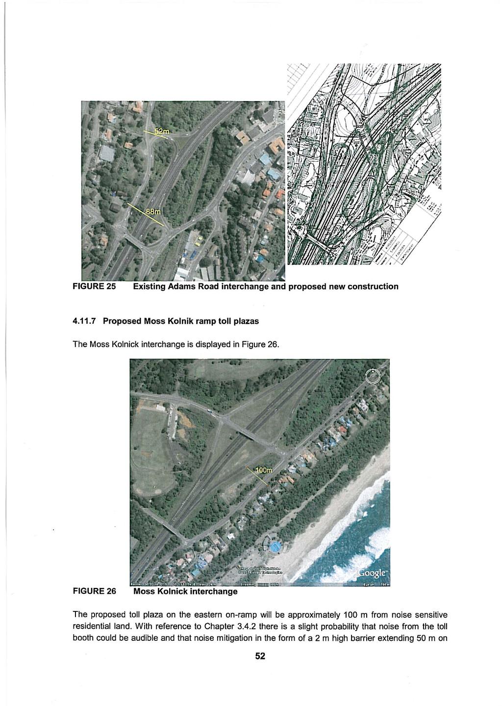
23 Proposed Umkomaas ramp toll plazas Ramp toll plazas are proposed on the northern ramps of the Umkomaas interchange shown in Figure 24. Noise sensitive residential land is situated beyond 100m of the western on-ramp. With reference to Chapter no noise impact is anticipated and no noise mitigation procedures would be required. The boundary of what appears to be a new residential complex is situated less than 40 m from eastern off-ramp. In terms of the NCR the developer of that land is obliged to implement noise mitigation procedures that will ensure that the L Req,d on that land due to road traffic noise does not exceed 65 dba. The elevation of the nearest boundary of the complex is several metres higher than the off-ramp. Provided that the height of the boundary wall, apparent in Figure 24, is adequate to mitigate noise from the Highway, it is anticipated that it will also be adequate to mitigate noise from the ramp toll plaza. FIGURE 24 Umkomaas interchange Proposed Adams Road ramp toll plazas The existing Adams Road interchange and the proposed reconstruction is displayed in Figure 25. The positions of the toll booths have not been indicated. Commercial land lies to the east of the interchange for which no noise impact is anticipated. Noise sensitive residential land is situated in close proximity of both of the existing ramps. It is proposed to build a new bridge across the freeway just north of the existing off- and on-ramps with the new ramps connecting at the western side of the bridge. The increased elevation of the off-ramp and the commencement of the on-ramp will result in these being more exposed to the residences. The potential for a noise impact on this land is therefore high. The potential noise impact of toll plazas on the new ramps and relevant noise mitigation procedures will need to be incorporated in the detail design stage. 51
24
Perth and Kinross Council Development Control Committee 27 August 2008 Recommendation by Development Quality Manager
 Perth and Kinross Council Development Control Committee 27 August 2008 Recommendation by Development Quality Manager 5(7) 08/414 Erection of kennels and cattery at Baltree Farm, Hatchbank, Kinross, KY13
Northeast Stoney Trail In Calgary, Alberta
 aci Acoustical Consultants Inc. 5031 210 Street Edmonton, Alberta, Canada T6M 0A8 Phone: (780) 414-6373, Fax: (780) 414-6376 www.aciacoustical.com Environmental Noise Computer Modelling For Northeast Stoney
Non-technical summary
 Introduction NTS1 NTS2 NTS3 Troika Developments Ltd (Troika) has submitted a planning application to Bournemouth Borough Council (BBC) for an extension of time to implement planning permission 7/2004/16450/G,
General Summer and Winter Views
 ENVIRONMENTAL INFORMATION REPORT VOLUME 4 APPENDIX 11. 2 General Summer and Winter Views Table of Contents Section APPENDIX 11.2 Page 1 General Views... 1-1 Tansy Lane, Portishead... 1-2 Galingale Way,
Dallas Executive Airport
 648 DECLARED DISTANCE OPTION 1a DISPLACE 31 THRESHOLD BY 97 Considers RSA Limiting Factor No runway extensions 13 31 TORA 6,451 6,451 TODA 6,451 6,451 ASDA 5,958 6,451 LDA 5,958 6,354 Runway 17-35 (3,8
SCOPE Chapter 2D shall Apply to Any Road or
 SCOPE Chapter 2D shall Apply to Any Road or Street other then Low-Volume Roads, Expressways, and Freeways Low Volume Roads: Shall be a Facility Lying Outside Built-Up Areas & Having a Traffic Volume Less
Perth Airport. Runway 21 Night-Time Departure Trial Proposal. Environmental Analysis Summary. August Airservices Australia 1 of 17
 Perth Airport Runway 21 Night-Time Departure Trial Proposal Environmental Analysis Summary August 2015 Airservices Australia 1 of 17 Change Summary Version Date Change Description Amended by 1 6 August
STAFF REPORT. Airport Land Use Consistency Determination Betteravia Plaza. MEETING DATE: January 21, 2016 AGENDA ITEM: 8D
 STAFF REPORT SUBJECT: Airport Land Use Consistency Determination Betteravia Plaza MEETING DATE: AGENDA ITEM: 8D STAFF CONTACT: Andrew Orfila RECOMMENDATION: Adopt findings for the Betteravia Plaza project
A. CONCLUSIONS OF THE FGEIS
 Chapter 11: Traffic and Parking A. CONCLUSIONS OF THE FGEIS The FGEIS found that the Approved Plan will generate a substantial volume of vehicular and pedestrian activity, including an estimated 1,300
London Biggin Hill Airport Runway 03 Approach A9912 N02 DC. Noise Assessment Extended D Charles 1.0 INTRODUCTION
 Project: File Ref: London Biggin Hill Airport Runway 03 Approach Date: 6 January 2016 Subject: From: Noise Assessment Extended D Charles To: Name Company Will Curtis Peter Mirams Barry Hawkins London Biggin
APPENDIX I: ACCESS REQUIREMENTS WITHIN THE EASTERN CAPE SECTION OF THE ROUTE
 APPENDIX I: ACCESS REQUIREMENTS WITHIN THE EASTERN CAPE SECTION OF THE ROUTE Table 1: East London to Komga Interchange 1. Characterised by commercial and subsistence farming 2. Informal trading along the
27 January Stayover by Ausco 44 Formation Street Wacol QLD Dear Myke,
 Our Ref: L01316/PAK/15-184 27 January 2016 Stayover by Ausco 44 Formation Street Wacol QLD 4076 Attention: Mr Myke Cavanagh Dear Myke, Re: Stayover on Zeller Chinchilla Workers Accommodation Facility Development
APPENDIX 3: Acoustic Assessment (Hegley Acoustic Consultants)
") APPENDIX 3: Acoustic Assessment (Hegley Acoustic Consultants) Proposed Waikato District Plan Section 32 - Te Kowhai Airpark Zone Report 1/355 Manukau Road Epsom, Auckland 1023 PO Box 26283 Epsom, Auckland
APPENDIX 3: Acoustic Assessment (Hegley Acoustic Consultants) Proposed Waikato District Plan Section 32 - Te Kowhai Airpark Zone Report 1/355 Manukau Road Epsom, Auckland 1023 PO Box 26283 Epsom, Auckland
STAFF REPORT. Airport Land Use Plan Consistency Review: Old Town Village Mixed Use Project City of Goleta. MEETING DATE: June 18, 2015 AGENDA ITEM: 5M
 STAFF REPORT SUBJECT: Airport Land Use Plan Consistency Review: Old Town Village Mixed Use Project City of Goleta MEETING DATE: AGENDA ITEM: 5M STAFF CONTACT: Peter Imhof, Andrew Orfila RECOMMENDATION:
Measuring, Managing and Mitigating Aircraft Related Noise
 Measuring, Managing and Mitigating Aircraft Related Noise Airport noise is, understandably, a significant issue for some of our neighbouring communities. Achieving the most appropriate balance between
REVIEW OF GOLD COAST AIRPORT Noise Abatement Procedures
 REVIEW OF GOLD COAST AIRPORT Noise Abatement Procedures Introduction The purpose of this document is to present an overview of the findings of the review of the Noise Abatement Procedures (NAPs) in place
SUBMISSION BY THE BOARD OF AIRLINE REPRESENTATIVES OF NEW ZEALAND ON THE DRAFT QUEENSTOWN LAKES DISTRICT COUNCIL DRAFT PLAN
 SUBMISSION BY THE BOARD OF AIRLINE REPRESENTATIVES OF NEW ZEALAND ON THE DRAFT QUEENSTOWN LAKES DISTRICT COUNCIL DRAFT PLAN Background to BARNZ BARNZ is an incorporated society comprising 19 member airlines
APPENDIX 6 TOURISM. Specialist. Peer Reviewer. Martin Janse van Vuuren Grant Thornton Strategic Solutions. Heidi Keyser ED/GE Tourism Solutions
 APPENDIX 6 TOURISM Specialist Martin Janse van Vuuren Grant Thornton Strategic Solutions Peer Reviewer Heidi Keyser ED/GE Tourism Solutions Proposed N2 Wild Coast Toll Highway SPECIALIST STUDY ON THE POTENTIAL
Issues relating to potential tourism impacts GENERAL RESPONSE:
 Table 8: Issues relating to potential tourism impacts GENERAL RESPONSE: A detailed Tourism Assessment was undertaken as part of the EIA study (refer to Volume 2, Book 2 of the draft EIA Report). This study
APPENDIX J MODIFICATIONS PERFORMED TO THE TOR
 APPENDIX J MODIFICATIONS PERFORMED TO THE TOR This appendix summarizes the modifications that were performed in years 2012 and 2017 to rectify calculation errors that were observed in the data presented
4. Bronze Age Ballybrowney, County Cork Eamonn Cotter
 4. Bronze Age Ballybrowney, County Cork Eamonn Cotter Illus. 1 Location map of the excavated features at Ballybrowney Lower (Archaeological Consultancy Services Ltd, based on the Ordnance Survey Ireland
Noise Action Plan Summary
 2013-2018 Noise Action Plan Summary Introduction The EU Noise Directive 2002/49/EU and Environmental Noise (Scotland) Regulations 2006 requires airports with over 50,000 movements a year to produce a noise
The following criteria shall be applied within the boundaries of the AO District:
 Sec. 419 (a) Purpose AIRPORT OVERLAY DISTRICT (AO) The purpose of the Airport Overlay District is to regulate and restrict the height of structures, objects, or natural growth, regulate the locations of
The project comprises the design of the following works:
 An integrated approach to the design of the port and marina infrastructure of the island of Mykonos D. Avgoustinos, N. Panagopoulos, I. Sioris TRITON Consulting Engineers Ltd, 10 Makedonon Str., 11521
E40. Temporary activities
 E40. Temporary activities E40.1. Background Temporary activities contribute to Auckland's vibrancy and to the social, cultural and economic well-being of communities. Temporary activities also enable filming
U-Park Wyatt Street Temporary Event Space
 Adelaide City Council 26-May-2015 Doc No. 60427502-A15E01RP U-Park Wyatt Street Temporary Event Space Music Noise Assessment U-Park Wyatt Street Temporary Event Space Music Noise Assessment Client: Adelaide
5 MAP SPECIFICATION FOR SKI-ORIENTEERING
 5 MAP SPECIFICATION FOR SKI-ORIENTEERING 5.1 General Maps for ski orienteering are based on the specifications for foot-orienteering maps. However in order to meet the specific requirements put on the
November 11, 2009 BY . Planning and Growth Management Department 110 Laurier Avenue West, 4 th Floor Ottawa, Ontario K1P 1J1. Dear Mr.
 November 11, 2009 Planning and Growth Management Department 110 Laurier Avenue West, 4 th Floor Ottawa, Ontario K1P 1J1 BY E-MAIL Attention: Mr. Don Herweyer Dear Mr. Herweyer: Reference: Abbott-Fernbank
VISUAL Impact Assessment
 5.0 Existing Landscape Character TO GOULBURN FEDERAL HIGHWAY 5.1 Landscape Character Units Generally one of the first steps in carrying out a landscape and visual assessment is to identify and map the
REVIEW OF PERTH AIRPORT Noise Abatement Procedures
 REVIEW OF PERTH AIRPORT Noise Abatement Procedures Contents SUMMARY... 3 Summary of Review Findings... 3 BACKGROUND... 4 Noise Abatement Procedures... 4 Perth Airport Noise Abatement Procedures... 4 Noise
12, 14 and 16 York Street - Amendments to Section 16 Agreement and Road Closure Authorization
 REPORT FOR ACTION 12, 14 and 16 York Street - Amendments to Section 16 Agreement and Road Closure Authorization Date: April 27, 2018 To: Toronto and East York Community Council From: Senior Strategic Director,
ISOM & ISSOM forbidden symbol comparison
 & forbidden symbol comparison Forbidden symbols and their relatives Symbol 2000 (Long, Middle) 2007 (Sprint) 201 Impassable cliff An impassable cliff, quarry or earth bank (see 106) is shown with a 0.35
Gatwick Airport Limited. Response to Airports Commission Consultation. Appendix. Ian H Flindell & Associates - Ground Noise Report
 Gatwick Airport Limited Response to Airports Commission Consultation Appendix 10 Ian H Flindell & Associates - Ground Noise Report GATWICK AIRPORT Technical Report in response to Airports Commission Consultation
LAX Specific Plan Amendment Study (SPAS) Final EIR and Related Actions. Board of Airport Commissioners February 5, 2013
 Final EIR and Related Actions. Board of Airport Commissioners February 5, 2013") LAX Specific Plan Amendment Study (SPAS) Final EIR and Related Actions Board of Airport Commissioners February 5, 2013 1 Background The LAX Master Plan Program serves as the airport s long range development
LAX Specific Plan Amendment Study (SPAS) Final EIR and Related Actions Board of Airport Commissioners February 5, 2013 1 Background The LAX Master Plan Program serves as the airport s long range development
CHAPTER 6 NOISE EXPOSURE
 CHAPTER 6 NOISE EXPOSURE FAA requires that the NEM submitted for review represent the aircraft noise exposure for the year of submittal (in this case 2008) and for a future year (2013 for OSUA). However,
CHAPTER 1 BACKGROUND AND PROPOSED ACTION
 CHAPTER 1 BACKGROUND AND PROPOSED ACTION 1.0 INTRODUCTION An Environmental Assessment (EA) evaluates the effects of a proposed Federal action on the surrounding environment and is prepared in compliance
Chapter 4 Route Window NE3 Manor Park station. Transport for London
 Chapter 4 Route Window NE3 Manor Park station MANOR PARK STATION 4 Route Window NE3 Manor Park station 4.7 Highway access to Manor Park station is very good. A117 Station Road connects with A116 to the
CHAPTER 3 ALTERNATIVES CONSIDERED
 CHAPTER 3 ALTERNATIVES CONSIDERED 3.0 ALTERNATIVES The 2010 Stevensville Airport Master Plan contained five (5) airside development options designed to meet projected demands. Each of the options from
a. The historic avalanche areas, or areas in which there exists clear evidence of previous avalanches, are mapped.
 1 OBJECTIVES AND LIMITATIONS OF STUDY ;J'-o~ 1 j 1.1 BACKGROUND AND STUDY OBJECTIVES The communities of Aspendell, Habegger's, and Sage Flat are located in the eastern Sierra Nevada west of the towns of
MiSP Topographic Maps Worksheet #1a SLOPE AND TOPOGRAPHIC CONTOURS
 MiSP Topographic Maps Worksheet #1a Name Date Introduction: SLOPE AND TOPOGRAPHIC CONTOURS Topographic contours are shown by lines of different widths. Each contour is a line of equal elevation; therefore,
Lansdowne Wetton BRT Public Transport Corridor Trunk Route: Planning Analysis
 Lansdowne Wetton BRT Public Transport Corridor Trunk Route: Planning Analysis 1. Introduction The purpose of this report is to detail the planning evaluation for the trunk route alignment alternatives
Chapter 2 Route window W25 Maidenhead station. Transport for London
 Chapter 2 Route window W25 Maidenhead station MAIDENHEAD STATION 2 Route window W25 Maidenhead station 2.6 The drawings provided at the end of this chapter present the main features of the route window,
Definition of overflight
 Policy Programmes Team Definition of overflight CAP 1498 Published by the Civil Aviation Authority, 2017 Civil Aviation Authority, Aviation House, Gatwick Airport South, West Sussex, RH6 0YR. You can copy
IV. ENVIRONMENTAL IMPACT ANALYSIS N. AESTHETICS
 IV. ENVIRONMENTAL IMPACT ANALYSIS N. AESTHETICS ENVIRONMENTAL SETTING Introduction This examination of aesthetics is based upon an evaluation of two categories of values: visual character and the attributes
4. Safety Concerns Potential Short and Medium-Term Improvements
 NH Route 104 Access Management Study Page 19 4. Safety Concerns Potential Short and Medium-Term Improvements Potential safety improvement strategies are listed by priority based on field observations by
5.17 STRANDFONTEIN (permanent population: + 110) (IDP )
 (IDP )") page 305 5.17 STRANDFONTEIN (permanent population: + 110) (IDP 2012-2017) 5.17.1 SPATIAL ANALYSIS, see Figures 5.17.1 Sub-regional location On the West Coast, approximately 8kms north of Doringbaai and
page 305 5.17 STRANDFONTEIN (permanent population: + 110) (IDP 2012-2017) 5.17.1 SPATIAL ANALYSIS, see Figures 5.17.1 Sub-regional location On the West Coast, approximately 8kms north of Doringbaai and
DEPARTMENT: CIVIL ENGINEERING SEMESTER: III SUBJECT CODE / Name: CE2303/ Railway, Airport and Harbors Engineering 2 MARK QUESTIONS AND ANSWERS
 DEPARTMENT: CIVIL ENGINEERING SEMESTER: III SUBJECT CODE / Name: CE2303/ Railway, Airport and Harbors Engineering 2 MARK QUESTIONS AND ANSWERS 1.Define wind Coverage (AUC NOV/DEC 2010),(AUC NOV/DEC 2011)
To: From: Plans showing the alignments of the routes discussed in this section are presented in Appendix A.
 Project: Cambourne to Cambridge Better Bus Journeys To: CCC Subject: Considerations for Corridor Option Plans From: Atkins Date: 1 Sep 2016 cc: 1. Introduction This note summarises considerations undertaken
Section 3-04 Cross Sectional Elements TABLE OF CONTENTS. INTRODUCTION...3 General...3 Exhibit 1-Cross-Sectional Elements...3
 Section 3-04 Cross Sectional Elements TABLE OF CONTENTS INTRODUCTION...3 General...3 Exhibit 1-Cross-Sectional Elements...3 CROSS-SECTIONAL ELEMENTS...3 Traveled Way...3 Shoulder...3 Surfacing Taper...3
A-100- Rev7-28 June Head Office: Perth, Western Australia. Machine Condition Monitoring Structural Dynamics
 PROPOSED OUTER HARBOUR DEVELOPMENT PILE DRIVING NOISE ASSESSMENT REPORT BHP BILLITON IRON ORE 075063--6A-100- Rev7-28 June 2010 www.svt.com.au Head Office: Perth, Western Australia Kuala Lumpur, Malaysia
Perth Noise Abatement Procedures - Change to Preferred Runways
 Environmental Analysis Summary Preferred Runways Perth Perth Airport Perth Noise Abatement Procedures - Change to Preferred Runways Environmental Analysis Summary April 2016 1 of 10 Environment Analysis
I508. Devonport Peninsula Precinct
 I508. Devonport Peninsula Precinct I508.1. Precinct description The purpose of the Devonport Peninsula precinct is to provide for the comprehensive residential development of the former Navy housing land
Safety and Airspace Regulation Group
 Page 1 of 11 Airspace Change Proposal - Environmental Assessment Version: 1.0/ 2016 Title of Airspace Change Proposal Change Sponsor Isle of Man/Antrim Systemisation (Revised ATS route structure over the
Memorandum. Roger Millar, Secretary of Transportation. Date: April 5, Interstate 90 Operations and Mercer Island Mobility
 Memorandum To: From: The Honorable Dow Constantine, King County Executive; The Honorable Ed Murray, City of Seattle Mayor; The Honorable Bruce Bassett, City of Mercer Island Mayor; The Honorable John Stokes,
INNOVATIVE TECHNIQUES USED IN TRAFFIC IMPACT ASSESSMENTS OF DEVELOPMENTS IN CONGESTED NETWORKS
 INNOVATIVE TECHNIQUES USED IN TRAFFIC IMPACT ASSESSMENTS OF DEVELOPMENTS IN CONGESTED NETWORKS Andre Frieslaar Pr.Eng and John Jones Pr.Eng Abstract Hawkins Hawkins and Osborn (South) Pty Ltd 14 Bree Street,
Survey of Littleton Down
 Survey of Littleton Down 05 November 2014 The Team: John and Jenny Barnard 1) Introduction Littleton Down (Hill Number 2911, Section 42, OS 1:50000 Map 197, OS 1:25000 Map 121, Grid Ref. SU941150) is listed
Draft Concept Alternatives Analysis for the Inaugural Airport Program September 2005
 Section 10 Preferred Inaugural Airport Concept 10.0 Introduction The Preferred Inaugural Airport Concept for SSA was developed by adding the preferred support/ancillary facilities selected in Section 9
MiSP Topographic Maps Worksheet #1a L2
 MiSP Topographic Maps Worksheet #1a L2 Name Date SLOPE AND TOPOGRAPHIC CONTOURS Introduction: Topographic contours are shown by lines of different widths. Each contour is a line of equal elevation; therefore,
The Transportation Corridor Overlay District
 The Transportation Corridor Overlay District The Transportation Corridor Overlay District is a policy framework under which certain potentially beneficial development proposals may be considered, given
CHRISTCHURCH INTERNATIONAL AIRPORT NOISE MANAGEMENT PLAN. 28 March 2014 V10
 CHRISTCHURCH INTERNATIONAL AIRPORT NOISE MANAGEMENT PLAN 28 March 2014 V10 419879.1ws34.tmp Page 1 TABLE OF CONTENTS 1.0 Introduction... 3 2.0 Aircraft Noise - Operations... 5 2.1 City Plan Requirements...
Lake Erie Commerce Center Traffic Analysis
 LOCATION: East of NYS Route 5 at Bayview Road Town of Hamburg Erie County, New York PREPARED BY: Wendel Companies 140 John James Audubon Parkway Suite 200 Amherst, New York 14228 January 2012 i ii Table
Consideration will be given to other methods of compliance which may be presented to the Authority.
 Advisory Circular AC 139-10 Revision 1 Control of Obstacles 27 April 2007 General Civil Aviation Authority advisory circulars (AC) contain information about standards, practices and procedures that the
II. Purpose and Need. 2.1 Background
 II. 2.1 Background The Metropolitan Washington Airports Authority is preparing an Environmental Assessment of potential environmental impacts associated with proposed enhancements to the Runway 4-22 and
Section 106 Update Memo #1 Attachment D. Traffic Diversion & APE Expansion Methodology & Maps
 Section 106 Update Memo #1 Attachment D Traffic Diversion & APE Expansion Methodology & Maps I-65/I-70 North Split Interchange Reconstruction Project (Des. Nos. 1592385 & 1600808) Traffic Diversion and
Transport Impact Assessment
 Transport Impact Assessment Springbok Hotel Erf 5206, Springbok Northern Cape March 2018 5th Floor Imperial Terraces Carl Cronje Drive Tyger Waterfront Bellville, 7530 (021) 914 6211 (T) e mail: mail@itsglobal.co.za
Treasure Island Supplemental Information Report Addendum
 1 1 1 1 0 1 0 1 0 1 Treasure Island Supplemental Information Report Addendum Introduction Purpose The purpose of this Supplemental Information Report (SIR) Addendum is to determine if the current land
Alternative Highest & Best Use Analysis Boutique Hotel
 Alternative Highest & Best Use Analysis In response to numerous comments received from the public, as well as issues raised by the CCC in the Appeal Staff Report Substantial Issue Determination, the following
FRENCH VALLEY AIRPORT (F70) Sky Canyon Dr. Murrieta, CA. Phone: Riverside FAA FSDO Complaint Line: (951)
 Sky Canyon Dr. Murrieta, CA. Phone: Riverside FAA FSDO Complaint Line: (951)") FRENCH VALLEY AIRPORT (F70) 37600 Sky Canyon Dr. Murrieta, CA Phone: 951-600-7297 Riverside FAA FSDO Complaint Line: (951) 276-6701 Visit the F70 website for additional information regarding the airport
FRENCH VALLEY AIRPORT (F70) 37600 Sky Canyon Dr. Murrieta, CA Phone: 951-600-7297 Riverside FAA FSDO Complaint Line: (951) 276-6701 Visit the F70 website for additional information regarding the airport
ACI EUROPE POSITION. on the revision of. EU DIRECTIVE 2002/30 (noise-related operating restrictions at community airports)
") ACI EUROPE POSITION on the revision of EU DIRECTIVE 2002/30 (noise-related operating restrictions at community airports) 6 SEPTEMBER 2011 EU Directive 2002/30 Introduction 1. European airports have a long
ACI EUROPE POSITION on the revision of EU DIRECTIVE 2002/30 (noise-related operating restrictions at community airports) 6 SEPTEMBER 2011 EU Directive 2002/30 Introduction 1. European airports have a long
Traffic Calming Measures
 REPUBLIC OF GHANA MINISTRY OF TRANSPORTATION Ghana Highway Authority Road Safety and Environment Division Traffic Calming Measures Design Guideline Version 1 / July 2007 Traffic Calming Measures Page 2
Master Plan & Noise Compatibility Study Update
 Working Document-Subject to Change, March 2010 Master Plan & Noise Compatibility Study Update (14 CFR Part 150) TECHNICAL ADVISORY COMMITTEE March 24, 2010 Working Document-Subject to Change, March 2010
ACI EUROPE POSITION. on the revision of. EU DIRECTIVE 2002/30 (noise-related operating restrictions at community airports)
") ACI EUROPE POSITION on the revision of EU DIRECTIVE 2002/30 (noise-related operating restrictions at community airports) 10 JULY 2011 EU Directive 2002/30 European airports have a long history of noise
ACI EUROPE POSITION on the revision of EU DIRECTIVE 2002/30 (noise-related operating restrictions at community airports) 10 JULY 2011 EU Directive 2002/30 European airports have a long history of noise
CHAPTER ONE LITERATURE REVIEW
 CHAPTER ONE LITERATURE REVIEW LITERATURE REVIEW This chapter summarizes the most recently published community impact studies and articles that relate to multiuse trails. The review focuses on publications
STAFF REPORT. Airport Land Use Plan Consistency Review: Santa Barbara Airport Master Plan. MEETING DATE: November 19, 2015 AGENDA ITEM: 7D
 STAFF REPORT SUBJECT: Airport Land Use Plan Consistency Review: Santa Barbara Airport Master Plan MEETING DATE: AGENDA ITEM: 7D STAFF CONTACT: Peter Imhof, Andrew Orfila RECOMMENDATION: Adopt findings
At a meeting of the Development Management Committee held on 22 February 2018
 1 HAVANT BOROUGH COUNCIL At a meeting of the held on Present Councillor Keast (Chairman) Councillors Buckley, Hughes, Keast, Perry, Satchwell, Lloyd and Guest (Standing Deputy) 105 Apologies for Absence
Canberra Airport Aircraft Noise Information Report
 Canberra Airport Aircraft Noise Information Report Quarter 1 2016 (January to March) 1 Version Control Version Number Detail Prepared by Date 1 - Environment June 2016 Airservices Australia. All rights
Canberra Airport Aircraft Noise Information Report
 Canberra Airport Aircraft Noise Information Report Quarter 4 2015 (October to December) 1 Version Control Version Number Detail Prepared by Date 1 - Environment March 2016 Airservices Australia. All rights
Environmental Assessment. Runway 14 Runway 14 southern departures trial Gold Coast Airport
 Environmental Assessment Runway 14 Runway 14 southern departures trial Gold Coast Airport Change Summary Version Date Change Description Amended by 1 21/11/14 New document Community Relations 2 17/12/15
Spencer Environmental Appendix A: Alternative Analysis for Construction Access Route
 Spencer Environmental Appendix A: Alternative Analysis for Construction Access Route February 2015 Valley ine-stage 1 RT EISA Update FINA REPORT Page A1 Memorandum AECOM ConnectEd Transit Partnership 10235
Draft Concept Alternatives Analysis for the Inaugural Airport Program September 2005
 Draft Concept Alternatives Analysis for the Inaugural Airport Program September 2005 Section 3 - Refinement of the Ultimate Airfield Concept Using the Base Concept identified in Section 2, IDOT re-examined
Appendix 7 - Air noise, aircraft ground noise (taxiing and APU operation), and road traffic noise sound levels
, and road traffic noise sound levels") Appendix 7 - Air noise, aircraft ground noise (taxiing and APU operation), and road traffic noise sound levels Contents 1 Introduction 3 2 Assessment 3 Tables Table 1: 2015 and 2030 base case air noise,
Appendix 7 - Air noise, aircraft ground noise (taxiing and APU operation), and road traffic noise sound levels Contents 1 Introduction 3 2 Assessment 3 Tables Table 1: 2015 and 2030 base case air noise,
VI. ALTERNATIVES TO THE MASTER PLAN C. RENOVATED EAST BUILDING ALTERNATIVE
 VI. ALTERNATIVES TO THE MASTER PLAN C. RENOVATED EAST BUILDING ALTERNATIVE INTRODUCTION The Renovated East Building Alternative would include the continued use of the renovated West Building and the renovation
2006 WEEKDAY TRAFFIC PROFILE. June 15, 2007
 June 15, 2007 Mr. Gary Stobb, P.E. Director of Planning/Operations Harris County Toll Road Authority 330 Meadowfern, Suite 200 Houston, TX 77067 Re: Westpark Tollway Value Pricing Analysis Dear Mr. Stobb:
Construction Staging Adelaide Street West
 REPORT FOR ACTION Construction Staging Adelaide Street West Date: October 6, 2016 To: Toronto and East York Community Council From: Acting Director, Transportation Services, Toronto and East York District
Control of Cranes and Other Temporary Obstacles
 United Kingdom Overseas Territories Aviation Circular OTAC 139-27 140-11 171-8 172-11 178-10 Control of Cranes and Other Temporary Obstacles Issue 1 1 June 2018 Effective on issue GENERAL Overseas Territories
Chapter 14 Route Window C12 Mile End Park and Eleanor Street shafts. Transport for London
 Chapter 14 Route Window C12 Mile End Park and Eleanor Street shafts MILE END PARK AND ELEANOR STREET SHAFTS 14 Route Window C12 Mile End Park and Eleanor Street shafts Introduction 14.1 Crossrail s twin
LYNDHURST NEW URBAN DEVELOPMENT AREA STRUCTURE PLAN. Lyndhurst New Urban Development Area Structure Plan OUTCOMES AND PERFORMANCE STANDARDS
 APPENDIX 15.1-3 LYNDHURST NEW URBAN DEVELOPMENT AREA STRUCTURE PLAN Purpose of the Structure Plan Lyndhurst New Urban Development Area Structure Plan OUTCOMES AND PERFORMANCE STANDARDS LSP-P1 The District
3. COLTA / HUGA CONNECTIONS - PRELIMINARY
 9 3. COLTA / HUGA CONNECTIONS - PRELIMINARY 3.1 COLTA The Chain of Lakes Trail Association (COLTA) trail, formerly identified as the Chester Spur Line, was completed and opened for use in June 2011. The
PART D: Potential environmental impact of proposals affecting Southport, Formby, Ormskirk, Skelmersdale and surrounding areas
 IRISH SEA AIRSPACE CHANGE PROPOSAL PART D: Potential environmental impact of proposals affecting Southport, Formby, Ormskirk, Skelmersdale and surrounding areas Page D1 of D12 Introduction 1. This part
NOISE ABATEMENT PROCEDURES
 1. Introduction NOISE ABATEMENT PROCEDURES Many airports today impose restrictions on aircraft movements. These include: Curfew time Maximum permitted noise levels Noise surcharges Engine run up restrictions
Quiet Climb. 26 AERO First-Quarter 2003 January
 Quiet Climb Boeing has developed the Quiet Climb System, an automated avionics feature for quiet procedures that involve thrust cutback after takeoff. By reducing and restoring thrust automatically, the
1 PROJECT STATUS UPDATE 2 ND CONCESSION FROM BRISTOL ROAD TO DOANE ROAD TOWNS OF EAST GWILLIMBURY AND NEWMARKET
 Report No. 3 of the Regional Council Meeting of March 28, 2013 1 PROJECT STATUS UPDATE 2 ND CONCESSION FROM BRISTOL ROAD TO DOANE ROAD TOWNS OF EAST GWILLIMBURY AND NEWMARKET The recommends: 1. Receipt
Trail Phasing Plan. Note: Trails in the Clear Creek Canyon area (Segments will be finalized in the future to minimize wildlife impacts
 Note: Trails in the Clear Creek Canyon area (Segments 2 5 and a future JCOS connection) will be finalized in the future to minimize wildlife impacts Trail Phasing Plan P Parking 3 Easy Trail Intermediate
Christchurch PBN Flight Paths Trial. Interim Report
 Christchurch PBN Flight Paths Trial Interim Report Christchurch PBN Flight Paths Trial Interim Report PBN trial partners have prepared the following summary outlining progress of the PBN flight paths trial.
Dublin Airport - Noise Management Plan
 Dublin Airport - Noise Management Plan May 2018 Issue: Final Prepared By: daa Reviewed By: Noise Strategy Working Group 15/5/2017 Authorised By: Group Head Asset Care 22/05/2018 Contents Abbreviations...
Tbilisi Railway Bypass Project
 Your opinion and comments in the process of project assessment have significant importance Tbilisi Railway Bypass Project The Brochure will introduce you with Tbilisi Railway Bypass project and give a
The Atlas of Hillforts of Britain and Ireland. Hillfort survey notes for guidance
 The Atlas of Hillforts of Britain and Ireland Hillfort survey notes for guidance The collection of surveys for the Atlas is now finished but you can use this form and the accompanying Notes for Guidance
Capital & Counties. October 2007
 Capital & Counties October 2007 Contents!" # $ % % $ & ' "&( # Appendix 1 Appendix 2 1 Introduction 1.1.1 Wincheap regeneration scheme proposes a 600 space Park and Ride facility to replace the existing
Provincial Railway Technical Standards
 GENERAL: INDEX: The standards and requirements listed in this document are intended for use on provincially regulated railway public grade crossings. These standards are considered the minimum requirements
Cairns Airport Aircraft Noise Information Report. Quarter (July to September)
") Cairns Airport Aircraft Noise Information Report Quarter 3 2012 (July to September) 1 Version Control Version Number Detail Prepared by Date 1 - Environment 19 December 2012 Airservices Australia. All
Cairns Airport Aircraft Noise Information Report Quarter 3 2012 (July to September) 1 Version Control Version Number Detail Prepared by Date 1 - Environment 19 December 2012 Airservices Australia. All