November 8, Members: Ms. Eileen Mackin-Getzoff Chair Dr. Yarrow Nelson Vice Chair Mr. Robert Carr Mr. Ryan Andrews Mr.
|
|
|
- Marshall Rodger McDowell
- 6 years ago
- Views:
Transcription

1 - Jim Suty, President Garcal Drive San Jose, CA November 8, 2017 San Luis Obispo County Air Pollution Control District Hearing Board Members and Alternates c/o Alyssa Roslan, Clerk of the Hearing Board 3433 Roberto Court San Luis Obispo, Ca Members: Ms. Eileen Mackin-Getzoff Chair Dr. Yarrow Nelson Vice Chair Mr. Robert Carr Mr. Ryan Andrews Mr. William Johnson Alternates: Mr. Paul Ready Dr. Thomas Richards Mr. James Anderson Mr. Rick Rittenberg Re: The November 13 abatement hearing. Honorable Members of the Hearing Board, These comments are filed on behalf of Friends of Oceano Dunes, Inc. ("Friends"), which is a California not-for-profit corporation, representing approximately 28,000 members and users of the Oceano Dunes State Vehicle Recreation Area ("SVRA") located near Pismo Beach, California. We would like to address the following points: a) Friends would like to offer an adaptive management process to meet the needs of all involved Balanced Recreation b) Historical acreage lost and APCD proposals ask to take more away c) Natural dunes need to be appropriately defined 28,000 supporters. We represent environmentalists, equestrians, campers, fishermen, families and off-road enthusiasts who enjoy the benefits of Public Access through Responsible Recreation at the Oceano Dunes State Vehicular Recreation Area (ODSVRA). We want to maintain Access For All! Page 1 of 22
2 a) Friends would like to offer an adaptive management process to meet the needs of all involved Balanced Recreation Friends believes that the entire acreage needs to be revisited to establish a new SVRA that balances the needs of all involved. This is exactly what the Public Resources Code desired: (a) The Legislature finds that off-highway motor vehicles are enjoying an ever-increasing popularity in California and that the indiscriminate and uncontrolled use of those vehicles may have a deleterious impact on the environment, wildlife habitats, native wildlife, and native flora. (b) The Legislature hereby declares that effectively managed areas and adequate facilities for the use of off-highway vehicles and conservation and enforcement are essential for ecologically balanced recreation. (c) Accordingly, it is the intent of the Legislature that: (1) Existing off-highway motor vehicle recreational areas, facilities, and opportunities be expanded and be managed in a manner consistent with this chapter, in particular to maintain sustained long-term use. (2) New off-highway motor vehicle recreational areas, facilities, and opportunities be provided and managed pursuant to this chapter in a manner that will sustain long-term use. What Friends recommends is: The park acreage meet the intent of the Public Resources Code and the acreage be divided in half to support balanced recreation acres divided by 2 = 1795 acres for OHV and camping and 1795 acres for species protection, dust mitigation and other adaptive management needs. Establish a no net loss philosophy to ensure continued use and protective measures. If acreage is needed for dust mitigation or species protection, then a 1:1 replacement occurs where acreage is opened to offset the need to close other acreage. Provide State Parks the ability to apply adaptive management practices which meet the needs of all involved by managing the balanced acreage use with a no-net-loss philosophy. State Parks is the land manager who needs the flexibility to manage the park in the most effective manner. Page 2 of 22

3 b) Historical acreage lost and APCD proposals ask to take more away The ODSVRA has been used for camping and off-road recreation for over 100 years. There is a long history of enjoying the entire Guadalupe Dune Complex, which includes the Oceano Dunes SVRA. In 1982 a significant portion of the dunes were closed. Page 3 of 22

4 Page 4 of 22

5 Over time, there have been many actions taken which have continued to reduce the area for camping and recreation acreage for beach camping reduced 2001 acreage for beach camping reduced Page 5 of 22

6 2002 acreage for beach camping further reduced & acreage for 1000 foot seasonal buffer taken 2003 acreage for beach camping further reduced and exclosure moved to Pole 6. Page 6 of 22

7 2017 APCD & CCC Staff recommends permanently closing and vegetating acreage with further reduces the park Further reductions in the parks acreage adds congestion and increases the risk of injury of the visitors. Significant economic impact may occur if beach access is reduced to protect the safety of the visitors. Page 7 of 22

8 c) Natural dunes need to be appropriately defined Many see vegetated dunes and think it is natural, but as we will show you they are not. In order to understand and appreciate the current landscape, one must also review the landscape from years gone by. For this reason, we have put together the following document to aid in discussion. The Oceano Dunes and surrounding area has been a great place for tourists and recreation for approximately one hundred years. Due to this popularity, there have been many photographs taken and stories written to remind us of this history. For example, let s first look at the area now known as Pier Avenue. Many years ago this was just a solitary road leading out to a hotel, which looked out over the beautiful coast. The following is a photo of a photo, which hangs on the wall inside the Guiton Realty office in Oceano. The Guiton family has lived in Oceano for many generations and they have provided a plethora of old photographs and information. The hotel sits where Pier Avenue currently meets the beach. Please note the barren sand north of the hotel. Page 8 of 22

9 The following aerial photo was taken in If one looks closely at the photo to the left, one will clearly see the Oceano Airport and Pier Avenue. Looking north, one will see that the area is virtually void of foredunes and vegetation. Please remember, when this photo was taken in 1956, most vehicles were forced to stay on the hard wetpacked sand because of their skinny, hard tires, which did not perform well in the sand. Therefore, one cannot assume that the lack of vegetation is due to vehicles, because the previous picture also helps show this area as being void of vegetation. Page 9 of 22

, one sees massive amounts of vegetation. Is this natural?")
10 The following photograph shows the old wooden ramp at the end of Pier Avenue and the lack of vegetation to the north of Pier Avenue. However, the foredunes are starting to develop with the help of the locals trying to prevent sand movement. Today (see below, picture taken 9/5/02), one sees massive amounts of vegetation. Is this natural? Locals remember people planting and watering this area to develop these plants for dune stabilization. Page 10 of 22

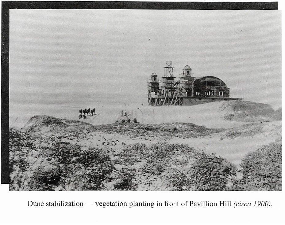
11 When looking at these pictures, one must ask, How were these dunes formed and what was the sequence of events to get them where they are today. The Dune Center offers an excellent video on the formation of the entire Nipomo Dunes complex. This video depicts sand moving down the Santa Maria River and into the ocean over many thousands of years. The sand is then washed up onto the shore, dried, and then blown inland forming the dunes. Thousands of years of this activity have created these dunes. Now one must ask which came first, the sand or the vegetation? This question is similar to the chicken and the egg. The old photos and written word give a better understanding of what natural is. The Pavilion Hill area is one of the best-known locations within the dunes. It was this location that locals brought wood and nails down with horse and wagon to build the large two-story Pavilion in the early 1900 s. In addition, plots of land could be purchased in the El Pizmo Beach Resort. Some people still own plots in this area from the old El Pizmo Beach Resort.. Page 11 of 22

12 Page 12 of 22


13 Note lack of vegetation in front of the Pavilion in this photo. Page 13 of 22


14 Note the vegetation added to stabilize the dunes. Page 14 of 22
15 The book, The Duneites, was written by Norm Hammond and was published by the South County Historical Society in The Duneites gives considerable history for the dunes and surrounding area, while focusing on some early inhabitants of the dunes. It is a great book and worthwhile for all to read. Page 12 of the Duneites reads: Work began on a grand pavilion at La Grande; the new pavilion would be larger and more expensive than the one at Oceano. It would stand in the heart of La Grande Estates, on the highest dune in the five-mile stretch of sand between Oceano and Oso Flaco Lake. The pavilion would face the ocean, just a few hundred yards from crashing surf. Page 13 of the Duneites reads: Succulent ice plant and European dune grass were planted in the huge dune at La Grande to stabilize the moving sand and prevent wind from cutting the foundations Page 13 of the Duneites reads: The grand opening was scheduled for July 4, Local papers carried advertisements promoting a free barbecue, clambake, horse racing and dancing all day. Page 13 of the Duneites reads: By 1915, the La Grande Pavilion and its pier stood deserted and in ruins. Page 14 of the Duneites reads: The sea wind cut through the dune grass and iceplant. It cut a small notch next to the redwood foundation of the pavilion and slowly widened until a man on horseback could ride beneath its northwest corner. The foundation weakened, and the northwest tower of the pavilion began leaning over into the wind. It creaked and swayed for months, until the final grain of sand had been whisked away, letting the ornate tower collapse sadly in the night. As one moves south along the coast and looks at some of the older pictures, one can see the beach has always had areas of barren sand. Page 15 of 22

16 The vegetation island that protrudes out towards the water (near the center of the photo) is referred to as Pavilion Hill. Pavilion Hill is where a dance hall was built in the early 1900 s. The builders of the Pavilion, trying to stabilize the dune, planted the large amount of vegetation. Note the lack of foredunes up and down the coast. Page 16 of 22

17 Moving further south. Pavilion Hill is at the bottom of this photo (north). Page 17 of 22

18 At the top of this photo is Oso Flaco Creek. Page 18 of 22
.")
19 In the middle of this photo, one can see Oso Flaco Creek. Note the lack of vegetation in the dunes above the creek (south). Page 19 of 22


20 This photo was taken September 5, This is Oso Flaco Creek note the beginning of massive amounts of vegetation smothering the dunes. Oso Flaco Creek on the left looking south. Page 20 of 22


21 South of the Oso Flaco Creek. Page 21 of 22
22 Friends of Oceano Dunes is deeply concerned that the APCD is ignoring historical evidence which supports barren dunes as being natural. Sand blowing is also natural and is the basis for making the sand dunes, which also includes the Nipomo Mesa. Sincerely, Jim Suty President Friends of Oceano Dunes CC: Tom Roth FRIENDS Board of Directors Page 22 of 22
Visitor s Survey Summary for the Pismo State Beach and Oceano Dunes State Vehicular Recreation Area Public Works Plan and Environmental Impact Report
 January 2019 Visitor s Survey Summary for the Pismo State Beach and Oceano Dunes State Vehicular Recreation Area Public Works Plan and Environmental Impact Report Prepared for: California Department of
Oceano Dunes SVRA (Pismo Beach)
") SCLR Event Oceano Dunes SVRA (Pismo Beach) September 19-20, 2009 When: Where: What: September 19 nd and 20 th Oceano Dunes SVRA Pismo Beach, California Sand Dunes, camping, games, food, driving challenges,
SCLR Event Oceano Dunes SVRA (Pismo Beach) September 19-20, 2009 When: Where: What: September 19 nd and 20 th Oceano Dunes SVRA Pismo Beach, California Sand Dunes, camping, games, food, driving challenges,
Section 3.9 Recreation
 3.9. 1 Introduction Section 3.9 Recreation This analysis provides a brief overview of existing recreational uses of Rancho Guadalupe Dunes County Park and recreational facilities in the general vicinity,
Silver Lake Park An Environmental Jewel for the Citizens of Prince William County
 Silver Lake Park An Environmental Jewel for the Citizens of Prince William County The Prince William Park Authority Mission Statement states: The Prince William County Park Authority will create quality
TRAIL USER PERMIT FEE NATURAL RESOURCES, AGRICULTURE AND ENVIRONMENT INTERIM COMMITTEE
 TRAIL USER PERMIT FEE NATURAL RESOURCES, AGRICULTURE AND ENVIRONMENT INTERIM COMMITTEE Chris Haller Off-highway Vehicle Program Manager and Recreation Why? Motorized (Off-highway Vehicle-OHV) community
COASTAL CONSERVANCY. Staff Recommendation June 5, 2008 GUALALA BLUFF TRAIL OPERATIONS AND MAINTENANCE
 COASTAL CONSERVANCY Staff Recommendation June 5, 2008 GUALALA BLUFF TRAIL OPERATIONS AND MAINTENANCE File No. 08-047-01 Project Manager: Deborah Hirst RECOMMENDED ACTION: Consideration and possible Conservancy
March 14, SUBJECT: Public input to the Bureau of Land Management, Gunnison Field Office, Travel Management Plan
 March 14, 2019 Delivered via email to ewaters@blm.gov Elijah Waters Field Manager BLM Gunnison Field Office Gunnison, CO 81230 SUBJECT: Public input to the Bureau of Land Management, Gunnison Field Office,
112th CONGRESS. 1st Session H. R. 113 IN THE HOUSE OF REPRESENTATIVES
 HR 113 IH 112th CONGRESS 1st Session H. R. 113 To provide for additions to the Cucamonga and Sheep Mountain Wilderness Areas in the Angeles and San Bernardino National Forests and the protection of existing
 March 25, 1994 To: Re: MEMO TO FILE MINOR AMENDMENT - PINERY PROVINCIAL PARK MANAGEMENT PLAN The following paragraph from page 5 of the Pinery Provincial Park Management Plan (ISBN 0-7729-0290-9) lnsects
APPENDIX E. San Luis Obispo County Coastal Plan Recreational and Visitor Serving Policies SLO North Coast Scenic Byway Corridor Plan
 APPENDIX E San Luis Obispo County Coastal Plan Recreational and Visitor Serving Policies 60 - SLO North Coast Scenic Byway Corridor Plan CHAPTER 3: RECREATION & VISITOR-SERVING FACILITIES INTRODUCTION
NAVAJO COMMUNITY PLAN
 NAVAJO COMMUNITY PLAN Prepared by the NAVAJO COMMUNITY PLANNERS and THE CITY OF SAN DIEGO City of San Diego Planning Department 202 C Street, MS 4A San Diego, CA 92101 Printed on recycled paper. This information,
Attachments: Negative Declaration Initial Study (CEQA 15073(c))
)") NOTICE OF AVAILABILITY AND INTENT TO ADOPT AN INITIAL STUDY/NEGATIVE DECLARATION DUTRA ESTATES UNIT 5 GENERAL PLAN AMENDMENT, REZONE, TENTATIVE SUBDIVISION MAP, PLANNED DEVELOPMENT AMENDMENT, & DEVELOPMENT
NOTICE OF AVAILABILITY AND INTENT TO ADOPT AN INITIAL STUDY/NEGATIVE DECLARATION DUTRA ESTATES UNIT 5 GENERAL PLAN AMENDMENT, REZONE, TENTATIVE SUBDIVISION MAP, PLANNED DEVELOPMENT AMENDMENT, & DEVELOPMENT
CITY OF PALMDALE. REPORT to the Mayor and Members of the City Council from the City Manager
 CITY OF PALMDALE REPORT to the Mayor and Members of the City Council from the City Manager DATE: June 4, 2014 SUBJECT: Specific Plan Amendment 14-01; Amending the Use Designation of 23.97 Acres within
Arthur Carhart National Wilderness Training Center s Wilderness Investigations High School
 Arthur Carhart National Training Center s Investigations High School 101/Lesson 2 (OPTION 2B) Introducing the Act Goal: Students will understand the difference between wild spaces and federally designated
TRAILS WHERE TO FIND TRAILS IN NOVA SCOTIA
 TRAILs SIGNAGE Know the Signs............................ 44 WHERE YOU CAN RIDE Roads and Highways........................ 46 Designated Trails........................... 47 Established Trails...........................
LAS VARAS RANCH CA COASTAL TRAIL PROPOSED ALIGNMENT
 LAS VARAS RANCH CA COASTAL TRAIL PROPOSED ALIGNMENT Santa Barbara Trails Council * Prepared by Ray Ford February 1,2012 The following notes accompany the Santa Barbara Trails Council map for the Las Varas
FINAL TESTIMONY 1 COMMITTEE ON RESOURCES UNITED STATES HOUSE OF REPRESENTATIVES. July 13, 2005 CONCERNING. Motorized Recreational Use of Federal Lands
 FINAL TESTIMONY 1 STATEMENT OF DALE BOSWORTH CHIEF Of the FOREST SERVICE UNITED STATES DEPARTMENT OF AGRICULTURE Before the SUBCOMMITTEE ON FORESTS AND FOREST HEALTH And the SUBCOMMITTEE ON NATIONAL PARKS,
Public Comment. Comment To consider extending State Park lands above River Mile 7.0
 Public To consider extending Park lands above River Mile 7.0 on the Little Spokane River for the conservation and limited recreation qualities they contain is this request. Could this be included in your
EXECUTIVE SUMMARY PROGRAM DEVELOPMENT REPORT PURPOSE EXISTING SETTING EXPANDING PARKLAND
 EXECUTIVE SUMMARY PROGRAM DEVELOPMENT REPORT PURPOSE As the culmination of the first phase of the master planning process, this Program Development Report creates the framework to develop the Calero County
Welcome to Marco Island
 Marco Island is located in Southwest Florida, on the Gulf of Mexico, 178 miles south of Tampa,16 miles south of Naples, and 104 miles due west of Miami. Marco is the northern most and largest of the famous
WORKSHEET 24: Sand dunes - Conservation and management
 SAND DUNES - CONSERVATION AND MANAGEMENT MEETING THE CHALLENGE Sand dunes are: Excellent natural protection for the land A great recreational and educational area A specialised wildlife habitat But they
COASTAL CONSERVANCY. Staff Recommendation December 2, 2004 COYOTE HELLYER COUNTY PARK BAY AREA RIDGE TRAIL
 COASTAL CONSERVANCY Staff Recommendation December 2, 2004 COYOTE HELLYER COUNTY PARK BAY AREA RIDGE TRAIL File No. 04-057 Project Manager: Amy Hutzel RECOMMENDED ACTION: Authorization to disburse up to
Chuckanut Ridge Fairhaven Highlands EIS Scoping Concerns
 Chuckanut Ridge Fairhaven Highlands EIS Scoping Concerns Coalition of Southside Neighborhoods CSN Comments for Fairhaven Highlands EIS Scope Hearing, Jan 16, 2008 1 Chuckanut Ridge Hilly Terrain: Potential
April 10, Mark Stiles San Juan Public Lands Center Manager 15 Burnett Court Durango, CO Dear Mark,
 Mark Stiles San Juan Public Lands Center Manager 15 Burnett Court Durango, CO 81301 Dear Mark, We are pleased to offer the following comments on the draft San Juan Public Lands Center management plans
Creating a User-Driven Long-Distance OHV Trail Through Partnering
 Joseph Raffaele Outdoor Recreation Planner U.S. Bureau of Land Management Yuma, Arizona Creating a User-Driven Long-Distance OHV Trail Through Partnering BLM is a multiple-use land management agency within
Chatsworth Branch Library Devonshire Street, Chatsworth, CA Thursday, November 16, :00-8:00 pm
 Chatsworth Branch Library 21052 Devonshire Street, Chatsworth, CA 91311 Thursday, November 16, 2017 6:00-8:00 pm Project Team County of Los Angeles Department of Parks and Recreation Kathline King Chief
Mt. Hood National Forest
 United States Department of Agriculture Forest Service Mt. Hood National Forest Zigzag Ranger District 70220 E. Highway 26 Zigzag, OR 97049 503-622-3191 Fax: 503-622-5622 File Code: 1950-1 Date: June 29,
PLANNING AND ZONING COMMISSION PUBLIC WORKSHOP ON TRAFFIC AND NUISANCE IMPACTS FROM MINING
 PLANNING AND ZONING COMMISSION PUBLIC WORKSHOP ON TRAFFIC AND NUISANCE IMPACTS FROM MINING There was a meeting of the Indian River County (IRC) Planning and Zoning Commission (P&Z) on Thursday, May 22
USDA Forest Service Deschutes National Forest DECISION MEMO. Round Lake Christian Camp Master Plan for Reconstruction and New Facilities
 USDA Forest Service Deschutes National Forest DECISION MEMO Round Lake Christian Camp Master Plan for Reconstruction and New Facilities Jefferson County, Oregon T. 13 S., R. 8 E., Section 16, W.M. Background:
Stagecoach State Trail Master Plan
 Stagecoach State Trail Master Plan Minnesota Minnesota Department Department of of Natural Natural Resources Resources Parks and and Trails Trails Division Division Parks March March 2012 2012 The Minnesota
Stevenson Ranch Library The Old Road, Stevenson Ranch, CA Thursday, November 9, :00-8:00 pm
 Stevenson Ranch Library 25950 The Old Road, Stevenson Ranch, CA 91381 Thursday, November 9, 2017 6:00-8:00 pm Project Team County of Los Angeles Department of Parks and Recreation Kathline King Chief of
ROAD AND TRAIL PROJECT APPROVAL
 ROAD AND TRAIL PROJECT APPROVAL www.marincountyparks.org Marin County Parks, 3501 Civic Center Dr, Suite 260, San Rafael, CA 94903 DATE: July 12, 2017 PRESERVE: Gary Giacomini Open Space Preserve PROJECT:
Alternative 3 Prohibit Road Construction, Reconstruction, and Timber Harvest Except for Stewardship Purposes B Within Inventoried Roadless Areas
 Roadless Area Conservation FEIS Summary Table S-1. Comparison of Key Characteristics and Effects by Prohibition Alternative. The effects summarized in this table A would occur in inventoried roadless areas
ORDINANCE NO
 ORDINANCE NO. 2002-123 ORDINANCE OF THE CITY COUNCIL OF THE CITY OF LAGUNA NIGUEL, CALIFORNIA, ADOPTING MODEL GLIDER FLYING REGULATIONS FOR LILLY SHAPELL PARK The City Council of the City of Laguna Niguel
Proposal to Redevelop Lower Kananaskis River-Barrier Lake. Bow Valley Provincial Park
 Frequently Asked Questions Proposal to Redevelop Lower Kananaskis River-Barrier Lake Bow Valley Provincial Park Frequently Asked Questions What has been decided? What are the details of the plan? What
the pacific coast scenic tour from southern california to alaska the canadian pacific railway yellowstone park and the grand ca on with illustrations
 DOWNLOAD OR READ : THE PACIFIC COAST SCENIC TOUR FROM SOUTHERN CALIFORNIA TO ALASKA THE CANADIAN PACIFIC RAILWAY YELLOWSTONE PARK AND THE GRAND CA ON WITH ILLUSTRATIONS PDF EBOOK EPUB MOBI Page 1 Page
Gawler Environment and Heritage Association Inc, C/- 42 Finniss Street Gawler SA 5118
 Gawler Environment and Heritage Association Inc, C/- 42 Finniss Street Gawler SA 5118 4 April 2008 Mr Richard Osborne General Manager SA Delfin Lend Lease 1 Main Street Mawson Lakes SA 5106 cc Ms Maria
Roduner Ranch FOR SALE. 5,878± Acres Potential Development Land. Merced County, California. Offices Serving The Central Valley
 FOR SALE 5,878± Acres Potential Development Land Merced County, California Offices Serving The Central Valley F R E S N O V I S A L I A B A K E R S F I E L D 7480 N. Palm Ave, Ste 101 3447 S. Demaree Street
Continental Divide National Scenic Trail Legislative History and Planning Guidance
 Continental Divide National Scenic Trail Legislative History and Planning Guidance Legislation, Policy, and Direction Regarding National Scenic Trails The National Trails System Act, P.L. 90-543, was passed
Yucca Mountain Nuclear Fuel Locations and Associated Rail Facilities. Diablo Canyon Power Plant, California
 Yucca Mountain Nuclear Fuel Locations and Associated Rail Facilities Diablo Canyon Power Plant, California Yucca Mountain: Nuclear Fuel Locations and Associated Rail Facilities October 1, 2010 Final Report
David Johnson. Tom, Attached please find the final scoping letter and figures for your review. David
 David Johnson From: Sent: To: Cc: Subject: Attachments: David Johnson Tuesday, April 12, 2011 4:33 PM Thomas Malecek Dave Dyer; Jason Marks (jmarks@segroup.com) VWC Scoping Letter
Logo Department Name Agency Organization Organization Address Information 5700 North Sabino Canyon Road
 Logo Department Name Agency Organization Organization Address Information United States Forest Coronado National Forest 5700 North Sabino Canyon Road Department of Service Santa Catalina Ranger District
National Wilderness Steering Committee
 National Wilderness Steering Committee Guidance White Paper Number 1 Issue: Cultural Resources and Wilderness Date: November 30, 2002 Introduction to the Issue Two of the purposes of the National Wilderness
Proposal to Redevelop Lower Kananaskis River-Barrier Lake. Bow Valley Provincial Park. Frequently Asked Questions
 Proposal to Redevelop Lower Kananaskis River-Barrier Lake Bow Valley Provincial Park Frequently Asked Questions What is being proposed? What are the details of the proposal? Where is the project area located?
CITY OF PALMDALE LOS ANGELES COUNTY, CALIFORNIA RESOLUTION NO. CC
 CITY OF PALMDALE LOS ANGELES COUNTY, CALIFORNIA RESOLUTION NO. CC 2010-087 A RESOLUTION OF THE CITY COUNCIL OF THE CITY OF PALMDALE, CALIFORNIA, APPROVING SPECIFIC PLAN AMENDMENT 10-01, AMENDING THE PALMDALE
The rezoning application is recommended for consideration of approval.
 Date: November 26, 2012 To: From: Chairperson and Members Planning and Housing Committee Ken O Brien, MCIP Manager of Planning & Information Cliff Johnston, MCIP Director of Planning Re: Department of
Proposed Action. Payette National Forest Over-Snow Grooming in Valley, Adams and Idaho Counties. United States Department of Agriculture
 United States Department of Agriculture Forest Service January 2012 Proposed Action Payette National Forest Over-Snow Grooming in Valley, Adams and Idaho Counties Payette National Forest Valley, Adams
NORTH HEMPSTEAD BEACH PARK MASTER PLAN
 NORTH HEMPSTEAD BEACH PARK MASTER PLAN COMMUNITY DESIGN CHARRETTE Supervisor Judi Bosworth Viviana L. Russell Peter J. Zuckerman Angelo P. Ferrara Anna M. Kaplan Lee R. Seeman Dina M. De Giorgio VISIONING
13.1 REGIONAL TOURISM ISSUES AND SUMMARY OF FINDINGS
 13 REGIONAL TOURISM T he County of Mariposa s recreation needs and facilities fall within two categories: regional tourism and local recreation. This Element focuses on regional tourism issues related
Thank you for this second opportunity to comment on the proposed revisions to the Coconino National Forest Management plan.
 March 8, 2011 Flagstaff Biking Organization PO Box 23851 Flagstaff, AZ 86002 Yewah Lau Coconino National Forest Attn: Plan Revision 1824 South Thompson Street Flagstaff, Arizona 86001 Sent via electronic
Pinellas County Environmental Lands
 Pinellas County Environmental Lands In addition to traditional parks and recreation facilities, Pinellas County owns and manages a system of environmental lands that provides specialized resource-based
A CASE FOR COMPLETING THE JORDAN RIVER PARKWAY: A
 A CASE FOR COMPLETING THE JORDAN RIVER PARKWAY: A safe crossing at 9000 South and 850 West Proposed 9000 South Underpass Parkway Timeline Parkway, Trail, and Tourism Facts Blueprint Jordan River 1971 1973
Hickman s (Diamond) Mills
 Mills") Hickman s (Diamond) Mills On the east branch of Naaman's Creek, near the northwest boundary of Lower (and Upper) Chichester townships, was the saw- and grist-mill of Samuel Hickman, which was one of the
Hickman s (Diamond) Mills On the east branch of Naaman's Creek, near the northwest boundary of Lower (and Upper) Chichester townships, was the saw- and grist-mill of Samuel Hickman, which was one of the
The following criteria were used to identify Benchmark Areas:
 7.0 BENCHMARK AREAS The Churn Creek Protected Area offers a significant opportunity to learn more about how grassland ecosystems function. One of the key tools that will be used to monitor larger grassland
STREAKED HORNED LARK. Conservation of a threatened species in an industrial landscape. Cat Brown US Fish and Wildlife Service
 STREAKED HORNED LARK Conservation of a threatened species in an industrial landscape Cat Brown US Fish and Wildlife Service HISTORICAL & CURRENT RANGE Streaked Horned Lark Distribution Historical Range:
FEASIBILITY CRITERIA
 This chapter describes the methodology and criteria used to evaluate the feasibility of developing trails throughout the study areas. Land availability, habitat sensitivity, roadway crossings and on-street
San Luis Obispo. Bishop Peak Felsman Loop Eagle Rock Maino Open Space Poly Canyon Poly P Other Areas
 San Luis Obispo Bishop Peak Felsman Loop Eagle Rock Maino Open Space Poly Canyon Poly P Other Areas 1 JCT. ELEV. 72 400 00 0 FELSMAN LOOP GATE LOOP RIDGE 600 FENCE JCT. ELEV. 860 1000 1200 BISHOP PEAK
Redesigning The Waterfront
 San Francisco Maritime National Park Service U.S. Department of the Interior National Historical Park California Redesigning The Waterfront A Self-Guided Walking Tour Then & Black Point Cove, ca. 1910.
WASHINGTON STATE PARKS LAND CLASSIFICATION SYSTEM
 WASHINGTON STATE PARKS LAND CLASSIFICATION SYSTEM Administrative Code Establishing Land Classification System WAC 352-16-020 Land classification system. State park areas are of statewide natural, cultural,
PROPOSED PARK ALTERNATIVES
 8 Chimne y Rock State Park M a ster Pl an 2011 PROPOSED PARK ALTERNATIVES Introduction Three different park development concepts were prepared and presented to the citizens of North Carolina through a
The Roots of Carrying Capacity
 1 Applying Carrying Capacity Concepts in Wilderness 1872 1964...shall be preserved for the use & enjoyment of the American people...in such manner as will leave them unimpaired for future generations...
Port Bruce. Interim Management Statement
 Port Bruce Interim Management Statement Port Bruce Interim Management Statement August 3, 1999 This Port Bruce Provincial Park Interim Management Statement provides direction for the custodial management
Chapter 1: Introduction
 Chapter 1: Purpose of the Comprehensive Plan The purpose of the Comprehensive Plan of the City of Rockaway Beach is to provide a policy guide for the growth and future development of the City. Section
Lake Myra County Park. Wake County, North Carolina Community Forum #2 June 12, 2008
 Lake Myra County Park Wake County, North Carolina Community Forum #2 June 12, 2008 Welcome and Introduction Meeting Agenda Welcome Introductions of Project Team Master Plan Process Community Forum #1 Updates
Society Member to Supervise the Building of James Monroe s Birthplace House Charles Belfield, a councilor of the War of 1812 Society in the
 Society Member to Supervise the Building of James Monroe s Birthplace House Charles Belfield, a councilor of the War of 1812 Society in the Commonwealth of Virginia has been designated as the supervisor
National Forests and Grasslands in Texas
 United States Department of Agriculture Forest Service National Forests and Grasslands in Texas Sam Houston NF 394 FM 1375 West New Waverly, Texas 77358 Phone 936-344-6205 Dear Friends, File Code: 1950
Monterey Coast-Sierra de Salinas Linkage Study. Conducted by The Big Sur Land Trust & Pathways for Wildlife
 Monterey Coast-Sierra de Salinas Linkage Study Conducted by The Big Sur Land Trust & Pathways for Wildlife Objectives & Goals 1) To increase our understanding of wildlife movement throughout the Central
Alternative Highest & Best Use Analysis Boutique Hotel
 Alternative Highest & Best Use Analysis In response to numerous comments received from the public, as well as issues raised by the CCC in the Appeal Staff Report Substantial Issue Determination, the following
Applying Carrying Capacity Concepts in Wilderness
 Applying Carrying Capacity Concepts in Wilderness...shall be preserved for the use & enjoyment of the American people...in such manner as will leave them unimpaired for future generations... CSS 490 Professor
Land Use. Grasslands and Rangelands National Parks and Reserves. Thursday, October 9, 14
 Land Use Grasslands and Rangelands National Parks and Reserves MANAGING AND SUSTAINING GRASSLANDS Almost half of the world s livestock graze on natural grasslands (rangelands) and managed grasslands (pastures).
2. Goals and Policies. The following are the adopted Parks and Trails Goals for Stillwater Township:
 D. PARKS AND TRAILS 1. Introduction Stillwater Township s population is relatively low, with most residents living on rural residences on large lots. The need for active park space has been minimal in
Chapter 6: POLICY AND PROCEDURE RECOMMENDATIONS
 Chapter 6 POLICY AND PROCEDURE RECOMMENDATIONS FOR SRRA Below are seven policy elements that should be considered for adoption by the Southwest Regional Recreation Authority of Virginia: 1. Develop strategies
H. R IN THE HOUSE OF REPRESENTATIVES
 I 113TH CONGRESS 1ST SESSION H. R. 1776 To establish the Clear Creek National Recreation Area in San Benito and Fresno Counties, to designate the Joaquin Rocks Wilderness in such counties, to designate
(Short Listing) DUPUYER ACREAGE, ROCKY MOUNTAN FRONT
 DUPUYER ACREAGE, ROCKY MOUNTAN FRONT") (Short Listing) DUPUYER ACREAGE, ROCKY MOUNTAN FRONT This unique property is located 8½ miles northwest of Dupuyer, Montana and approximately thirty 30 miles northwest of Choteau, Montana. Great Falls
(Short Listing) DUPUYER ACREAGE, ROCKY MOUNTAN FRONT This unique property is located 8½ miles northwest of Dupuyer, Montana and approximately thirty 30 miles northwest of Choteau, Montana. Great Falls
Finn Creek Park. Management Direction Statement Amendment
 Finn Creek Park Management Direction Statement Amendment November 2013 Management Direction Statement Amendment Approved by: Jeff Leahy Regional Director, Thompson Cariboo BC Parks November 12, 2013 Date
(apr l(x)irrnr. brttctx5~~ (H+H J )TVH~HTH. national Seaside. sjludu rora.
irrnr. brttctx5~~ (H+H J )TVH~HTH. national Seaside. sjludu rora.") r sjludu rora. national Seaside IU Inc/uatitq (H+H J )TVH~HTH brttctx5~~ (apr l(x)irrnr BRAnOfOFPLflnninG-nflTIOIlAL. PARK SERVICE D E PflRT m E n T OF TH E I n T E RIOK. NATIONAL SEASHORE PJSCriiATIOIIAL
r sjludu rora. national Seaside IU Inc/uatitq (H+H J )TVH~HTH brttctx5~~ (apr l(x)irrnr BRAnOfOFPLflnninG-nflTIOIlAL. PARK SERVICE D E PflRT m E n T OF TH E I n T E RIOK. NATIONAL SEASHORE PJSCriiATIOIIAL
CHAPTER 4 -- THE LAND USE PLAN: DESCRIPTIONS AND POLICIES FOR THIRTEEN PLANNING AREAS
 CHAPTER 4 -- THE LAND USE PLAN: DESCRIPTIONS AND POLICIES FOR THIRTEEN PLANNING AREAS SOUTH COAST CAC PLANNING AREA 4.10 NAVARRO RIVER TO MALLO PASS CREEK PLANNING AREA (Includes Greenwood/Elk) This planning
Francis Marion and Sumter National Forests
 United States Department of Agriculture Forest Service Francis Marion and Sumter National Forests 2967 Steed Creek Rd. Huger, SC 29450 Tele: (843)336-2200 File Code: 1950 Date: February 13, 2015 To Whom
THAT the Board approve the final proposed concept plan for the Jericho Marginal Wharf site as shown in Figure C-4 of Appendix C.
 Date: January 17, 2012 TO: Board Members Vancouver Park Board FROM: General Manager Parks and Recreation SUBJECT: Jericho Marginal Wharf Phase 2 Concept Plan RECOMMENDATION THAT the Board approve the final
F.J. Martin Roberts Evening (Mt Coot-tha from Dutton Park) 1898
 1898") F.J. Martin Roberts Evening (Mt Coot-tha from Dutton Park) 1898 A Deed of Grant in Trust protecting Mt Coot-tha was enacted in 1880 after community pressure, the reserve to be managed as a public park
F.J. Martin Roberts Evening (Mt Coot-tha from Dutton Park) 1898 A Deed of Grant in Trust protecting Mt Coot-tha was enacted in 1880 after community pressure, the reserve to be managed as a public park
Rule Governing the Designation and Establishment of All-Terrain Vehicle Use Trails on State Land
 Rule Governing the Designation and Establishment of All-Terrain Vehicle Use Trails on State Land 1.0 Authority 1.1 This rule is promulgated pursuant to 23 V.S.A. 3506. Section 3506 (b)(4) states that an
DATE: January 19, WCA Governing Board. Johnathan Perisho, Project Manager. Mark Stanley, Executive Officer
 Item 14 DATE: January 19, 2017 TO: FROM: THROUGH: SUBJECT: WCA Governing Board Johnathan Perisho, Project Manager Mark Stanley, Executive Officer Item 14: Consideration of a resolution to accept an acquisition
For Sale Downtown Professional Office Building 4,500 SF Stand Alone Building
 For Sale Downtown Professional Office Building 4,500 SF Stand Alone Building San Luis Obispo, California Preston Thomas, SIOR 805.544.3900 office preston@rossetticompany.com BRE Lic. #01378821 Professional
1803 West Hwy 160 Monte Vista, CO (719) TTY (719)
 TTY (719)") USDA Forest Service Rio Grande National Forest http://www.fs.fed.us/r2/riogrande 1803 West Hwy 160 Monte Vista, CO 81144 (719)852-5941 TTY (719)852-6271 USDI Bureau of Land Management San Luis Valley Center
USDA Forest Service Rio Grande National Forest http://www.fs.fed.us/r2/riogrande 1803 West Hwy 160 Monte Vista, CO 81144 (719)852-5941 TTY (719)852-6271 USDI Bureau of Land Management San Luis Valley Center
Clearwater Lake Provincial Park. Draft Management Plan
 Clearwater Lake Provincial Park Draft Management Plan Clearwater Lake Provincial Park Draft Management Plan Table of Contents 1. Introduction... 3 2. Park History... 4 3. Park Attributes... 4 3.1 Location/Access...4
Stakeholder Engagement Session Report Motorized Trail Users Evergreen TEC Centre April 27,, 2010
 10001 84 Avenue Clairmont, AB T0H 0W0 Tel. 780-513-3950 email: wcps@wapiticorridor.ca Web site: www.wapiticorridor.ca Stakeholder Engagement Session Report Motorized Trail Users Evergreen TEC Centre April
LEAVE NO TRACE CENTER FOR OUTDOOR ETHICS CONSULTING SERVICES
 LEAVE NO TRACE CENTER FOR OUTDOOR ETHICS CONSULTING SERVICES LEAVE NO TRACE PURPOSE Americans love the outdoors. Today, more than 300 million people visit America s national parks and another 150 million
MUCH HADHAM PARISH COUNCIL
 MUCH HADHAM PARISH COUNCIL MINUTES of the Much Hadham Parish Council meeting held on Tuesday, 6 January 2015, in the Much Hadham Village Hall at 7.30 pm. *Cllr Mrs S Bannerman *Cllr A Baxter *Cllr T Baxter
Thank you for this third opportunity to comment on the proposed revisions to the Coconino National Forest Management plan.
 March 19, 2014 Flagstaff Biking Organization PO Box 23851 Flagstaff, AZ 86002 Vern Keller Coconino National Forest Attn: Plan Revision 1824 South Thompson Street Flagstaff, Arizona 86001 coconino_national_forest_plan_revision_team@fs.fed.us
Town of Perryville Town Meeting Minutes July 2, The Town of Perryville Town Meeting was called to order at 7:00 p.m. by Mayor Eberhardt.
 Town of Perryville Town Meeting Minutes ATTENDANCE: Mayor: James Eberhardt, Commissioners: Barbara Brown, Alan Fox, Ray Ryan, Town Administrator: Denise Breder and Police Chief Wernz. The Town of Perryville
Bainbridge Ranch Cape Girardeau - Missouri Listed at $9,000,
 Bainbridge Ranch Cape Girardeau - Missouri Listed at $9,000,000.00 -------------------------------------------------------------------------------- Bainbridge Ranch (+/- 1595 acres) is a unique and impressive
RESOLUTION OF THE BOARD OF SUPERVISORS OF ORANGE COUNTY, CALIFORNIA. February 14, 2017
 RESOLUTION OF THE BOARD OF SUPERVISORS OF ORANGE COUNTY, CALIFORNIA February 14, 2017 WHEREAS, the County of Orange ( County ), through the Board of Supervisors ( Board ), is the owner and operator of
White Mountain National Forest Saco Ranger District
 United States Department of Agriculture Forest Service White Mountain National Forest 33 Kancamagus Highway Conway, NH 03818 Comm: (603) 447-5448 TTY: (603) 447-3121 File Code: 1950 Date: February 26,
B10. Agate Beach State Recreation Site
 B10. Agate Beach State Recreation Site Location Within the City of Newport, just south of the Yaquina Head Outstanding Natural Area. The park is located along the west side of Highway 101 at the mouth
STORNETTA BROTHERS COASTAL RANCH
 STORNETTA BROTHERS COASTAL RANCH Location: Surrounding Point Arena Lighthouse and immediately south of Manchester State Park Mendocino Co., CA Acres: 1,860 Resources: Over two miles of Pacific Ocean coastline
ORDINANCE NO. 418 BE IT ORDAINED BY THE MAYOR AND COUNCIL OF THE CITY OF MACKAY, CUSTER COUNTY, IDAHO:
 ORDINANCE NO. 418 AN ORDINANCE OF THE CITY OF MACKAY, CUSTER COUNTY, STATE OF IDAHO, REPEALING CITY OF MACKAY ORDINANCE NUMBER 337; DEFINING RECREATIONAL VEHICLES (RV'S), AND RECREATIONAL VEHICLE PARK;
BUCKEYE LAKE PROTECTION PLAN THE TOWN OF BEECH MOUNTAIN REGULATIONS GOVERNING IN-LAKE ACTIVITIES AND USES OF BUCKEYE LAKE
 I. PURPOSE BUCKEYE LAKE PROTECTION PLAN THE TOWN OF BEECH MOUNTAIN REGULATIONS GOVERNING IN-LAKE ACTIVITIES AND USES OF BUCKEYE LAKE The purpose of this regulation is to set forth for the Town of Beech
Understanding the caring capacity of the visitor experience Provide facilities to support a high level user experience Address visual quality through
 Understanding the caring capacity of the visitor experience Provide facilities to support a high level user experience Address visual quality through recreation ecological restoration opportunities Collaboration
National Park Service Wilderness Action Plan
 National Park Service U.S. Department of the Interior National Park Service Wilderness Action Plan National Wilderness Steering Committee National Park Service "The mountains can be reached in all seasons.
Eastern Lake Ontario Beach User Survey 2003/2004.
 Eastern Lake Ontario Beach User Survey 2003/2004. Introduction The eastern shore of Lake Ontario is a Biodiversity Investment Area that features a 17-mile long barrier beach of Great Lakes dunes and a