Back River Trail. Master Plan and Design Guidelines
|
|
|
- Alexia Baldwin
- 6 years ago
- Views:
Transcription


1
2 Back River Trail Master Plan and Design Guidelines Prepared for: Conservation Commission Department of Planning and Community Development Town of Weymouth, MA Prepared by: ICON parks design August 8, 2005
3 Table of Contents List of Illustrations 2 List of Appendices 3 Back River Trail: Introduction 4 Back River Trail: History 5 Trail Design Summary: 6 Planning Goals: 9 Interpretive Framework: 10 Way Finding and Interpretive System: 10 Gateway Interpretive Story and Themes 14 Trail Phasing 22 Phase I 23 Phase II 31 Phase III 37 Early Action Phase: 39 Beyond Phased Improvements: 40 Trail Funding Opportunities: 41 Environmental Permitting: 43
4 List of Illustrations Figure 1 Back River Trail Plan 8 Figure 2a/2b Logo Options 10 Figure 3 Gateway Sign 11 Figure 4 Interpretive Panel 12 Figure 5 Directional Sign 13 Figure 6 Trail Marker 13 Figure 7 Gateway Locations 14 Figure 8 Herring Run Gateway Kiosk 16 Figure 9 Durante Property Site Plan 25 Figure 10 Kayak Launching Site 26 Figure 11 Kayak Launch Site Details 26 Figure 12 MBTA Parking Lot 27 Figure 13 MBTA Parking Lot Alternate Route 29 Figure 14 Interactive Wall Sculpture 32 Figure 15 Herring Run Pool Park Alternate A 32 Figure 16 Herring Run Pool Park Alternate B 33 Figure 17 Iron Hill Park 35 Figure 18 Decorative Iron Gateway 36 Figure 19 Preferred On-Street Connection 37 Figure 20 Boardwalk Under Rt. 3A 38 Figure 21 Boardwalk Plan and Section 38 Figure 22 Possible Gateway Option 39 Figure 23 Regional Bike Routes 41 Additional Historic and Existing Condition Photographs are included within the report but are not listed herein. 2
5 List of Appendices Appendix A: Appendix B: Appendix C: Appendix D: Appendix E: Appendix F: Appendix G: Appendix H: Summary Cost Estimate Detailed Cost Estimate Trail Design Guidelines and Maintenance/Upgrade of Existing Trail Stopping Sight Distances for Paved Shared Use Paths Minimum Radii for Paved Shared Use Paths Minimum Length of Crest Vertical Curves (L) Based on Stopping Distance Stabilized Stone Dust Paving Construction Specifications Bike Trail Memos References 3
6 Back River Trail: Introduction In 2001, the Town completed and adopted a new Master Plan for Weymouth. One recommendation of the plan is to link open space parcels to create a pedestrian, bicycle trail system connecting currently isolated park areas and sections of the Town. The Town s first area of focus is to extend existing pathways in Great Esker Park to Abigail Adams State Park to the north and Whitman s Pond to the south. The Town issued a Request for Proposals for planning and design firms to prepare a plan for the Back River Trail in late October, The proposed elements of the plan included pathways from Abigail Adams State Park to Whitman s Pond, new gateway access points and focal nodes, and signage interpreting the environmental and human history along the trail. ICON Parks Design of Dorchester, in collaboration with Howard/Stein Hudson Associates, Boston was chosen to prepare the plan. After initial fact gathering and reconnaissance, the Weymouth Conservation Commission hosted a presentation by the consultants and planning staff in June, The meeting was targeted to various stakeholders along the trail and, together with a generally favorable reaction to preliminary ideas, the consultants gathered valuable comments from those in attendance. The consultants compiled additional information throughout the fall and integrated presentation comments into the final plan. This Back River Trail Plan is a vision and a blueprint for creating a valuable trail system linking several of our most valuable scenic and environmental resource areas. The intent is to enhance opportunities to visit these areas while protecting the resources in these areas. The plan is organized to allow the Town to develop the trail system in segments and over time as funds become available. 4
7 Back River Trail: History The Back River Trail builds upon two natural landscapes along the northeast border of the Town; Great Esker Park and Weymouth Back River. Both were formed as the last glacier retreated from New England about 12,000 years ago. The esker formed from the remnants of sands and gravels in the bed of a meltwater stream within the glacier. This accounts for its long, sinewy form and unconsolidated materials. The Back River formed as glacial meltwater increased the ocean elevation and low lying coastal areas were flooded and became parts of the new coastline. The focal nodes of the Back River Trail have an interesting history. These six parcels have had, at one time in their history, active land uses that contributed to the development of the community. More communities are restoring abandoned industrial sites to park and recreation uses, but it s rare to see this many industrial sites converted and connected as a trail and park system. Starting at the southern terminus of the Back River Trail, Whitman s Pond and the proposed Iron Hill Park off Iron Hill Street were part of the iron industry in Weymouth. The present configuration of Whitman s Pond was created by the building of the dam to store water to power the machines used to turn iron ore, quartz, and coal into tools, utensils, and nails for the American public. The Weymouth Iron Works opened in 1837 and had its heyday in the late 1800 s. Although several buildings from this era remain, the main iron works buildings have been demolished, vacating the site for the proposed Iron Hill Park. The Herring Run Pool was the main location for catching herring from the Herring Run. Reference to the herring can be found as far back as the 1648 Town records. The Herring Run was a valuable food resource through the mid 1900 s and continues to thrive thanks to dedicated citizens of the Town. This site, which will be enhanced to showcase the migration of the herring, also housed the Town Youth and Family Services Office prior to its relocation to the former Police Station. This building has already been demolished by a local developer as part of a development agreement. Just north of the East Weymouth Station, adjacent to the Back River, is the site of the Weymouth Wool Scouring Mill. This complex covered most of the upland area from the late 1800 s through the mid twentieth century. This location also served as an off loading point for ships bringing coal and iron ore to the Weymouth Iron works. As part of the Greenbush mitigation package, the MBTA has purchased the property and will transfer it to the Town for use as a park. A portion of the site will be restored as salt marsh and the remaining area will be parkland with a small boat launch ramp to the Back River. Across the Back River from this property and north of the site is the former Town incinerator and landfill. Both are now closed and the landfill has been properly capped. The Back River Trail will continue north over the capped landfill, providing panoramic views of the Back River basin. 5
8 Great Esker Park has been preserved due to the intervention of the U.S. government in the early twentieth century. The land in Weymouth was acquired as a buffer for the ammunition depot across the Back River in Hingham. Because it served as a buffer, few alterations occurred on the property. After a four year effort by the Town, the federal government transferred the land for park purposes in 1966 for $112,500. The Town resisted suggestions to mine the gravel deposits and the land remains much as it did thousands of years ago. Across Bridge Street, the state has constructed the Abigail Adams State Park on land formerly occupied by an automobile dealership and a marine dredging operation. This passive park will be connected to the Back River Trail by a walkway under the Route 3A Bridge. Trail Design Summary: The Back River Trail will connect Abigail Adams State Park to the Iron Hill Fish Ladder site. The trail system is intended to be shared by walkers, bicyclists, joggers and strollers. The trail will pass under the Route 3A bridge utilizing a raised boardwalk that will provide panoramic views and accessibility for the handicapped. The current access to the trail at the northernmost end of Great Esker Park will be modified to prevent illicit dumping of trash while maintaining access for emergency and maintenance vehicles. A new gateway at the eastern end of Lowe s parking lot will enhance and draw attention to the improved bikeway. Improvements along the length of the existing portion of the trail will include signage that features a logo that will give the trail a unique identity. Signage will include directional trail markers and wayside information panels. Improvements to this portion of the trail will include the construction of grassed shoulders and minor modifications to pavement edges to allow for smooth transition between shoulder and pavement. Where possible, site distances will be improved at critical turns through modifications in horizontal and vertical alignment and removal and/or limbing up intrusive vegetation. Other improvements will include patching and repaving, line painting, and guardrail improvements. A maintenance program will be put into place to remove dangerous and intrusive elements such as low branches, to mow the grass shoulders and sweep debris from the pathway. The current path through Great Esker Park will be extended through the landfill site and cross the estuary into the Durante Property by way of two bridges. The northernmost bridge will be of wooden construction and will span a small stream near the brick pump station adjacent to the landfill entrance. An existing concrete bridge to the south will be improved with bikeway style guard rails and resurfaced to match the new bikeway. Near this bridge a small park with parking for twelve vehicles will be developed that will afford canoe and kayak access to the river. 6
9 The trail will share the access to Durante Park with motor vehicles which pass under the railroad. Where this occurs the road surface will receive a special pavement treatment, such as colored concrete pavers, to alert motorists that they are intruding into the realm of the cyclist. The trail will turn and follow along the northernmost end of the new MBTA train station parking lot before turning to follow Herring Brook into Lovell Playground. From Lovell Playground the trail will become an on-road trail with dedicated bike lanes along Water Street up to and through the intersection with Pleasant Street. Intersection improvements at Pleasant Street will include user activated crossing signals and minor road realignments. The trail will continue along Iron Hill Street to the site of the Iron Hill Fish Ladders, where site improvements will include a fish ladder, viewing improvements, picnic tables and playground. A network of on street share the road bicycle routes will connect the trail to other points of interest in the immediate neighborhoods and the surrounding communities. A summary cost estimate for the trail, by phase, is included in Appendix A. This multi-use trail network proposal is intended to be the basis for final design from which construction documents can be developed. 7

10 Figure 1 Back River Trail Plan 8
11 Planning Goals: The goals of this trail proposal are as follows: Provide a safe bikeway system that links the community to Weymouth s parks and natural resources, opening opportunities for the public to become more informed about the natural environment that so desperately needs to be preserved. Provide a link from Abigail Adams State Park to the Iron Hill Fish Ladder site with a trail system consisting of both on-road and off road components. Additional share-the-road components will provide connections to parks and attractions within and beyond Weymouth. Provide clear, safe on-road links to Hingham and Boston Harbor to expand the ridership of the trail. Identify historic and environmental interpretive opportunities along the trail and provide a framework for telling these stories that will unify and be identified with the trail. Provide clear, efficient links along the trail to adjacent schools, recreation facilities, conservation areas, shops, workplaces, parking areas, and public transportation. Improve accessibility and safety along the existing trail segment within Great Esker Park. Provide design guidelines for the trail including trail surfacing, site furnishings and alignment criteria. Provide preliminary designs for key park nodes and gateways that will create opportunities to bring attention to the trail and highlight the local history that makes Weymouth unique. These include the Durante property, Herring Run Pool, and Iron Hill Park. Improvements within these parks and along Herring Run Brook will provide opportunities to inform and educate the community about the herring, migratory waterfowl, other inhabitants of the area and the need to preserve and protect the environment so that these natural wonders are preserved for future generations. Attempt to upgrade most portions of the trail system to current accessibility standards of the Americans with Disabilities Act (ADA) and the State Architectural Access Board (AAB), recognizing the topographical challenges of the esker. 9


12 Interpretive Framework: If the primary goal of the Back River Trail project is to provide a clear, safe trail that connects Abigail Adams State Park to the Iron Hill Fish Ladder site, the second most important goal should be to make the trail unique and exciting to ride. Great Esker Park, with its unique landforms and panoramic views of the tidal salt marsh to the south and the greater Boston Harbor to the north, sets the tone for an interesting and challenging hiking and cycling experience. Along with the interesting environmental features and wildlife, Weymouth is a town with a rich industrial heritage. By bringing to light the stories of Weymouth s industrial heritage and by highlighting and explaining the importance of the trail s natural setting, the trail can become more than just a conduit for cyclist and dog walkers, it will become a living heritage for Weymouth. Way Finding and Interpretive System: The best way to tell these stories is via the development of an identity and signage system unique to the Back River Trail. The intent is to create common visual threads that repeat at each trail gateway and along the trail. This signage system will provide support for interpretation, description, and information and will be organized around the five primary gateways that provide the main access to the trail, and would be composed of the following elements: Figure 2a/2b Logo Options A Back River Trail Logo is the symbol that will provide residents and visitors with instant and powerful brand recognition of the Back River Trail as a unique place in Weymouth and the South Shore. The logo would help develop a unique brand for the 10

13 Weymouth Back River Trail and a great opportunity to create a distinct identity for the project. The proposed logo should feature some of the key resources associated with the Back River, including the Herring and the Osprey and/or the esker, to develop a memorable image. The proposed logo will be incorporated in each sign type. The logo could also be used for special events and fundraising activities on T-shirts, mail, programs and flyers. Applied to gateway signs and interpretive panels, it will also help increase residents and visitors awareness and recognition of the trail s fragile natural and historic resources. Figure 3 Gateway Sign Gateway Signs will be located at the five primary gateways along the trail including Iron Hill Park, Herring Run/Jackson Square Park, the MBTA/Commercial Street area, Esker Park, and Route 3A. Each gateway sign is a threesided panel that will provide three types of information: Side 1: will include a map of the entire trail system. This map will indicate the location of each gateway and key natural and historic resources; it will also indicate to the reader his/her current location within the trail system. 11
, and include a place for local businesses to place ads or Town event information.")
.")
14 Side 2: will include an informational panel, which will outline rules and safety advice along the trail (e.g. policies regarding waterfowl and fauna feeding, hours of operation, etc), and include a place for local businesses to place ads or Town event information. Side 3: will include an interpretive panel section which will describe one or more sites, and provide interpretive information regarding key stories and interesting features found within the particular gateway area. Each interpretive panel will be a combination of text and images (See gateway interpretive story and themes in the section below). Interpretive Panels will present information on particular unique natural or historic resources along the trail, which are not told at the primary gateway area. These panels would include a mix of illustrative material (e.g. photos, etchings etc.) and text. These signs will be located near sitting or viewing areas where people would naturally pause along the trail. Their purpose is to remind visitors of the rich history and natural environment of the Back River trail. Figure 4 Interpretive Panel 12


15 Directional and informational signs at key intersections would direct people to the main Back River Trail. The signs could include arrows to help visitors remain on the main trail when it follows the street system and direct them toward the correct path to help avoid confusion. It would also be used to indicate trail spurs, picnic areas and other recreational and visitor support facilities. Figure 5 - Directional Sign Trail Markers located at key intervals would provide a rhythm and coherence to the trail. These markers would be small and would incorporate the identity logo in their design. They could also indicate distance between key points a long the trail. Figure 6 Trail Marker 13

16 Gateway Interpretive Story and Themes Figure 7: Gateway Locations 14

17 Iron Hill/Iron Park Gateway Primary theme: The Mills and the Industrial Era Weymouth Iron Works The gateway interpretive panel will tell the role of the American industrial revolution in Weymouth with a primary focus on the Iron Works. It will include historic photos of the works and Iron Hill area as well as narrative description of the industry s impact on the Town when enough natural bog iron was discovered in 1837 to support a local factory, the Weymouth Iron Works or Weymouth Iron Company. It was located at the foot of Whitman s Pond on the Back River. The Iron Works primarily produced nails but during its history it produced such materials as anchors, chain, and shovels. The Iron Works opened on March 4, The Weymouth Iron Works burned to the ground on June 16, 1869 but was rebuilt. The Iron Works were closed in the 1880s but the buildings were used until the 1930s. Today several stone buildings across from the park have been preserved and reused as office space. Associated theme/story: Fish Ladder that was constructed by the state to aid the migrating fish in reaching their spawning grounds further up river. 15


18 Herring Run and Jackson Square Gateway Primary theme: The Herring and the Herring Run Jackson Square Catching Herring - Jackson Square Figure 8 Herring Run Gateway Kiosk 16

19 The Herring Run has played an important part in Weymouth's history and should be the key feature of this gateway sign, which should combine historic photos and text describing this resource over time. Herring Run s earliest mention is a reference made to a "herrings broge" in Little is said of the run for the next seventy-five years. Then on March 8, 1724, a committee was chosen at the Town Meeting "to treat with the mill owners on the river, by Bates; to make a convenient passage for fish into Whitman's Pond, to pay out over five pounds." From then on, the Run occupies considerable space in Town records and the life of the community. Officers were selected regularly to protect the fish and to supervise the small alewife fisher, the proceeds from which went to the Town. The panel should also explain the herring s life cycle and also explain how herring live in coastal waters and come up Weymouth Back River to Whitman's Pond in order to spawn. Some of them go beyond into Mill River and Swamp River. In the old days herring went all the way to Great Pond. At present the Run begins at Whitman's Pond and flows through and under the Iron Hill area, passing under Commercial Street at Jackson Square. It flows past the old Town incinerator/landfill property into the Back River and out to sea. Associated theme/story: Jackson Square. Part of the interpretation could highlight the story the Square development in association with the Herring Run. MBTA and Commercial Street Gateway Primary theme: The Osprey and Native Americans Two important stories should be told in this gateway. The first one should focus on the American osprey, or fish hawk, Pandion haliaetus, which has white under parts and a wingspread of 5 to 6 ft (152 to 183 cm). It feeds almost exclusively on live fish including flounder, herring and perch, and is usually seen hovering over the water, into which it plunges feet first to grasp its prey. In addition to fish, it feeds on the wildlife found in the marshlands of Back River including frogs, snakes, birds, and small mammals. 17
20 The other important story is the Native American presence along the Back River shores. Apparently, there was an Indian camping ground and trail in the area along the Back River. Another example in the area near the MBTA Gateway is Commercial Street, which has been identified as an original Native American trail in the Town's latest cultural resource survey. A map of early trails in Weymouth exists and could be integrated as part of this interpretive panel. The panel should also describe and illustrate photos of artifacts found along the Back River. The river shoreline contains relics of early prehistoric cultures including the Early Archaic, the Paleo-People, and Paleo- American who lived and traveled along Back River and its network of ponds. The oldest of these relics date back about 9,000 years. Some of the later pieces go back to the Indian tribes who were in the area when the Europeans first settled the land. Samples of pottery were found that were made from the clay bed down on the point near Hockley Gut. Large heaps of oyster and clam shells showed that the natives harvested their food from the salt water of the estuary. A last aspect of the story is the relationship between the Native Americans and Europeans, from partnership to rebellion in King Philip s War. Although most engagements in the war ( ) occurred to the west and southwest, one encounter did occur in the vicinity of Pleasant Street and Whitman s Pond. Associated theme/story: Woolen Mill which occupied most of the site on the other side of the MBTA station. Esker Park Gateway Primary theme: The Geology and the Marshes The Eskers, one the most important and unique geologic features of the area, should be the focus of a Gateway interpretive panel. These eskers, one of which is over 90 feet tall, were formed about 12,000 years ago when a rapidly flowing glacial stream deposited ridges of irregularly stratified sand, gravel, and cobbles under the ice. They are among the last remaining eskers in the country. Kettle holes, another glacial form found in Great Esker Park, are exemplified by Kettle Hole Pond. These were formed by blocks of ice that were separated from the main glacier by either the glacial ice retreating or by blocks calving off the glacier snout and falling forward. The isolated blocks of ice then became partially buried in meltwater sediments, and when the ice blocks eventually melted they left behind holes or depressions that fill with water to become kettle hole ponds and lakes. The vast majority of ponds in New England are the result of this process. 18
21 The Back River s salt marshes are a very important natural resource that should also be described on an interpretive panel. Salt marshes are transitional areas between land and water, occurring along the inter-tidal shore of Back River where salinity ranges from near ocean strength to near fresh in upriver marshes. Salt Water Marsh The marshes are a major producer of detritus and provide nursery grounds for numerous commercially and recreationally important species. Fish and crabs live in salt marshes where stems, leaves, and roots provide food and shelter from predators. The young of many species utilize the salt marsh as a nursery. Without benefit of an abundance of food and protection given by marsh plants, few younger fin fish, shellfish and birds would survive to adulthood. In addition, salt marshes serve as filters to remove sediments and toxins from the water. Marsh plants break down many pollutants into less harmful forms. Uptake by sediments and burial in the marsh minimize the toxic effects of pollutants. Marshes also act as buffers for the mainland by slowing and absorbing storm surges, thereby reducing erosion of the coastline. In addition to all this, they provide a scenic vista in the park. Over half of our original salt marshes in the United States have been destroyed, many of them between 1950 and the mid-1970s. Most of that destruction was due to filling of marshes to create more land area for homes, industry and agriculture. 19


22 Woolen Mills - Durante Site Soon activities at the Durante property will serve as an example of how the Town of Weymouth is preserving the environment by requiring the MBTA, as part of remediation efforts from the Greenbush train station contract, to restore the salt marsh that once graced this site. The site of the kayak/canoe launching site will provide an excellent location for signage to describe the benefits of the salt marsh and the Town s efforts to restore and protect the environment. Associated theme/story: Wildlife and flora in Great Esker Park are great resources for interpretation. Route 3A/Adams Park Gateway Abigail Adams was born Abigail Smith on November 22, 1744, in Weymouth, Massachusetts. Abigail Adams was the wife of second President, John Adams, and the mother of the sixth President, John Quincy Adams. She is credited as "helping plant the seeds that would start women and men thinking about women's rights and roles in a country that had been founded on the ideals of equality and independence." The recently completed Abigail Adams Park commemorating her achievements will anchor the northernmost end of the Back River Trail. The northern end of the existing Esker Park trail will be modified to connect to Abigail Adams Park by way of a boardwalk under the Route 3A bridge which connects Hingham to Weymouth. The boardwalk under Route 3A will serve as a major gateway that will orient visitors to the trail and begin to describe the significance the Back River from both environmental and historic points of view. Though information on Abigail Adams is provided within the new park, additional information and stories 20
23 relating to her can be included on the boardwalk gateway to expand that which is already found within the park. Primary theme: The Back River and the Estuary View south from base of Rt. 3A Bridge This gateway interpretive panel should focus on the Back River itself. It would include a nautical map of Back River with keyed scenic photographs to provide an overview of the river that would entice one to follow the trail to its end. It would be accompanied by a text describing the role of the river in the formation of the community. This freshwater river, which discharges into Hingham Bay and Boston Harbor, served as the boundary between Hingham and Weymouth as early as Closer to the bay it provided water deep enough for sailing ships, and further inland sufficient grade change and flow to power the Town s early industries. Additional photographs of historic waterfront activities will help bring to life the rich heritage of past industries that sprang up along the Back River, many long forgotten or existing as a single line in the annals of Weymouth s history, but all contributing to the growth and well being of the Town. Part of the text will also provide information relating to the environmental importance of the estuary. Today it is still an ideal habitat for fin fish, shellfish, birds and marine animals, provided that they can tolerate the low salinity. Estuaries are called "nurseries of the sea" because so many young 21
24 fish and invertebrates grow up there. There are productive clam flats and nursery and feeding areas for a wide variety of finfish. Associated theme/story: Military history. At one point its protected shores were selected to host military facilities on the Hingham side of the river. The United States Government used the site for a U.S. Naval Ammunition Depot from 1903 to In 1972, the U.S. Government gave the land to Hingham for use as a park. The Weymouth side of the river offered high vantage points along the Great Esker for military patrols to guard the base. A portion of the Back River Trail follows the trail utilized by military for surveillance and security activities. Trail Phasing In a perfect world the proposed trail improvements would be constructed under a single contract and be completed within a year of its start. More likely the work proposed will need to be phased and several funding sources will need to be tapped to complete the project, spanning many years. The approach to the phasing of the Back River Trail outlined herein should be taken loosely and should be modified as monies become available. There is no exact order in which the trail components should or must be constructed. In addition to the phases, we have identified an early action component Riverway Access, a northern gateway on the east side of Lowe s parking lot. This gateway can be relatively inexpensive to develop and will be one of the most visible, attention grabbing opportunities along the trail. At the other extreme, the most expensive, though possibly the most exciting, enhancement of the trail will be the boardwalk bridge and overlook under the Route 3A bridge. This phase will link Abigail Adams State Park, previously only safely accessible by car, to Great Esker Park, thus creating a major destination and terminus of the trail. The approach to phasing taken within this report is one that places the connections through the landfill, the Durante property, the new MBTA parking lot and Lovell Playground to the intersection at Broad and Water Streets as the first phase. This phase is broken down into five sub-phases as follows: a. The Landfill Site; b.the Durante Water Connection; c. MBTA Train Station Parking; d. Herring Run to Stephen Rennie Park; and e. Pingree School Connector. The other phases, including Herring Run Pool, Iron Hill Park and Abigail Adams Route 3A Connection, though important, can be undertaken in any order. In addition to these phases are maintenance and improvements to the existing trail within Great Esker Park and on-road segments that connect the trail s off-road terminus at Stephen Rennie Park to Herring Run Pool and Iron Hill Park beyond. Additional share-the-road connections to Boston Harbor and Hingham are also outlined. 22
25 The phases of the Back River Trail are proposed as follows: Phase I The first phase of the Back River Trail consists of four or five sub-phases that will connect the existing bikeway in Great Esker Park to Jackson Square, one of the Town s four village centers. This phase adds approximately one mile to the existing trail and is the most important addition to an already wonderful trail. It will provide water access for kayaks and canoes at the Durante property, a linkage to Boston by way of the Greenbush Commuter Rail, and provides an important connection to Lovell Playground and the Pingree School where ball fields, a skate park and adjacent fish ladders at Herring Run Park are major attractions. This connection ends at the eastern end of Weymouth s Jackson Square where restaurants, shops and a post office are major community draws. Of all the improvements proposed, it is anticipated that this first phase will have the greatest impact on Weymouth s business community. This first phase is an ambitious undertaking and thus is broken down into subphases, two of which may be linked to the development of adjacent projects such as the Greenbush Commuter Rail station parking facility and the salt marsh restoration project located on the Durante property. The Town s planners have been meeting with the MBTA in an attempt to make minor changes to the design plans for both of these projects so that the trail will be seamlessly integrated. If successful, these talks may not only provide for a good integration of these projects, but will also save the taxpayers a significant amount of money. The sub-phases are as follows: a. The Landfill Site: The Weymouth landfill is for all practical purposes no longer in use. It has been graded, capped, and loamed and seeded, awaiting its reuse as a major green space. Two buildings remain on site, the incinerator building with its cylindrical chimney reaching towards the sky and a small building utilized as an animal shelter. Currently the old chimney is being used as a mast supporting telephone communications equipment, the rent from which may some day accumulate and pay for the building s costly demolition. The animal shelter will continue to occupy the site and may benefit from the proposed bike path, which could bring families in contact with animals needing adoption. The proposed alignment of the bike trail will closely follow the existing gravel roadway that swings to the right as one enters the landfill site. This roadway closely hugs the salt marsh edge and winds its way to the upper elevations of the landfill, where it provides panoramic views of the Back River. At about the landfill s highest elevation the new bikeway will break away from the gravel road s alignment and cut through the grassy field that caps the landfill, heading directly to the southernmost elbow of the existing paved trail in Great Esker Park. Currently the Esker Park trail makes a tight turn and heads north at the proposed point of intersection. The connection will be made seamlessly and signage will be provided that notifies visitors of the destination of each path. While it is covered in another section of this report, it should be noted here that although the trail to the right terminates at a small pier at the water s edge, an informal trail 23
26 along the beach leads to a wooden pedestrian bridge that affords connection back to the main trail. This phase of the project has been identified as Phase I-a for several reasons: It immediately adds length to the current bikeway. It will add needed access to the surrounding community by way of Wharf Street. Construction is relatively inexpensive due to reuse of the existing gravel road system. An access from Lee Street can be developed with rustic steps providing an informal neighborhood connection to the trail. b. The Durante Water Connection: Currently used for temporary storage of loam and miscellaneous fill materials, the site is constantly changing. Soon, not only will the stockpiled material be removed but approximately half of the site will be excavated to reestablish a salt marsh. The MBTA has agreed to modify their salt water marsh plan to maintain a small spit of land connected to the old concrete bridge, for it is on this small peninsula that a canoe and kayak launch site is proposed. The land that remains after the salt marsh is reestablished will become a small park for picnickers and paddlers alike. Parking for eight or ten vehicles will be provided. The Weymouth Recreation Department plans to run its well-received summer kayaking program from here. A small storage building for kayaks may be included near the railroad embankment. 24


27 Figure 9 Durante Property Site Plan The trail will connect to the Phase I-a trail near the present landfill entrance. It will run nearly parallel to the road to the edge of the small retention basin where it will veer off and cross a small stream at the back of the brick pump station. The stream crossing will be facilitated by a prefabricated wood bridge capable of carrying emergency vehicles. The trail will continue to follow the water s edge to where the existing concrete bridge crosses Herring Run Creek. This bridge will be inspected for structural integrity and upgraded with bicycle safe guard rails, and will be repaired and resurfaced. Just past the eastern end of the renovated bridge the kayak crossing from parking area to launch site will be highlighted with line painting and signage. Trees and shrubs will separate the vehicular circulation and parking from the bike trail, 25


28 Figure 10 Kayak Launching Site which will closely follow the new salt marsh alignment. Plantings between the bike path and the marsh will be provided for under the salt marsh restoration contract. With close coordination with the MBTA, it may be possible to get additional improvements such as modifications to the stone embankment along the Herring Run Creek needed to facilitate the launching of kayaks and canoes. Figure 11 Kayak Launching Site Details The only exit to the south lies under the existing railroad underpass. As the bike trail exits the Durante property at this point, it will need to share the way with vehicles entering and exiting the new Kayak Park. To draw motorists attention 26


29 to this shared pavement a change in paving material is proposed. One solution might be decorative colored concrete pavers which would structurally support the vehicles but look like a pedestrian environment. Removable bollards would be strategically placed to prevent vehicles from continuing on the bikeway once past this shared paved area. Building off of the Phase I-a improvements, the Phase I-b trail improvements extend the trail and provide riders with an additional access point at the end of Wharf Street North. c. MBTA Train Station Parking: The reconstruction of the Old Colony Railroad through Weymouth provides an opportunity to connect the Back River Trail to Boston and points beyond. Some of the commuters will take the opportunity to ride their bicycles to the train while others in distant communities will hop the rail with bicycles in tow and plans to explore Weymouth s new trail. The opportunity to link the Back River Trail to public transportation enhances its attractiveness to a number of potential funding sources. Because the new commuter rail station is not yet complete, there are several potential alignments for the trail to connect to the station. Two alignments are described below, with the goal of providing a safe and attractive way for trail users to access the station. Figure 12 MBTA Parking Lot 27
30 Alternative A keeps cyclists and trail users on the trail as much as possible, away from the parking lot and street. Trail users heading north would travel on a connector trail from the Herring Brook trail to the kiss-n-ride/bus pull-off area at the commuter rail station. Proposed changes to the walkway design would increase its width from 6 feet to a minimum of 10 feet (12 feet is recommended by AASHTO). Two parking spaces at the northeastern corner of the lot would be eliminated to increase the walkway width and reduce conflicts at the base of the proposed stairway. This change would improve the safety of commuters, who would otherwise approach the stairs from between parked cars. In addition to these changes, the proposed bollards running alongside the kiss-n-ride/bus pull-off would be eliminated to maximize sidewalk width. Current bicycle safety standards indicate that all vertical elements should be at least 2 feet, preferably 3 feet, off the trail. With the bollards, the effective bike path width would be reduced and the trail would not conform to current design requirements. A steep grade change from the walkway to Wharf Street North would provide a natural calming influence on cyclists using the trail to and through the station; an additional narrow loop alongside the street looping back along the parking lot could be provided for accessibility. Alternative B provides a more urban experience in which trail users share Wharf Street North with motor vehicles. Trail users heading north would travel on a connector trail from the Herring Brook trail to just south of the proposed MBTA parking lot. This path would end at Commercial Street and trail users would cross the parking lot entrance and head north on a 10-foot trail that would replace the MBTA s proposed landscaping buffer at the edge of the parking lot. A proposed signal at the parking lot entrance would provide opportunities for trail users to cross the entrance or Commercial Street safely. Continuing north, the trail would cross a proposed parking lot entrance and neckdown and would end at Wharf Street North. From here, the trail would be simply be a signed bike route using the Back River Trail iconic signs. Both alternatives meet the goal of providing connections to the MBTA commuter rail station and both alternatives have positive and negative characteristics. In evaluating each design, consideration for the safety of basic bicyclists and children should be of greatest importance. MassHighway requires designers to consider only these two categories of cyclists, both of which prefer well-defined separation of bicycles and motor vehicles, and not so-called Class A experienced cyclists. As the design of the trail and connector trails proceeds, issues to consider include: Alternative A: Providing the most direct, easy-to-understand route for all trail users, particularly inexperienced and young bicycle riders Ensuring safety of MBTA commuters and trail users as they interact at the kiss-n-ride area 28

 Providing signage directing trail users along Wharf Street North where no pavement markings can be provided Figure 13 MBTA Parking Lot")
31 Providing adequate signage at the steep slope to Wharf Street North Providing stairs with runnels for bicycle wheels at the path connection to Wharf Street North Alternative B: Providing the most direct, easy-to-understand route for all trail users, particularly inexperienced and young bicycle riders Ensuring safety of trail users as they cross two parking lot entrances Adequately separating the trail along Commercial Street from the sidewalk Providing minimum trail width (10 feet plus 4 feet to 6 feet of graded area) Providing signage directing trail users along Wharf Street North where no pavement markings can be provided Figure 13 MBTA Parking Lot Alternate Route 29

32 d. Herring Run to Stephen Rennie Park: Herring Run Brook lies just a stone s throw away from the new MBTA facility. A dirt path follows the entire length of the brook, affording access for young people to have adventures in a true urban wild. This wooded trail also provides the opportunity for less desirable activities such as poaching of herring. The alignment of the new bicycle trail will closely follow the existing trail, providing cyclists and hikers with a motor vehicle free environment with excellent views of the Brook. The poaching and other illicit activities should be reduced if not eliminated due to increased visibility, the trail s ridership and ease of policing the trail. There is a depression at the northern end of this portion of the trail that the bike path will swing around just prior to connecting to the MBTA parking lot s widened walkway. It is at the southernmost point of this depression that the trail is planned to split, with a narrower trail following the edge of the brook to the base of the railroad embankment. This trail, though too narrow to be considered a true bike path, will connect the trail to the Pingree Elementary School and the Lovell Playground athletic fields. The southern end of this section of trail will pass through Stephen Rennie Park and terminate at the intersection of Broad Street and Commercial Street. It will follow the existing walkway just east of the restaurant and end at the street. From this point south the trail will share the road with vehicles. e. Pingree School Connector: Note of Historic interest: Lawrence W. Pingree was born in Weymouth on February 1, 1923 and graduated from Weymouth High School in After working in a Weymouth radio business with his father he enlisted in the Navy. He was called to active duty on October 1, 1942 and received his primary training at the Squantum Naval Air Base. Lawrence was then sent to Pensacola, Florida where he was commissioned and received his naval aviator wings on August 3, He was assigned to the 223rd Marine Fighting Squadron, Aircraft Group 14, First Marine Aircraft Wing, Fleet Marine Force. On the morning of June 16, 1944 he was killed in action at Tabera Airfield in Rabaul, New Britain. Lawrence Pingree was buried at the Blue Hills Cemetery in Braintree. Today the Lawrence W. Pingree Primary School is named in his honor. The Pingree School connector is considered an important link to the athletic fields at Lovell Playground. The bikeway will provide an opportunity for parents to walk or ride alongside their children to school and may lead to an even greater use for parents and children alike to attend sporting events or visit the playground and skateboard park. The connection, as previously mentioned, will spring off the northern end of the Herring Run Brook Connector and will cross the brook itself at the base of the railroad embankment by way of a short bridge. This bridge will utilize existing concrete abutments thus minimizing construction costs. The connector will be a minimum of six feet wide. 30


33 Phase II The second phase of the project includes an on-road component that connects the off-road trail to two key mini-parks and historic sites along the Herring Run Brook. The two mini-parks are significant projects in themselves and should be developed as destinations to anchor the southern end of the trail. a. Herring Run Pool: Herring Run Pool is visited each year by hundreds of people and countless numbers of spawning herring. These fish are also viewed at the fish ladders at Stephen Rennie Park and to a lesser degree at Iron Hill Street. The spawning run is an event anticipated by the Town, drawing people from neighboring communities, and heralding the end of Figure 14 Interactive Wall Sculpture winter and the rebirth of spring. People of all ages come each day in anticipation of seeing these fish make their way up to Whitman s Pond. With a large portion of the brook channelized and covered, Herring Run Pool brings the herring within reach; many are taken, both legally and otherwise, each year. 31
34 Figure 15 Herring Run Pool Park Alternate A The small building that occupied the northeast corner of the site has recently been demolished, thus opening up an opportunity for the park s expansion. The removal of this building provides improved visibility of the pool and fish ladders, which in itself should reduce poaching. Signage that discusses the importance of the seasonal Herring run and the adverse affects poaching may have on future fish runs may go a long way to further reduce or eliminate poaching at this site. Two designs have been developed to take advantage of the park s expansion and improved visibility, one (Alternate A ) maintains the existing brook alignment against the adjacent restaurant s masonry building wall. The other (Alternate B ) realigns the brook to afford plantings to screen this wall. In both designs the herring viewing opportunities are maximized, with seating for school groups along the top basin. 32

35 From an environmental point of view, maintenance of the fish ladders, pools and water quality is imperative for the survival of the Herring. The park must be designed and constructed in a manner that prevents damage to this resource, including maintaining the trees that that shade the stream with their canopies and tie together the streams banks with their roots. Unlike Alternate A, which maintains the existing tree canopy, Alternate B modifies the stream alignment, removing two large trees in the process. Where trees are removed new trees must be planted to shade and preserve the cool temperature of the water. Figure 16 Herring Run Pool Park Alternate B The designs for the park provide access for handicapped and fishermen alike. With the improved visibility that that has come with the removal of the small building, larger groups of people, as found in school field trips, can view the Herring and study the interpretive signage that will depict the Herring s yearly pilgrimage to Weymouth and the need to preserve the environment in which they live. In addition to interpretive signage, Alternate A includes an interactive 33
36 mural on the restaurant wall that will depict the perils the herring encounter as they make their run to Whitman s Pond. b. Iron Hill Fish Ladders: It is the intention of the design to end the trail at the Iron Hill Fish Ladder Park and to highlight and interpret some of the historic structures along the way. At a minimum, the park should be upgraded with access to the top of the dam for viewing of Whitman s Pond, and to provide an accessible route and platform for viewing the fish ladders. Poaching is a problem here due to the ability to back a vehicle up to the ladders. By restricting parking to an area adjacent to Iron Hill Street, poachers will not have the cover of their vehicles to work from, and thus will be less likely to take fish here. The fish ladders are nice, but alone they are of interest only a few weeks each spring. The grander scheme for the site takes the approach that the site should be a real destination at the end of the trail, a playground for the neighborhood with tables for picnics and games. The play area is laid out to provide three zones of play that will reduce conflicts between age groups and provide adequate fall and safety zones between the equipment. At the core of the play area, seating is provided which provides a clear view of all three areas for parents and care providers who need to keep tabs on multiple children. Other seating is provided throughout the site. With the exception of a few picnic tables located on the far side of the brook, all of the improvements are planned within the open space currently dressed in wood chips. To minimize the impact on birds, nesting or awaiting dinner in the treetops above the stream, additional vegetative buffer plantings can be installed to separate the play areas from the stream bank. The wall along the fish ladder should remain open for viewing and thus no plantings are planned here. 34


37 Figure 17 Iron Hill Park Within the urban wild located on the other side of the brook, a narrow, single file path is proposed meandering between the trees. This trail has two main purposes, the first of which is to provide a shady retreat for those wanting to picnic in the shade of the woods. The second, surprisingly enough, is for the preservation of the site. Presently some of the abutters are placing fill and trash at the backs of their properties, most of which is unsightly and potentially damaging to the urban wild, and in some cases encroaching on the brook itself. As part of the park construction some of this material should be removed; that remaining must be stabilized and blended aesthetically with the woodland setting. Once the area is cleaned up, the presence of park visitors and the potential of fines should reduce the illicit dumping. The upgrade of the northern side of the brook has raised concerns with the Herring Warden. If work is contemplated in this area it should be closely coordinated with the Herring Run Committee. A rustic stair to the water s edge is proposed for children to explore the stream, to view the waterfall, and to improve access for yearly cleanup activities. This connection to the brook may be considered by some as a design flaw, for various reasons, which we find understandable. If desired, this connection can be eliminated without damaging the overall workings of the design. Assuming the urban wild side of the brook is developed as planned, signage, fences and gates can be installed that restrict usage during early spring when the herring are running and birds are looking on with anticipation of their next meal. 35
38 Parking is planned for seven vehicles along Iron Hill Street, and a decorative iron gateway depicting herring swimming and jumping through the ladders announces the park. The story of the iron industry, highlighting the remaining historic buildings, could be told within the park along with providing information on the herring. Figure 18 Decorative Iron Gateway c. On-street connector: With such a wonderful trail existing and planned along the Back River, it is with difficulty that one considers on-street connections. That is not to say that they are unneeded or in any way undesirable, but they are not as clear and certainly not as safe for young children that are unable to ride in a straight line. Commercial and Water Streets are of sufficient width to allow for marked bike lanes to be delineated on each side, and have therefore been chosen over other routes studied. Unfortunately, heavy traffic and wide cub cuts along Water Street make this route less than perfect. When it comes time to upgrade this road, reducing the width of some of the larger curb cuts associated with the auto repair shops should be considered. The intersections at Commercial and Broad Streets and Water and Pleasant Streets are relatively difficult for young riders and may require special bike crossing signals. The new design for improving the Water/Pleasant Street intersection adds a dedicated left turn lane heading south on Pleasant Street. The lane reconfiguration does not allow any space for bike lanes and thus cyclists must cross Pleasant Street and use the sidewalk along the west side of the street to access Iron Hill Street. Though a bit awkward, the inconvenience is only for a short distance. 36
39 Figure 19 Preferred On-Street Connection (pending owner s permission) Phase III Route 3A Connector: Phase Three will connect the northern end of the existing trail running through Esker Park to Abigail Adams State Park. This will be a major undertaking and will add very little to the overall length of the trail, but will be spectacular and well worth the expense. Currently Abigail Adams State Park is cut off from the trail system by Route 3A, which is not easily crossed by pedestrians or cyclists. A wooden boardwalk supported above the rip-rap rock embankment at the western end of the Route 3A bridge will provide a connection and be a destination in itself, where panoramic views rival any along the trail. The deck will be widened at the sides of the bridge to allow for visitors to sit and enjoy the sunrise, catch their breath after climbing the eskers, or fish in comfort. 37


40 Figure Boardwalk Under Rt. 3A To maintain the ten foot width, cutting into the embankment and the addition of retaining walls will be required. Where walls are required their height will be minimized by placing them on both the high and low sides of the trail. Guard rails will be installed on the downhill side of the trail and boardwalk. Stairs to the water s edge will provide fishermen access to the river Figure 21 Boardwalk Plan and Section 38
41 Early Action Phase: Riverway Access is an early action phase proposed at the east side of Lowe s parking lot. This new gateway is designed to align with the new parking lot road that runs parallel to Route 3A. Unlike the current access to the trail, this one will be highly visible and draw attention to this otherwise invisible gem of a trail. The existing access to the trail is alongside Route 3A, where visibility and identity with the trail is limited. The hidden approach to the trail encourages dumping of trash. With the construction of the Riverway Access the old access drive will be blocked off, limiting vehicle access to a short segment of the road. Figure 22 Possible Gateway Option 39
42 Route 3A Crossing Lights: User activated crossing lights and walkway improvements should be considered as an additional early action component to the trail. These improvements will provide an inexpensive approach to connecting Riverway Plaza to Abigail Adams State Park. Simple crosswalk line painting and directional signage can be used to direct hikers and cyclists down the existing access ramp to the Back River Trail. If the Riverway Access early action gateway is installed in concert with the Route 3A crossing lights, the addition of on-road (parking lot access road) linkage improvements can be added to connect the new Route 3A crossing to the new trail entrance. The installation of the Route 3A crossing light package should not be considered an alternative to the proposed Phase III Route 3A Boardwalk Underpass and is included as an interim solution only. With a price tag of only $15,000 the crossing signals will greatly improve connectivity between the two parks. Beyond Phased Improvements: The designation of a share-the-road bicycle route to connect the Back River Trail to other trails or points of interest can be made at any time, is relatively inexpensive and, for the most part, is independent of any other trail improvement phase. North regional bicycle routes accessing the Back River Trail Green Street is wide enough for marked bike lanes if parking is eliminated. If parking is retained, Green Street would still be an attractive route for accessing the Back River Trail at Elva Road. Bike Route signs on Green Street would direct cyclists on Green Street to the Back River Trail, Great Esker Park, and the beach. Bike Route signs on Neck Street and Bradley Road would direct people to the beach and Great Hill Park. Bridge Street is currently the only option on the north side of the town for accessing Hingham destinations. Although Bridge Street has high traffic volumes and is generally unpleasant, Share the Road signs would alert motorists to the fact that cyclists are present. A pedestrian signal at the entrance to the new Abigail Adams Park and shopping center exit should be installed to give cyclists and pedestrians a safe place to cross Bridge Street. Signage at and near the Abigail Adams Park driveway exit would direct users to take the bridge to Stodder s Neck and the Boston Harbor Islands ferry which docks at the Hingham Shipyard. Since the bridge sidewalk is designed for pedestrians and not pedestrians and cyclists, signage directing cyclists to walk their bikes on the sidewalk would be necessary. 40

43 Figure 23 Regional Bike Routes South regional bicycle routes accessing the Back River Trail Middle Street and Pleasant Street north of Washington Street could be restriped to add bicycle lanes. Include bike route signage with the destination Jackson Square and the Back River Trail logo. Lake Street around Whitman s Pond is not wide enough for marked bike lanes. Use Share the Road signs to aid cyclists to the Back River Trail and Jackson Square. Trail Funding Opportunities: The Back River Trail could be designed and built using funds from a number of state and federal sources. Examples of funding sources include: TEA-21 Transportation Enhancement Program: This program, part of the 1998 Transportation Efficiency Act for the 21st Century, authorizes funds for projects that have not traditionally been funded by the Federal Highway Administration. The Back River Trail would be considered a regional project and could qualify for Final Design and Construction funds. As a bicycle and pedestrian project, the Back River Trail would meet all three project eligibility criteria (relates to surface transportation system, non-traditional transportation project, includes a transportation enhancement activity). The new (November 2003) Enhancements 41
44 Program guidelines require two phases, pre-application and final application, and require that municipalities undertake a significant portion of the planning and design before submitting the final application. Evidence of the Town s ability to provide the required 10 percent project match is needed. Finally, the application must document the community participation process and community support for the project. The detailed nature of the two-phase application process has the effect of reducing the number of applications received by MAPC; only about three applications for funding per quarter are submitted. A strong project would have a decent chance of being funded. Public Works Economic Development Grant: Administered by the Executive Office of Transportation and Construction, the PWED program is funded through the Transportation Bond Bill authorization. The current version of this Bond Bill includes $25 million for the PWED program. Eligible projects include those associated with a municipal economic development effort that seeks to have a positive impact on the local tax base, leverage high-ratio private investment, and strengthen partnerships between the public and private sectors. In the past PWED funds were heavily used for roadway construction improvements to serve new developments such as industrial parks. A growing use of PWED funds, however, is to support smaller types of infrastructure improvements, such as those in downtown districts. The on-street portions of the Back River Trail in Jackson Square could be done as part of a downtown project to help strengthen the existing businesses through pedestrian/bicycle improvements, streetscape enhancements, and improvements to on- and off-street parking. Urban Self-Help Grants: Administered by the Executive Office of Environmental Affairs, Urban Self-Help grants provide funding for construction, restoration, and rehabilitation of land for park and outdoor recreation purposes for municipalities with over 35,000 inhabitants. The program is a reimbursement program offering 30 percent to 50 percent reimbursement. Environmental Bond Bill: The 2002 Environmental Bond Bill provides $707 million for environmental programs, including $500,000 for the creation and maintenance of a linked trail system for local and state parks along the Back River in the towns of Weymouth and Hingham. The three-year authorization will end in Inclusion of this in the Environmental Bond Bill, despite the state s inaction, can be very useful in leveraging other funds. State elected officials should be encouraged to continue their efforts to secure funding now that the Town has advanced the project through this planning effort. Livable Communities Initiative: The Federal Transit Administration s Livable Communities Initiative could be explored to help fund access improvements to the commuter rail station at East Weymouth, the ferry terminal in Hingham, and to fund bicycle and pedestrian improvements to and through the two parking lots. The emphasis of this program is on transit enhancement, and the Back River Trail s connection with two transit facilities could make it an attractive project. 42
45 Recreational Trails Program Grants: This national program is funded through the Federal TEA-21 legislation and is administered on a reimbursement basis by the Department of Conservation and Recreation and the Massachusetts Highway Department. It provides funding with a 20 percent local match for a variety of trail protection, construction and stewardship projects. Funds from this program will be available in 2005, but no timetable for release of the application materials and deadline for submissions has been set. Public-Private Partnerships: Private-sector participation could include additional contributions from the Riverway Plaza developers and owners, and Jackson Square businesses, including Dunkin Donuts. Environmental Permitting: General: The following is a brief description of the environmental permits that may be required during the final design of the Back River Trail. Wetlands Permits (Order of Conditions) Wetlands, and the 100-foot buffer zone around most wetland resources, are protected by the Massachusetts Wetlands Protection Act (MGL c. 131 sec. 40) and its implementing regulations (310 CMR 10.00), along with the Town of Weymouth Wetlands Protection Ordinance (Chapter 7, sec. 310) and its implementing regulations. Wetland resource areas in the Back River Trail area include river banks, floodplain, vegetated wetlands, salt marsh, tidal flats, land under water bodies, coastal and inland banks, coastal beach, and anadromous /catadromous fish runs. In addition, there is a 200-foot Riverfront protection area adjacent to the mean annual high water line of the river. Work within these resource areas will require an Order of Conditions from the Weymouth Conservation Commission. Work within the 100-foot buffer zone of most wetland resources also requires pre-construction review. The Town will file a Notice of Intent or Request for Determination with the Conservation Commission. A notice of the hearing will be posted in the newspaper and the Town will notify abutters as required by law. Before issuing an Order of Conditions, the Conservation Commission must ensure that the project meets state and local performance standards. State and local wetlands regulations require that work within the ACEC must have no adverse effect on wetland functions found to be significant in the ACEC (e.g., shell fishing, wildlife habitat, etc.). Chapter 91 Permit The primary goal of Mass. General Law Chapter 91 is to preserve the coastal and navigable inland shoreline for water-dependent uses and to protect public access to these areas. A Chapter 91 permit from the DEP Division of Wetlands and Waterways 43
46 is required for placement of fill in any current or historic tidelands. Though it is not the intent to place any fill into the tidelands, work very close to the water s edge will occur that will trigger Conservation Commission review at the following locations: Iron Hill Park Herring Run Park The Durante Property (bridge and Kayak/Canoe Launch) The Land Fill Site The Herring Run Connector (bridge linking the trail to the Pingee School) Trail segment between the RR bridge and Stephen Rennie Park The boardwalk passing under Route 3A Depending on the construction methods undertaken for these site improvements, some temporary fill may be placed within the waterway to facilitate the construction process. During the final design phase of the project, a review of these improvements and proposed construction methods should be reviewed with the DEP to determine if a Chapter 91 permit will be required. Section 401 Water Quality Certification Program The Back River and wetlands bordering the Back River are designated as Outstanding Resource Waters (ORWs) under state water quality standards (314 CMR 4.00). Projects that involve any discharge within an ORW, including temporary or permanent filling, require a 401 Water Quality Certification from DEP. The 401 Water Quality Certification is designed to ensure that projects will not have a negative impact on water quality. If temporary or permanent filling is required as part of any of the project elements listed above, a 401 Water Quality Certification would likely be required. Massachusetts Environmental Policy Act Filing The Back River Area of Critical Environmental Concern comprises approximately 950 acres along the Back River in Weymouth and Hingham. Significant resources within the ACEC include fish runs, fish spawning and nursery areas, flood plains, salt marsh, salt ponds, clam flats and significant wildlife habitat. State regulations require that an Environmental Notification Form (ENF) be filed under the Massachusetts Environmental Policy Act (MEPA) for any project in an ACEC, other than a single family dwelling, if that project is undertaken, funded or permitted by a state agency. Since the Back River Trail will likely receive some state funding and may require a state Chapter 91 permit, an ENF will likely be required. National Pollution Discharge Elimination System (NPDES) Permits from the NPDES program are required for projects that disturb more than one acre of land. Applicants are required to develop and implement a Stormwater 44
47 Pollution Prevention Plan with the U.S. Environmental Protection Agency. The plan must detail erosion control measures to ensure that construction activities do not have a negative impact on wetlands and waterways. If the project surpasses the one acre threshold, a Stormwater Pollution Prevention Plan will need to be prepared. 45
48 Appendix A Weymouth Back River Trail Cost Estimate Summary & Detailed Cost Estimates by Phase
49 ICON parks design 8/10/2005 Weymouth Back River Trail Preliminary Cost Estimate - Summary (Construction plus design services) Phase I A Town Landfill Trail Improvements $ 243, Phase I B Durante Property Trail Improvements 472, Phase I C MBTA Parking Lot Trail Improvements 64, Phase I D Herring Run Brook 201, (MBTA parking to Stephen Rennie Park) Phase I E Pingree School Trail Connector 104, Phase II A Herring Run Pool Park 226, Phase II A (alternate)* Herring Run Pool Park Alternate Design 221, Phase II B Iron Hill Park 594, Phase III Boardwalk Connection to Abigail Adams State Park 794, On-Road Segment of Trail On-road lane marking and signage 11, Early Action Phase including Contingency 84, Riverway Access to Lowe's Parking Lot Project Total $ 3,018, * Design Alternate II A is not included in project total Cost Estimate Summary.xls 1 of 1
50 ICON parks design 8/10/2005 Weymouth Back River Trail Phase IA miles of trail improvements through the Town Landfill (2,025 LF of new bikeway- 10' wide, 330 LF of Scenic Side Loop, & 200 LF loop to Dog Pound) (Equates to approx. 2,455 lf of trail) approx 81.48/lf of trail improvements) (Minuteman bikeway - $47.35/lf, Plymouth Bikeway (stone dust trail) $110.32/lf Item Quantity Unit Unit Cost* Total General Conditions A. General Conditions 1 LS $ 10, $ 6, B. Engineers Field Office 3 mts 1, , Total - General Conditions $ 9, Site Demolition A. Cutting Bituminous Concrete 40 LF $16.00 $ B. Demolition of Bit. Conc. Pavement 75 SY C. Clearing trees/shrubs 0.25 Acre 18, , D. Selective Clearing For Views at Picnic Area 0.25 Acre 20, , E. Pruning of overhanging trees 30 EA , F. Siltation Fencing 1200 LF , Total - Site Demolition $18, Excavation, Filling and Grading A. Gravel Base (Main Trail) 560 CY $32.00 $ 17, B. Gravel Base (Dog Pound Loop) 40 CY , C. Gravel Base (Scenic Picnic Loop) 81 CY , Phase I A 1 of 4
51 ICON parks design 8/10/2005 D. General Excavation 300 CY , E. Ordinary Borrow (Wooded area) 300 CY , F Ordinary Borrow (Dog Pound Loop) 50 CY G. Ordinary Borrow (Scenic Picnic Loop) 70 CY H. Fine grading and compaction (Main Trail) 4388 SY , I. Fine grading and compaction (Dog Pound Loop) 355 SY J. Fine grading and compaction (Scenic Picnic Loop) 733 SY , K. Strip Loam and Stockpile (wooded and upper land fill) 170 CY , L. Strip Loam and Stockpile (Dog Pound Loop) 59 CY M. Strip Loam and Stockpile (Scenic Picnic Loop) 122 CY , N. Loam Borrow to dress and feather shoulders of trail 100 CY , O. Spread Stockpiled Loam for shoulders of trail 351 CY , P. Trench Excavation for drainage improvements 200 CY , Total - Excavation, Filling and Grading $55, Site Improvements A. Intersection Improvements Removable Bollard w/decorative cap 1 EA 1, , Boulders average 1CY ea. typical. (from stockpile at Durante Property) 4 EA B. Signage Special warning signs 2 EA Bikeway Rules Sign 1 EA C. Kiosk Landfill Entrance 1 EA 3, , D. Interpretive sign near crest of landfill 1 EA 2, , E. Interpretive sign at picnic loop 1 EA 2, , F. Picnic Tables 2 EA 2, , G. Bench 2 EA 1, , H. Bike Rack (for 4 to 5 Bikes) 1 EA Total - Site Improvements $ 18, Phase I A 2 of 4
52 ICON parks design 8/10/2005 Drainage Improvements A. 12" PVC Pipe - Installed 200 LF $30.00 $6, B. Stone Head/End Walls and Apron 10 EA , Total - Site Utilities $11, Planting A. Spread Loam 795 CY $3.00 $2, B. Shrubs Flowering Deciduous -Large Upright 30 EA , Flowering Deciduous -Low Spreading 15 EA Broad Leaf Evergreen 7 EA Evergreen - Low G.C. 7 EA C. Flowering Deciduous 15 EA , D. Seeding 3340 SY , E. Aged Pine Bark Mulch 150 SY F. Hay mulch 3340 SY Total - Planting $15, Paving A. New Bituminous Pavement 378 Ton $85.00 $32, B. Metal Edge 1180 LF , C. Stabilized Stone Dust Path 604 SY , D. 18" wide rumble strip 3 SF E. Filter Fabric (over Landfill to reduce differential settlement) SF , F. Line Painting - 4" wide 1975 LF G. Painted Bikeway Symbols 3 EA Total - Paving $71, SUBTOTAL Phase 1A $200, Phase I A 3 of 4
53 ICON parks design 8/10/ % Contingency $ 20, Total for Phase 1A $220, Designer Fees $ 22, Total Phase 1Aincluding Contingency and Designer Services $242, Phase I A 4 of 4
54 ICON parks design 8/10/2005 Weymouth Back River Trail Phase IB miles of trail improvements through Durante Property (1,530 LF of new bikeway- 10' wide, Parking ad vehicle access to Kayak Park (1,530 lf of trail (plus parking and vehicle access) approx $258.70/lf of trail/site improvements) Item Quantity Unit Unit Cost* Total General Conditions A. General Conditions 1 LS $ 10, $ 16, B. Engineers Field Office 3 mts 1, , Total - General Conditions $ 19, Site Demolition A. Cutting Bituminous Concrete 22 LF $ $ B. Demolition of Bit. Conc. Pavement 160 SY , C. Clearing trees/shrubs 0.4 Acre 18, , D. Pruning of overhanging trees 50 EA , E. Siltation Fencing 1100 LF , Total - Site Demolition $ 18, Excavation, Filling and Grading A. Gravel Base (main Trail) 417 CY $ $ 13, B. Gravel Base (Parking and Access Road) 330 CY , C. Gravel Base (Conc. Paver Area) 81 CY , D. General Excavation 400 CY , E. Removal of Unsuitable Soils (Muck soils) 400 CY , Phase I B 1 of 4
55 ICON parks design 8/10/2005 F. Structural soil to replace unsuitable materials 400 CY , G. Ordinary Borrow (Adjacent to Landfill access road) 250 CY , H. Fine grading and compaction (main Trail) 3471 SY , I. Fine grading and compaction (parking/access/park) 515 SY J. Strip Loam and Stockpile (land fill to bridge) 225 CY , K. Loam Borrow to dress and feather shoulders of trail 91 CY , L. Loam Borrow - Park Site 882 CY , M. Spread Stockpiled Loam for sholders of trail 225 CY , N. Trench Excavation for drainage improvements 500 CY , Total - Excavation, Filling and Grading $ 110, Site Improvements A. Intersection Improvements Removable Bollard w/decorative cap 2 EA $ 1, $ 2, Boulders average 1CY ea. typical. (form stockpile at Durante Property 6 EA , B. Signage Intersection regulatory sign package - 6 signs/intersection 1 EA Special warning signs 2 EA Bikeway Rules Sign 1 EA C. Kiosk RR Bridge Entrance 1 EA 3, , D. Interpretive sign near Kayak 1 EA 2, , F. Picnic Tables 4 EA 2, , G. Bench 2 EA 1, , H. Bike Rack (for 4 to 5 Bikes) 1 EA I. Kayak Ramp 1 EA 3, , J. Kayak Steps - Exist Stone - Lift and Reconfigure as Steps 1 EA 7, , K. Wood Bridge -40' long 10' wide w/ conc abuttments 1 EA 40, , L. Bridge Rails on Exist Conc. Bridge 200 LF , Total - Site Improvements $ 134, Phase I B 2 of 4
56 ICON parks design 8/10/2005 Drainage Improvements A. 12" PVC Pipe - Installed 345 LF $ $ 10, B. Drainage Structures with Frame and Grate 2 EA 3, , C. Stone Head/End Walls and Apron 4 EA , Total - Site Utilities $ 19, Planting A. Shrubs Flowering Deciduous -large upright 75 EA $ $ 4, Flowering Deciduous -Low spreading 40 EA , Broad Leaf Evergreen 25 EA , Evergreen - low G.C. 40 EA , B. Flowering Trees Deciduous 28 EA , C. Shade Trees Deciduous 10 EA , D. Seeding 7188 SY , E. Aged Pine Bark Mulch 55 SY F. Hay mulch 7188 SY , Total - Planting $ 38, Paving A. New Bituminous Trail Pavement 243 Ton $ $ 20, B New Bit Pavement - Parking and Vehicle Access 267 Ton , C. Metal Edge 270 LF , D. Stabilized Stone Dust Path 90 SY , E. 18" wide rumble strip 3 SF F. Filter Fabric (water edge/poor soil area) 6600 SF , G. Line Painting - 4" wide 1420 LF H. Painted Bikeway Symbols 3 EA Total - Paving $ 55, Phase I B 3 of 4
57 ICON parks design 8/10/2005 SUBTOTAL Phase 1B $ 395, % Contingency $ 39, Total Phase 1B Construction $ 435, Designer Fees $ 37, Total Phase 1B including Contingency and Designer Services $ 472, Phase I B 4 of 4
58 ICON parks design 8/10/2005 Weymouth Back River Trail Phase IC miles of trail improvements through MBTA parking lot (307 LF of new bikeway- 10' wide (212 LF Concrete Pavement adjacent to N. end of MBTA parking, 95' Bituminous) (Note: Curbing and earth work along bike trail end of parking lot considered part of MBTA improvements and is not included herein) Item Quantity Unit Unit Cost* Total General Conditions A. General Conditions 1 LS $ 10, $ 2, Total - General Conditions $ 2, Site Demolition A. Cutting Bituminous Concrete 22 LF $ $ B. Demolition of Bit. Conc. Pavement 10 SY C. Pruning of overhanging trees/minor clearing (west side of parking lot) 1 LS 1, , D. Salutation Fencing 75 LF Total - Site Demolition $ 1, Excavation, Filling and Grading A. Gravel Base (under concrete paving) 62 CY $ $ 1, B. Gravel Base (under bituminous paving) 28 CY C. General Excavation (177 CY -East side near wall, 18 CY West side) 195 CY , D. Fine grading and compaction (Conc. Paving) 353 SY E. Fine grading and compaction (Bituminous Conc. Paving) 95 SY F. Loam Borrow to dress and feather shoulders of trail 30 CY , Total - Excavation, Filling and Grading $ 7, Phase I C 1 of 3
59 ICON parks design 8/10/2005 Site Improvements A. Intersection Improvements Removable Bollard w/decorative cap 1 EA $ 1, $ 1, Boulders average 1CY ea. typical. (from stockpile at Durante Property) 3 EA B. Signage Intersection regulatory sign package - 6 signs/intersection 0.5 EA Special warning signs 2 EA Bikeway Rules Sign 1 EA C. Bike Rack (for 4 to 5 Bikes) 1 EA D. Stone Retaining Wall (4' average exposed height) 35 LF , Total - Site Improvements $ 21, Planting A. Shrubs Flowering Deciduous -large upright 18 EA $ $ 1, Flowering Deciduous -Low spreading 14 EA Broad Leaf Evergreen 9 EA Evergreen - low G.C. 10 EA B. Flowering Trees Deciduous 6 EA D. Seeding 178 SY E. Aged Pine Bark Mulch 12 SY F. Hay mulch 178 SY Total - Planting $ 6, Paving A. Bituminous Trail Pavement 17 Ton $ $ 1, B Concrete Trail Pavement 236 SY , C. 18" wide rumble strip 3 SY D. Line Painting - 4" wide 307 LF E. Painted Bikeway Symbols 5 EA Total - Paving $ 13, SUBTOTAL Phase 1C $ 53, Phase I C 2 of 3
60 ICON parks design 8/10/ % Contingency $ 5, Total Phase 1C Construction $ 58, Designer Fees $ 6, Total Phase 1C including Contingency and Designer Services $ 64, Phase I C 3 of 3
61 ICON parks design 8/10/2005 Weymouth Back River Trail Phase ID miles of trail improvements along Herring Run Brook (1,380 LF of new bikeway- 10' wide) (1,380 lf of trail approx $120.55/lf of trail/site improvements) Item Quantity Unit Unit Cost* Total General Conditions A. General Conditions 1 LS $ 10, $ 6, B. Engineers Field Office 2 mts 1, , Total - General Conditions $ 8, Site Demolition A. Cutting Cement Concrete 120 LF $ $ 1, B. Demolition of Bit. Conc. Pavement (assumed - check in field) 67 SY C. Clearing trees/shrubs 0.68 Acre 18, , D. Pruning of overhanging trees 200 EA , E. Siltation Fencing 1200 LF , Total - Site Demolition $ 39, Excavation, Filling and Grading A. Gravel Base (main Trail) 405 CY $ $ 12, B. General Excavation 675 CY , C. Removal of Unsuitable Soils (Muck soils) Allowance 200 CY , D. Structural soil to replace unsuitable materials 200 CY , E. Ordinary Borrow (allowance) 250 CY , Phase I D 1 of 3
62 ICON parks design 8/10/2005 F. Fine grading and compaction 3067 SY , G. Strip Loam and Stockpile 511 CY , H. Spread Stockpiled Loam for shoulders of trail 511 CY , I. Trench Excavation for drainage improvements 160 CY , Total - Excavation, Filling and Grading $ 55, Site Improvements A. Intersection Improvements Removable Bollard w/decorative cap 2 EA $ 1, $ 2, Boulders average 1CY ea. typical. (form stockpile at Durante Property 6 EA , B. Signage Intersection regulatory sign package - 6 signs/intersection 1 EA Special warning signs 2 EA Bikeway Rules Sign 1 EA C. Kiosk Stephen Rennie Park 1 EA 3, , D. Interpretive sign near Fish Ladders 1 EA 2, , E. Bike Rack (for 4 to 5 Bikes) 1 EA Total - Site Improvements $ 11, Drainage Improvements A. 12" PVC Pipe - Installed 345 LF $ $ 10, B. Stone Head/End Walls and Apron 4 EA , Total - Site Utilities $ 12, Planting A. Shrubs Flowering Deciduous -large upright 12 EA $ $ Flowering Deciduous -Low spreading 14 EA Broad Leaf Evergreen 15 EA , Evergreen - low G.C. 10 EA Phase I D 2 of 3
63 ICON parks design 8/10/2005 B. Flowering Trees Deciduous 10 EA , C. Shade Trees Deciduous 2 EA , D. Seeding 2311 SY , E. Aged Pine Bark Mulch 13 SY F. Hay mulch 2311 SY Total - Planting $ 11, Paving A. New Bituminous Trail Pavement 258 Ton $ $ 21, B 18" wide rumble strip 3 SY C. Filter Fabric (water edge/poor soil area) 3300 SF , D. Line Painting - 4" wide 1380 LF E. Painted Bikeway Symbols 3 EA Total - Paving $ 26, SUBTOTAL Phase I D $ 166, % Contingency $ 16, Total Phase I D Construction $ 182, Designer Fees $ 18, Total Phase I D including Contingency and Designer Services $ 200, Phase I D 3 of 3
64 ICON parks design 8/10/2005 Weymouth Back River Trail Phase IE miles of trail connector improvements to Pingree School (915 LF of new bikeway connector trail- 6' wide) (915 lf of 6' wide trail approx $93.92/lf of trail/site improvements) Item Quantity Unit Unit Cost* Total General Conditions A. General Conditions 1 LS $ 10, $ 4, B. Engineers Field Office 2 mts 1, , Total - General Conditions $ 6, Site Demolition A. Clearing trees/shrubs 0.11 Acre 18, , B. Pruning of overhanging trees 50 EA , C. Siltation Fencing 400 LF , Total - Site Demolition $ 8, Excavation, Filling and Grading A. Gravel Base 180 CY $ $ 5, B. General Excavation 400 CY , C. Removal of Unsuitable Soils (Muck soils) 100 CY , D. Structural soil to replace unsuitable materials 100 CY , E. Ordinary Borrow 75 CY , F. Fine grading and compaction 1627 SY , G. Strip Loam and Stockpile 270 CY , H. Spread Stockpiled Loam for shoulders of trail 270 CY , phase-1e.xls 1 of 3
65 ICON parks design 8/10/2005 I. Trench Excavation for drainage improvements 80 CY Total - Excavation, Filling and Grading $ 27, Site Improvements A. Signage Special warning signs 2 EA Bikeway Rules Sign 1 EA B. Bike Rack (for 4 to 5 Bikes) 1 EA C. Wood Bridge -20' long 6' wide (modify exist conc abuttments) 1 EA 22, , Total - Site Improvements $ 23, Drainage Improvements A. 12" PVC Pipe - Installed 80 LF $ $ 2, B. Stone Head/End Walls and Apron 4 EA , Total - Site Utilities $ 4, Planting A. Shrubs Flowering Deciduous -large upright 10 EA $ $ Flowering Deciduous -Low spreading 8 EA Broad Leaf Evergreen 7 EA Evergreen - low G.C. 5 EA B. Flowering Trees Deciduous 4 EA , C. Shade Trees Deciduous 2 EA , D. Seeding 1017 SY E. Aged Pine Bark Mulch 40 SY F. Hay mulch 1017 SY Total - Planting $ 6, phase-1e.xls 2 of 3
66 ICON parks design 8/10/2005 Paving A. New Bituminous Trail Pavement Ton $ $ 8, B. 18" wide rumble strip 3 SY C. Filter Fabric (water edge/poor soil area) 1000 SF , D. Painted Bikeway Symbols 1 EA Total - Paving $ 10, SUBTOTAL Phase I E $ 86, % Contingency $ 8, Total Phase I E Construction $ 94, Designer Fees $ 10, Total Phase I E including Contingency and Designer Services $ 104, phase-1e.xls 3 of 3
67 ICON parks design 8/10/2005 Weymouth Back River Trail Phase II A - Herring Run Pool Park Three dimensional art work on back wall of Venetian Restaurant Item Quantity Unit Unit Cost* Total General Conditions A. General Conditions 1 LS $ 10, $ 5, B. Engineers Field Office 3 mts 1, , Total - General Conditions $ 8, Site Demolition A. Cutting Concrete Sidewalk 24 LF $ $ Concrete Wall 2.5 LF B. Demolition of Conc. Pavement 47 SY C. Demolition of Bituminous Concrete Driveway 428 SY , D. Selective Clearing trees/shrubs 1 LS 2, , E. Pruning of overhanging trees 12 EA , F. Removal of Misc. Building Foundations 100 CY , G. Siltation Fencing 350 LF , Total - Site Demolition $ 18, Excavation, Filling and Grading A. Gravel Base 187 CY $ $ 5, B. General Excavation 200 CY , C. Ordinary Borrow 470 CY , D. Fine grading and compaction 2180 SY , Phase II A 1 of 3
68 ICON parks design 8/10/2005 E. Strip Loam and Stockpile 155 CY , F. Supplemental Loam Borrow 60 CY , G. Excavation Seating Walls 100 CY , Total - Excavation, Filling and Grading $ 30, Site Improvements A. Signage Interpretive Herring Run sign 1 EA 2, , Fishing rules and regulation sign 2 EA B. Bench 5 EA 1, , C. Bike Rack (for 4 to 5 Bikes) 1 EA D. Boulder stepping stones/seating 15 EA , E. Three dimensional interactive steel fish wall sculpture 1 EA 38, , F. Minor Repair work on Fish Ladder -concrete 1 LS 2, , Total - Site Improvements $ 53, Planting A. Spread Loam 215 CY , A. Shrubs Flowering Deciduous -large upright 25 EA $ $ 1, Flowering Deciduous -Low spreading 40 EA , Broad Leaf Evergreen 30 EA , Evergreen - low G.C. 25 EA , B. Flowering Trees Deciduous 7 EA , C. Shade Trees Deciduous 3 EA , D. Seeding 1285 SY E. Aged Pine Bark Mulch 130 SY F. Hay mulch 1285 SY Total - Planting $ 14, Phase II A 2 of 3
69 ICON parks design 8/10/2005 Paving/Walls A. Concrete Pavement 852 SY $ $ 38, B Concrete walls 40 CY , C. Concrete Steps 5 CY , D. Hand Rails 14 SF , Total - Paving/Walls $ 62, SUBTOTAL Phase II A $ 187, % contingency 18, Total - Phase ll A - with contingency 206, Design Fee $ 20, Total Phase II A including Contingency and Designer Services $ 226, Phase II A 3 of 3
70 ICON parks design 8/10/2005 Weymouth Back River Trail Phase II A - Herring Run Pool Park (alternate design) Relocated fish ladder with woodland backdrop to hide building wall Item Quantity Unit Unit Cost* Total General Conditions A. General Conditions 1 LS $ 10, $ 4, B. Engineers Field Office 3 mts 1, , Total - General Conditions $ 7, Site Demolition A. Cutting Cement Concrete Pavement 24 LF $ $ Cement Concrete wall 5 LF , B. Demolition of Bit. Conc. Pavement 366 SY , C. Demolition of Concrete Pavement 47 SY D. Selective Clearing trees/shrubs 1 LS 2, , E. Pruning of overhanging trees 10 EA , F. Removal of Misc. Building Foundations (Building removed by others) 100 CY , G. Demolition of Fish Weir and Walls 8 CY H. Siltation Fencing 350 LF , Total - Site Demolition $ 19, Excavation, Filling and Grading A. Gravel Base 187 CY $ $ 5, B. General Excavation 300 CY , Phase II A (Alternate) 1 of 3
71 ICON parks design 8/10/2005 C. Ordinary Borrow 300 CY , D. Fine grading and compaction 2180 SY , E. Strip Loam and Stockpile 155 CY , F. Loam Borrow 69 CY , G. Excavation for walls and fish weirs 200 CY , Total - Excavation, Filling and Grading $ 28, Site Improvements A. Signage Interpretive Herring Run sign 1 EA 2, , Fishing rules and regulation sign 2 EA B. Bench 5 EA 1, , C. Bike Rack (for 4 to 5 Bikes) 1 EA D. Boulder stepping stones/seating 15 EA , F. Reconstructed Fish Ladder -concrete 20 CY , G. Reconstructed Fish Ladder - wood components 1 LS 1, , Total - Site Improvements $ 26, Planting A. Shrubs Flowering Deciduous -large upright 75 EA $ $ 4, Flowering Deciduous -Low spreading 50 EA , Broad Leaf Evergreen 45 EA , Evergreen - low G.C. 45 EA , B. Flowering Trees Deciduous 12 EA , C. Shade Trees Deciduous 5 EA , D. Seeding 1285 SY E. Aged Pine Bark Mulch 55 SY F. Hay mulch 1285 SY Total - Planting $ 23, Phase II A (Alternate) 2 of 3
72 ICON parks design 8/10/2005 Paving/Walls A. Concrete Pavement 852 SY $ $ 38, B Concrete walls 75 SY , C. Concrete Steps 5 SY D. Hand Rails 14 SF , Total - Paving/Walls $ 77, SUBTOTAL Phase II A (Alt.) $ 183, % Contingency 18, Subtotal Phase II A (Alt.) including Contingency $ 201, Design Fee $ 20, Total Phase II A (Alt. Design) including Contingency and Designer Services $ 221, Phase II A (Alternate) 3 of 3
73 ICON praks design 8/10/2005 Weymouth Back River Trail Phase II B - Iron Hill Fish Park Item Quantity Unit Unit Cost* Total General Conditions A. General Conditions 1 LS $ 10, $ 20, B. Engineers Field Office 3 mts 1, , Total - General Conditions $ 23, Site Demolition A. Cutting Bituminous Concrete (for clean edge at street) 70 LF $ $ 1, B. Clearing trees/shrubs 0.3 Acre 18, , C. Pruning of overhanging trees 50 EA , D. Siltation Fencing 590 LF , Total - Site Demolition $ 13, Excavation, Filling and Grading A. Gravel Base (Loop Trail) 127 CY $ $ 4, B. Gravel Base (Parking) 110 CY , (Picnic trail - wooded area) 318 CY , (Upper dam area) 20 CY C. General Excavation 760 CY , D. Ordinary Borrow 250 CY , E. Fine grading and compaction (Picnic Area) 700 SY , F. Strip Loam and Stockpile (Playground) 207 CY , G. Strip Loam and Stockpile (Picnic Area) 138 CY , H. Loam Borrow - Park Site 100 CY , I. Spread Stockpiled Loam 445 CY , Phase II B 1 of 3
74 ICON praks design 8/10/2005 J. Trench Excavation for drainage improvements 350 CY , K. Excavation for stair footings 10 CY Total - Excavation, Filling and Grading $ 53, Site Improvements A. Gateway Improvements Removable Bollard w/decorative cap 1 EA $ 1, $ 1, Decorative Steel Gateway 1 LS 50, , Boulders average 1CY ea. typical. (form stockpile at Durante Property 6 EA , B. Signage Park Rules Sign 1 EA C. Kiosk Information Sign 1 EA 3, , D. Interpretive sign near Fish Ladder 1 EA 2, , E. Picnic Tables 4 EA 2, , F. Bench 8 EA 1, , G. Bike Rack (for 4 to 5 Bikes) 2 EA , H. Play Equipment 1 LS 120, , I. Stone Wall/Rip-rap slope 1 LS 15, , J. Concrete Stair to Play area - entrance 10 CY , K. Concrete Stair to top of dam 15 CY , L. Plank Bridge with Rails - top of dam 2 LS 8, , M. Hand Rails for Stair 60 LF , N. Guard Rails for Top of Dam 135 LF , Total - Site Improvements $ 284, Drainage Improvements A. 12" PVC Pipe - Installed 100 LF $ $ 3, B. Drainage Structures with Frame and Grate 1 EA 3, , C. 6" perforated underdrain 250 LF $ $ 3, D. Stone Head/End Walls and Apron 3 EA , Total - Site Utilities $ 11, Phase II B 2 of 3
75 ICON praks design 8/10/2005 Planting A. Shrubs Flowering Deciduous -large upright 70 EA $ $ 4, Flowering Deciduous -Low spreading 40 EA , Broad Leaf Evergreen 45 EA , Evergreen - low G.C. 40 EA , B. Flowering Trees Deciduous 30 EA , C. Shade Trees Deciduous 26 EA , D. Seeding 2500 SY , E. Aged Pine Bark Mulch 50 SY F. Hay mulch 2500 SY Total - Planting $ 46, Paving A. New Bituminous Trail Pavement 112 Ton $ $ 9, B New Bit Pavement - Parking and Vehicle Access 82 Ton , C. Metal Edge 630 LF , D. Stabilized Stone Dust Path (picnic area) 1444 SY , E. Rustic Steps to water (picnic area) 1 LS 6, , Total - Paving $ 64, SUBTOTAL Phase II B $ 498, % Contingency $ 49, Subtotal Phase II B with Contingency $ 548, Design Fee $ 46, Total Phase II B including Contingency and Designer Services $ 594, Phase II B 3 of 3
76 ICON parks design 8/10/2005 Weymouth Back River Trail Phase III miles of trail improvements connecting Abigail Adams State Park to the North End Great Esker Park under Route 3A (845 LF of new bikeway - 10' wide (365' long Board Walk, 485 LF Bit. Conc. Trail) (845 lf of trail approx $777/lf of trail/site improvements) Item Quantity Unit Unit Cost* Total General Conditions A. General Conditions 1 LS $ 10, $ 30, B. Engineers Field Office 5 mts 1, , Total - General Conditions $ 35, Site Demolition A. Cutting Bituminous Concrete 15 LF $ $ B. Demolition of Bit. Conc. Pavement 10 SY C. Clearing trees/shrubs 0.5 Acre 18, , D. Pruning of overhanging trees 20 EA , E. Siltation Fencing 845 LF , Total - Site Demolition $ 14, Excavation, Filling and Grading A. Gravel Base 150 CY $ $ 4, B. General Excavation 850 CY , C. Trench Excavation for retaining walls 60 CY , D. Selective Removal of Rip-Rap for footing placement 37 CY , E. Ordinary Borrow (Adjacent to Landfill access road) 250 CY , Phase III 1 of 3
77 ICON parks design 8/10/2005 F. Fine grading and compaction 1067 SY , G. Strip Loam and Stockpile 185 CY , H. Spread Stockpiled Loam for shoulders of trail 185 CY , I. Trench Excavation for drainage improvements 50 CY J. Excavation for footings 3 CY EA 222 CY , K. Backfill for footings for footings 2 CY EA 148 CY , Total - Excavation, Filling and Grading $ 64, Site Improvements A. Intersection Improvements Removable Bollard w/decorative cap 1 EA $ 1, $ 1, Boulders average 1CY ea. typical. (from stockpile at Durante Property 5 EA , B. Signage Special warning signs 2 EA Bikeway Rules Sign 1 EA C. Kiosk Abigail Adams State turn-around 1 EA 3, , D. Interpretive signs on boardwalk overlooks 2 EA 2, , E. Bench 4 EA 1, , F. Bike Rack (for 4 to 5 Bikes) 1 EA G. Concrete footings for board walk 74 CY , H. Board Walk - 365'x10'=3,650sf 3650 SF , I. Wood Overlooks 30'x10' x SF , J. Wood Stair to waters edge 1 LS 8, , K. Stone wall (4' average exposed face) 310 LF , Total - Site Improvements $ 499, Drainage Improvements A. 4" PVC underdrain 400 LF $ $ 4, Total - Site Utilities $ 4, Planting Phase III 2 of 3
78 ICON parks design 8/10/2005 A. Shrubs Flowering Deciduous -large upright 12 EA $ $ Flowering Deciduous -Low spreading 200 EA , Broad Leaf Evergreen 10 EA Evergreen - low G.C. 150 EA , B. Flowering Trees Deciduous 15 EA , C. Shade Trees Deciduous 2 EA , D. Seeding 1111 SY E. Aged Pine Bark Mulch 78 SY F. Hay mulch 1111 SY Total - Planting $ 29, Paving A. New Bituminous Trail Pavement 90 Ton $ $ 7, B. 18" wide rumble strip 3 SY C. Line Painting - 4" wide 480 LF D. Painted Bikeway Symbols 1 EA Total - Paving $ 8, SUBTOTAL Phase III $ 656, % Contingency $ 65, Subtotal Phase III including Contingency $ 722, Design Fee $ 72, Total Phase III including Contingency and Designer Services $ 794, Phase III 3 of 3
79 ICON parks design 8/10/2005 Weymouth Back River Trail On-Road Segments of Trail Item Quantity Unit Unit Cost* Total General Conditions A. General Conditions 1 LS $ $ B. Police Detail 8 HR Total - General Conditions $ Site Improvements A. Warning/Regulatory/Route Marker SF $ $ 3, B. Temporary Pavement Marking 4" Painted LF , Total - Site Improvements $ 8, SUBTOTAL On-Road Segments of Trail $ 9, % Contingency $ Total for On-Road Segment of Trail $ 10, Designer Fees $ 1, Total for On-Road Segments including Contingency and Designer Services $ 11, on-road segments.xls 1 of 1
80 ICON parks design 8/10/2005 Weymouth Back River Trail Early Action Phase - Riverway Access - new access to Lowe's Parking Lot (250 LF of new bikeway- 10' wide bikeway connector to Lowes' parking lot) (250 lf of trail with gateway approx $xx/lf of trail/site improvements) Item Quantity Unit Unit Cost* Total General Conditions A. General Conditions 1 LS $ 10, $ 2, B. Engineers Field Office 1 mts 1, , Total - General Conditions $ 3, Site Demolition A. Cutting Bituminous Concrete 100 LF $ $ 1, B. Demolition of Bit. Conc. Pavement 44 SY C. Clearing trees/shrubs 0.1 Acre 18, , D. Pruning of overhanging trees 10 EA , Total - Site Demolition $ 4, Excavation, Filling and Grading A. Gravel Base 417 CY $ $ 13, B. Gravel Base (Parking lot modifications) 9 CY C. General Excavation 30 CY D. Ordinary Borrow 40 CY , E. Fine grading and compaction 445 SY F. Fine grading and compaction (parking modifications) 55 SY Early action phase.xls 1 of 3
81 ICON parks design 8/10/2005 G. Spread Stockpiled Loam for shoulders of trail 75 CY H. Demo Curb 20 LF Total - Excavation, Filling and Grading $ 16, Site Improvements A. Intersection Improvements Removable Bollard w/decorative cap 1 EA $ 1, $ 1, Boulders average 1CY ea. typical. (from stockpile at Durante Property) 5 EA , B. Signage Bikeway Rules Sign 1 EA C. Kiosk 1 EA 3, , D. Decorative Gateway 1 LS 20, , E. Concrete curb 110 LF , F. Bike Rack (for 4 to 5 Bikes) 1 EA Total - Site Improvements $ 28, Planting A. Shrubs Flowering Deciduous -large upright 15 EA $ $ Flowering Deciduous -Low spreading 20 EA , Broad Leaf Evergreen 10 EA Evergreen - low G.C. 20 EA B. Flowering Trees Deciduous 4 EA , C. Shade Trees Deciduous 5 EA , D. Seeding 250 SY E. Aged Pine Bark Mulch 74 SY F. Hay mulch 250 SY Total - Planting $ 9, Paving Early action phase.xls 2 of 3
82 ICON parks design 8/10/2005 A. New Bituminous Trail Pavement 40 Ton $ $ 3, B Bituminous Patch 2 Ton C. Metal Edge 50 LF D. 18" wide rumble strip 3 SF E. Line Painting - 4" wide 180 LF F. Painted Bikeway Symbols 2 EA Total - Paving $ 4, SUBTOTAL Early Action Phase $ 67, % Contingency $ 6, Total for Early Action Phase including Contingency $ 74, Designer Fees $ 10, Total for Early Action Phase including Contingency and Designer Services $ 84, Early action phase.xls 3 of 3
83 Appendix B Trail Design Guidelines & Maintenance/Upgraded of Existing Trail
84 Appendix B Trail Design Guidelines and Maintenance/Upgrade of Existing Trail Trail Guidelines The guidelines below provide instructions for design and maintenance of the trails. All design standards (for both on-road and separate trails) should follow the standards of both the American Association of State and Highway Transportation Officials, Guide for the Development of Bicycle Facilities and the Federal Highway Administration s Manual on Uniform Traffic Control Devices. Trail Location and Width The proposed location of the trail is intended to provide convenient access to commercial and recreational destinations from existing neighborhoods and to take advantage of scenic views and quiet natural settings. On-road bike routes are located to provide connections to neighborhood parks in Weymouth and Hingham and the Boston Harbor Islands by way of ferry services. The proposed extension of the existing Back River Trail, as outlined in Phases I and II above, should follow the natural contours of the land to minimize the grading required and the impact to natural systems. Minimizing cut and fill will also help to lessen the construction costs. The core of the trail system, a linear trail which connects Abigail Adams State Park and the adjacent neighborhoods to athletic fields, parks and transportation and Jackson Square, is anticipated to have the greatest amount of use, while outlying parks and destinations which will require sharing the road with motorists will be used considerably less. This is primarily due to the mix of age groups and abilities of riders that are anticipated to use the trail. The majority of riders will be neighborhood children and families that consider Great Esker Park their back yard and may not consider the fish ladders at Iron Hill and Herring Run Pool a major daily destination. Visitors to Weymouth and Hingham from more distant communities, on the other hand, are likely to be older, more aggressive riders that desire a longer ride and are looking for interesting sights and engaging destinations. It is not anticipated that the ridership of the Back River Trail will come close to matching that found on the Minuteman Bikeway, yet it is clear that when connected to Hingham s Bear Cove Park trail system it will have sufficient depth to draw weekend riders from the surrounding communities. While current design standards are pushing for a twelve-foot width, the minimum trail width proposed for all off-road segments of the Back River Trail is ten feet. The primary reason for keeping the width to 10 is to minimize impact upon the surrounding natural environment. The 12 width is highly desirable where a combination of heavy use and multiple forms of transportation (i.e. bicycles, rollerblades, baby strollers, joggers and hikers) are encountered. In front of the new train station, where commuters will be added to the mix, is one of the locations that a wider path is desirable. This portion of the trail, which crosses the north end of the MBTA parking lot, should ideally be separate from 1
85 the pedestrian walkway, or as a fallback twelve feet in width to allow for the greater mix of pedestrians and cyclists. The bare minimum proposed to the MBTA s representatives is ten feet clear width with no vertical elements such as signs or bollards within three feet of the trail edge. Another location of concern is on the existing trail on the south facing slope of Great Esker. Here a blind curve and a long, steep slope combined with high speed and long stopping distance makes this section a candidate for numerous improvements including widening. In respect for the wishes of the community to minimize the impact on this precious natural area, only minor clearing and warning signs are presently proposed for the esker. The Town should take a watchful stance, and make additional improvements to the old trail if ridership volumes rise to the point that accidents occur here, more than the norm. Where the trail system must share the road with motor vehicles, a minimum of 5 of pavement should be provided on each side of the street for bicycles, with bicycles following the normal flow of traffic. A minimum of 11 should be provided for the motor vehicles lane. For neighborhood connectors a minimum of six feet should be provided. On long connectors this should widen to eight feet wherever possible to allow for ease of passing. At locations where tight radius and poor site visibility occur (as at the top of the Great Esker heading south) a widening of the trail beyond the ten foot norm is desirable. All segments of the trail system will have a minimum of 2 -wide shoulders, which will follow the trail s cross slope and be clear of any obstructions. The clear distance to any tree, pole, wall, fence, etc. should be 3 or greater. Where the path is adjacent to a slope greater than 1:3, a 5-foot separation from top of slope to edge of pavement is desirable. Where this is not possible, a physical barrier, such as a guardrail, dense shrubbery or chain link fence should be provided (see safety barrier section below). Vertical clearance to overhead obstructions, such as tree limbs, should be a minimum of 8. Clearance under bridges or tree limbs should be a minimum of 10. The following pages include illustrations of typical trail cross sections for both stabilized stone dust and bituminous concrete paths as well as a detail showing appropriate overhead and lateral clearances of trails. 2
86 Typical Cross Section Bituminous Concrete Paving Cut/fill Situation Typical Cross Section Bituminous Concrete Paving Fill Situation 3
87 Surfacing There are many types of pavements that have been successfully used on bikeways throughout the world, ranging from compacted earth to cement concrete. The most commonly used pavement in Massachusetts, the surface material currently utilized on the Back River Trail, is bituminous concrete. There are many excellent reasons for continuing the use of this material on the new segments of the trail, but it is by no means necessary to do so if public concern or preference deems otherwise. The following outlines concerns expressed during a recent public presentation of the project, the design intent and some general comparative information on surfacing that needs to be understood when making the final decision on surface type. Through the public meeting process one individual requested a change in paving materials. His rationale was that by providing a less desirable surface the number of trail users would be reduced. He believes that a soft surface, such as stone dust, would achieve this end. His concern over increased use of the trail was echoed by some who fear that the trail will have negative impacts on nesting birds. Another person was against the establishment of a canoe launch site for fear that it might impact the herring. These are all excellent concerns that can and will be dealt with during the final design of the trail. From a design point of view, one of the major goals of this trail improvement project is to provide a safe trail system that links the community to Weymouth s parks and natural resources, opening opportunities for the public to become more informed 4
88 about the natural environment that so desperately needs to be preserved. The trail improvements will provide a conduit that will allow visitors to flow through the urban wilds without trampling on the flora and fauna that make these places special. Signage will explain the need for salt marshes and will highlight the birds and animals that thrive there. Where necessary, buffers of trees and shrubs will be planted to screen and protect the migratory birds nesting near the trail. The use of the canoe launch site will be limited to periods when the herring are not running. In addition, information for would-be paddlers indicating the extent of tidal change and anticipated trip length will be posted so that they can ride in and out with the tides, thus minimizing their effort and potential impact on the environment. Not all of the park s users respect the environment in which they tread. Off-road cyclists, both pedal and powered, must be regulated to protect the fragile esker. Poachers must be deterred. Signs restricting these activities can help, but is increased use of the trail that will do the most to reduce vandalism and inappropriate activities taking place off the beaten path. The material that is utilized to surface the trail needs to be safe, accessible, easy to maintain and respectful to the environment. The surface needs to respond to the needs of the elderly, handicapped and able-bodied, whether riding, rolling, or walking. Loose materials such as sand and gravel do not meet these needs. Numerous stabilizers have been developed that maintain the beauty and appearance of the materials that they are stabilizing, thus maintaining the natural appearance of the site in which they are utilized. The major disadvantage of these stabilizers over the more traditional bituminous concrete is cost. The least expensive and perhaps the best known to landscape architects is a product produced by Stabilizer Solutions, Inc. ICON parks design has successfully utilized this product in Canal Basin Park, Hollidaysburg, PA and has specified it on several Massachusetts bikeways in Plymouth, Fort Devens and Boston. Prices for this surface have varied greatly from one bidder to another and between projects, but in general the cost is 20% to 40% greater than a bikeway paved with three inches of bituminous pavement. Many other stabilizers have been reviewed and found to be superior in strength or potentially having greater life span than the Stabilizers Solutions product but in all cases have proven to be more expensive. Stabilized surface research program Indiana University, in cooperation with the National Parks Service, has undertaken a project to compare the effectiveness of surface treatments for creating a trail accessible to people with mobility impairments. This study examined the longitudinal effects of surface treatments on surface firmness and stability, the costs of applying the treatments, and their relative maintenance demands. The study s test trail was constructed on a base of compacted soil indigenous to central Indiana. The types of surfaces used were Quarter Minus Limestone, #11 limestone (refers to stone size), and indigenous soil. Quarter Minus Limestone is a by-product of crushed limestone in which the limestone fines are no larger than a quarter inch and most fines are dust particles. 5
89 The wearing surface materials were applied in 3-inch depths. The stabilization products used with the surfaces were Mountain Grout, Road Oyl Resin Modified Emulsion, and Stabilizer. Mountain Grout was a single component hybrid polyurethane system designed to stabilize and solidify soils. (Mountain Grout has since been changed and renamed). Stabilizer is a concentrated organic (ground seed hulls) soil additive powder. Road Oyl Resin Modified Emulsion is a pine resin emulsion and is not petroleum based. To evaluate the surface, a device called a Rotational Penetrometer that measures firmness and stability was used. This tool evaluates the surface by measuring how deep an eight inch pneumonic wheel that has a constant pressure of forty pounds will penetrate the surface when rotated 90 degrees. After two years of use the following results were published: 1. Quarter Minus Limestone with Stabilizer This test plot has shown considerable wear and is breaking down at the sides. The results of this test so far have indicated that this surface has had an average of inch penetrations. 2. Quarter Minus Limestone with Road Oyl Resin Modified Emulsion This plot has shown little wear and is holding up well under all the trail use. There is an average penetration of inches on this surface. This surface has proven to be very usable by people with mobility impairments. 3. Quarter Minus Limestone with Mountain Grout Soil Stabilizer This plot has shown the least wear of all test plots, the average penetration on this plot was inches. 4. Quarter Minus Limestone no stabilizer added. This test plot has had an average penetration of inches. This plot has shown instability when wet and under adverse temperature changes. This surface has degraded and broken down much faster than other surfaces where stabilizers have been applied. The depth of penetration indicates that the Stabilizer Solutions product shows the greatest wear and is the most resilient of the three while the Mountain Grout product provides the hardest, most durable surface. The Stabilizer Solutions product will produce a trail that has a softer, more natural feel that will be appreciated by hikers and joggers. 6
90 Engineering Design Considerations From an aesthetic point of view the stabilized stone-dust style surfaces clearly have the advantage in natural settings. Depending on the type of stabilizer utilized, they may also have the advantage of being able to be seamlessly repaired, which is something that can not be said for bituminous concrete or cement concrete surfaces. Stabilized stone-dust surfaces have a more natural appearance than bituminous and concrete paving and thus are well suited to the rich natural settings along the Back River and Herring Run Brook. The stabilizer has a more natural feel which enhances one s connection to the environment and encourages slower travel pace. Stabilized stone dust is also more resilient than bituminous concrete, making it more comfortable for use by pedestrians and joggers. Finally, stabilized stone dust can more easily be patched, with no visible sign of repairs. Despite the advantages of stabilized stone dust, it is more appropriate to use a bituminous concrete surfacing in areas with steep slopes or tight turning radii, where maintenance (erosion) or safety become an issue. Use of bituminous concrete reduces path erosion on steep slopes, provides more traction in tight curves, and allows the painting of a centerline, all of which will make the trail less problematic and safer to use in steeply sloped areas. The ability to use tighter curves using bituminous concrete is also advantageous in more sensitive natural areas, where cutting and filling to flatten and straighten out a trail would do extensive damage. In addition to using bituminous surfacing, widening of the pavement in curves, superelevating (raising the edges of the trail), and line painting to divide tracks will all add to the safety of the trail in these areas. If desired, the surfacing materials may vary along the trail system. Following Herring Run Brook, connecting the new MBTA train station to Stephen Rennie Park and within the Durante Property, where slopes are anticipated to be below 5% and turning radii are generous, the trail could easily be constructed of stabilized stone material. Portions of the landfill site could also be considered for this material. If so, where these segments terminate at road crossings, bituminous pavement or concrete should replace the stabilized material for the last 60 before the intersection. This change in material will alert the rider to the upcoming intersection and allow for a centerline to be painted to separate oncoming traffic. Another, more unusual material exists that may be desirable for some of the smaller nature trails within Great Esker Park, where terrain and erosion issues make soft surfaced trails undesirable. This surfacing consists of a conglomeration of the asphalt strips remaining from the process of cutting asphalt felt shingles. Once placed, the tabs bind together in the summer heat, forming a very resilient surface. This trail can be placed with little or no base preparation. It will move with the frost yet not crack or break. Water flows through this material, making it almost erosion proof. The extent of use is dependent on the availability of the product if free or almost free material is made available, its use should be considered as a trail surface in more remote problematic areas. The following pages include illustrations of typical trail paving details for both stone dust and bituminous concrete construction. 7
91 Typical Cross Section Bituminous Concrete Paving Typical Cross Section Stone Dust Paving 8
92 Intersections A high percentage of bicycle accidents occur at intersections where bike paths meet roadways. The core of the proposed trail system has no road crossings and thus this portion of the bikeway will be comfortable for all levels of users. The most dangerous portion of the trail for inexperienced riders occurs in the Phase II portion of the project where the trail shares the road with vehicles. The intersections at Commercial and Broad Streets and Water and Pleasant Streets are relatively difficult for young riders and will require careful attention, given that the trail is likely to attract cyclists of all skills and experience (no special signals other than the pedestrian crossing phase will be needed). The new design for improving the Water/Pleasant Street intersection adds a dedicated left turn lane heading south on Pleasant Street. The location of the Herring Run here presents a design constraint that precludes widening of the intersection to accommodate a bike path, and thus cyclists must cross Pleasant Street and use the sidewalk along the west side of the street to access Iron Hill Street. Though a bit awkward, the inconvenience is only for a short distance. Assuming that the trail that runs south along the Herring Run Brook is constructed of stabilized stone materials, a change in material should occur (to bituminous or concrete) for the last 60 before the intersection. This not only provides a tactile change but also allows for a centerline to be painted, clearly delineating lanes. If the trail is constructed of bituminous concrete, a rumble strip should be utilized to provide a visual and tactile notification of the upcoming intersection. To reduce the potential for motorists to assume there is vehicular access to the trail system, the visual width of the trail can be reduced by the addition of a low planting island. The island plantings are designed to allow maintenance vehicles to straddle and pass over them while reducing the perceived opening width to motorists. Starting at about 20 from the intersection the path is divided by this low planted island, helping the user to identify opposing lanes. Plants within this area shall be a maximum of 18 in height. If additional security is required, a lockable, removable bollard within the dividing island and barriers at the sides of the path can be added. Included in the illustrations following this section is a detail of a bollard designed to resemble a bicycle seat. A more fanciful approach could be an oversized herring mouth agape as if trying to swallow the post or an osprey simply perched atop it. The island may be planted, or a concrete or granite warning delineator strip can be used if space or maintenance is a factor. An illustration of a concrete strip is included in the pages following this section. Material for barriers can be boulders or guardrails, which are in keeping with the surrounding improvements. Wood guardrails are preferred to standard metal highway rails. 9
93 In addition to the above indications, signs warn of the upcoming intersection, and a stop sign provides a final punctuation. Line painting within the street includes images of cyclists, which further identifies the crossing and alerts the motorist that the crossing may include rapidly moving cyclists. The potential combinations of on-road connections between Stephen Rennie Park and the Iron Hill Fish Ladders have been and are the subject of a memo by Howard/SteinHudson Associates. Of the three options outlined therein the simplest, most direct route along Water Street has been selected and is graphically depicted on the below. The other two options and the memo in its entirety can be found in Appendix C. The description of the Water Street Route is as follows: Water Street Route This alternative uses Water Street in both directions and is the most direct route to Rennie Park and Iron Hill Park. Bike lanes on Water Street and signage would direct cyclists to the fish ladder, Jackson Square 10
94 attractions, and the off-road trail beginning at Rennie Park. Two options are shown for crossing the intersection of Commercial Street/Broad Street/High Street. One directs people to the pedestrian signals at the gas station and across through the private parking lot, and one directs them to cross High Street, then cross at the crosswalk to go over to the restaurant sidewalk to access the park. Advantages: Most direct and straightforward route; provides excellent access to the fish ladder viewing area. Disadvantages: Water Street currently has many automotive uses and curb cuts. It is the back door into Jackson Square. Water/Pleasant Street intersection is proposed to be reconstructed and signalized. The new configuration includes left-turns lanes that squeeze the travel lanes so they are not adequate as shared lanes for bicycles. In the proposed configuration, all but the most experienced cyclists will be forced onto narrow sidewalks to cross at the new signal. Through cyclists on southbound on Pleasant Street will be forced to take the lane. On-Road Connection along Water Street 11
95 Drainage Considerations To ensure that surface water and debris do not accumulate on the trail, a 2% cross slope should be maintained. Sloping in one direction instead of crowning is preferred and will simplify the drainage and surface construction. Where a trail is cut into a hillside, a drainage swale should be placed on the high side of the path (see trail cross section illustrations). For the most part the proposed trail system will run along the Back River and Herring Run Brook, where sheet flow off of the trail onto adjacent meadow, woodlands and salt marsh will reduce the need for a piped drainage system. Where the trail intersects the road system such as at crossings, or where an on-road trail segment of the system is proposed, the design of existing drainage structure inlets may need to be modified. In some instances drainage structures are depressed below the smooth alignment of the street to allow for ponding, thus increasing the rate at which water will enter the structure. This practice, though it improves drainage, can prove to be dangerous to the cyclist who does not anticipate the rapid dip in pavement, and thus should be avoided. All existing drainage structures must be reviewed and adjusted as necessary. Grates typically found along streets and highways are designed with openings that meet hydrodynamic requirements for optimum stormwater collection. The designs vary, but the majority are designed with ¾ openings running parallel to the curb line. Bicycle Safe grates are designed to have the openings at a 45 or 90 degree angle to the curb line, thus reducing the potential for narrow bicycle tires to get caught in the grate openings. At a minimum, all grates along signed bicycle routes must be changed to the Bicycle Safe type. Rest Areas Rest areas should be located periodically along the trail network for convenience and to take advantage of key scenic views. It is the intention of the design to include interpretive panels at these rest areas to expand the riders understanding of historic and environmental aspects of the sites. To the extent feasible, rest areas should be sited adjacent to existing roads so that maintenance vehicles can access them, particularly if trash receptacles are provided. Recommended locations of rest areas have been identified on the trail network plan. These areas should consist of widened areas of path with tamper-proof benches for seating. Safety Barriers Safety barriers, or guardrails, where required to protect cyclists or pedestrians from steep side slopes or on-bridge structures, must be at least 4-6 high. The following pages include illustrations to support this section. Typical guardrails designed for motor vehicles (some of which are currently used atop the Great Esker) are too low to protect cyclists, and in some cases can be more dangerous than having no rail at all. Rails proposed for the Back River Trail are to be constructed of pressure treated wood or wood that is naturally resistant to rot. These barriers shall have four rails with a maximum open space between rails of 1-3. The use of a smooth surface rub rail at handlebar height is desirable. 12
96 Protective barriers for the concrete retrofit bridge within the Durante Property will have the added requirement of vehicular traffic to contend with. Typical concrete barriers for motor vehicles should be topped with additional rails of steel or steel and wood, which add to the overall height of the barrier. Once again, the minimum overall height for the barrier should be 4-6. The number of rails to be added depends on the overall height of the vehicle barrier and the height of the added rails. The maximum gap between rails will remain 1-3 but will more likely fall in the range of 10 for typical bridge rail designs. In addition, a smooth surface rub rail at handlebar height (about 3-½ ) is desirable. An offset for ends of rails should be required for on-bridge rails and where terrain forces the rails to be directly adjacent to the trail edge. In such instances the lateral clearance between the trail and safety barrier should narrow gradually. Starting from 3 to 4 off the edge, the rail can taper to be flush with the trail edge over a distance of 6 to 8. The illustrations on the following pages include: one guardrail configuration that meets the safety barrier requirements, a detail of a retrofit bridge barrier, and several diagrams of appropriate locations for safety barriers. 13
97 Lighting In general, lighting of the Back River Trail is not planned, though it may be provided in special locations. The lighting of a trail will greatly increase the construction cost; however, lighting will also increase safety and encourage activity in the evening, and potentially reduce the number of automobiles driven to night events held at Lovell Play Fields. If Federal transportation dollars are sought, lighting may be required. Landscaping The cost estimates indicate the use of trees and shrubs along the trail network, most of which are concentrated at neighborhood access points, key pocket parks and in areas such as the Durante Property, which is mostly devoid of plantings. The landfill, currently stabilized with a wildflower/grass mix, is capped with clay and topped with a thin loam that by itself will not support trees. If trees are to be planted, the depth of soil above the clay layer will need to be increased to a depth of two to three feet to support the canopy of the large trees. The trees can survive in a thinner layer of soil but under heavy wind conditions will topple over, exposing the clay layer beneath where the roots have not penetrated. For these reasons the use of trees within the 14
98 landfill area will be limited to key locations, leaving the majority of the landfill to remain as a grassy meadow where kite flying can take place. Retrofitting Bike Lanes onto Existing Roadways Though the majority of the proposed core trail along the Back River and Herring Run Brook has been designed as a stand-alone off-road trail, some segments of the trail will share the road with vehicular traffic. As previously indicated, the on-road connector and intersections between Commercial and Broad Streets and Water and Pleasant Streets are relatively difficult for young riders. Between these intersections a five foot bike lane on each side of the road is proposed. Towards the southern end of Water Street the pavement narrows and may require modification to achieve this end. It is also the intention of the bikeway system to connect the core off-street segment of the bikeway to more distant parks and attractions within Weymouth, Hingham and even the Boston Harbor Islands. Some of these connections will be identified as share-the-road (only where pavement widths do not allow for dedicated bike lanes). The illustration below shows on-road connections to important recreational sites within and around Weymouth. 15
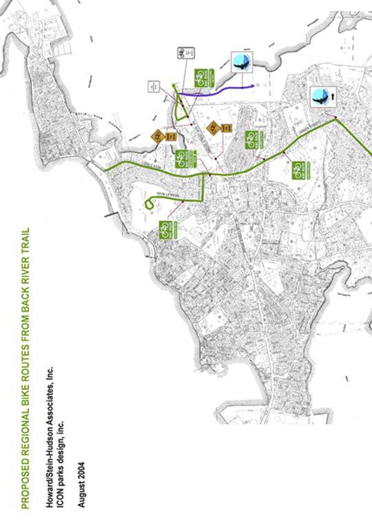
99 16
100 Design Criteria for Trail Alignment Design Speed New off-road segments of the bicycle path should be designed for a minimum design speed of 20 miles per hour. In instances where vertical grades exceed 4 percent, over distances of 300, a design speed of 30 miles per hour is more advisable. Grades/Handicapped Accessibility Most new bicycle trails are designed with the intention of maintaining handicapped accessibility as far as possible. The Back River Trail, which traverses the eskers of Great Esker Park, should not be held to such design restraints, due to environmental, aesthetic and cost considerations that would destroy the landscape and break the bank. This does not reduce the need and desire to have segments of the trail which fit the ideal slope of 5% or less necessary for compliance with the Americans with Disabilities Act, and thus allow handicapped individuals to partake in the joys of this trail. Certainly the Durante property and some of the landfill site can be designed to this standard, and the new access adjacent to Lowe s parking lot will increase accessibility to the more level portions of Great Esker Park. Every effort should be made to make the proposed boardwalk under the Route 3A bridge accessible from Abigail Adams State Park, where views are spectacular and the fishing is excellent. While it is not feasible for the majority of the trail network to be handicap accessible, access points along the trail should provide opportunities for the disabled user to have the widest range of experiences possible. It should be noted that the friction factor for stabilized stone dust is 50% of that for bituminous concrete and thus horizontal curves need to be wider and slopes less steep than on bituminous concrete. Due to greater braking distances and potential side skids, slopes on stabilized stone dust trails intended for use by bikes should be kept to a minimum; long slopes with limited sight distances should be 3% or less. Cross slopes and superelevation rates of horizontal curves shall be limited to 2% to address handicap accessibility issues. The exception to this rule will be in more remote locations where, due to the nature of the terrain or environmental factors, the trails cannot be brought up to accessibility standards. In these locations, superelevation may exceed the 2% to improve the safety of the ride and minimize horizontal curvature. A large portion of the existing trail within Great Esker Park not only exceeds the desired 5% slope required for compliance with the Americans with Disabilities Act, but also exceeds the guidelines set forth by AASHTO for the design of bicycle facilities. New segments proposed should, at a minimum, meet the following grade restrictions and grade lengths set forth by the American Association of State and Highway Transportation Officials (Guide for the Development of Bicycle Facilities): 17
101 AASHTO Grade Restriction/Grade Length % slope Length of run allowed 5-6% for up to 800 7% for up to 400 8% for up to 300 9% for up to % for up to % for up to 50 In order to mitigate the use of steeper grades, it is advisable to widen the path by an additional 4 to 6 to permit slower speed cyclists to dismount and walk their bicycles. The provision of signs that alert the cyclist of steeper grades ahead is an inexpensive and useful tool to be considered. Sight Distance The ability to see ahead is of utmost importance in the safe and efficient operation of a bicycle. Sight distances of sufficient length must be provided so that cyclists can control the operation of their bikes to avoid unexpected collisions. The stopping distance of a bicycle is dependent on the bicyclist s perception and brake reaction time, the initial speed of the bicycle, the coefficient of friction between the tires and the pavement, and the braking ability of the bicycle. Other factors come into play as well, such as the rider s ability and weather conditions, which often lengthen the required sight distances. In general, a cyclist descending at a rate of 20 miles per hour on a slope of 5% requires a 131-foot sight distance. At thirty miles per hour this distance stretches to Stabilized stone dust, with its reduced coefficient of friction (about half that of a bituminous surface), will have a sight distance of for a design speed of 20 mph and 396 at 30 mph on a 5% slope. It should be noted that bicyclists frequently ride abreast of each other and in groups along a trail. On narrow paths, bicyclists tend to ride near the middle of the path. For these reasons, and due to the serious consequences of a head-on bicycle accident, lateral clearances on horizontal curves should be calculated based on the sum of the stopping sight distances for the cyclists traveling in opposite directions around a curve. In some instances, such as at the tight twist near the top of the Great Esker, this will not be possible, yet some improvements should be made to minimize conflicts that will arise as ridership increases. In cases like these, the widening of the path through the curves, the painting of a yellow center stripe, and the installation of curve-ahead warnings are desirable. The use of stabilized stone dust, with its reduced coefficient of friction and the impossibility of painting a centerline stripe, is not advised in areas of high speed and poor sight distance. The following formula shall be used to determine the stopping sight distance: 18
102 S = V V 30 (F + G) Where: S = stopping sight distance (ft) V = velocity (mph) F = coefficient of friction (use 0.25) G = grade (ft/ft) (rise/run) Appendix B: Stopping Sight Distances for Paved Shared Use Paths includes a chart of calculations for both bituminous concrete and stabilized stone dust surfaces. Horizontal Curvature The horizontal curvature of the trails must be designed in a manner consistent with the facilities design speed, superelevation, and friction factor of surfacing material. Though the actual friction factor of stabilized stone dust is not yet widely agreed upon, many engineers believe that a friction factor of one half of that used for bituminous concrete is appropriate. For bituminous concrete, the minimum horizontal curve for a 20 mph facility with 2% superelevation would be about 90. For a stabilized stone dust path, for a 20 mph facility with 2% superelevation, the minimum horizontal curve amounts to 170, or nearly double that of the bituminous path. As the steepness of the grade increases, especially on long runs, once speed increases, the design speed should be increased and the radii enlarged for safety reasons. On non-paved surfaces where lower speeds are attained, a design speed of 15 mph can be used. Appendix C shows minimum radii for paved shared use paths for both bituminous concrete and stabilized stone dust surfaces. As previously noted, there will be locations where rules need to be broken to preserve the integrity of the environment. Where this occurs, additional signage should be utilized to warn users of potential conflicts. Vertical Curvature The design of vertical curves is based upon several factors, including stopping sight distance, slope, and eye height of cyclist. With the exception of stopping distance, the design criteria will be the same for any pavement surface chosen. The proposed trail network includes the use of both bituminous and stone dust surfacing, each of which has significantly different coefficients of friction, and thus different stopping sight distances. As described above, the coefficient of friction of stabilized stone dust can be considered to be half that of bituminous concrete. Appendix E of this document shows desired vertical curves for various conditions on both bituminous concrete and stone dust paths based on stopping sight distance. 19
103 Trail Maintenance A detailed maintenance plan should be developed in conjunction with the construction of the trail network. The plan should outline the type of maintenance required for each section of the network and should establish a schedule for routine maintenance activities. Existing Trail Upgrade The existing bituminous trail through Great Esker Park is a fantastic backyard playground for the surrounding neighborhoods, providing opportunities for hiking, dog walking, cycling and to a lesser degree rollerblading and skateboarding. It currently meets the needs of the limited population that uses it. With the addition of the proposed improvements and connections to Hingham and the Boston Harbor Islands beyond, the user base will swell, increasing the need for improvements along the entire length of the existing trail. With increased ridership comes the need for better sight distances, smoother, wider radii, signage, shoulders and the like. It is not the intention of this plan to bring the older portion completely up to current design standards, which would greatly alter the site, and certainly not to make the trail up and down the eskers handicapped accessible. The changes proposed are reasonable and necessary upgrades that will make the bikeway safer for an increased user base. Trail edge improvements: o Smooth soft shoulders min. width of 2 o Removal of vertical elements within three feet of the trail edges (boulders, trees, signs, etc.) o Cut back bituminous lip and add shoulder flush with path. Replace vehicle style guard rails with bike safe guard rails. Make improvements to sight distance and trail alignment/width at southern descent of the Great Esker. Add dividing line and warning sign. Make drainage improvements on the north sloping face of the Great Esker and, if possible, eliminate the water bars. Patch the pavement where broken or recently disturbed to improve drainage under the trail. Resurface the trail and where necessary provide full depth reconstruction to remove vehicle ruts, bringing the trail up to the appearance of new portions of the trail. Signs and Traffic Markings Signs for both motorists and cyclists should be inspected regularly and kept in good condition. Striping should be kept prominent. The design and locations of signs must be as dictated in the Manual of Uniform Traffic Control Devices. Visibility Illumination Although the trail system is not designed as an illuminated facility, lighting at intersections and along the on-street segments of the trail 20
104 should be maintained and upgraded, if necessary, to avoid dark spots. One of the proposed design options for the on-road connection to the Iron Hill Fish Ladder Park includes a mid-block crossing. The location has been chosen to maximize the site distance for vehicles coming over the hill from the north. If this approach is chosen it is imperative that the light levels at the crossing be increased to highlight the crosswalk and improve the visibility of the cyclists. Lights, once installed, must be maintained to assure reliable operation and be cleaned and relamped, as required, to maintain the desired level of illumination. Sight Distance and Clearance Sight distances on trails should not be allowed to become impaired, especially where the trail leads up to crossings and curves. Trees, shrubs, and tall weeds and grasses should regularly be inspected and either removed or pruned to maintain sight distances. Sight distance requirements vary with speed, and although the trail is proposed to be designed at a 20 mph speed, additional sight distance should be allowed where cyclists are consistently traveling at a higher rate. Adequate clearances on both sides of the trail and overhead clearances must be checked and maintained. Tree branches should be trimmed to allow for seasonal growth without encroaching onto the trail. Surface Repair The inspection of trails for holes and bumps must be completed at least twice a year. On stabilized stone dust surfaces, little or no repair work will be required for the first three to five years, but some major regrading and patching work should be expected within eight to ten years. Much of the work will be caused by roots pushing the pavement up. This will require cutting out sections of the pavement and removing the offending roots prior to patching. Patching and repair of trails must be done carefully to assure that the final patch is flush with the adjacent surfaces. Sufficient compaction must be provided to assure that the patch does not settle. Where trees have caused considerable damage along a segment of trail, the resurfacing of the trail should be considered once patching and crack repair is completed. Damage from roots can be minimized by the use of root barriers. The following page includes an illustration of appropriate path construction where trails are located near shallow rooted trees. Repairs can be made more easily on the stabilized stone dust trail segments than on the bituminous surfaced trails. The material is carefully removed and stockpiled adjacent to the hole being excavated. The roots are removed and base material backfilled and compacted. The stabilized stone dust material is then moistened and compacted back on top. Care should be taken not to mix the subsoil or gravel base with the stone dust to prevent changing the consistency of the material. In severe situations, it may be necessary to add additional stabilized stone dust material, the mixture of which should closely match the existing path in color and gradient size. Appendix E, Stabilized Stone Dust Paving Construction Specifications, provides detailed instructions for both construction and maintenance. Surface repair of bituminous concrete trails should be conducted in the same manner as on roads. 21
105 The stabilized stone dust path can become soft during periods of heavy rain, especially in late spring when snow melts prolong drying times. During this period the trail will be prone to damage by rutting if heavy vehicles cross it. With heavy moisture content, the trail will be most suitable for jogging, due to its greater resilience, but may be scarred by cyclists that brake hard and skid. If rutted or damaged, the trail can easily be repaired by back-blading the surface with a bobcat or other earthwork machine, preferably scaled to the width of the particular trail being repaired. Drainage In some locations where runoff collects and flows along or across the trail the stabilized stone dust trail will encounter erosion problems. Seasonal washouts, silt or gravel washes across the trail, or sinking should be watched for and appropriate measures taken. As described above under Drainage Considerations, where drainage structures are located within the roadways at trail/roadway intersections, maintenance personnel should be instructed to place the grates so that the openings are perpendicular to the trail s direction of travel. 22
106 Sweeping and Cleaning For both stabilized stone dust and bituminous concrete trails, the removal of broken bottles and other sharp objects should be undertaken on an as-needed basis. In the fall, wet leaves may collect on the trails and create slippery conditions. Loose gravel or sticks on an asphalt surface can cause a serious fall. The trail should be policed, preferably by a cyclist who is familiar with trail issues, and hazardous conditions should be corrected as soon as possible. Some problems caused by erosion and windblown debris will tend to be isolated to specific segments or even bends in the trail, while broken bottles and the like may occur anywhere. A system of reporting problems might be considered by which every rider becomes the eyes of the maintenance crew. Maintenance slips could be produced on 3 x 5 cards with a key map on which the observer can pinpoint the location and write a description of the problem. Collection boxes could be placed in several locations along the trail where riders could obtain and deposit the cards. Trash Pick Up Currently, trash receptacles are not proposed along the length of the trail, but several should be provided at destinations such as the kayak launch site, the Iron Hill Fish Ladder Park, Herring Run Pond and gateway areas such as at Lowe s parking lot and at intersecting streets and various other key destinations. In addition, receptacles should be considered at scenic rest areas, as long as they can be maintained and emptied. They should be located where they can easily be picked up from an existing road or driveway without having to traverse the trail itself. Structure Deterioration Bridge structures, guardrails and drainage structures should be inspected for structural damage caused by rot, vandals, or other causes, which will prevent them from performing as intended. Bridges and guardrails should be inspected twice a year. Culverts should be inspected after heavy storms to ensure that they have not become clogged. 23
107 Appendix C Stopping Sight Distances for Paved Shared Use Trails
108 Back River Trail Appendix C Back River Trail Weymouth, MA Stopping Sight Distances for Paved Shared Use Paths Bituminous Concrete S = Stopping Distance (feet) V = Velocity (MPH) f = coefficient of friction G = grade (feet/feet) (fise/run) BITUMINOUS - ASCENDING BITUMINOUS - DESCENDING V f G S V f G S
109 BITUMINOUS - ASCENDING BITUMINOUS - DESCENDING V f G S V f G S Back River Trail Appendix C
110 Back River Trail Appendix C Stopping Sight Distances for Paved Shared Use Paths Stabilized Stonedust S = Stopping Distance (feet) V = Velocity (MPH) f = coefficient of friction G = grade (feet/feet) (fise/run) STONEDUST - ASCENDING STONEDUST - DESCENDING V f G S V f G S
111 STONEDUST - ASCENDING STONEDUST - DESCENDING V f G S V f G S Back River Trail Appendix C
112 Appendix D Minimum Radii for Paved Shared Use Trails
113 Back River Trail Appendix D Back River Trail Weymouth, MA Minimum Radii for Paved Shared Use Paths BITUMINOUS PATH * STONEDUST PATH * min. min. V(speed) e(su-elev) f(coef-frict) Radius V(speed) e(su-elev) f(coef-frict) Radius * based on 15 degree angle of lean
114 Appendix E Minimum Length of Crest Vertical Curves (L) Based on Stopping Distances
115 Back River Trail Appendix E Vertical Curves: The design of vertical curves is based upon several factors including stopping sight distance, slopes and eye height of cyclist. With the exception of stopping distance the design criteria will be the same for any pavement surface chosen. Presently we are proposing the use of both bituminous and stone dust surfacing, each of which has significantly different coefficients of friction, thus different stopping sight distances. Numerous references are available that contain charts for selecting the proper vertical curves for bituminous concrete surfaces, but none appear to be available for the proposed stabilized surfaces. For this reason we have prepared a spread sheet which shows desired vertical curves for various conditions stone dust surface. For comparison purposes we have also provided information on bituminous pavement requirements.
116 Back River Trail Appendix E Minimum Length of Crest Vertical Curves (L) Based on Stopping Distance Slope 1 = Slope in percent left side of curve Slope 2 = Slope in percent right side of curve V-Curve Length = Length of curve in feet A = Algebraic Grade Difference (%) S = Governing Sight Distance (Longest Sight Distance for the two slopes) when S<L L=ASS/900 Bituminous Concrete - Crest Vertical Curve 20 MPH Design Speed V-Curve Slope-1 Slope-2 S Length
117 Back River Trail Appendix E V-Curve Slope-1 Slope-2 S Length Stonedust Path - Crest Vertical Curve 20 MPH Design Speed V-Curve Slope-1 Slope-2 S Length S<L
118 V-Curve Slope-1 Slope-2 S Length Back River Trail Appendix E
119 Appendix F Stabilized Stone Dust Paving Construction Specifications
120 Back River Trail Appendix F Sample Specifications Mass Highway Format Metric STABILIZED STONE DUST PAVING SQUARE METER DESCRIPTION: The work of this section consists of constructing universally accessible crushed stone pavement on a prepared subgrade. SUBMITTALS A. Submit sieve analysis of crushed aggregate screenings to ensure it meets grading requirements. B. Sieve analysis of crushed aggregate screenings shall be approved in writing by the Resident Engineer before any material is delivered to the project site. C. Prepare a sample finished trail section using all specified. Sample section shall be full width of trail, and length equal to 2X width. Sample trail section shall be approved in writing by the Resident Engineer before the project stabilized stone dust trail is constructed. MATERIALS CRUSHED AGGREGATE SCREENINGS: A. Clean, hard, durable particles or fragments of crushed granite or crushed ¼ minus aggregate meeting the following grading requirements: ¼ Minus Aggregate Gradation Sieve Designation Range of % Passing 3/8 100% No No No No No No No
121 Back River Trail Appendix F Sample Specifications Mass Highway Format Metric B. The crushed aggregate screenings shall be free from clay lumps, vegetable matter, and deleterious material. SOIL STABILIZER: Stabilizer, a non-toxic, colorless, odorless, non-staining, concentrated organic powder that binds soil and crushed aggregate screenings together, creating a natural-appearing, firm trail surface. Stabilizer is manufactured and distributed by Stabilizer, Inc., 4832 East Indian School Rd., Phoenix AZ 85018, Tel: , Fax: OR T-NAPS, Total Natural Assess Paving Systems (Road Oyl Resin Modified Emulsion) as manufactured by George L. Throop Company, Pasadena/LosAngeles, CA, Tel: OR Klingstone Klear as manufactured by Klingstone, Inc., 235 Pigeon St., Waynesville, NC Tel: , Fax Due to the nature of the stone dust crushed aggregate screenings proper penetration of the surfacing material can not be obtained by simply surface applications. Aggregate and stabilizer, regardless of manufacturer chosen, must be premixed in a tumbling cement mixer and applied to the compacted grade. The following construction specification has been prepared for the Stabilizer product as manufactured by Stabilizer, Inc. The T-NAPS and Klingstone Klear Product installation may vary slightly and shall be modified as directed by their company s representative and as approved by the Resident Engineer. WEED CONTROL FABRIC: Typar #3401 thermally spunbonded polypropylene, nonwoven, thin geotextile weed control fabric, 4.0 oz/lineal yard weight (American Excelsior Co., 609 South Front Street, Yakima, WA 98901, Tel: ); or CSI Geotextile Fabric, 600 SE Assembly, Suite 100, Vancouver, WA 98661, Tel: , or fx-44, woven polypropylene silt film geotextile (Carrthage Mills, 1821 Summit Road, Cincinnati, Ohio, ): or approved equal. Needle punched material is not acceptable. CONSTRUCTION
122 Back River Trail Appendix F Sample Specifications Mass Highway Format Metric SUBGRADEPREPARATION: Prior to placing crushed aggregate screenings, shape, fill, grade, and compact the subgrade and gravel base (paid for under other items). WEED CONTROL FABRIC: Fabric shall be installed between the compacted gravel base course and crushed aggregate screenings to prevent weeds from growing up through the stone dust trail; pre-emergent chemicals may not be used. Place fabric across the entire width of trail surface to receive aggregate; overlap ends of rolls a minimum of 12 inches. SOIL STABILIZER: A. Thoroughly pre-blend Stabilizer with the crushed aggregate screenings, at the rate of 7 kilograms (kg) of Stabilizer per metric ton of aggregate screenings prior to placing of Stabilized mix. It is essential that Stabilizer be mixed thoroughly and uniformly through the crushed aggregate screenings to achieve a successful result. The Stabilizer locks the fines together, trapping the larger crushed aggregate screenings; Stabilizer does not act directly on larger aggregate screenings. Blending is best accomplished with a truck-mounted mixer. Blend for a minimum of 15 minutes prior to placing on top of weed control fabric. B. Drop spreading of Stabilizer over raked crushed aggregate screenings and mixing Stabilizer by rototilling is not acceptable. C. Soil stabilizer shall not be applied during, just prior to, or immediately following rainfall. PLACING CRUSHED AGGREGATE SCREENINGS: After pre-blending, place the Stabilized crushed aggregate screenings (CAS) on prepared gravel base, and rake smooth using a steel tine rake to desired grade and cross section. Place to avoid segregation, in two layers of 50 millimeters minimum thickness. Do not apply CAS deeper than 75 millimeters in one lift. Final compacted depth to be a
123 Back River Trail Appendix F Sample Specifications Mass Highway Format Metric minimum of 100 millimeters after the second layer is installed. WATERING: Water heavily to achieve full depth moisture penetration of the trail mix. Watering is best accomplished using a garden hose with spray nozzle set to a coarse spray; pressure should not disturb leveled trail surface. A one-hour application at a rate of +80 Liters (L) per 100 square meters of trail mix surface seems to achieve the desired full depth moisture penetration. Water activates Stabilizer; consequently, it is essential that the full depth of Stabilized trail material is saturated. Test for depth of water penetration by random inspection of trail cores. After inspection, fill core holes with material removed, smooth and hand tamp to match adjoining trail surface grade. (Let watered trail mix stand 6-24 hours until surface water is no longer present; the trail mix should then be moist but not wet. COMPACTION: While the trail mix is still thoroughly moist, roll with a heavy lawn roller (minimum 100 kilograms and maximum 0.75 meters width), to achieve finish grade and initial compaction. Hand tamp edges around concrete delineator strips. Use a heavy (1 metric ton minimum) small rider, after having initially used the lawn roller, to obtain the desired final dense, smooth, uniform texture. Do not use wackers or vibratory rollers; the trail mix will not harden for weeks after vibration. FINISHING: After finished compacted trail surface has been achieved, finish adjacent shoulders by backfilling with loam borrow, compacting to match existing undisturbed ground, and slope to required grade and cross section. INSPECTION: A. Finished surface of trail shall be smooth, uniform and solid, with no evidence of chipping or cracking. Dried,
124 Back River Trail Appendix F Sample Specifications Mass Highway Format Metric compacted trail material shall be firm all the way through with no spongy areas. B. Loose gravel on the surface, or unconsolidated crushed aggregate screenings below the surface, is evidence of improper bonding due to poor mixing or insufficient watering. Test the loose material for adequate Stabilizer by wetting, then tamping, and allowing it to dry. If the material still is unconsolidated, Stabilizer did not get mixed adequately throughout the crushed aggregate screenings. If the material now is solid, initial watering was insufficient. Cracking or sponginess is evidence of excessive Stabilizer in the mix. C. Unconsolidated areas shall be dug out, and be replaced with new crushed aggregate screenings with a high proportion of fines meeting the grading requirements and pre-blended with Stabilizer per the procedures listed under as specified above. Patched areas then shall be wetted thoroughly and rolled smooth. Patching shall be completed prior to any trail smoothing required. D. Any significant irregularities shall be smoothed out prior to final acceptance of work. Smoothing shall be accomplished by rewetting/saturating rough areas thoroughly, and then rolling the trail again with a heavy roller ( kilogram powered walk-behind or small rider). Wackers are not acceptable. E. Final thickness of completed trail shall not vary more than 12.5 millimeter from dimension indicated. Measurements may be taken by means of test holes taken at random in finished trail surface. Correct any variations in the thickness beyond the allowable 12.5 millimeter tolerance by repeating the procedures listed under above. F. Final width of completed trail shall not vary more than 50 millimeters from typical dimension indicated. Measurements may be taken at random cross sections in the finished trail surface.
125 Back River Trail Appendix F Sample Specifications Mass Highway Format Metric G. No edges of weed control fabric shall be exposed. MEASUREMENT AND PAYMENT A. Payment under this item shall be the contract unit price per square meter of pavement measured in place. Payment shall be full compensation for materials crushed aggregate screenings, Soil stabilizer, and filter fabric, labor, tools and other incidental costs necessary for the satisfactory completion of the work.. Gravel sub-base shall be paid under item 151. Gravel Borrow.
126 Appendix G Bike Trail Memos
127 M E M O R A N D U M To: John Ryther Date: August 24, 2005 From: Anne McKinnon HSH Project No Subject: Items requiring additional study For your list of items requiring additional study in the final report: 1. Water Street land use, zoning, and urban design. 2. Water/Pleasant Street proposed intersection reconstruction 3. Bikeway crossing at Broad and Commercial streets. 4. Bikeway connection along the water from east end of Abigail Adams Park to Neck Street. 5. With Hingham: Bikeway connection from the east end of Bare Cove Park to Commercial Street or other option. This connection would be farther east than the existing entrance to Bare Cove Park and would reduce the distance cyclists would ride on Commercial Street as they head over to the Back River Trail. HOWARD/STEIN-HUDSON ASSOCIATES, INC. 38 Chauncy Street, 9th Floor Boston, Massachusetts Web / Phone (617) Fax (617) info@hshassoc.com Page 1 C:\DOCUMENTS AND SETTINGS\TROSE\MY DOCUMENTS\WEYCMS200\PLAN\BACKRIVER\ADDITIONAL STUDY ITEMS.DOC
128 M E M O R A N D U M To: John Ryther Date: August 24, 2005 From: Anne McKinnon HSH Project No Subject: Back River Trail funding options DRAFT The Back River Trail could be designed and built using funds from a number of state and federal sources. Examples of funding sources include: TEA-21 Transportation Enhancement Program: This program, part of the 1998 Transportation Efficiency Act for the 21 st Century, authorizes funds for projects that have not traditionally been funded by the Federal Highway Administration. The Back River Trail would be considered a regional project and could qualify for Final Design and Construction funds. As a bicycle and pedestrian project, the Back River Trail would meet all three project eligibility criteria (relates to surface transportation system, non-traditional transportation project, includes a transportation enhancement activity). The new (November 2003) Enhancements Program guidelines require two phases, pre-application and final application, and requires that municipalities to undertake a significant portion of the planning and design before submitting the final application. Evidence of the town s ability to provide the required 10 percent project match is needed. Finally, the application must document the community participation process and community support for the project. The detailed nature of the two-phase application process has the effect of reducing the number of applications received by MAPC; only about three applications for funding per quarter are submitted. A strong project would have a decent chance of being funded. Public Works Economic Development grant: Administered by the Executive Office of Transportation and Construction, the PWED program is funded through the Transportation Bond Bill authorization. The current version of this Bond Bill includes $25 million for the PWED program. Eligible projects include those associated with a municipal economic development effort that seeks to have a positive impact on the local tax base leverage high-ratio private investment, and strengthen partnerships between the public and private sectors. In the past PWED funds were heavily used for roadway construction of improvements to serve new development such as industrial parks. A growing use of PWED funds, however, is to support smaller types of infrastructure improvements, such as those in downtown districts. The on-street portions of the Back River Trail in Jackson Square could be done as part of a downtown project to help strengthen the existing businesses through pedestrian/bicycle improvements, streetscape HOWARD/STEIN-HUDSON ASSOCIATES, INC. 38 Chauncy Street, 9th Floor Boston, Massachusetts Web / Phone (617) Fax (617) info@hshassoc.com Page 1 C:\DOCUMENTS AND SETTINGS\TROSE\MY DOCUMENTS\WEYCMS200\PLAN\BACKRIVER\FUNDING MEMO 0722.DOC
129 Howard/Stein-Hudson Associates enhancements, and improvements to on- and off-street parking. Urban Self-Help grants: Administered by the Executive Office of Environmental Affairs, Urban Self-Help grants provide funding for construction, restoration, and rehabilitation of land for park and outdoor recreation purposes for municipalities with over 35,000 inhabitants. The program is a reimbursement program offering 30 percent to 50 percent reimbursement. The Executive Office of Environmental Affairs is offering a Grants Workshop at 10:00 a.m. on Thursday, August 12, Environmental Bond Bill: The 2002 Environmental Bond Bill provides $707 million for environmental programs, including $500,000 for the creation and maintenance of a linked trail system for local and state parks along the Back River in the towns of Weymouth and Hingham. The three-year authorization will end in Inclusion of this in the Environmental Bond Bill, despite the state s inaction, can be very useful in leveraging other funds. State elected officials should be encouraged to continue their efforts to secure funding now that the Town has advanced the project through this planning effort. Livable Communities Initiative: The Federal Transit Administration s Livable Communities Initiative could be explored to help fund access improvements to the commuter rail station at East Weymouth, the ferry terminal in Hingham, and to fund bicycle and pedestrian improvements to and through the two parking lots. The emphasis of this program is on transit enhancement, and the Back River Trail s connection with two transit facilities could make it an attractive project. Public-Private Partnerships: Private-sector participation could include additional contributions from the Harborlight Mall developers and owners, Jackson Square developers including Dunkin Donuts, and assistance from potential developers on Iron Hill Street if some of the town-owned parcel is made available for development. Page 2

130 M E M O R A N D U M To: John Ryther Date: August 24, 2005 From: Anne McKinnon HSH Project No Subject: Weymouth regional bicycle connections Principles: 1. The Back River Trail system is being conceived as a system for cyclists of all ages and abilities. 2. The Back River Trail is being conceived as the spine for bicycle travel throughout Weymouth that will simplify bicycle access to attractions such as Great Hill Park, the beach, and Bare Cove Park, Stodder s Neck, and ferry service to the Boston Harbor Islands. 3. Concepts for on-street routing seek to minimize mid-block crossings, left turns, and narrow streets with heavy traffic. 4. Bicycle facilities must provide for two-way travel, either on a separate trail or bike lanes on both sides of a two-way street. Two-way bike lanes are unacceptable. 5. Bicycle facilities (lanes and paths) that take cyclists out of their way are not used to their fullest and should be avoided. 6. Local-area maps produced by the Town that display the routes and trails will help explain and promote these regional connections. A. South regional bicycle routes accessing the Back River Trail Middle Street and Pleasant Street north of Washington Street could be restriped to add bicycle lanes. Include bike route signage with the destination Jackson Square and the Back River Trail logo. Lake Street around Whitman s Pond is not wide enough for marked bike lanes. Use Share the Road signs to aid cyclists to the Back River Trail and Jackson Square. B. Back River Trail Jackson Square Alternatives: Water Street Route This alternative uses Water Street in both directions and is the most direct route to Rennie Park and Iron Hill Park. Bike lanes on Water Street and signage would direct cyclists to the fish ladder, Jackson Square attractions, and the off-road trail beginning at Rennie Park. Two options are shown for crossing the intersection of Commercial Street/Broad HOWARD/STEIN-HUDSON ASSOCIATES, INC. 38 Chauncy Street, 9th Floor Boston, Massachusetts Web / Phone (617) Fax (617) info@hshassoc.com Page 1 C:\DOCUMENTS AND SETTINGS\TROSE\MY DOCUMENTS\WEYCMS200\PLAN\BACKRIVER\ON-ROAD ROUTE MEMO 0825.DOC
FEASIBILITY CRITERIA
 This chapter describes the methodology and criteria used to evaluate the feasibility of developing trails throughout the study areas. Land availability, habitat sensitivity, roadway crossings and on-street
Appendix 3. Greenway Design Standards. The Whitemarsh Township Greenway Plan
 Appendix 3 Greenway Design Standards This chapter discusses two design standards for the greenway types discussed above. First, trail design standards are presented together with trailhead facilities and
THAT the Board approve the final proposed concept plan for the Jericho Marginal Wharf site as shown in Figure C-4 of Appendix C.
 Date: January 17, 2012 TO: Board Members Vancouver Park Board FROM: General Manager Parks and Recreation SUBJECT: Jericho Marginal Wharf Phase 2 Concept Plan RECOMMENDATION THAT the Board approve the final
Blueways: Rivers, lakes, or streams with public access for recreation that includes fishing, nature observation, and opportunities for boating.
 Parks, Open Space and Trails PRINCE WILLIAM COUNTY 2008 COMPREHENSIVE PLAN TRAILS PLAN CONTENTS The components of the trails plan are: Intent Definitions Goals, Policies, and Action Strategies Trails Map
Longmont to Boulder Regional Trail Jay Road Connection DRAFT FINAL REPORT
 Longmont to Boulder Regional Trail Jay Road Connection DRAFT FINAL REPORT December 2018 Project Summary Boulder County, Colorado, in partnership with the City of Boulder, is evaluating options for multi-use
City of Durango 5.8 FUNDING TRAILS DEVELOPMENT
 5.8 FUNDING TRAILS DEVELOPMENT The City has been successful in establishing dedicated local funding sources as well as applying for grants to develop the City s trail system, having received nearly $2.4
Chapter 6: POLICY AND PROCEDURE RECOMMENDATIONS
 Chapter 6 POLICY AND PROCEDURE RECOMMENDATIONS FOR SRRA Below are seven policy elements that should be considered for adoption by the Southwest Regional Recreation Authority of Virginia: 1. Develop strategies
Lake Myra County Park. Wake County, North Carolina Community Forum #2 June 12, 2008
 Lake Myra County Park Wake County, North Carolina Community Forum #2 June 12, 2008 Welcome and Introduction Meeting Agenda Welcome Introductions of Project Team Master Plan Process Community Forum #1 Updates
Proposal to Redevelop Lower Kananaskis River-Barrier Lake. Bow Valley Provincial Park. Frequently Asked Questions
 Proposal to Redevelop Lower Kananaskis River-Barrier Lake Bow Valley Provincial Park Frequently Asked Questions What is being proposed? What are the details of the proposal? Where is the project area located?
Citrus Heights Creek Corridor Trail Project Trail Advisory Group Field Trip #2 September 11, :00 11:00 am Trellis Hall, Citrus Heights
 September 11, 2013 9:00 11:00 am Trellis Hall, Citrus Heights Project Overview The City of Citrus Heights is studying the feasibility of establishing a multi use trail system within the City s 26 miles
2. Goals and Policies. The following are the adopted Parks and Trails Goals for Stillwater Township:
 D. PARKS AND TRAILS 1. Introduction Stillwater Township s population is relatively low, with most residents living on rural residences on large lots. The need for active park space has been minimal in
MORGAN CREEK GREENWAY Final Report APPENDICES
 APPENDICES MORGAN CREEK GREENWAY Appendix A Photos of Existing Conditions in Trail Corridor Photos of existing conditions Main trail corridor - February 2009 Photos of existing conditions south bank Morgan
3. COLTA / HUGA CONNECTIONS - PRELIMINARY
 9 3. COLTA / HUGA CONNECTIONS - PRELIMINARY 3.1 COLTA The Chain of Lakes Trail Association (COLTA) trail, formerly identified as the Chester Spur Line, was completed and opened for use in June 2011. The
Silver Lake Park An Environmental Jewel for the Citizens of Prince William County
 Silver Lake Park An Environmental Jewel for the Citizens of Prince William County The Prince William Park Authority Mission Statement states: The Prince William County Park Authority will create quality
Welcome to the future of Terwillegar Park a Unique Natural Park
 Welcome to the future of Terwillegar Park a Unique Natural Park 1 Introduction The Terwillegar Park Concept Plan study will develop an overall concept plan, management objectives and development guidelines
United States Department of the Interior National Park Service. Boundary Expansion Listed in National Register January 11, 2017
 NPS Form 10900-a (Rev. 8/2002) OMB No. 10240018 United States Department of the Interior National Park Service Boundary Expansion Listed in National Register January 11, 2017 National Register of Historic
National Recreation Trail Application for Designation
 National Recreation Trail Application for Designation Introduction Thank you for your interest in the National Recreation Trail (NRT) program. Completed NRT application packages must be submitted by December
Flow Stand Up Paddle Board Parkway Plan Analysis
 Regional Parks Department Jeffrey R. Leatherman, Director County of Sacramento Divisions Administration Golf Leisure Services Maintenance Rangers Therapeutic Recreation Services Flow Stand Up Paddle Board
2016 Regional Transportation Alternatives Program (TAP) Grant Application
 Grant Application") 2016 Regional Transportation Alternatives Program (TAP) Grant Application PROJECT TITLE: Yelm-Tenino Trail Extension Feasibility Study TRPC use only GENERAL PROJECT INFORMATION Agency or Organization City
2016 Regional Transportation Alternatives Program (TAP) Grant Application PROJECT TITLE: Yelm-Tenino Trail Extension Feasibility Study TRPC use only GENERAL PROJECT INFORMATION Agency or Organization City
chapter - Hex Highway Touring Route Hamburg to Strausstown Overview
 chapter - 2 Hex Highway Touring Route Hamburg to Strausstown Overview The on-road Hex Highway automobile and bicycle touring route begins on State Street in downtown Hamburg. The route continues west on
City of Haslett. City of East Lansing. City of East Lansing
 Central Park North (Nancy L. Moore Park) Lake Park North Expansion White Park Expansion #2 White Park Expansion #1 County East East Haslett East East TF87-212 Acquisition $90,000.00 Park. TF08-138 Acquisition
Understanding user expectations And planning for long term sustainability 1
 Understanding user expectations And planning for long term sustainability 1 What is a natural surface trail? It can be as simple has a mineral soil, mulched or graveled pathway, or as developed as elevated
Pinellas County Environmental Lands
 Pinellas County Environmental Lands In addition to traditional parks and recreation facilities, Pinellas County owns and manages a system of environmental lands that provides specialized resource-based
Welcome to the Cross County Trail Public Input Session!
 Welcome to the Cross County Trail Public Input Session! Please sign in on the table below! What are we doing here? Camden County has proposed a bicycle and pedestrian trail spanning across the entire county.
Georgetown-Lewes Rail/Trail Study. Rail/Trail Study: Cool Spring to Cape Henlopen State Park New Road Extension (House Resolution No.
 Georgetown-Lewes Rail/Trail Study Rail/Trail Study: Cool Spring to Cape Henlopen State Park New Road Extension (House Resolution No. 47) August 22, 2011 Presentation Outline Background Benefits Statewide
AGENDA ITEM 5 D WAKULLA ENVIRONMENTAL INSTITUTE (WEI) TRAIL FEASIBILITY STUDY
 TRAIL FEASIBILITY STUDY") March 19, 2018 AGENDA ITEM 5 D WAKULLA ENVIRONMENTAL INSTITUTE (WEI) TRAIL FEASIBILITY STUDY TYPE OF ITEM: Action STATEMENT OF ISSUE The Wakulla Environmental Institute (WEI) Trail is one of several trails
March 19, 2018 AGENDA ITEM 5 D WAKULLA ENVIRONMENTAL INSTITUTE (WEI) TRAIL FEASIBILITY STUDY TYPE OF ITEM: Action STATEMENT OF ISSUE The Wakulla Environmental Institute (WEI) Trail is one of several trails
Dungeness Recreation Area County Park Master Plan
 Dungeness Recreation Area County Park Public Outreach Meeting October 10, 2007 Project Overview USFWS Site Dungeness Recreation Area County Park Meeting Objectives: Re-Introduce project; provide status
NEWBORO AND PORTLAND HARBOUR REDVELOPMENT PLANS
 INTRODUCTION The Municipal docks in both Newboro and Portland were transferred to the Township of Rideau Lakes by Parks Canada in 2002. Little has been done to improve the docks physical condition or role
Port Gamble Shoreline Area Conceptual Trail Proposal
 The North Kitsap Trails Association is pleased to be a partner to the Kitsap Forest and Bay Project and assist Kitsap County, Forterra, Olympic Property Group, Great Peninsula Conservancy and the Port
Proposal to Redevelop Lower Kananaskis River-Barrier Lake. Bow Valley Provincial Park
 Frequently Asked Questions Proposal to Redevelop Lower Kananaskis River-Barrier Lake Bow Valley Provincial Park Frequently Asked Questions What has been decided? What are the details of the plan? What
The Vision for the San Juan Islands Scenic Byway
 The Vision for the San Juan Islands Scenic Byway 2 Judd Cove, Orcas Island, Courtesy of Kurt Thorson (kurtthorson.com) and San Juan County Land Bank Vision for the San Juan Islands Scenic Byway The San
National Recreation Trail Update Form
 National Recreation Trail Update Form Introduction Thank you for taking the time to complete this form. Your assistance will help ensure that the National Recreation Trail (NRT) database is complete and
Preferred Recreation Recommendations Stemilt-Squilchuck Recreation Plan March 2018
 Preferred Recreation Recommendations Stemilt-Squilchuck Recreation Plan March 2018 Below are the recommended recreation ideas and strategies that package together the various recreation concepts compiled
Auburn Trail / Ontario Pathways Trail Connector Feasibility Study Public Information Meeting Wednesday, August 22, 2012
 Auburn Trail / Ontario Pathways Trail Connector Feasibility Study Public Information Meeting Wednesday, August 22, 2012 Purpose of Feasibility Study Purpose Evaluate the feasibility of constructing a multiuse
Lake Wissota Access Locations within the LaFayette Township. By Chad Martin
 Lake Wissota Access Locations within the LaFayette Township By Chad Martin Anson/ Wissota Access Point # 1 Road: 195 th St. Associated Fire Numbers: 13294 Defining Characteristics: Forested from road
MPRB: Southwest LRT Community Advisory Committee Issues and Outcomes by Location Current to: 12 November 2010
 MPRB: Southwest LRT Community Advisory Committee Issues and Outcomes by Location Current to: 12 November 2010 This is a compilation of issues and outcomes identified by the CAC. It is a work in progress,
Jefferson County Non-Motorized Transportation and Recreational Trails Plan 2010
 Chapter 8: Goals and objectives Plan Update: The following update presents general principles, goals, and objectives related to non-motorized transportation facilities as a component of the overall transportation
DATE: 23 March, 2011 TO: Communities FROM: BlazeSports America. RE: Accessible Trails Checklist 1
 M E M O R A N D U M DATE: 23 March, 2011 TO: Communities FROM: BlazeSports America RE: Accessible Trails Checklist 1 The purpose of the Accessible Trails Checklist (below) is to help the community review
MONTGOMERY COUNTY PLANNING DEPARTMENT THE MARYLAND-NATIONAL CAPITAL PARK AND PLANNING COMMISSION
 MONTGOMERY COUNTY PLANNING DEPARTMENT THE MARYLAND-NATIONAL CAPITAL PARK AND PLANNING COMMISSION MCPB Item No. Date: 6/23/2016 Lucy V. Barnsley Elementary School Addition, Mandatory Referral MR2016027
Mt. Hood National Forest
 United States Department of Agriculture Forest Service Mt. Hood National Forest Zigzag Ranger District 70220 E. Highway 26 Zigzag, OR 97049 503-622-3191 Fax: 503-622-5622 File Code: 1950-1 Date: June 29,
The Baker/Carver Regional Trail is intended to
 Section V Design Guidance The Baker/Carver Regional Trail is intended to safely accommodate 183,000 annual visits, an array of non-motorized uses, a variety of skill levels, and persons with special needs.
JOSLIN FIELD, MAGIC VALLEY REGIONAL AIRPORT DECEMBER 2012
 1. Introduction The Federal Aviation Administration (FAA) recommends that airport master plans be updated every 5 years or as necessary to keep them current. The Master Plan for Joslin Field, Magic Valley
River Parks Trail: Tulsa, Oklahoma
 River Parks Trail: Tulsa, Oklahoma Purpose: The purpose of the River Parks Trail is to maintain, preserve, develop, and promote the Arkansas River for the economic and cultural benefit of the community.
Blue River Trail Master Plan JSA to Town Hall June 2004
 Blue River Trail Master Plan JSA to Town Hall June 2004 Prepared for: Silverthorne Town Council Silverthorne SPORT Committee Department of Recreation and Culture Silverthorne Public Works Silverthorne
NORTH HEMPSTEAD BEACH PARK MASTER PLAN
 NORTH HEMPSTEAD BEACH PARK MASTER PLAN COMMUNITY DESIGN CHARRETTE Supervisor Judi Bosworth Viviana L. Russell Peter J. Zuckerman Angelo P. Ferrara Anna M. Kaplan Lee R. Seeman Dina M. De Giorgio VISIONING
Wilds. Headwaters. Lakes. Oxbows. Falls
 56 5 4 3 Wilds Headwaters Lakes Oxbows Falls 57 Zones It could be said the on-the-ground essence of this master plan appears within the next 6 pages of this report. As we learned in the preceding Cultural
Segment 2: La Crescent to Miller s Corner
 goal of the USFWS refuges is to conserve, protect and enhance fish, wildlife and plants and their habitats for the continuing benefit of the American people. Refuge lands are used largely for fishing,
A CASE FOR COMPLETING THE JORDAN RIVER PARKWAY: A
 A CASE FOR COMPLETING THE JORDAN RIVER PARKWAY: A safe crossing at 9000 South and 850 West Proposed 9000 South Underpass Parkway Timeline Parkway, Trail, and Tourism Facts Blueprint Jordan River 1971 1973
Business Item No
 Metropolitan Parks and Open Space Commission Meeting date: February 6, 2018 For the Community Development Committee meeting of February 20, 2018 For the Metropolitan Council meeting of February 28, 2018
how it started where we are now what is coming up NEW WESTMINSTER WATERFRONT PARK THE RIVER THE PAST THE PEOPLE
 how it started Downtown Waterfront Park How It Started March 2009 City of New Westminster Purchases 3.2 Hectare Westminster Pier Site March 2009 City of New Westminster and Design Team develop plan for
EXECUTIVE SUMMARY PROGRAM DEVELOPMENT REPORT PURPOSE EXISTING SETTING EXPANDING PARKLAND
 EXECUTIVE SUMMARY PROGRAM DEVELOPMENT REPORT PURPOSE As the culmination of the first phase of the master planning process, this Program Development Report creates the framework to develop the Calero County
CHAPTER III: TRAIL DESIGN STANDARDS, SPECIFICATIONS & PERMITS
 CHAPTER III Trail Design Standards, Specifications & Permits This chapter discusses trail standards, preferred surface types for different activities, permits, and other requirements one must consider
Cultural Resource Management Report Deer Valley 4wd Restoration and Blue Lakes Road Maintenance Project R
 Cultural Resource Management Report R2015-05-03-10005 Undertaking Description: The proposes to perform road maintenance and meadow restoration on the Deer Valley 4wd trail and road maintenance on the Blue
Procedure for the Use of Power-Driven Mobility Devices on Mass Audubon Sanctuaries 1 September 17, 2012
 Procedure for the Use of Power-Driven Mobility Devices on Mass Audubon Sanctuaries 1 September 17, 2012 Background As part of Mass Audubon s mission to preserve the nature of Massachusetts for people and
Header i
 Header i 048285014.10 Header Sub Title Body Text here. Body text here. Body text here. Section 1... 1 Executive Summary... 1 Opportunities and Constraints... 3 Overall Opportunities and Constraints Map
4.0 Context for the Crossing Project
 4.0 Context for the Crossing Project This section provides background information about key features of the North Douglas Crossing project area, and opportunities and constraints. This information is important
WATER PETALUMA TRAIL WATER WAYS PROJECT PORTFOLIO. petalumawaterways.org OVERVIEW
 WATER TRAIL PROJECT PORTFOLIO OVERVIEW Thirteen miles upstream of San Pablo Bay, Petaluma is the northern point on the San Francisco Bay Water Trail, a network of access points throughout the region. Most
PURPOSE AND NEED. Introduction
 Public Scoping: Allocation of Recreation Capacity for Commercial Outfitter Guide Services on North Kruzof Island Trails (Kruzof Island Outfitter Guide) PURPOSE AND NEED Introduction The U.S. Department
MASTER PLAN EXECUTIVE SUMMARY
 Biscuit Run State Park Scottsville Road (State Route 20) Charlottesville, VA 22902 Biscuit Run State Park MASTER PLAN EXECUTIVE SUMMARY Department of Conservation and Recreation Division of Planning and
Executive Summary. MASTER PLAN UPDATE Fort Collins-Loveland Municipal Airport
 Executive Summary MASTER PLAN UPDATE Fort Collins-Loveland Municipal Airport As a general aviation and commercial service airport, Fort Collins- Loveland Municipal Airport serves as an important niche
Lafourche Parish Government REQUEST FOR QUALIFICATIONS. Landscape Architectural Services
 Lafourche Parish Government REQUEST FOR QUALIFICATIONS Landscape Architectural Services Bayou Lafourche Parish Multi-Use Path Feasibility Study Phase 1 And Bayou Lafourche Parish Multi-Use Path Feasibility
Waukee Trailhead Public Art and Amenities Project
 Waukee - Trailhead Public Art and Amenities Project Sponsor Waukee Project Title Waukee Trailhead Public Art and Amenities Project Termini Description ( i.e. Park Avenue to 19th Street) NE Intersection
DRAFT - APRIL 13, 2007 ROUTING STUDY FOR TRAIL CONNECTIONS BETWEEN CALAIS AND AYERS JUNCTION
 DRAFT - APRIL 13, 2007 ROUTING STUDY FOR TRAIL CONNECTIONS BETWEEN CALAIS AND AYERS JUNCTION Abstract The vision for the East Coast Greenway is an off-road urban trail system running from Calais, Maine
Non-Motorized Transportation
 Non-Motorized Transportation Non-motorized facilities are important components to the transportation system. They provide an environmentally-friendly, low-cost mode of travel. Some of the facilities can
SOUTH INTERCHANGE AREA
 Santaquin City General Plan 1 Location and Characteristics The South Interchange Area of Santaquin is located west of Interstate 15 and south of 500 South (Figure 1). It includes properties already annexed
CRANE LAKE TRAILS NETWORK AND SPACES
 CRANE LAKE TRAILS NETWORK AND SPACES AREA TRAILS COMMUNITY TRAILS GOLD COAST TRAIL LAKE PARK OPTION ONE LAKE PARK OPTION TWO OVERFLOW TRAILHEAD PARKING THE GATE AREA TRAILS Trails are a major resource
ROBERTS CREEK PROVINCIAL PARK MASTER PLAN. November, 1981
 Ministry of Lands, Parks and Housing Parks and Outdoor Recreation Division Park Operations Branch North Vancouver, B. C. ROBERTS CREEK PROVINCIAL PARK MASTER PLAN November, 1981 Mr. G. Trachuk Director
China Creek North Park Upgrades and Glen Pump Station. Park Board Committee Meeting Monday, July 10, 2017
 China Creek North Park Upgrades and Glen Pump Station Park Board Committee Meeting Monday, July 10, 2017 Purpose The purpose of this presentation is to: Share the results of the public engagement processes;
MIDDLE SCHOOL CURRICULUM TR AILING ICE AGE M YST ERI E S ICE AGE TREKKING
 MIDDLE SCHOOL CURRICULUM TR AILING ICE AGE M YST ERI E S ICE AGE TREKKING CONTENTS I. Enduring Knowledge... 3 II. Teacher Background... 3 III. Before Viewing this Video... 5 IV. Viewing Guide... 5 V. Discussion
Chapter 6. Trail Design. Trail Design
 Chapter 6 Trail Design Trail Design The trail winds through a region rich in scenic beauty, cultural, and natural history. Volunteer landscape architects working with the Core and Planning Teams, have
Stephens Rd. Nature Preserve
 Stephens Rd. Nature Preserve History Stephens Road Nature Preserve (SRNP) is a 350-acre nature preserve in Huntersville that comprises nine properties purchased between 1994 and 2008. Parcels included
Watchorn Provincial Park. Management Plan
 Watchorn Provincial Park Management Plan 2 Watchorn Provincial Park Table of Contents 1. Introduction... 3 2. Park History... 3 3. Park Attributes... 3 3.1 Natural... 4 3.2 Recreational... 4 3.3 Additional
MARBLE RIVER PROVINCIAL PARK
 MARBLE RIVER PROVINCIAL PARK PURPOSE STATEMENT AND ZONING PLAN March 2003 MARBLE RIVER PROVINCIAL PARK Purpose Statement and Zoning Plan Primary Role The primary role of Marble River Park is to protect
Rogue River Access and Management Plan Draft Alternatives
 Rogue River Access and Management Plan Draft Alternatives The Rogue River Access and Management Plan was initiated in December, 2011 and is being led by Jackson County Parks (JCP) and Oregon Department
WELCOME to the Iditarod Dog Sledding Historic District (IDSHD) Workshop. January 11, Houston Middle School Houston, Alaska
 Workshop. January 11, Houston Middle School Houston, Alaska") WELCOME to the Iditarod Dog Sledding Historic District (IDSHD) Workshop January 11, 2012 Houston Middle School Houston, Alaska Workshop Purpose: Present/discuss proposed resolutions to comments received
WELCOME to the Iditarod Dog Sledding Historic District (IDSHD) Workshop January 11, 2012 Houston Middle School Houston, Alaska Workshop Purpose: Present/discuss proposed resolutions to comments received
Cat Island Chain Background & Access Guide
 Cat Chain Background & Access Guide Brown County Port & Resource Recovery Department 2561 S. Broadway, Green Bay, WI 54304 (920) 492-4950 www.portofgreenbay.com January 2018 1 Restoration of the Cat Chain
Hudson Highlands Fjord Trail Draft Master Plan. April 29, 2015
 Hudson Highlands Fjord Trail Draft Master Plan April 29, 2015 Agenda Route Overview Proposed Segment Results of Community Survey on that Segment Next Steps Municipal Endorsement Environmental Review Implementation
THOMAS A. SWIFT METROPARK Introductions History Present Conditions Future Development Plans Implementation Strategies Statistics
 THOMAS A. SWIFT METROPARK Introductions History Present Conditions Future Development Plans Implementation Strategies Statistics Introduction As an open meadow park positioned along the Mahoning River,
Rule Governing the Designation and Establishment of All-Terrain Vehicle Use Trails on State Land
 Rule Governing the Designation and Establishment of All-Terrain Vehicle Use Trails on State Land 1.0 Authority 1.1 This rule is promulgated pursuant to 23 V.S.A. 3506. Section 3506 (b)(4) states that an
Northeast Quadrant Distinctive Features
 NORTHEAST QUADRANT Northeast Quadrant Distinctive Features LAND USE The Northeast Quadrant includes all the area within the planning area that is east of Interstate 5 and to the north of State Route 44.
Community Development
 Community Development City & Borough of Juneau Community Development 155 S. Seward Street Juneau, AK 99801 (907) 586 0715 Phone (907) 586 4529 Fax DATE: February 11, 2016 TO: FROM: Planning Commission
Assessing Your Trails, Keeping Them Safe and Enjoyable
 Jon Wood, PLA, ASLA Associate Vice President Stewart Bert Lynn, PLA, ASLA, LEED AP Project Manager Mecklenburg County Asset and Facility Management Assessing Your Trails, Keeping Them Safe and Enjoyable
CONTENTS. 1 Introduction Always Moving Forward while Building on the Past A Dynamic Destination... 5
 2010 STRUCTURE PLAN - 2 - CONTENTS 1 Introduction... 5 1.1 Always Moving Forward while Building on the Past... 5 1.2 A Dynamic Destination... 5 2 Map A... 6 Exhibition Place and its Neighbours... 7 3 Demonstration
Coronado National Forest Santa Catalina Ranger District
 United States Department of Agriculture Forest Service Coronado National Forest Santa Catalina Ranger District File Code: 1950 Date: October 14, 2015 Dear Interested Party: The Santa Catalina Ranger District
TOURISM & PUBLIC SERVICES RURAL SIGNAGE POLICY
 Policy and Procedures Subject Title: Tourism and Public Services Rural Signage Policy Corporate Policy (Approved by Council): X Policy Ref. No.: ROADS-01-07 Administrative Policy (Approved by CAO): By-Law
Table of Contents. Location... 1 Cultural Heritage Value... 3 Site History... 4 Physical Description... 6 Conclusion... 7 Sources...
 Executive Summary The Outdoor Firing Range, located west of the Small Arms Building at 1300 Lakeshore Road East, merits designation under the Ontario Heritage Act for its historical, architectural and
Camping (Primitive) Camping (RV) Electrical Potable Water Grill Established Fire Pit Picnic Table
 Camping (RV) Electrical Potable Water Grill Established Fire Pit Picnic Table") Alden - 9th Road River Mile 777 Map: 38.20833, -98.32031 Managing Agency: Kansas Department of Wildlife, Parks & Tourism Nearest Community: Alden, Rice County Kansas Developed Amenities Provided Parking
Alden - 9th Road River Mile 777 Map: 38.20833, -98.32031 Managing Agency: Kansas Department of Wildlife, Parks & Tourism Nearest Community: Alden, Rice County Kansas Developed Amenities Provided Parking
ETOBICOKE CREEK NORTH TRAIL PROJECT. May 18, 2017 at Michael Power High School 105 Eringate Drive, Etobicoke ON M9C 3Z7
 ETOBICOKE CREEK NORTH TRAIL PROJECT May 18, 2017 at Michael Power High School 105 Eringate Drive, Etobicoke ON M9C 3Z7 1 Purpose of Open House The purpose of today s open house is to present the design
Becker County Trail Routing Feasibility Study
 2016 Becker County Trail Routing Feasibility Study CONNECTING DETROIT MOUNTAIN AND MOUNTAIN VIEW RECREATIONAL AREA TO THE HEARTLAND TRAIL BECKER COUNTY ULTEIG ENGINEERS Contents Acknowledgements...2 INTRODUCTION...3
2. STAKEHOLDER FEEDBACK // What We Heard
 1. QUARRY ROAD TRAIL // Welcome to the Information Session PROJECT DESCRIPTION WHY WE ARE HERE Quarry Road Trail is a popular commuter trail and recreational area for Calgarians. 1. To report citizen feedback
Ouimet Canyon Provincial Nature Reserve. Management Plan
 Ouimet Canyon Provincial Nature Reserve Management Plan NOTE: This document has been scanned and formatted, and therefore is slightly different from the original version. -March 2002 Additional copies
Redesigning The Waterfront
 San Francisco Maritime National Park Service U.S. Department of the Interior National Historical Park California Redesigning The Waterfront A Self-Guided Walking Tour Then & Black Point Cove, ca. 1910.
Public Notice ISSUED: December 10, 2018 EXPIRES: January 9, 2019
 APPLICANT: REFER TO: St. Louis and Lake Counties Regional Rail Authority 2018-01942-ARC Public Notice ISSUED: December 10, 2018 EXPIRES: January 9, 2019 SECTION:404 - Clean Water Act 1. APPLICATION FOR
Land Management Summary
 photo credit: ANGAIR Anglesea Heath Land Management Summary The Anglesea Heath (6,501 ha) was incorporated into the Great Otway National Park in January 2018. This provides an opportunity to consider the
Logo Department Name Agency Organization Organization Address Information 5700 North Sabino Canyon Road
 Logo Department Name Agency Organization Organization Address Information United States Forest Coronado National Forest 5700 North Sabino Canyon Road Department of Service Santa Catalina Ranger District
Lincoln Woodstock. Riverfront Park and Trail System. Project Description
 Lincoln Woodstock Riverfront Park and Trail System Project Description Rev: 6 Dated: May 16, 2008 Table of Contents I. Executive Summary Page 3 II. The Riverfront Park Page 4 III. The Trail System Page
WASHINGTON STATE PARKS AND RECREATION COMMISSION POLICY/PROCEDURE
 WASHINGTON STATE PARKS AND RECREATION COMMISSION POLICY/PROCEDURE 65-13-1 Use of Other Power-Driven Mobility Devices by Persons with Mobility Disabilities at State Park Facilities See Also: 28 CFR 35 Title
National Forests and Grasslands in Texas
 United States Department of Agriculture Forest Service National Forests and Grasslands in Texas Sam Houston NF 394 FM 1375 West New Waverly, Texas 77358 Phone 936-344-6205 Dear Friends, File Code: 1950
CHAPTER 4 -- THE LAND USE PLAN: DESCRIPTIONS AND POLICIES FOR THIRTEEN PLANNING AREAS
 CHAPTER 4 -- THE LAND USE PLAN: DESCRIPTIONS AND POLICIES FOR THIRTEEN PLANNING AREAS NORTH CENTRAL CAC AREA LITTLE VALLEY ROAD TO JUG HANDLE CREEK PLANNING AREA This planning area includes Cleone, Noyo,
Lawrence Loop SWOT Analysis
 Alignment: D1 (Map Color: Dark Blue) Description: This alignment connects to the north end of the Burroughs Creek Trail and continues along the west side of the Railroad to 8 th Street. Strengths: - This