Gallery Guide. Losing a Legacy: A photographic story of disappearing glaciers. Dan Fagre & Lisa McKeon, USGS. Shepard Glacier
|
|
|
- Antonia Cobb
- 6 years ago
- Views:
Transcription


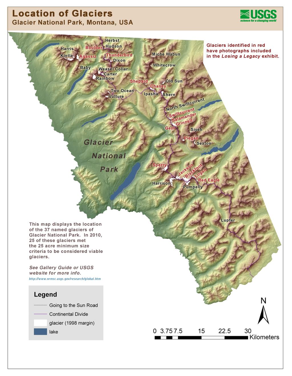
1 Gallery Guide Losing a Legacy: A photographic story of disappearing glaciers Shepard Glacier W.C. Alden photo, GNP Archives B. Reardon photo, USGS Dan Fagre & Lisa McKeon, USGS


2 This gallery guide is provided to help you, the visitor, further interpret and appreciate this collection of photographs. We hope this guide will enhance your visit. Additional information is available at the web link located at the end of the guide. The following collection of repeat photographs of glaciers has been assembled and re-photographed by USGS scientists. The exhibit blends climate change research with landscape photography from Glacier National Park. Funding and cooperation was provided by the Glacier National Park Fund and Burlington Northern Santa Fe Railway. All photographs in this exhibit have been used with permission from the photographer or source institution. The images are free of copyright restrictions. Photographs and panels were printed by Lee Kozlowski of Digital Planet, Kalispell, MT Photographs and panels were dry mounted by Jim Marjerrison of Glacier Frame Shop, Columbia Falls, MT 2


3 1913, WC Alden, GNP 2005, G Pederson, USGS Agassiz Glacier Agassiz Glacier was one of the largest glaciers in the park prior to In fact, during the colder, snowier period before 1850 this glacier had advanced down the valley and into the existing forest, bulldozing down trees and creating a trimline. During the drought between 1917 and 1941, this glacier retreated more quickly than others - more than 100 yards per year. This is partly due to the downward sloping bedrock underlying Agassiz Glacier and the relative thinness of the glacier ice, both of which contributed to faster melting and retreat. Agassiz Glacier now covers about 257 acres. 1914, EC Stebinger, GNP 2009 L McKeon, USGS Blackfoot Jackson Glacier Blackfoot Glacier is one of the largest glaciers in the park. Impressive glacial features such as ice cliffs with blue color and large crevasses (i.e. cracks in the glacier ice up to 30 feet wide and 200 feet long) are still visible on this sizable glacier. Blackfoot and Jackson Glaciers were once joined as a single large glacier, but have since split in two as the ice retreated within distinct basins. A computer model that assessed glacier retreat rates under climate change conditions predicted that these two glaciers will melt by Recent data suggests that these glaciers are melting even faster than the model predicted and, at the present rate, will disappear before In the summer of 2007, a large part of Blackfoot Glacier collapsed and cascaded down the mountain as an ice avalanche. 1932, TJ Hileman, GNP Boulder Glacier, ice cave This is one of the earliest photographs repeated from Glacier Park that shows the disappearance of glacier ice and helped to start the current Repeat Photography Project. The 1932 photograph shows a guide, wearing chaps, and three clients next to the ice cave. This was one of the popular routes during the hey day of horseback trips through the park and underscores the charisma that glaciers had for early park visitors. The 1988 photo not only shows a completely ice-free view 56 years later, but shows how vegetation has moved in to the area vacated by the glacier. Boulder Glacier is now about 14 acres and too small to be considered a viable glacier. 1988, J.DeSanto, U of M 3


4 Circa 1910, M Elrod, U of M 2007, Fagre/Pederson, USGS Boulder Glacier circa This view of Boulder Glacier was taken from a ridge above Hole-in-the- Wall that connects to a spur ridge from Chapman Peak. The 1910 photograph indicates that this area is just coming out of the grip of the Little Ice Age, a 400-year period of below average temperatures and above average snowfall that increased the size of the glaciers. The glacier actually extended to the right and over Boulder Pass in A very different view is evident in If you hike over Boulder Pass today you pass beneath and between several sets of moraines that indicate where the glacier used to be. 1911, MR Campbell, USGS Chaney Glacier The 1911 photograph shows glacier ice extending all the way down slope to the valley whereas Chaney Glacier is now confined to a small patch below the ridge in the 2005 photograph. Chaney is now about 87 acres in size. Note the small group of dark vegetation patches on the slope to the left of the glacier. These krummholz patches of subalpine fir have not changed much in 90 years and are likely hundreds of years old. 2005, B Reardon, USGS 1911, MR Campbell, USGS Chaney Glacier This photograph pair clearly shows how the glacier has shrunk in area and also in thickness. In 1911, the glacier ice covered the band of cliffs and nearly reached the summit on the right. 2005, B Reardon, USGS 4


5 1914, Elrod, GNP Clements Glacier Clements Glacier was a viable glacier with crevasses in the early 1900s. Today, it is a small perennial snowfield with steep moraines that outline the glacier s previous size. Each summer, thousands of visitors hike past these impressively steep moraines along the trail from Logan Pass to Hidden Lake Overlook. The trail is visible along the left side of the 2010 photo. 2010, R. Thornton, USGS 1911, Stanton, USGS The 1911 photo shows poised at the top of the waterfalls and joined with what is now called the Salamander Glacier just before the ridgeline. George B. Grinnell described this wall of ice as being 1,000 feet high in As of 2008, that wall of ice had disappeared and is not even visible in the contemporary photograph. has retreated behind the buff-colored ridge just above the waterfalls. The Salamander Glacier is thinning in the middle so rapidly that it will probably be in two pieces within a few years. To the upper left is the small, rounded glacier, Gem Glacier, that until recently had not shown signs of retreat. It, too, is now becoming smaller. 2008, L McKeon, USGS 1887, Lt Beacon, GNP The 1887 photo is by Lt. Beacon who accompanied George Bird Grinnell on his first exploration of the glacier. Beacon is credited with the suggestion to name the glacier after Grinnell. The 1887 scene is snowy and cold despite the fact that the exploration took part during summer. Trees are slowly encroaching on this view and will likely obscure it in another decade. 2008, L McKeon, USGS 5


6 1914, T Marble, GNP This series shows when Grinnell and Salamander separated as glacial ice continued to melt during a prolonged dry and hot period from Many of the park s glaciers experienced sharp reductions in size and tree-ring studies indicate that this was one of the larger local droughts in over 400 years. 1938, TJ Hileman, GNP 2008, L McKeon, USGS Circa 1911, F Kiser, GNP circa Around the time Glacier National Park was established, the historic photo shows a group of women admiring from the shore of Lake Josephine. Contemporary views from this spot differ greatly as has receded, leaving only the Salamander visible from this perspective. This photograph indicates that glaciers were attractive to tourists a century ago and the photographers hired to promote this area often included glaciers in their scenes. 2008, L McKeon, USGS Circa 1940, Unknown, GNP circa This overlook is accessed by a spur trail off the Highline Trail in the vicinity of Granite Park Chalet and shows the degree to which Grinnell Glacier has receded. It also offers a view of Salamander Glacier (right foreground) and the miniature meltwater lake that has formed as a result of accelerated melting. 2006,K Holzer, USGS 6


7 , TJ Hileman, GNP 1981, C Key, USGS 1998, D Fagre, USGS 2009, L Bengtson, USGS This series offers a different perspective on by highlighting the creation and growth of the meltwater lake in front of the glacier. It is also clear that the glacier has thinned with the ice surface elevation lowering hundreds of feet by The relative sensitivity of glaciers to climate change is illustrated by the dramatic recession of while surrounding vegetation patterns remain stable The 1920 photo shows National Park Service Director, Steven Mather, on Piatt Path near present day Overlook. Darren Pfeifle strikes a similar pose in the 2008 repeat photograph. 1920, Unknown, NPS 2008, C Miller, USGS 1922, M Elrod, U of M 2008, L McKeon, USGS This striking pair of photographs gives a sense of the mass of ice that used to exist. On the right side of the 1922 photograph small human figures are visible walking on the glacier. The brighter patch in the background of the photograph is snow from the previous winter. Crevasses and striations of exposed glacier ice stretch along the foreground, now replaced by icebergs floating in the turquois water of Upper Grinnell Lake. Unknown date, M Elrod, U of M Grinnell Party on unknown date This photo, taken from a similar perspective as the 1922/2008 pair above, shows a hiking party on the north end of where today open water exists. On the far right is the party s guide, Hans Reiss (brother of artist W. Reiss) and next to him, George Bird Grinnell, for whom the glacier is named. 7

 is covered with debris from")
 is on the left.")


8 1924, M Elrod, U of M 2008, L McKeon, USGS The rock in the foreground of the 1924 photograph is balanced on an ice pedestal that eventually melted and probably sent the rock sliding downslope. We searched for the rock, but it is likely at the bottom of the lake. In the 1924 photograph the edge of the glacier (coming in from the right) is covered with debris from rocks falling off the cliff, embedding in the ice, and being carried along with the creeping ice. The moraine (i.e. rock debris piled up by the glacier) is on the left. In the 2008 photograph, vegetation is now growing on the moraine, the glacier has retreated up into the basin, and icebergs are floating in Upper Grinnell Lake, formed by the receding glacier. 1926, M Elrod, U of M This large boulder was used by Morton Elrod and other scientists as a baseline to measure the retreat of s terminus. It is now referred to as Elrod s Rock, and the glacier s terminus is no longer visible from this point. 2008, L McKeon, USGS 1920, WC Alden, USGS This pair of photographs from s southeast edge shows the dramatic change in the glacier s volume and area. Note the glacier s height along the headwall and how it occupies most of the basin in the historic photograph. 2008, C Miller, USGS 8


9 Circa 1930, TJ Hileman, GNP Hidden Lake Circa Vegetation change can be seen in this photo pair from the alpine region at the base of Bearhat Mountain. Notice the expansion of subalpine fir trees in the circled area, indicative of warming climatic conditions. Hidden Lake is in the foreground. 2009, L McKeon, USGS Jackson Glacier , M Elrod, U of M At the time this historic image was taken in 1911, Blackfoot Glacier encompassed the current Jackson Glacier. By 1939, Blackfoot Glacier s recession had resulted in two distinct glaciers, Jackson and Blackfoot. This photo pair shows glacial recession and successive vegetation establishment along Jackson Glacier s terminus. 2009, L McKeon, USGS Logan and Red Eagle Glaciers , EC stebinger, GNP Although the 2009 photo location does not exactly match the historic photo point, a comparison of the relative glacial coverage can still be made. Logan Glacier is in the foreground, and Red Eagle Glacier sits beneath the pyramid shaped peak that bears its same name in the background. It appears that these two glaciers were joined at the time the historic photograph was taken, but have since recessed into their own basins. 2009, L McKeon, USGS 9
 are missing in the modern photograph because they were killed by")


.")
10 Circa 1930, G Ruhle, GNP Piegan Glacier circa In the photograph pairs of Piegan Glacier there are two changes. The broad crowns of the whitebark pine (center of 1930 photograph) are missing in the modern photograph because they were killed by blister rust, an exotic pathogen. However, the subalpine fir trees have grown vigorously and encroached on the subalpine meadow, a valuable habitat for wildlife. This example illustrates that repeat photography is a potent tool for documenting other types of changes to mountain ecosystems over time. Piegan Glacier has recently become smaller and is now about 61 acres. 1998, L McKeon, USGS 1913 WC Alden, GNP Shepard Glacier This photograph pair illustrates one of the more dramatic cases of disappearing glaciers. In the 1913 photograph, thick ice is evident along the bottom lobe of the glacier and extensive crevasses are present on the upper section, indicating the glacier is flowing and has significant mass. By 2005, however, the contemporary photograph shows no ice on the bottom shelf, a small meltwater pond (center) and virtually no ice (two debris covered patches left of center). Shepard Glacier, at its current rate of retreat, is assumed to be below 25 acres and is not a viable glacier anymore. 2005, B Reardon, USGS 1913, WC Alden, GNP 2008, L McKeon, USGS Sperry Glacier In 1913, Sperry Glacier s mass spanned across the entire basin and the glacier s terminus was recorded to be over 150 ft. tall. Contemporary images show how the glacier has receded and separated into fragments. 10


11 Circa 1930, M Elrod, U of M Sperry Glacier circa Repeating Elrod s photograph from the same photo point was impossible since the historic photograph was shot from the elevated perspective of the glacier s surface. The terminus of the glacier has retreated beyond the field of view, but these images give a sense of the glacier s extent and mass early in the 20th century. 2008, L McKeon, USGS 1913, WC Alden, GNP 2007, L McKeon, USGS Sperry Glacier This view of the northeast portion of Sperry Glacier shows evidence of the glacier's recession as well as the advancement of conifer species and other vegetation on the glacial moraines. Although melting glaciers are the most visible and direct indication of climate change in the mountains, the entire mountain ecosystem is responding. Using repeat photography and tree-ring studies, we have documented that trees are growing faster, becoming taller and filling in the spaces with adjacent trees. Young tree seedlings have established and are surviving in areas where deep snowpacks and harsh weather conditions had previously excluded them. These changes are representative of high-elevation forest changes occurring elsewhere in the park. 1907, M Elrod, GNP 2007, Fagre/Pederson, USGS Thunderbird Glacier This photo pair represents a century of glacier change. Thunderbird Glacier is now made up of numerous patches of ice and, when closely examined, this 2007 photo reveals a number of cliff bands that were covered by ice in Also, the corner of a tiny lake is just visible in the 2007 photograph. Acquiring the contemporary photograph involved some serious scrambling on cliffs and made us admire Morton Elrod, the original photographer, who carried much heavier and bulkier gear over the same terrain! Thunderbird Glacier is 59 acres but will probably disappear within a few years now that it is reduced to a collection of ice patches. 11
12 12
13 13
 2005 Area (m²) 1966-2005 % change Glacier Name 1966 Area (m²) 2005 Area (m²) 1966-2005 % change Gem Glacier ** 29,135 20,379-30.")
14 Parkwide Named Glacier Comparison Glacier area determined by aerial photo analysis in conjunction with Portland State University Glaciers that no longer exceed 100,00m2 in area Glaciers that exceed 100,000m2 in area Glacier Name 1966 Area (m²) 2005 Area (m²) % change Glacier Name 1966 Area (m²) 2005 Area (m²) % change Gem Glacier ** 29,135 20, % Agassiz Glacier 1,589,174 1,039, % Baby Glacier 117,111 77, % Ahern Glacier 589, , % Boulder Glacier 230,913 55, % Blackfoot Glacier 2,334,983 1,787, % Harris Glacier ** 152,694 34, % Carter Glacier 273, , % Herbst Glacier ** 170,162 53, % Chaney Glacier 535, , % Hudson Glacier 101,288 34, % Dixon Glacier ** 452, , % Lupfer Glacier 138,523 67, % 1,020, , % Miche Wabun Glacier ^^ 296, , % Harrison Glacier 2,073,099 1,888, % N. Swiftcurrent Glacier 116,651 79, % Ipasha Glacier 321, , % Red Eagle Glacier ** 206,576 97, % Jackson Glacier ** 1,541,217 1,012, % Shepard Glacier ^^ 250, , % Kintla Glacier 1,728,828 1,136, % Siyeh Glacier 215,420 56, % Logan Glacier 503, , % TOTAL 2,025, , % Old Sun Glacier 421, , % Piegan Glacier 280, , % ** Area calculated due to poor quality 2005 aerial photo. Area calculated by applying the average rate of change for (14.2%) to 1998 area derved from aerial phootos ^^ At current rates of retreat it is assumed that in 2010 this glacier no exceeds 100,000m2. Pumpelly Glacier 1,489,137 1,257, % Rainbow Glacier 1,284,070 1,164, % Salamander Glacier 225, , % Sexton Glacier 400, , % Sperry Glacier 1,339, , % Swiftcurrent Glacier 261, , % Thunderbird Glacier 358, , % Two Ocean Glacier 428, , % Vulture Glacier ** 649, , % Weasel Collar Glacier 592, , % Whitecrow Glacier 373, , % TOTAL 21,066,582 15,497, % ** Area calculated due to poor quality 2005 aerial photo. Area calculated by applying the average rate of change for (14.2%) to 1998 area derved from aerial phootos Visit our website to learn more about glacier research in Glacier National Park 14

15 Acknowledgements The USGS would like to recognize the many people who have contributed to the Repeat Photography Project: Carl Key, Jerry DeSanto, Karen Holzer, Blase Reardon, Greg Pederson, Lindsey Bengtson, Chris Miller, Deirdre Shaw, Ann Fagre, Ali White, Kim Corette, Mark Fritch, Donna McRea, Suzanna Carrithers, Dan Kotter, Richard Menicke, Jean Tabbert, Joe Giersch, George McFarland, Rick Yates, Brian, Maggie and Eloise McKeon, and any others we may have inadvertently overlooked. Special thanks to the exhibition sponsors Glacier National Park Fund Burlington Northern Santa Fe Railway Hiking party near Sperry Glacier, circa 1930 Hileman collection, GNP Archives Visit our website to learn more about the Repeat Photography Project downloadable version of this gallery guide downloadable versions of photographs from the exhibit 15
16 16


17 Dan Fagre Dr. Dan Fagre is Research Ecologist for the Northern Rocky Mountain Science Center of the U.S. Geological Survey and Director of the Climate Change in Mountain Ecosystems Project. He is stationed at Glacier National Park, Montana and is a faculty affiliate at the University of Montana, Montana State University, University of Missouri-Columbia, University of Arizona and several other universities. He s worked for the past 18 years with many staff, partners and collaborators in the Northern Rockies to understand how global-scale environmental changes will affect our mountain ecosystems. His diverse research programs have addressed glaciers, avalanches, amphibians, alpine plants, paleoclimates, snow chemistry, and ecosystem dynamics. He has particularly enjoyed incorporating his life-long passion for photography into his research and feels that better use of photography is critical to effectively communicating scientific findings. This exhibit on repeat photography is a convergence of many of his interests. Dan received his Ph.D. from the University of California, Davis, and has held positions in universities and several federal agencies. He helped establish the Western Mountain Initiative, a program to tie mountain science across different areas, and is active in several international science networks that address mountain issues. He served on the Montana Governor s Advisory Board for Climate Change, and recently was lead author for a commissioned report to the President and Congress through the U.S. Climate Change Science Program. He received the Director s Award for Natural Resource Research from the National Park Service and a National Special Service award from the USGS Director. He is an author on more than 120 publications and has co-published three books recently. 17
18 18

19 Lisa McKeon Lisa McKeon has been employed as a Physical Scientist for the USGS Climate Change in Mountain Ecosystems (CCME) program since She has worked on the Repeat Photography Project since its inception and has perused hundreds of archival photographs, hiked many backcountry miles in search of the correct photo point, and managed the expanding collection of photographs. In response to the public demand for repeat photographs of the receding glaciers, Lisa created the current website which allows the public to download images for their own use. The diverse uses to which these photos have lent themselves have surprised her as much as the rate at which she has seen the glaciers retreat in Glacier National Park. Lisa and her husband, Brian, make their home in West Glacier where they enjoy recreating in Glacier National Park with their two young daughters. 19
Lesson 5: Ice in Action
 Everest Education Expedition Curriculum Lesson 5: Ice in Action Created by Montana State University Extended University and Montana NSF EPSCoR http://www.montana.edu/everest Lesson Overview: Explore glaciers
Glacier change in the American West. The Mazama legacy of f glacier measurements
 Glacier change in the American West 1946 The Mazama legacy of f glacier measurements The relevance of Glaciers Hazards: Debris Flows Outburst Floods Vatnajokull, 1996 White River Glacier, Mt. Hood The
TEACHER PAGE Trial Version
 TEACHER PAGE Trial Version * After completion of the lesson, please take a moment to fill out the feedback form on our web site (https://www.cresis.ku.edu/education/k-12/online-data-portal)* Lesson Title:
Alpine Glacial Features along the Chimney Pond Trail, Baxter State Park, Maine
 Maine Geologic Facts and Localities September, 2009 Alpine Glacial Features along the Chimney Pond Trail, Baxter State Park, Maine 45 54 57.98 N, 68 54 41.48 W Text by Robert A. Johnston, Department of
Comparison Pictures of Receding Glaciers
 Comparison Pictures of Receding Glaciers In the photo above, the west shoreline of Muir Inlet in Alaska's Glacier Bay National Park & Preserve is shown as it appeared in 1895. Notice the lack of vegetation
Mighty Glaciers. Mighty Glaciers. Visit for thousands of books and materials.
 Mighty Glaciers A Reading A Z Level M Leveled Reader Word Count: 684 LEVELED READER M Mighty Glaciers Written by Ned Jensen Visit www.readinga-z.com for thousands of books and materials. www.readinga-z.com
Chapter 16 Glaciers and Glaciations
 Chapter 16 Glaciers and Glaciations Name: Page 419-454 (2nd Ed.) ; Page 406-439 (1st Ed.) Part A: Anticipation Guide: Please read through these statements before reading and mark them as true or false.
READING QUESTIONS: Chapter 7, Glaciers GEOL 131 Fall pts. a. Alpine Ice from larger ice masses flowing through a valley to the ocean
 READING QUESTIONS: Chapter 7, Glaciers GEOL 131 Fall 2018 63 pts NAME DUE: Tuesday, October 23 Glaciers: A Part of Two Basic Cycles (p. 192-195) 1. Match each type of glacier to its description: (2 pts)
READING QUESTIONS: Glaciers GEOL /WI 60 pts. a. Alpine Ice from larger ice masses flowing through a valley to the ocean
 READING QUESTIONS: Glaciers GEOL 131 18/WI 60 pts NAME DUE: Tuesday, March 13 Glaciers: A Part of Two Basic Cycles (p. 192-195) 1. Match each type of glacier to its description: (2 pts) a. Alpine Ice from
Excelsior Pass Avalanche Accident January 1, 2008
 Excelsior Pass Avalanche Accident January 1, 2008 Accident Summary Time: 1 January 2008, approximately 13:00 hrs Location: Near Excelsior Pass to east of Church Mt, Northern Washington Cascades WA Activity:
THE DISEQUILBRIUM OF NORTH CASCADE, WASHINGTON GLACIERS
 THE DISEQUILBRIUM OF NORTH CASCADE, WASHINGTON GLACIERS CIRMOUNT 2006, Mount Hood, OR Mauri S. Pelto, North Cascade Glacier Climate Project, Nichols College Dudley, MA 01571 peltoms@nichols.edu NORTH CASCADE
Geography 120, Instructor: Chaddock In Class 13: Glaciers and Icecaps Name: Fill in the correct terms for these descriptions: Ablation zone: n zne:
 Geography 120, Instructor: Chaddock In Class 13: Glaciers and Icecaps Name: Fill in the correct terms for these descriptions: Ablation zone: The area of a glacier where mass is lost through melting or
The Portland State University study of shrinking Mt. Adams glaciers a good example of bad science.
 The Portland State University study of shrinking Mt. Adams glaciers a good example of bad science. Don J. Easterbrook, Dept. of Geology, Western Washington University, Bellingham, WA The recent Portland
Unit 1: Physical Environment Glaciated Landscapes
 Unit 1: Physical Environment Glaciated Landscapes Corries Corries are bowl-shaped hollows high up in the mountains. They are formed in the following way: Snow collects in a hollow on a mountainside (usually
GLACIER STUDIES OF THE McCALL GLACIER, ALASKA
 GLACIER STUDIES OF THE McCALL GLACIER, ALASKA T John E. Sater* HE McCall Glacier is a long thin body of ice shaped roughly like a crescent. Its overall length is approximately 8 km. and its average width
Mapping the Snout. Subjects. Skills. Materials
 Subjects Mapping the Snout science math physical education Skills measuring cooperative action inferring map reading data interpretation questioning Materials - rulers - Mapping the Snout outline map and
A trip to Steindalen. - geology and landscape on the way to the glacier. Geoffrey D. Corner
 A TRIP TO STEINDALEN Excursion guide Please take this with you on your trip, but don t leave it behind as litter. A trip to Steindalen - geology and landscape on the way to the glacier A part of Geologiskolen,
GLACIATION. The Last Ice Age (see Chapter 12) and. Pleistocene Ice Cap. Glacial Dynamics 10/2/2012. Laurentide Ice Sheet over NYS
 and. Pleistocene Ice Cap. Glacial Dynamics 10/2/2012. Laurentide Ice Sheet over NYS") GLACIATION and New York State Prof. Anthony Grande The Last Ice Age (see Chapter 1) The Pleistocene Epoch began 1.6 mya. During this time, climates grew colder. There were numerous ice ages starting 100,000000
GLACIATION and New York State Prof. Anthony Grande The Last Ice Age (see Chapter 1) The Pleistocene Epoch began 1.6 mya. During this time, climates grew colder. There were numerous ice ages starting 100,000000
Shaping of North America. Physical Geography II of the United States and Canada. The Last Ice Age. The Ice Age. Pleistocene Polar Ice Cap 2/14/2013
 Physical Geography II of the United States and Canada Prof. Anthony Grande AFG 2012 Shaping of North America The chief shaper of the landscape of North America is and has been running water. Glaciation
Fifty-Year Record of Glacier Change Reveals Shifting Climate in the Pacific Northwest and Alaska, USA
 Fact Sheet 2009 3046 >> Pubs Warehouse > FS 2009 3046 USGS Home Contact USGS Search USGS Fifty-Year Record of Glacier Change Reveals Shifting Climate in the Pacific Northwest and Alaska, USA Fifty years
Part 1: Introduction to Decision Making
 Part 1: Introduction to Decision Making 1.1 - Anatomy of a Decision ABOUT AIARE Learning Outcomes Identify that backcountry decision making involves five key components: Plan, Observe, Teamwork, Choose
Going-to-the-Sun Road, Glacier National Park, MT, USA Avalanche Path Atlas
 Going-to-the-Sun Road, Glacier National Park, MT, USA Avalanche Path Atlas Erich H. Peitzsch Daniel B. Fagre USGS Northern Rocky Mountain Science Center West Glacier, MT, USA Introduction... 2 Overview
NORTH CASCADE SLACIER CLIMATE PROJECT Director: Dr. Mauri S. Pelto Department of Environmental Science Nichols College, Dudley MA 01571
 NORTH CASCADE SLACIER CLIMATE PROJECT Director: Dr. Mauri S. Pelto Department of Environmental Science Nichols College, Dudley MA 01571 INTRODUCTION The North Cascade Glacier-Climate Project was founded
ESS Glaciers and Global Change
 ESS 203 - Glaciers and Global Change Friday January 5, 2018 Outline for today Please turn in writing assignment and questionnaires. (Folders going around) Questions about class outline and objectives?
Glaciers. Reading Practice
 Reading Practice A Glaciers Besides the earth s oceans, glacier ice is the largest source of water on earth. A glacier is a massive stream or sheet of ice that moves underneath itself under the influence
MIDDLE SCHOOL CURRICULUM TR AILING ICE AGE M YST ERI E S ICE AGE TREKKING
 MIDDLE SCHOOL CURRICULUM TR AILING ICE AGE M YST ERI E S ICE AGE TREKKING CONTENTS I. Enduring Knowledge... 3 II. Teacher Background... 3 III. Before Viewing this Video... 5 IV. Viewing Guide... 5 V. Discussion
Lidar Imagery Reveals Maine's Land Surface in Unprecedented Detail
 Maine Geologic Facts and Localities December, 2011 Lidar Imagery Reveals Maine's Land Surface in Unprecedented Detail Text by Woodrow Thompson, Department of Agriculture, Conservation & Forestry 1 Introduction
NWAC Blog. Cornices - don't walk the line! Written by Robert Hahn on March 14, Last update on May 15, 2017.
 NWAC Blog Cornices - don't walk the line! Written by Robert Hahn on March 14, 2017. Last update on May 15, 2017. Human-triggered cornice fall avalanche from March 10th, 2017. The crown release exposed
Did It. naturalists. Young. Moving and melting ice shaped many of Minnesota s land features. 30 Minnesota Conservation Volunteer
 Young naturalists by Mary Hoff Photography by Gary Alan Nelson T he Glacier Did It Moving and melting ice shaped many of Minnesota s land features. Shut your eyes. Imagine that it s a sunny summer day
MAURI PELTO, Nichols College, Dudley, MA
 MAURI PELTO, Nichols College, Dudley, MA 01571(mspelto@nichols.edu) Advice I am looking for Better schemes for utilizing atmospheric circulation indices to provide a better forecast for glacier mass balance?
Alaskan landscape evolution and glacier change in response to changing climate
 Alaskan landscape evolution and glacier change in response to changing climate Following the publication of two pictures comparing the length of the Muir Glacier in Alaska, USA in the June 2005 issue of
1 Glacial Erosion and
 www.ck12.org Chapter 1. Glacial Erosion and Deposition CHAPTER 1 Glacial Erosion and Deposition Lesson Objectives Discuss the different erosional features formed by alpine glaciers. Describe the processes
glacier Little Ice Age continental glacier valley glacier ice cap glaciation firn glacial ice plastic flow basal slip Chapter 14
 Little Ice Age glacier valley glacier continental glacier ice cap glaciation firn glacial ice plastic flow basal slip glacial budget zone of accumulation zone of wastage glacial surge abrasion glacial
HIKING IN THE CANADIAN ROCKIES
 HIKING IN THE CANADIAN ROCKIES Distance Time Elevation y MORAINE LAKE TRAILS THE ROCKPILE 0.8 km (0.5 mi) 20 min 30 m (98 ft) Located adjacent to the Lodge, the short interpretive trail up the Rock Pile
How Glaciers Change the World By ReadWorks
 How Glaciers Change the World How Glaciers Change the World By ReadWorks Glaciers are large masses of ice that can be found in either the oceans or on land. These large bodies of frozen water have big
2.0 PARK VISION AND ROLES
 2.0 PARK VISION AND ROLES 2.1 Significance in the Protected Area System Marble Range and Edge Hills provincial parks protect 6.8% of the Pavillion Ranges Ecosection, which is located in the Southern Interior
Glaciers. Clicker Question. Glaciers and Glaciation. How familiar are you with glaciers? West Greenland. Types of Glaciers.
 Chapter 21 Glaciers A glacier is a large, permanent (nonseasonal) mass of ice that is formed on land and moves under the force of gravity. Glaciers may form anywhere that snow accumulation exceeds seasonal
Geomorphology. Glacial Flow and Reconstruction
 Geomorphology Glacial Flow and Reconstruction We will use simple mathematical models to understand ice dynamics, recreate a profile of the Laurentide ice sheet, and determine the climate change of the
Glaciers. Chapter 17
 Glaciers Chapter 17 Vocabulary 1. Glacier 2. Snowfield 3. Firn 4. Alpine glacier 5. Continental glacier 6. Basal slip 7. Internal plastic flow 8. Crevasses 9. Glacial grooves 10. Ice shelves 11. Icebergs
SYNOPSIS WEATHER AND SNOWPACK
 Peak 6996 Avalanche Fatality Incident Report Glacier National Park, MT Date of Avalanche: 31 March 2010 Date of Investigation: 2 April 2010 Investigation Team: Erich Peitzsch (USGS), Ted Steiner (Chugach
By Ryan Robba, Scenic America Research Fellow
 By Ryan Robba, Scenic America Research Fellow The United States' 418 National Park units account for just 4% of the country's land area, yet they contain many of the nation's most culturally rich, historically
Why Focus on the Polar Regions for impacts from Sea Level Rise? Margie Turrin Lamont-Doherty Earth Observatory of Columbia University
 Why Focus on the Polar Regions for impacts from Sea Level Rise? Margie Turrin Lamont-Doherty Earth Observatory of Columbia University Sea Level has to do with water storage 20,000 yrs ago at the end of
Introduction to Safety on Glaciers in Svalbard
 Introduction to Safety on Glaciers in Svalbard Content Basic info on Svalbard glaciers Risk aspects when travelling on glaciers Safe travel on glaciers UNIS safety & rescue equipment Companion rescue in
Explore Montana s Glacier National Park!
 Explore Montana s Glacier National Park! Sat-Sat, July 13-20 or July 20-27, 2019 1 P a g e Trailbound Trips Explore. Dream. Discover. Discover: * Stunning hikes * Glacier-studded mountain peaks * Wildlife
I. Types of Glaciers 11/22/2011. I. Types of Glaciers. Glaciers and Glaciation. Chapter 11 Temp. B. Types of glaciers
 Why should I care about glaciers? Look closely at this graph to understand why we should care? and Glaciation Chapter 11 Temp I. Types of A. Glacier a thick mass of ice that originates on land from the
Global Warming in New Zealand
 Reading Practice Global Warming in New Zealand For many environmentalists, the world seems to be getting warmer. As the nearest country of South Polar Region, New Zealand has maintained an upward trend
Antarctic glaciers' melt is happening more rapidly than was first believed
 Antarctic glaciers' melt is happening more rapidly than was first believed By Los Angeles Times, adapted by Newsela staff on 05.20.14 Word Count 908 This undated handout photo provided by NASA shows the
Antarctic glaciers' melt is happening more rapidly than was first believed
 Antarctic glaciers' melt is happening more rapidly than was first believed By Los Angeles Times, adapted by Newsela staff on 05.20.14 Word Count 908 This undated handout photo provided by NASA shows the
Recrystallization of snow to form LARGE. called FIRN: like packed snowballs. the weight of overlying firn and snow.
 Chapter 11 Glaciers BFRB P. 103-104, 104, 108, 117-120120 Process of Glacier Formation Snow does NOT melt in summer Recrystallization of snow to form LARGE crystals of ice (rough and granular) called
Glaciers. Glacier Dynamics. Glaciers and Glaciation. East Greenland. Types of Glaciers. Chapter 16
 Chapter 16 Glaciers A glacier is a large, permanent (nonseasonal) mass of ice that is formed on land and moves under the force of gravity. Glaciers may form anywhere that snow accumulation exceeds seasonal
Mass balance of a cirque glacier in the U.S. Rocky Mountains
 Mass balance of a cirque glacier in the U.S. Rocky Mountains B. A. REARDON 1, J. T. HARPER 1 and D.B. FAGRE 2 1 Department of Geosciences, University of Montana, 32 Campus Drive #1296,Missoula, MT 59812-1296
A Retrospective 50 Year Memory Tour of Western National Parks & Other Sites 1964 & 2014
 A Retrospective 50 Year Memory Tour of Western National Parks & Other Sites 1964 & 2014 Introduction: In 1964, Paul & Marilyn Koch took a 10 week camping trip through National Parks and other locations
Geologic Trips, Sierra Nevada
 ISBN 0-9661316-5-7 GeoPress Excerpt from Geologic Trips, Sierra Nevada by Ted Konigsmark All rights reserved. No part of this book may be reproduced without written permission, except for critical articles
PHYSICAL GEOGRAPHY GEOGRAPHY EARTH SYSTEMS COASTAL SYSTEMS FLUVIAL SYSTEMS
 PHYSICAL GEOGRAPHY EARTH SYSTEMS FLUVIAL SYSTEMS COASTAL SYSTEMS PHYSICAL GEOGRAPHY CORRIES / CIRQUES A Corrie or Cirque is the armchair shaped hollow that was the birthplace of a glacier. It has steep,
Twin Lakes Avalanche Incident 1/31/2016
 Twin Lakes Avalanche Incident 1/31/2016 Location: Place State Published by: Dave Bingaman (PAC), George Halcom (PAC), and Kent May (PAC) Twin Lakes, Salmon River Mountains Idaho Date 01/31/2016 Time Summary
1.1.1 Landscape character This is the upper part of a bowl-shaped landform, extending east from the Rothiemurchus character area, contained by the
 1.1 Glen More 1.1.1 Landscape character This is the upper part of a bowl-shaped landform, extending east from the Rothiemurchus character area, contained by the arc of the high granite pluton of the Cairngorms
1.4 Understand how moving ice acts as an agent of erosion and deposition. (Chap. 2)
") 1.4 Understand how moving ice acts as an agent of erosion and deposition. (Chap. 2) There are two types of glaciation. Alpine Glaciation Continental Glaciation Distinguish between the terms alpine glaciation
1.4 Understand how moving ice acts as an agent of erosion and deposition. (Chap. 2) There are two types of glaciation. Alpine Glaciation Continental Glaciation Distinguish between the terms alpine glaciation
Colorado Life Zone Scavenger Hunt
 Colorado Life Zone Scavenger Hunt Below are worksheets created for all the habitats or life zones. They were designed with the intention of breaking the class up into small groups, and having students
Avalanche Awareness and Leading a Companion Rescue
 Avalanche Awareness and Leading a Companion Rescue Introduction: Traveling in the backcountry is a great way to enjoy the outdoors and friends. It s important that when we travel in the backcountry we
Glacier National Park Summit List 2003, 2006 Glacier Mountaineering Society Page 1
 2003, 2006 Glacier Mountaineering Society Page 1 Adair Ridge 5,366 Camas Ridge West Ahern Peak 8,749 Ahern Pass Allen Mountain 9,376 Many Glacier Almost-A-Dog Mtn. 8,922 Mount Stimson Altyn Peak 7,947
INTERPRETING TOPOGRAPHIC MAPS (MODIFIED FOR ADEED)
") INTERPRETING TOPOGRAPHIC MAPS (MODIFIED FOR ADEED) Science Concept: Topographic maps give information about the forces that shape the features of Earth. Objectives: The student will: identify land features
INTERPRETING TOPOGRAPHIC MAPS (MODIFIED FOR ADEED) Science Concept: Topographic maps give information about the forces that shape the features of Earth. Objectives: The student will: identify land features
The Cleo s Bath North Side Hike
 The Cleo s Bath North Side Hike This hike is a cross-country hike from Pinecrest Lake to the north side of Cleo s Bath. It is quieter and much less crowded than the normal route, which goes up the south
ENVIRONMENTAL HAZARDS OF AVALANCHES: PRELIMINARY RESEARCH IN GLACIER NATIONAL PARK
 ENVIRONMENTAL HAZARDS OF AVALANCHES: PRELIMINARY RESEARCH IN GLACIER NATIONAL PARK Site Focus: Balu Pass, Glacier National Park, B.C. Avalanche path near Balu Pass. (Photo Courtesy of: www.leelau.net/2007/rogerspass/day1/1)
Fort Ticonderoga Carillon Battlefield Walking Trail Guide
 Fort Ticonderoga Carillon Battlefield Walking Trail Guide Copyright Fort Ticonderoga. Photo Credit Carl Heilman II Length: Approximately 1¾ mile Welcome to Fort Ticonderoga s Walking Trail Blue markers
Dynamic Planet C Test
 Northern Regional: January 19 th, 2019 Dynamic Planet C Test Name(s): Team Name: School Name: Team Number: Rank: Score: Dynamic Planet B/C Glaciers (87 total points) Multiple choice/fill in the blank (23
Glaciers. Glacier Dynamics. Glacier Dynamics. Glaciers and Glaciation. Types of Glaciers. Chapter 15
 Chapter 15 Glaciers and Glaciation Glaciers A glacier is a large, permanent (nonseasonal) mass of ice that is formed on land and moves under the force of gravity. Glaciers may form anywhere that snow accumulation
International Snow Science Workshop
 A PRACTICAL USE OF HISTORIC DATA TO MITIGATE WORKER EXPOSURE TO AVALANCHE HAZARD Jake Elkins Jackson Hole Mountain Resort, Teton Village, Wyoming Bob Comey* Jackson Hole Mountain Resort, Teton Village,
Glaciers Earth 9th Edition Chapter 18 Mass wasting: summary in haiku form Glaciers Glaciers Glaciers Glaciers Formation of glacial ice
 1 2 3 4 5 6 7 8 9 10 11 12 13 14 15 Earth 9 th Edition Chapter 18 Mass wasting: summary in haiku form Ten thousand years thence big glaciers began to melt - called "global warming." are parts of two basic
Dating the Asulkan s East Spill Over Zone. Cali Bingham, Kara Piman, Blair Underhill, Martin Demidow, Sam Ward, Derek Heathfield and Ahmed Mumeni
 Dating the Asulkan s East Spill Over Zone Cali Bingham, Kara Piman, Blair Underhill, Martin Demidow, Sam Ward, Derek Heathfield and Ahmed Mumeni Purpose and Objectives Establish approximate dates of terminal
A GIS Analysis of Probable High Recreation Use Areas in Three Sisters Wilderness Deschutes and Willamette National Forests
 Lindsey Kiesz Geo 565 Term Project 3/15/2010 A GIS Analysis of Probable High Recreation Use Areas in Three Sisters Wilderness Deschutes and Willamette National Forests Introduction The Three Sisters Wilderness
Q: What is a period of time whereby the average global temperature has decreased? Q: What is a glacier?
 Q: What is a glacier? A: A large sheet of ice which lasts all year round. Q: What is a period of time whereby the average global temperature has decreased? A: A glacial. Q: What is an interglacial? Q:
Teacher s Guide For. Glaciers
 Teacher s Guide For Glaciers For grade 7 - College Program produced by Centre Communications, Inc. for Ambrose Video Publishing, Inc. Executive Producer William V. Ambrose Teacher's Guide by Mark Reeder
Adventures in the Rockies. 6 Days
 Adventures in the Rockies 6 Days Adventures in the Rockies On this action-filled adventure, experience two different sides to the Rockies on the western side, discover hidden gems that few visitors get
Glaciers. Valley or Alpine glaciers. Ice sheets. Piedmont - foot of the mountain glaciers. Form in mountainous areas Move downslope in valleys
 Glaciers & Ice Ages Glaciers Valley or Alpine glaciers Form in mountainous areas Move downslope in valleys Ice sheets Move outward from center Continental glaciers - large scale, ice age type. Presently
discover Genuine Montana The Last Best Place Great Falls Montana
 discover Genuine Montana The Last Best Place Great Falls Montana the grandest sight I ever beheld... 1805 Meriwether Lewis journal entry Resting on the high plains along Montana s Rocky Mountain Front
Typical avalanche problems
 Typical avalanche problems The European Avalanche Warning Services (EAWS) describes five typical avalanche problems or situations as they occur in avalanche terrain. The Utah Avalanche Center (UAC) has
Changing Landscapes: Glaciated Landscapes. What are glaciers?
 Changing Landscapes: Glaciated Landscapes What are glaciers? What you need to know Types of ice mass at a range of scales including cirque glaciers, valley glaciers, highland ice field, piedmont glaciers,
MANAGEMENT DIRECTION STATEMENT
 Lower Mainland District MAAGEMET DIRECTIO STATEMET January 2001 for Liumchen Ecological Reserve Ministry of Environment Lands and Parks BC Parks Division Table of Contents Page Introduction... 1 Purpose
47I THE LAS ANIMAS GLACIER.
 THE LAS ANIMAS GLACIER. ONE of the largest of the extinct glaciers of the Rocky Mountains was that which occupied the valley of the Las Animas river. This stream originates in the San Juan mountains in
Pocahontas Area Map Jasper INFORMATION CENTRES Lake Louise Field Golden Banff
 Pocahontas Miette Hot Springs Area Map Jasper Maligne JASPER Columbia Icefield Saskatchewan River Crossing INFORMATION CENTRES Banff National Park Louise Kootenay Park Lodge Yoho National Park Columbia
Tidewater Glaciers: McCarthy 2018 Notes
 Tidewater Glaciers: McCarthy 2018 Notes Martin Truffer, University of Alaska Fairbanks June 1, 2018 What makes water terminating glaciers special? In a normal glacier surface mass balance is always close
Meet the world s newest glacier at Mount St. Helens
 Meet the world s newest glacier at Mount St. Helens By Seattle Times, adapted by Newsela staff on 08.10.15 Word Count 733 Hikers walk past this chunk of the volcano that existed before May 18, 1980. The
(Short Listing) DUPUYER ACREAGE, ROCKY MOUNTAN FRONT
 DUPUYER ACREAGE, ROCKY MOUNTAN FRONT") (Short Listing) DUPUYER ACREAGE, ROCKY MOUNTAN FRONT This unique property is located 8½ miles northwest of Dupuyer, Montana and approximately thirty 30 miles northwest of Choteau, Montana. Great Falls
(Short Listing) DUPUYER ACREAGE, ROCKY MOUNTAN FRONT This unique property is located 8½ miles northwest of Dupuyer, Montana and approximately thirty 30 miles northwest of Choteau, Montana. Great Falls
2010 International Snow Science Workshop
 USING GIS AND GOOGLE EARTH FOR THE CREATION OF THE GOING-TO-THE-SUN ROAD AVALANCHE ATLAS, GLACIER NATIONAL PARK, MONTANA, USA Erich H. Peitzsch 1*, Daniel B. Fagre 1, Mark Dundas 2 1 U.S. Geological Survey,
Note: Coordinates are provided as Universal Transverse Mercator UTM Zone U21, North American Datum 1983 (NAD 83).
.") Northern Traverse Route Description The Northern Traverse (formerly the North Rim Traverse) is an unmarked and rugged backcountry hiking route. It is known be a demanding hike, because of its terrain and
Northern Traverse Route Description The Northern Traverse (formerly the North Rim Traverse) is an unmarked and rugged backcountry hiking route. It is known be a demanding hike, because of its terrain and
Glacial Geomorphology Exercise
 James Madison University Field Course in western Ireland Glacial Geomorphology Exercise 3-day road log (abbreviated) Striations Large kame terrace Cirque with moraines Kame delta Striations Eskers Raised
Mt. Elbert East Ridge
 Mt. Elbert East Ridge Difficulty: Class 1 Exposure: None Summit Elev.: 14,440 feet Trailhead Elev.: 10,400 feet Elevation Gain: 4,100 feet Roundtrip Length: 8.5 miles Trailhead: South Elbert (near Twin
ENVI2030L - ALPINE AND CONTINENTAL GLACIATION
 NAME ENVI2030L - ALPINE AND CONTINENTAL GLACIATION I. Introduction Glaciers are slowly moving ice sheets. They are very effective erosional agents and can drastically modify the landscapes over which they
What would you say was the extend of the ice cover? 100%? 50%? A third? 2/3?
 This map shows the maximum extent of ice cover during the last ice age, 20,000 years ago. What would you say was the extend of the ice cover? 100%? 50%? A third? 2/3? KEY IDEAS & QUESTIONS What is a glacier?
For Creative Minds. Glaciers
 For Creative Minds The For Creative Minds educational section may be photocopied or printed from our website by the owner of this book for educational, non-commercial uses. Cross-curricular teaching activities,
If searching for the book The Glaciers of the Alps. Being a narrative of excursions and ascents, an account of the origin and phenomena of glaciers,
 The Glaciers Of The Alps. Being A Narrative Of Excursions And Ascents, An Account Of The Origin And Phenomena Of Glaciers, And An Exposition Of The Physical Principles To Which They Are Related By John
Driving Time: 3 hours (allow extra time for stops)
") Scenic Byways loop This journey takes visitors through the eastern edge of Mt. Rainier National Park and along two of Washington s most beloved scenic byways, the Chinook Byway and the White Pass Scenic
Scenic Byways loop This journey takes visitors through the eastern edge of Mt. Rainier National Park and along two of Washington s most beloved scenic byways, the Chinook Byway and the White Pass Scenic
By Molly Aloian. Crabtree Publishing Company.
 By Molly Aloian Company www.crabtreebooks.com Company www.crabtreebooks.com Author: Molly Aloian Editor: Adrianna Morganelli Proofreader: Kathy Middleton Indexer: Wendy Scavuzzo Designer: Katherine Berti
THE DEPARTMENT OF HIGHER EDUCATION UNIVERSITY OF COMPUTER STUDIES FIFTH YEAR
 THE DEPARTMENT OF HIGHER EDUCATION UNIVERSITY OF COMPUTER STUDIES FIFTH YEAR (B.C.Sc./B.C.Tech.) RE- EXAMINATION SEPTEMBER 2018 Answer all questions. ENGLISH Time allowed: 3 hours QUESTION I Glaciers A
Morning Star Peak Avalanche Accident
 Morning Star Peak Avalanche Accident Saturday, December 4, 2010 Date: 2010-12-13 Submitted by: Oyvind Henningsen Everett Mountain Rescue and Mark Moore NWAC Place: Morning Star Peak, north-central WA Cascades
Whitefish Range Partnership Tentatively Approved by WRP 11/18/2013!Rec. Wilderness Page 1
 Whitefish Range Partnership Tentatively Approved by WRP 11/18/2013!Rec. Wilderness Page 1 Recommended Wilderness Background The Whitefish Range has a long management and legislative history associated
Reader. Scott Foresman Reading Street Labels Photo Captions. Adjectives That Compare. Ranges. Mountain. Animals and Plants Exploring Nature
 Reader Genre Build Background Access Content Extend Language Nonfiction Mountain Ranges Mountain Animals and Plants Exploring Nature Labels Photo Captions Adjectives That Compare Scott Foresman Reading
Geoscape Toronto The Oak Ridges Moraine Activity 2 - Page 1 of 10 Information Bulletin
 About 13,000 years ago as the Laurentide Ice Sheet melted, glacial meltwater accumulated between the ice sheet and the Niagara Escarpment. This formed a lake basin into which gravel and sand were deposited.
L U N C H C R E E K T R A I L GLACIER NATIONAL PARK
 D I R T I N M Y S H O E S L U N C H C R E E K T R A I L GLACIER NATIONAL PARK Lunch Creek "Secret" Hike This short hike on the Lunch Creek Trail will knock your socks off! It's the perfect mix of length,
The promotion of tourism in Wales
 The promotion of tourism in Wales AN OUTLINE OF THE POTENTIAL ADVANTAGES AND DISADVANTAGES OF ADVANCING CLOCKS BY AN ADDITIONAL HOUR IN SUMMER AND WINTER Dr. Mayer Hillman Senior Fellow Emeritus, Policy