Clinton County Comprehensive
|
|
|
- Ronald Sharp
- 6 years ago
- Views:
Transcription
1 Clinton County Comprehensive rail + Greenway Plan 2012 Clinton County egional Planning Commission / nergize Clinton County Christian chock Parker Hoar aylor tuckert * Clinton County rails Coallition * Clinton treamkeepers * Clinton County pen ands * ytle Creek eague of Conservators rchitecture + andscaping
2 Contents: rail evelopment Priorities 3 Finding + ction: 5 rail Funding + dministration 9 Finding + ction: 9 Bikeways on County oadways 11 Finding + ction: 11 rail Impact + Buffering 37 Fisher Plain: Buffering tudy 38 abina Buffering tudy 44 Construction etails 47 ypical Path ection 49 esign eferences 49 Greenway evelopment 17 Finding + ction: 17 Park + rail Intersection evelopment 19 rail esign + Construction 20 Finding + ction: 20 rail esign lements 21 ypical railhead menities 22 rail rchitecture esearch 24 Pavilion esign 26 Kiosk esign 31 Covered Bridge esign 33 2.

3 rail evelopment Priorities he Clinton County trail system is strategically located between the ayton and Cincinnati metropolitan areas, and completes a key linkage in the broader tate of hio rail Plan to connect existing trails in those metropolitan areas and across the tate. Clinton County is a strategic point in the broader regional and state trail system. here have been robust trail user reports and economic studies from both metropolitan planning organizations (Ps) for ayton and Cincinnati, the iami Valley egional Planning Commission (VPC), and the hio Kentucky Indiana egional Council of Governments (KI) which detail the positive impacts of trail development. he hio Kentucky Indiana egional Council of Governments completed a landmark ittle iami cenic rail Users tudy in he study concluded that that there are 150,000 to 175,000 trail visits annually on the 27 mile section between oveland and Corwin in arren County, hio. It was noted at this major trail facility, which is less than 25 miles from the proposed trail, that 66% of trail users were bicycling; 25% were walking or jogging; and 8.5% were in-line skating (ittle iami cenic rail User tudy; hio Kentucky Indiana egional Council of Governments, 1999). he iami Valley egional Planning Commission (VPC) completed their iami Valley rail User survey, which included trail locations throughout the P area in ecember of he survey determined that trail use is bike-dominated with many users referring to them as bike trails. he study showed that on the weekend, over two thirds of counted trail users were on bikes; this was slightly lower on the weekday counts and over three-quarters of survey respondents included biking as one of their primary activities on the trail. In general, the study found that the use of mobility assistance devices is low and that demographically trail users tend to be male (~60%), between the ages of 36 and 65 (~66%) and frequent users of the trail. ver 65% of survey respondents indicated they use the trail 1 or 2 times per week or more often (iami Valley rail User urvey; iami Valley egional Planning Commission, 2009). 3.

4 hile there are many national studies which note the positive economic impacts, Clinton County is fortunate to also have relevant local studies completed recently that show the positive economic impact of the existing trail systems in the ayton and Cincinnati metropolitan areas. he further development of trails in Clinton County is not only a positive economic impact to our local area, but a great economic benefit to the region. he University of Cincinnati, studying housing prices along the 72 mile ittle iami cenic rail, less than 25 miles from the proposed trails in this plan, found that homeowners were willing to pay a premium to be located within close proximity of the trail (University of Cincinnati, chool of Planning; ainer vom Hofe & livier Parent, 2011). he hio Kentucky Indiana egional Council of Government study noted the economic impact of the trail users, highlighting that the users spend approximately $3.1 to $3.7 million annually on trip-related expenditures and trail-related durable goods, and many of these goods were purchased in establishments adjacent and near the trail (ittle iami cenic rail User tudy; hio Kentucky Indiana egional Council of Governments, 1999). he iami Valley egional Planning Commission study found that the trail system within the metropolitan area had a significant economic impact in at least 3 ways (iami Valley rail User urvey; iami Valley egional Planning Commission, 2009): 1. Hard Goods--Purchases of athletic equipment, clothing, shoes and other such goods related to trail use total between $6.4 million and $7.1 million annually. 2. oft Goods--Food, beverage, and snack purchases related to trail usage total between $5.5 million and $7.1 million annually, and 3. vernight accommodations--trail users from outside the region spend between $1.6 million and $1.8 million in total annually. he development of trails can also have a positive impact on overall community health. It is widely recognized that obesity is a health epidemic in the United tates and that childhood obesity is an especially challenging public health issue. recent report found that children with low neighborhood amenities or 4.
.")
5 those lacking neighborhood access to sidewalks or walking paths, parks or playgrounds, or recreation or community centers, had 20-45% higher odds of becoming obese or overweight compared to children who had access to these amenities (hite House ask Force on Childhood besity, ay 2010). Finding: - rail and greenway development has a positive impact on home values, recreational and tourism opportunities. he investment of public and private funds into trail and greenway development provides both health and environmental quality benefits and is positive for economic development. Proactive trail development leads to a better quality of life and the physical, social and economic development of all of Clinton County. ction: + rail and greenway development should be promoted, celebrated and continually enhanced in Clinton County + Future trail projects should be prioritized to ensure regional connections to statewide and national trail networks + Clinton County trail and greenway development is a positive force for tourism, local health and wellness, and economic development 5.

6 he op Priority reas in Clinton County Include: xtend the existing uther arren Peace Path rail westward from elson oad in ilmington towards Clarksville evelop on-sidewalk trails where possible to establish the urban trail linkages between existing and future trails, especially along the ugartree treet Corridor Complete the Clinton Fayette Friendship rail from elvin to the Fayette County line through abina along the corridor secured by the Clinton County Parks istrict evelop an urban trail owntown abina connector from the Clinton Fayette Friendship rail stablish a village-centered multipurpose trail system along public alleys in owntown Blanchester ork collaboratively with arren County to complete a orrow to Clarksville trail along the abandoned railroad adjacent to odd s Fork Complete the ilmington to elvin portion of the Clinton Fayette Friendship rail adjacent to the existing, active railroad or along another agreed upon route stablish a trail along the abandoned railroad adjacent to Fancy treet in Blanchester and eastward towards estboro and ynchburg xplore options for the establishment of a trail park facility at the ckee Farm on Cuba oad at the Union wp./ashington wp. line xplore funding options to ensure that trail development, maintenance and repair can be sustainably funded by the Clinton County Parks istrict or the respective local parks boards nsure that all new major subdivisions and planned unit developments within both incorporated and unincorporated areas properly include sidewalks and trails as appropriate 6.
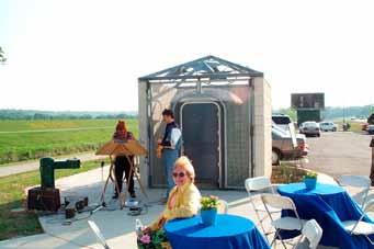
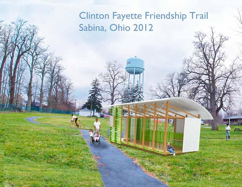
7 Proposed Clinton Fayette Friendship rail: abina, hio 7.
8 rails re Important For iverse easons: ransportation ecreation xercise ccess to nvironment 8.
9 rail Funding + dministration he development of a comprehensive trail and greenway system in Clinton County requires a more comprehensive funding mechanism for the development, maintenance and repair of the trail system. If trails and greenways are a countywide and regional asset, they must be funded at the broadest level possible for the development to be successful and sustainable. Finding: - he development of a comprehensive trail and greenway system in Clinton County requires a more comprehensive funding mechanism for the development, maintenance and repair of the trail system. If trails and greenways are a countywide and regional asset, they must be funded at the broadest level possible for the development to be successful and sustainable. - rail maintenance and management is scalable depending on resources, but should be viewed as a countywide and regional effort. combination or the structured collaboration of the existing parks districts or the creation of a regional trails district is imperative for the future development of trails and greenways in Clinton County. In addition to traditional forms of funding, such as grants, alternative mechanisms for funding trail development and maintenance should be explored. 9.

10 ction: + xplore the merger of the City and County Parks istricts to create a Clinton etroparks type system which could seek future park and recreational levies from a broader population base than just the City of ilmington. + ork collaboratively with the existing City, Villages, ownships and County to ensure collaboration and coordination on this plan and other efforts. eek signed cooperative agreements between the local entities regarding trail development, maintenance and repair efforts. + Create tax increment financing, special improvement district or other trail development district, coordinated by the City and County Park istricts or a etro Parks, which could fund construction of buffering improvements and maintenance of adjacent trails through the incremental increase in property values. hrough a tax increment approach, a portion of new value derived from trail proximity could provide funding for increased development, improvement, and maintenance of the trail system. + rails are an important part of the Parks and ecreation offerings. ll park boards and districts should include trail expansion and trail maintenance in their annual operating and capital budgets, and in future fundraising efforts. + he Clinton County rails Coalition, along with City, County, Villages, ownships and other stakeholders should continue to pursue grant funding for construction of trail corridors identified. he rails Coalition should also consider charitable trusts and land conservation easements, marketed to property owners on or adjacent to proposed trail development which would allow future trail corridor acquisition and provide tax benefits to the current landowners. 10.

11 Bikeways on County oadways hile off roadway trail development is the priority of this plan, Clinton County has existing roadways which serve as important linkages across the County. his Plan highlights the best and worst existing roadways for biking, with the best roadways noted as bikeways. hese bikeways should be prioritized for bike awareness signage and other safety efforts, while the worst roadways should be highlighted for improvements when investment is scheduled for those corridors in the future. Finding: - here possible, off roadway trail development should be encouraged and prioritized. In places where trail development is not possible or unlikely in the future, existing roadways serve as an important part of the bike transportation network in Clinton County. he use of chip and seal pavement techniques should be limited to the greatest extent possible on the bikeway designated roadways below, in cases where this is unavoidable, the roadway should be immediately swept following the chip and seal. ction: + s biking opportunities bring important recreation and tourism, existing roadways which are considering valuable for biking for connectivity, safety or scenic value should be highlighted and those roadways most dangerous for biking should be examined as future improvements are possible. + oadways considered the best for biking in Clinton County Bikeways, and which should be considered for bike awareness signage: H134 orth of ilmington Prairie oad orth of ilmington elson oad and Center oad orth and est of ilmington Gurneyville oad from U68 to ew Burlington oad Cuba oad outh of ilmington artinsville oad between Cuba and artinsville U22&H3 between the arren County line and ilmington + oadways considered the worst and most dangerous for biking in Clinton County should be considered for future additional carriage-way paving, along with safety signage at hills and curves- in an effort to create safer shoulder areas for biking on these roadways: H72 from Greene County to Highland County H134 outh of ilmington U68 orth and outh of ilmington H73 est of ilmington he use of chip and seal pavement techniques should be limited to the greatest extent possible on bikeway (black) designated roadways. 11.
12 C U 72 9 P 729 C C BU 4 13 F HI B B I 71 C F F 73 G U 22 CU B 73 FIH U U 68 I I ynchburg U B I Z K GV CHBU G U 22 µ 1 inch = 1.21 miles I 350 U 3 CH 73 U H U 68 V V C H IFCK B B U 22 U IPKI 34 I K ew Vienna 28 PHIIP PCH C C V I QUIG C U G P K B 8 U 6 I CKIBB HU 1 VI CUB U 68 I UH IC ICH G I P B C H 3 80 U 68 I H I C P G B II H ICK I B H P U IV HH HIIG H I I 13 2 V V P I V H H tate Park oad I FI 28 Path: C:\VProjects\2013 Project Files\BeastandorstoadsforBikingClintonCountyhio.mxd CU G G H U 68 CK H CK H C P U I K ' C K C G 25 1 County oad 3 12 U Highway ownship oad PIK U B P 3 tate oute HI C CH HI C Interstate B H I PI J oad ype 13 K G I BI H I 72 H C F C U I K FIG I C C IV H CH BU G HU CU I K CJU C B I Z H IC C H I V PI F F I F H - U G B I I V F GU F H Blanchester C C B CH I Z F U B treets -- oads unicipal oad C I CH artinsville idland 28 PIK I 28 H K C I C PH KIG B B Z H V GI I F JH U H FI H I U I K X 350 C C C V U H U H I I IV I B CU 3 J 13 C B KU H I I I FIF G P I I B KU G UI Q P H P B C H I V 350 U 22 IC GU P C C X U 73 C H B I B P B 134 P 3 13 K B CH K G I K UV abina I K CC I V I H B U 22 K P I P K J 73 G U G HI B P 0 73 K ay C C I GU C U CI H U CC ss ilmington V G gre Pro V CH B FIF CHG V KH I P VI G K C G Clarksville JI B V I H I K V V 350 CU I C HG 9 72 BB G B I V J K C H G K C B H I C B C K 22 I I P V F I 71 U U 22 H I G K HU IGGI K CH HI H CH P HKI P BBBI V V PC 1 I7 BI VI 73 B VIC G C U B B P CH G KI Best oads K I I orst oads K F P Classification I GI CK Biking Clinton County oads 72 U B BI B I V ZI I H P U 1 I7 I BU 72 V 73 U G H BI GU 380 C C I G G I GI P I Port illiam H I HU B UCK U U 72 Bike-ays II P H U G B B U I G FUK 68 U Z Clinton County Bikeways
13 F K BH V I P K U 73 ilmington rails U rails ICH PIC U HIC K IG V G ytle Creek VICI CP K PK CUI I CI X G V CH C V PGG CU K IG HIG V FIGU PI FI #3 K FIGU #5 K HK P V IB G HH U JPHI H U I UH PC BIK I HICK ICH P C FQUH V IGH P H H V ytle Creek ytle Creek BIC PH FI CI GUP BU IHF V UHIG V U V GV XI V UI H CU UG KUCK V VI PIG ICHIG V II V UB I HI V FU UB UH B K V PVI V UH U U VI I IC BI UG I V C V H CKI IB V FI V UB V CP V CH H V B V IH V FICH HIGH CUBU CU PI V XF PK CUI V G I GII CI UI PII V BB CK II UG FC V B CG K BV KH HI V K PII CK XIG J PII PII V H QUK JH I PPG HIGGI I V K CUBU VI FCU P UI CI BHI 4C BICI BIK I C ' IV BIK I JU G CUI I PII FIF V X IG CI CI HI BCH V VI FI FIF Progress ay HU U KIIG I FU IP Progress ay H CC PK G BUCK 73 V U 22 CC I egend ilmington Potential rails treets -- oads oad ype Interstate tate oute U Highway County oad ownship oad unicipal oad tate Park oad I B B IG JI P IG BI P B 73 U 73 ICH C BB J I 730 CUB CGUI ilson Creek IC UHI BV U 68 I Cowan Creek 134 C H' HP Cowan Creek IB Indian un JKI Cowan Creek ICH µ 1 inch = 0.21 miles Path: C:\VProjects\2012 Project Files\ilmingtonPotentialrails24x36.mxd 13.
14 KI CHP abina rails BU 729 ilson Creek H PK FC V U 22 I P HI V PK V G V C CG FC V UI HU HIG U K HI VI CH V V JFF I V CG C I V JFF H V F H V H H PK JCK H V I CHII C 729 HB V G G PK V U CK V H C V H FI C PP BI HP F K H CI P KB JCK V CKHU HIG HU BI GFI BI U 22 Village of abina Path: C:\VProjects\2013 Project Files\abinaegionalPlanning.mxd 1 inch = 400 feet egend rails lternative 14.
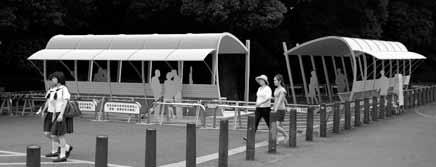
15 VI C Blanchester rails KI-B 28 G I B IB KI HIGH V IF Cemetery G I B V econd Creek BUB P PIK IGH B JH JH I I ZB BI I P U CH CI CH VI C CHUCH H I FC HVI C 133 CUBU BI GV F I C V B C JH GV HIGH B UPIG CK B BUUGH C C CK CUBU IGH VI P VI UPIG U VI BCH HP CH H G V V FC I H 28 CI CH 28 HIG CH 28 U Village of Blanchester iles K GV V P GV V F PK V BCK B H C egend rails 133 FVI tonelick Creek FIGU FIVI 123 PK PC CKZI C H C Path: C:\VProjects\2012 Project Files\BlanchesteregionalPlanning.mxd 15.
16 PIGHI Clarksville rails odds Fork CK CBB PBB FIFH odds Fork I V PI V 4H ast Fork of odds Fork I 2 B 2 PI V C UG FI ewell un CKVI Village of Clarksville 1 inch = 200 feet G UH UG G VI H B I egend rails Path: C:\VProjects\2012 Project Files\ClarksvilleegionalPlanning.mxd 16.

17 Greenway evelopment Finding: - Greenways are linear corridors or ribbons of natural or generally undisturbed lands which link people, places and wildlife- this may include topographic features, streams, utility or railroad corridors, etc. Highlighting and utilizing the existing greenway corridors in Clinton County is an important tool to develop future trails and other linear networks. ction: + Greenway areas should be preserved in their natural state, with no change to the natural slope and vegetation (except the removal of invasive species), especially within the greenway corridors highlighted in this plan. Both the County and City have adopted riparian area setbacks which should be enforced. + he ytle Creek Greenway serves as the most important corridor in the County as it presents the best balance of environmental assets with population proximity. he ytle Creek Greenway should be developed to include both passive environmental preservation and active trail development. + reas of parcels along the ytle Creek Greenway should be dedicated to permanent preservation where possible, with landowners considering conservation easements, land donations or other mechanisms especially within a 100ft. critical buffer area of ytle Creek. + Permanent farmland preservation, through agricultural easement or other means, is a crucial step to the preservation of greenway and other natural habitats. his Plan prioritizes the work of Clinton County pen ands and other land trust organizations to secure permanent agricultural easements across the County, especially in or adjacent to designated Greenways. + Future storm water management fees collected by the City should include a portion of funds to the care and maintenance of the ytle Creek Greenway as this stream is tasked with all of the storm water for the City of ilmington. + tream monitoring programs and awareness signing of local streams should be a priority as it increases the understanding of local environmental assets and environmental impacts- changes in stream chemistry composition and local invertebrate census counts is often a first sign of more serious environmental impacts. 17.
18 B I H H BU BU F H H H F K PH I IP C I P FI H C I U V P P H I I C V B µµ 13 4 inch = 1.29 mile 1 inch = miles 13 4 V FI H C F K F 28 V PH I IP C HI B C F G QUIG HI B PCH F PCH QUIG G HIGH G K K G Z Z Path: C:\VProjects\2012 Project Files\GreenwayapCountyide24x36.mxd C CK IBB HIGH B V K G U I I CH U 68 CH U 68 P U C V B CK IBB K B V U C U 68 V B I V I CUB I U C G B CU U C V 4 13 IC H U I V 68 U H C B P IK P IK B CU V P H C H H P G P H U U IV IV HIIG HIIG 4 13 IC H U CUB 68 U I P H C B I B C GP C C FUK HH CU ICH G I CU B G ICH H H G I P K C CU 13 P tate Park oa tate Park oad I B HH G P U I H G B II II ' K C G U 68 CU CK P U CK H C I I H CK CK H I H H C I ' K 1 K I 2 K ICK C I C ICK V V J I CHB UG H U C ownship oadownship oad H V 4 CU B IP KI 12 U Highway I tate oute U Highway I CU B IP KI Interstate tate oute V U I CH HI FI K PI F V K 28 Interstate County oad County oad B KIG I H J HI H 9 H PI F U 72 C U 68 H H U U I G oad ype oad ype P 13 3 K C F I I I C G I 1 2 K F U B 13 K B V F K I I B PI V F FI I C I 3 treets --treets oads -- oad 72 F IG 13 H I PH U H V P U HU B I I K U FI I K CHB UG C KIG H I B P I B CC U PH IFC H B U H K G B I I IFC H CH 1 H I 25 B 9 B P 1 B I I 72 I B 25 K K G G G C FI P I C U J HU 3 12 HB 72 H C C G HI G H F IG U C C C H I H unicipal oadunicipal oad X G H H C H I J X C K H HB X IF X F CC H C K P C 3 12 KI HU KI U CJ CU C U 22 U 22 FIF CC K I C C B I C J B C G H C B C C C I C H U 350 U I CH IC U C I H CC F H H C C C I I B Z Z F F C CC J VI B J K I Z 28 I I U CC V K I VI C B U Z C B C I H BCH V F B B K B I B 350 B H U 22 U 22 U 22 B CU Greenway rea Greenway reas B H CK U B I B P B P CH 3 50 KI B FIF 134 B U H egend egend I HU CK K U GU B CU C P K P CH I 134 I K P BU H KI C I B C CH B I P I C P I I BU P C BI P H C 72 CH P I I J KU P C Greenways Greenways H CH P C U I K P BI U 22 BI P PI H B B H K C B IC 73 I V P K KU U 28 H FIF 3 50 CU C ay I VI V P BCH CU I H U H U CJ s es G I UI I GU U VI H I G V I - V H C CH FC I F F I C F C U CK gr U K I C CH BI P H P C U FC PI B G I F I K G I IGGI I P IGGI G C 0 73 B P K U H F CH 73 U G K K H ay I B U GU I IV H U Pro CU I C HG V UI H ZI VI K s es gr ro KP P C I7 72 VI K I C 1 BBBI B B B B CH G C C J I UI I G H CH P V K 0 73 GU I HKI HKI H Q 72 V BBBI G C HG V P K H UV CK I P I C F C VI GU 3 P CH H - H VI B I 13 J I I IV I I GU I I K G UI I I - V K P P K H K CH I UV H I B Q 3 P I V K I I 13 I H B P P I G VI C 3 22 U I 13 G B C C CH I CH 0 K 73 P P G C 35 K G B P G C VI HI G I V G BB K 0 35 G G VI B C GI J H K F C G K I B V G BB G C K I ZI C GI I7 2 K U I G BI V F G C C I G 73 B 22 GI 7 I G 1 I7 U V H J B G HI G G BI VI C B U VI 73 I 71 I 71 I B H I 71 I 1 I7 73 V G VI C H I K I V H I V V K I B U GU I I G H C I B GU C I G 1 GI I H I HU I I P I P I I I HU B U CK U B U CK U P 72 G 72 U G U B B Z G G U U B U I G B U I G FUK Z I I Clinton County Greenways 18.

19 Park + rail Intersection evelopment here possible, site trailhead facilities at junction points of multiple activities and alternate means of transportation. hese nodes of mixed use often increase overall activity. rail evelopment Potentials ew Bike ervices Business ew Food Business ew est + ecreation ervices rea ew ourism Information rea 19.
20 rial esign + Construction he Clinton County trail system should be accessible, encourage use by a variety of users, and be designed to be as multipurpose as possible. here are commonly accepted multipurpose trail construction techniques and best practices, including standard hio epartment of ransportation standards which should be utilized for future trail development in Clinton County to ensure public access and safety. he Plan also suggests the included common design elements be accepted as a standard and incorporated in future trail development to ensure that the trail system has a unified look. Finding: - Consistent trail implementation and construction throughout Clinton County will create a uniform brand and experience that stresses the advantages and unique style of the area as presented in this plan. ction: + ew trail development should incorporate aspects of the design strategies summarized within this plan and structural design of trailheads, signage, and consistent themes should be used across the trail network within the County. + reas along existing and new trail development, especially at trailhead locations should include interpretative spaces where information on local history and the local environment could be presented and showcased. 20.

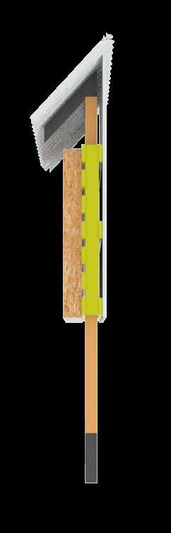
21 rail esign lements + hile much of the trail construction will be quite standard, there are trail amenities that provide opportunity to create unique user experiences, when their design is integrated into the place. unique design can create a memorable association with the activity and the place in which it occurs. Covered in the following pages are design typologies for trailhead shelters, covered bridges, trail kiosks, and rough overview of trail construction itself. + aterial selection was driven by a survey of local building materials and components produced in the area. uch of the land intended for trail development is along agricultural land, and the few built structures visible along those routes use the corrugated metal for their grain bins. ecycling this material into trailhead shelters bridges, and kiosks provides some visual continuity sense of place. nother prevalent building material are shipping pallets, which can be created locally through our wood processing plants and logistics companies. + he trail architecture and signage can enhance recreation, environmental and commercial areas if the siting and design of those facilities aims to accommodate both the existing attributes of the site and the planned use. 21.


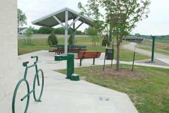
22 ypical railhead menities: helter from precipitation, access to water, toilets, signage + maps 22.


23 railhead Pavilion xamples 23.
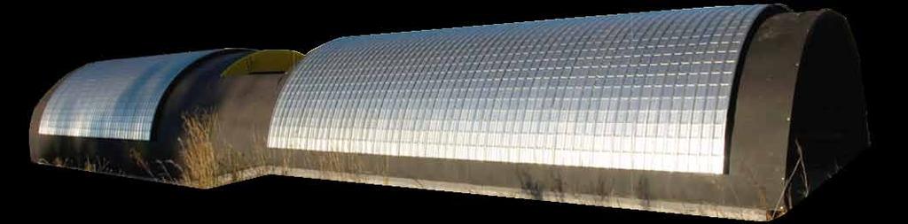

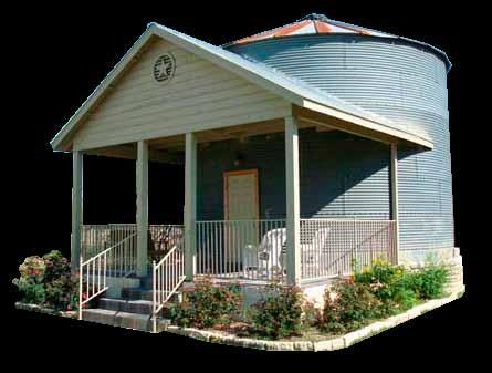

24 elected rchitecture aterials xamples of eclaimed Grain ilo rchitecture 24.
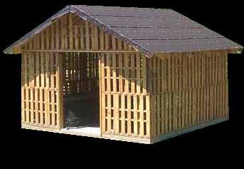
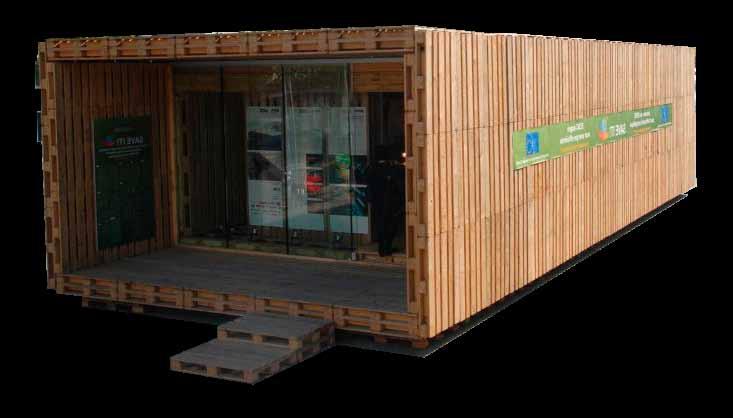

25 elected rchitecture aterials xamples of Palette tructures 25.
26 xample of Pavilion ayout wc bike parking seating info. 26. pavilion_1


27 xample of Pavilion ayout wc 27. pavilion_2

28 arly endition of Pavilion 28.


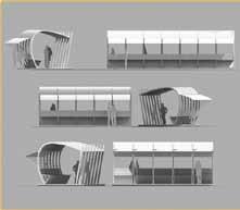
29 Proposed Vision For Pavilion 29.
30 30.


31 Proposed Kiosk esign 31.


32 xisting Kiosk Proposed Kiosk 32.

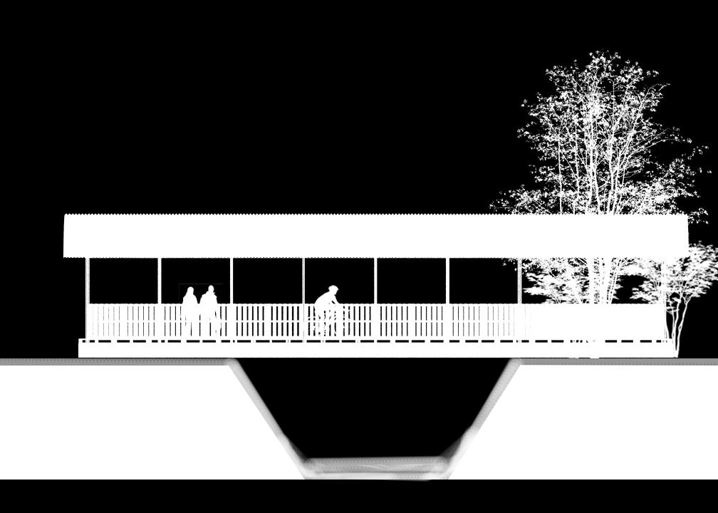
33 Covered Bridge rchitecture 33.

34 xisting: Covered Bridge rchitecture 34.


35 Potential esign: odern daptation on Bridge rchitecture 35.


36 Construction Cost stimates: Kiosk: $ Pavilion: $15, Bridge: $20,

37 rail Impact + Buffering rail and greenway development has a positive impact on housing and land values. recent University of Cincinnati study conducted on the nearby ittle iami rail found that homeowners were willing to pay a premium to be in close proximity to the trail. his study complements numerous other national studies which have consistently demonstrated similar results. ven with the positive results, active trail development must also be designed in a way that is sensitive to neighbors and adjacent uses. Finding: - rails are good neighbors; they increase property values and have been consistently found to be safe from a public safety perspective in a variety of situations and neighborhoods. here are well-recognized buffering strategies that allow trails and trail users to be compatible with all adjacent uses. ith the proper design and deployment of buffering techniques that are detailed in this plan, trails are appropriate in nearly every area of Clinton County. ction: + ctive trail development should be buffered in populated areas with a combination of 4 strategies which include: spacing, fencing, plantings and berming where appropriate as detailed in this Plan. 37.

38 CP BUFFIG Fisher Plains tudy 38.

39 Proposed Buffering echniques IX PIG HGIG B 39. G PCIG

40 xample of ixed Plantings 40.

41 xample of ixed Fencing 41.
42 BUFFIG G: Fisher Plains 9 residential backyard potential buffer drain basin trail trees along berm low plantings split-rail fencing 42.


43 endering of Potential Fisher Plains evelopment 43.

44 rail Buffering trategy: abina ooking est - without vegetative buffering 44.

45 rail Buffering trategy: abina ooking est - with vegetative buffering 45.

46 rail Buffering trategy: abina ooking ast 46.
47 Construction etails ypical Path ection: Horizontal Clearance bstructions = 3 desired, 2 min. eparation from oadway = 5 teep mbankment (> 3:1) = 5 : ypical ection of Bikeway on bandoned ailroad Vertical Clearance 10 desired, 8 min. idth Path idth = 10 Graded houlder = 2 Bridge or unnel idth = 14 Cross lope Path lope = 2% pref., 3% max o crown Graded houlder = 12:1 pref., 6:1 max. Pavement Composition esign for expected emergency, law enforcement, & maintenance vehicles commercial drive design is recommended ection rawing (right): Bike esign on bandoned ailroad 47.
 9 below edge of path, pref. 0 below edge of path, min. Vertical lignment: ax.")
48 rainage: Use Bicycle safe grates (4 max. grid spacing) Provide ditch on uphill side of the path Culvert design per ocation & esign anual itch flow depth per & section (istrict 12) 9 below edge of path, pref. 0 below edge of path, min. Vertical lignment: ax. Grade Break w/o a vertical curve ot addressed directly in H Use ocation & esign anual (&) Figure inimum length of vertical curve stablish topping ight istance () for crest curve ecommended peed: 30mph = 1.30% 20mph= 2.9% 48.
49 esign eferences: H Guidelines for the evelopment of Bicycle Facilities, (1999 or latest edition) FH Publication o. FH-P , Best Practices esign Guide Part 2, esigning idewalks and rails for ccess, (2001) UC hio anual of Uniform raffic Control evices (2005 or latest edition, Chapter 9) 49.
Chapter 6: POLICY AND PROCEDURE RECOMMENDATIONS
 Chapter 6 POLICY AND PROCEDURE RECOMMENDATIONS FOR SRRA Below are seven policy elements that should be considered for adoption by the Southwest Regional Recreation Authority of Virginia: 1. Develop strategies
Blueways: Rivers, lakes, or streams with public access for recreation that includes fishing, nature observation, and opportunities for boating.
 Parks, Open Space and Trails PRINCE WILLIAM COUNTY 2008 COMPREHENSIVE PLAN TRAILS PLAN CONTENTS The components of the trails plan are: Intent Definitions Goals, Policies, and Action Strategies Trails Map
2. Goals and Policies. The following are the adopted Parks and Trails Goals for Stillwater Township:
 D. PARKS AND TRAILS 1. Introduction Stillwater Township s population is relatively low, with most residents living on rural residences on large lots. The need for active park space has been minimal in
City of Durango 5.8 FUNDING TRAILS DEVELOPMENT
 5.8 FUNDING TRAILS DEVELOPMENT The City has been successful in establishing dedicated local funding sources as well as applying for grants to develop the City s trail system, having received nearly $2.4
Georgetown-Lewes Rail/Trail Study. Rail/Trail Study: Cool Spring to Cape Henlopen State Park New Road Extension (House Resolution No.
 Georgetown-Lewes Rail/Trail Study Rail/Trail Study: Cool Spring to Cape Henlopen State Park New Road Extension (House Resolution No. 47) August 22, 2011 Presentation Outline Background Benefits Statewide
$866,000. $1,400,000 Health Benefits $13,156,000 TOTAL ANNUAL DIRECT BENEFITS. $10,890,000 Economic Benefits
 SINGING RIVER TRAIL Trails Create Value + Generate Economic Activity Trails generate economic returns through improved health, safety, and environmental conditions, raise property values, and attract visitors.
RFTA REGIONAL BICYCLE, PEDESTRIAN AND TRANSIT ACCESS PLAN. Map A.7: El Jebel/Willits Existing Conditions Map. A-8 Exisiting Conditions Maps
 I F GIO ICYC, I I CC HIGH issouri Heights ew multi-use trail connects north l Jebel to general store and H- underpass G egional icycle, edestrian and ransit ccess lan eighborhood trail connects residents
AGENDA ITEM 5 D WAKULLA ENVIRONMENTAL INSTITUTE (WEI) TRAIL FEASIBILITY STUDY
 TRAIL FEASIBILITY STUDY") March 19, 2018 AGENDA ITEM 5 D WAKULLA ENVIRONMENTAL INSTITUTE (WEI) TRAIL FEASIBILITY STUDY TYPE OF ITEM: Action STATEMENT OF ISSUE The Wakulla Environmental Institute (WEI) Trail is one of several trails
March 19, 2018 AGENDA ITEM 5 D WAKULLA ENVIRONMENTAL INSTITUTE (WEI) TRAIL FEASIBILITY STUDY TYPE OF ITEM: Action STATEMENT OF ISSUE The Wakulla Environmental Institute (WEI) Trail is one of several trails
CHAPTER 9. PARKS, RECREATION, TRAILS AND NATURAL AREA RESOURCES
 CHAPTER 9. PARKS, RECREATION, TRAILS AND NATURAL AREA RESOURCES The forms of recreation chosen by residents and visitors in the CBJ are as diverse as the population. Many people choose to recreate in developed
Tallahassee-St. Marks Historic Railroad Trail
 Revitalizing a Historic Trail Designated as a National Recreation Trail, the 16-mile Tallahassee-St. Marks Historic Railroad Trail has been enjoyed by countless bicyclists, runners, and outdoor enthusiasts
BUCKS COUNTY TRAILS. September 10, 2015 Presentation to:
 BUCKS COUNTY TRAILS September 10, 2015 Presentation to: BUCKS COUNTY TRAILS Benefits of Trails Bucks County Trails The Circuit Active Trail Projects Planning Studies Municipal Trails Planning Other Trail
FEASIBILITY CRITERIA
 This chapter describes the methodology and criteria used to evaluate the feasibility of developing trails throughout the study areas. Land availability, habitat sensitivity, roadway crossings and on-street
CHAPTER 5. Chapter 5 Recreation Element
 CHAPTER 5 Recreation Element Chapter 5 Recreation Element The Recreation Element of the Meyers Area Plan is a supplement to the Recreation Element of the TRPA Regional Plan and the El Dorado County General
Business Item No
 Metropolitan Parks and Open Space Commission Meeting date: February 6, 2018 For the Community Development Committee meeting of February 20, 2018 For the Metropolitan Council meeting of February 28, 2018
Chapter 6. Action Program. Heart of the Lakes Area Recreation Plan
 Heart of the Lakes Area Recreation Plan 1. Design and construct the following trails (please see the following map): a. the Speedway Trail 1) primary pathway the main trail 2) secondary pathway the proposed
Gardner: overview. Santa Fe, Oregon, and California National Historic Trails UNINCORPORATED JOHNSON COUNTY OLATHE UNINCORPORATED JOHNSON COUNTY
 Santa Fe, Oregon, and California ational Historic Trails : overview 99: p.134 100: p.135 GARDER JUCTIO 102: p.137 56: p.126 EDGERTO Burlington orthern Intermodal and Logistics 98: p.133 101: p.136 S Waverly
AECOM City of London Pedestrian Pathway Connection Across CNR Lands in Kiwanis Park Municipal Class Environmental Assessment Screening Report
 ity of ondon Pedestrian Pathway onnection cross ands unicipal lass nvironmental ssessment creening eport xecutive ummary Introduction he ity of ondon (ity) initiated a unicipal lass nvironmental ssessment
Blue River Trail Master Plan JSA to Town Hall June 2004
 Blue River Trail Master Plan JSA to Town Hall June 2004 Prepared for: Silverthorne Town Council Silverthorne SPORT Committee Department of Recreation and Culture Silverthorne Public Works Silverthorne
Waukee Trailhead Public Art and Amenities Project
 Waukee - Trailhead Public Art and Amenities Project Sponsor Waukee Project Title Waukee Trailhead Public Art and Amenities Project Termini Description ( i.e. Park Avenue to 19th Street) NE Intersection
Economic Development and Tourism
 SECTION 4 SECTION 4 Economic Development and Tourism 4. Economic Development and Tourism Tourism plays a very important role in Niagara s economy, providing employment and generating business for support
Classifications, Inventory and Level of Service
 Classifications, Inventory and Level of Service Section 3 Kenmore Park, Recreation and Open Space Plan 1 P a g e Classifications and Inventory Park Classifications Kenmore classifies its parks based upon
Trails. Lois Jensen Nature Preserve is a 30 acre parcel on the north end of the city. It provides unspoiled wooded paths.
 Trails Lois Jensen Nature Preserve is a 30 acre parcel on the north end of the city. It provides unspoiled wooded paths. TRAIL S, PATHS, ROUTES AND CONNECTORS Citizen input pointed to trails, paths, bike
CHAPTER ONE LITERATURE REVIEW
 CHAPTER ONE LITERATURE REVIEW LITERATURE REVIEW This chapter summarizes the most recently published community impact studies and articles that relate to multiuse trails. The review focuses on publications
A&H Project Proposal 2017
 & Project Proposal Project itle: oos ountain ravel anagement rea () pplicant: regon epartment of ish and ildlife (); arnes & ssociates, Inc; ureau of Land anagement; eyerhaeuser ompany; oseburg orest Products
Longmont to Boulder Regional Trail Jay Road Connection DRAFT FINAL REPORT
 Longmont to Boulder Regional Trail Jay Road Connection DRAFT FINAL REPORT December 2018 Project Summary Boulder County, Colorado, in partnership with the City of Boulder, is evaluating options for multi-use
MORGAN CREEK GREENWAY Final Report APPENDICES
 APPENDICES MORGAN CREEK GREENWAY Appendix A Photos of Existing Conditions in Trail Corridor Photos of existing conditions Main trail corridor - February 2009 Photos of existing conditions south bank Morgan
MARCELLUS DESIGN HISTORIC ROUTE 6 SENSE OF PLACE HABITATS AND CORRIDORS RECREATION HISTORIC SITES AND LANDSCAPES WATER FOOD AND ENERGY FUTURES
 he ennsylvania tate niversity istoric oute highway spanning across the country, istoric oute runs through a multitude of landscapes : towns, cities, mountains, plateaus, rivers, lakes, forests and everything
Assessing Your Trails, Keeping Them Safe and Enjoyable
 Jon Wood, PLA, ASLA Associate Vice President Stewart Bert Lynn, PLA, ASLA, LEED AP Project Manager Mecklenburg County Asset and Facility Management Assessing Your Trails, Keeping Them Safe and Enjoyable
The Future of the Road to Revolutions. A Battle Road Scenic Byway Public Forum November 9, 2010
 The Future of the Road to Revolutions A Battle Road Scenic Byway Public Forum November 9, 2010 Who is the Battle Road Scenic Byway? Four Towns: Arlington, Lexington, Lincoln, Concord Minute Man National
Wilds. Headwaters. Lakes. Oxbows. Falls
 56 5 4 3 Wilds Headwaters Lakes Oxbows Falls 57 Zones It could be said the on-the-ground essence of this master plan appears within the next 6 pages of this report. As we learned in the preceding Cultural
SUMTER COUNTY ANNUAL TRAFFIC COUNT PROGRAM 2017 TRAFFIC REPORT
 U U U FFI U PG FFI P very year, the ake~umter etropolitan Planning rganization (P), in cooperation and partnership with umter ounty Public orks epartment, implements a traffic count program. he P collects
SUMMER VILLAGE OF SILVER SANDS. Municipal Development Plan
 SUMMER VILLAGE OF SILVER SANDS Municipal Development Plan Bylaw 253-2014 Adopted August 22, 2014 Summer Village of Silver Sands Municipal Development Plan Bylaw No. 253-2014 Page 2 1 INTRODUCTION 1.1 SETTING
Manatee County Impact Fee Schedule Effective April 18, 2016 (1)
") anatee County Impact Fee Schedule ffective pril 8, 206 nf. ulti-odal ransportation atural esrcs duc dmin. SIIL (Per Housing Unit) SIGL-FILY CH 000 sq ft or less $78 $95 $2,290 $2,85 $,686 $,335 $430 $96
anatee County Impact Fee Schedule ffective pril 8, 206 nf. ulti-odal ransportation atural esrcs duc dmin. SIIL (Per Housing Unit) SIGL-FILY CH 000 sq ft or less $78 $95 $2,290 $2,85 $,686 $,335 $430 $96
Rogue River Access and Management Plan Draft Alternatives
 Rogue River Access and Management Plan Draft Alternatives The Rogue River Access and Management Plan was initiated in December, 2011 and is being led by Jackson County Parks (JCP) and Oregon Department
Trail # NW Tuesday, June DESIGN. Provide an Review the Provide an. Project Goals: System system. wayfinding
 I. Welcome / Introductions Bethany Creek Trail #2 Segment 3 Neighborhood Meeting #1 Bethany Presbyterian Church 15505 NW Springville Road, Portland, OR 97229 Tuesday, June 26, 2018 @ 6:00PM Meeting Minutes
PURPOSE AND NEED (CONCURRENCE POINT 1) NEW CANADA ROAD PROJECT FROM STATE ROUTE 1 (U.S. HIGHWAY 70) TO U.S. INTERSTATE 40
 NEW CANADA ROAD PROJECT FROM STATE ROUTE 1 (U.S. HIGHWAY 70) TO U.S. INTERSTATE 40") PURPOSE AND NEED (CONCURRENCE POINT 1) NEW CANADA ROAD PROJECT FROM STATE ROUTE 1 (U.S. HIGHWAY 70) TO U.S. INTERSTATE 40 Project Description The primary purpose of this project is to improve the major
PURPOSE AND NEED (CONCURRENCE POINT 1) NEW CANADA ROAD PROJECT FROM STATE ROUTE 1 (U.S. HIGHWAY 70) TO U.S. INTERSTATE 40 Project Description The primary purpose of this project is to improve the major
North Shore Lacamas Lake
 North Shore Lacamas Lake January 27, 2017 A Vision for Conservation and Recreation Acknowledgements Funding Funding for this planning effort was provided by the City of Camas and the Columbia Land rust
Welcome to the future of Terwillegar Park a Unique Natural Park
 Welcome to the future of Terwillegar Park a Unique Natural Park 1 Introduction The Terwillegar Park Concept Plan study will develop an overall concept plan, management objectives and development guidelines
SOUTH INTERCHANGE AREA
 Santaquin City General Plan 1 Location and Characteristics The South Interchange Area of Santaquin is located west of Interstate 15 and south of 500 South (Figure 1). It includes properties already annexed
chapter - Hex Highway Touring Route Hamburg to Strausstown Overview
 chapter - 2 Hex Highway Touring Route Hamburg to Strausstown Overview The on-road Hex Highway automobile and bicycle touring route begins on State Street in downtown Hamburg. The route continues west on
Hudson Highlands Fjord Trail Draft Master Plan. April 29, 2015
 Hudson Highlands Fjord Trail Draft Master Plan April 29, 2015 Agenda Route Overview Proposed Segment Results of Community Survey on that Segment Next Steps Municipal Endorsement Environmental Review Implementation
Wallace Falls State Park Classification and Management Planning Stage 3 Preliminary Recommendations July 18, 2018 Sultan City Hall
 Wallace Falls State Park Classification and Management Planning Stage 3 Preliminary Recommendations July 18, 2018 Sultan City Hall Thanks for coming! This document contains State Parks preliminary recommendations
Rule Governing the Designation and Establishment of All-Terrain Vehicle Use Trails on State Land
 Rule Governing the Designation and Establishment of All-Terrain Vehicle Use Trails on State Land 1.0 Authority 1.1 This rule is promulgated pursuant to 23 V.S.A. 3506. Section 3506 (b)(4) states that an
Minutes Brice Prairie Safety Committee Wednesday, May 2, 2018 Brice Prairie First Responders Building
 Minutes Brice Prairie Safety Committee Wednesday, May 2, 2018 Brice Prairie First Responders Building Members Present: Brian Tippetts, Vicki Burke, Jim Nissen, Jerri Monti, Dave DeBoe, Jolene Huiss, Fritz
Northaven Trail Phase 2 Initial Project Overview
 Northaven Trail Phase 2 Initial Project Overview Partnership Project to extend existing Northaven Trail Improve Bike/Ped Connectivity On Dallas Trail Network Plan City and County Funding Oncor Texas Trails
Regional Wayfinding Sign Strategy Thurston County Trails 2017
 Regional Wayfinding Sign Strategy Thurston County Trails 2017 Partners: Members and partnering organizations of the Thurston Thrives Community Design Action Team City of Lacey, City of Olympia, City of
APPENDIX OFFICIAL MAP ORDINANCE OF HAMILTONBAN TOWNSHIP OFFICIAL MAP NARRATIVE
 APPENDIX A OFFICIAL MAP ORDINANCE OF HAMILTONBAN TOWNSHIP OFFICIAL MAP NARRATIVE INTRODUCTION: The Official Map of Hamiltonban Township has been prepared to identify those lands and features that Hamiltonban
11. Recreational Trails and Pathways Needs
 11. Recreational Trails and Pathways Needs Background Walking, biking, hiking, in-line skating, canoeing, and other trail- and pathway-related activities are important to Boiseans. This importance is demonstrated
A CASE FOR COMPLETING THE JORDAN RIVER PARKWAY: A
 A CASE FOR COMPLETING THE JORDAN RIVER PARKWAY: A safe crossing at 9000 South and 850 West Proposed 9000 South Underpass Parkway Timeline Parkway, Trail, and Tourism Facts Blueprint Jordan River 1971 1973
Coast to Coast Connector Summit
 Project Partners Welcome to the Coast to Coast Connector Summit Winter Garden, Florida City Hall October 1, 2014 1 Why are we here? Objectives 1. Inform key stakeholders on the current state of the C2C
Appendix 3. Greenway Design Standards. The Whitemarsh Township Greenway Plan
 Appendix 3 Greenway Design Standards This chapter discusses two design standards for the greenway types discussed above. First, trail design standards are presented together with trailhead facilities and
COASTAL CONSERVANCY. Staff Recommendation December 2, 2004 COYOTE HELLYER COUNTY PARK BAY AREA RIDGE TRAIL
 COASTAL CONSERVANCY Staff Recommendation December 2, 2004 COYOTE HELLYER COUNTY PARK BAY AREA RIDGE TRAIL File No. 04-057 Project Manager: Amy Hutzel RECOMMENDED ACTION: Authorization to disburse up to
1 PROJECT STATUS UPDATE 2 ND CONCESSION FROM BRISTOL ROAD TO DOANE ROAD TOWNS OF EAST GWILLIMBURY AND NEWMARKET
 Report No. 3 of the Regional Council Meeting of March 28, 2013 1 PROJECT STATUS UPDATE 2 ND CONCESSION FROM BRISTOL ROAD TO DOANE ROAD TOWNS OF EAST GWILLIMBURY AND NEWMARKET The recommends: 1. Receipt
3.0 LEARNING FROM CHATHAM-KENT S CITIZENS
 3.0 LEARNING FROM CHATHAM-KENT S CITIZENS An important aspect in developing the Chatham-Kent Trails Master Plan was to obtain input from stakeholders and the general public. Throughout the course of the
Section II. Planning & Public Process Planning for the Baker/Carver Regional Trail began in 2010 as a City of Minnetrista initiative.
 Section II Planning & Public Process Planning for the began in 2010 as a City of initiative. city staff began discussions with the Park District on the possibility of a north/south regional trail connection
CHAPTER III: TRAIL DESIGN STANDARDS, SPECIFICATIONS & PERMITS
 CHAPTER III Trail Design Standards, Specifications & Permits This chapter discusses trail standards, preferred surface types for different activities, permits, and other requirements one must consider
Proposal to Redevelop Lower Kananaskis River-Barrier Lake. Bow Valley Provincial Park. Frequently Asked Questions
 Proposal to Redevelop Lower Kananaskis River-Barrier Lake Bow Valley Provincial Park Frequently Asked Questions What is being proposed? What are the details of the proposal? Where is the project area located?
The Baker/Carver Regional Trail is intended to
 Section V Design Guidance The Baker/Carver Regional Trail is intended to safely accommodate 183,000 annual visits, an array of non-motorized uses, a variety of skill levels, and persons with special needs.
Non-Motorized Transportation
 Non-Motorized Transportation Non-motorized facilities are important components to the transportation system. They provide an environmentally-friendly, low-cost mode of travel. Some of the facilities can
COUNTY COMPREHENSIVE PLAN
 50 : Policy Statement Lewis County has a unique and attractive rural character, which makes it a wonderful place to visit and explore. The region abounds with recreation opportunities that attract visitors
Environment and Natural Resources Trust Fund 2019 Request for Proposals (RFP)
") Environment and Natural Resources Trust Fund 2019 Request for Proposals (RFP) Project Title: Glacial Edge Trail and Downtown Pedestrian Bridge Category: G. Land Acquisition for Habitat and Recreation ENRTF
Environment and Natural Resources Trust Fund 2019 Request for Proposals (RFP) Project Title: Glacial Edge Trail and Downtown Pedestrian Bridge Category: G. Land Acquisition for Habitat and Recreation ENRTF
Segment 2: La Crescent to Miller s Corner
 goal of the USFWS refuges is to conserve, protect and enhance fish, wildlife and plants and their habitats for the continuing benefit of the American people. Refuge lands are used largely for fishing,
ANCLOTE COASTAL TRAIL ALTERNATIVES ANALYSIS STUDY
 ANCLOTE COASTAL TRAIL ALTERNATIVES ANALYSIS STUDY PASCO COUNTY MPO JULY 2015 PROJECT OVERVIEW... INTRODUCTION EXECUTIVE SUMMARY CONTEXT... TAMPA BAY AREA, PINELLAS, & PASCO COUNTY S MULTI-USE TRAIL PLANS
PDAC Priority Project East Dayton Rails-to-Trails (Flight Line) Project Description
 Project Description") PDAC Priority Project East Dayton Rails-to-Trails (Flight Line) Project Description The Flight Line project represents an amazing opportunity to become a truly transformative urban recreational trail that
PDAC Priority Project East Dayton Rails-to-Trails (Flight Line) Project Description The Flight Line project represents an amazing opportunity to become a truly transformative urban recreational trail that
This page has been intentionally left blank.
 This page has been intentionally left blank. Chapter 2 2-2 2. Growing the Economy In many ways, the Niagara Region is a community of communities and this is becoming increasingly so. It is made up of towns
THOMAS A. SWIFT METROPARK Introductions History Present Conditions Future Development Plans Implementation Strategies Statistics
 THOMAS A. SWIFT METROPARK Introductions History Present Conditions Future Development Plans Implementation Strategies Statistics Introduction As an open meadow park positioned along the Mahoning River,
J. Recreation Plan of Conservation and Development. The Town of Hebron. Section 2. Preservation of Unique Assets. 1 P a g e
 The Town of Hebron Section 2 2014 Plan of Conservation and Development Preservation of Unique Assets J. Recreation Open spaces, parks, sports fields, and recreational programs are considered essential
REPORT TO THE PARKS AND RECREATION COMMISSION rd Avenue NE, Woodinville, WA
 CITY OF WOODINVILLE, WA REPORT TO THE PARKS AND RECREATION COMMISSION 17301 133rd Avenue NE, Woodinville, WA 98072 WWW.CI.WOODINVILLE.WA.US To: From: Subject: Honorable Parks and Recreation Commission
Florida National Scenic Trail 5-Year Strategic Plan. Barbara Bowen
 Florida National Scenic Trail 5-Year Strategic Plan 2012 Barbara Bowen Florida National Scenic Trail M. Timothy O Keefe M. Timothy O Keefe Mike Knox 20-mile Planning Corridor Florida National Scenic Trail
Northeast Quadrant Distinctive Features
 NORTHEAST QUADRANT Northeast Quadrant Distinctive Features LAND USE The Northeast Quadrant includes all the area within the planning area that is east of Interstate 5 and to the north of State Route 44.
University Region Non-Motorized Plan 2015
 Non-Motorized Transportation Non-motorized facilities are important components to the transportation system. They provide an environmentally-friendly, low-cost mode of travel. Some of the facilities can
DRAFT - APRIL 13, 2007 ROUTING STUDY FOR TRAIL CONNECTIONS BETWEEN CALAIS AND AYERS JUNCTION
 DRAFT - APRIL 13, 2007 ROUTING STUDY FOR TRAIL CONNECTIONS BETWEEN CALAIS AND AYERS JUNCTION Abstract The vision for the East Coast Greenway is an off-road urban trail system running from Calais, Maine
Chapter eight. Parks and Recreation. Introduction. Crystal Lake Park District
 Chapter eight Parks and Recreation Introduction One of the indicators of quality of life in a city is the parks and recreation system. The City of Crystal Lake is fortunate to have an excellent parks and
Map 1.1 Wenatchee Watershed Land Ownership
 Map 1.1 Wenatchee Watershed Land Ownership Map 1.1 Wenatchee Watershed Land Ownership The Wenatchee watershed lies in the heart of Washington state in Chelan County. Just larger than the state of Rhode
Prior to contacting the Whitecourt Trailblazers Snowmobile Club, applicants must:
 WHITECOURT TRAILBLAZERS Box 607 Whitecourt, AB T7S 1N7 www.whitecourttrailblazers.ca CNT AMENDMENT Restriction Code 710: See Comments Comments All applicants are required to contact: Whitecourt Trailblazers
GOALS, OBJECTIVES, & RECOMMENDATIONS historic preservation. BUDA 2030 COMPREHENSIVE PLAN preserving our heritage sustaining our future
 HISTORIC PRESERVATION Buda has the second largest concentration of historic structures in Hays County, many of which are located along Main Street in downtown Buda. 1 These historic buildings form the
13.1 REGIONAL TOURISM ISSUES AND SUMMARY OF FINDINGS
 13 REGIONAL TOURISM T he County of Mariposa s recreation needs and facilities fall within two categories: regional tourism and local recreation. This Element focuses on regional tourism issues related
MASTER PLAN EXECUTIVE SUMMARY
 Biscuit Run State Park Scottsville Road (State Route 20) Charlottesville, VA 22902 Biscuit Run State Park MASTER PLAN EXECUTIVE SUMMARY Department of Conservation and Recreation Division of Planning and
Committee. Presentation Outline
 CW-33-15 11/9/2015 Community and Corporate Services Committee November 10, 2015 1 Presentation Outline Background Vision and Objectives Study Process and Timeline Public and Stakeholder Engagement Organization
Rating: 5.0 (scale of 1-10)
") 95 Community Trail System Groundcover: 2-metre paved path, 1- metre grass buffer on either side. Location: Fort St. John Ownership: City of Fort St. John Rating: 5.0 (scale of 1-10) Strategic value: Linear
95 Community Trail System Groundcover: 2-metre paved path, 1- metre grass buffer on either side. Location: Fort St. John Ownership: City of Fort St. John Rating: 5.0 (scale of 1-10) Strategic value: Linear
Chapter 2: Summary of Existing Open Space System
 Chapter 2: Summary of Existing Open Space System In 1976, the Wake County Board of Commissioners established the Wake County Parks and Recreation Department in order to provide park facilities and programs
METROPOLITAN COUNCIL 390 North Robert Street, St. Paul, MN Phone (651) TDD (651)
 TDD (651)") METROPOLITAN COUNCIL 390 North Robert Street, St. Paul, MN 55101 Phone (651) 602 1000 TDD (651) 291 0904 DATE: June 19, 2007 TO: Metropolitan Parks and Open Space Commission FROM: Jan Youngquist, Senior
METROPOLITAN COUNCIL 390 North Robert Street, St. Paul, MN 55101 Phone (651) 602 1000 TDD (651) 291 0904 DATE: June 19, 2007 TO: Metropolitan Parks and Open Space Commission FROM: Jan Youngquist, Senior
Lake Myra County Park. Wake County, North Carolina Community Forum #2 June 12, 2008
 Lake Myra County Park Wake County, North Carolina Community Forum #2 June 12, 2008 Welcome and Introduction Meeting Agenda Welcome Introductions of Project Team Master Plan Process Community Forum #1 Updates
Land Management Summary
 photo credit: ANGAIR Anglesea Heath Land Management Summary The Anglesea Heath (6,501 ha) was incorporated into the Great Otway National Park in January 2018. This provides an opportunity to consider the
2016 Regional Transportation Alternatives Program (TAP) Grant Application
 Grant Application") 2016 Regional Transportation Alternatives Program (TAP) Grant Application PROJECT TITLE: Yelm-Tenino Trail Extension Feasibility Study TRPC use only GENERAL PROJECT INFORMATION Agency or Organization City
2016 Regional Transportation Alternatives Program (TAP) Grant Application PROJECT TITLE: Yelm-Tenino Trail Extension Feasibility Study TRPC use only GENERAL PROJECT INFORMATION Agency or Organization City
CHAPTER 3 PLANNING GOALS
 CHAPTER 3 PLANNING GOALS AND PUBLIC INPUT INTRODUCTION This portion of the Algonac Master Plan is intended to outline a course for action in achieving the community s vision for the future. Throughout
City of Solvang SUNNY FIELDS SPUR TRAIL STUDY
 City of Solvang SUNNY FIELDS SPUR TRAIL STUDY project description The City of Solvang, in partnership with the County of Santa Barbara Public Works Department, is developing an alignment study for a proposed
Auburn Trail / Ontario Pathways Trail Connector Feasibility Study Public Information Meeting Wednesday, August 22, 2012
 Auburn Trail / Ontario Pathways Trail Connector Feasibility Study Public Information Meeting Wednesday, August 22, 2012 Purpose of Feasibility Study Purpose Evaluate the feasibility of constructing a multiuse
Jefferson County Non-Motorized Transportation and Recreational Trails Plan 2010
 Chapter 8: Goals and objectives Plan Update: The following update presents general principles, goals, and objectives related to non-motorized transportation facilities as a component of the overall transportation
Recreational Services Plan. Gatineau Park. Phase 1: Planning Framework
 Recreational Services Plan Gatineau Park Phase 1: Planning Framework 1 Plan Planning in Gatineau Park Gatineau Park : an overview Trends Preliminary assessment Strategic framework 2 Unique natural and
Trails Design and Management Handbook
 Trails Design and Management Handbook OPEN SPACE PITKIN AND TRAILS COUNTY Open Space and Tr ails Progr am Pitkin County, Color ado Pitkin County Open Space and Trails Program Trails Design and Management
Appalachian Trail Community
 Harpers Ferry, West Virginia Appalachian Trail Community A Designation Program of the Appalachian Trail Conservancy The Appalachian Trail Conservancy (ATC) mission is to preserve and manage the Appalachian
Railroad Safety Trail
 2.1 INTRODUCTION AND PROJECT SETTING 2.1 Introduction & Project Setting Introduction This study is the result of a directed effort on the part of the City of San Luis Obispo to carry out previously established
Logo Department Name Agency Organization Organization Address Information 5700 North Sabino Canyon Road
 Logo Department Name Agency Organization Organization Address Information United States Forest Coronado National Forest 5700 North Sabino Canyon Road Department of Service Santa Catalina Ranger District
OR MISSION TRAIL ELEMENTARY
 Leawood: overview OVERLAD PARK 24: p.70 I-LA PARK 32: p.72 TOMAHAWK PARK 23: p.69 31: p.71 GEZER PARK OR MISSIO TRAIL ELEMETARY 22: p.68 W 133rd St W 135th St KASAS CITY MO - other segments Beginning/end
2. STAKEHOLDER FEEDBACK // What We Heard
 1. QUARRY ROAD TRAIL // Welcome to the Information Session PROJECT DESCRIPTION WHY WE ARE HERE Quarry Road Trail is a popular commuter trail and recreational area for Calgarians. 1. To report citizen feedback
City Council Workshop July 26, 2010
 Des Moines Trails Connecting a Community City Council Workshop July 26, 2010 1 OVERVIEW Trail Benefits Trails Progress How We Fund Trails What s Next for Trails 2 What is a trail? Paved Trails 10 wide
Public Park System. Township of Derry. Providing natural open space for the recreational use of our residents and guests.
 Township of Derry Public Park System Providing natural open space for the recreational use of our residents and guests. Directory of Recreational Amenities Hershey s Commitment to Recreation Famous candy
APPENDIX A: Survey Instruments
 Three different surveys were conducted during the research phase of the NCHA Trails Study. One questionnaire was designed for elected officials and user groups (general public). The other two questionnaires
CITY OF CHASKA PEDESTRIAN MOVEMENT / TRAILS PLAN FINAL CHAPTER 7 PEDESTRIAN MOVEMENT / TRAILS PLAN. Page 1 of 19, Chapter 7
 FINAL CHAPTER 7 PEDESTRIAN MOVEMENT / TRAILS PLAN Page 1 of 19, Chapter 7 ORDER OF CONTENTS I. INTRODUCTION... 3 II. PURPOSE... 3 III. 2030 COMMUNITY TRAILS SYSTEM PLAN... 4 IV. TRAIL TYPES... 7 A. Regional