WALKER RANCH MANAGEMENT PLAN
|
|
|
- Leslie Pearson
- 6 years ago
- Views:
Transcription

1 WALKER RANCH MANAGEMENT PLAN
2 Boulder County Parks and Open Space Walker Ranch Management Plan July 2013 The Walker Ranch Management Plan provides guidance to Boulder County Parks and Open Space on management goals at Walker Ranch Open Space. Public comments on this draft management plan were accepted from May 15 June 15, A public meeting was held at the Clerk and Recorder s Office in Boulder on June 15 5:30 7:30 p.m., all public comments were analyzed and any necessary revisions to the draft plan were made. The draft plan was presented to the Parks & Open Space Advisory Committee on May 23, 2013, beginning at 6:30 p.m., and the final plan was presented to the Board of County Commissioners at a Public Hearing on July 30, 2013 at 4:30 p.m. For questions about this document or to provide comments, write Jesse Rounds, Resource Planner, Boulder County Parks & Open Space, 5201 St. Vrain Road, Longmont, CO 80503; call ; or e- mail: jrounds@bouldercouny.org. Parks & Open Space Department Boulder County ADOPTED: Chair, Board of County Commissioners Date Page 2
3 Contents Executive Summary Introduction Introduction Property Description Location Acquisition History Existing Land Uses Access Land Use Considerations Adjacent Land Use and Ownership Leases, Easements, Encumbrances, and Rights of Way Boulder County Comprehensive Plan Special Designations Environmental Conservation Areas Colorado Natural Heritage Program Planning Overview Purpose Planning Vision and Goals Vision Statement Goals Relationship to Other Plans, Programs, and Planning Efforts Boulder County Comprehensive Plan Boulder Valley Comprehensive Plan Parks and Open Space Resource Policies Other Federal, State, or Local Plans Surveys Planning Process Climate Change Impacts Management Physical Setting Climate Page 3
4 2.1.2 Topography Geology and Soils Water Resources Natural Resources General Ecology Overall Biological and Conservation Value Vegetation Special Status Species Weeds and Weed Management Wildlife General Wildlife Wildlife Linkages and Corridors Ecosystems Management Direction Conservation Areas Summary of Management Recommendation Forestry Meyer s Gulch The Central Ranch BLM South Forest Management Strategies Forest Restoration Fire Mitigation Aspen Enhancement Prescribed Fire Forestry Management Direction Cultural Resources Cultural Resource Surveys Prehistoric Resources Euro american History Historic Resources Cultural Resource Importance Cultural resource Management Direction Page 4
5 2.8 Recreation Opportunities and Visitor Use Area Character Visitor Services and Facilities Trails and Facilities Management Direction Trails Facilities: Regional Trails Trail Changes and The Wall Alternative Recreation Recreation and Facilities Management Summary Education and Outreach Management Education and Outreach Management Direction Adaptive Management Appendices Appendix A. Works Cited Appendix B. Easements and Rights of way reserved on properties within Walker Ranch Appendix C. Public Comment Appendix D. U.S. National Vegetation Classification System Appendix E. Walker Ranch Plant Species List Appendix F. Walker Ranch Wildlife Species List Appendix G. Walker Ranch Biological Resource Evaluation Appendix H. Team Members Table of Figures Figure 1: Area Context Figure 2: Walker Ranch Property Map Figure 3: Walker Ranch Management Areas Figure 4: Comprehensive Plan Designations Figure 5: Soils and Hydrology Figure 6: Vegetation Figure 7: High Value Wildlife & Vegetation Area Map Page 5
6 Figure 8: Protected Areas Figure 9: Forestry Management Figure 10: Walker Ranch Existing Facilities Figure 11: Proposed Facilities Page 6
7 EXECUTIVE SUMMARY Located west of the City of Boulder in south-central Boulder County, Walker Ranch is one of the most visited parks in the county s Parks and Open Space system. From the beginning, Boulder County Parks and Open Space (BCPOS) has managed the property to balance historic preservation, native habitat protection, and recreation (Walker Ranch Management Plan, 1985). The purpose of this management plan is to update the management of the property to take into account additional land acquisition, major milestones in historic preservation, and to recognize the increasing importance of studying and protecting native ecosystems. Purpose The County Commissioners approved the first Walker Ranch Management Plan in At the time, BCPOS owned and managed over 2,500 acres of the original Walker Ranch property. That first plan recognized the need to maintain and enhance the natural food, cover, and nesting areas for native wildlife; the importance of historic preservation; and the need to only develop a rudimentary trail system. Many of those goals were met early in the development of the Open Space. Now, 28 years after that plan was adopted by the County Commissioners, additional land has been secured to create 3,616 acres of public land. The property is designated a National Historic Landmark, contains over 14 miles of trails, and resources are managed to promote wildlife habitat. While many of the goals of the first plan have been met, the landscape at Walker has changed. The Eldorado Canyon Fire reduced tree cover on the Central Ranch, trail erosion has begun to impact habitat surrounding trails, and changes surrounding the property have impact Walker Ranch itself. The Walker Ranch Management Plan is an update in some respects, but is also an assessment of different circumstances. Since its opening, Walker Ranch has been managed to balance many different purposes. The purpose of this management plan is to carry on that tradition. Management Direction The Walker Ranch Management Plan proposes a number of new ways to manage the property. Again, the purpose is to maintain much of what users have come to expect from the open space while ensuring that the many services the property provides can continue well into the future. Management changes are focused on that need to address specific issues. Historic preservation continues to be a focus of management at Walker Ranch. By maintaining a closure around the Walker Ranch homestead, recognizing the specific standards used to restore the homestead, and committing to continued educational opportunities; it is the goal of BCPOS to bolster the preservation of Walker Ranch. Walker Ranch s variety of habitats, position linking large areas of native habitat, and low level of surrounding development; make it a valuable area from an ecological standpoint. By recognizing this value and conserving particular areas as protected from over-use, BCPOS hopes to safeguard native populations of both plants and animals. Page 7
8 Recreation is the way that most visitors interact with Walker Ranch s landscape. Proximity to Boulder and variety of experiences make Walker Ranch a great destination for recreation. The management plan focuses on addressing deficiencies in the current trail network, offering new experiences, and preparing for regional connections throughout the mountains and down to the plains. Page 8
9 1 INTRODUCTION 1.1 INTRODUCTION This Walker Ranch Management Plan Update is intended to build upon the Walker Ranch Management Plan approved by the County Commissioners in July This first plan covered the areas of Walker Ranch acquired in the original purchase. The management goals and direction are based on a combination of staff work and public outreach. The goals, direction, and actions cover natural resource management; visitor use; and cultural resource protection. The update focuses on carrying forward successes from the original management plan and addressing issues that have developed in the intervening 27 years. Walker Ranch now consists of more than 3,616 acres of Open Space. The park consists of lower montane habitat just west of the City of Boulder in the foothills of the Rocky Mountains. The Ranch s size and location mean that it includes stream corridors, gulches, montane shrublands, meadows, forested slopes, and steep rocky outcrops all of which provide important habitat for plants and wildlife in the lower montane zone. All of these features may have made this property attractive to the earliest European settlers in the area. The ranching and logging practices of these settlers had a distinct impact on the property. Since the property s acquisition by Boulder County, the park has become a popular destination for a wide variety of open space users. The properties diverse habitats have attracted nature lovers for viewing and study. The trails built soon after acquisition; continue to attract hikers, bikers, runners, and dog walkers. Combined with a considered effort to preserve and interpret the ranching past of this property, all of these features make Walker Ranch an important part of the county s Parks and Open Space program and make management a requirement to preserve the property for future users. The main entrances to the property are located directly off Flagstaff Road west of the City of Boulder. Walker Ranch is situated between the western side of the dramatic Flatirons formation and Gross Reservoir to the west (Figure 1: Area Map). The Open Space makes up a significant portion of the Hawkins Gulch, Walker Ranch, Eldorado Canyon Environmental Conservation Area (Boulder County Comp Plan, 1995) and is situated east of the ecologically important Twin Sisters Peak. In 2006, Boulder County received a patent for more than 800 acres of Bureau of Land Management property through the Recreation and Public Purposes Act (R&PPA) along with an additional 125 acres acquired from private landowners, Walker Ranch now includes almost 1,000 acres of rugged and rarely visited land known as BLM South. While this southern area includes no legal public access, the majority of Walker Ranch can be accessed from three BCPOS managed trailheads (Meyers Gulch, Walker Loop, and Ethel Harrold) as well as an unofficial access point from Gross Dam Road and from the State Parks trailhead at Crescent Meadows south of the Walker Loop trail. Boulder County Parks and Open Space acquired the first portions of Walker Ranch from a property development group beginning in 1977 and acquiring the final piece of the property that includes Meyers Gulch and Walker Ranch in As noted above, BCPOS acquired an additional 800 acres from the BLM in 2006 along with private acreage adjacent to BLM South (Figure 2: Walker Map). Page 9

10 Figure 1: Area Context Page 10

11 Figure 2: Walker Ranch Property Map Page 11
12 The Walker Ranch Management Plan update builds on the existing Management Plan to set forth a management program for the next 15 to 20 years. The goal of the plan is to maintain the highly valuable natural resources that were protected through the original acquisition while offering opportunities to recreate and experience this land that was purchased through the generosity of the residents of Boulder County. The plan includes protections for important natural resources, describes the importance of the cultural resources and methods for protecting those resources, recommends trail realignment to protect resources, and lays out opportunities for regional trail connections. 1.2 PROPERTY DESCRIPTION LOCATION Walker Ranch Open Space is located in the Front Range of the Rocky Mountains five miles southwest of the City of Boulder. The property consists of 3,616 acres in the Lower Montane-Foothill ecological zone. The initial properties that make up Walker Ranch were acquired by Boulder County in The last of the properties addressed in this plan was acquired in 2006 (Table 1.Walker Ranch Land Status). The property is located within portions of Sections 8, 9, 10, 15, 16, 17, 21, 22, 23, 25, 26, 27, 28, 33, 34, and 35 all in Township 1 South, Range 71 West of the 6 th Principal Meridian. The open space has many neighbors. To the north and west the property is bounded by US Forest Service land, Denver Water, and private property. To the east it is bordered by private property, Bureau of Land Management, and City of Boulder Open Space and Mountain Parks property. To the south, Walker Ranch is bordered by Eldorado Canyon State Park and private lands. The landscape of Walker Ranch is mountainous with meadows, consistent with its location in the foothills of the Southern Rocky Mountains. Property Year Purchased Landowner Area (Acres) Walker Ranch 1977 BCPOS Walker Ranch 1977 BCPOS Walker Ranch 1986 BCPOS BLM South Boulder Creek 2006 BCPOS 42.7 BLM South Boulder Creek 2006 BCPOS BLM South Boulder Creek 2006 BCPOS BLM South Boulder Creek 2006 BCPOS BLM South Boulder Creek 2006 BCPOS BLM South Boulder Creek 2006 BCPOS BLM South Boulder Creek 2006 BCPOS 38.6 Stone 2006 BCPOS Westphal 2006 BCPOS Buffalo Park 2006 BCPOS Page 12
13 Throughout this plan, Walker Ranch will be discussed as consisting of three distinct management areas: Meyer s Gulch, the Central Ranch, and BLM South. The Meyer s Gulch area is the northernmost section of the property and is located west and north of Flagstaff Road. It contains the Meyer s Homestead Trail and Trailhead as well as the Walker Ranch Link Trail and the property known as Hawkin s Gulch. The management area consists of 1,195.9 acres of open space property (Figure 3: Management Areas). The Central Ranch (1,694.2 acres) contains the Walker Ranch Homestead, remains of the Langridge Dike mill, the Walker Loop Trail and links to Eldorado Canyon State Park. The Central Ranch area also includes four properties acquired from the Bureau of Land Management through the Recreation and Public Purposes Act. The Central Ranch is bounded on the north by Flagstaff Road and private property. To the east by City of Boulder Open Space and Mountain Parks property, to the south by the Crescent Meadows annex of Eldorado Canyon State Park, and to the west by Denver Water s Gross Dam. South of Crescent Meadows is the BLM South area. The majority of this acre management area was acquired from the BLM through the Recreation and Public Purposes Act. It includes three properties purchased along with the City of Boulder, but managed by Boulder County Parks and Open Space. This part of the park is bounded by a variety of publicly-owned land to the north, east and south and by private property and Crescent Meadows to the west. The BLM South Management Area also includes the 38.6 acre BLM South Boulder Creek property located east of the majority of Walker Ranch Open Space. This parcel is bounded by City of Boulder Open Space on the West, North, and East sides and by Eldorado Canyon State Park on the South ACQUISITION HISTORY In 1977 The County Commissioners entered into a lease-option contract with Mountain Valley Associates at a price of $2,542,298 to be paid in individual option payments over an eight-year period. The final payment was made in The remaining properties south of Walker Ranch were owned by the Bureau of Land Management (BLM) and had been mined and hunted throughout the BLM s ownership. In 1981, Boulder County entered into an agreement with the BLM through Recreation and Public Purposes Act (R&PPA) in order to acquire the properties through a improve to own scheme outlined in that Act. For 25 years, BCPOS would manage the properties and through a plan developed by staff, would provide recreational improvements to the properties. At the end of the 25-year period, if the BLM believed BCPOS met its obligations, the property would be deeded to the county in perpetuity. In 2006 the deed was transferred to the county. Page 13

14 Figure 3: Walker Ranch Management Areas Page 14
15 1.2.3 EXISTING LAND USES Walker Ranch Open Space has been open to the public for nature study, passive recreation, and cultural resource interpretation for more than 25 years. The land included in the first Walker Ranch Management Plan was acquired from a private land owner. Since that time, additional land was acquired from the Bureau of Land Management BLM through the Recreation and Public Purposes Act R&PPA and from private land owners. This means that while much of the land originally acquired has been subject to some level of human use for many years, areas within the newly acquired BLM lands may not have had human impact since mining exploration beyond limited hunting. In 1984 (expanded in 1988), Walker Ranch, excluding the properties acquired from the Bureau of Land Management, was listed in the National Register of Historic Places and the Colorado Register of Historic Properties. The focal point of the landmark is the Walker Ranch Homestead, however, everywhere on the property are signs of use by early settlers and there is evidence of use by Native Americans as well. The property is also one of five properties within the BCPOS system that has a dedicated resident ranger. This ranger is not solely responsible for patrol at Walker Ranch but provides an added level of management and enforcement at Walker Ranch ACCESS Walker Ranch is generally accessed through one of the three trailheads on Parks and Open Space property: Meyer s Gulch, Walker Loop, or Ethel Harrold. The property can also be accessed from the Crescent Meadows area of Eldorado Canyon State Park or from the main parking area of the State Park. Finally there is access along South Boulder Creek from the Gross Reservoir property of Denver Water. The only emergency vehicular access to trails on the northern part of the property is from Flagstaff Road. From the south the property can be accessed from Gross Dam Road. 1.3 LAND USE CONSIDERATIONS ADJACENT LAND USE AND OWNERSHIP The lands around Walker Ranch Open Space are a mosaic of different ownership and management goals. Managing relationships with these various owners involves regular formal and informal contacts with residential land owners and more formal discussions and partnerships with institutional owners such as the City of Boulder, Colorado Parks and Wildlife, the US Forest Service, and Denver Water. These relationships allow us to maintain healthy ecosystems, connected trail systems, and reinforces the value of property rights. Figure 2 shows the variety of ownership classifications surrounding Walker Ranch. To the east much of the property borders City of Boulder Open Space and Mountain Parks property. In addition there is private property, part of the two rural subdivisions that are within the Forestry zone as designated in the Boulder County Zoning Code. The South BLM property is additionally bordered by Eldorado Canyon State Park to the east and west. Walker Ranch s southern border can generally be described as Chute Page 15
16 Road, a private road in Boulder County that is bordered by private property and some U.S. Forest Service Land. To the west of the remainder of the property is a mix of Denver Water property, private property, and U.S. Forest Service land. To the north Walker Ranch is bordered again by private property and land owned by the City of Boulder and managed by Open Space and Mountain Parks or by the Boulder Utilities Board LEASES, EASEMENTS, ENCUMBRANCES, AND RIGHTS OF WAY A list of easements impacting Boulder County can be found in Appendix B: Easements. Easement owners and those interested in the impact of specific easements should contact Boulder County Parks and Open Space for further information or if planning to work within easements BOULDER COUNTY COMPREHENSIVE PLAN The Boulder County Comprehensive Plan provides guidance for the development of this management plan through the Open Space section of the plan. While the Comprehensive Plan is an advisory document, Parks and Open Space staff looks to it to guide goals for open space properties. Goals within the plan that relate to Walker Ranch include Environmental Management, Parks & Open Space, Community Facilities, Public Involvement, and Cultural Resources. In the Comprehensive Plans appendices, the Commissioners point out important features or future plans on a series of maps. Much of Walker Ranch is designated as an Environmental Conservation Area on the Environmental Conservation Areas map and an area is designated as Montane Grassland on the Natural Communities, Rare Plants, Riparian Corridors, and Critical Wildlife Habitats Map. The map section of the plan also includes a map called the County Trails Map. The County Trails Map shows the Meyer s Homestead and Walker Loop trails, as well as a trail Corridor extending from the Walker Loop trail to the west and to the east. The Boulder County Comprehensive Plan is revised on an as needed basis. At the time of this writing, the Environmental Resources section of the Plan is being revised. While revisions at this time will not have any impact on the Walker Ranch Management Plan, future revisions may impact the management direction of this plan. In cases where these conflicts arise, the direction of the Comprehensive Plan supersedes the management plan. 1.4 SPECIAL DESIGNATIONS ENVIRONMENTAL CONSERVATION AREAS Walker Ranch is part of the Hawkin Gulch/Walker Ranch/Upper Eldorado Canyon Environmental Conservation Area (ECA), as outlined in the Boulder County Comprehensive Plan. Conservation Areas are designated in the Boulder County Comprehensive Plan using criteria that identify landscape scale areas that combine sites with critical wildlife habitat, rare plants, natural communities of special concern, as well as other natural features. The Hawkin/Walker/Eldorado Canyon ECA was designated to Page 16
17 recognize the importance of Walker Ranch as Critical Wintering Range and movement corridor for the Winiger Ridge Elk Herd, for the stands of old growth Ponderosa Pine, and the large mammal movement corridor created through the large protected area that is Walker Ranch (Figure 4: Comprehensive Plan Designations) COLORADO NATURAL HERITAGE PROGRAM In 2008, the Colorado Natural Heritage Program (CNHP) completed a county-wide survey of historical records, observations, and previously developed data to create the Survey of Critical Biological Resources in Boulder County, Colorado. The plan s stated purpose was to: The goal of the project was to systematically identify the locations of rare species and significant natural plant communities in Boulder County, and to identify and prioritize areas of critical habitat (potential conservations areas) for these species and communities. The report noted the presence of many invertebrates in the Walker Ranch area as well as historic sightings of animals that have not been seen in Boulder County in many years. Based on topography, biodiversity, and preservation, the Walker Ranch was included in the Boulder Foothills Potential Conservation Area which is rated as having Very High Biodiversity Significance because of the presence of some globally rare plants and/or animals and a number of globally common but rare to Colorado plants and/or animals. While CNHP data is generalized to protect both private property owners and the rare species being surveyed, the protection of this area is vital due to the large agglomeration of conserved land. As a unit, the land conserved by the City of Boulder, Boulder County, Colorado State Parks, the U.S. Forest Service, and the Bureau of Land Management means that a large connected landmass is conserved in the very long term. 1.5 PLANNING OVERVIEW PURPOSE Boulder County Parks and Open Space management plans are documents used by the staff to lay out a vision of future management for a property or group of properties. The Boulder County Commissioners approved a management plan for Walker Ranch in A new plan is necessary to recognize the changes that have occurred at Walker Ranch in the intervening 22 years. This plan should be reviewed and updated, as necessary, in approximately 15 years. Changes in these last 22 years at Walker Ranch Open Space include: an increase in visitor use; trail expansion; a major wildfire, the acquisition of property around the original purchase; and designation in the National Register of Historic Places and the Colorado State Register of Historic Properties. While maintenance and interim closures have met many of the immediate concerns with these changes, they cannot be effective long term. An update is necessary to keep pace with this change and develop a management direction and management goals for the next 15 years. Page 17

18 Figure 4: Comprehensive Plan Designations Page 18
19 The Walker Ranch Management Plan Update will provide management direction and goals to guide actions on the ground, make users aware of planned changes, and allow for accurate and timely budgeting and forecasting PLANNING VISION AND GOALS In 1985 The Walker Ranch Management Plan began with this statement for the plan s objectives: Walker Ranch is owned by Boulder County and managed by the Boulder County Parks and Open Space Department. The property is managed for low intensity recreation, for cultural site preservation, and for wildlife habitat preservation. Specific objectives for the park include the following: 1. Manage the property as a wildlife sanctuary by maintaining or enhancing natural food, cover, and nesting areas. 2. Manage the property to restore and preserve historic structures. 3. Manage the property to restore or enhance native vegetation to serve as an outdoor laboratory of a typical montane ecosystem. 4. Provide visitors with minimal development of trail, picnic, and other recreation facilities. 5. Provide on-site environmental education opportunities for the public. 6. Maintain the forest resource of Walker Ranch to minimize fire hazards for adjacent properties. 7. Encourage development of a regional management plan with agencies managing land along the South Boulder Creek drainage VISION STATEMENT With this update, comes a new vision and set of goals. Walker Ranch Management Vision and Goals Walker Ranch is an open space that preserves and interprets Boulder County s cultural past; protects vibrant native ecosystems; and offers high quality passive recreation to the citizens of Boulder County GOALS Based on that vision BCPOS management has goals specific to the many areas covered by staff: Cultural Resources: Walker Ranch should be managed to preserve and promote the historic significance of its buildings, structures, features, landscape, and archaeological resources on the property. Page 19
20 Management should focus on promoting the historic significance of the ranch and maintaining the historic physical integrity of the resources. Forestry: Portions of Walker Ranch experienced a devastating fire in Forestry in areas affected by the fire should be focused on maintaining the current landscape. Other areas should be managed to protect against the threat of fire or to enhance existing forest cover. Wildlife: The landscape, as well as the key location of Walker Ranch provides habitat and movement corridors for a wide variety of wildlife. Management should focus on maintaining and improving habitat suitability. Management should also focus on providing increased levels of protection for areas deemed highly sensitive and therefore potentially not appropriate for visitor use. Vegetation: Management of vegetative resources should focus on improving and maintaining plant species, plant communities and wildlife habitat and studying existing communities at Walker Ranch. Visitor Use: While visitors report being largely satisfied with the Walker Ranch user experience, user conflict should be managed using available tools. Trails should be redesigned to reduce conflict, properties should be open for public access when possible, and staff should capitalize on educational opportunities. Recreation is an important part of the value of Walker Ranch, but recreational opportunities should be balanced against protecting and preserving natural resources. 1.6 RELATIONSHIP TO OTHER PLANS, PROGRAMS, AND PLANNING EFFORTS BOULDER COUNTY COMPREHENSIVE PLAN The Boulder County Comprehensive Plan provides guidance for the development of this management plan through the Open Space section of the plan. While the Comprehensive Plan is an advisory document, Parks and Open Space staff looks to it to guide goals for open space properties. Goals within the plan that relate to Walker Ranch include Environmental Management, Parks & Open Space, Community Facilities, Public Involvement, and Cultural Resources. In the Comprehensive Plans appendices, the Commissioners point out important features or future plans on a series of maps. Much of Walker Ranch is designated as an Environmental Conservation Area on the Environmental Conservation Areas map and an area is designated as Montane Grassland on the Natural Communities, Rare Plants, Riparian Corridors, and Critical Wildlife Habitats Map. The map section of the plan also includes a map called the County Trails Map. The County Trails Map shows the Meyer s Homestead and Walker Loop trails, as well as a trail Corridor extending from the Walker Loop trail to the west and to the east. The Boulder County Comprehensive Plan is revised on an as needed basis. At the time of this writing, the Environmental Resources section of the Plan is being revised. While revisions at this time will not have any impact on the Walker Ranch Management Plan, future revisions may impact the management Page 20
21 direction of this plan. In cases where these conflicts arise, the direction of the Comprehensive Plan supersedes the management plan BOULDER VALLEY COMPREHENSIVE PLAN The Boulder Valley Comprehensive Plan does not directly address Walker Ranch Open Space. However, it strongly supports trail connections and connecting Boulder Valley with Boulder Creek s tributaries, including South Boulder Creek through trail development PARKS AND OPEN SPACE RESOURCE POLICIES Beginning in 2006, Boulder County Parks and Open Space began developing policies based on resources managed by the county within Open Space properties. The goal of this project was to develop a set of policy guidelines for the long-term management of county-owned properties. These resource policies would help translate the broad goals of the Comprehensive Plan to a level that could be used to guide annual and daily decision-making. The County Commissioners have approved resource policies for Water, Forestry, Cropland, and Conservation Easements. The County will complete policies for Wildlife, Grasslands, Cultural Resources, and Visitor Use in the next several years. The Walker Ranch plan adheres to these policies with an eye toward maintaining a standard of management for other resources known to exist at Walker Ranch OTHER FEDERAL, STATE, OR LOCAL PLANS Walker Ranch is adjacent to a significant amount of land set aside by state, local, and federal land management agencies. These lands are governed under separate management doctrines and plans. However, through communication and cooperation each agency works with others to ensure that management continues while respecting the management goals of the surrounding agencies. 1.7 SURVEYS Boulder County regularly conducts countywide surveys of residents in order to gather information regarding proposed and enacted policies. Questions in these phone surveys often address a wide variety of subjects, but it is one of the many ways Boulder County Parks and Open Space gathers information about its visitors. Since the 1980s, BCPOS has used on-site visitor surveys to gather additional information at specific parks within the BCPOS system. The surveys are designed to provide decision-makers with new information about park visitors every five years, but they can also serve as a long-term or longitudinal study of visitation. Questions are generally broad and some are open-ended in order to try to make allowance for changing use patterns. Walker Ranch has been part of the 5 year study since its inception; however, in addition it was studied separately in 2008 in order to try to understand how visitors and neighbors use the park and how they feel about management of the park. Page 21
22 Select results from the 5 year study and the Walker Ranch-specific survey are available in the study s appendix. The full surveys are available online: Survey Results The five year survey produced some interesting results at Walker Ranch that are relevant to this management plan: The neighbor and user survey completed in 2008 outlined some of the management ideas that ought to be included in the management of the park: The most recent edition of the Five-year Visitor Survey was completed in Volunteers and staff collected 2,388 surveys from park visitors during the survey period (a 70% response rate). The first question posed by the survey was the primary purpose of the survey-taker s visit to that particular property: Activity Percent of Respondents (2010) Percent of Respondents (2005) Percent of Respondents (2000) Hike Bike Run Walk the Dog Fish View Wildlife Picnic Ride a Horse The 8 th question in the survey asked about acceptable uses of open space: Acceptable Unacceptable Trails/Recreation 94% 6% Preserve Views 92% 8% Wildlife Habitat 86% 14% Conserve Native 81% 19% Ecosystems Urban Buffers 62% 38% Renewable Energy 36% 64% Agriculture 31% 69% Page 22
23 Question 10 asked, based on the park at which the survey was taken, provide a description of the number of trails on a scale of 1 to 5: Not Enough 12% 2 17% 3 About the right number of trails 60% 4 2% 5 Too many trails 1% Not sure Blank 8% Reviewing just the data gathered at Walker Ranch we found the following details: : Question 1: Walker Ranch Loop Trailhead Walker Ranch Meyer s Homestead Trail Activity Hike 41% 33% 40% 65% 51% 51% Bike 42% 63% 4%7 24% 38% 37% Run 10% 2% 2% Walk the dog 2% 3% Ride a Horse Fish 2% 5% Picnic 1% View Wildlife 1% 11% Special Event Family Gathering Photography/Art 3% Other 3% 4% 6% 11% At the Walker Ranch Loop trailhead, users most often cited the desire to connect to Eldorado Canyon State Park by bike as a needed improvement for the trail. Meyer s Homestead Trail users generally cited the need for more/longer trails from the trailhead. Both trailheads were highly rated for their beauty and views. In 2008, staff and volunteers worked together to produce; Walker Ranch Management: A Survey of Visitors and Neighboring Landowners at Walker Ranch Open Space. Many of the questions were similar to the visitor use study held every five years. Page 23
24 Activity Type Trailhead Loop Trailhead Meyer s Homestead Trailhead Ethel Harrold Trailhead Overall: Mountain Bike Count % 51.8% 29.4% 55.3% 45.5% Hike Count % 36.1% 55.7% 28.9% 41.5% Run Count % 5.3% 3.1% 0.0% 4.5% Other Count % 1.0% 6.6% 0.0% 2.6% Walk the Dog Count % 2.4% 3.1% 0.0% 2.5% Fish Count % 2.4% 0.3% 15.8% 2.3% View Wildlife Count % 0.1% 1.7% 0.0% 0.6% Left blank Count % 0.3% 0.0% 0.0% 0.2% Family Gathering Count % 0.3% 0.0% 0.0% 0.2% Picnic Count % 0.1% 0.0% 0.0% 0.1% Photography/Art Count % 0.1% 0.0% 0.0% 0.1% Totals: Count % 67.5% 28.7% 3.8% 100.0% While the vast majority of users visit the Walker Loop Trailhead, the Meyer s Homestead Trailhead is more popular with hikers than with bikers. This seems to be borne out by a similar split at Ethel Harrold Trailhead. Users at each trailhead were asked what improvement they would most like to see at Walker Ranch in the future and their answers were tabulated by their planned activity. At the Walker Loop, the vast majority of users in each user group wanted to keep the trail the same: Mountain bikers (17%), Hikers (12%) Runners (2%). Dog walkers (3%) of all users surveyed bucked that trend when 1% proposed allowing off-leash use. At Meyer s surveyed users said the same thing. All user groups surveyed preferred changing nothing at the trailhead. 1.8 PLANNING PROCESS The Walker Ranch Management Plan update process began with internal meetings in the fall of While the schedule and specific number of meetings is not standardized, the planning process does include a combination of internal and external meetings with stakeholders in order to develop a robust Page 24
25 management program. This mix of meetings includes meetings with institutional stakeholders, public meetings, and interest group meetings. The purpose of this format and the length of the process is to gather as much information from as many sources as possible to develop a workable management program that can be implemented over time to realize the goals of the Commissioners. After initial internal meetings identified a need to consult with specific interest groups, meetings were arranged with park neighbors, recreationists, and conservationists to try to establish areas of agreement and possible areas of disagreement. These meetings with a small subset of stakeholders allowed the staff to understand specific areas of concern for the planning process. The first public meeting was an open house held at the Clerk and Recorder s Office in Boulder. This meeting was designed to gather input by providing information about Walker Ranch through maps and then encouraging attendees to add notes to the maps to help staff understand management issues within the park. More than 50 Boulder County residents participated and the information gathered was shared with staff in order to further focus management goals. Internal meetings focused on addressing concerns raised by the public and situating the planning process in the context of other planning processes happening at the same time. Staff presented information gathered over years of monitoring. After presenting alternatives for management goals, the staff felt that there were a limited number of changes required to continue management in line with public input. In November 2012, BCPOS staff presented the preferred alternative to about 65 residents at the Transportation Department office in Boulder. The purpose of this meeting was to gauge stakeholders response to the preferred management direction developed by staff. As a result of that meeting, the staff decided to alter some management projects and to reexamine trail development both on the property and as part of a regional context. After additional internal consultation, BCPOS staff presented a draft management plan to the public on April 16, CLIMATE CHANGE IMPACTS The world s climate is changing. Regardless of the cause, Boulder County has made the decision to think critically about the impact of these changes. In 2012, the County Commissioners approved the Boulder County Climate Change Preparedness Plan. The plan explores the challenges and opportunities available to the county and the City of Boulder based on the many studies that predict the range of possible impacts of climate change on the Front Range of Colorado. Boulder County Parks and Open Space manages and maintains property throughout Boulder County that will experience significant impacts from climate change. Therefore, management of open space must maintain a level of flexibility to respond to changes. Management at Walker Ranch must be particularly sensitive to these changes as the variety of landscapes is likely to respond in divergent ways to changes in the climate. Page 25
26 2 MANAGEMENT This chapter provides a description of the existing biological, physical, and socioeconomic characteristics, including human uses that could be affected by implementing the management direction presented in this management plan, as described in Chapter 3. Information from resource-specific surveys and broad-scale assessments was used to help set the context for the planning area. Specific aspects of each resource discussed in this section were raised during the public and internal scoping process. Acreage figures and other numbers used are approximations; readers should not infer that they reflect exact measurements or precise calculations. Acreages were calculated using GIS technology, and there may be slight variations in total acres between resources. 2.1 PHYSICAL SETTING CLIMATE Walker Ranch is located in the western portion of Boulder County to the west of the City of Boulder. The park is located in the Rocky Mountain foothills at an elevation between 6,200 and 8,200 feet. The climate would best be described as semi-arid with high temperature fluctuations and most precipitation occurring in the spring and summer and an annual average of 23 inches TOPOGRAPHY Walker Ranch lies within the physiographic province known as the Southern Rocky Mountain Province. The rolling foothills topography seen over all three areas of Walker Ranch today resulted from relatively recent geologic events coinciding with or following the last great series of mountain uplifts during the last 70 million years. Since the area was uplifted, erosion has been the dominant force carving the present topography. Rain and snow melt waters have formed the gullies and gulches that carry water to South Boulder Creek and to the plains GEOLOGY AND SOILS Classification and Description The Natural Resource Conservation Service (NRCS) performs periodic soil surveys of land within the United States. In the latest study of the Walker Ranch area, NRCS identified three (3) soil types: the Fern Cliff-Allen s Park complex (FcF), Juget-Rock outcrops (JrF), Peyton-Juget complex PgE, and Ro or Rock outcrop which consists of steep slopes and cliffs of exposed bedrock (Figure 5: Soils and Water). The Fern Cliff Allen s Park Complex is made up primarily of Fern Cliff and Allen s Park soils, as the name implies. The soils in this complex are generally well-drained to excessively-drained. The soil can extend to 80 inches deep before lithic bedrock and is generally classified as suitable for grazing or forest lands. The Juget Rock outcrop soil complex is a mix of shallow excessively-drained Juget type soils and unweathered exposed bedrock. This complex is suitable for forested land, wildlife habitat, and grazing. Page 26
27 Figure 5: Soils and Hydrology Page 27
28 A mix of well-drained and somewhat excessively-drained soils make up the Peyton Juget soils complex. Peyton soils make up the majority of this complex and are found mostly in the valley bottoms in and around Walker Ranch. The remaining areas of Walker Ranch are classified as Rock outcrops. These areas are the cliffs and rock faces of Walker Ranch that exhibit the exposed bedrock of the area. Rock outcrops are suitable for habitat and are generally classified by the Natural Resources Conservation Service as suitable for recreation and viewsheds WATER RESOURCES Surface Water Water is an important resource on Walker Ranch. South Boulder Creek crosses the southern portion of Walker Ranch as it leaves Gross Reservoir. The majority of the surface water on Walker Ranch ends up in South Boulder Creek and it is these gulches and drainages that provide unique habitats across the property. The major drainages and gulches on the property are: Meyer s Gulch, Tom Davis Gulch, South Draw, and Kentucky Gulch (Figure 5: Soil and Water) Groundwater The steep topography allows runoff to reach streams relatively quickly. However, because of the limited storage capacity of the hard crystalline rock found at Walker Ranch, much of the precipitation returns to the atmosphere by evapo-transporation. Only a portion of the amount of rain and snow water that falls upon the drainage flows out in streams. Much evaporates, some is used by plants, and some seeps into the ground. The crystalline rocks store water in cracks, and serve as water table aquifers only where the rock has been fractured. Water may move more rapidly through fractures that occur in these crystalline rocks. These rocks have a median measured depth to water of 27.5 feet below the surface (Hall, Hillier, Cain, and Boyd, 1980) in Boulder County in a sample of 149 wells. 2.2 NATURAL RESOURCES GENERAL ECOLOGY The physical location of Walker Ranch within the ecotone between the Great Plains to the east and the high Rocky Mountains to the west, accounts for the environmental conditions in the area. The ecotone between the two larger ecosystems creates a highly diverse intermixing of plant and animal species. Additionally, the topography of the property contributes to the diversity of species and communities by offering a multitude of growing conditions and structures over a short horizontal (elevational) distance. Also, linear bands of riparian vegetation and complexes of montane forests and meadows within the property account for high species richness. This richness is further increased by the presence of the perennial streams, South Boulder Creek and its tributary, South Draw, as well as numerous ephemeral and seasonally flooded drainages. Page 28
29 On the Front Range, the principle environmental features affecting species richness include slope, aspect, elevation, soil, water and the primary factors are climate, and natural disturbance. The interplay of these features and factors help to define the incredibly dynamic ecosystems found at Walker Ranch. The montane forests at Walker Ranch are interspersed with naturally occurring meadows. These meadow areas are located where deposition of deep fine textured soils have consolidated these soils are suited to support forb and grass species. Also found on the property are small patches of aspen stands. The grass and forb species found among the aspen stands is higher in diversity and includes more mesic species than is found in the coniferous woodlands and forests. The meadows or grassland openings at Walker Ranch are generally composed of a mix of native bunch grasses or tufted grasses and some rhizomatous grasses and native forbs. The property also includes the presence of differing shrub communities; either associated with dry rocky sites or mesic conditions (wetter soils and along streams). The area that was burned in the 2000 Eldorado Canyon Fire altered a large portion of the property from montane forests to a spatial mix of open grass and shrub community with pockets of tree cover. The linear riparian communities include the presence of coniferous trees and deciduous trees and shrubs. Grasses, sedges, rushes and forbs make up the understory vegetation. Historically, anthropogenic factors significantly impacted the ecology of the site by introducing nonnative pasture grasses and forbs that compete with the native species for resources. Additionally, the use of fire, logging, mining, farming, ranching, water diversion, homesteading, fencing, and any number of other human impacts have played a role in altering ecosystem function in the area. While our continued use of the property does have an impact on ecosystems, through management of non-native species, careful recreation planning, and regular monitoring; we actively manage the natural resources at Walker Ranch OVERALL BIOLOGICAL AND CONSERVATION VALUE Walker Ranch is recognized in both the Boulder County Comprehensive Plan and the Colorado Natural Heritage Program s survey of Boulder County Resources as an area important for biological resources and high conservation values. The Boulder County Comprehensive Plan includes Walker Ranch within the Hawkin Gulch/Walker Ranch/Upper Eldorado Canyon Environmental Conservation Area ECA. This high biodiversity is further supported by the vegetation mapping findings of at least 48 Plant Alliances (USNVC) and over 720 plant species VEGETATION This discussion of vegetation at Walker Ranch is not meant to be comprehensive. The purpose of this section is to provide some context for management decisions as well as to give decision-makers and the public some framework within which to make future decisions. This section will present information on plant communities at Walker Ranch divided by the three management areas described earlier in this Page 29
30 plan. This section will provide additional focus to specific species requiring additional attention, wetlands, areas impacted by the Eldorado Canyon Fire, and weeds. The information provided in this section is derived from mapping efforts performed by BCPOS and contractors, property wide surveys conducted by Earthwork Conservation Planning, LLC, and the Colorado Natural Heritage Program. Vegetation surveying, mapping, and monitoring are guided and performed by BCPOS Plant Ecology staff (Figure 6: Vegetation). This group of four plant ecologists works within the Resource Management Division to conserve and manage plants across the many properties managed by BCPOS. The vegetation mapping done at Walker Ranch followed the U.S. National Vegetation Classification System (USNVC). The USNVC system is a hierarchical system based on top down structure. Thus the presence of alliances described by upper level tree structure would preclude the presence of a large number of lower structure alliances. The most significant herbaceous alliances consisting of shrubs, forbs, and grasses are found located in the forest openings of the park. So far the vegetation surveys and mapping have identified at least 48 Plant Alliances comprising over 720 plant species. This further supports the inclusion of this area into the Very High Biodiversity as noted by CNHP. An explanation of U.S. National Vegetation Classification System is located in Appendix D of this plan ( Where appropriate the vegetation is described using the USNVC nomenclature. Also included in this plan are the rarity ranking of species and communities as determined by the Colorado Natural Heritage Program is included (Appendix E and F) Meyer s Gulch The Meyer s Gulch management area features high ridges on the northeast and southwest while Meyer s Gulch itself flows northwest to southeast through the middle of the property. This topography generally dictates the plant communities or vegetation alliances present within the management area. Forest and woodland communities dominated by Ponderosa Pine (Pinus ponderosa) are located on drier south and east facing slopes, while Douglas-fir (Pseudotsuga menziesii) dominated communities are found on north and west facing slopes that are usually wetter. These ridgelines also contain areas of rocky outcroppings that generally contain very sparse vegetation. The central valley through the management area contains Meyer s Gulch as well as a relatively diverse population of plants and plant alliances. The uplands of this area are dominated by forest and woodland alliances of ponderosa pine or Douglas-fir largely depending again on the water available on that particular slope. The southern part of Meyer s Gulch, impacted by the Eldorado Canyon Fire is dominated by the Ponderosa Pine Tallgrass Savannah Herbaceous Alliance which is characterized by widely spaced ponderosa pine intermixed with a healthy understory component that is dominated by grasses. A large clone of aspen (Populus tremuloides), identified as the Quaking Aspen Forest Alliance, is located in the north central portion of Meyer s Gulch. This alliance was naturally occurring on the site, but management efforts by BCPOS increased the size of the alliance after the action was approved in the first management plan. The Foothills Ponderosa Pine Tallgrass Savannah Alliance areas contain the significant plant communities of concern: Pinus ponderosa/leucopoa kingii Woodland (G3S3), Pinus Page 30
31 ponderosa/schizachyrium scoparium Woodland (G3S1), and Pinus ponderosa/muhlenbergia montana Woodland (G4S2). The largest representatives of these communities are mostly found around the shelter at the Meyers trailhead. Wetland and Riparian Areas The two most substantial ephemeral streams on Meyers Ranch are Meyer s Gulch and Hawkin Gulch. Meyers Gulch drains to the southwest and contributes water to South Boulder Creek. Meyer s Gulch itself is dominated by vegetation alliances which can tolerate and thrive in flooded or temporarily flooded conditions. These include alliances still dominated by Ponderosa and Douglas-fir, but much of the vegetation along the creek is dominated by small trees or shrubs such as the speckled alder (Alnus incana subsp tenuifolia) and river birch (Betula fontinalis). The most significant plant communities found along this drainage are the water birch community and the speckled alder community. The water birch community is located at the very top of the gulch. This community was classified under the USNVC system as a Water Birch Temporarily Flooded Shrubland Alliance. This alliance is a rare community as ranked by CNHP as (G3S2). The speckled alder community is found in the southern end of the drainage near Flagstaff Road. This community was classified as the Speckled Alder Temporarily Flooded Shrubland Alliance and this community is ranked by CNHP as (G3S3). Both of these communities were previously identified in the Wright Water Engineers wetland survey. There are two springs identified on the property that have obligate wetland species including sedges, rushes and iris. Hawkin Gulch flows from the top edge of the east portion of Meyers Ranch down to the North to Boulder Creek. The plant community of significance along the drainage includes Douglas fir, narrowleaf cottonwoods (Populous angustifolia), alder, birch, mountain maple (Acer glabrum) and aspen. Under the USNVC system this community was classified as Douglas-fir Temporarily Flooded Shrubland. The CNHP program would likely place this under the Montane Riparian Forest that is ranked (G3S3). Page 31

32 Figure 6: Vegetation Page 32
33 The Central Ranch The largest area within Walker Ranch is the management area identified as the Central Ranch. This area includes the Walker Ranch Homestead, South Boulder Creek, Tom Davis Gulch, and much of the Walker Loop Trail. The area is dominated by an east-west ridge in the north central portion of the property generally south of the Walker Ranch Homestead, Castle Rock on the western edge of the area, South Boulder Creek and the steep slopes on either side of the Creek, and numerous drainages on the eastern edge of the property. The north-central part of the Central Ranch is the most altered by human use. This is the location of the Walker Loop parking lot, the Walker Ranch Homestead, and formerly cultivated fields and pastureland. This area is treated regularly to reduce weed pressure and is managed to maintain the feel of a more altered landscape. Much of the former pasture is, however, composed of native shrubs, grasses and forb species that are dominate in a Hairy Golden Aster (Hetertotheca villosa)/fringed Sagebrush (Artemisia fridgida) Dwarf-shrubland Alliance. While the main management practice in the area is weed control, some seeding has occurred in the past near the homestead. The ridgeline south of the Homestead is similar to other ridges at this elevation with the same wet side/dry-side split between Douglas-fir and ponderosa pine dominated communities. The exact mix of species may differ from area to area depending on many factors. Some areas have been impacted by BCPOS forestry management working to reduce the impact of possible wildfire on the northern side of the ridge. The south-facing slopes of this main ridge were impacted by the Eldorado Canyon Fire. Restoration efforts reduced the possibility of erosion and while weeds are present, the area is predominately covered by the Hairy Golden Aster/Fringed Sagebrush Dwarf-shrubland alliance. The western side of the Central Ranch management area is separated from the rest of the Central Ranch by Tom Davis Gulch which joins with Meyer s Gulch before flowing through the Central Ranch down to South Boulder Creek. This area was impacted by the Eldorado Canyon Fire and has significant areas of rock outcroppings associated with Castle Rock. The dominant communities outside of Tom Davis Gulch are Rocky Mountain Shrubs Alliance and the Buckbrush (Fendler s ceanothus) Dwarf-shurbland Alliance. Tom Davis Gulch itself has been identified as a vital resource protection area because of the plant species present. The alliances present are similar to those found along Meyer s Gulch in that they endure seasonal flooding and are thus adapted to those conditions. The Water Birch seasonally and, Coyote Willow (Salix exigua) Temporarily Flooded Shrubland Alliances dominate. The Central Ranch s eastern edge abuts City of Boulder Open Space and Mountain Parks land. The eastern edge of the property is largely defined by an oil and gas service road, but just west of this road are a series of wooded slopes with a number of small drainages connecting to South Boulder Creek. These drainages are heavily wooded with ponderosa pine-dominated alliances. South Boulder Creek has carved a steep canyon into the southern edge of the Central Ranch management area. While much of this area is rocky cliffs, ponderosa pine dominated alliances Page 33
34 predominate. There are a few areas along the creek bottom that provide habitat for the Water Birch Seasonally Flooded Shrubland Alliance. Wetlands and Riparian Areas Central Walker Ranch The wetlands and riparian areas are generally composed of trees, shrubs, and understory vegetation commonly found at these elevation levels. The most significant wetlands on Walker Ranch are associated with the perennial and ephemeral streams and drainages. There are four areas identified as springs that are small wetland areas. There is a significant seep that drains from the homestead area to the northeast. The riparian communities found along the creeks and drainages at Walker Ranch Open Space are of relatively high quality. The major perennial stream on the property is Boulder Creek. The riparian vegetation associated with Boulder Creek is of good quality but may lack the diversity and dynamics of plants associated with scour and deposition that would occur in an un-dammed river. There are some sections of the river on the Walker property that include water birch, cottonwoods and coyote willow. These areas are important for their species composition and contribution to the diversity of the vegetation all along the riparian areas of the property. The riparian communities that include narrowleaf cottonwood (Populous angustifolia) and shrubs such as water birch and alder are considered vulnerable locally and globally (G2S2). A larger portion of the river vegetation is characterized by spruce (Picea sp.) - douglasfir communities with mountain maple (Acer glabrum), alder, currant (Ribes sp.), and chokecherry (Padus virginiana) (G3S3). The major gulches on the property are: Tom Davis Gulch, Martin Gulch and Kentucky Gulch. These drainages or gulches contain important sensitive plant species and plant communities. The Colorado Natural Heritage Program (CNHP) ranks the lower montane riparian shrublands that have the species found on Walker Ranch such as alder, birch, and red osier dogwood (Swida sericea) as critically imperiled locally (S1) to vulnerable to extirpation (G3S3) across all their range. Also present on the property is beaked hazelnut (Corylus cornuta). The riparian community that is defined by beaked hazelnut is ranked by CNHP as vulnerable globally and imperiled locally (G3S1). The beaked hazelnut and two herbaceous species; wild sarsaparilla (Aralia nudicaulis) and snakeroot (Sanicula marilandica) are usually found together, all three of these species are considered to be relictual eastern woodland species. The most significant wetland that drains towards Columbine Gulch from the homestead is identified as a Nebraska sedge wetland (Carex nebrascensis) community. This is the largest wetland identified in the vegetation surveys on the Central Ranch that is not associated with the riparian corridors. There is a spring identified inside the homestead area that may be contributing to the development of this wetland. The 2000 Eldorado Fire impacted much of the central portion of Walker Ranch and the southern end of Meyer s Ranch. In these areas the fire affected most of the Tom Davis gulch drainage. Most of the drainage has recovered to a Seasonally Flooded Water Bbirch Alliance with sections that would be Page 34
35 characterized as Coyote Willow Temporarily Flooded Alliance. The dominant community of water birch is a significant community because it is considered rare globally and very rare in the state. The Colorado Natural Heritage Program ranks this alliance or community as G3S BLM South The five properties that make up the BLM South management area are separated from the rest of Walker Ranch by the Crescent Meadows area of Eldorado Canyon State Park. These properties are also remote from public access and have not seen regular use since mining occurred in the area. The property consists of a number of ridges and drainages generally trending north-south and draining into South Boulder Creek west of the Town of Eldorado. The majority of acreage on these properties consists of woodland or forested alliances of ponderosa pine and Douglas-fir depending on aspect and soil moisture. There are, however, significant areas of Ponderosa Pine Tallgrass Savannah Herbaceous Alliance which has a more open look and a mix of trees and grasses. The drainage bottoms are, again, dominated by alliances that tolerate temporary and seasonal flooding. These drainages contain the same important and uncommon plant species and plant communities found on the Walker and Meyers Ranch portions of the property. Wetlands and Riparian Areas of BLM South There are four gulches on BLM South, two are unnamed gulches and the other two are Johnson Gulch and South Draw. These drainages have similar species and plant communities as were found on the Central Ranch. The 2010 vegetation survey of the Stone and Rice properties characterized the Johnson Gulch as a Rocky Mountain Maple (Acer glabrum) Temporarily Flooded Shrubland Alliance. This drainage also had narrowleaf cottonwood (Populous angustifolia), riverbirch, red osier dogwood and hazelnut. This combination of species makes this drainage unique in the County and important for preservation. The South Draw drainage is also an ephemeral drainage. This drainage was identified as a Narrowleaf Cottonwood Temporarily Flooded Woodland Alliance. This drainage also has an important riparian associated box-elder (Negundo aceroides) and plains cottonwood (Populus deltoides) the important shrub species such as hazelnut, maple, beaked willow (Salix bebbiana) are also present. The CNHP rankings of narrowleaf cottonwood communities places them in the vulnerable globally and locally range. There were no wetlands not associated with the riparian areas identified in our vegetation surveys on this complex of properties that are lumped into the BLM South area of this management plan SPECIAL STATUS SPECIES Federally Listed Species Boulder County has known populations of two federally listed plant species, Ute ladies tresses (Spiranthes diluvialis Sheviak) and Colorado butterfly plant (Gaura neomexicana var. coloradensis). Page 35
36 There are currently no known occurences of federally listed plant species on the Walker Ranch properties. There is one plant species currently listed as a candidate for federal listing Rocky Mountain monkeyflower (Mimulus gemmiparus). The Walker Ranch property is close to the lowest elevation range of monkeyflower and may have habitat that supports this species. There are no known observations of this species being present on BCPOS lands. NOTE: Describe federal listed species found or potentially found in planning area Species of County Concern Boulder County Parks and Open Space recognizes all Federally Listed and protected species. The County is currently working on creating a list of plant species of special concern. The ranking and rating of these species is currently in development. The basis for the creation of our species list will recognize the Nature Serve and The Colorado Natural Heritage Programs ranking system. Plant Communities of Special Concern included here is a list of a five sensitive plant communities found at Walker Ranch, this list is in no way a complete representation of the possible sensitive communities located at Walker Ranch. 1. Pinus ponderosa/leucopoa kingii (ponderosa pine/spike fescue) Woodland (G3S3) 2. Pinus ponderosa/schizachyrium scoparium (ponderosa pine/little bluestem) Woodland(G3S1) 3. Pinus ponderosa/muhlenbergia montana (ponderosa pine/mountain muhly) Woodland (G4S2) 4. Betula occidentalis ssp. fontinalis (water birch)temporarily Flooded Shrublands (G3S1) 5. Populus angustifolia-pseudotsuga menziesii (narrowleaf cottonwood/douglas fir) Woodland G3S WEEDS AND WEED MANAGEMENT Weeds are actively managed at Walker Ranch. Using a combination of mechanical and chemical management techniques, BCPOS staff follows the Weed Management Policy adopted by the County Commissioners in Weed management at Walker Ranch is in accordance with Colorado law regarding the eradication of specific weed species. The only List A species at Walker Ranch is Myrtle spurge. List A species are those that are identified by the State of Colorado as posing a significant threat to the natural ecosystem as an invasive noxious weed. Myrtle spurge is managed using both chemical and mechanical techniques. Canada thistle, Musk thistle, Dalmatian toadflax, hounds tongue, leafy spurge and common mullein are the List B species at Walker Ranch. These species are identified by the State of Colorado but immediate eradication is not required. However, Boulder County works to eradicate these species as soon as possible in order to promote and improve habitats for native plants and wildlife. The management direction for weeds is to continue to work with neighbors, the state of Colorado, and volunteers to remove weeds and reduce weed pressure at Walker Ranch. Page 36
37 2.2.6 WILDLIFE The diversity of habitat types within Walker Ranch provides for use by a wide range of wildlife. Whether the wildlife stays year round, migrates, nests, or feeds at Walker, the goal of wildlife management at Walker Ranch is to maintain a park that supports diverse and stable wildlife populations. Important data regarding wildlife at Walker Ranch has been gathered from three main sources: 1) Boulder County Parks and Open Space employs wildlife biologists who provide input in support of wildlife resources by conducting research and making management recommendations. 2) Earthwork Conservation Planning also conducted assessments focused on locating and describing areas of importance for wildlife species on the property. 3) The final resource for this project was the work done by the Colorado Natural Heritage Program in identifying areas throughout the county with high wildlife resource value. The information provided by these studies has led to an increased understanding of habitat values at Walker Ranch. Specific areas have been designated as having high resource value, therefore requiring increased protection. In other cases, BCPOS believes that recreational uses can coexist with wildlife resources when managed appropriately. Later in this document management designations and management prescriptions for these areas will be described in detail. A map of these areas can be found in Figure 7: Wildlife GENERAL WILDLIFE Varied landscape features, large size and continuity with adjoining public lands contribute to the high habitat effectiveness found at Walker Ranch. Many species of wildlife utilize Walker Ranch, including 33 documented mammal species, 112 documented bird species, 5 documented reptiles, 1 amphibian species, and 79 invertebrates (butterfly species). Wildlife surveys and observations made over many years contribute to an understanding of how wildlife uses Walker Ranch. The following section highlights wildlife use by Management Area. Page 37

38 Figure 7: High Value Wildlife & Vegetation Area Map Page 38
39 Meyer s Gulch The entirety of the Meyer s Gulch area contains valuable habitat for a variety of wildlife species due to prominent ridgelines, varied aspects, year-round water, and a mosaic of plant communities and structure. Additionally, Meyer s Gulch provides vital continuity of connections to adjoining habitat for migratory or large-ranging species. As an example, the elk herd that consistently utilizes Walker Ranch for winter range is dependent on accessing via the north areas of Meyer s Gulch. This is due to large landscape features that limit movement from the west, including residential development, and Gross Dam Reservoir. This herd (Winiger Ridge herd) consistently ranges from higher elevations in the summer (as far west as Indian Peaks Wilderness) to the lower elevation range within Walker Ranch, for critical winter foraging. Meyer s southern ridge contains habitat that supports rare species such as Olive-sided flycatcher, as well as uncommon species like golden crowned kinglets. The northeast facing slope has a complex mixture of conifer species and shrubs, as well as significant downed woody material. These features create excellent habitat for uncommon species such as dusky grouse and provide structure for small rodents. In addition, this area s dense forest stands are vital for visual cover, thermal cover and the movement corridor for elk as well as other large mammals. The riparian areas of Meyer s Gulch and Tom Davis Gulch provide important habitat for mammals, birds, and reptiles. Maintaining the integrity of the habitat in and around the gulches is important to maintaining wildlife populations and diversity at Walker Ranch. The northern end of the riparian area of Meyer s Gulch contains an area of wetter soils and variable aspects which promotes multi-layered vegetation structure. This, in turn, provides breeding and nesting habitat for birds such as long-eared owl and sharp-shinned hawk. The lower reaches of Meyer s Gulch join Tom Davis Gulch to provide a riparian travel corridor as well as protected habitat that differs greatly from the surrounding landscape that was affected by the Eldorado Canyon Fire. In 2007, Preble s meadow jumping mouse was confirmed in the Gulch representing the highest elevation record of this species, and denoting high habitat quality. Additionally, smooth green snakes have been observed nearby this area. This species is rare in Boulder County, with isolated or restricted populations. The northern area of Meyer s Gulch contains large stands of aspen. Aspen associated species such as red-naped sapsuckers utilize these large stands. Also, in this area, there is a year-round spring which is vital to wildlife. Hawkin s Gulch flows through the northernmost portion of the Meyer s Gulch area. It is rugged and relatively isolated from human disturbance. It is mainly surrounded by publically owned lands (OSMP and USFS) so is part of a larger block of effective habitat. It contains excellent riparian habitat that supports many species of birds, including goshawks which use the area as part of a probable territorial range (nesting and foraging). Page 39
40 Central Ranch Historically, the Central Ranch area is where the majority of the activities associated with the active ranch occurred, including logging and mining. The Walker homestead itself was situated in the large, open, montane meadow due to the flat topography and sheltered nature. These same aspects make this area highly suitable for use by many wildlife species including elk, and it is designated as an Elk Winter Concentration Area. In addition, it provides habitat for elk calving. It also provides important features for species such as mountain bluebirds which utilize higher elevation, open habitat for foraging. Further, the rocky outcrops directly south of the homestead provides isolated perching and resting areas associated with the Castle Rock prairie falcons (see below). Castle Rock, a large granitic outcrop, which is situated to the west of the homestead area, provides nesting habitat for prairie falcons, and roosting for golden eagles. Also in this general area, another granitic outcrop, Langridge dyke, is an important area for butterflies. Historic occurrence records for Townsends big-eared bats exist for Langridge dyke as well. Between Castle Rock and Langridge dyke, Tom Davis gulch provides a riparian travel corridor and water access. The importance of this corridor is heightened due to the effects of the Eldorado Fire decreasing vegetative cover available in the surrounding area. Additionally, in 2007, Preble s meadow jumping mouse was confirmed in this gulch, which represents the highest elevational record for this species. It also attests to the habitat value within the gulch. Several species of raptors have been confirmed nesting in the gulch, as well. South of the Walker Homestead area is the part of Walker Ranch that has essentially been converted to montane parkland by the Eldorado Canyon fire. This recently converted area now provides a mix of grasses, shrubs, forbs and cavity trees (snags). It is in part, designated as an Elk Winter Concentration Area, and also provides ample opportunities for cavity nesters. Additionally, olive-sided flycatchers have been confirmed nesting in the area, and along with the nesting in Meyers Gulch represents two of the four known nesting sites in Boulder County. The area contains a mixture of upland grassland habitats interspersed with several drainages that still contain excellent riparian conditions, including fruit-bearing shrubs. Due to the amount of foraging opportunities provided by the drainages, the area is designated as a black bear high density area BLM South Due to its isolation and remoteness, BLM South provides excellent effective habitat for many species of birds and wide-ranging mammals. It contains areas of habitat juxtaposition such as riparian corridors, north-facing/south-facing slopes, as well as a long section of Boulder Creek. The extreme terrain shows very little evidence of historic or current human presence, and thus represents a large block of undisturbed habitat. Given its close proximity to urban areas, it is highly unusual and valuable in this context. Specific species determined to be present within the BLM South Conservation Area during survey efforts include two newly discovered golden eagle nests. The fact that one nesting pair was undiscovered until Page 40
41 2011, underscores the isolated and undisturbed nature of the area in general. Additionally, the recent discovery of an alternate nesting site used by a separate pair of golden eagles illustrates the continuing importance of maintaining suitable habitat in a condition conducive to wildlife Aquatic Resources A stretch of approximately 3.5 miles of South Boulder Creek flows through the south central portion of Walker Ranch. This area supports a recreational trout fishery with four points of access. The in-stream structure and complexity of the stream, along with relatively easy access make it popular with anglers. Rainbow trout (Oncorhynchus mykiss) and brown trout (Salmo trutta) dominate the stream Special Status Species Walker Ranch is home to a variety of wildlife species that are considered as being special status species at the Federal, State, or local level. The list in Appendix F includes status species that have been identified on the property. Appendix F identifies all species documented on the property via baseline monitoring, site visits, remote camera detections and documented incidental observations WILDLIFE LINKAGES AND CORRIDORS Habitat fragmentation resulting from increased human activities in natural areas poses challenges to wildlife when movement corridors providing connectivity to core habitat is disturbed. Corridors are linear landscape elements that connect two or more patches of natural habitat and function to facilitate movement (Soule and Gilpin 1991). Maintaining viable populations of a species depends on the ability of that species to move unimpeded throughout habitat types which provide resources for their survival through all seasons. Walker Ranch is situated in such a way that it provides a vital movement corridor for the Winiger Ridge Elk herd and other large mammals. Specifically, the area west of the Meyer s Gulch trail is essential in that elsewhere, movement is restricted to the north by Magnolia Road and Boulder Creek and to the south by Gross Reservoir and housing developments. Keeping this corridor open is key, as it allows access to elk winter concentration areas, as well as severe winter range*, located at the meadow surrounding the Walker Ranch homestead. Severe Winter Range is defined by CPW as that part of the range of a species where 90 percent of the individuals are located when the annual snowpack is at its maximum and/or temperatures are at a minimum in the two worst winter out of ten (NDIS 2008). At a smaller scale, several other areas within Walker Ranch provide important linkages for wildlife species. The Tom Davis Gulch area provides excellent habitat, but also visual cover that facilitates animal movement through an area heavily impacted by the Eldorado Canyon fire. Additionally, areas around South Boulder Creek, including Kentucky Gulch and Chokecherry Gulch have high value for both movement and forage opportunities for a high concentration of black bears. Page 41
42 2.3 ECOSYSTEMS MANAGEMENT DIRECTION The natural systems that make Walker Ranch a popular place to visit also make it vital to conserve and study. The management direction for ecosystems is to continue to monitor and study the natural systems at Walker and to work with other divisions and the public to protect resources in the long term. Boulder County Parks and Open Space takes seriously its obligation to protect the natural systems on our properties and to provide habitat for animals that may move across our properties. While much of this protection can be provided through careful decision-making involving our staff, it is important to recognize the vital importance of particular species or locations within our parks and develop specific management practices for these species and locations. The updated Walker Ranch Management Plan calls for two areas to be designated as Conservation Areas. These two locations, Tom Davis Gulch and the BLM South properties contain resources that are vital, fragile, and largely undisturbed. Specific monitoring or management practices are outside the scope of this document. However, these areas are recognized by staff as warranting additional protections within Walker Ranch. Many areas that play important ecological roles are also popular with visitors to Walker Ranch. Two important birds of prey utilize the Castle Rock formation on the western edge of the Central Ranch area as a nesting and/or roosting site. This area is also of potential interest to climbers as a bouldering location. With the opening of the area previously closed due to safety concerns after the Eldorado Fire, we recognize that climbers may have an interest in accessing Castle Rock. In order to accommodate both, this action will close Castle Rock seasonally for nesting raptors. However if, it is determined that no raptors will be nesting in any given year, the closure will be lifted for that year. If nesting does occur, Castle Rock will be open outside of the breeding season, as outlined by Colorado Parks and Wildlife. The above procedure will extend to other seasonal closures that may be necessary during the period that this Management Plan is in effect. In order to obtain additional closures, Resource Management and Resource Protection staff must present proposed closures to the Commissioners as part of the annual review and approval process for closures. Managing the forested areas of Walker Ranch is a good example of the need for adaptive management. There are very few ways to predict changes that might occur to the landscape in the next 15 years. Therefore, actual management may differ significantly from the proposed forestry management on Figure 12. Particular treatments and scheduling will be carried out through the Capital Improvements Plan and in accordance with the Vision for Boulder County Parks and Open Space and in cooperation with surrounding Fire Protection Districts, neighbors, and the Sheriff s Office. The focus of the plan in most areas is to promote and maintain healthy forest stands where a lack of past management has resulted in unsustainable forest conditions. In the area impacted by the Eldorado Fire, management will focus on maintaining the existing grassland and edge habitat. In areas neighboring mountain Page 42

43 Figure 8: Protected Areas Page 43
44 subdivisions, management will focus on minimizing possible fire impacts. One other area of focus is the aspen groves within Meyer s Gulch. In the absence of fire, which is integral to maintaining aspen stands, these stands may be closely managed in order to maintain them in the long term. The area in the northwest corner of Meyer s Gulch is both prime habitat and heavily forested. The plan calls for this area to remain unmanaged in order to maintain habitat in its current condition. Resource management must be included in all plans to develop recreational, historical preservation, and educational resources at Walker Ranch. In order to consistently monitor resources, Resource Management in concert with Resource Planning should develop the outline of a consistent monitoring program that can be developed and used in future planning and decision-making efforts CONSERVATION AREAS Walker Ranch s varied landscape features; large size and continuity with adjoining public lands contribute to its high habitat effectiveness. Large, contiguous areas of relatively undisturbed land can encompass (insolate, buffer) several smaller significant habitat features, such as raptor nesting substrate. It also can be essential for the continued presence of species that need large, secluded and unfragmented habitat, such as black bear, elk and mountain lion (Figure 8: Protected Areas). Two areas within Walker Ranch will be designated as Conservation Areas. Management direction will be to direct human use away from these areas as the goal within a Conservation Area is to limit the possibility of disturbance to sensitive resources. BLM South Conservation Area: The 1,000 acres of contiguous parcels acquired from the BLM using the R&PPA process represents one of the largest undisturbed landscapes in southern Boulder County. It contains areas of habitat juxtaposition such as riparian corridors, north-facing/south-facing slopes, as well as a long, unaltered tributary of Boulder Creek (South Draw). The area is basically undisturbed, although some mining activity and hunting did occur in the past. The property has been open to the public since BCPOS purchased it, although there is no way to access the property legally as it is surrounded by private property or public lands with restricted access. Its current undisturbed state is rare in the front-range, as developed urban areas exist in close proximity. Extensive staff and Earthworks Consulting LLC surveys have confirmed the area as having significantly high habitat value due to its species richness, and long term isolation. Due to these factors, protecting this area is an important goal of this plan. The proposed BLM South Conservation Area will not be open to public access. Specific species determined to be present within the BLM South Conservation Area during survey efforts include two newly discovered golden eagle nests. The fact that one nesting pair was undiscovered until 2011, underscores the isolated and undisturbed nature of the area in general. Additionally, the recent discovery of an alternate nesting site used by a separate pair of golden eagles illustrates the continuing importance of maintaining suitable habitat in a condition conducive to wildlife. Page 44
45 Additionally, survey efforts lead to multiple detections of northern goshawks and their nesting structure. Northern goshawk is of federal interest, which, due to evidence of population declines, was under consideration for formal listing under the Endangered Species Act. It is probable that the nest is one of several alternate nests within a territory in the area and currently represents one of the lowest known elevation occurrences of nesting goshawks in Boulder County. Further, mottled duskywing butterflies were located in the BLM South parcel. They are listed as Imperiled in the state by CNHP due to their declining population numbers. The very rare combination of inaccessibility and very high habitat value which makes this area of great importance is further acknowledged by its multiple designations. It is part of the Hawkin Gulch/Walker Ranch/ Upper Eldorado Canyon ECA and located mostly within the CNHP designated Boulder Foothills Potential Conservation Area. All of the above mentioned factors have led to the proposed conservation area encompassing BLM South to be called the BLM South Conservation Area. The BLM South Boulder Creek property, east of the BLM South, will be closed seasonally in accordance with CPW guidelines for raptor nesting sites and we will work with our neighboring land management agencies to ensure the closure is enforced as appropriate. Collaboration on BLM South Boulder Creek may include sharing management responsibilities; allowing patrol and signage installation by representatives of neighboring land managers, or may include land exchanges or agreements to allow for improved management. While the BLM South parcel is designated a Conservation Area, a regional trail connection between Eldorado Canyon and Walker Ranch could be considered in the area above the railroad grade. This potential alignment is on the perimeter of the property and would not impact significant resource values in the area below the railroad grade. Tom Davis Gulch Conservation Area: Tom Davis Gulch is a vital drainage through the center of Walker Ranch. The area of Tom Davis Gulch, south of Flagstaff Road was partially burned by the Eldorado Canyon fire in 2000, but recovery within the drainage has been robust. The gulch now provides a vital movement corridor, as much of the surrounding area has been converted to open grass dominated slopes that provide very limited cover. Additionally, the presence of Preble s Meadow Jumping mouse signifies high quality riparian habitat characteristics, and represents the highest elevation occurrence of this species ever documented. The area to be conserved will be 150 feet on either side of the center of Tom Davis Gulch south of Flagstaff Road SUMMARY OF MANAGEMENT RECOMMENDATION Through public outreach, the staff heard many suggestions for how to manage to protect and preserve habitat at Walker. Some of these suggestions included: - No dogs allowed off-trail - Seasonal closures of off-trail areas - Maintain Eldorado Canyon Fire closure - Close fire roads to access Protecting and maintaining healthy ecosystems at Walker Ranch will, in the long run, allow both flora and fauna to flourish. Management of these natural resources focuses mostly on protecting specific Page 45
46 areas and addressing forest health in particular areas. When possible, BCPOS includes management suggestions from the public. In many cases however, management suggestions may conflict with either management policies or regulations approved by the Board of County Commissioners. Management at Walker Ranch is intended to protect natural resources while encouraging recreation, nature study, and historic preservation. The Ecosystems Management Direction for Walker Ranch includes the following: 1. Designate BLM South as a Conservation Area. The BLM South Conservation Area would be closed to public access. The closure would reinforce the fact that BLM South is inaccessible to the public, is extremely rugged, and would protect habitat for bears, golden eagles, goshawks and many other species. 2. Designate Tom Davis Gulch as a Conservation Area. Tom Davis Gulch south of Flagstaff Road is densely vegetated and provides habitat for both flora and fauna. While the area would be closed to off-trail use, if a regional trail connector needed to bisect the area, the best location would be determined by POS and approved by POSAC. 3. Institute a seasonal closure of Castle Rock to protect nesting pairs of raptors. The closure would be in effect for the period recommended by Colorado Parks and Wildlife based on the species of raptor present. The closure would be a spatial closure that could include up to a half-mile around Castle Rock. 4. Manage forests based on the specific prescription for Walker Ranch in this plan in keeping with the Forestry Policy of Boulder County Parks and Open Space. 5. Identify weed infestations early and utilize methods approved in the Weed Management Policy to remove weeds and weed infestations at Walker Ranch in order to promote the health of native plant species. 6. Work with volunteers, researchers, and other partners to maintain monitoring programs for various species at Walker Ranch. 2.4 FORESTRY The majority of the property is in the lower montane life zone. This zone of vegetation is comprised of dominant and co-dominant ponderosa pine and Douglas-fir, depending upon aspect, as well as large openings and meadows. Pure ponderosa pine stands comprised the largest forest type in this life zone, historically. The main characteristic of these forests is a mosaic of clumps of trees interspersed with open meadows and grasslands. The open canopy allowed for the development of an understory below and between trees. This type of forest is typical of warm, dry, exposed sites. Individual trees varied in size from seedlings to mature-old growth within the clumps depending on the amount of time from the last disturbance. Mixed conifer stands grew more densely in areas with more shade and moisture, like canyons and on north-facing slopes. These were more of a closed canopy stand with fewer and smaller openings present and little understory present. The three main components of the life zone, ponderosa pine, Douglas-fir and meadows, changed in arrangement and appearance depending on the frequency and intensity of the disturbance. Page 46
47 Two unique forest components on the property are the large stand of aspen in the north-central portion of Meyer s Gulch and the large area of sub-shurbland that was created by the Eldorado Canyon Fire. They are part of the mosaic on the landscape and are the result of a disturbance driven ecosystem. Fire was the main disturbance for this life zone. In the southern part of Boulder County, fires would typically burn every years. These tended to be more low and moderate severity fires that would consume the surface fuels, remove lower branches and prevent the survival of most seedlings. Higher severity fires did occur on the landscape in this life zone, primarily on northern aspects and areas with higher fuel loadings, but they tended to be small pockets where all vegetation was consumed. These openings created by fire would allow for pulses of tree regeneration and would lead to a multi-age forest structure on the landscape. The cessation of a natural fire regime coupled with different land management practices, like grazing, logging and mining has resulted in an altered forest structure that is prone to higher intensity, larger and more destructive fires. Soil disturbance has allowed more seedlings to establish at a given time and has resulted in an even-aged forest. The removal of fire has allowed more trees to survive and compete for the same resources, resulting in smaller trees with continuous canopy to the ground and short branches. These changes in forest structure, growth and appearance have also led to changes in fire behavior. The buildup of fuels has raised the potential for more intense fires with negative consequences for the people who live, work and play in the forests of Boulder County MEYER S GULCH The Meyer s Gulch portion of the property is classic example of the lower montane life zone. The southern, more open part of Meyer s Gulch is dominated by pure ponderosa pine with larger diameters and large meadows of grasses, forbs and shrubs. This area has seen mechanical thinning, tree planting, wildland fire, and insect and disease activity in the past few decades. The east and northern portions of the property have a higher density of ponderosa pine. These are arranged in groups of varying sizes and shapes and are adjacent to openings dominated by grasses, forbs and shrubs. The western portions of the property are more indicative of a dry mixed conifer forest, with Douglas-fir becoming more dominant and upper montane species like lodgepole pine present. This is a dense forest structure with little to no understory present under and between trees. The center of the property is dominated by riparian vegetation with smaller groups of trees interspersed with the larger meadow system THE CENTRAL RANCH This area was the most heavily impacted by the Eldorado Canyon Fire (2000). Most of the forested portions can be found in drainage bottoms, steep, rocky terrain and north facing slopes. The majority of the rest of this portion of the property is now a mosaic of grasses, shrubs; best identified as a subshrubland. The exceptions are the areas mentioned previously and the hillside surrounding the Ranch Complex to the south and east. This area is co-dominated by ponderosa pine and Douglas-fir. Tree densities are less where ponderosa pines are more abundant and are greater where Douglas-firs are more prevalent. Thinning projects have occurred on these hillsides for the last 10+ years, targeting mostly smaller diameter trees and ladder fuels. Page 47
48 2.4.3 BLM SOUTH The southern portion of the property is a more rugged and remote area. Ponderosa pine dominates the ridges and flatter areas on top. The forest structure in these areas is quite varied, from more open grassland with few trees to denser, closed canopy forests. There are several drainages found on this portion of the property. These tend to be dominated by a mixture of ponderosa pine and Douglas-fir, with higher tree densities where resources can support them. This area has seen some past mining activity but for the most part it has seen little disturbance or management. 2.5 FOREST MANAGEMENT STRATEGIES FOREST RESTORATION The purpose of these Forest Restoration treatments proposed by BCPOS is to mechanically reduce the density and return the forest structure to conditions present prior to the interruption of a natural fire regime (Figure 12: Forestry Management). Once the structure is in place, the forest can be maintained by episodic prescribed or wildland surface fire. The resulting forest will be uneven in age with large diameter ponderosa pine and Douglas-Fir grouped together with varying numbers and sizes of smaller trees surrounded by small to large openings. The resulting open canopy will allow for native grasses and wildflowers to flourish while at the same time preventing a wildland fire from only moving through the tree canopy. Most of these types of treatments will take place on the Meyer s Gulch portion of the property. Specific prescriptions will be written for each Project Area based upon inventory data and analysis. A total of 716 acres have been proposed for this treatment type. Depending on how each is implemented, large contractor to internal staff resources, it could take up to 10 years to complete the thinning portion and then potentially another 7-10 years to complete the first round of prescribed fire FIRE MITIGATION The purpose of Fire Mitigation treatments is to alter the anticipated fire behavior within a forest. Often, this type of treatment is referred to as thin from below. This can be accomplished by removing small diameter trees and limbs that can be vectors for fire to climb into the canopy and result in high severity fire. Fire mitigation treatments only focus on the characteristics of the fuel: arrangement, continuity and loading. They do not focus on overall forest health or any other ecological process. The treatments proposed by BCPOS can vary from 300 ft. wide fuel breaks to simple limbing depending on fire behavior predictions and the proximity to homes. This type of treatment is effective in reducing the likelihood of ignition of a structure up to a point. The structure itself must be mitigated same as any other potential fuel. The main portion of the property that will see this type of treatment is located along the eastern side of the Meyer s Gulch area. This area is adjacent to Flagstaff Road and the homes that are along it. This specific 97 acre area is targeted because its location is an opportunity to alter the fire behavior of a Page 48
49 wildland fire before it moves off of Boulder County land and onto private land and potentially cutting off one of two main evacuation routes for citizens in the area. Again, depending on the scale of implementation, this treatment would take 1 to 4 years to complete ASPEN ENHANCEMENT The purpose of Aspen Enhancement treatments is to remove encroaching conifer species from established aspen stands as well as to stimulate new growth from existing clones. Aspen forests offer unique habitat and cover for wildlife, well developed understories of native grasses and forbs, and can be a natural fire break for low to moderate intensity wildland fire. The treatments proposed by BCPOS will target all but the largest diameter conifer species for removal. As mentioned previously, the 94 acre aspen stand located in the north-central portion of Meyer s Gulch will be the focus of this treatment. This area could be treated in 1-3 years PRESCRIBED FIRE The purpose of Prescribed Fire treatments is to maintain forest structure and reduce the amount of available fuel for a wildland fire. A regular disturbance regime that mimics the historic patterns will allow for nutrient cycling, a reduction in ladder fuels and better resiliency in live trees. The treatments proposed by BCPOS will be conducted under specific conditions to meet specific objectives. This is slightly different then Forest Restoration in that the only action proposed with this type of treatment is the application of fire whereas Forest Restoration is part mechanical thinning and part prescribed fire. The area that this management tool will be utilized is within all the Forest Restoration treatments previously identified as well as the 851 acres of the Central Ranch that are within the Eldorado Canyon Fire perimeter. Forest Restoration prescribed fire will occur at a frequency necessary to re-establish a fire regime, generally 2-3 applications within the first 20 years and then years after that for maintenance. Within the Eldorado Canyon Fire perimeter the frequency will depend on specific objectives for that area. If the area is to be maintained as an open meadow comprised of grasses, forbs and shrubs then a general time line would be every 3 to 10 years. A frequency of years will be necessary to develop and maintain a successional forest structure. A prescribed fire plan, in accordance with the Boulder County Parks and Open Space Forest Policy and the Boulder County Fire Management Plan, will be written for specific project areas and approved by the Boulder County Prescribed Fire Interdisciplinary Team prior to implementation. The plan will identify objectives, windows of operation, fire behavior predictions and weather constraints. In addition all relevant open burning and smoke permits will be obtained from the appropriate county and state agencies. The plans will be applicable for 5 years after approval FORESTRY MANAGEMENT DIRECTION To manage the forested areas of Walker Ranch, BCPOS staff develops prescriptions based on the location and composition of forest stands. Management of particular areas is outlined in Figure 9 and descriptions of treatment methods are outlined above. Page 49
50 1. Manage forests in accordance with management plan, except in the case of emergencies or shifts in forest health require a realigned prescription for the forested areas at Walker Ranch. 2. Monitor and regularly report on forest health at Walker Ranch. Figure 9: Forestry Management Page 50
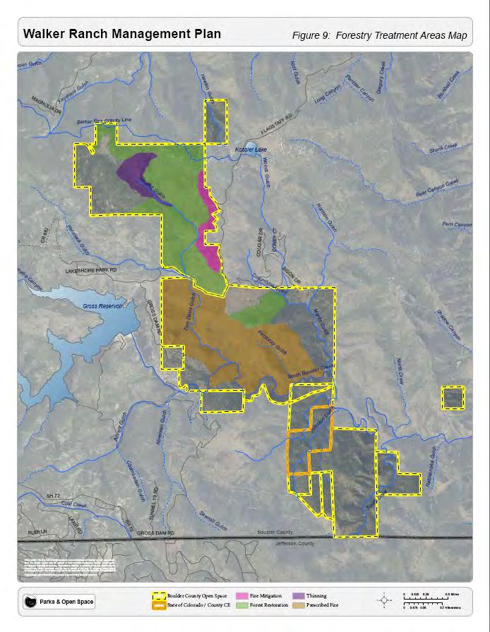
51 Page 51
52 2.6 CULTURAL RESOURCES There is significant evidence that the resources of Walker Ranch have been valued by human visitors from prehistory into the present. Prior to European visitation and settlement of Colorado, the lower elevations of the Rocky Mountains provided hunting and fishing grounds for Native Americans. Settlers variously attempted to mine and ranch the landscape of Walker Ranch. While many visitors to Walker Ranch come to enjoy the ecological and recreational bounty of the Open Space, the cultural resources can also be enjoyed through both casual visits and formal interpretive programs and events at historic sites within the Open Space. Interpretation of these resources should continue in order to connect us to the past along the Front Range CULTURAL RESOURCE SURVEYS Six cultural resource surveys have been completed in the Walker Ranch management plan area to document the historic and prehistoric resources on the properties. On the Walker Ranch property, Gordon and Kranzush, Inc. completed two surveys in 1979 and 1980 totaling over 1,600 acres, followed by the 1987 Engineering-Science Inc. survey of an additional 500 acres. After the September 2000 Eldora Springs fire that burned a portion of Walker Ranch, Native Cultural Resources completed a cultural resource survey in 2001 to investigate the burn area to determine the effects of the fire on cultural resources. On the BLM South properties, Native Cultural Resources completed a 1,132 acre cultural resource survey in 1988 as a prerequisite to the County s purchase of 25 tracts of land from the Bureau of Land Management. On the Hawkins Gulch property the Bureau of Land Management completed an 80 acre cultural resource survey in 1988 in response to Boulder County s recreation and public purposes lease of the land. The Stone, Westphal and Buffalo Park properties have not been surveyed for cultural resources PREHISTORIC RESOURCES Three prehistoric resources were recorded as part of the 1979 and 1980 Gordon and Kranzush surveys. The resources include a lithic scatter site and two isolated finds comprised of a small number of chert and percussion flakes. In addition to the recorded resources listed above, interviews with the granddaughter of James Walker, Leta Daniels, two additional sites were identified, but no surface artifacts could be found during field work conducted by Gordon and Kranzush. It is likely any remaining artifacts are buried and both sites should be regarded as culturally sensitive and any ground disturbance activity avoided. Page 52
53 2.6.3 EURO AMERICAN HISTORY Walker Ranch s namesake, James Walker moved to Boulder in 1869 according to some sources (Gladden, personal communication) or in 1865 according to others (Daniels, personal communication). In 1869 he took up residence in a lean-to in Meyer s Gulch and worked as a farmhand and share-farmer in the summer and as a carpenter in Boulder in the winter. Walker married Phoebe Fidelia Skinner in 1876 and filed a homestead claim in the Walker Ranch Area in William Ely Walker was born in March of 1877 but due to physical damage suffered while giving birth, William and Fidelia lived most of the ensuing years in Boulder. James continued to work Walker Ranch, but in the winter stayed with his family in Boulder. A permanent ranch house was completed in 1882 and became the permanent residence of the Walker family in After purchasing the Martin homestead in 1884 for $700, the Walkers continued to expand their operation. By 1885, the Walkers had 150 acres of hay, 50 head of milk cows, and 40 head of beef cattle. James Walker sold and leased portions of the ranch in 1901 to pay off debts from medical bills and failed business ventures. In 1902, Walker sold the entirety of the ranch to John J. Harris for $55,000. However, Harris failed to make all the payments and the property reverted to the Walkers. In 1894 a mining interest offered James $100,000 for the mineral contact for Walker Ranch. The first installment of that price allowed the Walkers to pay off their debts and introduce Gallaway cattle to the property. The Langridge cyanide mill opened in 1907 but closed just 7 years later. After the death of both Fidelia (in 1912) and James (1922), Walker Ranch passed down within the Walker family until it was sold in 1959 to Dr. Oliver Taylor. Dr. Taylor subdivided the property and sold the majority of it on to Mountain Valley Associates. In 1977, Boulder County purchased that property from Mountain Valley Associates HISTORIC RESOURCES The historic record of Walker Ranch can be found in the buildings, structures, and historic archaeology sites spread across the Open Space. The cultural resource surveys have recorded 45 resources that document the homesteading, ranching, mining, logging and railroad history on the property. The most visible reminder of the properties ranching history is the homestead complex. Located in an open meadow above Columbine Gulch, the complex consists of 12 buildings and structures documenting the progression the Walker s occupation on the land from homestead to large ranch operation. After BCPOS acquired Walker Ranch, the staff worked to first stabilize and then preserve the buildings and structures within the homestead complex Preservation work started in 1984 with the replacement of the Walker Cabin sill logs. Major work ended in 2012 with the construction of a garage in the homestead complex on the site of the original wood shed. While not a reconstruction, the new garage was built to meet the caretaker s needs and its exterior appearance is sensitive to the homestead complex historic nature. Page 53
54 The homestead complex was closed to the public at the beginning of the work to protect the buildings from any vandalism and the public from the unsafe conditions that existed at this time. With preservation work complete, the value of the work along with continuing safety concerns, mean that the complex remains closed to the public accept for special events. All work on the property has and will continue to follow the Secretary of the Interior s Standards for the Treatment of Historic Properties. The adoption of these standards contributed to the success of preserving the historic resources as well as consulting with historic preservation experts inside and outside Boulder County government. Skilled BCPOS craftsmen trained in historic preservation techniques complete the work and are dedicated to retaining the historic character of the property. 2,566 acres of the Walker Ranch property is listed in the National Historic Register of Historic Places and the Colorado State Register of Historic Properties for its cultural manifestations and the land representing a chapter in the history of the settlement and expansion of Boulder County and the eastern foothills of the Rocky Mountains CULTURAL RESOURCE IMPORTANCE The cultural resources at Walker Ranch are important for their contributions to our understanding of the past and for the potential to yield important information. Their value is immeasurable and their loss is irreparable. BCPOS staff has preserved all of the major historic buildings and structures in order to maintain their historic physical integrity. In most cases, cultural resource sites related to European settlement and James Walker s homesteading of the property have been signed to warn about the danger of approaching these resources. Prehistoric resource locations are not identified in order to protect the integrity of the site and the artifacts contained therein. 2.7 CULTURAL RESOURCE MANAGEMENT DIRECTION Two thousand five hundred sixty six acres of the Walker Ranch property are listed in the National Historic Register of Historic Places and the Colorado State Register of Historic Properties. This designation guides many of the management decisions related to the Walker Ranch buildings, structures, landscape, and all of the archaeology resources found on the property. The incredible educational and cultural value of this site requires constant re-evaluation, protection and maintenance. This section focuses on both protecting cultural resources and improving the interpretation of discovered and undiscovered resources at Walker Ranch. The buildings and structures at Walker Ranch help to tell the story of the early Euro American history of Boulder County, and the western United States. The buildings from the homestead complex to the remnants of mining, milling and lumber operations throughout the property create a strong link to the past. The rural landscape of the property is without intrusions and represents a continuum of land use important to the understanding of cultural patterns in the region. Preserving and interpreting these visual reminders is an important part of the management of Walker Ranch. Page 54
55 There is much more to the history of Walker Ranch than the buildings and structures themselves. There is evidence that this part of Boulder County was home, at least from time to time, to Native Americans long before European settlement. It is clear that identifying and protecting these resources is important to the community. Cultural Resource management at Walker Ranch will focus on: 1. The site around the homestead should be closed to public access except during departmentsponsored tours and events. (Figure 8: Protected Areas) 2. Maintain buildings and structures according to the Secretary of the Interior s Standards for the Treatment of Historic Properties. 3. The surrounding landscape should be maintained to minimize the negative impacts of fire and promote historic context for which the property is significant. 4. Re-evaluate buildings and structure for treatment options. 5. Assess interpretation value and develop a plan if interpretation is determined to be viable. 6. Complete cultural resource surveys for previously un-surveyed properties and conduct a reevaluation of all previously surveyed cultural resources. 7. Develop a strategy to protect and assess interpretation value. 8. Increase cultural resources staff participation with future property development. 2.8 RECREATION OPPORTUNITIES AND VISITOR USE Most visitors to Walker Ranch come for recreation and to enjoy the natural surroundings. The variety of trail experiences, historic resources, and varied ecosystems provide a wealth of opportunities to enjoy Walker Ranch. This section will cover the different recreational opportunities and facilities available to visitors AREA CHARACTER The three areas within Walker Ranch have taken on specific characters. While this was not planned, it has become habit for many users and many of the management strategies in this plan come from visitors use patterns. However, it is important to note that this area character does not directly preclude alternative uses unless specifically noted in the management direction VISITOR SERVICES AND FACILITIES Visitor Safety Walker Ranch is one of five parks within the Boulder County system that have resident rangers on-site. While the ranger at Walker is not solely responsible for maintaining the park and managing visitor safety, having a ranger on site does improve responsiveness. The resident ranger lives at the Walker Ranch Homestead and is responsible for regular patrols and for upkeep within the park. Outside of the time that the ranger is tasked with patrolling the park, it is patrolled by other Boulder County Parks and Open Space rangers and Boulder County park deputies. Page 55
56 Facilities In order to clearly delineate the facilities available at Walker Ranch, this section will be divided into the three sections of the park (Figure 9: Existing Facilities) Meyer s Gulch: Trailheads: There is one trailhead at Meyer s Gulch. The Meyer s Gulch Trailhead is located along Flagstaff Road south of the Boy Scout camp. The trailhead has upper and lower parking areas, a trail kiosk, an adjacent picnic shelter, and limited trailer parking. Trails: There are two trails on the Meyer s Gulch section of Walker Ranch. The 2.6 mile Meyer s Homestead Trail follows a fire road from the trailhead to a viewpoint at the northwest edge of the Walker Ranch property. The trail is multi-use and is heavily used for hiking, walking, equestrian use, and easy mountain biking. The second trail on Meyer s Gulch connects the Meyer s Gulch trailhead with the Walker Loop trailhead on the Central Ranch portion of the property. This trail is also multi-use and includes interpretive signage describing the impact and importance of fire on the landscape at Walker Ranch. Buildings: A small barn is located just west of the Meyer s Gulch Trail along Fire Road 2. The barn is not open to the public to protect visitors and the historic resources. Fire Roads: There are a number of fire roads on Meyer s Gulch. These roads, apart from Fire Road 1, are considered off-trail. Fire Road 1 is the Meyer s Gulch Trail. Fire Roads 2, 3, 4, and 5 intersect with Fire Road 1 and are at various levels of maintenance Central Ranch: Trailheads: There are two trailheads on the Central Ranch. The Walker Loop Trailhead has 30 parking spaces, a bathroom, an informational kiosk and a small picnic shelter. The trailhead is located off of Flagstaff Road just south of the gate to the Walker Ranch homestead. The Ethel Harrold Trailhead is located on the northeastern corner of the Central Ranch area of the Open Space. It contains 12 parking spaces, a restroom, picnic tables, and an informational kiosk. The Ethel Harrold trailhead is located off of Bison Drive. Trails: There is one trail on the Central Ranch section of the property. The Walker Loop Trail is a 7.8 mile loop that circles the property crossing onto a portion of Eldorado Canyon State Park called Crescent Meadows for approximately 1 mile. The trail is multi-use and is used for hiking, walking, equestrian use Page 56
57 Figure 10: Walker Ranch Existing Facilities Page 57
58 and advanced mountain bikers, who make up the majority of users of this trail. There is a section of stairs that discourages equestrian use due to the steepness of the section and the use of narrow and short stairs. Buildings and Structures: The Central Ranch contains the Walker Ranch homestead and associated buildings and structures. This complex has been restored and will continue to be preserved as part of the historic landscape. There are a number of small outbuildings spread across the Central Ranch. These are not open to the public for safety reasons. Fire Roads: There are two fire roads on the Central Ranch section of the property. The eastern fire road is also a service road for an existing gas pipeline. The second fire road includes the section of the Walker Loop trail that descends north from the Crescent Meadows area of Eldorado Canyon State Park South BLM The South BLM properties are located to the southeast of the rest of Walker Ranch Open Space. While the BLM South properties are designated as open to the public as of 2012, there is no legal access route to the properties except across the State Park property. Therefore, there are no public facilities on the property. 2.9 TRAILS AND FACILITIES MANAGEMENT DIRECTION Most visitors to Walker Ranch will experience the park through its trails and facilities. With three trailheads, two major trails, two connector trails, and various picnic areas and benches; Walker Ranch has a lot to offer visitors. This management plan proposes to carry forward the existing recreational features at Walker Ranch while adding some features to enhance the experience and make Walker a part of the larger recreational landscape in Boulder County (Figure 11: Proposed Facilities) TRAILS The trail system is extensive at Walker Ranch and based on surveys of park visitors and adjacent landowners, this plan does not call for a significant expansion of the existing trails. In order to address significant erosion and trail tread issues, reroutes on the Walker Loop are planned for the near term. Reroutes will be carried out through a process of consultation between the Recreation and Facilities team and the Resource Management team. Many of these reroutes will involve volunteer groups and routing may be done in consultation with these volunteer groups in limited circumstances and only after staff approval. Trail realignments are intended to address maintenance concerns and resource damage. Realignments should be carefully planned to maintain the current level of difficulty on the Walker Loop. The Meyer s Homestead trail tread will be repaired in order to upgrade the road surface for maintenance and resource management such as forestry. The repair of the Meyer s Homestead trail surface may have an impact on access for a short period of time, but the work will result in a smoother tread and improved drainage which will increase the trails longevity and reduce the impact of erosion on Meyer s and Tom Davis Gulch. Page 58

59 Figure 11: Proposed Facilities Page 59
The Chu property is a 6.57 acre parcel located in the Town of Superior on the west side of McCaslin Boulevard. In 2014, the Town of Superior acquired
 1 The Chu property is a 6.57 acre parcel located in the Town of Superior on the west side of McCaslin Boulevard. In 2014, the Town of Superior acquired the Chu property for open space with a contribution
EXECUTIVE SUMMARY PROGRAM DEVELOPMENT REPORT PURPOSE EXISTING SETTING EXPANDING PARKLAND
 EXECUTIVE SUMMARY PROGRAM DEVELOPMENT REPORT PURPOSE As the culmination of the first phase of the master planning process, this Program Development Report creates the framework to develop the Calero County
MASTER PLAN EXECUTIVE SUMMARY
 Biscuit Run State Park Scottsville Road (State Route 20) Charlottesville, VA 22902 Biscuit Run State Park MASTER PLAN EXECUTIVE SUMMARY Department of Conservation and Recreation Division of Planning and
City of Durango 5.8 FUNDING TRAILS DEVELOPMENT
 5.8 FUNDING TRAILS DEVELOPMENT The City has been successful in establishing dedicated local funding sources as well as applying for grants to develop the City s trail system, having received nearly $2.4
April 10, Mark Stiles San Juan Public Lands Center Manager 15 Burnett Court Durango, CO Dear Mark,
 Mark Stiles San Juan Public Lands Center Manager 15 Burnett Court Durango, CO 81301 Dear Mark, We are pleased to offer the following comments on the draft San Juan Public Lands Center management plans
FINAL TESTIMONY 1 COMMITTEE ON RESOURCES UNITED STATES HOUSE OF REPRESENTATIVES. July 13, 2005 CONCERNING. Motorized Recreational Use of Federal Lands
 FINAL TESTIMONY 1 STATEMENT OF DALE BOSWORTH CHIEF Of the FOREST SERVICE UNITED STATES DEPARTMENT OF AGRICULTURE Before the SUBCOMMITTEE ON FORESTS AND FOREST HEALTH And the SUBCOMMITTEE ON NATIONAL PARKS,
ROAD AND TRAIL PROJECT APPROVAL
 ROAD AND TRAIL PROJECT APPROVAL www.marincountyparks.org Marin County Parks, 3501 Civic Center Dr, Suite 260, San Rafael, CA 94903 DATE: July 12, 2017 PRESERVE: Gary Giacomini Open Space Preserve PROJECT:
MANAGEMENT DIRECTION STATEMENT June, 1999
 Thompson River District MANAGEMENT DIRECTION STATEMENT June, 1999 for Roche Lake Provincial Park Ministry of Environment Lands and Parks BC Parks Division Table of Contents I. Introduction A. Setting
Steps in the Management Planning Process
 Steps in the Management Planning Process Developing a management plan for Kalamalka Lake Park will follow a multi-stage process. The planning process for this park is currently in the Draft Management
Sibley LUPA. Board Executive Committee Meeting December 7, 2017
 Sibley LUPA Board Executive Committee Meeting December 7, 2017 Project Location & Project Area 1,318-acre Robert Sibley Volcanic Regional Preserve Project Area Purpose Project Purpose & Goals Append the
Decision Memo for Desolation Trail: Mill D to Desolation Lake Trail Relocation
 for Salt Lake County, Utah Uinta-Wasatch-Cache National Forest Salt Lake Ranger District 1. Background The present location of the Desolation Trail (#1159) between Mill D and Desolation Lake follows old
KANANASKIS COUNTRY PROVINCIAL RECREATION AREAS MANAGEMENT PLAN DRAFT TERMS OF REFERENCE - November 20, 2007
 KANANASKIS COUNTRY PROVINCIAL RECREATION AREAS MANAGEMENT PLAN DRAFT TERMS OF REFERENCE - November 20, 2007 BACKGROUND There are 42 Provincial Recreation Areas (PRAs) within Kananaskis Country located
BUCK POINT RANCH. Aspen Associates Realty
 BUCK POINT RANCH Aspen Associates Realty www.aspenassociatesrealty.com 970.544.5800 WELCOME TO Buck Point Ranch is a 960± acre property located in one of the last pristine valleys in close proximity to
2.0 PARK VISION AND ROLES
 2.0 PARK VISION AND ROLES 2.1 Significance in the Protected Area System Marble Range and Edge Hills provincial parks protect 6.8% of the Pavillion Ranges Ecosection, which is located in the Southern Interior
Map 1.1 Wenatchee Watershed Land Ownership
 Map 1.1 Wenatchee Watershed Land Ownership Map 1.1 Wenatchee Watershed Land Ownership The Wenatchee watershed lies in the heart of Washington state in Chelan County. Just larger than the state of Rhode
Preferred Recreation Recommendations Stemilt-Squilchuck Recreation Plan March 2018
 Preferred Recreation Recommendations Stemilt-Squilchuck Recreation Plan March 2018 Below are the recommended recreation ideas and strategies that package together the various recreation concepts compiled
Classifications, Inventory and Level of Service
 Classifications, Inventory and Level of Service Section 3 Kenmore Park, Recreation and Open Space Plan 1 P a g e Classifications and Inventory Park Classifications Kenmore classifies its parks based upon
Rogue River Access and Management Plan Draft Alternatives
 Rogue River Access and Management Plan Draft Alternatives The Rogue River Access and Management Plan was initiated in December, 2011 and is being led by Jackson County Parks (JCP) and Oregon Department
FOURMILE CANYON CREEK PARK Management Plan
 ~J ~l I),.:t '" FOURMILE CANYON CREEK PARK Management Plan LOCATION AND ACCESS Fourmile Canyon Creek Park is located west of Bow Mountain Subdivision. Access to the area is via Pinto Drive in the Bow Mountain
White Mountain National Forest Saco Ranger District
 United States Department of Agriculture Forest Service White Mountain National Forest Saco Ranger District 33 Kancamagus Highway Conway, NH 03818 Comm: (603) 447-5448 TTY: (603) 447-3121 File Code: 1950
Nov. 19 th Public Workshop Summary
 On November 19 th, more than 60 community members attended an Open Space Matters workshop at the Linen Building in downtown Boise for over two hours. Participants learned about reserves, discussed the
Welcome to the future of Terwillegar Park a Unique Natural Park
 Welcome to the future of Terwillegar Park a Unique Natural Park 1 Introduction The Terwillegar Park Concept Plan study will develop an overall concept plan, management objectives and development guidelines
Brinker Creek Ranch. Colorado - Routt County - Yampa
 Located at the base of the Flattops Range in the Steamboat/Vail corridor, Brinker Creek Ranch consists of 1,451 acres ideally suited for high country grazing and native grass hay production. Traditionally
HIGH COUNTRY L-BAR RANCH
 HIGH COUNTRY L-BAR RANCH Sandoval and mckinley counties N e w m e x i c o Jim Haworth, Ranch Team Lead Broker ~ 505-235-5236 3613 NMSR 528 NW, Ste. H, Albuquerque, NM 87114 505-792-3713 www.wwrealty.com
Welcome and thank you for being here! Kick-Off Public Workshop November 19, 2014
 Welcome and thank you for being here! Kick-Off Public Workshop November 19, 2014 OPEN SPACE MATTERS: Boise s First Reserve Master Plan Julia Grant Foothills and Open Space Manager City of Boise Ellen Campfield
MONTEREY REGIONAL AIRPORT MASTER PLAN TOPICAL QUESTIONS FROM THE PLANNING ADVISORY COMMITTEE AND TOPICAL RESPONSES
 MONTEREY REGIONAL AIRPORT MASTER PLAN TOPICAL QUESTIONS FROM THE PLANNING ADVISORY COMMITTEE AND TOPICAL RESPONSES Recurring topics emerged in some of the comments and questions raised by members of the
(Short Listing) DUPUYER ACREAGE, ROCKY MOUNTAN FRONT
 DUPUYER ACREAGE, ROCKY MOUNTAN FRONT") (Short Listing) DUPUYER ACREAGE, ROCKY MOUNTAN FRONT This unique property is located 8½ miles northwest of Dupuyer, Montana and approximately thirty 30 miles northwest of Choteau, Montana. Great Falls
(Short Listing) DUPUYER ACREAGE, ROCKY MOUNTAN FRONT This unique property is located 8½ miles northwest of Dupuyer, Montana and approximately thirty 30 miles northwest of Choteau, Montana. Great Falls
Longmont to Boulder Regional Trail Jay Road Connection DRAFT FINAL REPORT
 Longmont to Boulder Regional Trail Jay Road Connection DRAFT FINAL REPORT December 2018 Project Summary Boulder County, Colorado, in partnership with the City of Boulder, is evaluating options for multi-use
Rule Governing the Designation and Establishment of All-Terrain Vehicle Use Trails on State Land
 Rule Governing the Designation and Establishment of All-Terrain Vehicle Use Trails on State Land 1.0 Authority 1.1 This rule is promulgated pursuant to 23 V.S.A. 3506. Section 3506 (b)(4) states that an
Criddle/Vane Homestead Provincial Park. Management Plan
 Criddle/Vane Homestead Provincial Park Management Plan 2 Criddle/Vane Homestead Provincial Park Table of Contents 1. Introduction... 3 2. Park History.... 3 3. Park Attributes.... 4 3.1 Natural.... 4 3.2
Region 1 Piney Woods
 Region 1 Piney Woods Piney Woods 1. This ecoregion is found in East Texas. 2. Climate: average annual rainfall of 36 to 50 inches is fairly uniformly distributed throughout the year, and humidity and temperatures
RECREATION. Seven issues were identified that pertain to the effects of travel management on outdoor recreation within portions of the project area.
 RECREATION Seven issues were identified that pertain to the effects of travel management on outdoor recreation within portions of the project area. OPPORTUNITIES FOR SOLITUDE / QUIET TRAILS. One attraction
Northeast Quadrant Distinctive Features
 NORTHEAST QUADRANT Northeast Quadrant Distinctive Features LAND USE The Northeast Quadrant includes all the area within the planning area that is east of Interstate 5 and to the north of State Route 44.
CRAZY HORSE TRAIL GUIDE
 CRAZY HORSE TRAIL GUIDE Abridged Version: July 2016 This is a short form of our interpretive trail guide for the Crazy Horse Trail. The full version of the guide has a more detailed description of the
1803 West Hwy 160 Monte Vista, CO (719) TTY (719)
 TTY (719)") USDA Forest Service Rio Grande National Forest http://www.fs.fed.us/r2/riogrande 1803 West Hwy 160 Monte Vista, CO 81144 (719)852-5941 TTY (719)852-6271 USDI Bureau of Land Management San Luis Valley Center
USDA Forest Service Rio Grande National Forest http://www.fs.fed.us/r2/riogrande 1803 West Hwy 160 Monte Vista, CO 81144 (719)852-5941 TTY (719)852-6271 USDI Bureau of Land Management San Luis Valley Center
Chapter 2: El Dorado County Characteristics and Demographics
 Chapter 2: El Dorado County Characteristics and Demographics 2.1 Geographic Area and Demographics El Dorado County comprises 1,805 square miles with over half of the area in the Eldorado National Forest
2.0 Physical Characteristics
 _ 2.0 Physical Characteristics 2.1 Existing Land Use for the Project The site is comprised of approximately 114 acres bounded by Highway 101 to the north, the existing town of Los Alamos to the east, State
Logo Department Name Agency Organization Organization Address Information 5700 North Sabino Canyon Road
 Logo Department Name Agency Organization Organization Address Information United States Forest Coronado National Forest 5700 North Sabino Canyon Road Department of Service Santa Catalina Ranger District
CHAPTER III: TRAIL DESIGN STANDARDS, SPECIFICATIONS & PERMITS
 CHAPTER III Trail Design Standards, Specifications & Permits This chapter discusses trail standards, preferred surface types for different activities, permits, and other requirements one must consider
Marchand Provincial Park. Management Plan
 Marchand Provincial Park Management Plan 2 Marchand Provincial Park Table of Contents 1. Introduction... 3 2. Park History... 3 3. Park Attributes... 4 3.1 Natural... 4 3.2 Recreational... 4 3.3 Additional
Open Space and Mountain Parks (OSMP) Department
 Department") Open Space and Mountain Parks (OSMP) Department Marshall Mesa-Southern Grasslands Trail Study Area (TSA) Plan November 4, 2005 1 Open Space and Mountain Parks (OSMP) Department Marshall Mesa-Southern Grasslands
Open Space and Mountain Parks (OSMP) Department Marshall Mesa-Southern Grasslands Trail Study Area (TSA) Plan November 4, 2005 1 Open Space and Mountain Parks (OSMP) Department Marshall Mesa-Southern Grasslands
Connie Rudd Superintendent, Black Canyon of the Gunnison National Park
 National Park Service U.S. Department of the Interior Black Canyon of the Gunnison National Park and Curecanti National Recreation Area Information Brochure #1 Wilderness and Backcountry Management Plan
Pillar Park. Management Plan
 Pillar Park Management Plan January 2014 Pillar Park Management Plan Approved by: Jeff Leahy Regional Director Thompson Cariboo Region BC Parks January 9, 2014 Date Brian Bawtinheimer Executive Director
PROPOSED ACTION South 3000 East Salt Lake City, UT United States Department of Agriculture
 United States Department of Agriculture Forest Service Uinta-Wasatch-Cache National Forest Salt Lake Ranger District 6944 South 3000 East Salt Lake City, UT 84121 801-733-2660 File Code: 1950/2300 Date:
Conservation Area Management Statement
 Conservation Area Management Statement Miller Creek Wildlife Area Resolution #: Approval: Issue Date: Date of Last Revision: Table of Contents 1. Purpose....... 1 2. Property Description...... 1 2.1. Legal
Establishing a National Urban Park in the Rouge Valley
 STAFF REPORT ACTION REQUIRED Establishing a National Urban Park in the Rouge Valley Date: March 29, 2012 To: From: Wards: Reference Number: Executive Committee Deputy City Manager, Cluster B All p:\2012\cluster
David Johnson. Tom, Attached please find the final scoping letter and figures for your review. David
 David Johnson From: Sent: To: Cc: Subject: Attachments: David Johnson Tuesday, April 12, 2011 4:33 PM Thomas Malecek Dave Dyer; Jason Marks (jmarks@segroup.com) VWC Scoping Letter
Sawtooth National Forest Fairfield Ranger District
 United States Department of Agriculture Forest Service Sawtooth National Forest Fairfield Ranger District P.O. Box 189 Fairfield, ID. 83327 208-764-3202 Fax: 208-764-3211 File Code: 1950/7700 Date: December
January 14, Orange County Transportation Authority Attn: M2 NCCP/HCP 550 South Main Street P.O. Box Orange, CA
 Equestrian Trails, Inc. Corral 357 P.O. Box 1026 Trabuco Canyon, CA 92678 http://saddlebackcanyonriders.com/ President: James Iacono... 714-612-1789 January 14, 2016 Orange County Transportation Authority
Wilderness Areas Designated by the White Pine County bill
 Wilderness Areas Designated by the White Pine County bill SEC. 321. SHORT TITLE. This subtitle may be cited as the `Pam White Wilderness Act of 2006'. SEC. 322. FINDINGS. Congress finds that-- The White
What Is An Ecoregion?
 Ecoregions of Texas What Is An Ecoregion? Ecoregion a major ecosystem with distinctive geography, characteristic plants and animals, and ecosystems that receives uniform solar radiation and moisture Sometimes
Terrestrial Protected Area Nomination: Central Mangrove Wetland South-West, Grand Cayman
 Terrestrial Protected Area Nomination: Central Mangrove Wetland South-West, Grand Cayman The attached nomination, proposing that a parcel of land in the Central Mangrove Wetland be made a Protected Area
Dixon Trail Construction - From the Top of the Mountain 2016 Interim Report Friends of Cheyenne Mountain State Park September 2 nd, 2016
 - Dixon Trail Construction - From the Top of the Mountain 2016 Interim Report Friends of Cheyenne Mountain State Park September 2 nd, 2016 Prepared by: Andy Riter, Program Coordinator, and Joe Lavorini,
2. Goals and Policies. The following are the adopted Parks and Trails Goals for Stillwater Township:
 D. PARKS AND TRAILS 1. Introduction Stillwater Township s population is relatively low, with most residents living on rural residences on large lots. The need for active park space has been minimal in
Blueways: Rivers, lakes, or streams with public access for recreation that includes fishing, nature observation, and opportunities for boating.
 Parks, Open Space and Trails PRINCE WILLIAM COUNTY 2008 COMPREHENSIVE PLAN TRAILS PLAN CONTENTS The components of the trails plan are: Intent Definitions Goals, Policies, and Action Strategies Trails Map
Whitemouth Falls Provincial Park. Draft Management Plan
 Whitemouth Falls Provincial Park Draft Management Plan Whitemouth Falls Provincial Park Draft Management Plan Table of Contents 1. Introduction... 3 2. Park History... 3 3. Park Attributes... 4 3.1 Natural...
MANAGEMENT DIRECTION STATEMENT June, 1999
 Thompson River District MANAGEMENT DIRECTION STATEMENT June, 1999 for Clearwater River Corridor (Addition to Wells Gray Park) Ministry of Environment Lands and Parks BC Parks Division ii Table of Contents
Wallace Lake Provincial Park. Management Plan
 Wallace Lake Provincial Park Management Plan 2 Wallace Lake Provincial Park Table of Contents 1. Introduction... 3 2. Park History... 3 3. Park Attributes... 4 3.1 Natural... 4 3.2 Recreational... 4 4.
ANAGEMENT. LAN November, 1996
 M ANAGEMENT P LAN November, 1996 for Paul Lake Provincial Park Ministry of Environment, Lands and Parks BC Parks Department Paul Lake Provincial Park M ANAGEMENT P LAN Prepared by BC Parks Kamloops Area
TAYLOR CANYON RANCH COLORADO - ROUTT COUNTY - STEAMBOAT SPRINGS
 TAYLOR CANYON RANCH COLORADO - ROUTT COUNTY - STEAMBOAT SPRINGS Tucked up against the steep valley shaped by Mt. Pau and rising to the Routt National Forest, Taylor Canyon Ranch is an easily accessible,
Proposed Action. Payette National Forest Over-Snow Grooming in Valley, Adams and Idaho Counties. United States Department of Agriculture
 United States Department of Agriculture Forest Service January 2012 Proposed Action Payette National Forest Over-Snow Grooming in Valley, Adams and Idaho Counties Payette National Forest Valley, Adams
Summary of prescribed fires in Prince Albert National Park 2015
 Summary of prescribed fires in Prince Albert National Park 2015 Prince Albert National Park conducted four controlled fires in spring 2015, plus an additional fire in October. Fuel Management for Hazard
Biosphere Reserves of India : Complete Study Notes
 Biosphere Reserves of India : Complete Study Notes Author : Oliveboard Date : April 7, 2017 Biosphere reserves of India form an important topic for the UPSC CSE preparation. This blog post covers all important
Colorado Life Zone Scavenger Hunt
 Colorado Life Zone Scavenger Hunt Below are worksheets created for all the habitats or life zones. They were designed with the intention of breaking the class up into small groups, and having students
3.0 EXISTING PARK & RECREATION SPACE
 3.0 EXISTING PARK & RECREATION SPACE TOWN PARK & RECREATION SPACE An inventory of current parks and recreation area in the Town of Cedarburg is shown in Table 3. These areas total roughly 381.89 acres.
Hartsel Springs Ranch 4,637 Acres Park County, Colorado $4,780,000
 Hartsel Springs Ranch 4,637 Acres Park County, Colorado $4,780,000 Presented By: Farm, Ranch & Recreational Real Estate Hartsel Springs Ranch 4,637 Acres Park County, Colorado $4,780,000 Property Description
Proposed Official Plan Amendment 41 to the Region of York Official Plan
 COMMITTEE OF THE WHOLE NOVEMBER 18, 2002 REGION OF YORK OFFICIAL PLAN AMENDMENT 41 THE OAK RIDGES MORAINE CONSERVATION PLAN Recommendation The Commissioner of Planning recommends: 1. That the City of Vaughan
Numaykoos Lake Provincial Park. Management Plan
 Numaykoos Lake Provincial Park Management Plan 2 Numaykoos Lake Provincial Park Table of Contents 1. Introduction... 3 2. Background... 3 3. Park Purpose... 5 4. Park Management Guidelines... 6 Appendix...
Decision Memo Broken Wheel Ranch Equestrian Outfitter Special-Use Permit Proposed Action
 Decision Memo Broken Wheel Ranch Equestrian Outfitter Special-Use Permit USDA Forest Service Mississippi Bluffs Ranger District, Shawnee National Forest Jackson and Union Counties, Illinois Proposed Action
Chapter 8: Colorado Plateau State Highway 141, Dove Creek to Naturita
 State Highway 141 Dove Creek to (61 miles) Summary: Highway 141 heads north from US Highway 491 about two miles northwest of the town of Dove Creek. Initially, the highway runs through gently rolling farming
SHASTA WEST PLANNING AREA
 2016 SHASTA COUNTY COMMUNITY WILDFIRE PROTECTION PLAN SHASTA WEST PLANNING AREA Covering the communities of: Centerville Redding (west & downtown) Shasta I. PROPOSED PROJECTS A. THE PLANNING AREA SHASTA
PROPOSED PARK ALTERNATIVES
 8 Chimne y Rock State Park M a ster Pl an 2011 PROPOSED PARK ALTERNATIVES Introduction Three different park development concepts were prepared and presented to the citizens of North Carolina through a
Blanco Creek Ranch Acres, Uvalde County, Texas
 Blanco Creek Ranch 1208.30 Acres, Uvalde County, Texas James King, Agent Office 432 426.2024 Cell 432 386.2821 James@KingLandWater.com Blanco Creek Ranch 1208.30 acres Uvalde County, Texas James King,
MANAGEMENT DIRECTION STATEMENT
 Lower Mainland District MAAGEMET DIRECTIO STATEMET January 2001 for Liumchen Ecological Reserve Ministry of Environment Lands and Parks BC Parks Division Table of Contents Page Introduction... 1 Purpose
Dungeness Recreation Area County Park Master Plan
 Dungeness Recreation Area County Park Public Outreach Meeting October 10, 2007 Project Overview USFWS Site Dungeness Recreation Area County Park Meeting Objectives: Re-Introduce project; provide status
URBAN DESIGN REPORT. Proposed Residential Development, Old Church Road, Caledon East
 Proposed Residential Development, Old Church Road, Caledon East TABLE CONTENTS: 1.0 DEVELOPMENT 1.1 Introduction-Analysis of Guiding Principles and Documents 1.2 Community Design and Architectural Design
APPENDIX OFFICIAL MAP ORDINANCE OF HAMILTONBAN TOWNSHIP OFFICIAL MAP NARRATIVE
 APPENDIX A OFFICIAL MAP ORDINANCE OF HAMILTONBAN TOWNSHIP OFFICIAL MAP NARRATIVE INTRODUCTION: The Official Map of Hamiltonban Township has been prepared to identify those lands and features that Hamiltonban
The following criteria were used to identify Benchmark Areas:
 7.0 BENCHMARK AREAS The Churn Creek Protected Area offers a significant opportunity to learn more about how grassland ecosystems function. One of the key tools that will be used to monitor larger grassland
13.1 REGIONAL TOURISM ISSUES AND SUMMARY OF FINDINGS
 13 REGIONAL TOURISM T he County of Mariposa s recreation needs and facilities fall within two categories: regional tourism and local recreation. This Element focuses on regional tourism issues related
Submission to NSW Koala Strategy Consultation Process. March 2017
 Submission to NSW Koala Strategy Consultation Process March 2017 Table of contents Opening 3 Response 3 Whole-of-government NSW koala strategy 3 State Environment Planning Policy (SEPP) 44 3 The draft
Fossil Creek Wild & Scenic River Comprehensive River Management Plan Forest Service Proposed Action - details March 28, 2011
 Fossil Creek Wild & Scenic River Comprehensive River Management Plan Forest Service Proposed Action - details March 28, 2011 Primary Goals of the Proposed Action 1. Maintain or enhance ORVs primarily by
Trail Phasing Plan. Note: Trails in the Clear Creek Canyon area (Segments will be finalized in the future to minimize wildlife impacts
 Note: Trails in the Clear Creek Canyon area (Segments 2 5 and a future JCOS connection) will be finalized in the future to minimize wildlife impacts Trail Phasing Plan P Parking 3 Easy Trail Intermediate
Bayview Escarpment. Interim Management Statement
 Bayview Escarpment Interim Management Statement Bayview Escarpment Provincial Nature Reserve Interim Management Statement January 15, 1995 REGIONAL DIRECTOR'S APPROVAL STATEMENT This Interim Management
METROPOLITAN COUNCIL 390 North Robert Street, St. Paul, MN Phone (651) TDD (651)
 TDD (651)") DATE: March 27, 2012 METROPOLITAN COUNCIL 390 North Robert Street, St. Paul, MN 55101 Phone (651) 602-1000 TDD (651) 291-0904 TO: Metropolitan Parks and Open Space Commission FROM: Arne Stefferud, Planning
DATE: March 27, 2012 METROPOLITAN COUNCIL 390 North Robert Street, St. Paul, MN 55101 Phone (651) 602-1000 TDD (651) 291-0904 TO: Metropolitan Parks and Open Space Commission FROM: Arne Stefferud, Planning
Attendance Presentation
 TO The Community of Saanich FROM District of Saanich DATE January 30, 2017 RE Meeting Notes Haro Woods Jan 28th Community Engagement Goward House, 2495 Arbutus Road, Victoria BC Attendance In total, 18
Criddle/Vane Homestead Provincial Park. Draft Management Plan
 Criddle/Vane Homestead Provincial Park Draft Management Plan 2 Criddle/Vane Homestead Provincial Park Table of Contents 1. Introduction... 3 2. Park History.... 3 3. Park Attributes.... 3 3.1 Natural....
26 Utah s Patchwork Parkway SCENIC BYWAY CORRIDOR MANAGEMENT PLAN (SR 143)
") Natural Natural Quality applies to those features in the visual environment that are in a relatively undisturbed state. These features predate the arrival of human populations and may include geological
Natural Natural Quality applies to those features in the visual environment that are in a relatively undisturbed state. These features predate the arrival of human populations and may include geological
Backgrounder Plains Bison Reintroduction to Banff National Park
 Backgrounder Plains Bison Reintroduction to Banff National Park Introduction The five-year reintroduction project is a small- scale initiative that would inform future decisions regarding the feasibility
Business Item No
 Metropolitan Parks and Open Space Commission Meeting date: February 6, 2018 For the Community Development Committee meeting of February 20, 2018 For the Metropolitan Council meeting of February 28, 2018
Pinellas County Environmental Lands
 Pinellas County Environmental Lands In addition to traditional parks and recreation facilities, Pinellas County owns and manages a system of environmental lands that provides specialized resource-based
As outlined in the Tatshenshini-Alsek Park Management Agreement, park management will:
 Management Strategy General Strategy The priority management focus for the park is to ensure that its internationally significant natural, cultural heritage and recreational values are protected and that
Yard Creek Provincial Park. Management Plan
 Yard Creek Provincial Park Management Plan Draft January 2010 Yard Creek Provincial Park Management Plan Approved by: telàlsemkin/siyam/chief Scott Benton Bill Williams Squamish Executive Director ation
OPEN SPACE. The Open Space Element describes the County s goals and policies with respect to open space areas and addresses the following topics:
 PURPOSE This element addresses open spaces for: the managed production of resources, outdoor recreation, public health and safety, and the preservation of natural resources. Amador County s open space
Heil Valley Ranch 2 Small Area Plan
 Heil Valley Ranch 2 Small Area Plan Table of Contents Table of Figures... 2 Introduction... 3 Purpose and Need... 3 Management Goals... 4 Planning Context... 5 Location... 5 September 2013 Flood Event...
Mackinnon Esker Ecological Reserve Draft - Management Plan
 Mackinnon Esker Ecological Reserve Draft - Management Plan May 2011 Photo Credit: This document replaces the direction provided in the Carp Lake Provincial Park and Protected Area and Mackinnon Esker Ecological
Frizzell Creek Ranch Summerville, OR $1,400, ± Acres
 Frizzell Creek Ranch Summerville, OR $1,400,000 165± Acres 1 Introduction The Frizzell Creek Ranch is a beautiful 165± acre ranch located in northeast Oregon at the base of the Wallowa Whitman National
Stagecoach State Trail Master Plan
 Stagecoach State Trail Master Plan Minnesota Minnesota Department Department of of Natural Natural Resources Resources Parks and and Trails Trails Division Division Parks March March 2012 2012 The Minnesota
10/25/2013. What is the SCORP?! 2013 Local Government Survey 2013 Statewide Public Survey Advisory Group Priority Areas Your Suggestions!
 COLORADO OUTDOOR RECREATION TRENDS RESULTS FROM THE SCORP AND STATEWIDE Colorado Outdoor Recreation Resource Partnership September 2013 PRESENTATION What is the SCORP?! 2013 Local Government Survey 2013
Geoscape Toronto The Oak Ridges Moraine Activity 2 - Page 1 of 10 Information Bulletin
 About 13,000 years ago as the Laurentide Ice Sheet melted, glacial meltwater accumulated between the ice sheet and the Niagara Escarpment. This formed a lake basin into which gravel and sand were deposited.
Kit Carson-Challenger Ridge Trail Project Annual Performance Report-2014 October 22, 2014
 1 Kit Carson-Challenger Ridge Trail Project Annual Performance Report-2014 October 22, 2014 Willow Lake and Kit Carson Peak 2 SUMMARY The Rocky Mountain Field Institute began Phase 1 of a multi-phase,