Hamilton Recreational Trails Master Plan
|
|
|
- Patience Whitehead
- 6 years ago
- Views:
Transcription


1 Hamilton Recreational Trails Master Plan DRAFT NOVEMBER 2015
2
3 TABLE OF CONTENTS Table of Contents... i-v Acknowledgments... vi 1.0 Study Introduction A History of Trails in Hamilton Trail Vision, Goals, & Objectives for the City of Hamilton The Benefi ts of Trail Development The Organization of the Master Plan Report The Trails Network Understanding what has Already Been Done: The Previous Trail Master Plan (2007) The Trail Master Plan Update Process Trails Master Plan Opportunities Guidelines for Trail Development and Route Selection Inventory of Existing Trails and Fieldwork Methodology The Proposed Trail Network a) Individual Ward Characteristics b) Existing 2007 Trail Initiatives c) Proposed 2015 Trail Initiatives Trail Design Construction Considerations How to Use the Trail Guidelines Trail Users and Needs General Trail Design Parameters Accessibility and AODA Requirements Personal Security and CPTED Trail Lighting & Trail Safety Trail Hierarchy and Surfacing Boulevard Multi-use Trails On-road Trail Connections Shared Use Lanes and Paved Shoulders Bike Lanes Trail Development in Hydro Corridors Trail Crossings Minor and Major Roads Active Railways Bridges Underpasses and Tunnels HAMILTON RECREATIONAL TRAILS MASTER PLAN DRAFT 2015 PAGE i
4 2.9 Off-Road Trail Structures Gates and Barriers Swing Gates Bollards Elevated Trailbeds and Boardwalks Switchbacks and Stairs Trail Signage Signage Strategy and Typical Branding Signage Types a) Gateway Signage b) Orientation and Trailhead Signage c) Trail Etiquette Signage d) Regulatory/Caution Signage e) Route Markers and Trail Directional Signage f) Interpretive Signage g) Urban Fitness Trails Trailheads and Trail Amenities Seating and Rest Areas Bicycle Parking Trail Closures and Rehabilitation Trails in Natural Areas and Environmental Buffers Creating New Trails in Established Neighbourhoods Lease Agreement and Land Acquisition Public Outreach and Trail Promotion Community Based Social Marketing Hamilton Trail Map, Signs, and Brochures Trail Ambassadors Partnerships The Implementation Plan How to Implement the Trails Master Plan The Trails Network Implementation Strategy Trails Interdepartmental Working Group Comprehensive Implementation Establishing Priorities and Network Phasing Outreach, Promotion, & Potential Funding Sources Managing Trails and Maintenance Expectations HAMILTON RECREATIONAL TRAILS MASTER PLAN DRAFT 2015 PAGE ii
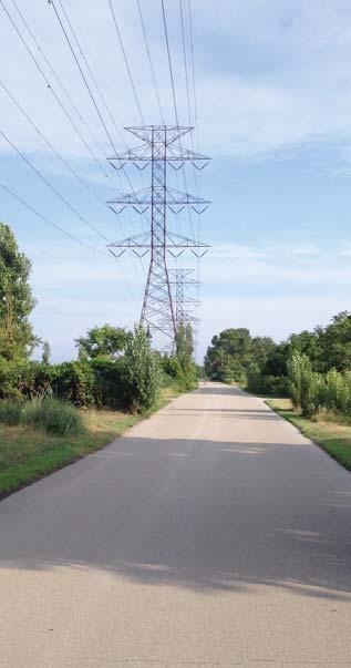
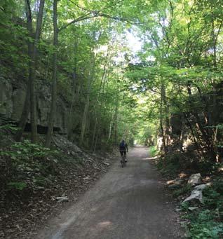
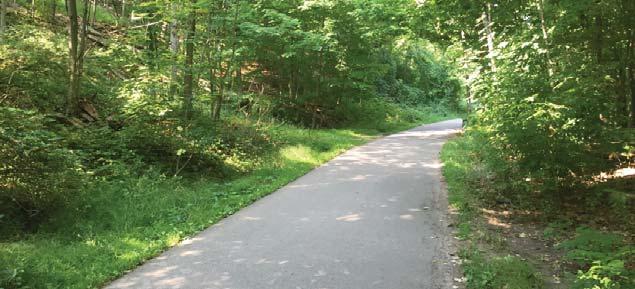
5 3.4.1 Insurance, Liability, and Risk Management Establishing a Trail Maintenance Plan Maintenance Partnerships Location and Trail Alignment Maintenance Considerations Trail Surfacing Materials Maintenance Considerations Winter Maintenance of Trails Summary of Recommendations and Next Steps Appendix A - Summary of Public Engagement Activities A.1 Public Consultation Meetings A.2 Stakeholder Consultation A.3 Online Survey Questionnaire Appendix B - Summary of Existing Policies and Plans B.1 Federal Policies and Plans B.2 Provincial Policies and Plans B.3 Federal, Provincial, and Municipal Organizations B.4 Hamilton Conservation Authority B.5 City of Hamilton List of Maps Map 1-15 Ward 1 to 15 Trail Network Maps List of Figures Figure 1 East Hamilton Waterfront Link Pedestrian Bridge (Photo credit: City of Hamilton)... Figure 2 Bayfront Park Trail (Photo credit: Seferian Design Group)... Figure 3 Having access to trails encourages an active lifestyle (Photo credit: Figure 4 Chedoke Rail Trail (Photo credit: Seferian Design Group)... Figure 5 Asphalt trail along the Chedoke Radial Trail (Photo credit: Seferian Design Group)... Figure 6 Many trails in Hamilton are routed through scenic and natural areas (Photo credit: Seferian Design Group)... Figure 7 Asphalt trail in the T.B. McQuesten Community Park (Photo credit: Seferian Design Group) Figure 8 Tunnel with lighting along the Red Hill Valley Trail under King St E, south of the Red Hill Bowl sports fi elds (Photo credit: Seferian Design Group)... Figure 9 Solar pathway lighting provides numerous environmental benefi ts (Photo credit: Figure m wide multi-use asphalt trails (Class A) in Bayfront Park (Photo credit: Seferian Design Group) Packed granular (Class B) Red Hill Valley Trail (Photo credit: Seferian Design Group) HAMILTON RECREATIONAL TRAILS MASTER PLAN DRAFT 2015 PAGE iii
6 The Bruce Trail through Hamilton is an excellent example of a natural surface trail (Class C) (Photo credit: Seferian Design Group)... Figure 11 Multi-use boulevard trail along the south side of Strachan St. W. between BaySt. N. and James St. N. (Photo credit: Seferian Design Group)... Figure 12 Multi-use boulevard trail along York Blvd. adjacent to Dundurn Park (Photo credit: Seferian Design Group)... Figure 13 Hydro corridors throughout the city provide excellent opportunities for trail development (Photo credit: Seferian Design Group)... Figure 14 Various bridge structures along the Chedoke Radial Trail (Photo credit: Seferian Design Group)... Figure 15 Trail entrance to the RBG off York Blvd. (Photo credit: Seferian Design Group)... Figure 16 Dundurn Stairs (Photo credit: Figure 17 Gateway signage at Bayfront Park (Photo credit: Seferian Design Group)... Figure 18 Chedoke Radial Trailhead signage (Photo credit: Seferian Design Group)... Figure 19 Trail etiquette signage (Photo credit: Seferian Design Group)... Figure 20 Trail etiquette signage at Bayfront Park (Photo credit: Seferian Design Group)... Figure 21 Caution signage example (Photo credit: Seferian Design Group)... Figure 22 Directional signage example at the RBG (Photo credit: Seferian Design Group)... Figure 23 Directional signage example at the Eramosa Karst Conservation Area (Photo credit: Seferian Design Group)... Figure 24 On-road directional signage (Photo credit: Seferian Design Group)... Figure 25 Interpretive signage panel in the Eramosa Karst CA (Photo credit: Seferian Design Group)... Figure 26 Fitness circuit signage (with QR codes) in T.B. McQuesten Community Park (Photo credit: Seferian Design Group)... Figure 27 QR example on Urban Fitness Trail signage (Photo credit: City of Hamilton)... Figure 28 Red Hill Valley Trailhead signage (Photo credit: Seferian Design Group)... Figure 29 Washroom facility at the Dundas Driving Park (Photo credit: Seferian Design Group)... Figure 30 Parking lot space at the Chedoke Radial Trailhead along Scenic Drive (Photo credit: Seferian Design Group)... Figure 31 Many trails throughout the city offer seating, trash receptacles, lighting, and other trail amenities (Photo credit: Seferian Design Group)... Figure 32 Trail signage can provide excellent opportunities for donor recognition and sponsorships (Photo credit: Seferian Design Group)... Figure 33 Eramosa Karst CA trail map signage (Photo credit: Seferian Design Group) HAMILTON RECREATIONAL TRAILS MASTER PLAN DRAFT 2015 PAGE iv
7 Figure 34 The City of Hamilton has numerous trail partners, including the Bruce Trail Conservancy (Photo credit: Seferian Design Group)... Figure 35 Bayfront Park trails gateway feature (Photo credit: Seferian Design Group)... Figure 36 Interpretive kiosks, like this one in the Eramosa Karst CA, are a great way to promote trails (Photo credit: Seferian Design Group)... Figure 37 Several trails within Hamilton do not offer winter maintenance (Photo credit: Seferian Design Group)... Figure 38 Bayfront Park Trails (Photo credit: Seferian Design Group)... Figure 39 Public Information Centre #1 at the Hamilton Environmental Summit (Photo credit: Seferian Design Group)... Figure 40 Public Information Centre #1 at the Hamilton Environmental Summit on April 22, 2015 (Photo credit: Seferian Design Group)... Figure 41 Let s Talk Trails! questionnaire used at the TrailHead Ontario 2015 Conference on June 7, 2015 (Photo credit: Seferian Design Group)... Figure 42 Cover page for the online survey (Photo credit: Seferian Design Group)... Figure 43 Tew s Falls (Photo credit: Figure 44 Sobi bike station at the corner of Hunter St E and Ferguson Ave S (Photo credit: Seferian Design Group) List of Tables Table 1 Public Consultation Activities Summary Chart... 8 Table 2 Summary of Individual Ward Characteristics Table 3 Summary of 2007 Trail Initiatives Table 4 Summary of 2015 Trail Initiatives Table 5 Optimal Trail User Operating Guidelines Table 6 CPTED Principles Table 7 Trail Hierarchy and Surfacing Table 8 Trail Surfacing Advantages and Disadvantages Table 9 Summary of Public Consultation Comments HAMILTON RECREATIONAL TRAILS MASTER PLAN DRAFT 2015 PAGE v
8 ACKNOWLEDGEMENTS The 2015 City of Hamilton Recreational Trails Master Plan Update project team would like to express their appreciation to the following individuals that contributed to the development of this report, as well as the many other agencies, stakeholders, and members of the public who through their input, contributed to its development. City of Hamilton Project Team Members Leila Fazel Todd, BSc, MLA Landscape Architectural Services City of Hamilton Cynthia Graham, MLA, OALA, CSLA Supervisor, Landscape Architectural Services City of Hamilton Daryl Bender Project Manager, Alternative Transportation Public Works City of Hamilton Jarrad Johnston Technician, Public Works City of Hamilton Consultant Project Team Members Brad Smith, BLA, OALA, CSLA, ASLA Senior Landscape Architect and Project Manager Seferian Design Group Carolina Schmitz, B. Arch. Landscape Designer and LEED Green Associate Seferian Design Group Jeff Bonnett, BA, Dip. Applied Arts Landscape Designer Seferian Design Group Anita Geier, BComm, DipBA, CPSI Offi ce Controller Seferian Design Group The 2015 City of Hamilton Recreational Trails Master Plan Update project team would also like to thank O Connor Mokrycke Consultants for their work and dedication to the original 2007 City of Hamilton Recreational Trails Master Plan report. HAMILTON RECREATIONAL TRAILS MASTER PLAN DRAFT 2015 PAGE
9 HAMILTON RECREATIONAL TRAILS MASTER PLAN DRAFT 2015 PAGE vii This Page is Intentionally Left Blank


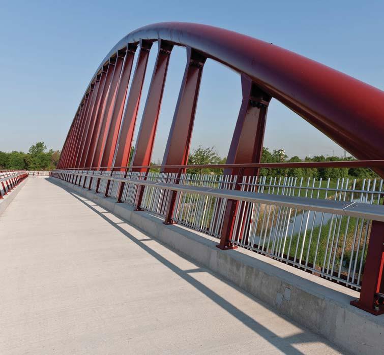
10 Figure 1: East Hamilton Waterfront Link Pedestrian Bridge 1.0 STUDY INTRODUCTION
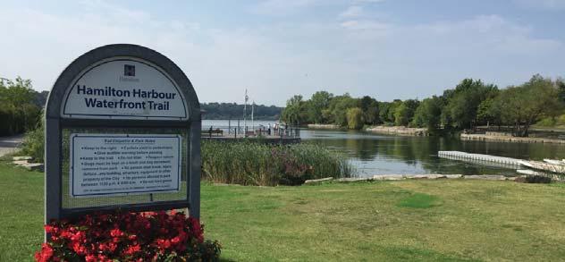
11 The public demand for high quality connected trail systems is increasing as the City of Hamilton continues to grow. Trails within the City of Hamilton facilitate city-wide travel and are an important resource in connecting parks, recreational centres, schools, commercial sites, cultural and institutional centres, transit facilities and numerous residential neighbourhoods. In 2007 the Recreational Trails Master Plan was approved by Council and since its inception has been a framework for the City for implementing the trail network. However, as the City and surrounding communities grow and new infrastructure is developed there is a need to revisit and update the Recreational Trails Master Plan. This City-wide update addresses trails and trail infrastructure and will make recommendations for new connections throughout the City, for active transportation and recreation for residents and visitors alike. The update of the Recreational Trails Master Plan was developed with the review and comments of trail users, Hamilton s trail partners and organizations, the public, government agencies and City departments. In order to guide the future development of Hamilton s trail system in a manner consistent with Federal, Provincial and Municipal legislation and policy, similar to the 2007 report, this updated Recreational Trails Master Plan aims to accomplish the following: Integrate components of the existing recreational trail system, including those planned in the 2007 report; Propose new (2015) trail initiatives and incorporate them with 2007 trail initiatives. This will help to alleviate gaps in the overall trails system; Identify new hubs where trails intercept for the purposes of facility development; Integrate new trail accesses, routes, and crossings with existing and planned City infrastructure (e.g. Highway 403, Lincoln Alexander Parkway, Red Hill Valley Parkway, waterfront, escarpment feature, GO transit stations); Improve the City s transportation system to support multi-modal mobility and encourage inter-regional connections; Strengthen partnerships with other trail organizations and groups; Continue to build upon physical, economic, sustainable, and environmental design standards; Further develop maintenance and management standards; Identify new trail facilities to provide a better user experience; Priority recommendations for implementation and development; Integrate off-road trails with the planned onroad cycling networks where possible/feasible to better address broader community land use and transportation goals and objectives. An important part of the Recreational Trails Master Plan is the creation of a connected system of trails and supportive trail infrastructure. The trail network builds upon the current routes and concepts, including previously developed trails, as well as those routes previously identifi ed in the 2007 long-term implementation plan. The project was undertaken between March 2015 and January A History of Trails in Hamilton There are many trails in the City of Hamilton that accommodate a variety of users, including the avid hiker as well as those individuals enjoying a leisurely afternoon outside. Below is a brief list of some of the City s trails: City of Hamilton Trails Battlefi eld Creek Trail Bayfront Park Trail Breezeway Trail Chedoke Radial Recreational Trail Cootes Drive Trail Desjardins Recreational Trail Escarpment Rail Trail Hamilton Harbour Waterfront Trail Harvey Park trails Park corridor trails between T.B. McQuesten Park (Upper Wentworth) to Upper Ottawa Street Pier 4 Park Trail Red Hill Valley Recreational Trail Spencer Creek Trail Lake Ontario Waterfront Trail Hamilton Conservation Authority Trails Lafarge 2000 Trail (22 kms) Dofasco 2000 Trail (11.5 kms) Hamilton to Brantford Rail Trail (32 km multi-use trail) Chippawa Trail (Hamilton to Caledonia; 12km of 15 km completed) Dundas Valley Trails (40km multi-use trail network extending through 1,200 ht. natural area) Valens Lake & Christie Lake Conservation Area Trails (10 km trail systems) Confederation Park (4.3 km lakefront promenade) The Bruce Trail (Iroquoia Section) Over 70kms of registered Trans Canada Trail Hamilton s trail system provides opportunities to participate in varying levels of physical activity and enjoy distinctive natural and cultural features. The trail network enables residents and tourists to enjoy and appreciate the City s built and natural environments. These connections contribute to achievement of the City s goals related to current Municipal land use, sustainable development, transportation, and economic development goals. HAMILTON RECREATIONAL TRAILS MASTER PLAN DRAFT 2015 PAGE 1


12 The goal of the Master Plan is to guide the development of a connected, comprehensive, accessible and sustainable multi-use trails network throughout the City of Hamilton and to surrounding communities to improve health and wellness for pedestrians, cyclists and trail users which meets both recreational and commuter needs Multi-use trails, together with the on-road system, provide viable and valuable alternatives to automobile usage throughout the City. In an effort to seamlessly integrate the trail system, the City has continuously strategically partnered with community agencies, including the Hamilton Conservation Authority, Bruce Trail Conservancy, and the Royal Botanical Gardens to integrate and promote a citywide trail system. The Recreational Trails Master Plan will continue to build on the relationships with various trail partners and organizations to implement the trail system. Figure 2: Bayfront Park Trail 1.2 Trail Vision, Goals, & Objectives for the City of Hamilton The Recreational Trails Master Plan was developed based on an overall vision and study goals identifi ed at the beginning of the project by the City s Landscape Architectural Services Department. The involvement of staff from this group demonstrates the City s understanding and commitment to the requirements necessary to successfully implement a connected and continuous trails network that is fully integrated with the Transportation Master Plan update. These goals are supported by a number of objectives/ study focuses which were used to establish the content of the master plan update. These objectives will build upon the original 2007 report planning goals which included: Building upon the City s existing system of trails and trail facilities by implementing existing trail initiatives that were originally planned within the 2007 master plan; Building upon planned routes within the City and connections from surrounding municipalities; Planning new trail routes and connections that will serve to connect the communities of the Greater Hamilton Area, both internally and externally; Designing a trail network that will appeal to a wide range of users and interests that will include a core network of trails that are accessible to people of all ages and abilities; Guide the creation of a safe and secure environment that promotes physical activity and healthy lifestyles that offers a wide range of recreational opportunities; Connecting major urban and rural land uses by providing multi-purpose trails and integrating the system with on-street cycling and sidewalk systems; Supporting public and private transportation demand management plans by providing alternative modal interconnections between residential, employment, commercial and institutional centres; Interconnecting the trail system with other trail systems operated by other public and not-for-profi t organizations; A system that will promote and encourage use HAMILTON RECREATIONAL TRAILS MASTER PLAN DRAFT 2015 PAGE 2
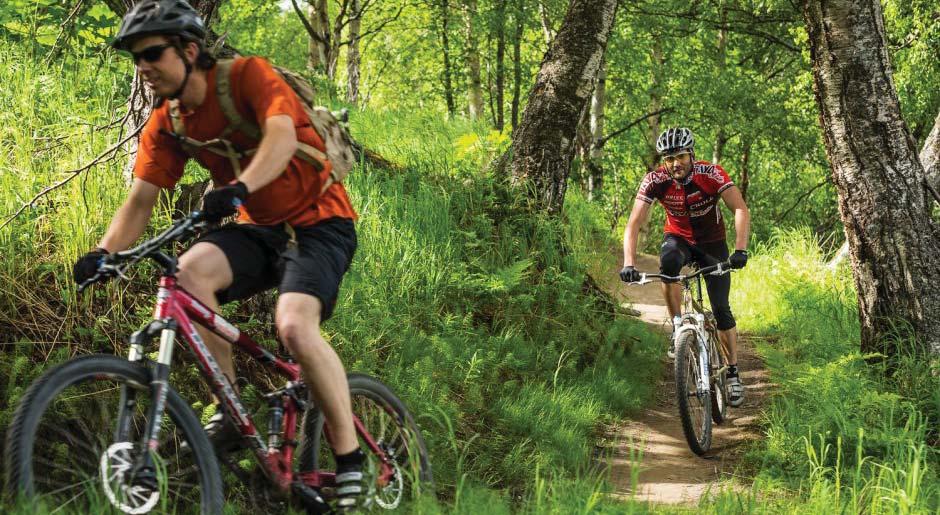
13 and enjoyment of the City s natural, cultural and recreational features and enhancing their public appreciation while preserving their natural heritage values and ecological functions; Developing and managing the trail system in a manner that preserves the environment, is financially responsible, and encourages opportunities for partnership and stewardship; Connecting the City s trail system to larger Provincial trails systems such as; the Bruce Trail, the Hamilton- Brantford Rail Trail, Hamilton Conservation Authority Trails and the Lake Ontario Waterfront Trail; Identifying recreational and commuter needs for pedestrians, cyclists and other trail users; Integrating wayfi nding as part of the trail design to promote safety, connectivity, and educational opportunities; and Establishing recommendations and strategic priorities for the City to consider increasing connectivity within the trail network. An important aspect of the Recreational Trails Master Plan is the promotion of trail use and trail activities. Promotion can include education, outreach and stewardship initiatives which are used to raise awareness of the health, environmental, social and economic benefi ts of investing in trail infrastructure. For a community with the size, population, and cultural background such as the City of Hamilton, and its position within the province poised for substantial growth and development, it is essential to establish long-term strategies to facilitate the development of healthy and sustainable communities. 1.3 The Benefits of Trail Development ACTIVE2010 is the Province s strategy to increase levels of physical activity among Ontarians for personal health benefi ts, and to reduce overall health care costs. The Ontario Trails Strategy is a long-term plan prepared in 2006 as part of the ACTIVE2010 strategy. It establishes strategic directions to assist in the planning, management, promotion, and use of trails in Ontario, and was developed in collaboration with other Provincial ministries and a wide range of stakeholders. The Ontario Trails Strategy focuses on all single and shared-use outdoor designated trail networks in urban, rural and wilderness settings that are used for recreation, active living, utilitarian and tourism purposes including but not limited to: Trails with natural (e.g. hiking, cross-country skiing) or treated surfaces (i.e bicycle greenways/paths/lanes) On-road bicycle routes Walkways, boardwalks and sidewalks Trails located on transportation and utility corridors Access roads (e.g. for forestry and mining) designated for trail use Trails that are integrated with public transit services Waterway routes (e.g. along designated Canadian heritage rivers including the French, Humber, Mattawa, Rideau and Thames Rivers) and portage routes The Ontario Trails Strategy also identifi es a number of potential benefi ts to communities that can be realized through trails and trail-related activities. These include: Support for Active Living Having access to trails encourages an active lifestyle. With many urban residents experiencing increasingly busy lives, they are more encouraged to seek fi tness opportunities through access to unstructured recreation activities, such as walking, cycling and jogging, all of which are well suited to outdoor trails. As an example, 30 minutes of brisk daily walking is all that is needed for improved fi tness levels, and health benefi ts (Ontario Trails Strategy, 2006). Social Benefits Trails can help build the social fabric of a community, physically connecting neighbourhoods and outlying communities together, and encouraging casual interactions. Several city trails have been developed in a collaborative manner with community volunteers and local sponsors. By linking shopping, entertainment, workplaces, and parks, trails can help to promote alternative transportation, and contribute to economically and environmentally sustainable and liveable communities. Trails offer low cost, unstructured recreation that can be enjoyed in solitude, by families, and as group activities. Trails are available to all ages and the associated activities (e.g. bird watching, walking, cycling, crosscountry skiing, etc.) can be relatively inexpensive in comparison to other recreation activities that have user fees and/or require expensive equipment. With appropriate design, many urban trails can be made physically accessible to a wide range of skills and abilities. Many trails can be used in all seasons, through a variety of activities. Trails offer leisurely opportunities to appreciate and enjoy nature, and the surrounding community. HAMILTON RECREATIONAL TRAILS MASTER PLAN DRAFT 2015 PAGE 3

14 Figure 3: Having access to trails encourages an active lifestyle Environmental Benefits Trails support both urban and rural recreational lifestyles and can support broader environmental and ecological objectives through the protection of greenspace corridors. By rationalizing and re-routing random and informal paths, designed trails can serve to keep users away from sensitive environmental areas. The use of trail maps and interpretive signage can help to enhance appreciation and awareness of nature and promote environmental stewardship. Economic /Tourism Benefits Trails promote a high quality of life for communities and indicate a desirable place to both live and operate a business. Trails can be used to connect key destinations such as natural parks, cultural heritage features, or other community amenities and in doing so can encourage visitation by both local residents and tourists. Trails can create both jobs directly and indirectly through construction as well as relating to tourism and visitation. This might include restaurants, lodging, food, and beverage. Many trail users purchase local goods to support their trail activities (e.g. bikes, jogging gear, hiking shoes, etc.) These purchases contribute to the local economy through jobs and taxes. HAMILTON RECREATIONAL TRAILS MASTER PLAN DRAFT 2015 PAGE 4
15 1.4 The Organization of the Master Plan Report The Recreational Trails Master Plan has been developed with the objectives of linking to external trail networks; improving access to trails; improving connectivity throughout the City; encouraging alternative transportation; enhancing recreational and health benefi ts; and promoting awareness and use of existing trails. The goal of the Recreational Trails Master Plan Update is to create a document that addresses route planning; trail standards; and the development of phasing and priorities. The structure of the master plan report has been organized to refl ect the intent that it be utilized as a working tool. Sections are organized as follows: 1.0 Study Introduction 2.0 The Trails Network 3.0 The Implementation Plan 4.0 Appendix A Appendix B Trail Network Maps Figures Tables Summary of Public Engagement Activities Summary of Public Engagement Activities Summary of Existing Policies and Plans The City of Hamilton has a series of well-developed urban trails but improvements can be made to the connectivity of the system. There is potential to provide opportunities for residents and visitors to become more physically active by providing a trails network that will connect all parts of the city and link to external trail systems. Overall the master plan report focuses on several key areas of importance including: Guiding the development of a comprehensive multipurpose trail system; Identifi cation and classifi cation of recreation off-road trails in accordance with their use e.g. commuting, recreation) and character (e.g. natural, environmental signifi cance or urban areas); Collaborative trail management and development standards that meet varying commuting needs and opportunities in a manner consistent with municipal land use, transportation, natural/cultural, heritage and sustainable development policies; Design methods intended to create trail gateways and scenic vistas to enhance a positive public image of the City of Hamilton and to improve the local user and tourist experience; Economic impacts of trails including expansion and redevelopment of the commercial core; Preservation and conservation of wooded areas and sensitive ecological habitat; New development will be directed away from signifi cant natural features such as the wetlands streams throughout the City; Recognition of the importance of improving the movements of automobile traffi c and new pedestrian facilities in neighbourhoods; Consideration of applicable City of Hamilton policies, by-laws, documents, guidelines and recommendations which include but is not limited to: Urban & Rural Hamilton Offi cial Plans Secondary Plans Zoning By-Law(s) Pedestrian Mobility Plan, Cycling Master Plan, Active Transportation documents, Transportation Demand Management documents Accessibility/Barrier-Free Design Guidelines, etc The Cultural Plan ( Love Your City ) Community facilities developed to serve the expanding residential community, the adequacy of school sites, and other community facilities; and Safety and security in the community. The level of service provided will be appropriate to the needs of both the rural and urban residents. Although the City is recognized for its agricultural lands, it is becoming an urban centre with accelerated future growth. Trail linkages to the downtown and throughout new developing areas can ensure proper trail infrastructure which will support sustainable future growth in the City. HAMILTON RECREATIONAL TRAILS MASTER PLAN DRAFT 2015 PAGE 5


16 Figure 4: Chedoke Radial Trail 2.0 THE TRAILS NETWORK
17 The main goal in developing the Recreational Trails Master Plan Update was to establish key strategic priorities that will facilitate a continuous and connected off-road trail system to accommodate recreational and utilitarian / commuter travel. The project approach used to develop the master plan update required constant communication with the City, elaborate public consultation, and a rigorous and comprehensive review of the existing network and associated facilities. The public and stakeholder consultation process is discussed in greater detail within Appendix A: Summary of Public Engagement Activities. Each consultation event formed a key component of the project and ultimately led to the development of the updated master plan report. In order to create an updated master plan report we must fi rst review what was previously completed in Understanding what has Already Been Done: The Previous Trail Master Plan (2007) The City of Hamilton Recreational Trails Master Plan is a comprehensive document which prescribes a multi-use, recreational trail system throughout the City of Hamilton. This system links both the current and proposed off-street as well as on-street systems into a fully integrated, Citywide based system. This document is intended to guide trail systems, development and management throughout the City from the present into the future, providing clear direction and decision making capabilities. In 2007, the City of Hamilton completed the former Recreational Trails Master Plan (prepared by O Connor Mokrycke Consultants). The master plan was adopted by Council and included: Completion of a comprehensive multi-purpose trail system; Identifi cation and classifi cation of recreation off-road trails in accordance with their use and character; Collaborative trail management and design development guidelines; A proposed network of off-road and on-road routes; Network implementation recommendations; Suggestions to raise awareness about Hamilton trails, encourage trail use and educate users on trail usage and etiquette; Trail maintenance recommendations; and Implementation of applicable City of Hamilton Offi cial Plan and Transportation Master Plan policies and recommendations. The 2007 plan has been the guiding document for City trail development for the past nine years. A number of soft and hard infrastructure projects have been realized throughout the City of Hamilton based on the implementation strategies es identifi ed within the document. 2.2 The Trail Master Plan Update Process This report update proposes a wide variety of trail projects of differing sizes and complexity throughout the City of Hamilton. Some projects need new facilities requiring further design and analysis, while others are smaller expansions or upgrades to existing trails or trail amenities. The Hamilton Recreational Trails Master Plan was updated between March 2015 and January All trail initiatives within the 2007 report were updated and new initiatives were added to the report. Extensive public involvement, that helped to shape and guide the master plan update, included: Eight (8) public consultation meetings between April and September 2015; Stakeholder meetings between April and September 2015; Trail questionnaires, issued in both paper and electronic format; Key agency liaisons and discussions; Input from City of Hamilton Cycling Advisory Committee and various City department staff; Online survey available April 2015 to October 2015 Feedback for general comments As this is a master plan, some key steps have been expanded to reflect work previously completed as part of the 2007 Recreational Trails Master Plan, and analysis of this work to inform the development of this master plan report. The steps used to develop this document included: 1. Collecting and assembling relevant background data and information 2. Reviewing and refi ning route selection guidelines 3. Reviewing previously developed trails network initiatives and identifying potential new routes 4. Reviewing existing trail initiatives by conducting comprehensive fi eld investigations and site visits 5. Preparing trails network mapping 6. Preparing route priorities and implementation strategies 7. Finalizing updated trail networks with refined trail initiatives HAMILTON RECREATIONAL TRAILS MASTER PLAN DRAFT 2015 PAGE 7
18 Table 1: Public Consultation Activities Summary Chart Timeline: April September 2015 Public Information Session #1 - Wednesday, April 22, Hamilton Environmental Summit Public Information Session #2 - Thursday, May 21, Building Momentum Hamilton Public Information Session #3 - Saturday, June 6, Chedoke Stairs (Let s Talk Trails table) Public Information Session #4 - Sunday, June 7, TrailHead Ontario 2015 Conference Public Information Session #5 - Friday, July 10, Hamilton Farmer s Market (Let s Talk Trails table) Public Information Session #6 - Sunday, August 9, Festival of Friends Public Information Session #7 - Friday, August 21, Bayfront Park (Let s Talk Trail table) Public Information Session #8 - Thursday, September 24, Ward 13 Dundas Town Hall Let s Talk Trails Questionnaire - a 13 question paper questionnaire was created for the fi rst public consultation event (Hamilton Environmental Summit). A total of 33 participants completed the questionnaire as well as marked up existing city trails mapping with comments. Online Survey - a 10 question online survey was created using Survey Monkey and promoted throughout the City. A total of 138 responses were received between April 2015 and September Online Study Promotion - project information was posted on the City of Hamilton website which included a project description, project updates, information regarding public consultation, link to the online questionnaire, and Twitter promotion of project and online questionnaire Let s Talk Trails table - the City hosted two Let s Talk Trails table s which were smaller versions of a public information centre used to gather feedback from the public Four Meetings with City Staff (Project Working Group) - March 30, 2015, July 29, 2015, September 14, 2015, and September 18, Trails Master Plan Opportunities The 2007 Recreational Trails Master Plan established trail design principles. Several of those design principles have been expanded upon below as opportunities relevant to this Recreational Trails Master Plan: Multi-purpose recreation trails generally service varying skill levels, Hamilton s trails are also oriented to less experienced trail users in order to encourage higher activity levels among Hamilton s residents; Promoting recreation trails, as alternative modes of transportation, and mixed land uses can bridge the gap between urban form and health, creating healthy and sustainable communities to combat increased commuting time and physical inactivity can be attributed to sprawling urban form; Urban and rural recreational trails address different needs and opportunities; Public safety should be addressed in multiple ways. The trail design standards address the needs of specifi c users and varying skill levels. Confl icts between users may require some trails be single purpose and seasonal, while others be multiple use and all weather trails. Where multiple uses exist or are anticipated, surface treatment and width standards should be addressed accordingly; Hamilton is unique within the provincial context balancing the relationship between the built environment and the natural geography of the Niagara Escarpment bisecting the City, Cootes Paradise to the west and a large industrial sector to the north along the south shore of Lake Ontario. The trail system should maintain the balance between built and natural settings through its guidance in strengthening the overall trail network; HAMILTON RECREATIONAL TRAILS MASTER PLAN DRAFT 2015 PAGE 8
19 The Recreational Trails Master Plan Update should function as one component in the larger vision to create a sustainable trail and cycling network. In order to do this, the Plan should collaborate with both Public and Private sector groups that promote sustainability; Trails should not only be used for recreation (e.g. exercise) and commuting (e.g. transportation). They should also function as a linkage to community facilities, such as parks, community gardens, etc.; and Wayfi nding should be an integral part of the trail design to promote safety, navigability and educational opportunities Guidelines for Trail Development and Route Selection Trails within the City facilitate city-wide travel and are the primary resource in connecting parks, recreational centres, schools, commercial sites, cultural and institutional centres, transit facilities and numerous residential neighbourhoods. One of the key 2007 Recreational Trails Master Plan deliverables was the development of design guidelines and standards for trail facilities throughout the City. The design guidelines, identifi ed in Section 4.0 of the 2007 Recreational Trails Master Plan, were a thorough development of trail classifi cation and standards which refl ected the desire for a more diverse system of on-road and off-road facilities. The 2007 document identified a trail hierarchy which comprised of three different trail types. Facility types were also noted for each of the different trail classifi cation. This Recreational Trails Master Plan Update discusses and expands upon those classifi cations and guidelines to refl ect current industry standards and best practices. This information can be found within Section 2.3. As the City of Hamilton undertakes the task of implementing the trail network and proceeds with detailed design for key linkages, there may be some scenarios where alternate routes, not originally identifi ed in this report update, are a more feasible alignment. There may also be scenarios where opportunities offered by unopened road allowances, hydro corridor rights-of-way, abandoned rail corridors, open space, future roadway improvements, partnerships and funding initiatives become available. Trail routes within Hamilton will be selected and designed based on the following principles: Planned: Trails will be considered an integral component of all community planning and development. Connected: Trails will serve to connect the urban and rural communities of Hamilton, both internally and externally, and will link key destinations. Improved wayfi nding will also be incorporated into the trails network. Diverse: The trail system will be designed to appeal to a wide range of users, abilities and interests. Inspiring: Trails will promote and encourage use and enjoyment of the City s natural, cultural and recreational features. Accessible: The trail system will provide opportunities for four-season use, and will include a core network of trails that are accessible to people of all ages and abilities. Safe and Inviting: Safety, security and user comfort will be considered in the design and management of the trail system. Sustainable: The trail system will be developed and managed in a manner that preserves the environment, is fi nancially responsible, and encourages opportunities for partnership and stewardship. The existing trail system has its strengthens and this Recreational Trails Master Plan Update represents an opportunity to assemble, investigate and prioritize opportunities that link together the existing trails system and to extend trails to connect to an regional system Inventory of Existing Trails and Fieldwork Methodology An initial step in the development of the Master Plan Update was the documentation and assessment of existing 2007 trail initiatives. Section summarizes the existing 2007 trail initiatives and their current implementation status, as well as expands upon new trail initiatives. It is important to understand the infrastructure which is currently in place, and to ensure that the Master Plan Update is built upon what has already been completed and highlights previous successes (e.g. East Hamilton Link Waterfront Pedestrian Bridge). One of the primary goals of the Master Plan Update was to develop a connected and continuous network of trails and to provide linkages between the City s urban and rural areas. A detailed desktop and fi eld review of all existing (2007) trail initiatives and proposed 2015 trail initiatives was undertaken. Fieldwork was completed for all fi fteen Wards over several weeks between July and October To assist in reviewing each site, current available City GIS mapping and the Hamilton Bikeways, Trails and Parks Map were studied. Fieldwork consisted of qualitative written observations, noting existing trail or route conditions, features and photographing all sites. Site photographs were taken with either an S.L.R. or digital camera using a 50 mm equivalent lens. Sites were visited either on foot, by HAMILTON RECREATIONAL TRAILS MASTER PLAN DRAFT 2015 PAGE 9
20 mountain bike, by car or a combination of each for effi ciency purposes. Prior to commencing fi eldwork, draft data sheets and mapping were developed by the consulting team based upon available data, desired data required by the City of Hamilton, related information and experience of the Consultants. The Consultants updated the existing 2007 Master Plan report mapping to reflect the current City mapping prior to fi eldwork. Once all fi eldwork was completed the mapping was further updated using electronic data provided by the City. Potential alignments were reviewed with aerial photographs where available and verifi ed in the fi eld and in discussions with City staff. Analysis of Fieldwork One goal of the study was to review opportunities for expanding and improving trails on a city wide basis. While the primary focus was on off-street multi-purpose recreation trails, opportunities to improve on-street links were also considered. In this regard, sites were considered using a number of criteria including, but not limited to, general location, degree of difficulty rating, classifi cation, trail gradient, accessibility rating, ownership and links to other trails. These are summarized on a ward by ward basis, noting ward number and initiative number. Existing and new individual ward trail initiatives are summarized in the tables shown in Section The Proposed Trail Network The City of Hamilton is situated in close proximity to many environmentally and culturally interesting places and already has trails that offer a diverse range of experiences. Many of the trails are disconnected from each other and a priority for trail development is to fi ll in the missing local links and expand the network to reach beyond its boundaries. The Recreational Trails Master Plan Update takes into account the 2007 trail initiatives previously constructed and plans for future growth and trail network expansion. The Recreational Trails Master Plan Update is based on a hierarchy of trail types that refl ect type of use, location, and environmental considerations. Throughout the process many other opportunities were identifi ed for the creation of trail segments connecting new neighbourhoods to the network, and extending the local trail system to link other municipalities and areas of environmental and cultural signifi cance. These trails are to be considered in long term planning processes and should continue to be investigated and implemented as opportunities arise. a) Individual Ward Characteristics The trail network includes trail planning in all fi fteen City Wards. The Recreational Trails Master Plan is divided into the individual City Wards (Maps 1 to 15) for the purposes of describing the trail system projects by individual Ward in greater detail. The table below summarizes the individual characteristics, built and natural features, and recreational trail design opportunities within each Ward. Table 2: Summary of Individual Ward Characteristics Ward 1: Chedoke-Cootes Description Urban ward, situated in the west end of Hamilton below the Niagara Escarpment Located within the Hamilton Conservation Authority and Conservation Halton watersheds Bordered by the Niagara Escarpment to the south, Queen Street to the east, Hamilton Harbour and Cootes Paradise to the north, and a green corridor running from Cootes Drive along the border of the former City of Hamilton and Town of Dundas. Divided by Highway 403 corridor running from the north-east to south-west. Built and Natural Features Contains portions of the Hamilton-Brantford Rail Trail, Chedoke Rail Trail (and Chedoke Stairs), Bruce Trail, and Waterfront Trail Hamilton Harbour Cootes Paradise Chedoke Ravine Niagara Escarpment McMaster University (part of Hamilton Health Sciences) McMaster Innovation Park Chedoke Golf Civic Course Dundurn National Historic Site Hamilton Military Museum Royal Botanical Gardens HAMILTON RECREATIONAL TRAILS MASTER PLAN DRAFT 2015 PAGE 10
21 Recreational Trail Design Opportunities Trail connection from Cootes Drive to Osler Drive (Main Street West) and to McMaster University (Initiative 1-1) Trail connections described in the Churchill Park Master Plan (Initiative 1-2) Trail connection from Macklin Street North under Highway 403 through Kay Drage Park/ Cathedral Trail to Christ the King Cathedral (Initiative 1-6) Trail connection beside Chedoke Municipal Golf Course along Beddoe Drive and Studholme Road (Initiative 1-9) Trail (bridge) connection over CN tracks connecting Locke St. to the Waterfront Trail, south of Bayfront Park (Initiative 1-14) Trail connection through CN Yard (within City easement) to Stuart Street (Initiative 1-15) Ward 2: Downtown Description Built and Natural Features Urban ward situated in the centre of the city below the Niagara Escarpment Smallest ward, and is located within the Hamilton Conservation Authority watershed Contains Bayfront Park and Pier 4 Park, as well as the Waterfront Trail which links Wards 1 and 2 City Hall Jackson Square Gore Park First Ontario Centre Hamilton Farmer s Market Whitehern Historic House & Garden Marine Discovery Centre West Harbour GO Station St. Joseph s Hospital Art Gallery of Hamilton Hamilton Place Cannon Street bike lanes Recreational Trail Design Opportunities Boulevard trail connection along southern side of Strachan Street between James Street and Ferguson Avenue. Portion of trail not completed to be undertaken by Hamilton Public Works.(Initiative 2-2) Boulevard trail connection along Burlington St. from Bay St. (Pier 4 Park entrance) to Ferguson Ave./ Eastwood Park (Initiative 2-6) Ward 3: Hamilton Centre Description Built and Natural Features Urban ward situated in the lower city below the Niagara Escarpment Located within the Hamilton Conservation Authority watershed Approximately 1/3 of Ward is comprised of industrial and commercial land including U.S. Steel Canada and ArcelorMittal Dofasco The Escarpment Rail Trail is situated on the Niagara Escarpment Hamilton General Hospital Hamilton s Children Museum St. Peter s Hospital Tim Hortons Field Gage Park Industrial and Port facilities Rail infrastructure Tight grid residential fabric HAMILTON RECREATIONAL TRAILS MASTER PLAN DRAFT 2015 PAGE 11
22 Recreational Trail Design Opportunities On street boulevard connection along Burlington Street from Ferguson Avenue/ Eastwood Park to Gage Avenue (Initiative 3-3) Boulevard trail connection along Ottawa St. S. from Lawrence Ave. trail connection to Pipeline Trailhead/ parking lot at Main St. E. (Initiative 3-6) Ward 4: East Hamilton Description Urban ward situated in the lower city below the Niagara Escarpment Located within the Hamilton Conservation Authority watershed Almost ½ of Ward is comprised of industrial and commercial land including ArcelorMittal Dofasco The Escarpment Rail Trail and Red Hill Valley Parkway trail systems border the Ward Built and Natural Features Recreational Trail Design Opportunities Hamilton Museum of Steam and Technology Centre on Barton Pipeline Trail Red Hill Valley Hamilton Harbour/Windermere Basin Industrial and Port facilities Rail infrastructure Trail connection from Woodward Avenue to Globe Park through the Museum of Steam and Technology (Initiative 4-3) New multi-use trail along hydro corridor from Barton Street to Lawrence Avenue with connection to Pipeline Trail (Initiative 4-4) Trail development associated with Pipeline Trail Master Plan (Initiative 4-5) On-road connection Dunsmure Rd./Reid Ave. S. intersection along Glengrove Ave. to connect to future Red Hill Valley Parkway trail bridge. (Initiative 4-6) Ward 5: Red Hill Description Built and Natural Features Urban ward situated in the lower city below the Niagara Escarpment Located within the Hamilton Conservation Authority watershed Includes the beach strip up to the Canal Bridge and the ship canal which separates the cities of Hamilton and Burlington The Escarpment Rail Trail and Red Hill Valley Parkway trail systems border the Ward St. Joseph s Community Health Centre Eastgate Square Confederation Park King s Forest Public Golf Course Greenhill Valley Queen Elizabeth Way (QEW) Lincoln Alexander Parkway Red Hill Valley Parkway The Bruce Trail Recreational Trail Design Opportunities Lake Avenue Park trail connections (Initiative 5-4) Hydro corridor trail connection west of Cochrane Road to Greenhill Avenue, Rosedale Park and Kings Forest Golf Course (Initiative 5-6) Trail connection along closed road allowance/boulevard from Bruce Trail to Battlefi eld Park (Initiative 5-8) Trail (bridge) over Red Hill Valley Parkway connecting Eugene St. and Glengrove Ave. (Ward 4) (Initiative 5-9) HAMILTON RECREATIONAL TRAILS MASTER PLAN DRAFT 2015 PAGE 12
23 Ward 6: East Mountain Description Built and Natural Features Urban ward situated in the east end of Hamilton on the Niagara Escarpment Located within the Hamilton Conservation Authority boundary watershed Divided by the Lincoln Alexander Parkway and includes the interchange with the Red Hill Valley Parkway Mount Albion Conservation Area Niagara Escarpment and the Bruce Trail East Mountain Trail Loop Stairs at East Escarpment (Margate) Mount Albion Falls Felker s Falls Conservation Area Mohawk Sports Park (Bernie Arbour Stadium) Upper Kings Forest Park Lincoln Alexander Parkway Recreational Trail Design Opportunities On Street/ boulevard trail connection along Stone Church Road to Albion Falls bridge over Red Hill Valley Parkway (Initiative 6-2) On Street/ boulevard trail connection along Stone Church Road and Upper Ottawa Street (around City Forestry Yard) (Initiative 6-4) Ward 7: Central Mountain Description Urban ward, situated in the centre of Hamilton on the Niagara Escarpment Located within the Hamilton and Niagara Peninsula Conservation Authorities watershed Divided by the Lincoln Alexander Parkway Built and Natural Features Limeridge Mall Sackville Hill Senior s Centre Sam Lawrence Park Henderson General Hospital Juravinski Cancer Centre Lincoln Alexander Parkway Mount Hamilton Cemetery Recreational Trail Design Opportunities Multi-use trail connection along hydro corridor from Limeridge Mall to hydro corridor trails in Ward 11. (Initiative 7-1) Boulevard trail connection along Rymal Rd. E. from Acadia Dr./hydro corridor to Upper James St. W. (Initiative 7-2) Trail connections (on-road and off-road) from William Connell Park through neighbourhoods and parks to connection to Rymal Rd. E. boulevard trail (Initiative 7-3) Ward 8: West Mountain Description Urban ward, situated in the west end of Hamilton on the Niagara Escarpment Located within the Hamilton and Niagara Peninsula Conservation Authorities watershed Divided by the Lincoln Alexander Parkway HAMILTON RECREATIONAL TRAILS MASTER PLAN DRAFT 2015 PAGE 13
24 Built and Natural Features Chedoke Rail Trail and Chedoke Stairs Mohawk College of Applied Arts and Technology Chedoke Hospital St. Joseph s Mental Health and Wellness Resource Centre Niagara Escarpment Portions of the Tiffany Creek and Twenty Mile Creek watershed Recreational Trail Design Opportunities Trail connection from Olympic Park north through hydro corridor to Scenic Drive (Initiative 8-2) Boulevard trail connection along south side of Rymal Road W from Garth Street to Upper James Street (with continuation to Turner Park in Ward 7) (Initiative 8-4) Garth Street Reservoir trail with connection into William Connell Park (Initiative 8-5) Trail development associated with William Connell Park Master Plan (Initiative 8-6) On-road/ boulevard trail connections from James Mountain Rd./Bruce Trail access through Mohawk College/ Hillfi eld Strathallan College/ St. Joseph s Heathcare Campus to Bendamere Ave. (Initiative 8-7) Ward 9: Heritage Stoney Creek Description Urban and rural ward that straddles the Niagara Escarpment and is situated in the east end of Hamilton Located within the Hamilton and Niagara Peninsula Conservation Authorities watershed 1/5 of the Ward is located below the Escarpment Built and Natural Features Historic old town of Stoney Creek Battlefi eld House Museum and Park Heritage Green Sports Park Devil s Punch Bowl Conservation Area Niagara Escarpment Felker s Falls Eramosa Karst Conservation Area Red Hill Valley Parkway The Bruce Trail Recreational Trail Design Opportunities Trail link from Pritchard Rd. to Eramosa Karst Conservation Area (Upper Mount Albion Rd.) (Initiative 9-1) Trail link from escarpment/waterfalls to Green Mountain Road West (Initiative 9-3) Trail development associated with Heritage Green Sports Park Master Plan. (Initiative 9-5) Ward 10: Stoney Creek Description Built and Natural Features Urban ward situated below the Niagara Escarpment with an industrial and commercial corridor south of the QEW Located within the Hamilton Conservation Authority watershed Mohawk College STARRT Institute Hamilton Waterfront Trail The Bruce Trail Queen Elizabeth Way (QEW) Highway 8 The Niagara Escarpment Recreational Trail Design Opportunities No proposed trail initiatives HAMILTON RECREATIONAL TRAILS MASTER PLAN DRAFT 2015 PAGE 14
25 Ward 11: Glanbrook, Stoney Creek, Winona Description Built and Natural Features Rural ward with some pockets of light industrial and commercial lands south of the QEW corridor Located within the Hamilton, Niagara Penninsula, and Grand River Conservation Authorities watersheds Majority of Ward 11 is located on top of the Escarpment Fifty Point Conservation Area on Lake Ontario (HCA) Binbrook Conservation Area (NPCA) John C. Munro Hamilton International Airport Stoney Creek Airport Queen Elizabeth Way (QEW) The Bruce Trail The Niagara Escarpment Town of Binbrook Recreational Trail Design Opportunities Hydro corridor trail connection from Turner Park to Trans-Canada Trail east of Nebo Road (Initiative 11-7) Hydro corridor trail connection from Trans-Canada Trail/Nebo Road to Fletcher Rd. (Initiative 11-8) Binbrook connections to new developments and parks (Initiative 11-10) Ward 12: Ancaster Description Built and Natural Features Mix of urban and rural uses and is comprised of the former Town of Ancaster Located within the Hamilton, Niagara and Grand River Conservation Authorities watershed Redeemer University College Part of the Dundas Valley Conservation Area Iroquoia Heights Conservation Area Tiffany Falls Conservation Area Meadowlands Power Centre Ancaster Business Park Highway 403 Highway 6 Lincoln Alexander Parkway The Niagara Escarpment Recreational Trail Design Opportunities Filman Road Trail link from pedestrian bridge over Highway #403 to below escarpment to end of Filman Road. (Initiative 12-2) Meadowlands Trail System from Highway 403 to Garner Road. Multiple sections to complete system, connect natural areas, stormwater ponds, neighbourhoods and future hydro trails. Coordinate with HCA trail development initiatives (Initiative 12-7) Meadowlands hydro corridor trail connection from Tiffany Creek to Garner Road (Initiative 12-8) Boulevard Trail along Glancaster Road from Garner Road to Twenty Road (Initiative 12-9) Hydro corridor trail connection from Glancaster Road (east) to Trinity Road (west) (Initiative 12-10) Trail connection from existing park (Weldon Ln. & Myers Ln.) to Tollgate Dr. (Initiative 12-11) Trail connection from Tollgate Dr. trail (initiative 12-11) to Hamilton Dr. (Initiative 12-12) Trail connection from Hamilton Dr. to Panabaker Dr. (Initiative 12-3) HAMILTON RECREATIONAL TRAILS MASTER PLAN DRAFT 2015 PAGE 15
26 Ward 13: Dundas Description Urban and rural ward comprised of the former Town of Dundas Located within the Hamilton and Halton Conservation Authority watersheds Built and Natural Features Dundas Valley School of Art The Dundas Valley Conservation Area (Borer s Creek, Webster s Falls, Tew s Falls, Spring Creek) Large section of the Royal Botanical Gardens Cootes Paradise Town of Dundas The Niagara Escarpment The Bruce Trail Recreational Trail Design Opportunities Trail connection from Main Street Staircase east to drainage ditch, new trail from drainage ditch to east of Thorpe St./Dundas St. (Initiative 13-2) Trail connection from Osler Drive/Spencer Creek Trail east to Edwards Memorial Park (Initiative 13-4) Upgrade old rail bed and foot path from Bond Street to west end of Cascade Subdivision/Park (Initiative 13-5) Dundas Valley Trail Link, Governor s Road to King Street West. Upgraded or second trail adjacent to Bruce Trail (Initiative 13-6) Ward 14: Wentworth Description Primarily a rural ward City s largest ward Contains many small rural communities Located within the Hamilton, Halton and Grand River Conservation Authority watersheds Built and Natural Features Hamilton-Brantford Rail Trail Lafarge 2000 trail Westfi eld Heritage Village African Lion Safari Hamilton Conservation Authority Main Offi ce Christie Lake Conservation Area Crook s Hollow Conservation Area Valens Conservation Area and Valens Reservoir Highway 403 Contains rural communities such as Greensville, Millgrove, Freelton, Valens, Hayesland, Strabane, Westover, Kirkwall, Sheffi eld, Rockton, Troy and Copetown Recreational Trail Design Opportunities Connection through HCA lands from Harvest Road parking lot north to Highway 5 (Initiative 14-1) Trail connection from 10th Concession West east to Valens Road and Valens Reservoir (Initiative 14-4) HAMILTON RECREATIONAL TRAILS MASTER PLAN DRAFT 2015 PAGE 16

 Multi-use trail from Parkside Drive to Center Road and through neighbourhood north of Parkside Drive (Initiative 15-2) Link")
27 Ward 15: Flamborough Description Primarily a rural ward but includes some light industrial and commercial land Located within the Hamilton and Halton Conservation Authority watersheds North-west edge of the ward runs from Mountsberg Conservation Area Built and Natural Features Spencer Gorge/Webster s Falls Conservation Area Town of Waterdown Town of Carlisle Niagara Escarpment related features in Carlisle (Bronte Creek), Waterdown (Grindstone Creek/valley and Medad Valley) The Bruce Trail Recreational Trail Design Opportunities Borer s Creek trail connection from Highway 6 to Rock Chapel Golf Centre and through residential neighbourhoods to the east (Initiative 15-1) Multi-use trail from Parkside Drive to Center Road and through neighbourhood north of Parkside Drive (Initiative 15-2) Link from Borer s Creek Trail to new communities planned to the north (Initiative 15-3) Trail connection through Joe Sam s Leisure Park (as new development occurs) (Initiative 15-4) Trail connection from hydro corridor to Parkside Drive to Robson Road (Initiative 15-5) Loop trail through new community south of Highway 5 with connection to hydro corridor trail (Initiative 15-6) Hydro corridor trail connection from Waterdown Wetland Trail in Joe Sam s Leisure Park to Mountain Brow Rd. (Initiative 15-7) Multi-use trail connection from King Road along Mount Brow Rd. (future closed road allowance) (Initiative 15-12) Figure 5: Asphalt trail along the Chedoke Radial Trail Figure 6: Many trails in Hamilton are routed through scenic and natural areas HAMILTON RECREATIONAL TRAILS MASTER PLAN DRAFT 2015 PAGE 17
28 b) Existing 2007 Trail Initiatives The table below summarizes all existing 2007 trail initiatives, including an update on their status, location, and trail amenity recommendations. Table 3: Summary of 2007 Trail Initiatives Ward Initiative Status Location Summary Trail Amenity Recommendations 1 Proposed Trail 2 Proposed Trail 3 Trail connection from Cootes Drive to Osler Drive (Main Street West) and to McMaster University. Trail connections in association with the Churchill Park Master Plan. Removed Unable to construct trail along water as per RBG recommendations New Trailhead / Directional Signage New Trailhead / Directional Signage 4 Removed Unable to construct trail along water Proposed Trail Proposed Trail 10 Constructed/ Completed Trail connection from Macklin Street North under Highway 403 through Kay Drage Park/ Cathedral Trail to Christ the King Cathedral. Constructed/ Completed; Alignment follows Chedoke Rail Trail Constructed/ Completed; Alignment follows Chedoke Rail Trail Constructed/ Completed Trail connection beside Chedoke Municipal Golf Course along Beddoe Drive and Studholme Road to tot lot. New Trailhead / Directional Signage New Trailhead / Seating Constructed/ Completed Constructed/ Completed Constructed/ Completed Constructed/ Completed 2 2 Proposed Trail Boulevard trail connection along southern side of Strachan Street between James Street and Ferguson Avenue. Portion of trail not completed to be undertaken by Hamilton Public Works. In conjunction with Public Works Constructed/ Completed Constructed/ Completed Removed Not required as initiative within 2015 Trail Master Plan Update Constructed/ Completed Proposed Trail 4 Constructed/ Completed Boulevard trail connection along Burlington Street from Ferguson Avenue/ Eastwood Park to Gage Avenue Removed Unnecessary trail connection through industrial lands Traffic Control Required; Directional Signage and Pavement Markings 5 1 Removed Unable to construct and not required as initiative within 2015 Trail Master Plan Update Constructed/ Completed 4 2 Constructed/ Completed 3 Proposed Trail Trail connection from Woodward Avenue to Globe Park through the Museum of Steam and Technology. New Trailhead/ Directional Signage 4 Proposed Trail New multi use trail along hydro corridor from Barton Street to Lawrence Avenue with connection to Pipeline Trail (initiative 4 5). New Trailhead / Interpretive Signage 1 2 No improvements to existing natural footpath Constructed/ Completed Proposed Trail Lake Avenue Park connection 5 6 Proposed Trail 7 Removed Unable to build trail along CN corridor on CN lands. Removed Not required as initiative within 2015 Trail Master Plan Update New Trailhead / Directional Signage New Benches / Seating Area Hydro corridor trail connection west of Cochrane Road to Greenhill Existing Trailhead / Interpretive Signage Avenue, Rosedale Park and Kings Forest Golf Course. New Benches / Seating Area No improvements to existing natural footpath HAMILTON RECREATIONAL TRAILS MASTER PLAN DRAFT 2015 PAGE 18
29 6 1 Constructed/ Completed On Street/ boulevard trail connection along Stone Church Road to 2 Proposed Trail Albion Falls bridge over Red Hill Valley Parkway. 3 Constructed/ Completed Traffic Control Required; Directional Signage and Pavement Markings 4 Proposed Trail On Street/ boulevard trail connection along Stone Church Road and Traffic Control Required; Directional Upper Ottawa Street (around City Forestry Yard) Signage and Pavement Markings Proposed Trail New Trailhead / Interpretive Signage Trail connection from Olympic Park north through hydro corridor to New Benches / Seating Area Scenic Drive Traffic Control Required; Directional Signage and Pavement Markings 3 Constructed/ Completed 4 Proposed Trail 5 Proposed Trail 1 Proposed Trail 2 3 Proposed Trail Boulevard trail connection along south side of Rymal Road W from Garth Street to Upper James Street (with continuation to Turner Park in Ward 7). Garth Street Reservoir trail with connection into William Connell Park Trail link from Pritchard Rd. to Eramosa Karst Conservation Area (Upper Mount Albion Rd.) Trail link from escarpment/waterfalls to Green Mountain Road West Traffic Control Required; Signage and Pavement Markings New Benches / Seating Area New Trailhead / New Benches / Seating Area New Trailhead / Interpretive Signage New Benches / Seating Area New Trail Access 7 Proposed Trail Hydro corridor trail connection from Turner Park to Trans Canada New Trailhead / Interpretive Signage Trail east of Nebo Road New Trail Access 8 Proposed Trail Hydro corridor trail connection from Trans Canada Trail/Nebo Road New Trailhead / Interpretive Signage to Fletcher Rd. 9 Removed Future hydro corridor connection not high priority for development within City 10 Proposed Trail 11 1 Constructed/ Completed Constructed/ Completed Constructed/ Completed Constructed/ Completed Constructed/ Completed Constructed/ Completed Constructed/ Completed Constructed/ Completed Constructed/ Completed No Existing Trail Initiatives were planned within Ward 7 Removed Unnecessary trail connection through Mohawk College/St. Joseph Healthcare property Constructed/ Completed Removed Not required as initiative within 2015 Trail Master Plan Update and trail is no longer within Cycling MP Binbrook connections to new developments, parks, and Fairgrounds Removed Future hydro corridor connection not high priority for development within City Removed trail maintained by HCA and not on City of Hamilton property Traffic Control Required; Directional Signage and Pavement Markings 2 Proposed Trail Filman Road Trail link from pedestrian bridge over Highway #403 to Upgrade Trail Surface and Trail Access below escarpment to end of Filman Road Removed trail not on City of Hamilton property Removed trail access was removed therefore no trail access upgrade is required. Constructed/ Completed Constructed/ Completed 7 Proposed Trail Meadowlands Trail System from Highway 403 to Garner Road. Multiple sections to complete system, connect natural areas, stormwater ponds, neighbourhoods and future hydro trails. Coordinate with HCA trail development initiatives. New Trailhead / Directional Signage New Benches / Seating Area HAMILTON RECREATIONAL TRAILS MASTER PLAN DRAFT 2015 PAGE 19
30 12 8 Proposed Trail 9 Proposed Trail 10 Proposed Trail 1 Meadowlands hydro corridor trail connection from Tiffany Creek to Garner Road (connects initiatives 12 7 to 12 10) Boulevard Trail along Glancaster Road from Garner Road to Twenty Road. Hydro corridor trail connection from Glancaster Road (east) to Trinity Road (west) Removed Not feasible within RBG lands and removed at their request New Trailhead / Directional Signage New Benches / Seating Area Traffic Control Required; Signage and Pavement Markings New Trailhead / Directional Signage New Benches / Seating Area 2 Proposed Trail Trail connection from Main Street Staircase east to drainage ditch, new trail from drainage ditch to east of Thorpe St./Dundas St. Upgrade Trail Surface Proposed Trail 5 Proposed Trail 6 Proposed Trail 1 Proposed Trail Proposed Trail 5 Constructed/ Completed Trail connection from Osler Drive/Spencer Creek Trail east to Edwards Memorial Park Upgrade old rail bed and foot path from Bond Street to west end of Cascade Subdivision/Park. Dundas Valley Trail Link, Governor's Road to King Street West. Upgraded or second trail adjacent to Bruce Trail. Connection through HCA lands from Harvest Road parking lot north to Highway 5. Removed Future hydro corridor connection not high priority for development within City Removed Future hydro corridor connection not high priority for development within City Constructed/ Completed Trail connection from 10th Concession West east to Valens Road and Valens Reservoir New Trailhead / Directional Signage New Benches / Seating Area Upgrade Trail Access Upgrade Trail Surface and Trail Access Upgrade Trail Surface and Trail Access New Trailhead / Directional Signage Traffic Control Required; Directional Signage and Pavement Markings New Trailhead / Directional Signage 1 Proposed Trail Borer's Creek trail connection from Highway 6 to Rock Chapel Golf Centre and through residential neighbourhoods to the east. New Trailhead / Directional Signage 15 2 Proposed Trail 3 Proposed Trail 4 Proposed Trail 5 Proposed Trail 6 Proposed Trail 7 Proposed Trail Multi use trail from Parkside Drive to Center Road and through neighbourhood north of Parkside Drive Link from Borer's Creek Trail to new communities planned to the north Trail connection through Joe Sam's Leisure Park (as new development occurs). Trail connection from hydro corridor to Parkside Drive to Robson Road Loop trail through new community south of Highway 5 with connection to hydro corridor trails (Initiative 15 7) Hydro corridor trail connection from Waterdown Wetland Trail in Joe Sam's Leisure Park to Mountain Brow Rd. Constructed/ Completed Removed Not required as initiative within 2015 Trail Master Plan Update Constructed/ Completed Constructed/ Completed New Trailhead / Directional Signage/ Pedestrian Bridge New Trailhead / Directional Signage New Trailhead / Interpretive Signage/ Directional Signage Directional Signage New Trailhead / Directional Signage New Benches / Seating Area New Trailhead / Directional Signage/ Interpretive Signage HAMILTON RECREATIONAL TRAILS MASTER PLAN DRAFT 2015 PAGE 20
31 c) Proposed 2015 Trail Initiatives Trail linkages and connectivity has emerged as a high community priority. Trail connectivity strategies within the City of Hamilton should focus on narrowing previously identifi ed gaps, overcoming barriers, and providing trail linkages to the downtown core and newly planned communities. An integrated loop trail system has the potential to be a valued community asset in addition to ensuring integration of trail development projects with future guidelines, reports, and studies. The management and maintenance of trails is a large commitment and undertaking, however can arguably be the most important aspect of trail development. An improved comprehensive inventory of trails that describe in greater detail the length, difficulty, level of accessibility should be clearly identifi ed and marked on trail route signage. Future recommendations may include improved guidelines and policies for trail management that address innovative development methods, context sensitive solutions, trail safety, and strict development regulations in natural areas. The table below summarizes all proposed new (2015) trail initiatives, location, and trail amenity recommendations. Table 4: Summary of 2015 Trail Initiatives Ward Initiative Status Location Summary Trail Amenity Recommendations 1 14 Proposed Trail Trail (bridge) connection over CN tracks connecting Locke St. to the Waterfront Trail, south of Bayfront Park. New Trailhead / Directional Signage. Future EA required. 15 Proposed Trail Trail connections in association with the Churchill Park Master Plan. Trail to be developed in conjunction with CN regulations and liaison 2 6 Proposed Trail Boulevard trail connection along Burlington St. from Bay St. (Pier 4 Park entrance) to Ferguson Ave./ Eastwood Park. Traffic Control Required; Directional Signage and Pavement Markings 3 6 Proposed Trail Boulevard trail connection along Ottawa St. S. from Lawrence Ave. trail connection to Pipeline Trailhead/ parking lot at Main St. E. Traffic Control Required; Directional Signage and Pavement Markings Proposed Trail Trail development associated with Pipeline Trail Master Plan 6 Proposed Trail 8 Proposed Trail 9 Proposed Trail On road connection Dunsmure Rd./Reid Ave. S. intersection along Glengrove Ave. to connect to future Red Hill Valley Parkway trail bridge. Trail connection along closed road allowance/boulevard from Bruce Trail to Battlefield Park. Trail (bridge) over Red Hill Valley Parkway connecting Eugene St. and Glengrove Ave. (Ward 4) No new trail initiatives planned within Ward 6 In conjunction with concurrent detailed design portion of master plan Traffic Control Required; Directional Signage and Pavement Markings. Future EA required. Coordinate with Cycling Master Plan Traffic Control Required; Directional Signage and Pavement Markings Traffic Control Required; Directional Signage and Pavement Markings. Future EA required. 7 1 Proposed Trail 2 Proposed Trail Multi use trail connection along hydro corridor from Limeridge Mall to hydro corridor trails in Ward 11. New Trailhead / Directional Signage Pedestrian bridge over the Lincoln Alexander Parkway at T.B. McQuesten Community Park. Boulevard trail connection along Rymal Rd. E. from Acadia Dr./hydro Traffic Control Required; Directional corridor to Upper James St. W. (with continuation into Ward 8) Signage and Pavement Markings 3 Proposed Trail Trail connections (on road and off road) from William Connell Park through neighbourhoods and parks to connection to Rymal Rd. E. boulevard trail. New trailhead/ Traffic Control Required; Directional Signage and Pavement Markings 6 Proposed Trail Trail development associated with William Connell Park Master Plan In conjunction with concurrent detailed design portion of master plan 8 7 Proposed Trail Traffic Control Required; Directional On road/ boulevard trail connections from James Mountain Signage and Pavement Markings. Trail Rd./Bruce Trail access through Mohawk College/ Hillfield Strathallan development to be in conjunction with College/ St. Joseph s Heathcare Campus to Bendamere Ave. Mohawk College, Hillfield Strathallan College, and St. Joseph s Heathcare. HAMILTON RECREATIONAL TRAILS MASTER PLAN DRAFT 2015 PAGE 21

32 9 5 Proposed Trail 10 Trail development associated with Heritage Green Sports Park Master Plan. No new trail initiatives planned within Ward 10 New Trailhead / Interpretive Signage New Benches / Seating Area New Trail Access No new trail initiatives planned within Ward Proposed Trail Trail connection from existing park (Weldon Ln. & Myers Ln.) to Tollgate Dr. Direction Signage/ Seating Area 12 Proposed Trail Trail connection from Tollgate Dr. trail (initiative 12 11) to Hamilton Dr. Direction Signage/ Seating Area 13 Proposed Trail Trail connection from Hamilton Dr. to Panabaker Dr. Direction Signage/ Seating Area No new trail initiatives planned within Ward Proposed Trail No new trail initiatives planned within Ward 14 Multi use trail connection from King Road along Mount Brow Rd. (future closed road allowance) New Trailhead / Directional Signage Figure 7: Asphalt trail in the T.B. McQuesten Community Park HAMILTON RECREATIONAL TRAILS MASTER PLAN DRAFT 2015 PAGE 22
33 2.3 Trail Design Construction Considerations A trail network travels through a variety of landscapes, offers a range of physical challenges, good wayfi nding techniques, accessible options, connectivity, and has supporting facilities and services. Trail design and maintenance directly impact the decisions of a user to return and utilize the trail network. Better quality trail design and construction will attract users and alleviate long-term maintenance measures. Trail users vary widely in terms of age and physical ability, and expectations of what the trail experience should be. A cohesive, innovative, and high quality trail design makes a difference and will create a strong community asset where user experience, enjoyment, and safety are maximized How to Use the Trail Guidelines The following trail development and maintenance guidelines are intended to apply to City sponsored and co-sponsored off-street multi-use recreation trails. These guidelines have been developed to assist the City in making informed decisions about trail design and implementation. The guidelines provide general information about trail users needs and abilities. To better assist the City, summary tables have been included to highlight key design recommendations and considerations in addressing features associated with various trail types. The standard recommendation typically aims to achieve trail design standards that illustrate acceptable conditions based on widths, accessibility, safety, and maintenance. Trail standards may change based on site-specifi c locations and conditions. The information presented within these guidelines is based on currently accepted North American trail design practices and ongoing research and experience gained during initial years of trail implementation. The guidelines are not intended to be prescriptive but rather should be treated as a reference to be consulted during the individual planning, development, and construction of the trail network. The guidelines are not meant to be inclusive of all trail design standards for all locations, nor are they meant to replace sound engineering judgment. Where trails are operated by a Hamilton trails partner, the standards applied will be those developed and approved by that party. The partners will be encouraged to utilize the City standards where appropriate to ensure integration of both systems. Where multi-use recreation trails connect to or connect through City parks, it is intended to utilize the applicable trail style and standard. These guidelines are not intended to be detailed solutions to site-specifi c problem areas. Specifi c design exercises involving detailed site inventory should be applied as part of the analysis for any trail development within the City Trail Users and Needs Trail user characteristics and preferences are critical in the development and implementation of the trail network. Within the City the potential trail users can include pedestrians, cyclists, in-line skaters, and users with mobility aids. This plan recognizes that many scooters and wheelchairs utilize trails where surface types and grades permit; the design and trail classifi cation in this plan considers these user groups and provides opportunities for these users. The following sections briefl y describe each user, their typical use of trails, and the general trail design parameters that should be considered. a) Pedestrians Pedestrians are generally divided into sub-categories such as: Walkers; Hikers; Joggers and Runners. Walkers Walking is typically enjoyed by a wide range of individuals of all levels of physical activity and health. Walkers represent a wide range of interests and motives including, leisure, relaxing, socializing, exploring, connecting with nature, meditation, fi tness, or dog walking. In addition to using sidewalks, parking lots and urban plazas, the utilitarian walker typically will use trails that are convenient, well designed, and properly maintained. Walking trails need to consider not only single individuals but also users, who may have sensory, cognitive or ambulatory diffi culties, as well as: Walkers with baby strollers; Walking aids; Walking in pairs or groups (e.g. school groups, nature walks); and Walking for utilitarian or transportation purposes. Hikers Hikers may challenge themselves to cover longer distances; they may also walk on shoulder sections of rural roadways, which are considered less safe and interesting to the majority of leisure walkers. As a general rule, hikers are utilizing trails for: Day trips that range between 5km and 20km in length; More interested in the natural environment; More skilled at navigation; Self-suffi cient and expect fewer trail amenities (e.g. benches, rest nodes); and Typically more attracted to challenging terrain and rural areas. Joggers and Runners Sharing more profi le characteristics with distance hikers than with leisure walkers, runners and joggers primary trail use motives are fi tness and exercise. Their use of on-road and off-road trails is typically distance-orientated HAMILTON RECREATIONAL TRAILS MASTER PLAN DRAFT 2015 PAGE 81
34 (e.g. run/jog for 5km, 10km, 15km, etc.) and they tend to use trails at higher speeds than leisure walkers and hikers. b) Cyclists The mechanical effi ciency of bicycles allows users of all ages to signifi cantly increase their travel speed and distance, allowing them to experience trail corridors differently. Road bikes are built to perform differently than mountain bikes; as such, the trail conditions and standards for both types of bikes differ. Mountain bikes can more easily navigate stonedust surfaces and natural ground trails, where road bikes typically require asphalt trails/pavements. Fitness levels and motivation of the individual cyclist vary as well. Although cyclists have the right to access the extensive existing public roadway system, with the exception of QEW, Highway 403, Lincoln Alexander Parkway, and the Red Hill Valley Parkway, many inexperienced cyclists feel unsafe sharing the road with automobiles. Off-road trails, typically shared with pedestrians, offer recreational and commuter cyclists a more secure environment and an increased sense of safety. It is recommended that speed limits and warning signs (e.g. steep grades) be posted along trails to discourage fast riding and aggressive behaviour. Cyclists should be discouraged from cycling on sidewalks and should adhere to municipal by-laws. c) In-Line Skaters, Skateboarders, and Non-motorized Scooter Users In-line skaters and skateboarders naturally prefer smooth, hard surfaces, and dislike loose sand, gravel, fallen branches, and even puddles as these can be signifi cant hazards. Although skateboarders and scooter users can quickly become pedestrians by dismounting, they too are vulnerable to signifi cant grade changes and require considerable maneuvering space. Restricted visibility is also a hazard for this user group depending on an individuals experience level. d) Wheelchairs and Motorized Wheelchairs/Scooters The Accessibility for Ontarians with Disabilities Act (AODA) is proposing many changes in order to improve accessibility for persons with a disability, including access to trails. Community members may rely on motorized and non-motorized wheelchairs and scooters to go about their daily lives. The ability of a wheelchair or scooter to negotiate a trail will depend upon both the type of trail and wheelchair or scooter. Where accessible trails are to be developed there may be a need to obtain input from stakeholders to determine the trail surface and width required prior to implementation. within the City and there are certain risks associated with riding ATV s, dirt bikes, and snowmobiles if municipal by-laws are not respected and safety precautions are ignored General Trail Design Parameters Careful consideration should be given to the physical, aesthetic, and environmental protection requirements for each trail type in the network. In many instances the physical design criteria related to operating space, design speed, alignment and clear zones are often governed by the needs of the fastest, most common user group on the trail network. Trail user operating space is a measurement of user horizontal space required and often includes additional distances to the trail surface - commonly known as clear zones. Table 5 describes optimal operating spaces for different trail uses. Roads are designed to accommodate vehicles that move at a signifi cantly higher speed than bicycles, therefore it is assumed that horizontal alignment of on-road routes will be ample to accommodate cyclists and other trail users. Hamilton s trails are divided into two main classes: onroad cycling routes and off-road multi-use recreational trails. Stopping distance is the distance required for a trail user to come to a full controlled stop upon spotting an obstacle. It is a function of the user s perception and reaction time and is similar in nature to a motor vehicle on a road spotting an obstacle. Stopping sight distances for off-road trails are typically governed by the distance required for cyclists since pedestrians and other trail users (with the exception of in-line skaters) can typically stop more immediately than cyclists, regardless of trail confi guration. Table 5: Optimal Trail User Operating Guidelines Trail User Type Standard Width One way travel (one wheelchair user) 1.5m One way travel (two pedestrians) 1.8m One way travel (one cyclist) 1.2m One way travel (one in-line skater) 2.5m Two way travel (two cyclists) 3.0m Two way travel (two wheelchair users) 3.0m Two way travel (two pedestrians) 3.0m e) All-Terrain Vehicles, Dirt Bikes, and Snowmobiles All-Terrain Vehicles (ATV) and dirt bikes are very popular year-round utility and recreational vehicles. It should be noted that ATV s, dirt bikes, and snowmobiles are prohibited from travelling along municipal roads and trails HAMILTON RECREATIONAL TRAILS MASTER PLAN DRAFT 2015 PAGE 82
35 2.4 Accessibility and AODA Requirements The Accessibility for Ontarians with Disabilities Act (ODA) states that the people of Ontario support the right of persons of all ages with disabilities to enjoy equal opportunity and to participate fully in the life of the province. The stated goal of the AODA is to make Ontario accessible for people with disabilities by The Accessibility Standards for the Built Environment is the standard that applies to new trail development. The intent is to help remove barriers in buildings and outdoor spaces for people with disabilities. The standard applies to new construction and extensive renovation. The guidelines and criteria set out in these documents apply to the development of recreational trails and sidewalk facilities, and are not mandatory for the design of on-road cycling facilities. AODA criteria which must be considered include: operational experience, width, longitudinal /running slope, cross slope, total slope, surface, changes in ground level and signage. When designing and implementing trail facilities, the City should refer to the guidelines outlined in the Accessibility Standards for the Built Environment. Referring to these standards will ensure all user groups needs are accommodated and satisfy the requirements of the AODA to the greatest extent possible, given the context of each trail s location, the surrounding environment and trail type experience desired. Sections 80.6, 80.8, and 80.9 of the Accessibility Standards for the Built Environment provides technical requirements for recreational trails, which includes: Minimum clear width 1.0m Minimum head room clearance of 2.1m above trail Surfaces are to be fi rm and stable Maximum running/longitudinal slope of 10% Maximum cross slope of 2% High tonal or textural changes to distinguish edges Standards also address changes in ground level, openings in the surface, edge protection (e.g near water); and Signage shall be easily understood and detectable by users of all abilities. It is important to ensure that signage, mapping, and messaging clearly communicates accessible trails, enabling users to make informed personal decision about which pathways to use. Ontario s Best Trails (2006) provides an in depth discussion of the application of Universal Design principles and their application. Trails should be designed to be accessible to all levels of ability, where possible and practical. It must be recognized however, that not all trails throughout the system can be fully accessible. Steep slopes are one of the most signifi cant barriers for individuals with physical disabilities. Designing trails to be within the threshold (5%) for universal access will not only overcome this barrier but it will also help to reduce potential trail surface erosion. The following are some additional considerations for making new and existing trails accessible: Designers should consult current standards available in the City; Where trails require an accessibility solution that is above and beyond what is normally encountered, a Accessibility Committee representative should be consulted early on in the process to determine the practicality and desirability of designing a fully accessible trail; Should a full accessible trail be appropriate, the accessibility representative must be consulted during the detailed design process to ensure a suitable design is developed; and Work collaboratively with the Accessibility Committee to consider developing signage that clearly indicates trail accessibility conditions, that allows users with mobility-assisted devices to make informed decisions about using a particular trail prior to travelling on it. City of Hamilton Barrier-Free Design Guidelines (Version 1.1, 2006) The City of Hamilton has historically been proactive in accommodating the needs of persons with disabilities. In 2001, the Province of Ontario passed the Ontarians with Disabilities Act (AODA). The AODA defi nes a barrier as: anything that prevents a person with a disability from fully participating in all aspects of society because of his or her disability, including a physical barrier, an architectural barrier, an informational or communications barrier, an attitudinal barrier, a technological barrier, a policy or a practice; (obstacle). In response to the AODA the City of Hamilton established the Advisory Committee for Persons with Disabilities. Among its many recommendations the Committee has recommended the update of the City s Barrier-Free Design Guidelines. Recognizing that the Guidelines are over 10 years old, and that augmentative and support equipment for persons with disabilities has changed over that timeframe. The Guideline identifi es barriers and obstacles, and presents design requirements that, consistent with the Ontario Building Code (O.B.C. 1997), should be considered as a minimum requirement for all City of Hamilton projects. Users of this Guideline are encouraged to consider it a performance guideline and to provide alternate design solutions that are equivalent or exceed the ability to access a public space. 2.5 Personal Security and CPTED Principles of Crime Prevention through Environmental Design (CPTED) should be considered and applied to help address trail use security issues, particularly in locations that are; infrequently used, isolated or have previously encountered security issues. To the extent possible, trails should be designed to allow users to feel comfortable, safe, and secure. Several design aspects that take into account CPTED principles when designing and implementing trails are: HAMILTON RECREATIONAL TRAILS MASTER PLAN DRAFT 2015 PAGE 83


36 Provide the ability to fi nd and obtain help. Signs should inform users of where they are along the trails system and include local emergency contact information for fi re, police, and ambulance services; Good visibility for natural surveillance by other people and trail users by locating routes through well-used, lit public spaces; Provide escape routes from isolated areas at regular intervals; Design adequate sight lines and sight distances for users; Provide trailhead parking in highly visible areas; Minimize routing of trails close to woodlot edges, water features, dams, and places where danger typical occurs; Design underpasses and bridges so that users can see the end of the features as well as the areas beyond; and Place caution signage if dangerous and isolated areas are unavoidable and indicate those areas on overall and individual trail signage mapping. Table 6: CPTED Principles The four main underlying principles of CPTED are: 1. Natural Access Control 2. Natural Surveillance 3. Territorial Reinforcement 4. Maintenance 2.6 Trail Lighting & Trail Safety Where applicable, trail lighting on high-use trails and stairs has been utilized. Lighting placement is subject to level of service, location, and risk management. Trail lighting is often an expensive and somewhat controversial trail development subject. Very few municipalities make the decision to light their entire trail system for numerous reasons which include: Installation costs; Scale and scope of lighting a specifi c route; Location of power supplies in remote areas along the trail network; Staffi ng time and material cost to properly monitor and maintain lamp fi xtures and replace broken and burned out bulbs on a regular basis; Vandalism; Energy consumption; Perceived safety and CPTED principles; Dark sky and excessive light pollution, especially in those areas that are residential and adjacent to natural areas; Potential detrimental effects on fl ora and fauna, especially light pollution in natural areas such as woodlots; and Human eye inability to adapt to high contrasts resulting from brightly lit and dark shadowed areas adjacent to one another. Lighting the entire trail system is not recommended, however there may be certain locations where lighting attractions and facilities (e.g. major parks or heavily used routes to major destinations) might extend use and enjoyment. Trail lighting along a route needs to be made on a site-specifi c basis and developed in conjunction with an electrical engineer. Figure 8: Tunnel with lighting along the Red Hill Valley Trail under King St E, south of the Red Hill Bowl sports fi elds Figure 9: Solar pathway lighting provides numerous environmental benefi ts HAMILTON RECREATIONAL TRAILS MASTER PLAN DRAFT 2015 PAGE 84
37 Another option for reducing lighting costs is to use solar powered lighting. Solar lighting solutions can increase safety and security while providing an environmentally responsible option with minimal natural environment disruption. Solar lighting can also eliminate the cost of running electrical wire from nearby transformers and eliminates the destruction caused by digging trenches for underground wiring. 2.7 Trail Hierarchy and Surfacing Hamilton s trails are subdivided into two main classes: on-road cycling routes and off-road multi-use recreational trails. This Recreational Trails Master Plan discusses three (3) main classes of off-road multi-use recreational trails within the City network hierarchy. The City of Hamilton Cycling Master Plan will discuss all on-road cycling routes. Several options for trail surface materials exist, each with its set of advantages and disadvantages, relating cost, availability, effi ciency of installation, maintenance requirements, and compatibility with various trail users groups. The below table summarizes the most commonly used trail surfacing materials along with some advantages and disadvantages. No one trail surface material is appropriate in all locations. Material selection during the design stage must be considered on a site-specifi c basis, location, and anticipated user group. Within surrounding municipalities, asphalt is the most commonly used hard surface trail material with stonedust the most extensively accepted granular surface. Table 7: Trail Hierarchy and Surfacing 1. CLASS A Multi-Use Recreation Trail (Arterial) Description and Connectivity City-wide functions and important transportation / commuter routes connecting communities, neighbourhoods, parks, community facilities, commercial sites, institutions and residential areas 4-season potential transportation corridor with opportunities for direct and continuous movement in east-west and north-south directions throughout the City Provide access to major destinations throughout the City Connect to surrounding municipalities Typical Location Ideally located outside of the road right-of-way in continuous linear corridors through City Can be located within the road right-of-way for on-road cycling routes and/or connections Design Characteristics Trail width of 6.0m Asphalt or concrete surfaces Accommodates two-way traffi c volumes Designed to meet or exceed minimum accessibility requirements Preferred 4-season maintenance for year-round walking, cycling, transportation and recreational uses Typically designed to highest standards relative to other trail hierarchy types to accommodate high use volumes, destination-oriented traffi c, widest range of use abilities and important links to major community facilities Year-round connections between areas of housing, employment, transit, commercial services, retail, community facilities and other destinations Supports pedestrian convenience and walkability and a range of active transportation opportunities The Lake Ontario Waterfront Trail Hamilton Examples HAMILTON RECREATIONAL TRAILS MASTER PLAN DRAFT 2015 PAGE 85
38 2. CLASS B Multi-Use Recreation Trail (Collector) Description and Connectivity Typical Location Design Characteristics Hamilton Examples City-wide function and available as a transportation route during the spring, summer and fall seasons Local routes within City-owned parkland between points of interest and neighbourhood park facilities Maintenance access routes within parks and around storm water management ponds Ideally located outside of the road right-of-way in continuous linear corridors (off-road) Within City-owned parkland Some locations, particularly developed neighbourhoods it will be necessary to make short connections between off-road segments by utilizing on-road connections On urban arterial, collector or rural roads where there is ample right of way between the edge of the road (curb for urban cross section and shoulder for rural cross section) and the limit of the right of way to maintain a minimum separation between the road and the trail (boulevard multi-use pathways) Typically 4.0m width Trail surface can be compacted granular or asphalt. Hard surfaces will be situation dependent Site-specifi c locations may be boardwalk or other (e.g. tar and chip) to respond to site conditions Accommodates two-way traffi c volumes Generally maintained for 3-season use; winter maintenance should be considered for school routes Meets minimum accessibility requirements whenever possible. Uses may be limited by the nature of the trail location, trail alignment, width and surface type. Designed for moderate to high volume usage and wide range of users May include lighting as dictated by the park design Most local park trails Red Hill Valley Parkway Trails Chedoke Radial Trail 3. CLASS C Recreation Trail (Natural Ground or Hiking Trails) Description and Connectivity Trails designed for recreational purposes that may include the use of private and public lands Created by the City or volunteer group that has an established arrangement with the City where the trail is on public land, or with the land owner where the trail is located on private land Typical Location Design Characteristics Hamilton Examples Established woodlots Natural areas Typically not connected to Class A or Class B trails Width will vary, but typically m depending on location Natural earth/native soil surface; some locations they require a granular surface or boardwalk Accommodate one-way travel and seasonal use Provide limited access, with no special accommodations made for specifi c user groups (e.g. bicycles, strollers, mobility-assisted devices) Minimal maintenance (dictated by municipal by-laws, natural area management plan, etc.) Typically does not meet minimum accessibility requirements Bruce Trail Royal Botanical Gardens Trails Some Hamilton Conservation Authority Trails (e.g. Eramosa Karst CA) HAMILTON RECREATIONAL TRAILS MASTER PLAN DRAFT 2015 PAGE 86


 HAMILTON RECREATIONAL")
39 Figure 10: Packed granular (Class B) Red Hill Valley Trail 6.0m wide multi-use asphalt trails (Class A) in Bayfront Park The Bruce Trail through Hamilton is an excellent example of a natural surface trail (Class C) HAMILTON RECREATIONAL TRAILS MASTER PLAN DRAFT 2015 PAGE 87
40 Table 8: Trail Surfacing Advantages and Disadvantages Trail Type Advantages Disadvantages Asphalt Smooth, consistent surface Adapts well to surrounding grades Easily negotiated by a wide range of trail user groups Relatively easy installation by skilled trades Moderate-high installations costs Full base excavation required, which can potentially effected tree roots Must be installed by skilled trade/asphalt paving company years typical lifespan depending on installation quality Poor base preparation can often lead to long-term maintenance problems Cracking occurs near the edges Impermeable surface around SWM ponds Grass and weeds can invade cracks and speed deterioration Stonedust (and other granulars) Stonedust and Limestone Screenings: Mixture of fi ne particles and small diameter crushed stones Levels and compacts very well and creates a smooth surface that accommodates a wide variety of trail users Easy to spread and re-grade when surface deformities develop Inexpensive Pit Run: Mixed granular material containing a wide range of particle sizes from sand to cobbles Excellent for creating a strong sub base Relatively inexpensive B Gravel: Similar characteristics to Pit Run Regulated particle sizes Excellent for creating strong, stable and well drained sub-bases and bases Relatively inexpensive Granular A : Similar characteristics to Granular B Smaller maximum particle sizes Excellent for trail bases Can be appropriate for trail surfacing in rural areas and woodlots. Easy to spread and re-grade when surface deformities develop Clear stone and/or Pea Gravel: Crushed and washed granular Uniform particle sizes, no sand or fi ne particles included Excellent bedding course for trail drainage structures Can be excellent base for asphalt trails Most typically used and accepted as the surface of choice for most granular surfaced trails Full base excavation required, which can potentially effected tree roots Considered moderately permeable surface Not recommended or appropriate for trail surfacing. Not recommended or appropriate for trail surfacing Potential risk for erosion on slopes User diffi culty negotiating the surface due to particle size ranges and uneven particle sorting that can occur over time with surface drainage Not recommended or appropriate for trail surfacing HAMILTON RECREATIONAL TRAILS MASTER PLAN DRAFT 2015 PAGE 88
41 Trail Type Advantages Disadvantages Wood Chips and Wood Shavings Bark or wood chips Particle sizes range from fi ne to coarse depending on product Supple feel and natural appearance Aesthetically appropriate for woodlot and natural area settings Can be diffi cult to negotiate Very Low cost Easy to install Deteriorates over time Material source must be carefully researched to avoid unintentional importation of invasive species (plants and insects) Diffi cult to negotiate Earth Surface (Natural Ground) Desirable and cost-effective for use on tertiary trails Blends visually with surroundings Generally does not require additional material Very inexpensive Primarily used along the Bruce Trail Potential risk for erosion on slopes Diffi culty negotiating surface due to range in particle sizes and uneven sorting of particles that can take place over time with surface drainage Existing soil conditions can pose problems (e.g. poorly drained and permanently wet soils generally do not make good trail surfaces) Minor clearing of brush and debris may be necessary to adhere to clear zones Wood (e.g. bridges, boardwalks) Highly attractive Renewable material that creates a solid and level travel surface Permeable Can allow for continual trail access over debris, steep areas, and wet/seepage areas Often requires skill to install Permits and approvals Costly installation Maintenance costs Boulevard Multi-use Trails Bicycles are recognized as vehicles, as defi ned in the Ontario Highway Traffi c Act (HTA) R.S.O., As such, they can operate on public roadways with the same rights and responsibilities as motor vehicles. Bicycles however, are not permitted on controlled access freeways such as the QEW, Highway 403, Lincoln Alexander Parkway, and the Red Hill Valley Parkway and/or any roadways designated for no cycling by a municipal by-law. The HTA contains a number of policies relating to bicycles, including bicycle lanes on municipal roadways, vehicles interacting with bicycles, bicycles being overtaken, and regulating or prohibiting bicycles on highways. The Ministry of Transportation is currently addressing many of the policies which pertain to cycling and trail development within the HTA. Though the policies have not been formally updated, possible changes and recommended amendments have been proposed for consideration by the Ministry. As the Act is updated, the City should be aware of how the changes will impact the implementations for enforcement of safe cycling and trail development city-wide. Boulevard multi-use trails can be used when boulevard characteristics are suitable and should be developed on a site-specifi c basis. Intersecting roadways are of particular concern as motor vehicles making right hand turns may not be anticipating the speeds at which some users of boulevard trails may be traveling. HAMILTON RECREATIONAL TRAILS MASTER PLAN DRAFT 2015 PAGE 89
 so that users are aware the trail is not pedestrian only. 2.")

42 Where boulevard trails are implemented on one or both sides of a road, it is reasonable to assume that they can perform the same function as the sidewalk, therefore it is not recommended to install both a trail and sidewalk on the same side of the road. All boulevard trails should be clearly marked (e.g. shared use signage; etiquette) so that users are aware the trail is not pedestrian only On-road Trail Connections Where public lands (other than the road right-of-way) are not available and access agreements for trails on private lands are not feasible, it may be necessary to provide connecting links using road networks. Pedestrians, scooters, in-line skaters, and users with mobility-assisted devices are expected to use sidewalks in urban areas and road shoulders in rural areas. Cyclists (typically as per local by-law) are required to use roads. Bicycles are required to obey all of the same rules and regulations as automobiles when operating on public roadways. Signage requirements and development standards for on-road bicycle systems should be developed within the City in conjunction with the Ministry of Transportation (MTO) Bikeways Planning and Design Guidelines, the Transportation Association of Canada (TAC) Bikeway Traffi c Control Guidelines (Second Edition, 2012), and the Ontario Traffi c Manual Book 18 Cycling Facilities. Within the City of Hamilton, on-road cycling routes provide for the efficient cycling movement through City streets and are primarily designed for and intended as commuter trails. The Transportation Master Plan is taking into consideration on-road cycling routes and facilities being planned and developed in the City. For the purposes of this plan update, on-road cycling routes are provided strictly as on-road connections between off-road recreational trails where an off-road connection cannot be provided. Figure 11: Multi-use boulevard trail along the south side of Strachan St. W. between BaySt. N. and James St. N Shared Use Lanes and Paved Shoulders Shared use lanes can often be referred to as wide curb lanes and are primarily used on roads where vehicular speeds and volumes are higher than those associated with arterial and collector roads. Where necessary, shared use arrows should be painted on roads at regular intervals to inform road users that other modes of travel (e.g. cyclists, in-line skaters, scooters, etc.) will also be using the lanes. Paved shoulders also provide spaces for cyclists on rural roads. Pedestrians can use paved or granular shoulders where necessary (traveling in a direction facing traffi c by law). Roads with poor sight lines and high truck or large vehicle volumes are situations where paved shoulders (asphalt) should be considered Bike Lanes Typically located on urban roads, bike lanes are used to create physical spaces for cyclists. Individuals who use mobility-assisted devices may also use bike lanes on urban roads. The signage requirements and development standards for bike lanes should be developed in conjunction with the Ministry of Transportation (MTO) Bikeways Planning and Design Guidelines, the Transportation Association of Canada (TAC) Bikeway Traffi c Control Guidelines (Second Edition, 2012), and the Ontario Traffi c Manual Book 18 Cycling Facilities. Figure 12: Multi-use boulevard trail along York Blvd. adjacent to Dundurn Park HAMILTON RECREATIONAL TRAILS MASTER PLAN DRAFT 2015 PAGE 90


43 Figure 13: Hydro corridors throughout the city provide excellent opportunities for trail development Trail Development in Hydro Corridors The City of Hamilton contains numerous hydro corridors located within various city wards. Hydro corridors are examples of linear connections that provide excellent opportunities for trail development and should be considered for the development of trails in Hamilton. In urban and rural settings hydro corridors have very large easements and provide direct connections to a variety of destinations over long distances. In rural areas it is likely that hydro corridor lands are owned by a utility company and rented to adjacent agricultural businesses. Compatibility with adjacent land uses must be considered. Many rural towns, destinations, and parklands can be connected within Hamilton using hydro corridors. Hydro corridors are a great way to facilitate long distance trail travel. Preceding detailed trail development the local utility agency as well as Ontario Power Generation (OPG) should be consulted. 2.8 Trail Crossings Trail roadway crossings can often be quite dangerous. One of the most challenging aspects of trail design is accommodating trail users when crossing roads. Several design options can be implemented to alleviate the hazardous aspects of trail crossings including: Grade separated crossings (bridges and underpasses); Directing trail users to cross at existing signalized or stop-controlled intersections; Utilizing mid-block pedestrian signals; and Utilizing mid-block crossing locations with pedestrian islands or refuges Minor and Major Roads Trail crossings of minor roads should include the following: Open sight triangles at crossing points; Trail access barriers/gates; Signage along roadways in advance of crossing points to alert motorists of trail crossings; Signage along trails to alert trail users of upcoming roadway crossings; Alignment of crossing points to achieve close perpendicular crossings of roadways; and Curb cuts on both sides of roads. Pavement markings, to delineate crossings, should not be considered at uncontrolled trail road intersections as users are required to wait for traffi c gaps before crossing these locations. Pavement markings should be designed to adhere to Highway Traffi c Act (HTA) regulations for uncontrolled intersections Active Railways Railway crossings can be extremely dangerous for all trail users and therefore extra caution should be applied to assure their safe operation. When at grade railroad crossings are necessary, non-motorized crossings should be at a right angle to the tracks, this can be achieved by either separate paths or widened shoulders. It is strongly recommended that appropriate traffi c control devices be installed at intersections of railway tracks and trails. These include: 1. Pavement markings; 2. Signage; and 3. Lift gates. HAMILTON RECREATIONAL TRAILS MASTER PLAN DRAFT 2015 PAGE 91
 feet (15.24m) from the track centreline.")
 from the centerline of the track, whichever is greater; 2. Trails/paths should not be constructed closer than one hundred (100) feet (30.")
44 Trails Adjacent to CN Right of Way To help ensure the safety of railway operations and users of a trail, CN requests the following for proposed trails adjacent to the railway right of way: 1. Trails running parallel to the railway should be a minimum of fi fty (50) feet (15.24m) from the track centreline. Where the railway right of way is on an elevated embankment, the trail should not be closer than either thirty-fi ve (35) feet (10.67 m) from the foot of the embankment or fi fty (50) feet (15.24 m) from the centerline of the track, whichever is greater; 2. Trails/paths should not be constructed closer than one hundred (100) feet (30.48 m) to the centerline of any mainline track where train speeds are greater than 60 mph; 3. Additional setback distances may be required to accommodate future track expansion; 4. Trails will be separated from active rail lines by fencing at least six (6) feet (1.83 m) in height. Fencing will be either of the chain-link variety or other acceptable style; 5. Trails including fencing will be owned and maintained by other than CN; 6. Trails should be lit where possible; 7. Trail proponents will be responsible for removal of graffi ti due to trail presence; and 8. Trail proponents should ensure that all other required approvals (Environmental, Fisheries, Municipal) have been obtained before making an application to CN Bridges Throughout the City-wide trail system, there are and will be crossings of drainage ditches, creeks, highways, or shallow ravines. Where possible, trail network should make use of existing bridges that are located in suitable areas, including pedestrian bridges, vehicular bridges and abandoned railway bridges. New bridge structures should be designed on a site-specifi c base. The following are general design considerations for bridge structures: Prefabricated steel truss bridges are often practical, cost effective solutions; Railings should be considered if bridge height exceeds 0.6m above the surrounding grade, and should be designed with rub rails to prevent entanglement of bicycle pedals and handlebars; Site-specifi c construction of bridges may be suitable Trail Crossings across CN Right of Way Trail crossings of active railway lines must be designed, approval, and implemented in conjunction with Canadian National Railway (CN) and should be consistent with Draft RTD-10 Road/Railway Grade Crossings: Technical Standards and Inspection, Testing and Maintenance Requirements (2002) available from Transport Canada. The detailed design of trails that cross, are adjacent to, or otherwise utilizes CN property must consider all factors that could potentially affect the safety of trail users. Any encroachment on CN s right-of-way, no matter how well protected, can increase user risk. From a railway perspective, CN will not knowingly increase the public safety risk by any degree where it is unnecessary to do so. Equally critical is the safety of railroad operating and maintenance personnel who function in proximity to these installations. CN will not allow, under any circumstances trails to be constructed on their right of ways. Figure 14: Various bridge structures along the Chedoke Radial Trail HAMILTON RECREATIONAL TRAILS MASTER PLAN DRAFT 2015 PAGE 92

45 for short crossings/applications; When considering barrier free bridge accesses, appropriate hardened surfaces should be employed on trail approaches. Also, bridge deck boards should be suffi ciently spaced to allow for ease of passage by mobility-assisted devices; and It is recommended that deck boards run perpendicular to the travel paths Underpasses and Tunnels The only way to cross a signifi cant barrier, such as elevated railways and highways, can be by routing trails through underpasses or tunnels. Underpasses should be wide enough to accommodate all trail users whether they are walking, hiking, cycling, in-line skating, in a wheelchair or other forms of transportation. Where feasible, it is suggested that trail widths through underpasses be equal to or greater than that of approaching trails. Tunnels and underpasses are also areas typically used for illegal and dangerous activities. Trails through tunnels and underpasses should consider all aspects of trail safety, lighting, and CPTED guidelines to ensure users feel safe and secure. The tunnel along the Red Hill Valley Parkway trail (under King Street E., south of the Red Hill Bowl sports fi elds) is an example of a wide, lit, safe tunnel. 2.9 Off-Road Trail Structures Gates and Barriers Many trail types typically include some form of gates or access barriers to control user activity, movement, and safety. Access barriers are intended to allow free fl owing passage by permitted trail user groups and prohibit entrance by others. Trail barriers typically require mechanisms to allow service and emergency vehicles access, especially in storm water management pond areas. Depending on site conditions, it may be necessary to provide additional treatments between access barrier ends and limits of trail right of ways. Additional treatments can consist of plantings, boulders, fences, or barrier extensions. There are many designs for trail access barriers in use by different trail organizations and municipalities. Although each municipality is different, trail access barriers can generally be grouped into three categories: 1. Offset Swing Gates; 2. Single Swing Gates (P-gates); and 3. Bollards Swing Gates Offset Swing Gates: Similar to single swing gates, except that their barriers are paired and offset from one another. Although they can be effective in limiting access by unauthorized users, some groups including cyclists (especially cyclists pulling trailers) and wheelchair users, can have diffi culty negotiating offset swing gates if there is inadequate spacing between gates. Single Swing Gates (or P gates): Primarily used in urban locations, they combine ease of opening for service vehicles (especially around storm water management Figure 15: Trail entrance to the RBG off York Blvd. areas), with the ease of passage of bollards. Swing gates should provide permanent openings to allow trail users to fl ow freely along trails as well as surfaces for mounting signage Bollards Bollards are the simplest and least costly barrier and range from permanent, direct buried wood or metal posts, to more intricately designed cast metal units that are removable by maintenance personnel. The City of Hamilton also has a collapsible bollard that should be consider on a site-specifi c basis. Typically an odd number of bollards (usually one or three) are placed in trail beds in order to create an even number of lanes for trail users to follow as they pass through. Although removable bollard systems provides fl exibility to allow service vehicles access, they can be diffi cult to maintain as the metal sleeves placed below grade can be damaged by equipment, water, and moisture and can become jammed with trail bed gravel and debris Elevated Trailbeds and Boardwalks Elevated trail beds and boardwalks can be used where trails pass through sensitive environments such as marshes, wetlands, swamps, or woodlands. Without implementing features like this, trail users will tend to walk around features (e.g. swamps, marshes, etc.) and gradually over time create wider and more obstructive trails on the natural environment. Low profi le boardwalks have been successfully employed by trail managers across Ontario, especially within organizations like the Bruce Trail Conservancy. Where trails are in high profi le locations, where it is necessary to provide a fully accessible trails, or where trail surfaces must be greater than 0.6m above the surrounding grade, more sophisticated boardwalk designs and installations are necessary. This is likely to include engineered footings or abutments, structural elements and railings these should be designed by a trained professional (e.g. structural engineer, landscape architect). HAMILTON RECREATIONAL TRAILS MASTER PLAN DRAFT 2015 PAGE 93

46 2.9.5 Switchbacks and Stairs In many situations throughout the system, access is required to connect trail areas separated vertically by topography. Pedestrian, motorized and some selfpropelled users are capable of ascending grades of 30% or more whereas other users are limited to less than 8% grades. Where trails ascend or descend at more than 8% grades it may be important to consider alternative slope ascending methods. Two alternatives to consider that have been implemented successfully in the City are switchbacks and stairs (e.g. Chedoke stairs, Dundurn stairs). Where construction is feasible, switchbacks are generally preferred because they allow wheeled users such as cyclists to maintain their momentum, and there is less temptation to create shortcuts, as might be the case with stairways. Switchbacks are constructed with turns of approximately 180 degrees and are used to decrease trail grades. Properly constructed switchbacks provide outlets for runoff at regular intervals, thus reducing erosion potential. Implementing a switchback can be labour intense as they typically require extensive grading, signage, barriers (rub rails), and can be intrusive on surrounding environments. Furthermore, they can be diffi cult to implement in wooded areas without signifi cant impacts to surrounding trees and vegetation. Figure 16: Dundurn Stairs 2.10 Trail Signage Trail signage is one critical aspect to unify trail systems, improve wayfi nding, and introduce themes for simplifi ed route identifi cation. Signage assists in improving wayfi nding, trail connectivity, and trail stewardship. A creative method to developing and structuring trail signage should include a hierarchical approach for improving overall wayfi nding. Other municipalities have taken this approach using a variety of methods including: Establishing an overall concept theme or innovative method for signage; Creating uniform design standards to reflect hierarchical structure for signage, including materials and fabrication, design fundamentals (colour, balance, unity), graphics, mounting structures, and orientation; and High quality, durable (including resistance to ultraviolet radiation), vandal resistant quality materials and fi nishes. Signage serves many important functions which include: Informing users of their responsibilities while on the network; Providing information regarding safety (e.g. maximum travel distances, upcoming hazards, junctions, and crossings); Providing trail user etiquette instructions; Wayfi nding; Fitness and well-being (including QR codes); Specifying information about routes, nearby services, and trail related events; and Providing interpretation of local historical, cultural, natural, and other resources. As the City of Hamilton trail system advances and is implemented, new signage will be required to introduce and provide additional information on trails. This includes, but is not limited to trail; style, use, accessibility, degree of diffi culty, length, directional information, and interpretive signage. All signage developed in the City must adhere to applicable AODA guidelines Signage Strategy and Typical Branding Trail themes and branding can add local fl avour to individual trails or loops, creating an overall unique trail network quality. Themes also unify trail network routing, signage, facilities, and features. It is recommended that the City logo, trail destinations, and key distances be included on all signage types. A brand can also be used to draw visitors and trail users to different attractions and destinations along the trail or within the City (e.g Love Your City, Love Your Trails). A brand will not only promote trail system use but it can also draw new visitors to local activities and venues. Common trail branding measures can include: A design that is timeless, in-scale, and visually integrated with the landscape without creating unnecessary clutter; An overall theme or innovative technique (instead of text) such as colour coding routes or a symbol or HAMILTON RECREATIONAL TRAILS MASTER PLAN DRAFT 2015 PAGE 94

47 graphic concept to illustrate degree of difficulty and establish physical fi tness ratings, similar to alpine downhill ski symbols (e.g. blue circle, green square, black diamond); Clearly, concisely, and consistently communicate information related to identifi cation, direction, regulation, and operation of the trail; and Ensuring night visibility by using reflective materials in locations where low light and night usage is anticipated Signage Types The design and construction of networks should incorporate a hierarchy of signs each with a different purpose and message to trail users. Hierarchy of signage types are typically organized into a group of signs with unifying design and graphic elements, materials, and construction techniques. The unified system becomes immediately recognizable by trail users and can strengthen the branding element. Below are recommendations for a group of signage types for the City of Hamilton, which include: a) Gateway Signage Gateway signage, typically the largest type of signage, is intended to set the tone for the entire trail system and is usually located at trail entrances along key routes into the City from adjacent municipalities (e.g. Waterfront Trail from Burlington to Hamilton). Gateway signage is utilized to create a sense of welcome, arrival, and safety. It also presents an opportunity to establish trail use conventions, punctuate historic signifi cance, and establish theme. It incorporates trail amenities such as benches, trash receptacles, and information and directional kiosks. Figure 17: Gateway signage at Bayfront Park HAMILTON RECREATIONAL TRAILS MASTER PLAN DRAFT 2015 PAGE 95


 Trail Etiquette Signage Trail etiquette signage should be posted at public access points to clearly articulate permitted trail uses, regulations, and")
48 b) Orientation and Trailhead Signage Orientation and trailhead signs are characteristically located at key destinations such as attractions, and major network junctions. Trailheads are an important part of the trail network and trailhead signage should provide orientation to trail network through mapping, additional network information (trail distances, key features), and rules and regulations for the overall network. Trailheads can also serve as a landmark for trail users. In some municipalities orientation signage has also been used as an opportunity to sell advertising space and assist with trail funding and cost sharing. In Hamilton, the Red Hill Valley Parkway trails contain numerous trailheads. Figure 18: Chedoke Radial Trailhead signage c) Trail Etiquette Signage Trail etiquette signage should be posted at public access points to clearly articulate permitted trail uses, regulations, and laws that apply to the specifi c routes and/or overall trail network. Signage should include trail etiquette, safety, and emergency contact information. Trail etiquette signage can also include friendly reminders to trail users (e.g. Please stay on the Trail, Stoop and Scoop ). At major and minor trailhead locations, this information can be incorporated into trailhead signage. In other areas this information can be integrated with trail access barriers and bollards. Figure 19: Trail etiquette signage Figure 20: Trail etiquette signage at Bayfront Park HAMILTON RECREATIONAL TRAILS MASTER PLAN DRAFT 2015 PAGE 96
, and other items such as invasive plants (e.g. poison ivy, giant hogweed) and private lands. Where traffi c control signs are required (e.g. stop, yield, curve ahead, etc.")

 at trail junction points and key intersections.")

49 d) Regulatory/Caution Signage Regulatory signs are required throughout the trail network to improve trail user safety. Regulatory signage typically informs users of dangerous areas (e.g. deep water, steep slopes), sensitive/protected areas (e.g. wetlands, woodlots), and other items such as invasive plants (e.g. poison ivy, giant hogweed) and private lands. Where traffi c control signs are required (e.g. stop, yield, curve ahead, etc.), it is recommended that recognizable traffi c control signs be used in conjunction with the Public Works Department and the Ministry of Transportation for Ontario s (MTO) guidelines and standards for on-road routes. Figure 21: Caution signage example e) Route Markers and Trail Directional Signage Route markers and trail directional signage should be located at regular intervals throughout the trail network (e.g. every 500m, 1000m, etc.) at trail junction points and key intersections. The purpose of route marker signage is to provide users with orientation and simple visual messages/graphics alerting them that they are on approved network routes. More recently route marker signage and trail direction signage have included innovative wayfi nding techniques such as QR Codes and distances to local cultural attractions and resources (e.g. bike shops, B&B s, hardware stores, restaurants, etc.) Figure 22: Directional signage example at the RBG Figure 23: Directional signage example at the Eramosa Karst Conservation Area Figure 24: On-road directional signage HAMILTON RECREATIONAL TRAILS MASTER PLAN DRAFT 2015 PAGE 97


 Urban Fitness Trails Several City of Hamilton parks contain urban fi tness trails with fi tness stations and signage.")

 563 Aberdeen Avenue Fairgrounds Community Park - 305")
50 f) Interpretive Signage Interpretive signs are typically placed at locations along trails that signify a historical feature, environmental feature, or feature that is culturally signifi cant to Canadian and/or local heritage. They are highly graphic, easy to read, and must be designed on a site-specifi c basis. This type of signage should be strategically located in highly visible locations to minimize vandalism potential. Interpretive signage can also be used to improve education and trail stewardship initiatives along trail routes to reiterate proper trail etiquette, detail safety precautions, rules, and regulations for specifi c trails. The Bruce Trail contains numerous locations where interpretive signage is present. Figure 25: Interpretive signage panel in the Eramosa Karst CA g) Urban Fitness Trails Several City of Hamilton parks contain urban fi tness trails with fi tness stations and signage. This new way to exercise allows users to use their smartphone trail users can scan codes, watch instructional videos and follow the trail for a full workout at any level. If users do not have a smartphone, the fi tness instructions are also displayed on the signs at each fi tness station. The City s QR urban fi tness trails are located in 10 parks. Each trail features seven QR signs that take the participant through a full workout, from warm up to cool down, with beginner, intermediate and advanced options. Current QR Urban Fitness Trail Locations include: Bayfront Park Harbour Front Drive, Hamilton Chedoke Radial Trail - (golf course entry) 563 Aberdeen Avenue Fairgrounds Community Park Fall Fair Way, Binbrook Joe Sam s Leisure Park Centre Rd, Waterdown Meadowlands Park -160 Meadowlands Blvd, Ancaster Newlands Park Lynbrook Drive, Hamilton T.B. McQuesten Community Park Upper Wentworth St. Hamilton Southampton Estates Park Thames Way, Mount Hope Lake Pointe Park - Springstead Ave & Westhampton Way, Winona Strabane Park Brock Rd (7th Concession and Brock Rd.), Flamborough Figure 26: Fitness circuit signage (with QR codes) in T.B. McQuesten Community Park QR Fitness Trails provide free alternative fi tness opportunities, guided routines by certified trainers, a family-friendly exercise experience, three skill level options, and enjoyable outdoor recreation. QR Trails are made possible thanks to the generous contribution of the Ministry of Tourism, Culture and Sport through the Sport and Recreation Communities Fund. Figure 27: QR example on Urban Fitness Trail signage HAMILTON RECREATIONAL TRAILS MASTER PLAN DRAFT 2015 PAGE 98
.")
 parking with an appropriate number of spaces in relation to the anticipated")
; Appropriate trail signage types (including overall trail network map); Trail information kiosk (can be incorporated with trail")
51 2.11 Trailheads and Trail Amenities Major trailhead areas are typically located at key community destinations (e.g. community centres). They are highly visible and assist with setting the tone for the trail system. In some locations it may be possible to share trail amenities with other community facilities or other partners (e.g. schools, trail clubs, Conservation Authority, recreational facilities). Minor trailheads are located at secondary entrances and typically include smaller parking and trail facilities. A well-designed major or minor trailhead usually incorporates the following features: Regular and accessible (handicapped) parking with an appropriate number of spaces in relation to the anticipated level of trail use, with fl exibility to increase space numbers where warranted by future demand; Simple access to and from trails; Trail access barriers; Ample room to load and unload equipment; Bicycle parking facilities; Washroom facilities (very site-specifi c); Appropriate trail signage types (including overall trail network map); Trail information kiosk (can be incorporated with trail signage); Waste receptacles; Lighting (site specifi c); and Seating and or picnic/informal activity space (more often associated with a major trailhead). Figure 28: Red Hill Valley Trailhead signage Figure 29: Washroom facility at the Dundas Driving Park Figure 30: Parking lot space at the Chedoke Radial Trailhead along Scenic Drive HAMILTON RECREATIONAL TRAILS MASTER PLAN DRAFT 2015 PAGE 99

52 Seating and Rest Areas Seating and rest areas along the trail provides opportunities for trail users to simply rest, relax, and take a break. Typically young children, older adults, and users with disabilities need to rest more frequently. Benches are the most common form of seating, but walls of appropriate height and width, large fl at boulders, and sawn logs are some alternatives depending on trail settings (e.g. logs might be more appropriate in rural settings or adjacent to natural features). Where seating/rest areas are planned, the design should consider a 1m wide level area with a curb or other appropriate wheel stop for mobility-assisted devices in accordance with current AODA standards. Staging areas, trail nodes, and heavily used trails typically require a higher density of seating opportunities (e.g. heavily used trails may have seating at approximately 500m intervals). Be placed along key trail routes, junctions/ connections, and other destinations where cyclists are expected; Enable bicycles to be securely locked to devices without being damaged; Be placed in public view; Present no hazards to cyclists and/or pedestrians; Be easily accessible from roads or trails; and Be arranged so that parking maneuvers will not damage adjacent bicycles Trail Closures and Rehabilitation Trails within the City will be constantly evolving and as a result it might be necessary to permanently or temporarily close sections of trails. Reasons for temporary trail closures can include fl ooding, culvert washouts, and general trail construction. Trail users must be notifi ed well in advance of trail closures by appropriate signage (often posted at trailheads) and possible alternate routes that can be taken to avoid the closures. Another method for informing trail users of trail closures could be notifi cations on the City and social media addresses (e.g. Hamilton twitter page). Permanent trail closures may be required at some point in the life cycle of trails, especially in the case of trails located in woodlots and other natural settings. When closing a section of trail permanently it is recommended that the surrounding landscape be rehabilitated to match existing conditions. Often this may involve seeding with a native seed mixture or plantings trees and shrubs Trails in Natural Areas and Environmental Buffers Routing trails through natural areas is a critical component to the trail network and provides users the opportunity to get close to nature, explore the outdoors, interpret nature, and fi nd relief from the often busy urban environment. Trails in natural areas need to balance public access to natural features and protection of natural environment and sensitive ecological features. Figure 31: Many trails throughout the city offer seating, trash receptacles, lighting, and other trail amenities Bicycle Parking Bicycle parking should be placed adequately along trail routes at to allow users to confi dently secure their bicycles while pausing to enjoy nearby attractions, walking along trails, or resting when they reach their intended destination. Key locations for bicycle parking can include trailheads, major trail nodes, trail junctions, and lookouts. Generally bicycle parking facilities should: Where trails are to be located in natural areas it is important that they be sited and designed appropriately and that the area be monitored for effects of inappropriate use and/ or overuse. If trails are not carefully planned, designed, constructed, and maintained people will create their own trail routes sometimes in sensitive locations where it would be preferable not to have trails at all. Proper planning, design and construction of trails, coupled with public education can go a long way to achieving balance between use and protection. In some cases trails (and people) should not be in natural areas. Prior to routing trails within or through natural areas, the Hamilton Conservation Authority and applicable City departments must be consulted. When designing trails through natural areas or environmental buffers it is important to consider the following: HAMILTON RECREATIONAL TRAILS MASTER PLAN DRAFT 2015 PAGE 100
53 Avoiding the most sensitive habitats; The ecological signifi cance and sensitivity of the natural area (e.g. trails in ecologically sensitive areas, such as wetlands, are generally not recommended unless appropriate mitigation measures [e.g. boardwalks] are in place); Consider alternate routes throughout the design process; Habitat enhancements; Education opportunities (which can include species/ habitats of general public interest, notable features, e.g. beaver dams, cavity nests, vernal ponds, vegetation-topography associations) and lookouts/ aesthetic attributes; Limited accessibility; Specifi c construction recommendations, including access guidelines to minimize disturbances; Current best management practices to prevent vegetation damage (e.g. protective fencing, sediment/ erosion control, specific measures to prevent the spread of invasive species, spills management); Timing restrictions (e.g. tree removal/disturbance during the breeding bird period, access during amphibian breeding periods); Develop guidelines for trail use/restrictions and trail closures, including timing/seasonal restrictions where sensitive species are present or sensitive activities occur; and Appropriate signage (e.g. interpretive, regulatory, caution) 2.13 Creating New Trails in Established Neighbourhoods Creating trails within established neighbourhoods can be one of the most challenging aspects of implementing this master plan. In some instances, it may be necessary to seek additional public input for trail development. Where new trails are being implemented or signifi cant improvements are being made to existing trails within or nearby existing communities, differing levels of consultation may be required to advance the project through the detail design and implementation stages. The level of consultation / public notifi cation required for individual projects will depend on project location, design approvals required, scope/complexity, and whether the project is identifi ed in the Recreational Trails Master Plan initiatives or other planning policies such as the Urban and Rural Offi cial Plans. It is recommended to engage residents and stakeholders in an open, public consultation process at the earliest possible stages of the project and to listen and consider their concerns. In some cases, the most vocal opponent can become the greatest supporter if the process provides an effective avenue to address apprehensions Lease Agreement and Land Acquisition Within the overall trail system, a concerted effort has been made to implement proposed trails within public (City) ownership or on public property. In some circumstances with trail development, the ownership within particular alignments will need to be verifi ed to confi rm whether or not lands are currently publicly owned (e.g. RBG, HCA, Hydro One/OPG, etc.), have lease agreements, and/or are privately held. There are many ways to acquire land for trail development, including: Private Land can be purchased outright by either non-profit or a public entities. This option may be the simplest, but it can prove costly. It could also require reaching agreements with multiple landowners, particularly if the trail corridor is routed through private lands. Easements An easement is a right to use another person s real estate for a specifi c purpose; in this instance trail development. Easements can be negotiated with private landowners as well as with public entities, such as the City or utility companies. Because the land is not being purchased, the cost is typically less than a purchase agreement. Land Donations and Land Lease A landowner can donate property to an agency or organization. Tax credits may be available for land donated for conservation purposes. In the case of a land lease, the land is rented from the landowner for a set amount of time. Leases can come from a variety of sources, including railroads, utility companies and the City. Purchase and Lease Back The City could explore purchasing property and lease it to the previous owner for a specifi ed period of time. This arrangement may include use restrictions and may be useful if the landowner wants to sell the land but wishes to continue using it, such as for grazing animals. Eminent Domain and Expropriation Property, or parts of property, can be forcibly taken from the landowner for use by the general public. This method is not recommended because it can create resentment toward the trail by the former landowners Public Outreach and Trail Promotion Promoting the trail network within the City should be encouraged. The following sections outline some successful methods that adjacent municipalities have used to promote their trails network. HAMILTON RECREATIONAL TRAILS MASTER PLAN DRAFT 2015 PAGE 101


54 Community Based Social Marketing Community-Based Social Marketing (CBSM) is one approach to achieving broad sustainable behavior in communities. It combines knowledge from psychology and social marketing to leverage community members action to change behavior. CBSM is more than education, it is spurring action by a community and for a community. Using CBSM techniques can lead to increased trail awareness and use. Key CBSM tools can include: Prompts: remind individuals to engage in trail use; Commitments: have individuals commit or pledge to engage in trail use; Norms: develop community norms that trail use is the right thing to do; and Vivid communications tools with engaging messaging and images. Creating prompts to remind residents about the trail system and its benefi ts. Prompts can include maps, brochures, water bottles, stickers, car magnets, key chains etc. Prompts can be giveaways at events or used for fundraising Hamilton Trail Map, Signs, and Brochures Interpretive programs and signs, brochures, and education programs, offer endless opportunities to raise trail awareness. Providing positive guidance towards responsible trail use is an integral part of managing trails. Possible CBSM tools for the City to consider are: Increasing community engagement, volunteer opportunities, collaboration/ partnerships, education and communication strategies that enhance development and operations of the trail system; Using community events to talk to residents one-onone and/or in community groups; Having City staff attend community events to promote trails, developing a portable display system to use at events would be benefi cial; Using various media types to deliver updates on trail implementation and to launch public information campaigns on education and stewardship (e.g. share the trail, keep dogs on leashes, trail etiquette, etc.); Displaying trail information in brochures and marketing pamphlets at various approved locations throughout the City that are vivid with engaging messages and images; and Figure 33: Eramosa Karst CA trail map signage Trail maps are often the most overlooked communication tool to endorsing and communicating trails. Maps inform users about routes and provide the occasion to educate users through messages such as rules of the trail and trail etiquette. Though expensive to produce initially, maps can be updated with the release of new additions as the system grows, making the initial investment pay for itself over time. Other opportunities may also be available to produce a regional based map. Several municipalities have developed their own on-line mapping software specifi c to trail use. It is recommended that the City update their hardcopy trail map on signage approximately every 5-7 years. Figure 32: Trail signage can provide excellent opportunities for donor recognition and sponsorships HAMILTON RECREATIONAL TRAILS MASTER PLAN DRAFT 2015 PAGE 102
 with summer students or similar groups.")
55 Trail Ambassadors Many municipalities have successfully implemented trail ambassador programs. These often involve teaming a City staff member (from the Landscape Architectural Services Department) with summer students or similar groups. Students attend events and functions organized by businesses, agencies, camps, and related recreation programs, and promote the trail network within Hamilton. In addition, trail ambassadors travel the trails and hand out brochures, provide assistance, and monitor conditions. In addition, trail ambassadors are available to the public and can gather important data on user satisfaction. As the trail system in Hamilton grows the City should explore the merits of an ambassador program. In the interim, training maintenance staff to observe trail conditions as part of their role is an effective way to assist Partnerships Developing partnerships with business, local developers, and other agencies that provide services to large sectors of the community/population should be explored by the City. In many municipalities there is a strong interest in partnering with agencies to promoting trails and their use as a healthy lifestyle choice. Partnerships can comprise jointly produced promotional/educational literature in magazines, materials distributed through offi ces, or links to corporate/agency websites. Several of Hamilton s trail partners include the Royal Botanical Gardens, Hamilton Conservation Authority, Trans-Canada Trail Association, SoBi Hamilton, McMaster University, Hamilton Cycling Club, Hamilton Naturists Club, the Hamilton Waterfront Trust, the Hamilton Burlington Trails Council and the Bruce Trail Conservancy. Each organization operates using different planning and administrative standards and their standards apply to their trails. Figure 34: The City of Hamilton has numerous trail partners, including the Bruce Trail Conservancy Partnerships with trail associations, school environmental groups and community organizations should be encouraged for re-vegetation and planting programs, trails development (e.g. walking trails), Earth Day activities, annual runs (e.g. Terry Fox Run), Smart Commute initiatives. Contribution of key City staff for these events is a simple, cost effective way to promote the trail network and can provide visibility through media coverage. It is mutually benefi cial for the City to recognize partnership efforts. Media recognition is a positive way of showing appreciation for partnership contribution, furthermore it is a simple and cost effective way to raise trail awareness and encourage use. When contributions are made that improve trail conditions such as; the provision of trail amenities or creation of links across private properties, partners should be recognized for their contribution through donor signs and plaques. Many trails within adjacent municipalities and across Canada have been implemented this way. Public awareness and education are of paramount importance in responsible trails use, reduction in user confl icts and the prevention of environmental damage, and should be part of the marketing and promotion of recreational uses. HAMILTON RECREATIONAL TRAILS MASTER PLAN DRAFT 2015 PAGE 103


56 Figure 35: Bayfront Park trails gateway feature 3.0 THE IMPLEMENTATION PLAN
57 3.1 How to Implement the Trails Master Plan The City of Hamilton Recreational Trails Master Plan is more than a proposed network of trails. The plan includes a set of recommendations to promote safe trail use in the City and to recognize, realize and share in the economic, health, transportation and environmental benefi ts that a trail system offers. It is recommended that the City establish a Trails Interdepartmental Working Group (see Section 3.2.1) comprised of a representative(s) from various applicable City Departments (e.g. Public Works, Landscape Architectural Services, etc.). While the Trails Interdepartmental Working Group should oversee the implementation of the plan, they will also require ongoing communication with, and support from other City departments, various committees, partners, local agencies, and trail related organizations. At the start, plan implementation and management coordination should be the responsibility of a staff member in the Landscape Architectural Services Department. The staff member would be responsible for championing trail development which incorporates not only trail initiatives, but other related initiatives including education and promotion. 3.2 The Trails Network Implementation Strategy The implementation of the Recreational Trails Master Plan will be accomplished through both short and longterm actions. The development of the trail network will be achieved only through a collaborative effort between the City and other trail agencies and stakeholders. The success of this plan requires champions and leadership to move from the plan and design stage to the funding and implementation stage. The formal relationships between individuals and organizations and their operational practices are important factors in determining whether trail initiatives are implemented successfully. The Recreational Trails Master Plan is intended for phased implementation of trail initiatives. The Implementation Plan takes into account all trail initiatives within each Ward and identifi es specifi c initiatives as having priority for implementation. The Implementation Plan identifi es additional trail opportunities for future implementation and/or consideration by the City. All costs within Table 1 are intended to be high-level and provided for budgetary purposes and will need to be confi rmed through a detailed design exercise. It is assumed that trail development will be accompanied by standard design and construction implementation activities and the costs include an estimated 10% for design/engineering fees. Special projects requiring additional feasibility studies, and/or assessment due to environmental or other considerations are noted separately. Specifi c initiatives having high priority for implementation are as follows: Trail Implementation High Priorities Trail connections in association with the Churchill Park Master Plan Trail connection from Macklin Street North under Highway 403 through Kay Drage Park/ Cathedral Trail to Christ the King Cathedral Trail connections in association with the Churchill Park Master Plan Boulevard trail connection along Ottawa St. S. from Lawrence Ave. trail connection to Pipeline Trailhead/ parking lot at Main St. E. Trail development associated with Pipeline Trail Master Plan Multi-use trail connection along hydro corridor from Limeridge Mall to hydro corridor trails in Ward 11. Trail development associated with William Connell Park Master Plan Trail link from Pritchard Rd. to Eramosa Karst Conservation Area (Upper Mount Albion Rd.). Trail development associated with Heritage Green Sports Park Master Plan Trail connection from existing park (Weldon Ln. & Myers Ln.) to Tollgate Dr. Connection through HCA lands from Harvest Road parking lot north to Highway 5 Future Trail Development Considerations: Ongoing identifi cation and signing of trail routes that complete trail loops Investigating the feasibility for future rail trail initiatives Trail connections to the future Confederation GO Transit station Chedoke Mountain Bike Park Additional Staircases along Escarpment, including opportunities for the Beckett Drive Gondola and Hamilton Street Railway Trail connection along Old Guelph Road from the RBG to York Road Additional fi tness trails in City-owned parkland and trails Rural hydro corridor trails development (specifically in Wards 11, 12, and 13) Notwithstanding the identifi ed priorities and projected time-lines, it is understood that funds allocation for trails development will need to be carefully balanced with other municipal capital projects and expenditures. The City should also continue to act on all opportunities for trails development as they arise, including negotiation of easements, implementation through subdivision agreements, or utilizing volunteerism or partnership. Consequently, some projects may be advanced ahead of others. HAMILTON RECREATIONAL TRAILS MASTER PLAN DRAFT 2015 PAGE 105
58 3.2.1 Trails Interdepartmental Working Group Trails serve important recreational, transportation, and public health benefi ts and the delivery of an effective network will require coordination among City departments. It is recommended that the City establish a Trails Interdepartmental Working Group comprised of a representative(s) from various applicable City Departments (e.g. Public Works, Landscape Architectural Services, etc.). This staff group representing various departments is similar in composition to a Steering Committee. They should engage in ongoing dialogue and meet regularly (e.g. quarterly) to review and discuss current and upcoming opportunities, initiatives and issues related to trails development and implementation. The Landscape Architectural Services Department guided by the Trails Interdepartmental Working Group will be responsible for championing trails initiatives and programming. Adjacent municipalities, such as the Township of Wilmot and the City of Kitchener, use this approach and have had success with implementing an interdepartmental working group and their trail network. The Trails Interdepartmental Working Group should coordinate all activities related to Hamilton trails including trail planning, development, approvals, volunteers, trail maintenance, grant applications (if applicable) and monitoring, budget preparation, assistance with special events, public relations, and media liaison. Essential functions and/or responsibilities of the Trails Interdepartmental Working Group could include: Liaison with project partners, communities, stakeholders and volunteers Develop trail implementation priorities Work collaboratively with City departments to ensure that trail projects align with the Recreational Trails Master Plan and the City 10 year capital forecast Work collaboratively with City Departments to prepare funding applications to secure capital funding to support trails development Manage existing and develop new partnerships, stakeholder relationships Champion the implementation of the overall Recreational Trails Master Plan While the Trails Interdepartmental Working Group will oversee the implementation of the Recreational Trails Master Plan, they will also require ongoing support and communication from local trail associations and clubs, adjacent local municipalities, and other organizations, and advocacy groups Comprehensive Implementation The Recreational Trails Master Plan is an evolving and dynamic plan. The timing and details, particularly the location of recommended routes and facility types will evolve through detailed technical reviews. It should be noted that the extensive efforts that established the overall network and trail direction must be respected when contemplating trail modifications. The following process, which has been used by adjacent municipalities, is recommended and will assist City departments to collaborate together, share information, and facilitate implementation. a) Preliminary Review The fi rst step is to identify and communicate opportunities. One of the key tasks is for the City to monitor its infrastructure capital works forecast and identify projects that have potential for trails inclusion. When a project has trail opportunity potential, the Trails Interdepartmental Working Group should undertake a preliminary review. Key aspects of this step are communication and collaboration. The review should: Compare trail initiative timing to short, mid, and long term implementation priorities identifi ed in the Recreational Trails Master Plan; Investigate preliminary cost estimates and possible funding sources; Assess whether the nature of the project should include a trail (for those infrastructure projects where trails may not have been previously contemplated); and Inform the appropriate City departments whether or not a feasibility assessment should be undertaken to confi rm implementing the proposed trail as part of the project. b) Feasibility Assessment If a trail is confi rmed through the above preliminary review process then a feasibility assessment should be undertaken by the Trails Interdepartmental Working Group which typically includes: Confi rming the feasibility of the route based on a review of the Recreational Trails Master Plan, supporting route selection, planning and design criteria, and conducting a fi eld check for off-road trail segments and also identifying other future issues that should be explored; Confi rming present or close proximity environmental features to help determine what Agency permits types may be required (e.g. Conservation Authorities, DFO permits for boardwalks); Determining whether public consultation should be conducted and to what extent; Undertaking a trail functional design and estimating implementation costs, including construction and signage; Identifying less costly alternatives and how they may fi t within the intent of the overall Recreational Trails Master Plan. This may include alternative parallel routes that meet the intent of the Recreational Trails Master Plan; and Recommending the approved course of action. HAMILTON RECREATIONAL TRAILS MASTER PLAN DRAFT 2015 PAGE 106
59 c) Detailed Design, Tender, and Implementation Prior to construction a detailed design should be completed. Certain trail segments may be designed by the City inhouse, but for larger trail segments it is recommended that a consultant specializing in trail design be retained to assist the City. This would involve design followed by construction/implementation. It is also possible that a decision not to proceed due to cost or other constraints may occur, the network should then be updated and an alternative route researched. d) Monitoring and Maintenance Trails should be monitored to ensure they function as designed. When necessary, trails should be modifi ed and maintained to ensure continued safe use. Reducing long term maintenance requirements can be achieved by the following measures during trail construction: Remove stumps, roots and other materials which present safety concerns; neral trail network every 5-7 years. with new residential development plans, or in collaboration with other partners). This section recommends a phasing strategy for new trail components which are based on the following criteria: Field Observations; Developing /enhancing the trail network in highly utilized locations; Establishing main corridors between/to important community destinations (e.g. schools, community centres, major sports fi elds, etc.); Developing/completing key City and Regional trail connections; Developing connections between/to existing facilities in missing link locations; Developing community trail loops; Taking advantage of the re-development of lands; Linking trail sections to frequently visited destinations throughout the City; Allowing off-road trail access to current and planned transit nodes and stops; Establishing new subdivisions spine trail routes as part of the subdivision planning and design approval process; and Scheduling implementation with planned Provincial, Regional, and Local capital projects to take advantage of possible cost savings. Over the long term when establishing priorities for new trail construction or improvements there are a number of factors that should be considered, including (in no order of priority): Visibility and profi le of the trail segment; Status of approvals and ease of construction; Contribution to existing route connectivity; Availability of capital budgets; External partnerships and funding opportunities, such as grant programs; and, Timing of new development; and Ability to include trail development with road improvements (boulevard trails, cycle lanes, widened paved shoulders) Establishing Priorities and Network Phasing Throughout the project many opportunities were identifi ed for the creation of trail segments connecting new neighbourhoods to the network, and extending the local trail system to link other municipalities and areas of environmental and cultural signifi cance. These trails are to be considered in long-term planning processes and should continue to be investigated and implemented as opportunities arise (e.g. negotiated with new residential development plans, or in collaboration with other partners). This section recommends a phasing strategy for new trail components which are based on the following criteria: Field Observations; Developing /enhancing the trail network in highly utilized locations; Establishing main corridors between/to important community destinations (e.g. schools, community centres, major sports fi elds, etc.); Developing/completing key City and Regional trail connections; Developing connections between/to existing facilities in missing link locations; Developing community trail loops; Taking advantage of the re-development of lands; Linking trail sections to frequently visited destinations throughout the City; Allowing off-road trail access to current and planned transit nodes and stops; Establishing new subdivisions spine trail routes as part of the subdivision planning and design approval process; and Scheduling implementation with planned Provincial, Regional, and Local capital projects to take advantage of possible cost savings. Over the long term when establishing priorities for new trail construction or improvements there are a number of factors that should be considered, including (in no order of priority): Visibility and profi le of the trail segment; Status of approvals and ease of construction; Contribution to existing route connectivity; Availability of capital budgets; External partnerships and funding opportunities, such as grant programs; and, Timing of new development; and Ability to include trail development with road improvements (boulevard trails, cycle lanes, widened paved shoulders). HAMILTON RECREATIONAL TRAILS MASTER PLAN DRAFT 2015 PAGE 107

60 Figure 36: Interpretive kiosks, like this one in the Eramosa Karst CA, are a great way to promote trails 3.3 Outreach, Promotion, & Potential Funding Sources Committing annual funding and City staff resources are essential to the Recreational Trails Master Plan s success. An annual implementation budget should be identifi ed within the City and based on upcoming implementation objectives and opportunities. It is recommended the City, to assist in reducing taxpayer costs, pursue outside funding opportunities. Over the last several years funding sources made available for active transportation, cycling, pedestrian and trail related projects has been quite generous, this is due in part to their increasing popularity and the growing importance of their relationship to multi-modal transportation systems and overall community health benefi ts. Not for profi t community organizations have access to other sources such as government or foundation grants or corporate funds that are not available directly to municipalities, and the continued involvement of local trail organizations and enthusiasts in trails development should be encouraged. Most available programs require some co-payment from the municipality, and grants typically serve to boost, rather than replace municipal contributions. Outside funding opportunities may include some of the following organizations: Federation of Canadian Municipalities Green Municipal Fund; The Trans-Canada Trail Foundation; Corporate Environmental Funds, such as Shell and Mountain Equipment Co-op (MEC); Transport Canada s MOST (Moving on Sustainable Transportation) and ecomobility (TDM) grant programs; Ontario Ministry of Health Promotion grant ; Ontario Ministry of Environment Community Go Green Fund (CGGF); Ontario Ministry of Transportation Demand Management Municipal Grant program; The Ontario Trillium Foundation; HAMILTON RECREATIONAL TRAILS MASTER PLAN DRAFT 2015 PAGE 108
61 Ontario Trails Council (OTC); Corporate donations; Service Clubs such as the Lions, Rotary and Optimists; and Private citizen donations/sponsorship/bequeaths, and this can also include a tax receipt for the donor where appropriate. The Trails Interdepartmental Working Group, would be responsible for researching and applying for funding. There are a range of trail initiatives that have been identifi ed for the City which are of interest to the community and local organizations, and which will compete for available trails development monies. Potential municipal sources of funds are: Municipal capital budget (e.g. for new trail development, including signs, trailheads, rest areas and other amenities along the trail); Maintenance and operations budgets (e.g., for signage replacement / improvements); Economic development / marketing funds (e.g. for trail brochure, mapping); Road improvements pr ograms; and Funding/grant programs. 3.4 Managing Trails and Maintenance Expectations In addition to the capital costs of implementing the Recreational Trails Master Plan, trail operating costs typically include; on-going funding, annual progress reports, mapping/signage updates, educational outreach and promotional programs, and trails maintenance. The Trails Interdepartmental Working Group should coordinate available resources and timing to strategically monitor the operating costs of the trail network in the short and longterm. Trail maintenance costs are usually relatively low, however will vary based on the service level standard. Generally speaking, most municipalities adjust maintenance budgets based on the number of kilometres and increase maintenance budgets relative to the added length of new trail infrastructure. Annual maintenance can include drainage and storm channel maintenance, sweeping, debris clearing, trash removal, weed control and vegetation management, grass mowing along shoulders, minor surface repairs, repairs to trail fi xtures (benches, signs) etc. Costs vary depending on trail surface type and whether it is in a road boulevard or in a linear greenway/ park. It should be noted that asphalt trails typically have lower maintenance costs in the fi rst 10 years. An absolute dollar value for maintenance costs was not calculated as the budget for maintenance will need to grow in an incremental fashion along with trail network growth. Similarly staffi ng needs could change annually as trail networks expand and mature Insurance, Liability, and Risk Management Insurance, Liability and Risk Management concerns will be considered during the design, construction and maintenance phases and will include consultation with the City solicitor. The responsibility of the City as owner of the lands is defi ned in the Occupier s Liability Act. The Act allocates a common duty of care owed by all property owners to anyone entering onto the property to ensure that the entrant is reasonably safe while on the premises. In order to encourage public entities to open their land for recreational use, immunity is provided for recreational landowners by allowing them a reduced duty of care in which a person who enters (the) premises... shall be deemed to have willingly assumed all risks. In order to qualify for this reduced duty of care the following criteria apply: 1. The entry must be for the purpose of a recreational activity; 2. The premises are recreational trails reasonably marked by notice as such. The option to provide lighting on trails must be taken into careful consideration as a lit trail may create the perception that it is safe to walk at night. A child, teen or even adult who would not normally use an unlit trail may be lulled into a false sense of security and use a trail that is lit. Refer to Section 2.5 for personal security and CPTED and Section 2.6 for trail lighting and safety. The City must decide if the trail lighting is a reasonable precaution to take in terms of ensuring trail users navigational safety. For instance, if the trail serves as a necessary link between two points, which is frequently used as a means of traveling (as opposed to recreational use), then it is reasonable to provide lighting on that trail to ensure safety to the user and prevent them from injury caused by tripping/falling Establishing a Trail Maintenance Plan Trail maintenance management is a large undertaking that requires continual commitment and is also one key aspect to trail development. In order to meet trail expectations the overall trail network must be developed in a logical and hierarchal manner with uniform principles and a detailed network cataloguing. Enhanced trail maintenance is crucial to supporting year-round usage, accessibility, surfacing and location, monitoring programs, and appropriate funding for long-term maintenance measures. Sound application of design objectives for locations, route alignments, grade change considerations, and addressing maintenance and management requirements during initial planning/development stages will help eliminate future maintenance issues. Successful trails promote community participation. To strengthen community involvement and trail stewardship local partnerships should be encouraged between private companies, developers, landowners, neighbouring municipalities, local governments, and advocacy groups. Partnerships are critical to creating community based resources that contribute to long-term success of a trail HAMILTON RECREATIONAL TRAILS MASTER PLAN DRAFT 2015 PAGE 109
.")
62 project. Research into other multi-use trails in Ontario suggests maintenance costs for trail segments within urban areas can be in the thousands per km per annum. These include trails in larger urban areas, and regional trails with higher volumes of users (upwards of 500 users per day). There is frequently discussion over whether granularsurfaced trails require higher or lower maintenance efforts than asphalt trails, when deciding what standard to build trails. It is suggested that routine maintenance costs are comparable for both types of surfacing. However, in areas where trails may be particularly vulnerable to fl ooding or washouts from nearby creeks, the cost of repairing granular-surfaced trails suggests that asphalt may be less costly when averaged over the long-term. Notwithstanding this, the reduced environmental impacts that are attributed to permeable surfaces should be considered when trail-building in natural areas. It is recommended that the City of Hamilton create an inspection manual that outlines procedures for the short and long-term trails maintenance. This manual could include, timing and frequency of inspections, effi cient methods for recording data, areas to record damages to trail infrastructure items (e.g. surfacing, drainage, structures, benches, amenities, lighting, etc.), and recommended measures for mitigation and repair. Implementing preventative maintenance and monitoring programs such as; regular site visits, replacing missing or damaged waymarkers, sign posts etc. is a critical aspect of preventative maintenance. Trails must be treated like any other City asset and plans to move forward with the Recreational Trails Master Plan must be accompanied by a parallel effort to maintain trails in good condition. The general objectives of a trail maintenance and monitoring program are to: Provide safe, dependable and affordable levels of service; Reduce liability exposure; Preserve infrastructure assets; Protect natural environments; Enhance appearance and community health; Provide a reference framework against which to measure performance; Measure trail performance to enable adjustments and improvements to future trail implementation; and Provide the community and Council with a reference for expectations Maintenance Partnerships As previously noted, many of the trails within the Hamilton trails system are owned, operated or maintained by various trails partners. These partners include the Hamilton Conservation Authority, Bruce Trail Association, Royal Botanical Gardens, Waterfront Trust and Hydro One/OPG for hydro corridors. Where trails cross partner properties, the partners standards shall apply. However, those partners, together with the City of Hamilton, are encouraged to adopt the City of Hamilton trail wide system standards in order to achieve the objectives and standards on a system wide basis. In some cases, long term operating leases or agreements may be required Location and Trail Alignment Maintenance Considerations Consider natural and artifi cial site drainage; Locate routes to maximize seasonal experiences; Consider site topography; Avoid highly erodible areas/soils; Avoid frequent stream/creek crossings; Minimize extensive switchbacks and long straight stretches; Avoid protected areas, sensitive habitats, and/or endangered species; Minimize contact with incompatible trail activities; Avoid toxic and harmful plant species (e.g. poison ivy, giant hogweed, and buckthorn); and Consider native plant species in conjunction with non-invasive and low maintenance species Figure 37: Several trails within Hamilton do not offer winter maintenance Trail Surfacing Materials Maintenance Considerations Develop annual maintenance trail guidelines based on hierarchical classifi cations; Surface material availability; Supply and install surfacing materials costs; HAMILTON RECREATIONAL TRAILS MASTER PLAN DRAFT 2015 PAGE 110
63 Life-cycle cost of maintaining surfacing and amenities; Accessibility and barrier free requirements (e.g. asphalt is more accessible than stonedust); and Surface material type and relative maintenance required (e.g. snow removal, weeds, etc.) Winter Maintenance of Trails Trails within the City identifi ed as winter maintenance candidates should be constructed to appropriate minimum standards which includes: Adequate surface drainage to prevent surface water ponding; Minimum width (not less than 3.0m) which allows for adequate access for maintenance equipment; Asphalt surfacing (may not apply if a snow blower is used instead of a plow); and No adjacent trail danger (e.g. a steep drop-off that could be a hazard and unsafe for equipment operators). HAMILTON RECREATIONAL TRAILS MASTER PLAN DRAFT 2015 PAGE 111


64 Figure 38: Bayfront Park Trails 4.0 SUMMARY OF RECOMMENDATIONS AND NEXT STEPS
Committee. Presentation Outline
 CW-33-15 11/9/2015 Community and Corporate Services Committee November 10, 2015 1 Presentation Outline Background Vision and Objectives Study Process and Timeline Public and Stakeholder Engagement Organization
3.0 LEARNING FROM CHATHAM-KENT S CITIZENS
 3.0 LEARNING FROM CHATHAM-KENT S CITIZENS An important aspect in developing the Chatham-Kent Trails Master Plan was to obtain input from stakeholders and the general public. Throughout the course of the
Economic Development and Tourism
 SECTION 4 SECTION 4 Economic Development and Tourism 4. Economic Development and Tourism Tourism plays a very important role in Niagara s economy, providing employment and generating business for support
Strengthening the Ontario Trails Strategy. Report on Consultations and the Environmental Bill of Rights Registry
 Strengthening the Ontario Trails Strategy Report on Consultations and the Environmental Bill of Rights Registry Purpose To report on the feedback and information received through the regional consultations,
Blueways: Rivers, lakes, or streams with public access for recreation that includes fishing, nature observation, and opportunities for boating.
 Parks, Open Space and Trails PRINCE WILLIAM COUNTY 2008 COMPREHENSIVE PLAN TRAILS PLAN CONTENTS The components of the trails plan are: Intent Definitions Goals, Policies, and Action Strategies Trails Map
Proposal to Redevelop Lower Kananaskis River-Barrier Lake. Bow Valley Provincial Park. Frequently Asked Questions
 Proposal to Redevelop Lower Kananaskis River-Barrier Lake Bow Valley Provincial Park Frequently Asked Questions What is being proposed? What are the details of the proposal? Where is the project area located?
This page has been intentionally left blank.
 This page has been intentionally left blank. Chapter 2 2-2 2. Growing the Economy In many ways, the Niagara Region is a community of communities and this is becoming increasingly so. It is made up of towns
Northern Rockies District Value of Tourism Research Project December 2007
 Northern Rockies District Value of Tourism Research Project December 2007 Project Partners: Northern Rockies Regional District, Tourism British Columbia, Northern Rockies Alaska Highway Tourism Association,
Washington Township MASTER PLAN. Addendum: Washington Township Master Plan
 Washington Township MASTER PLAN Addendum: Washington Township Master Plan CHAPTER XI RECREATION CORE DISTRICT Introduction The Recreation Core District generally encompasses the areas north of 30 Mile
PSP 75 Lancefield Road. Northern Jacksons Creek Crossing Supplementary Information
 PSP 75 Lancefield Road Northern Jacksons Creek Crossing Supplementary Information September 2017 The northern crossing of Jacksons Creek proposed within the Lancefield Road PSP is a key part of the ultimate
BACKCOUNTRY TRAIL FLOOD REHABILITATION PROGRAM
 BACKCOUNTRY TRAIL FLOOD REHABILITATION PROGRAM Backcountry Trail Flood Rehabilitation A June 2013 Flood Recovery Program Summary In June 2013, parts of Southern Alberta were devastated from significant
Establishing a National Urban Park in the Rouge Valley
 STAFF REPORT ACTION REQUIRED Establishing a National Urban Park in the Rouge Valley Date: March 29, 2012 To: From: Wards: Reference Number: Executive Committee Deputy City Manager, Cluster B All p:\2012\cluster
Longmont to Boulder Regional Trail Jay Road Connection DRAFT FINAL REPORT
 Longmont to Boulder Regional Trail Jay Road Connection DRAFT FINAL REPORT December 2018 Project Summary Boulder County, Colorado, in partnership with the City of Boulder, is evaluating options for multi-use
Waukee Trailhead Public Art and Amenities Project
 Waukee - Trailhead Public Art and Amenities Project Sponsor Waukee Project Title Waukee Trailhead Public Art and Amenities Project Termini Description ( i.e. Park Avenue to 19th Street) NE Intersection
Section II. Planning & Public Process Planning for the Baker/Carver Regional Trail began in 2010 as a City of Minnetrista initiative.
 Section II Planning & Public Process Planning for the began in 2010 as a City of initiative. city staff began discussions with the Park District on the possibility of a north/south regional trail connection
Strategic Objectives, Initiatives and Actions
 Strategic Objectives, Initiatives and Actions The following Strategic Objectives and the associated Initiatives and Actions for each have been developed to meet the challenges associated with trail development
STITCH TRANSFORMATIVE IDEA 3. SHORELINE STITCH. Re-connect the city to the waterfront and link the east and west Core Circle landscapes
 SHORE STITCH TRANSFORMATIVE IDEA 3. SHORELINE STITCH Re-connect the city to the waterfront and link the east and west Core Circle landscapes 126 LINE PUBLIC WORK 127 TRANSFORMATIVE IDEA 3. SHORELINE STITCH
Draft Executive Summary
 Draft Executive Summary The Juneau Tourism Plan development process was undertaken by Egret Communications and ARA Consulting in April 2001, under contract with the City and Borough of Juneau, Alaska.
Macleod Trail Corridor Study. Welcome. Macleod Trail Corridor Study Open House. Presentation of Proposed Design Concepts
 Macleod Trail Corridor Study Welcome Macleod Trail Corridor Study Open House Presentation of Proposed Design Concepts Study Purpose Develop a corridor plan for Macleod Trail that aligns with The City s:
FINCH HYDRO CORRIDOR TRAIL PROJECT
 FINCH HYDRO CORRIDOR TRAIL PROJECT Pharmacy Avenue to Birchmount Road January 29 th, 2018 L Amoreaux Community Centre (2000 McNicoll Avenue) 1 Purpose of Drop In Event The purpose of today s drop-in event
Proposal to Redevelop Lower Kananaskis River-Barrier Lake. Bow Valley Provincial Park
 Frequently Asked Questions Proposal to Redevelop Lower Kananaskis River-Barrier Lake Bow Valley Provincial Park Frequently Asked Questions What has been decided? What are the details of the plan? What
CREATING CONNECTIONS IN THE CITY OF NIAGARA FALLS PUBLIC MEETING DECEMBER 6, 2017
 CREATING CONNECTIONS IN THE CITY OF NIAGARA FALLS PUBLIC MEETING DECEMBER 6, 2017 CONGESTION COSTS OUR ECONOMY The average commute in Ontario is already over 45 minutes, and that figure jumps to more than
The Vision for the San Juan Islands Scenic Byway
 The Vision for the San Juan Islands Scenic Byway 2 Judd Cove, Orcas Island, Courtesy of Kurt Thorson (kurtthorson.com) and San Juan County Land Bank Vision for the San Juan Islands Scenic Byway The San
JOSLIN FIELD, MAGIC VALLEY REGIONAL AIRPORT DECEMBER 2012
 1. Introduction The Federal Aviation Administration (FAA) recommends that airport master plans be updated every 5 years or as necessary to keep them current. The Master Plan for Joslin Field, Magic Valley
Chapter 6: POLICY AND PROCEDURE RECOMMENDATIONS
 Chapter 6 POLICY AND PROCEDURE RECOMMENDATIONS FOR SRRA Below are seven policy elements that should be considered for adoption by the Southwest Regional Recreation Authority of Virginia: 1. Develop strategies
Policy PL Date Issued February 10, 2014
 Subject RENEWABLE ENERGY ON CROWN LAND Compiled by Renewable Energy Program, Biodiversity Branch Replaces Policy Directives Waterpower Site Release Crown Land Onshore Windpower Development - Crown Land
FEASIBILITY CRITERIA
 This chapter describes the methodology and criteria used to evaluate the feasibility of developing trails throughout the study areas. Land availability, habitat sensitivity, roadway crossings and on-street
Planning and Building Department
 Page 1 of Report PB-27/11 CITY OF Burlington Planning and Building Department TO: Chair and Members of the Community Development Committee SUBJECT: Niagara Escarpment Plan Amendment 179 (NEPA 179) Addition
PEMBERTON VALLEY RECREATIONAL TRAILS MASTER PLAN UPDATE Community Open House. April 2018
 PEMBERTON VALLEY RECREATIONAL TRAILS MASTER PLAN UPDATE Community Open House April 2018 Introductions Introductions Matt Bakker, BHA Project Coordinator Other Team Members: Liz Scroggins, Grey Owl Consulting
Georgetown-Lewes Rail/Trail Study. Rail/Trail Study: Cool Spring to Cape Henlopen State Park New Road Extension (House Resolution No.
 Georgetown-Lewes Rail/Trail Study Rail/Trail Study: Cool Spring to Cape Henlopen State Park New Road Extension (House Resolution No. 47) August 22, 2011 Presentation Outline Background Benefits Statewide
CREATING CONNECTIONS IN THE CITY OF NIAGARA FALLS
 CREATING CONNECTIONS IN THE CITY OF NIAGARA FALLS LEON STAMBOLICH, DIRECTOR, CORRIDOR INFRASTRUCTURE ERIN MOROZ, DIRECTOR, COMMUNICATIONS AND COMMUNITY RELATIONS NIAGARA FALLS CITY COUNCIL NOVEMBER 28,
A CASE FOR COMPLETING THE JORDAN RIVER PARKWAY: A
 A CASE FOR COMPLETING THE JORDAN RIVER PARKWAY: A safe crossing at 9000 South and 850 West Proposed 9000 South Underpass Parkway Timeline Parkway, Trail, and Tourism Facts Blueprint Jordan River 1971 1973
X Respond to staff direction
 Page 1 of Report TO: Community Services Committee Corporate Services Division SUBJECT: Apeldoorn Mundalization Project Report Number: Report Date: February 17, 2010 File Number(s): Ward(s) Affected: 1
AGENDA ITEM 5 D WAKULLA ENVIRONMENTAL INSTITUTE (WEI) TRAIL FEASIBILITY STUDY
 TRAIL FEASIBILITY STUDY") March 19, 2018 AGENDA ITEM 5 D WAKULLA ENVIRONMENTAL INSTITUTE (WEI) TRAIL FEASIBILITY STUDY TYPE OF ITEM: Action STATEMENT OF ISSUE The Wakulla Environmental Institute (WEI) Trail is one of several trails
March 19, 2018 AGENDA ITEM 5 D WAKULLA ENVIRONMENTAL INSTITUTE (WEI) TRAIL FEASIBILITY STUDY TYPE OF ITEM: Action STATEMENT OF ISSUE The Wakulla Environmental Institute (WEI) Trail is one of several trails
City of Durango 5.8 FUNDING TRAILS DEVELOPMENT
 5.8 FUNDING TRAILS DEVELOPMENT The City has been successful in establishing dedicated local funding sources as well as applying for grants to develop the City s trail system, having received nearly $2.4
CONTENTS. 1 Introduction Always Moving Forward while Building on the Past A Dynamic Destination... 5
 2010 STRUCTURE PLAN - 2 - CONTENTS 1 Introduction... 5 1.1 Always Moving Forward while Building on the Past... 5 1.2 A Dynamic Destination... 5 2 Map A... 6 Exhibition Place and its Neighbours... 7 3 Demonstration
12, 14 and 16 York Street - Amendments to Section 16 Agreement and Road Closure Authorization
 REPORT FOR ACTION 12, 14 and 16 York Street - Amendments to Section 16 Agreement and Road Closure Authorization Date: April 27, 2018 To: Toronto and East York Community Council From: Senior Strategic Director,
County of Peterborough Active Transportation Master Plan
 The TMP developed a conceptual AT/cycling network for Peterborough County that identified both on-road and off-road (trail) AT facilities. This was a coarse network based on the existing trails and off-road
China Creek North Park Upgrades and Glen Pump Station. Park Board Committee Meeting Monday, July 10, 2017
 China Creek North Park Upgrades and Glen Pump Station Park Board Committee Meeting Monday, July 10, 2017 Purpose The purpose of this presentation is to: Share the results of the public engagement processes;
2.1 TITLE: VMC PARKS MASTER PLAN AND IMPLEMENTATION STRATEGY PROJECT UPDATE
 2.1 Item: VMC Sub-committee Report DATE: Tuesday, June 12, 2018 WARD: 4 TITLE: VMC PARKS MASTER PLAN AND IMPLEMENTATION STRATEGY PROJECT UPDATE FROM: Jason Schmidt-Shoukri, Deputy City Manager, Planning
Classifications, Inventory and Level of Service
 Classifications, Inventory and Level of Service Section 3 Kenmore Park, Recreation and Open Space Plan 1 P a g e Classifications and Inventory Park Classifications Kenmore classifies its parks based upon
3. COLTA / HUGA CONNECTIONS - PRELIMINARY
 9 3. COLTA / HUGA CONNECTIONS - PRELIMINARY 3.1 COLTA The Chain of Lakes Trail Association (COLTA) trail, formerly identified as the Chester Spur Line, was completed and opened for use in June 2011. The
Parkland County Municipal Development Plan Amendment Acheson Industrial Area Structure Plan
 Parkland County Municipal Development Plan Amendment Acheson Industrial Area Structure Plan New Plan Acheson Industrial Area Structure Plan Amendment Parkland County Municipal Development Plan Board Reference
CITY OF VAUGHAN EXTRACT FROM COUNCIL MEETING MINUTES OF OCTOBER 30, 2012
 CITY OF VAUGHAN EXTRACT FROM COUNCIL MEETING MINUTES OF OCTOBER 30, 2012 Item 36, Report No. 39, of the Committee of the Whole, which was adopted without amendment by the Council of the City of Vaughan
Update Report - Etobicoke Creek and South Mimico Creek Trails
 REPORT FOR ACTION Update Report - Etobicoke Creek and South Mimico Creek Trails Date: October 23, 2017 To: Etobicoke York Community Council From: General Manager, Parks Forestry and Recreation Wards: Ward
CREATING CONNECTIONS IN THE CITY OF ST. CATHARINES
 CREATING CONNECTIONS IN THE CITY OF ST. CATHARINES LEON STAMBOLICH, DIRECTOR, CORRIDOR INFRASTRUCTURE BRIAN GALLAUGHER, DIRECTOR, PROJECT PLANNING RER ST. CATHARINES CITY COUNCIL NOVEMBER 13, 2017 A REGION
The Corporation of the City of Kawartha Lakes Council Report
 The Corporation of the City of Kawartha Lakes Council Report Report Number ENG2017-008 Date: September 12, 2017 Time: 2:00 p.m. Place: Council Chambers Ward Community Identifier: All Subject: Author Name
CREATING CONNECTIONS IN THE TOWN OF GRIMSBY PUBLIC MEETING NOVEMBER 21, 2017
 CREATING CONNECTIONS IN THE TOWN OF GRIMSBY PUBLIC MEETING NOVEMBER 21, 2017 CONGESTION COSTS OUR ECONOMY The average commute in Ontario is already over 45 minutes, and that figure jumps to more than an
The Sunshine Coast is part of the global community and generates wealth through export, high-value industries and new investment.
 3.2 Strategic intent 3.2.1 Shaping growth an overview In 2031, the Sunshine Coast is renowned for its vibrant economy, ecological values, unique character and strong sense of community. It is Australia
APPENDIX A SUMMARY OF PUBLIC ENGAGEMENT ACTIVITIES. Figure 40: Public Information Centre #1 at the Hamilton Environmental Summit
 Figure 40: Public Information Centre #1 at the Hamilton Environmental Summit APPENDIX A SUMMARY OF PUBLIC ENGAGEMENT ACTIVITIES Hamilton Recreational Trails Master Plan May 2016 Page 91 Extensive public
Spadina Avenue Built Form Study Preliminary Report
 STAFF REPORT ACTION REQUIRED Spadina Avenue Built Form Study Preliminary Report Date: July 9, 2014 To: From: Wards: Reference Number: Toronto and East York Community Council Director, Community Planning,
PROJECTS. Otonabee South Monaghan. Active Transportation Master Plan Proposed Ultimate Network
 Otonabee South Monaghan Ultimate Network Otonabee-South Monaghan, located on the north shore of Rice Lake, is home to Lang Pioneer Village, Harold Town Conservation Area and numerous resorts that are major
Item No Halifax Regional Council April 10, 2018
 P.O. Box 1749 Halifax, Nova Scotia B3J 3A5 Canada Item No. 14.3.2 Halifax Regional Council April 10, 2018 TO: SUBMITTED BY: Mayor Savage and Members of Halifax Regional Council Original Signed Councillor
October 23, 2017 Council Workshop
 MAPLEWOOD VILLAGE CENTRE AND INNOVATION DISTRICT IMPLEMENTATION PLAN & DESIGN GUIDELINES October 23, 2017 Council Workshop COMMUNITY PLAN Purpose of Council Workshop Highlight What We Heard Phase 3 & Key
Other Principle Arterials Minor Arterial Major Collector Minor Collector Local
 CHAPTER 10 TRANSPORTATION Introduction The system of public roads in East Pikeland Township is decidedly rural in character. Since the 1984, the road network has remained much the same, with the addition
NEWBORO AND PORTLAND HARBOUR REDVELOPMENT PLANS
 INTRODUCTION The Municipal docks in both Newboro and Portland were transferred to the Township of Rideau Lakes by Parks Canada in 2002. Little has been done to improve the docks physical condition or role
CANNING CITY CENTRE. the new energy of the southeast
 CANNING CITY CENTRE the new energy of the southeast 2 INTRODUCTION From early beginnings as an important cultural and recreation place for the Beeloo Nyoongar people, to being a trading post connecting
Creating Connections in Niagara Region
 Creating Connections in Niagara Region GERRY CHAPUT, CHIEF CAPITAL OFFICER - METROLINX ERIN MOROZ, DIRECTOR OF COMMUNICATIONS AND COMMUNITY RELATIONS - METROLINX METROLINX PRESENTATION TO NIAGARA REGION
GOALS, OBJECTIVES, & RECOMMENDATIONS historic preservation. BUDA 2030 COMPREHENSIVE PLAN preserving our heritage sustaining our future
 HISTORIC PRESERVATION Buda has the second largest concentration of historic structures in Hays County, many of which are located along Main Street in downtown Buda. 1 These historic buildings form the
DRAFT - APRIL 13, 2007 ROUTING STUDY FOR TRAIL CONNECTIONS BETWEEN CALAIS AND AYERS JUNCTION
 DRAFT - APRIL 13, 2007 ROUTING STUDY FOR TRAIL CONNECTIONS BETWEEN CALAIS AND AYERS JUNCTION Abstract The vision for the East Coast Greenway is an off-road urban trail system running from Calais, Maine
Land Management Summary
 photo credit: ANGAIR Anglesea Heath Land Management Summary The Anglesea Heath (6,501 ha) was incorporated into the Great Otway National Park in January 2018. This provides an opportunity to consider the
Brampton, Ontario REQ. no.: PLANNING, DESIGN & DEVELOPMENT COMMITTEE
 ftorontoand REGION rv~ Conservation for The Living City May 22,2009 2I22V,5L CFN 42397 CLERK S DEPT. Mr. Peter Fay City Clerk, City of Brampton MAY 2 7 2008 2 Wellington Street West Brampton, Ontario REQ.
URBAN DESIGN REPORT. Proposed Residential Development, Old Church Road, Caledon East
 Proposed Residential Development, Old Church Road, Caledon East TABLE CONTENTS: 1.0 DEVELOPMENT 1.1 Introduction-Analysis of Guiding Principles and Documents 1.2 Community Design and Architectural Design
Preferred Recreation Recommendations Stemilt-Squilchuck Recreation Plan March 2018
 Preferred Recreation Recommendations Stemilt-Squilchuck Recreation Plan March 2018 Below are the recommended recreation ideas and strategies that package together the various recreation concepts compiled
PARKS, RECREATION AND WATERFRONT ADVISORY COMMITTEE
 PARKS, RECREATION AND WATERFRONT ADVISORY COMMITTEE Bell Homestead National Historic Site 94 Tutela Heights Rd. Wednesday, November 27, 2013 4:30 p.m. Present: Chair S. McMannis, Councillor L. Kings, E.
Part 005 Implementation Strategy _
 Part 0 Implementation Strategy www. landlab.co.nz Queenstown Town Centre Masterplan Version 7 14 June 28 Section 0 Page 4 5.1 Implementation Plan The projects and initiatives contained within the Queenstown
The Future of the Road to Revolutions. A Battle Road Scenic Byway Public Forum November 9, 2010
 The Future of the Road to Revolutions A Battle Road Scenic Byway Public Forum November 9, 2010 Who is the Battle Road Scenic Byway? Four Towns: Arlington, Lexington, Lincoln, Concord Minute Man National
Ministry of Parks, Culture and Sport. Plan for saskatchewan.ca
 Ministry of Parks, Culture and Sport Plan for 2018-19 saskatchewan.ca Table of Contents Statement from the Minister... 1 Response to Government Direction... 2 Operational Plan... 3 Highlights... 7 Financial
SUSTAINING OUR ENVIRONMENT, PLANNING FOR OUR FUTURE
 SUSTAINING OUR ENVIRONMENT, PLANNING FOR OUR FUTURE Key Recommendations to Inform the 2015 Provincial Review of the Oak Ridges Moraine Conservation Plan APRIL 2015 KEY RECOMMENDATIONS TO INFORM THE 2015
MEDIUM SIZE STADIUM STRATEGY
 MEDIUM SIZE STADIUM STRATEGY Approved by City Council on March 12, 2014 This plan is available online at www.edmonton.ca I. Executive Summary... 4 II. Medium Size Stadium Strategy... 5 1. Background...
2016 Regional Transportation Alternatives Program (TAP) Grant Application
 Grant Application") 2016 Regional Transportation Alternatives Program (TAP) Grant Application PROJECT TITLE: Yelm-Tenino Trail Extension Feasibility Study TRPC use only GENERAL PROJECT INFORMATION Agency or Organization City
2016 Regional Transportation Alternatives Program (TAP) Grant Application PROJECT TITLE: Yelm-Tenino Trail Extension Feasibility Study TRPC use only GENERAL PROJECT INFORMATION Agency or Organization City
Discussion Paper: Development of a Plan for Trails on Public Land
 Discussion Paper: Development of a Plan for Trails on Public Land APRIL 2017 The purpose of this Discussion Paper is to summarize the status & issues relating to District trails and feedback to date, and
1 PROJECT STATUS UPDATE 2 ND CONCESSION FROM BRISTOL ROAD TO DOANE ROAD TOWNS OF EAST GWILLIMBURY AND NEWMARKET
 Report No. 3 of the Regional Council Meeting of March 28, 2013 1 PROJECT STATUS UPDATE 2 ND CONCESSION FROM BRISTOL ROAD TO DOANE ROAD TOWNS OF EAST GWILLIMBURY AND NEWMARKET The recommends: 1. Receipt
13.1 REGIONAL TOURISM ISSUES AND SUMMARY OF FINDINGS
 13 REGIONAL TOURISM T he County of Mariposa s recreation needs and facilities fall within two categories: regional tourism and local recreation. This Element focuses on regional tourism issues related
Business Item No
 Metropolitan Parks and Open Space Commission Meeting date: February 6, 2018 For the Community Development Committee meeting of February 20, 2018 For the Metropolitan Council meeting of February 28, 2018
Wilds. Headwaters. Lakes. Oxbows. Falls
 56 5 4 3 Wilds Headwaters Lakes Oxbows Falls 57 Zones It could be said the on-the-ground essence of this master plan appears within the next 6 pages of this report. As we learned in the preceding Cultural
Those with Interest in the City of Cambridge Trail System
 Community Services Department City Hall 50 Dickson Street, P.O. Box 669 Cambridge ON N1R 5W8 Tel: 519-740-4681 July 20, 2010 To: Re: Those with Interest in the City of Cambridge Trail System City of Cambridge
MUNICIPALITY OF ANCHORAGE
 MUNICIPALITY OF ANCHORAGE ANCHORAGE PARKS & RECREATION Memorandum PRC 08-56 DATE: 5 August 2008 TO: FROM: SUBJECT: Parks & Recreation Commission Holly Spoth-Torres, Park Planner PRC 08-56 Far North Bicentennial
O REGON TRAILS SUMMIT. Oregon Trails Summit. Rogue River National Forest
 O REGON TRAILS SUMMIT Oregon Trails Summit 2014 Rogue River National Forest OREGON TRAILS 2015: A VISION FOR THE FUTURE The 2015-2024 Oregon Statewide Trails Plan Why do a trails plan? 2005-2014 Oregon
Multimodal Planning Studies
 Multimodal Planning Studies Commuter Park and Ride Study Steering Committee Meeting June 6, 2013 Agenda 1. Update on Project Schedule 2. Update on Online Interactive Mapping 3. Key Themes from the Open
Lafourche Parish Government REQUEST FOR QUALIFICATIONS. Landscape Architectural Services
 Lafourche Parish Government REQUEST FOR QUALIFICATIONS Landscape Architectural Services Bayou Lafourche Parish Multi-Use Path Feasibility Study Phase 1 And Bayou Lafourche Parish Multi-Use Path Feasibility
1.0 BACKGROUND NEW VETERANS CHARTER EVALUATION OBJECTIVES STUDY APPROACH EVALUATION LIMITATIONS... 7
 New Veterans Charter Evaluation Plan TABLE CONTENTS Page 1.0 BACKGROUND... 1 2.0 NEW VETERANS CHARTER EVALUATION OBJECTIVES... 2 3.0 STUDY APPROACH... 3 4.0 EVALUATION LIMITATIONS... 7 5.0 FUTURE PROJECTS...
Metrolinx Projects: Temporary Delegation for Long- Term Road Closures
 PW29.1 REPORT FOR ACTION Metrolinx Projects: Temporary Delegation for Long- Term Road Closures Date: April 24th, 2018 To: Public Works and Infrastructure Committee From: General Manager, Transportation
A Master Plan is one of the most important documents that can be prepared by an Airport.
 The Master Plan A Master Plan is one of the most important documents that can be prepared by an Airport. A Master Plan is a visionary and a strategic document detailing planning initiatives for the Airport
General Issues Committee Item Transit Operating Budget Ten Year Local Transit Strategy
 General Issues Committee Item 4.1 2017 Transit Operating Budget Ten Year Local Transit Strategy January 27, 2017 Presentation Outline 2017 Operating Budget Overview Ten Year Local Transit Strategy 2 2017
Colorado Springs & Pikes Peak Region Destination Master Plan
 Colorado Springs & Pikes Peak Region Destination Master Plan Overview June 19, 2018 DESTINATION MASTER PLAN What is Destination Master Planning? Focus on infrastructure, facilities, services, attractions
Stage 2 ION: Light Rail Transit (LRT) from Kitchener to Cambridge
 from Kitchener to Cambridge") Stage 2 ION: Light Rail Transit (LRT) from Kitchener to Cambridge Public Consultation Centre (PCC) No. 3 Please Sign-in Cambridge City Hall November 21, 2017 2:00 to 8:00pm Preston Memorial Auditorium
Stage 2 ION: Light Rail Transit (LRT) from Kitchener to Cambridge Public Consultation Centre (PCC) No. 3 Please Sign-in Cambridge City Hall November 21, 2017 2:00 to 8:00pm Preston Memorial Auditorium
SUBJECT: Downtown Mobility Hub draft New Precinct Plan and Policy Framework
 Page 1 of Report PB-68-17 SUBJECT: Downtown Mobility Hub draft New Precinct Plan and Policy Framework TO: FROM: Committee of the Whole - Workshop Planning and Building Department Report Number: PB-68-17
Welcome to the Cross County Trail Public Input Session!
 Welcome to the Cross County Trail Public Input Session! Please sign in on the table below! What are we doing here? Camden County has proposed a bicycle and pedestrian trail spanning across the entire county.
CHAPTER 1: INTRODUCTION
 CHAPTER 1: INTRODUCTION Purpose and Scope The information presented in this report represents the study findings for the 2016 Ronan Airport Master Plan prepared for the City of Ronan and Lake County, the
Budget Presentation City of Hamilton. January 23, 2018
 Budget Presentation City of Hamilton January 23, 2018 HCA Watershed & 2017 Highlights 2018 Budget Details HCA Land Holdings Acreage - Over 11,000 acres, ~10% of watershed In last decade have significant
Gold Coast. Rapid Transit. Chapter twelve Social impact. Chapter content
 Gold Coast Rapid Transit Chapter twelve Social impact Chapter content Social impact assessment process...235 Existing community profile...237 Consultation...238 Social impacts and mitigation strategies...239
Haldimand County TRAILS MASTER PLAN and PARTNERSHIP FRAMEWORK STUDY
 Haldimand County TRAILS MASTER PLAN and PARTNERSHIP FRAMEWORK STUDY Table of Contents 1.0 INTRODUCTION...1 1.1 THE NEED FOR A TRAILS MASTER PLAN...1 1.1.1 Background and Policy Context...3 1.2 THE STUDY
APPENDIX OFFICIAL MAP ORDINANCE OF HAMILTONBAN TOWNSHIP OFFICIAL MAP NARRATIVE
 APPENDIX A OFFICIAL MAP ORDINANCE OF HAMILTONBAN TOWNSHIP OFFICIAL MAP NARRATIVE INTRODUCTION: The Official Map of Hamiltonban Township has been prepared to identify those lands and features that Hamiltonban
Bloor Street West Rezoning Application for a Temporary Use By-law Final Report
 STAFF REPORT ACTION REQUIRED 3741 3751 Bloor Street West Rezoning Application for a Temporary Use By-law Final Report Date: June 12, 2007 To: From: Wards: Reference Number: Etobicoke York Community Council
MAPLEWOOD VILLAGE CENTRE AND INNOVATION DISTRICT IMPLEMENTATION PLAN & DESIGN GUIDELINES. November 6, 2017 Regular Meeting of Council
 MAPLEWOOD VILLAGE CENTRE AND INNOVATION DISTRICT IMPLEMENTATION PLAN & DESIGN GUIDELINES November 6, 2017 Regular Meeting of Council Recommendation THAT Council: Approve the Maplewood Village Centre and
Schedule of Planning Applications Committee Date: 23 May Reference: 06/18/0064/F Great Yarmouth Officer: Mr J Beck Expiry Date:
 Schedule of Planning Applications Committee Date: 23 May 2018 Reference: 06/18/0064/F Great Yarmouth Officer: Mr J Beck Expiry Date: 24-04-2018 Applicant: Proposal: Site: Mr Mavroudis Clear weather hoardings
ANNUAL BUSINESS PLAN
 RIDEAU HERITAGE ROUTE TOURISM ASSOCIATION ANNUAL BUSINESS PLAN 2011 Aug 18, 2010 AMPLITUDE Tourism Consulting RHRTA BUSINESS PLAN 2011 1 TABLE OF CONTENTS 1.0 Executive summary 2.0 Association Profile
Continental Divide National Scenic Trail Legislative History and Planning Guidance
 Continental Divide National Scenic Trail Legislative History and Planning Guidance Legislation, Policy, and Direction Regarding National Scenic Trails The National Trails System Act, P.L. 90-543, was passed
[This page has been intentionally left blank]
![[This page has been intentionally left blank]](/thumbs/78/78754521.jpg "[This page has been intentionally left blank]") [This page has been intentionally left blank] Table of Contents Section Page Executive Summary... iii 1.0 Introduction... 1 1.1 Purpose... 1 1.2 Process... 1 1.3 Report Organization... 2 2.0 Existing Context...
[This page has been intentionally left blank] Table of Contents Section Page Executive Summary... iii 1.0 Introduction... 1 1.1 Purpose... 1 1.2 Process... 1 1.3 Report Organization... 2 2.0 Existing Context...