Fraser Preserve. Committee Handbook. Volunteer Visitation Committee Members. Michael Lipford
|
|
|
- Gillian Drusilla Marsh
- 6 years ago
- Views:
Transcription

1 Fraser Preserve Committee Handbook Michael Lipford Volunteer Visitation Committee Members

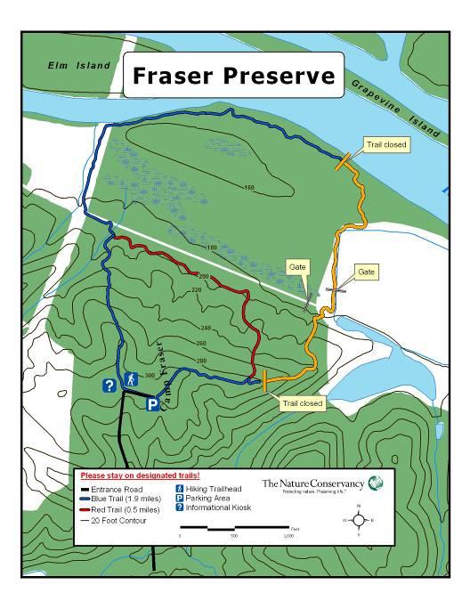
2 TABLE OF CONTENTS Chapter Page I. Volunteer Position Description 3 II. Preserve Information...5 Guide to the Preserve Public Access Issues and Violations: What to look for/ Action to take Policies and Procedures Proper Preparation III. Monitoring Inspection Report Form.8 IV. About The Nature Conservancy..9 Mission Facts and Figures Frequently Asked Questions The Nature Conservancy in Virginia V. Safety.. 11 Emergency Procedures and Guidelines VI. Additional Resources..12 Contact Information Preserve Map Mary Porter/ Fraser Preserve THANK YOU for deciding to help maintain and monitor Fraser Preserve. Volunteers make it possible for the Conservancy to continue protecting nature and preserving life. 2
3 VOLUNTEER POSITION DESCRIPTION POSITION TITLE: POSITION LOCATION: SUPERVISOR: Volunteer Visitation Committee Member Fraser Preserve, Fairfax County Volunteer Coordinator SUMMARY: With many preserves to manage around the commonwealth, it is not always possible to monitor them as often as the Conservancy would like. Regular monitoring and maintenance keeps us informed about their condition, while promoting the Conservancy s mission and supporting the ecological goals for which each preserve was established. Committee Members visit the preserve on a rotating schedule, greet visitors, walk trails, make observations and perform trail maintenance as needed while working as part of a team. ESSENTIAL FUNCTIONS: Committee members will visit the Preserve on a regular, rotating calendar schedule, approximately 4-6 visits per year, to assess the condition and needs of the Preserve. When making a visit, members should thoroughly inspect the property by walking trails and various areas of the Preserve while carrying a tool to observe for the following: Instances of trespassing and land abuse (trash dumping, unauthorized trail use, etc.). Condition of the parking areas, gates, kiosks, signs, trails and boundaries (vandalism, tree blow downs, erosion damage, etc.) Volunteer Visitation Committee Members should also perform basic trail maintenance by removing debris, fallen branches, overgrown vegetation and trash as needed. Members will report problems and issues to the supervisor. BASIC QUALIFICATIONS: - Demonstrated interest in the management of nature preserves and commitment to the mission of The Nature Conservancy. - Basic physical fitness to hike moderately challenging outdoor terrain and physical ability to operate hand tools such as loppers and hand saws safely. - Good human interaction and interpersonal communication skills to work and communicate with a diverse group of people, including volunteers, local residents, trespassers if necessary and Conservancy staff. - Self transportation to and from site. - Willingness to participate in training sessions and attend committee gatherings (potlucks, etc.) - Enthusiasm and ability to work as part of a team. 3

4 RELATED RESPONSIBILITIES: - Complete and report preserve inspection form after preserve visits (provided by The Nature Conservancy). - Suggest ideas for improvement projects to accommodate future preserve needs. - As needed, greet and inform visitors of rules and volunteer preserve opportunities. - When possible, help establish and maintain good relations with preserve neighbors and foster local attitude of stewardship, possibly recruiting volunteers to assist with future work. COMMITMENT: Flexible, depends on personal interest in maintaining preserve; ideally, 4-6 days per year or more. Ultimate goal is to have the preserve visited every week by committee members. BENEFITS: Being a Volunteer Visitation Committee Member for The Nature Conservancy gives you the opportunity to help protect critical habitat for plants and animals that is quickly disappearing. Members will gain valuable experience in the field and have the opportunity to increase leadership skills. TNC/ Fraser Preserve 4
5 PRESERVE INFORMATION GUIDE TO THE PRESERVE Fraser Preserve is a 220 acre nature preserve located on the border of Fairfax and Loudoun Counties on the Potomac River. The Preserve boasts about 110 species of birds, including the bald eagle, and 300 varieties of wildflowers. A short hike offers glimpses of the many natural habitats found in the Piedmont region, including clear fast streams, lush cold-spring swamp, marsh, mature hardwood forests, open meadow, ponds, river and stream floodplain forests and thickets, steep rocky bluffs, springs and seeps, and various stages of old field succession. Fraser Preserve was acquired in 1975, as a gift from Mrs. George (Bernice) Fraser. Originally inhabited by members of the Anacostan, Piscataway and Tauxenent tribes, the bottomlands along Fraser's river border have yielded many Indian arrowheads, pottery shards and stone weirs (dams used in taking fish from the Potomac). These historic sites were studied extensively by American University, and the artifacts discovered are displayed in their museum. The area now known as Fraser Preserve was once part of a tract of five million acres granted by King Charles I in 1649 to seven nobleman friends. In 1710, the land was passed on to the Fairfax family and eventually to Thomas Lee, the first of the famous Virginia Lees. Wheat farming prevailed in the area from about 1790 to 1840, and it is likely that the tract was farmed until post-world War I times when agriculture declined in Fairfax County. Mrs. Fraser also donated a small in-holding within the preserve to the Calvary Baptist Church. The Conservancy and the Calvary Baptist Church share the common goal of maintaining Fraser Preserve in its natural state. PUBLIC ACCESS Nature Conservancy preserves are private properties. They are managed to protect fragile resources--native species and plant communities. The point of allowing the public to visit the property is to educate and inspire. During defined hours, the public are permitted to park in the gravel lot at the entrance and enter the preserve on foot using designated trails. The 2.25 mile walking trail meanders to the river and trails within the preserve connect with public paths on land owned by the Northern Virginia Regional Park Authority. An information kiosk and trail map are located on the preserve to orient and educate visitors of the opportunities that are available as well as list the rules and policies of the preserve. Specific hours, rules and policies are as follows; The preserve s trails will be open to the public daily, dawn until dusk, year round. Prohibited activities include: camping, fishing or trapping, horseback riding and biking except on the section of trail along the river, hunting, motorized travel, pets and the collection of plants, animals, artifacts or other items found on the preserve. 5
6 WHAT TO LOOK FOR/ ACTION TO TAKE Note the condition of the preserve s natural features, signs, trail markers, structures, as well as anything unusual. Please fill out the Monitoring Inspection Report Form, example found on page 8, and turn in to supervisor. Parking Areas/ Signs/ Kiosks/ Structures/ Gates (locks) Most Conservancy parking areas are small in size and simply just a pull-off from the road. Check parking areas for litter or dumped garbage or overgrown vegetation. Check the condition of gates or fences that may need replacing and check for damage to kiosks and signs. ACTION: Pick up any litter or dumped garbage (if substantial amount, may need to schedule a workday). Mow, week-whack or trim with hand tools any overgrown vegetation adhering to all safety precautions. Contact supervisor with any structure issues. Trails Survey the condition of all trails. Look for blow downs, obstructions and erosion problems. Inspect for encroaching vegetation. Make sure the trail markers are present or in need of replacement. ACTION: Remove any overgrown vegetation with hand tools such as loppers, clippers or swing blades. Maintain a path that is 4 wide by 7 tall to allow easy passage. Walk trails and move any blow downs and obstructions such as branches and fallen trees out of the trail while adhering to all safety precautions. Do not move large trees or those that need chainsaw work. Contact the Conservancy staff if chainsaw work is needed. Replace trail markers as needed. Contact supervisor with any boardwalk or bridge damage that you cannot repair. Signs of: Vandalism, Dumping, Fire, Unauthorized vehicle activity (ATV s), Trespassing, Illegal Hunting, Camping, *Biking, *Horseback Riding, Damaged Vegetation, etc. *note: Biking & Horseback riding is permitted on the section of trail along the river. Be aware of instances of the above preserve violations. Look for signs such as tire/track marks, campfires, etc. ACTION: Although committee members have the authority to inform visitors of rule violations, this is not required. Committee members should only act if they feel comfortable. If you witness illegal activity, please do not confront the person, but record the activity and immediately call The Nature Conservancy s office or the Fair fax County Sheriff s office when appropriate. *see additional resources section for important phone numbers 6

7 Pets The Nature Conservancy has a nationwide policy prohibiting pets on preserves. Dogs can chase wildlife, disturb ground nesting birds and trample vegetation. Dogs are very commonly seen with hikers at the preserve. ACTION: Committee members should not ask visitors to leave if they have a dog, but should mention that they are not allowed. However, only speak with visitors if you feel comfortable doing so. POLICIES AND PROCEDURES Reimbursements The Nature Conservancy has certain vendor accounts where supplies can be purchased. However, purchases should be approved in advance by the Conservancy staff in Charlottesville. Many field supplies are kept by this office and efforts should be made to use these whenever possible. Visitor Liability The Nature Conservancy assumes no responsibility for accidents to visitors while at Fortune s Cove Preserve. All visitors to the preserve assume responsibility for their own safety. Preserve Publications All publications should be approved by Conservancy staff at the Charlottesville office. All inquires from newspapers, magazines, television stations, etc. should be forwarded to Conservancy staff as well. PROPER PREPARATION Be sure to dress properly for monitoring. Generally, it is a good idea to wear long pants and hiking or work boots. You should also bring work gloves and water/snacks. Depending on conditions, a hat, sunscreen and insect repellent are helpful as well. Hand tools such as, loppers, clippers, hand saws, swing blades and hoes will also be helpful to remove overgrowth, downed branches and fix sections of trail. Mary Porter/ Fraser Preserve 7
8 MONITORING INSPECTION REPORT FORM SITE: DATE: MONITOR S NAME: APPROX. TIME SPENT IN FIELD: (hrs) If the preserve is in good condition with no significant problems check this box. Was the parking area in good condition along with all signs, kiosks, structures and gates (including locks)? Was the vegetation trimmed around these areas? Comments/Action Taken/ What did you do about it?: Were the trails in good condition? Any blow downs, obstructions, erosion problems? Action Taken/ What did you do about it? What are the conditions of the boardwalks or bridges (if any)? (Loose boards/nails; rotting wood; replacement necessary) Action Taken/ What did you do about it? Were there any signs of (check any that are appropriate): Vandalism Unauthorized vehicle activity Safety Hazards Dumping Biking/Horseback Riding Illegal Hunting Litter Camping Fire Damaged Vegetation Please explain/ What did you do about it?: Did you notice any changes in surrounding land use or status? Describe any interactions you had with preserve neighbors or visitors. Describe any significant wildlife or plant species you may have encountered during your visit. We d like to hear about anything unusual you observed! General Comments. Did you notice any other problems or have suggestions for preserve improvement? 8
9 ABOUT THE NATURE CONSERVANCY MISSION To preserve the plants, animals and natural communities that represent the diversity of life on Earth by protecting the lands and waters they need to survive. FACTS AND FIGURES since 1951 We've protected more than 117 million acres of land and 5,000 miles of rivers worldwide and we operate more than 100 marine conservation projects globally. We have more than 1 million members. We address threats to conservation involving climate change, fire, fresh water, forests, invasive species, and marine ecosystems. We have grown to be one of the nation s top 15 charitable institutions, as measured by private funds raised. FREQUENTLY ASKED QUESTIONS How did The Nature Conservancy get started? The Conservancy emerged from a professional association of ecologists seeking to turn their knowledge of nature into positive action for conservation. The Conservancy was incorporated in 1951 in the District of Columbia for scientific and educational purposes. Where does the Conservancy work? The Nature Conservancy is a global organization that works in all 50 United States and more than 30 countries. How does the Conservancy identify lands and waters for protection? The Conservancy takes a systematic, science-based approach to identifying sites for protection. Called Conservation by Design, this approach helps us identify the highest-priority places landscapes and seascapes that, if conserved, promise to ensure biodiversity over the long term. 9


10 THE NATURE CONSERVANCY IN VIRGINIA Established in 1960 and headquartered in Charlottesville, The Nature Conservancy of Virginia has helped protect more than 235,000 acres of wildlife habitat across the commonwealth. Fraser Preserve is located in Virginia s Piedmont region, home to the Conservancy s first preserve in Virginia. The Piedmont region spans the state from north to south. Its cultural and historical sites include the University of Virginia and the homes of presidents Thomas Jefferson (Monticello), James Madison (Montpelier), and James Monroe (Ash Lawn-Highland). Rolling hills, fertile working farms, expansive river systems, and hardwood forests comprise this densely populated plateau connecting the Blue Ridge Mountains to the coastal plain. To date, the Conservancy has protected more than 23,000 acres and more than 100 miles of streams in the Piedmont, one of the nation s fastest growing regions. Many significant natural areas here still need protection, including 22 examples of large native forests and five river systems spanning 2.6 million acres. Using various creative strategies, the Conservancy is working with partners to conserve the Piedmont s finest remaining lands and waters before they disappear. TNC/ Fraser Preserve Volunteers 10
11 SAFETY EMERGENCY PROCEDURES AND GUIDELINES * see additional resources section for important phone numbers ASSESS THE SITUATION In the event of any accident that requires the immediate attention of medical personnel, call 911. Be advised that cell phone coverage varies. If you need to call emergency services note the following: Know the directions to the trailhead closest to where you are. Take notes about the situation: names, what happened, in what way the victim appears to be hurt, etc. Use from a first aid kit only what you are trained to use. If the injury does not warrant immediate medical attention, the person(s) injured should be transported to the nearest hospital. After you have assessed the situation and dealt with the emergency, please call the Conservancy s volunteer coordinator. POTENTIAL HAZARDS Exposure to rain, wind, cold Exposure to sun, dehydration Terrain including wetland/aquatic habitats Dangerous flora and fauna (e.g., poison ivy, snakes, bees) TOOL SAFETY Carry tools with sharp edge pointed towards the ground on the downhill side of the body when walking. Maintain a safe distance from others when hiking and carrying tools. Make sure area is clear of people before swinging a tool. Notify others if walking behind them when they are using a tool. Keep unused tools away from work area. Lay tools sharp end down. Keep tools closed or sheathed when not in use. 11
12 ADDITIONAL RESOURCES CONTACT INFORMATION The Nature Conservancy in Virginia 490 Westfield Road Charlottesville, Virginia (434) (434) fax Jennifer Rich, volunteer coordinator (434) (office) (740) (cell) Fairfax County Sheriff s Office 4110 Chain Bridge Road Fairfax, VA (434) Reston Hospital Center 1850 Town Center Parkway Reston, VA Ivan Striženec, Camp Fraser Caretaker Calvary Baptist Church (703) istrizenec@calvarydc.org 12
13 13
Fortune s Cove Preserve
 Fortune s Cove Preserve Committee Handbook Michael Lipford Volunteer Visitation Committee Members TABLE OF CONTENTS Chapter Page I. Volunteer Position Description 3 II. Preserve Information...5 Guide to
Cumberland Marsh Preserve
 Cumberland Marsh Preserve Committee Handbook Michael Lipford Volunteer Visitation Committee Members TABLE OF CONTENTS Chapter Page I. Volunteer Position Description 3 II. Preserve Information...5 Guide
Falls Ridge Preserve. Committee Handbook. Volunteer Visitation Committee Members. Michael Lipford
 Falls Ridge Preserve Committee Handbook Michael Lipford Volunteer Visitation Committee Members TABLE OF CONTENTS Chapter Page I. Volunteer Position Description 3 II. Preserve Information...5 Guide to the
What are you getting into?
 Overnight Camping What are you getting into? You will be hiking with your gear to a campground about ½ mile away and spending 1 night camping You will help to prepare a meal over an open flame You will
General Rules for Use of Lands Managed by the. Middle Peninsula Chesapeake Bay Public Access Authority
 General Rules for Use of Lands Managed by the Middle Peninsula Chesapeake Bay Public Access Authority As a visitor to lands managed by the Middle Peninsula Chesapeake Bay Public Access Authority (PAA),
Canal Steward Program Adoption Package
 National Park Service U.S. Department of the Interior Chesapeake and Ohio Canal National Historical Park 1850 Dual Highway, Suite 100 Hagerstown, MD 21740 301-745-5810 phone 301-739-6179 fax Canal Steward
Adopt a Trail Blue Ridge Parkway
 Adopt a Trail Blue Ridge Parkway THANK YOU Thank You for volunteering to maintain a trail with the Adopt-A-Trail program! You are helping to keep these trails open for public use and enjoyment. We couldn
When is Coulee Clean-Up? Starts Earth Day (April 22) through May 31; although you can complete a clean-up at any time of year!
 through May 31; although you can complete a clean-up at any time of year!") 1 What is Coulee Clean-Up? Coulee Clean-Up is a volunteer conservation project coordinated by the Helen Schuler Nature Centre aimed at preserving and protecting the environment of the Lethbridge river
1 What is Coulee Clean-Up? Coulee Clean-Up is a volunteer conservation project coordinated by the Helen Schuler Nature Centre aimed at preserving and protecting the environment of the Lethbridge river
MAIN LAKE PROVINCIAL PARK
 MAIN LAKE PROVINCIAL PARK PURPOSE STATEMENT AND ZONING PLAN March 2003 MAIN LAKE PROVINCIAL PARK Purpose Statement and Zoning Plan Primary Role The primary role of Main Lake Park is to protect a biologically
OWNED LAND ACTIVITIES REPORT February 2012
 OWNED LAND ACTIVITIES REPORT February 2012 BULL RUN MOUNTAINS NATURAL AREA PRESERVE A tremendous number of projects are underway on the Preserve. Currently VOF is working with the Smithsonian Conservation
Green Legacy. Securing our. Greenlands Strategy
 Greenlands Strategy Securing our Green Legacy Together we can create an interconnected network of Greenlands for the health and well-being of the environment and future generations Caring for the Credit
MORGAN CREEK GREENWAY Final Report APPENDICES
 APPENDICES MORGAN CREEK GREENWAY Appendix A Photos of Existing Conditions in Trail Corridor Photos of existing conditions Main trail corridor - February 2009 Photos of existing conditions south bank Morgan
Little Grand Canyon near Pomona, Illinois
 Little Grand Canyon near Pomona, Illinois Below: View of the trail and the terrain created using the Map My Hike app Below: Summary of the hike created using the Map My Hike app Presented by: Jennifer
Nov. 19 th Public Workshop Summary
 On November 19 th, more than 60 community members attended an Open Space Matters workshop at the Linen Building in downtown Boise for over two hours. Participants learned about reserves, discussed the
Mt. Hood National Forest
 United States Department of Agriculture Forest Service Mt. Hood National Forest Zigzag Ranger District 70220 E. Highway 26 Zigzag, OR 97049 503-622-3191 Fax: 503-622-5622 File Code: 1950-1 Date: June 29,
Stephens State Park Trails
 TRAILS OF ALLAMUCHY MOUNTAIN & STEPHENS STATE PARKS Allamuchy Mountain and Stephens State Parks contain 28 marked trails providing access to diverse landscapes for walking, hiking, biking, bird-watching,
List of Challenges. Draw a Map of Your Hike
 List of Challenges Junior Ranger Wildlife Adventures Draw a Map of Your Hike Explore Pella Crossing Hey kids! Do you love animals as much as the Boulder County Park Rangers? Join us on Saturday, June 2
Stephens Rd. Nature Preserve
 Stephens Rd. Nature Preserve History Stephens Road Nature Preserve (SRNP) is a 350-acre nature preserve in Huntersville that comprises nine properties purchased between 1994 and 2008. Parcels included
Kit Carson-Challenger Ridge Trail Project
 Kit Carson-Challenger Ridge Trail Project Project Accomplishments Report-USFS December 15, 2015 Photo courtesy of Justin Peterson 815 South 25 th Street, Suite 101 Colorado Springs, CO 80904 Dedicated
CARVER S FALLS. Cumberland County s Natural Beauty. What s Included In This Information Packette
 Cumberland County s Natural Beauty What s Included In This Information Packette History of the Falls Boy Scouts have acquired Right of Use Guidelines for Usage Application Check-out Report HISTORY AND
FINAL TESTIMONY 1 COMMITTEE ON RESOURCES UNITED STATES HOUSE OF REPRESENTATIVES. July 13, 2005 CONCERNING. Motorized Recreational Use of Federal Lands
 FINAL TESTIMONY 1 STATEMENT OF DALE BOSWORTH CHIEF Of the FOREST SERVICE UNITED STATES DEPARTMENT OF AGRICULTURE Before the SUBCOMMITTEE ON FORESTS AND FOREST HEALTH And the SUBCOMMITTEE ON NATIONAL PARKS,
MASTER PLAN EXECUTIVE SUMMARY
 Biscuit Run State Park Scottsville Road (State Route 20) Charlottesville, VA 22902 Biscuit Run State Park MASTER PLAN EXECUTIVE SUMMARY Department of Conservation and Recreation Division of Planning and
Other Agencies and Organizations
 Daniel Boone National Forest 1700 Bypass Road WInchester, KY 40391 859-745-3100 Location Northern terminus is near Morehead, Kentucky. Southern terminus is located in the Big South Fork NRRA in Tennessee.
Chapter 6: POLICY AND PROCEDURE RECOMMENDATIONS
 Chapter 6 POLICY AND PROCEDURE RECOMMENDATIONS FOR SRRA Below are seven policy elements that should be considered for adoption by the Southwest Regional Recreation Authority of Virginia: 1. Develop strategies
Survivor (Lake Version) Activity Plan
 Activity Plan") Survivor (Lake Version) Activity Plan CONTENTS Outcomes... 2 Activity... 2 2.1 Outline... 2 2.2 Equipment... 3 2.3 Communication... 3 2.4 First Aid... 3 People... 4 3.1 Activity Instructor... 4 3.2 School
Survivor (Lake Version) Activity Plan CONTENTS Outcomes... 2 Activity... 2 2.1 Outline... 2 2.2 Equipment... 3 2.3 Communication... 3 2.4 First Aid... 3 People... 4 3.1 Activity Instructor... 4 3.2 School
Lake Wissota Access Locations within the LaFayette Township. By Chad Martin
 Lake Wissota Access Locations within the LaFayette Township By Chad Martin Anson/ Wissota Access Point # 1 Road: 195 th St. Associated Fire Numbers: 13294 Defining Characteristics: Forested from road
Map 1.1 Wenatchee Watershed Land Ownership
 Map 1.1 Wenatchee Watershed Land Ownership Map 1.1 Wenatchee Watershed Land Ownership The Wenatchee watershed lies in the heart of Washington state in Chelan County. Just larger than the state of Rhode
ISLAND PARK MANAGEMENT PLAN AND GUIDELINES
 ISLAND PARK MANAGEMENT PLAN AND GUIDELINES - 2015 Introduction Island Park was a sand dune on the edge of Lake Huron 12,000 years ago. As the lake receded, it left a river channel, the Thunder Bay River.
This Passport: Revised October 20, 2017, EAM # Discovering the Trails of Webster, NY
 This Passport: Revised October 20, 2017, EAM #161923 Discovering the Trails of Webster, NY The Town of Webster invites you to explore and experience our diverse outdoor adventures! Here s your opportunity
Eco Explorer. Steps. Purpose
 Eco Explorer A n eco explorer is a person who investigates environmental issues and works to make positive changes to the environment. In this badge, you ll be an eco explorer as you take a look at different
Site Coordinator Guide
 GGC MAKE A DIFFERENCE DAYS GREAT CANADIAN SHORELINE CLEANUP Site Coordinator Guide Site Coordinator Guide Introduction The Great Canadian Shoreline Cleanup (Shoreline Cleanup) is a joint conservation initiative
When One Size Doesn t Fit All Building Volunteers with a Spectrum of Opportunity
 November 2013 PNTS When One Size Doesn t Fit All Building Volunteers with a Spectrum of Opportunity Claire Miller City of Scottsdale McDowell Sonoran Preserve The Preserve is Born 1991 Citizens form the
Camping (Primitive) Camping (RV) Electrical Potable Water Grill Established Fire Pit Picnic Table
 Camping (RV) Electrical Potable Water Grill Established Fire Pit Picnic Table") Alden - 9th Road River Mile 777 Map: 38.20833, -98.32031 Managing Agency: Kansas Department of Wildlife, Parks & Tourism Nearest Community: Alden, Rice County Kansas Developed Amenities Provided Parking
Alden - 9th Road River Mile 777 Map: 38.20833, -98.32031 Managing Agency: Kansas Department of Wildlife, Parks & Tourism Nearest Community: Alden, Rice County Kansas Developed Amenities Provided Parking
CRAZY HORSE TRAIL GUIDE
 CRAZY HORSE TRAIL GUIDE Abridged Version: July 2016 This is a short form of our interpretive trail guide for the Crazy Horse Trail. The full version of the guide has a more detailed description of the
~ BOY SCOUTS AMERICA"
 ~ BOY SCOUTS OF AMERICA" Sample Agenda-One-Day Training Local Council Considerations... Planning Your BALOOTraining......................... Before ttaetraining.................................. Opening
Cub Scout Day Camp Leader s Guide 2017
 Cub Scout Day Camp Leader s Guide 2017 Cub Scout Day Camp is a valuable activity to help individual pack succeed while balancing recreation and educational opportunities that challenge the scouts to Do
Volunteer Project Report for May 14-20, 2017 Yosemite National Park Volunteer Trip. Executive Summary
 120 Village Square #9, Orinda, California 94563 www.conservationvip.org info@conservationvip.org Tel: (925) 228-5946 A Non-Profit 501c3 Tax Exempt Organization Volunteer Project Report for May 14-20, 2017
Access: The rocky shoreline is only accessible via private property.
 10. Whale Cove Site description: Whale Cove is a small cove fringed by private homes and condominiums with diverse and relatively undisturbed rocky intertidal and subtidal habitat located approximately
Santa Clara South Hills Recreation Park Project Development and Management Plan
 Santa Clara South Hills Recreation Park Project Application for Land for Recreation or Public Purposes, City of Santa Clara, Utah Prepared for: Bureau of Land Management, St. George Field Office 345 East
Logo Department Name Agency Organization Organization Address Information 5700 North Sabino Canyon Road
 Logo Department Name Agency Organization Organization Address Information United States Forest Coronado National Forest 5700 North Sabino Canyon Road Department of Service Santa Catalina Ranger District
2019 DAY HIKE AT IRON MOUNTAIN SATURDAY, JANUARY 19
 WHERE? In Google Maps, paste the following coordinates for Iron Mountain: 32.978215,-116.972593 or CLICK ON THIS LINK. I. Purpose of the Day Hike A. THE WBC Day Hike is a relatively short trail hike to
Rule Governing the Designation and Establishment of All-Terrain Vehicle Use Trails on State Land
 Rule Governing the Designation and Establishment of All-Terrain Vehicle Use Trails on State Land 1.0 Authority 1.1 This rule is promulgated pursuant to 23 V.S.A. 3506. Section 3506 (b)(4) states that an
Preferred Recreation Recommendations Stemilt-Squilchuck Recreation Plan March 2018
 Preferred Recreation Recommendations Stemilt-Squilchuck Recreation Plan March 2018 Below are the recommended recreation ideas and strategies that package together the various recreation concepts compiled
Geocaching Activity Plan
 Geocaching Activity Plan CONTENTS Outcomes... 2 Activity... 2 2.1 Outline... 2 2.2 Equipment... 2 2.3 Communication... 3 2.4 First Aid... 3 People... 3 3.1 Activity Instructor... 3 3.2 School Staff Member
F.O.K.O.S. Friends of Kingston Open Space A GUIDE TO KINGSTON OPEN SPACE
 F.O.K.O.S. Friends of Kingston Open Space A GUIDE TO KINGSTON OPEN SPACE Friends of Kingston Open Space (FOKOS) was formed when a handful of concerned citizens joined together to learn what could be done
Moraine Valley Community College Campus Tree Care Plan Table of Contents
 Moraine Valley Community College Campus Tree Care Plan 2016-2021 Table of Contents I. CAMPUS TREE CARE PLAN PURPOSE:... 1 II. RESPONSIBLE DEPARTMENT... 1 III. THE CAMPUS TREE ADVISORY COMMITTEE... 1 IV.
Station and Volunteer Leader Guide. Virginia District
 Station and Volunteer Leader Guide Virginia District Day Camp 2014 Friends of Onancock School 6 College Avenue Onancock, VA Day Camp Leadership Camp Director Jennifer Corbin (757) 894 7493 Jennifer_miller27253@yahoo.com
Biodiversity is life Biodiversity is our life
 Biodiversity is life Biodiversity is our life Chapter 10 Section 2 Biodiversity at Risk Objectives Define and give examples of endangered and threatened species. Describe several ways that species are
Backpacking and Hiking LEAVE NO TRACE
 Backpacking and Hiking LEAVE NO TRACE Activity Plan Hiking Series ACTpa014 Project Skills: Learn the seven principles of Leave No Trace (LNT) Develop a skit that demonstrates LNT principles Life Skills:
Appendix 1: Best Management Practices For Hang Gliding and Paragliding in Jasper National Parks
 Appendix 1: Best Management Practices For Hang Gliding and Paragliding in Jasper National Parks Name of Best Management Practice Best Management Practices for Hang Gliding and Paragliding in Jasper National
Triangle Land Conservancy Conservation Area Monitoring Report Carolina North
 Triangle Land Conservancy Conservation Area Monitoring Report Carolina North Property Name: Bolin Creek West Conservation Area Date of visit: March 16, 2017 County: Orange Property Type: Restrictive Covenants
TOWPATH MOWING GUIDELINES
 TOWPATH MOWING GUIDELINES 24 September 2007 CONTENTS Introduction Scope and Status of Guidelines Influences on the Guidelines Health and Safety Biodiversity INTRODUCTION Towpath management is a key issue
Subj: POLICY FOR MAINSIDE TRAIL USE AT MARINE CORPS BASE QUANTICO
 UNITED STATES MARINE CORPS MARINE CORPS BASE QUANTICO, VIRGINIA 22134-5001 MCBO 5090.4 B 04 MARINE CORPS BASE ORDER 5090.4 From: Commander To: Distribution List Subj: POLICY FOR MAINSIDE TRAIL USE AT MARINE
Connie Rudd Superintendent, Black Canyon of the Gunnison National Park
 National Park Service U.S. Department of the Interior Black Canyon of the Gunnison National Park and Curecanti National Recreation Area Information Brochure #1 Wilderness and Backcountry Management Plan
West Point Project U.S. Army Corps of Engineers VOLUNTEER VACANCY ANNOUNCEMENT Posted: 1/12/2018
 West Point Project U.S. Army Corps of Engineers VOLUNTEER VACANCY ANNOUNCEMENT Posted: 1/12/2018 Current Volunteer Coordinator: Park Ranger Rebecca Downey Rebecca.m.downey@usace.army.mil 706-645-6113 West
This Passport: Revised October 20, 2017, EAM # Discovering the Trails of Penfield, NY
 This Passport: Revised October 20, 2017, EAM #161922 Discovering the Trails of Penfield, NY The Town of Penfield is fortunate to have a wide variety of natural resources which make for many unique and
LIGHT AIRCRAFT ASSOCIATION
 LIGHT AIRCRAFT ASSOCIATION STRUT SAFETY GUIDELINES These notes provide general guidelines to Strut Safety Officers in respect of safety enhancement at Strut events Struts should create their own specific
TRAILS WHERE TO FIND TRAILS IN NOVA SCOTIA
 TRAILs SIGNAGE Know the Signs............................ 44 WHERE YOU CAN RIDE Roads and Highways........................ 46 Designated Trails........................... 47 Established Trails...........................
Final Recreation Report. Sunflower Allotment Grazing Analysis. July 2015
 Final Recreation Report Sunflower Allotment Grazing Analysis July 2015 Table of Contents Introduction... 3 Affected Environment... 3 Four Peaks Wilderness Area... 3 Dispersed Recreation... 3 Environmental
Travel in. National Parks. Thailand. Green Heart. Department of National Parks, Wildlife and Plant Conservation
 Travel in National Parks Thailand Green Heart Department of National Parks, Wildlife and Plant Conservation National Park The objectives of national parks are protection and conservation of the country
RATTLESNAKE HILL PHILLIPS, HARRIS FARM, LIME KILN & QUARRY
 Town of, MA Trails Map 6a SPLIT ROCK PRIMARY SECONDARY PRIVATE PRIVATE PROPERY STAY ON HEAD FUTURE TO SKINNER (NOT MARKED) 0 miles 0.25 0.250 0.5 Mapbox, Data Odbl, OpenStreetMap contributors primary use
Pembina Valley Provincial Park. Draft Management Plan
 Pembina Valley Provincial Park Draft Management Plan 2 Pembina Valley Provincial Park Table of Contents 1. Introduction... 3 2. Park History... 3 3. Park Attributes... 3 3.1 Natural... 3 3.2 Recreational...
GOLDEN EARS PROVINCIAL PARK
 GOLDEN EARS PROVINCIAL PARK Trail Information as of October 10 th 2015 Do not underestimate the mountainous wilderness of Golden Ears Provincial Park. The combination of rugged terrain and rapidly changing
Summer Camp Policies
 Summer Camp Policies Confirmation After each camper registration is processed, a confirmation letter will be sent. Please review this for correct camp themes and dates. Complete and return the Camper Information
Pinellas County Environmental Lands
 Pinellas County Environmental Lands In addition to traditional parks and recreation facilities, Pinellas County owns and manages a system of environmental lands that provides specialized resource-based
Maggie s Weekly Activity Pack!
 Maggie s Weekly Activity Pack! Name Date Remembering A Great Adventure The Journey of Lewis and Clark It has been two hundred years since Lewis and Clark started their journey across America. In February
Modini Mayacamas Preserves
 Modini Mayacamas Preserves Access The Modini Mayacamas Preserves (MMP) is 3,000 acres of protected wild country in northeast Sonoma County. This packet provides a brief introduction to the land for those
ADOPT-A-TRAIL HANDBOOK A GUIDE TO TRAIL STEWARDSHIP IN RIVERSIDE COUNTY
 ADOPT-A-TRAIL HANDBOOK A GUIDE TO TRAIL STEWARDSHIP IN RIVERSIDE COUNTY TABLE OF CONTENTS Introduction Mission, Vision, Values Program Staff Volunteer Positions Scouting Opportunities Finding Your Trail
Quintessential Rare Plant Site Protected, Forever Celebrating the New Wilsons Lake Conservation Lands
 Quintessential Rare Plant Site Protected, Forever Celebrating the New Wilsons Lake Conservation Lands A hotspot for Canadian endangered species conservation has been protected, forever, in Nova Scotia.
Langton Lake Park Implementation Planning Session One 6 June Attendees signed in
 27 Attendees signed in Meeting summary Following an overview of the Parks and Recreation Renewal Program and the key directions of the Parks and Recreation System Master Plan, meeting participants were
CHIMNEY ROCK ARCHEOLOGICAL AREA
 CHIMNEY ROCK ARCHEOLOGICAL AREA Phone U.S. Forest Service, Pagosa Springs, Colorado at (303) 264-2268 for tour reservations and information SAN JUAN NATIONAL FOREST PAGOSA RANGER DISTRICT, ARCHULETA COUNTY,
The Frank Church River of No Return Wilderness
 ALLIANCE FOR WILDERNESS EDUCATION AND STEWARDSHIP PO Box 2667, Bellingham, WA 98227-2667 Tele: 360-927-1804 Fax: 360-527-9679 bradt@wildernessalliance.org www.wildernessalliance.org STEWARDS OF AMERICA
Côd Canŵio C oeing Co The Canoeing Code
 Côd Canŵio Canoeing Co de The Canoeing Code The Canoeing Code Welsh rivers and lakes offer a variety of high quality canoeing opportunities for people of all abilities. Help preserve this resource for
(Short Listing) DUPUYER ACREAGE, ROCKY MOUNTAN FRONT
 DUPUYER ACREAGE, ROCKY MOUNTAN FRONT") (Short Listing) DUPUYER ACREAGE, ROCKY MOUNTAN FRONT This unique property is located 8½ miles northwest of Dupuyer, Montana and approximately thirty 30 miles northwest of Choteau, Montana. Great Falls
(Short Listing) DUPUYER ACREAGE, ROCKY MOUNTAN FRONT This unique property is located 8½ miles northwest of Dupuyer, Montana and approximately thirty 30 miles northwest of Choteau, Montana. Great Falls
Pupu Rangi Nature Sanctuary. The Volunteer Program
 Pupu Rangi Nature Sanctuary The Volunteer Program www.pupurangi.com a member of The International Ecotourism Society (TIES) version 1.1 The Pupu Rangi Volunteer Program Information Sheet For those that
BRACEVILLE NATURE PRESERVE Introductions History Present Conditions Future Development Plans Implementation Strategies Statistics
 BRACEVILLE NATURE PRESERVE Introductions History Present Conditions Future Development Plans Implementation Strategies Statistics Introduction Braceville Nature Preserve is one of MetroParks largest preserves.
Seasonal Interpretive Ranger
 Position Description Department of Education and Natural Resources Seasonal Interpretive Ranger Early March-end of October position Objective: Seasonal Interpretive Rangers work directly with the Chief
A Guide to Trail Etiquette
 Share Our Trails A guide to Trail Etiquette Page 12 www.garlic.com/~lbha lbha@vfr.net P.O. Box 2326 Loomis CA 95650 Page Sharing Our Trails A Guide to Trail Etiquette NON-PROFIT U.S. POSTAGE PAID Loomis,
Conservation Area Management Statement
 Conservation Area Management Statement Miller Creek Wildlife Area Resolution #: Approval: Issue Date: Date of Last Revision: Table of Contents 1. Purpose....... 1 2. Property Description...... 1 2.1. Legal
Central Cascades Wilderness Strategies Project
 Central Cascades Wilderness Strategies Project Wilderness is Unique What makes designated Wilderness different from other national forest lands? Wilderness Act of 1964 to assure that an increasing population
Beavers busy damming Cumberland Land Trust property
 Valley Breeze, August 6, 2015 Beavers busy damming Cumberland Land Trust property Cumberland Land Trust director Frank Matta points out the beavers' handiwork on the Great White Cedar Swamp trail off Nate
Backpacking Merit Badge Workbook
 Merit Badge Workbook This workbook can help you but you still need to read the merit badge pamphlet. The work space provided for each requirement should be used by the Scout to make notes for discussing
Proposal to Redevelop Lower Kananaskis River-Barrier Lake. Bow Valley Provincial Park. Frequently Asked Questions
 Proposal to Redevelop Lower Kananaskis River-Barrier Lake Bow Valley Provincial Park Frequently Asked Questions What is being proposed? What are the details of the proposal? Where is the project area located?
Outdoor Skills Patch Program
 Overview The is a progressive, six-level program to help Girl Scout Daisies through Ambassadors learn and become proficient in outdoor skills. Through this patch program, girls explore leadership, build
Yard Creek Provincial Park. Management Plan
 Yard Creek Provincial Park Management Plan Draft January 2010 Yard Creek Provincial Park Management Plan Approved by: telàlsemkin/siyam/chief Scott Benton Bill Williams Squamish Executive Director ation
City of South Lake Tahoe Volunteer Camp Host Handbook
 City of South Lake Tahoe Volunteer Camp Host Handbook January 2018 1 Purpose This handbook is a Camp Host Program outline for Campground by the Lake in South Lake Tahoe. The handbook serves as a go-to-guide
Non-motorized Trail Plan & Proposal. August 8, 2014
 Town of Star Valley Ranch, Wyoming and the Star Valley Ranch Association in partnership with the USDA Forest Service, Bridger-Teton National Forest, Greys River Ranger District Non-motorized Trail Plan
Blueways: Rivers, lakes, or streams with public access for recreation that includes fishing, nature observation, and opportunities for boating.
 Parks, Open Space and Trails PRINCE WILLIAM COUNTY 2008 COMPREHENSIVE PLAN TRAILS PLAN CONTENTS The components of the trails plan are: Intent Definitions Goals, Policies, and Action Strategies Trails Map
Port Gamble Shoreline Area Conceptual Trail Proposal
 The North Kitsap Trails Association is pleased to be a partner to the Kitsap Forest and Bay Project and assist Kitsap County, Forterra, Olympic Property Group, Great Peninsula Conservancy and the Port
Site description: 2.7 miles of intertidal habitat located about 2 miles north of Depoe Bay in Lincoln County, Oregon (Figure 16).
.") 8 Boiler Bay Site description: 27 miles of intertidal habitat located about 2 miles north of Depoe Bay in Lincoln County, Oregon (Figure 16) Designation: Boiler Bay was a research reserve before TSP publication,
8 Boiler Bay Site description: 27 miles of intertidal habitat located about 2 miles north of Depoe Bay in Lincoln County, Oregon (Figure 16) Designation: Boiler Bay was a research reserve before TSP publication,
Saturday Hike - Hancock Loop & Out
 AMC August 3, 2015 Saturday Hike - Hancock Loop & Out 0 2487 ft 2007, Appalachian Mountain Club. All rights reserved. Notes Created by AMC White Mountain Guide Online wmgonline.org 1 Distance Time Elev
Bob Marshall Wilderness Foundation
 About the Bob Marshall Wilderness Complex Considered by many to be the crown jewel of the wilderness preservation system, the Bob Marshall Wilderness Complex located in Northwestern Montana, is the third
Rouge Park Trail and Park Volunteers Orientation Package
 Rouge Park Trail and Park Volunteers Orientation Package In this package you will find: Welcome! Introduction to Rouge Park Introduction to the HAVE Program The Guided Walks and Ambassadors programs; part
Potomac Gorge. Resource Booklet. A Natural Monument in the Shadow of National Monuments. Bridging the Watershed. Potomac Gorge 75
 Potomac Gorge Potomac Gorge A Natural Monument in the Shadow of National Monuments Resource Booklet Bridging the Watershed An outreach program of the Alice Ferguson Foundation in partnership with the National
Attendance Presentation
 TO The Community of Saanich FROM District of Saanich DATE January 30, 2017 RE Meeting Notes Haro Woods Jan 28th Community Engagement Goward House, 2495 Arbutus Road, Victoria BC Attendance In total, 18
St. Christopher Camp and Conference Center s Outdoor education program for elementary and middle school students
 St. Christopher Camp and Conference Center s Outdoor education program for elementary and middle school students Since 1980, The Barrier Island Environmental Education Program has provided thousands of
LESSON 9 Recognizing Recreational Benefits of Wilderness
 LESSON 9 Recognizing Recreational Benefits of Wilderness Objectives: Students will: study, analyze, and compare recreation visitor days (RVD s) for Wilderness areas adjacent to their homes or nearest state,
STOWER SEVEN LAKES STATE RECREATION TRAIL POLK COUNTY, WISCONSIN. MASTER PLAN June, 2018
 STOWER SEVEN LAKES STATE RECREATION TRAIL POLK COUNTY, WISCONSIN MASTER PLAN June, 2018 Polk County Environmental Services Committee Kim O Connell-Chairman Brad Olson -Vice Chairman Jim Edgell Doug Route
Arrival and Check In
 Dear Cub Scout Leaders and Parents, First, we would like to thank you for all you do in Scouting, volunteering, and bringing your Scouts to summer camp. We hope you find that each year, your Pack can come
Vancouver Airport Authority. Contractor Safety Management Program [CSMP] Airside Contractor & Construction Safety
![Vancouver Airport Authority. Contractor Safety Management Program [CSMP] Airside Contractor & Construction Safety](/thumbs/81/83688158.jpg "Vancouver Airport Authority. Contractor Safety Management Program [CSMP] Airside Contractor & Construction Safety") Vancouver Airport Authority Contractor Safety Management Program [CSMP] Airside Contractor & Construction Safety - 2017 CSMP Contractor Expectations - 2017 i Contents Contents Contents Introduction ii
Vancouver Airport Authority Contractor Safety Management Program [CSMP] Airside Contractor & Construction Safety - 2017 CSMP Contractor Expectations - 2017 i Contents Contents Contents Introduction ii