HISTORY OF THE LAKES NEAR LAPORTE, INDIANA.
|
|
|
- Bruno Woods
- 6 years ago
- Views:
Transcription


1 Lakes Near Laporte 83 HISTORY OF THE LAKES NEAR LAPORTE, INDIANA. W. M. Tucker, Indiana University. In October, 1921, the writer's attention was called to the recession of the lake level in the vicinity of LaPorte, Indiana, by an appeal from the Park Board of LaPorte to the State Conservation Commission for suggestions as to the cause of the recession and means of raising the lake level. Since that time I have spent about three weeks in the field about LaPorte and have found a peculiar and very interesting problem. On my first visit to LaPorte I was accompanied by Prof. Will Scott of the Zoology Department of Indiana University and on my third and last visit I was assisted by Mr. W. A. Thomas, a student of Geology at Indiana University. I wish to acknowledge the services and suggestions of these men and also Mr. Maurice Fox, President of the Park Board of LaPorte; Dr. W. N. Logan, State Geologist; Mr. Burtis Thomas, City Engineer of LaPorte; Mr. Robert Day, Assistant City Engineer; Mr. W. A. Cummings, Park Superintendent of LaPorte; Messrs. J. W. and Archie Good, well drillers of LaPorte and many others whose suggestions and services were of value. PHYSIOGRAPHY AND GEOLOGY OF LAPORTE COUNTY. The physiographic conditions of LaPorte County are dominated by the influence of the Wisconsin glaciation. Mantle rock derived from glaciation overlie the Devonian limestones and shales to a depth of 100 to 250 feet or more. There are no bed rock exposures in LaPorte County. By reference to figure 1, the type of surface rock are evident. The southeastern 60.1 per cent of the county is an old lake flat. It is now called the Kankakee valley or Kankakee lowland. This legion slopes gently toward the south from an elevation of somewhat less than 800 feet on the north to the Kankakee River somewhat above 700 feet on the south. The average slope of this region is about five feet per mile. Gravels and sands on the north merge into finer sands, clays and peat on the south. Great areas along the Kankakee were covered by swamp until recent drainage projects have reduced them materially. Considerable swamp land still prevails, however. Lying northwest of this lake flat is the great Valparaiso moraine. This area comprises 29.6 per cent of the county. The crest of this moraine is represented in general by the divide on figure 1 and that part lying north and west of LaPorte is shown accurately. This crest is undulating reaching elevations about 950 feet and seldom reaching lower elevations than 900 feet. The south margin of the moraine has an elevation of about 800 feet, usually slightly less. The north margin has an elevation of from 650 to 680 feet. Thus the north slope is much steeper than the south slope. The surface of this moraine is of the knob and basin character typical of well developed morainic regions. The north slope is undergoing severe stream erosion where the tributaries "Proc. 38th Meetins-, 1922 (1923)."

 of LaPorte County, Indiana, showinpr glacial deposits and (it hoi- data.")

2 84 Proceedings of Indiana Academy of Scie^ice of Trail Creek have invaded it. The south side has a few small streams which empty into swamps or small lakes but the tributaries to the Kankakee have not invaded this morainal area. The Little Fi.!?. 1. Mai) of LaPorte County, Indiana, showinpr glacial deposits and (it hoi- data. (After Leverett.) Kankakee, east of LaPorte, is an exception to this rule. It rises in a glacial stream valley which lies within the moraine. The moraine is composed of sand and gravel with occasional lenses of clay. According


3
4 ^


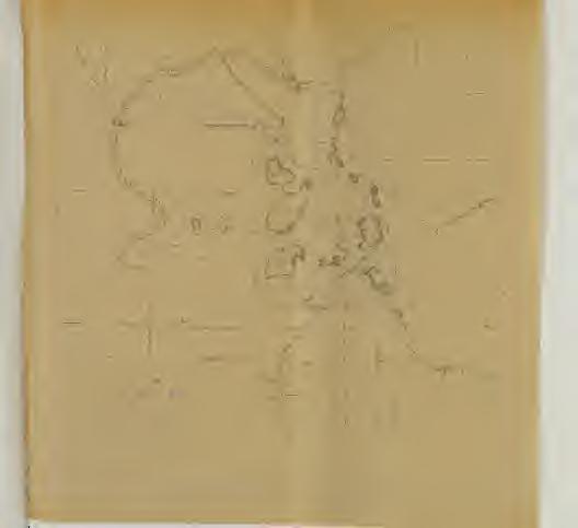
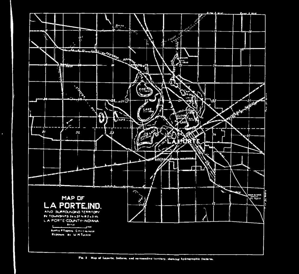
5 Lakes Near Laporte 85 to Mr. Leverett^ this moraine is predominately clay west of Valparaiso and sand and gravel east of that point. Four other small areas lie to the northwest of the Valparai-so moraine in LaPorte County. These are a belt of outwash about two miles wide comprising 3.9 per cent of the county, small patches of moraine comprising 1.8 per cent, a lacustrine plain, part of the bed of Lake Chicago comprising 2.8 per cent and a part of Lake Michigan comprising- 1.8 per cent. Sand dunes have encroached upon much of the land portions of these areas. Since these areas have little to do with the problem of the LaPorte lakes they will not be discussed in detail. Origin of Lakes. Three types of lakes occur in LaPorte County. Those which lie in the Kankakee lowland are lemnants of the great marginal lake which once occupied this area. Those which lie within the Valparaiso moraine are principally of the irregular type of lake which occupy the irregular depressions left by glacial deposit. There are probably some kettle hole lakes which are formed by melting of buried masses of ice within the moraine. This type of lake is small, nearly circular and deep. They are usually closely associated with the irregular type and are sometimes hard to distinguish from them. The group of lakes which lie west and north of LaPorte are of the irregular type. The group of lakes of which this paper treats specifically form a crescent partially within the city limits and partially on the northwest edge of the city. The limbs of the crescent point north and beginning with the northeasternmost lake we find, Lower, Clear, Lily, Stone, South Pine and North Pine, the last forming the northwest limb. On the northeast limb to the north of Lower Lake are three other small lakes, Lower and Upper Fishtrap and Horseshoe Lakes. These three lakes, however, are detached from the other groups by considerable divides and ^ lie at considerably different levels so are treated only incidentally in this paper. Status of Lakes at Earliest White Settlement. The six lakes named in the first group above are remnants of two lakes which existed when white settlers first came to this region. Lower, Clear, Lily and Stone lakes were then i^arts of one lake the extent of which is shown in figure 2. The elevation of this lake was about thirteen feet higher than the present level of Clear Lake or about 804 feet above sea level. The two Pine lakes were united at that time and the extent of this lake is shown in figure 2. The elevation of this lake was about twenty feet higher than the present level of North Pine Lake or about 809 feet above sea level. The divide between these two lakes was a low narrow ridge through which a channel was cut to allow the passage of a small steam boat. This boat was used to convey passengers from LaPorte to the Old Baptist Assembly ground on the north end of North Pine Lake where Pine Lake Village now stands. This steamer discontinued operation about forty years ago. During these early years Clear Lake had an outlet overland through the city of LaPorte somewhat north of the business section. This outlet ceased to flow forty or fifty 1 Monograph IJII, U. S. Geol. Suiv.


6 43 86 Proceedings of Indidna Academy of Science years ago according to the testimony of early settlers. Thus the decline of the lakes began long ago. However, the old shore lines, with their small terraces and small wave-cut cliffs, on which stand large trees whose lake side roots are deformed by ice and wave action, remain as mute testimony to the survey of 1829 when the extent of these lakes v.'as as shown in figure 2. Relation of Original Lakes to Present Lakes. Since the overland channel of Clear Lake has been closed the entire drainage of these lakes has been underground. A survey of 1847 shows the area of the lakes very greatly reduced from that of 1829 and the area at present is much smaller than that of The areas of the two lakes shown by the suivey of 1829 and the areas of their present remnants as determined by planimeter from figure 2 are as follows: North Lake of sq. mi. North Pine Lake.167 sq. mi. South Pine Lake. 275 sq. mi. Total.442 sq. mi. Per cent of former lake 81. South Lake of sq. mi. Stone Lake.196 sq. mi sq. mi. Lily Lake.020 sq. mi. Clear Lake Lower Lake.035 sq. mi. Total.386 sq. mi. Per cent of former lake 29. From this we find that the areas of the two original lakes were very near the same and that the present remnants are not far different from each other, each representing about 30 pei- cent of the original. The levels of the remnants are fairly uniform. It is interesting that / North Pine Lake is the lowest of the gi'oup and each lake of the crescent is slightly higher until Lower Lake at the other end of the crescent which is the highest. The following figures show the elevations of the various lakes as determined by Burtis Thomas, City Engineer of LaPorte, in December, 1921, and my own check en North Pine and Clear lakes in June, 1922, during a severe drought: Lower Lake feet (Thomas) Clear Lake feet (Thomas) feet (Check) Lily Lake feet (Thomas) Stone Lake feet (Thomas) South Pine Lake feet (Thomas) North Pine Lake feet (Thomas) feet (Check) Figure 3 shows the elevation of Lily Lake from 18i)8 to 1914, inclusive. The record of the lake level was kept by the city waterworks employes for each day during this period. The elevation indicated for any year on this graph was derived by averaging the level readings for the first day of each month during the year. The monthly fluctuations were slight so that this gives a comparatively accurate elevation for the year. To convert these readings to the datum of sea level add feet. This graph shows that Lily Lake fluctuated in this period


7 Lakes Near Laporte 87 between low level of feet (791.74) in 1901 and high level of 33 feet (795.32) in At the beginning of the period the lake stood at feet and at the end at feet. The average for the whole time was feet. These elevations compared with the elevation of feet late in 1921 shows a decline of less than two feet since Thus the general decline in Lily Lake has been comparatively small since 1898 if the records are all correct. Records upon other lakes are not available except occasional records upon Clear Lake which have been kept by Mr. W. A. Cummings, Park Superintendent, who asserts that Clear Lake has declined five feet or more in the last eight years. Relation of Lakes to Ground Water Tabic. This group of lakes has no inlets except sheet drainage of very small areas and has no outlet. Therefore the lake levels are evidently maintained by ground water.


8 SS Proceedings of Indiana Academy of Science TABLE 1. Elevations of low points about Cleai- Lake in relation to the elevation of Clear Lake, and the fall per mile. Point


9 Lakes Near Laporte 89 testimony of citizens as authentic. However, the data on Lily Lake can be considered authentic so far as fluctuation is concerned. The decline of five feet in the level of this group of lakes has greatly reduced its area. By estimate the present area is slightly more than half the area when the lakes stood five feet higher. If we consider that area to have been twice the present area it gives us a working basis to determine the actual loss of water in the ten years. The area of the present lake surface is.828 square mile. The former area if twice as large was square miles. The average area for the ten years has been square miles, which is 34,624,972.8 square feet. The volume on this average area to five feet deep is 173,124,846 cubic feet, the water loss in ten years. Thus, the loss per year has been on the average 17,312,485 cubic feet. This loss has been much more rapid than in the preceding years according to the testimony of citizens and according to the record kept at Lily Lake. While the consistent loss since white settlement of this region can be explained by deforestation and systematic drainage of the land, the increased decline within the last ten years is no doubt due to the installation of the sewage disposal system in the city of Laporte. Apparent Relation of Lake Level to Ground Water Level Prior to Installation of Sewage System. When white settlers came to this region and for a long time thereafter Clear Lake drained eastward through the present city of LaPorte. During that time Clear Lake stood at a lower level than Pine Lake. This is shown by the levels of the old shore lines. Even at that time, however, theie was underground drainage from Pine Lake through the Valparaiso moraine to the springs whose location is shown in figure 1. There is every indication that this drainage existed because of the steep gradient shown in table 1. Some idea of the drainage of the region north of these lakes and no doubt of the lakes themselves may be gained from observations at Harding Pond, Section 22. Considerable areas north of this pond are drained into it by tile drainage, one an eighteen-inch tile. During heavy rains this tile and others flow full into the pond and fill it up to a certain level above which the lake does not rise. Neither is there indication of water entering Pine Lake from this pond. The two are separated by a divide over fifty feet above Pine Lake. The distance from the pond to Pine Lake is about one-half mile and the difference in elevation 10 feet. Thus the gradient from Harding Pond to Pine Lake is 20 feet per mile but the springs north of the moraine are 75 feet lower than the pond and two and one-half miles away. Thus the gradient to the springs is 30 feet per mile. The peculiar topography of this moraine with its abrupt noi-thern slope leaves the whole southern slope perched so high above it that the tendency of the ground water below lake level is to pass beneath the moraine and appear at the springs. There are no large springs on the south side of the moraine. The material of the moraine is principally gravel and sand while that of the Kankakee lowland is fine sand and clay. There is every evidence that there is a deep seated underground drainage even from the Kankakee valley itself toward Lake Michigan.


10 90 Proceedings of Indiana Academy of Science Figure 4 illustrates the general idea. In order to prove this point a well test was made to determine the direction of ground water flow on the north shore of North Pine Lake at the point indicated by the letter W in figure 2. The point selected for the test was located fifty feet from the present lake shore, about five feet above present lake level on the old lake bed. A three-inch well was sunk to a depth of twentynine feet, which brought it to the level of the deepest point in Pine Lake. The deepest point in Pine Lake was 24 feet, located three hundred feet directly out from where the well test was made. Using the three-inch well as a center and a radius of six feet, a circle was described. On this circle at the cardinal and intercardinal points twoinch wells were sunk to the same depth as the three-inch well. The water rose in these wells to various heights from 2.73 to 3.08 feet below lake level. This circumstance proved that the ground water was not moving toward the lake at the surface of the lake. Some of the wells t/77trrm r/rrrrrr'rrttrrt rfrfrmtt rrrr rtt, FiK. 4. Cross-section from middle of section?,, T. 156 N., R. 3 W. northward through Stone and Pine Lakes and Hardini^- Tond. to SprinKville, shnwin.ur probable ;jrround water movements. had clay pockets in the drilling and these wells stood at the highest level. All the wells were in gravel at the bottom. At six a. m., July 4, 1922, the center well was charged with fluoi-- escein, which colors the water a vivid green. Samples were taken from the outer wells each hour during the afternoon. At 7:00 p. m. a faint color was detected in the northwest well which became distinct at 7:15. Thus the ground water at that point was moving northwestward at the rate of six feet in thirteen hours, 11 1/13 feet per day. If this rate is uniform the time necessary for it to travel to the springs north of the divide is almost four years. This is rather rapid for ground water flow but the rapidity is due to the gradient of twenty-two feet per mile and the coarse sand and gravel through which the flow occurs. The result of this test when associated with the fact that the lake levels are successively lower from Lower to North Pine and that there are overland channels which flow from Lily to Stone and from Stone to South Pine part of the year leaves no room to doubt that the principal ground water di'ainage from the lakes is from North Pine northward.


11 Lake^ Near Laporte 91 Springs Between Sprinyville and Balcerspoint. A careful examination of the springs north of the moraine was made. The springs issue from the hill slope in bogs which sometimes cover several acres. Within these bogs the whole surface is filled with water and trembles as one steps upon it. In wet weather it is impossible to walk across them. The highest of these bogs was at an elevation of about 724 feet. From the bogs the water immediately forms a definite stream which flows down a steep slope until it joins Trail Creek. The seven springs shown as tributary to the east fork of Trail Creek (figure 1) discharged on June 22, 1922, cubic feet per second. This measurement was carefully made by weir and calculated by Francis' formula. The western one of these springs was by far the largest and discharged 1.75 cubic feet. No measurements were made on the springs tributary to the west fork of Trail Creek but the two forks are not far from the same size. The measured discharge amounts to 90,181,260 cubic feet per year. From the topography of the region it appears that about twelve square miles drain through the moraine in the vicinity of La- Porte. The discharge of the springs would account for about three and one-half inches of rainfall over this area. Since no measurements were made on the springs on the west fork of Trail Creek that discharge would account for considerable more. Since the rainfall is about thirty-six inches and the run-off usually about 25 per cent to 35 per cent, the amount to be accounted for would be about 9 to 12 inches. Therefore it is evident that these springs account for a considerable percentage of the drainage of this region. Figure 8 has already been discussed to some extent on page 86 of this paper. The rainfall data shown in this graph was taken from reports of the United States Weather Bureau for LaPorte and are referred to inches on the right of the graph. It will be noticed that the lake response to heavy or light rainfall occurs two years later. An analysis of the graph shows an interesting relation. Low rainfall occurs in 1899 and low lake level two years later; high rainfall in 1902 and high lake level two years later; low rainfall in 1904 and low lake level two years later; high rainfall in 1907 and high lake level two years later; low rainfall in 1910 and low lake level two years later. Two slight contradictions to this response occur. A slightly diminished rainfall in 1906 has no corresponding depression of lake level in 1908 and relatively high rainfall in 1911 is not succeeded by high lake level in The latter case can be explained by the fact that the city water was drawn from the lake from July, 1908, to Novem.ber, This fact may also account for the rapid decline of the lake from 1909 to The responses are too regular to be accidental and there must be some cause for it. Hypothesis to Explain Responses of Lily Lake Level to Rainfall. The response of Lily Lake and probably of the whole system to the rainfall cannot be explained by the influence of any condition near at hand. While the actual movement of ground water from the crest of the moraine north of the lakes to them, if such movement takes place, would probably require two years, yet the lise of the water table at that point would show its influence much sooner. It is my opinion that


12 92 Proceedings of Indiana Academy of Science this response comes from a stimulus in the great morainic area of Steuben County and vicinity. Figure 5 shows the general idea. It is an interesting thing that artesian wells occur at many points between Steuben and LaPorte Counties. At South Bend there is a lens of impervious clay as shown in figure 5. A well drilled into the gravel beneath this clay will overflow in the lowlands along the St..Joseph River while a well sunk into the gravel above the clay will not overflow. In other places in this vicinity the same condition exists. The same influence communicated to the bottom of the lake system at La Porte would influence its level. The position of these lakes at the edge of the great clay deposits of the Kankakee lowland would account for the hydrostatic head by which the lake level is sustained slightly above this lowland. The response to the static influence from this great distance would lag far behind the stimulus. I know of no experiment or investigation which has ever been made to determine the rate of response of stimulus from hydrostatic head through rock. No conclusive Fiji. "). Cross-section profile from Lake MichiKan to Lake Erie showing major ground movements as dominated by major relief features. statement as to the cause of the response shown in figure 3 can be made, but as before stated the responses are too definite and persistent to be ignored. Ajjparent Effect of Installation of Storm Sewage System in La- Porte upon the Lakes, ivith Explanation. The storm sewage disposal.system of LaPorte was constructed in The extent of the main lines of this system is shown in figure 2. Laterals extend to all parts of the city along these mains. All that part of the.system' north of the junction of the Fifth Street main with the main sewer line is above the level of Clear Lake. Following the in.stallation of this system there has been a rapid decline in the level of the lake system. As previously stated, Mr. W. A. Cummings, Park Superintendent, has determined this c'ecline to have been about five and one-half feet, in eight years. Because of the coincidence of the beginning of the rapid decline of the lake level with the installation of the sewage system it is apparent that they are related. The soil underlying the city of LaPorte is principally sand and gravel with small amounts of clay. Formerly much of the water which


13 : Lakes Near Laporte 93 fell in the city as rain entered the soil and became ground water. Thus, the water table was held up. After the installation of the sewage system the storm water was drained directly from the streets into the sewers. As a result there was a loss of water to the water table and it declined. Mr. J. W. Good, well driller of LaPorte, stated that he *inds the water table about seven feet lower now than at the time of che installation of the sewer system. He states that the water table is now from twenty-eight to thirty feet beneath the surface of the city. The city bench mark on the court house lawn is at feet elevation. Therefore the water table, according to Mr. Good, is at to feet elevation. If we consider the present water table as being at feet elevation in the business section of LaPorte, seven feet lower than in 1913, and Clear Lake at feet elevation or five and one-hall feet lower than in 1913, we have the following comparison of levels Clear Lake Level Water Table Level Difference feet feet feet feet feet 8.44 feet If we now consider the business section of LaPorte as one-half mile from Clear Lake, we find that the fall of 6.94 feet in the half mile is practically the same as the fall of 13.3 feet per mile toward the city wells (see page 88). By the installation of the sewage system the water table was lowered about Clear Lake, thus steepening the water table slope. This slope is still steeper than it was before the installation of the sewage system, so it may be that Clear Lake will decline further. Since the supply of water to the lakes was not increased when the sewage system was installed and the water table lowered on this side of the lake it serves the same purpose as removing a retaining wall from the side of a pond except that the response is slower due to the very slow movement of the ground water. PropoHed Plans for Restoring Lake Levels. On page 89 the average loss of water per year from the lake system for the last ten years is given as 17,312,485 cubic feet. Any means of restoring the lakes to their former level must therefore furnish at least this much water. Two plans are suggested. The first is to reverse the storm sewage of the city into Clear Lake. All of the system north of and including the Fifth Street sewer could be reversed. The area drained by this part of the system is about two square miles and the annual rainfall on this area slightly more than thirty-six inches. If we consider that the sewers carry away one-tenth of the water which falls within the area drained by them the amount disposed of during the year would be 16,727,040 cubic feet or almost enough to supply the deficiency. Since it is highly probable that much more than one-tenth of the rainfall is disposed of by the sewers and since the average loss per year to the lakes is probably considerably over-estimated, this reversal of drainage would probably be sufficient to prevent a further decline of lake level and also tend to raise the level. A second plan is to drain areas of the morainic area north of the lakes into them. As previously pointed out, there is now little of this area draining into the lakes. However, between the lakes and the crest


14 94 Proceedings of Indiava Academy of Science of the moraine there are about o,500 aci-es which could be drained into the lakes. Three lines of drainage are suggested and shown in figure 2. The eastern line of drainage beginning- in section 14 would drain an area of about 1,000 acres without laterals and possibly half that much more by lateral connections. This drainage introduced into Lower Lake would silt it up and gradually reduce this lake to solid ground, which would be highly desirable, since Lower Lake is now virtually a swamp and nobody is interested in restoring it. This would admit the drainage into Clear Lake virtually free from sediment. The second line of drainage in sections 21 and 22 has already been surveyed by Mr. Thomas, City Engineer of LaPorte. It is proposed by Mr. Thomas to tunnel about 1,600 feet from Harding Pond to Pine Lake. This line of drainage would drain about the same amount of land as the former line. The third line of drainage in sections 20, 29 and 33 would drain a smaller area. The total area drained would be not less than 2,000 acres and if fully developed about 3,500 acres. The slopes along the drainage lines would vary from 30 to 50 feet per mile. The discharge delivered by these drainage lines if properly installed would vary from 25 to 40 per cent of the rainfall. This would be from 9 to 15 inches per year from the ai'ea. If the higher estimate of 15 inches from 3,500 acres is considered the discharge would be 190,575,000 cubic feet per year. If the lower estimate of 9 inches from 2,000 acres be considered the discharge per year would be 65,340,000 cubic feet. Even the lower estimate is 3.7 times the yearly loss of water from the lakes and the result of this drainage would be the immediate restoration of the lakes to higher levels. The result of restoration of the lakes to higher levels would be to increase the ground water slopes from the lakes. In order to determine the amount of this increase we will consider a seven-foot rise in lake level. This would increase the slope from Pine Lake to the springs from feet to feet, an increase of 10.2 per cent. The increase from Clear Lake east to the city wells would be from feet to feet, an increase of 13.5 per cent. Since the movement of ground water depends upon slope and the jjorosity of the rock, and since the porosity would be unchanged, the increase in ground water loss would be from 10.2 to 13.5 per cent. If we consider this to be 12.5 per cent the estimated loss of 17,563,392 cubic feet per year would be increased to 19,758,816 cubic feet. This would still make the estimated discharge to the lakes over three times the estimated loss from them. 1 am sure the loss in this case is over-estimated and the gain under-estimated so that the.se figures are very conservative. Some minor advantages would be derived by carrying out the proposed plans. Considerable areas of fertile land would be drained and made suitable for agricultural purposes along each of the three proposed drainage lines. The water table would be restored under the city of LaPorte which would restore wells to their former levels and also be of great value to the vegetation of the city. Clear Lake, which is now in the last stages of lake existence and rapidly becoming an unsightly swamp, would be made a fine open lake which would add greatly to the health and beauty of the city. 1
GLACIER STUDIES OF THE McCALL GLACIER, ALASKA
 GLACIER STUDIES OF THE McCALL GLACIER, ALASKA T John E. Sater* HE McCall Glacier is a long thin body of ice shaped roughly like a crescent. Its overall length is approximately 8 km. and its average width
GLACIATION. The Last Ice Age (see Chapter 12) and. Pleistocene Ice Cap. Glacial Dynamics 10/2/2012. Laurentide Ice Sheet over NYS
 and. Pleistocene Ice Cap. Glacial Dynamics 10/2/2012. Laurentide Ice Sheet over NYS") GLACIATION and New York State Prof. Anthony Grande The Last Ice Age (see Chapter 1) The Pleistocene Epoch began 1.6 mya. During this time, climates grew colder. There were numerous ice ages starting 100,000000
GLACIATION and New York State Prof. Anthony Grande The Last Ice Age (see Chapter 1) The Pleistocene Epoch began 1.6 mya. During this time, climates grew colder. There were numerous ice ages starting 100,000000
47I THE LAS ANIMAS GLACIER.
 THE LAS ANIMAS GLACIER. ONE of the largest of the extinct glaciers of the Rocky Mountains was that which occupied the valley of the Las Animas river. This stream originates in the San Juan mountains in
Region 1 Piney Woods
 Region 1 Piney Woods Piney Woods 1. This ecoregion is found in East Texas. 2. Climate: average annual rainfall of 36 to 50 inches is fairly uniformly distributed throughout the year, and humidity and temperatures
Gifts of the Glaciers
 Gifts of the Glaciers Gifts of the Glaciers Moving ice of glacier was responsible for water, landforms, and soil characteristics and patterns of today Sculpturing of bedrock materials Glacial Landforms
raft iiii mi.{.i.v mul\ illliiilli 1 : IB I RbBsJKHR Hfffl attwit ttinli
 ; raft iiii mi.{.i.v m I H I mul\ HI illliiilli 111 1 : IB I RbBsJKHR Hfffl attwit...;','-' ffliill IB ttinli URBANA STATE OF ILLINOIS HENRY HORNER, Governor DEPARTMENT OF REGISTRATION AND EDUCATION
PHYSICAL GEOGRAPHY GEOGRAPHY EARTH SYSTEMS COASTAL SYSTEMS FLUVIAL SYSTEMS
 PHYSICAL GEOGRAPHY EARTH SYSTEMS FLUVIAL SYSTEMS COASTAL SYSTEMS PHYSICAL GEOGRAPHY CORRIES / CIRQUES A Corrie or Cirque is the armchair shaped hollow that was the birthplace of a glacier. It has steep,
HYDROLOGY OF GLACIAL LAKES, FORT SISSETON AREA
 PROC. S.D. ACAD. SCI., VOL. 77 (1998) 59 HYDROLOGY OF GLACIAL LAKES, FORT SISSETON AREA Perry H. Rahn Department of Geology & Geological Engineering South Dakota School of Mines and Technology Rapid City,
What Is An Ecoregion?
 Ecoregions of Texas What Is An Ecoregion? Ecoregion a major ecosystem with distinctive geography, characteristic plants and animals, and ecosystems that receives uniform solar radiation and moisture Sometimes
glacier Little Ice Age continental glacier valley glacier ice cap glaciation firn glacial ice plastic flow basal slip Chapter 14
 Little Ice Age glacier valley glacier continental glacier ice cap glaciation firn glacial ice plastic flow basal slip glacial budget zone of accumulation zone of wastage glacial surge abrasion glacial
A trip to Steindalen. - geology and landscape on the way to the glacier. Geoffrey D. Corner
 A TRIP TO STEINDALEN Excursion guide Please take this with you on your trip, but don t leave it behind as litter. A trip to Steindalen - geology and landscape on the way to the glacier A part of Geologiskolen,
A TOPOGRAPHIC FEATURE OF THE HANGING VALLEYS OF THE YOSEMITE.
 A TOPOGRAPHIC FEATURE OF THE HANGING VALLEYS OF THE YOSEMITE. THE larger hanging valleys around the Yosemite valley have topographic features in common that are interesting in themselves, and they likewise
Lidar Imagery Reveals Maine's Land Surface in Unprecedented Detail
 Maine Geologic Facts and Localities December, 2011 Lidar Imagery Reveals Maine's Land Surface in Unprecedented Detail Text by Woodrow Thompson, Department of Agriculture, Conservation & Forestry 1 Introduction
Town of Oakfield Agricultural and Farmland Protection Plan
 SECTION III COMMUNITY OVERVIEW A. Regional Setting / Location The Town of Oakfield is located in the northwestern portion of Genesee County. Located west of New York's Finger Lakes, the Town is uniquely
Specification for Grip blocking using Peat Dams
 Technical Guidance Note 1 Specification for Grip blocking using Peat Dams 1. Introduction Moorland drains (grips) have been dug across much of the Yorkshire upland peatlands. Many of these grips have become
Alpine Glacial Features along the Chimney Pond Trail, Baxter State Park, Maine
 Maine Geologic Facts and Localities September, 2009 Alpine Glacial Features along the Chimney Pond Trail, Baxter State Park, Maine 45 54 57.98 N, 68 54 41.48 W Text by Robert A. Johnston, Department of
3.0 OVERVIEW OF HUECO BOLSON
 3.0 OVERVIEW OF HUECO BOLSON The Hueco Bolson covers about 2,500 square miles, or 1.6 million acres in New Mexico, Texas, and Chihuahua (Figure 3-1). In Texas, the Hueco overlies portions of El Paso and
glacial drift: all deposits associated with glaciation; covers 8% of Earth s surface above sealevel, and 25% of North America
 Glacial depositional features glacial drift: all deposits associated with glaciation; covers 8% of Earth s surface above sealevel, and 25% of North America i) nonstratified drift till: transported & deposited
Geoscape Toronto The Oak Ridges Moraine Activity 2 - Page 1 of 10 Information Bulletin
 About 13,000 years ago as the Laurentide Ice Sheet melted, glacial meltwater accumulated between the ice sheet and the Niagara Escarpment. This formed a lake basin into which gravel and sand were deposited.
Introduction. Implementation of the Village of Capac Master Plan
 Implementation of the Village of Capac Master Plan Introduction The key to a well-planned community is the actual day-to-day use of planning documents, like this Master Plan. Because this plan is to be
Glacial Origins and Features of Long Island
 Glacial Origins and Features of Long Island Interior Coastal Plain Continental Shelf Long Island s Geology 0 Ma Phanerozoic 540 Ma Proterozoic 2500 Ma Archean 3800 Ma Hadean 4600 Ma C M P Geologic Time
MIDDLE SCHOOL CURRICULUM TR AILING ICE AGE M YST ERI E S SEARCHING GLACIAL FEATURES
 MIDDLE SCHOOL CURRICULUM TR AILING ICE AGE M YST ERI E S SEARCHING GLACIAL FEATURES CONTENTS I. Enduring Knowledge... 3 II. Teacher Background... 3 III. Before Viewing the Video... 5 IV. Viewing Guide...
Agenda Report. Spruce Street Outlet Drainage Improvements Tower Road Relief Sewer
 Agenda Report Subject: Prepared By: Spruce Street Outlet Drainage Improvements Tower Road Relief Sewer Steven M. Saunders, Director of Public Works/Village Engineer Date: August 12, 2012 On March 8, 2012
Final Drainage Letter Pikes Peak Community College Downtown Parking Lot Colorado Springs, Colorado
 Final Drainage Letter Pikes Peak Community College Downtown Parking Lot Colorado Springs, Colorado Prepared for: Pikes Peak Community College 5775 South Academy Boulevard Colorado Springs, CO 80906-5422
APPENDIX D: SUSTAINABLE TRAIL DESIGN. APPENDICES Town of Chili Parks and Recreation Master Plan Update
 APPENDIX D: SUSTAINABLE TRAIL DESIGN APPENDICES Town of Chili Parks and Recreation Master Plan Update Sustainable Trail Construction Sustainable trails are defined by the US Forest Service as trails having
The Appleton Wetland; Its Decline, Cause and Recommended Action. Appendix K: Wetland Inspection
 The Appleton Wetland; Its Decline, Cause and Recommended Action Appendix K: Wetland Inspection Report prepared by Appleton Wetland Research Group of the Mississippi Valley Field Naturalists Research Group
1 Glacial Erosion and
 www.ck12.org Chapter 1. Glacial Erosion and Deposition CHAPTER 1 Glacial Erosion and Deposition Lesson Objectives Discuss the different erosional features formed by alpine glaciers. Describe the processes
MIDDLE SCHOOL CURRICULUM TR AILING ICE AGE M YST ERI E S ICE AGE TREKKING
 MIDDLE SCHOOL CURRICULUM TR AILING ICE AGE M YST ERI E S ICE AGE TREKKING CONTENTS I. Enduring Knowledge... 3 II. Teacher Background... 3 III. Before Viewing this Video... 5 IV. Viewing Guide... 5 V. Discussion
Glaciers. Reading Practice
 Reading Practice A Glaciers Besides the earth s oceans, glacier ice is the largest source of water on earth. A glacier is a massive stream or sheet of ice that moves underneath itself under the influence
Chapter 16 Glaciers and Glaciations
 Chapter 16 Glaciers and Glaciations Name: Page 419-454 (2nd Ed.) ; Page 406-439 (1st Ed.) Part A: Anticipation Guide: Please read through these statements before reading and mark them as true or false.
Geomorphology. Glacial Flow and Reconstruction
 Geomorphology Glacial Flow and Reconstruction We will use simple mathematical models to understand ice dynamics, recreate a profile of the Laurentide ice sheet, and determine the climate change of the
c. 1 inch = 0.6 miles e. 1:100,000 f. 1:250,000 f. 1 inch = 4.0 miles
 High School Advance Geology Map Test 2014 Name Use the information on each map to provide the best answer to the questions. Fill in the bubble of the best answer on your answer sheet. Answer questions
Shaping of North America. Physical Geography II of the United States and Canada. The Last Ice Age. The Ice Age. Pleistocene Polar Ice Cap 2/14/2013
 Physical Geography II of the United States and Canada Prof. Anthony Grande AFG 2012 Shaping of North America The chief shaper of the landscape of North America is and has been running water. Glaciation
Glacial Geomorphology Exercise
 James Madison University Field Course in western Ireland Glacial Geomorphology Exercise 3-day road log (abbreviated) Striations Large kame terrace Cirque with moraines Kame delta Striations Eskers Raised
Lynde Creek Watershed. Lynde Creek Watershed CLOCA LYNDE CREEK WATERSHED EXISTING CONDITIONS REPORT CHAPTER 1 STUDY AREA
 Lynde Creek Watershed CLOCA Lynde Creek Watershed CLOCA LYNDE CREEK WATERSHED EXISTING CONDITIONS REPORT CHAPTER 1 STUDY AREA June 2008 TABLE OF CONTENTS 1.0 STUDY AREA... 3 1.1 Lynde Main Subwatershed...6
Massanutten Mountain Cluster
 Massanutten Mountain Cluster Signal Knob Catback Mountain Southern Massanutten Mountain Five areas of almost 49,000 acres on the Lee Ranger District compose the Massanutten Mountain Cluster of Mountain
1.4 Understand how moving ice acts as an agent of erosion and deposition. (Chap. 2)
") 1.4 Understand how moving ice acts as an agent of erosion and deposition. (Chap. 2) There are two types of glaciation. Alpine Glaciation Continental Glaciation Distinguish between the terms alpine glaciation
1.4 Understand how moving ice acts as an agent of erosion and deposition. (Chap. 2) There are two types of glaciation. Alpine Glaciation Continental Glaciation Distinguish between the terms alpine glaciation
READING QUESTIONS: Chapter 7, Glaciers GEOL 131 Fall pts. a. Alpine Ice from larger ice masses flowing through a valley to the ocean
 READING QUESTIONS: Chapter 7, Glaciers GEOL 131 Fall 2018 63 pts NAME DUE: Tuesday, October 23 Glaciers: A Part of Two Basic Cycles (p. 192-195) 1. Match each type of glacier to its description: (2 pts)
Level IV Ecoregions of the Northeast Glacial Lakes Watershed Project Area
 Level IV Ecoregions of the Northeast Glacial Lakes Watershed Project Area Ecoregions are areas having similar ecosystems and environmental resources including geology, physiography, vegetation, climate,
READING QUESTIONS: Glaciers GEOL /WI 60 pts. a. Alpine Ice from larger ice masses flowing through a valley to the ocean
 READING QUESTIONS: Glaciers GEOL 131 18/WI 60 pts NAME DUE: Tuesday, March 13 Glaciers: A Part of Two Basic Cycles (p. 192-195) 1. Match each type of glacier to its description: (2 pts) a. Alpine Ice from
Geologic Trips, Sierra Nevada
 ISBN 0-9661316-5-7 GeoPress Excerpt from Geologic Trips, Sierra Nevada by Ted Konigsmark All rights reserved. No part of this book may be reproduced without written permission, except for critical articles
ENVI2030L - ALPINE AND CONTINENTAL GLACIATION
 NAME ENVI2030L - ALPINE AND CONTINENTAL GLACIATION I. Introduction Glaciers are slowly moving ice sheets. They are very effective erosional agents and can drastically modify the landscapes over which they
traverse from the outwash plain terminal moraine and recessional (Sag Harbor, Greenport and Southold
 1 27 DEGLACIATION OF EASTERN LONG ISLAND: THE TERMINAL MORAINE. RECESSIONAL MORAINES. OUTWASH PLAINS. PROGLACIAL LAKES AND MELTWATER CHANNELS LES SIRKIN. EARTH SCIENCE. ADELPHI UNIVERSITY. GARDEN CITY.
The Physical Geography of Long Island
 The Physical Geography of Long Island A Bit About Long Island Length 118 miles Brooklyn to Montauk Geo202 Spring 2012 Width 23 miles at it s widest Area 1,400 square miles Formation of Long Island River
There are actually six geographic sub-regions, three in both the uplands and the lowlands.
 6 Regions of AR Although Arkansas is most easily divided into two distinct geographical regions, the northwestern uplands and the southeastern lowlands, this description does not accurately portray the
EFFECT OF THE COASTAL CONSERVATION DUE TO BEACH NOURISHMENT OF TOTORI SAND DUNE COAST
 Proceedings of the 7 th International Conference on Asian and Pacific Coasts (APAC 203) Bali, Indonesia, September 2-26, 203 EFFECT OF THE COASTAL CONSERVATION DUE TO BEACH NOURISHMENT OF TOTORI SAND DUNE
Did It. naturalists. Young. Moving and melting ice shaped many of Minnesota s land features. 30 Minnesota Conservation Volunteer
 Young naturalists by Mary Hoff Photography by Gary Alan Nelson T he Glacier Did It Moving and melting ice shaped many of Minnesota s land features. Shut your eyes. Imagine that it s a sunny summer day
THE INFLUENCE OF DEBRIS ON THE FLOW OF GLACIERS.
 THE INFLUENCE OF DEBRIS ON THE FLOW OF GLACIERS. THE behavior of ice under various conditions is frequently illustrated by experiments with pitch or other similar viscous fluids or plastic solids. If sand
Lake Wissota Access Locations within the LaFayette Township. By Chad Martin
 Lake Wissota Access Locations within the LaFayette Township By Chad Martin Anson/ Wissota Access Point # 1 Road: 195 th St. Associated Fire Numbers: 13294 Defining Characteristics: Forested from road
CENTER PIVOT TRACK MANAGEMENT OPTIONS
 Proceedings of the 28th Annual Central Plains Irrigation Conference, Kearney, Nebraska, February 23-24, 2016 Available from CPIA, 760 N. Thompson, Colby, Kansas CENTER PIVOT TRACK MANAGEMENT OPTIONS Steven
HEATHROW COMMUNITY NOISE FORUM
 HEATHROW COMMUNITY NOISE FORUM 3Villages flight path analysis report January 216 1 Contents 1. Executive summary 2. Introduction 3. Evolution of traffic from 25 to 215 4. Easterly departures 5. Westerly
SUMMER VILLAGE OF SILVER SANDS. Municipal Development Plan
 SUMMER VILLAGE OF SILVER SANDS Municipal Development Plan Bylaw 253-2014 Adopted August 22, 2014 Summer Village of Silver Sands Municipal Development Plan Bylaw No. 253-2014 Page 2 1 INTRODUCTION 1.1 SETTING
Long Island Subglacial Drainage Patterns Reveal the Direction of Glacial Flow
 Long Island Subglacial Drainage Patterns Reveal the Direction of Glacial Flow Waldemar Pacholik Introduction: The debate regarding the chronology of the development of Long Island s (LI s) topography is
Hydrological study for the operation of Aposelemis reservoir Extended abstract
 Hydrological study for the operation of Aposelemis Extended abstract Scope and contents of the study The scope of the study was the analytic and systematic approach of the Aposelemis operation, based on
Hydraulic Report. Trail 5 Snowmobile Trail Over Mulligan Creek. Prepared By: COLEMAN ENGINEERING COMPANY Karisa V. Falls, P.E.
 Prepared for: Prepared by: Marquette County Road Commission Coleman Engineering Company Marquette, Michigan Iron Mountain, MI December 2011 Hydraulic Report Trail 5 Snowmobile Trail Over Mulligan Creek
Below is an example of a well laid-out template of a route card used by the Sionnach Team which is a good format to begin with.
 Route Card A route card is used as a navigational aid to hill walkers by setting out a step by step plan for an intended hike. It is good practice to make out a route card before every hike you or your
The Importance of Flight Dispatching in Air Transportation
 Journal of Air Law and Commerce Volume 9 1938 The Importance of Flight Dispatching in Air Transportation Larry C. Fritz Follow this and additional works at: https://scholar.smu.edu/jalc Recommended Citation
12: MELTWATER LANDFORM IDENTIFICATION
 Glacial Geology 12. Meltwater Landform Identification 12: MELTWATER LANDFORM IDENTIFICATION 60 Points Objective: learn how to identify meltwater landforms and their characteristics in photos and on topographic
Recrystallization of snow to form LARGE. called FIRN: like packed snowballs. the weight of overlying firn and snow.
 Chapter 11 Glaciers BFRB P. 103-104, 104, 108, 117-120120 Process of Glacier Formation Snow does NOT melt in summer Recrystallization of snow to form LARGE crystals of ice (rough and granular) called
The Potentially Dangerous Glacial Lakes
 Chapter 11 The Potentially Dangerous Glacial Lakes On the basis of actively retreating glaciers and other criteria, the potentially dangerous glacial lakes were identified using the spatial and attribute
NOTICE OF INTENT MAPS WITH DESCRIPTIONS
 NOTICE OF INTENT MAPS WITH DESCRIPTIONS Location Map(s) to Accompany Notice of Intent The small corner map embedded in the lower left corner of the large map above shows the location of the three national
LITTLE LOST MAN CREEK (LLM) (formerly USGS Gaging Station No )
 (formerly USGS Gaging Station No )") LITTLE LOST MAN CREEK (LLM) (formerly USGS Gaging Station No. 11482468) LOCATION: In Redwood National and State Park approximately 0.8 miles upstream from confluence with Prairie Creek and 3.2 miles northeast
LITTLE LOST MAN CREEK (LLM) (formerly USGS Gaging Station No. 11482468) LOCATION: In Redwood National and State Park approximately 0.8 miles upstream from confluence with Prairie Creek and 3.2 miles northeast
Introduction to Topographic Maps
 Introduction to Topographic Maps DIRECTIONS: Read all of the following content. READ EVERYTHING!! At the end of the packet, you will find two topographic maps. Your task is to indentify each of the elevations
Dynamic Planet Practice Test Written by Samuel Bressler
 Dynamic Planet Practice Test 2013 Written by Samuel Bressler Part 1: Multiple Choice 1. Which of the following is NOT related to alpine glaciation? a) Serac b) Kame c) Col d) Paternoster Lake 2. The common
THE GLACIATION OF THE UINTA MOUNTAINS'
 THE GLACIATION OF THE UINTA MOUNTAINS' WALLACE W. ATWOOD The University of Chicago OUTLINE Location and General Physical Features of the Range. The Extent of Glaciation. Comparison of the Glaciation of
We are pleased to present Delores Reuter Estate ± Acres Decoria Township, Blue Earth County
 We are pleased to present Delores Reuter Estate 78.48 ± Acres Decoria Township, Blue Earth County This property to be sold by Sealed Bid Auction Owner: Delores Reuter Estate Owner s Attorney: Richard Kakeldey,
National Passenger Survey Spring putting rail passengers first
 National Passenger Survey putting rail passengers first What is Passenger Focus? Passenger Focus is the independent national rail consumer watchdog. Our mission is to get the best deal for Britain s rail
RE Code Names Each regional ecosystem is given a three part code number e.g For example
 REGIONAL ECOSYSTEMS vegetation communities in a bioregion that are consistently associated with a particular combination of geology, landform & soil. The Queensland Herbarium regularly reviews and updates
2.0 Physical Characteristics
 _ 2.0 Physical Characteristics 2.1 Existing Land Use for the Project The site is comprised of approximately 114 acres bounded by Highway 101 to the north, the existing town of Los Alamos to the east, State
Economic Impact of Tourism. Norfolk
 Economic Impact of Tourism Norfolk - 2009 Produced by: East of England Tourism Dettingen House Dettingen Way, Bury St Edmunds Suffolk IP33 3TU Tel. 01284 727480 Contextual analysis Regional Economic Trends
The Maltese Islands: Geography
 The Maltese Islands: Geography The Maltese Archipelago comprises a group of small low islands aligned in a NW-SE direction. At their extreme points the Maltese Islands fall within the following points:
Student Reading 13.10: The Regions of Ohio
 Student Reading 13.10: The Regions of Ohio Ohio has five natural regions which formed more than 10,000 years ago. A natural region is an area that shares the same natural features. These places have similar
General Summer and Winter Views
 ENVIRONMENTAL INFORMATION REPORT VOLUME 4 APPENDIX 11. 2 General Summer and Winter Views Table of Contents Section APPENDIX 11.2 Page 1 General Views... 1-1 Tansy Lane, Portishead... 1-2 Galingale Way,
Blanco Creek Ranch Acres, Uvalde County, Texas
 Blanco Creek Ranch 1208.30 Acres, Uvalde County, Texas James King, Agent Office 432 426.2024 Cell 432 386.2821 James@KingLandWater.com Blanco Creek Ranch 1208.30 acres Uvalde County, Texas James King,
Glaciers and Glaciation Earth - Chapter 18 Stan Hatfield Southwestern Illinois College
 Glaciers and Glaciation Earth - Chapter 18 Stan Hatfield Southwestern Illinois College Glaciers Glaciers are parts of two basic cycles: 1. Hydrologic cycle 2. Rock cycle A glacier is a thick mass of ice
We are pleased to present Peter & Arlyss Dirkx Farm 120 ± Acres Sterling Township, Blue Earth County
 We are pleased to present Peter & Arlyss Dirkx Farm 120 ± Acres Sterling Township, Blue Earth County PARCEL 1 PARCEL 2 PARCEL 3 = PARCELS 1+2 This property to be sold by Sealed Bid Auction Owner: Arlyss
Comparison Pictures of Receding Glaciers
 Comparison Pictures of Receding Glaciers In the photo above, the west shoreline of Muir Inlet in Alaska's Glacier Bay National Park & Preserve is shown as it appeared in 1895. Notice the lack of vegetation
Monitoring the Environmental Status of the Heart of Borneo
 Monitoring the Environmental Status of the Heart of Borneo By: Stephan Wulffraat The Heart of Borneo conservation initiative has been going on now for several years and has gained increasing support from
GILBERT & WEST TOWN INTERCOUNTY DRAIN Windsor Township, Eaton County and City of Lansing, Delhi Township, Ingham County, Michigan
 GILBERT & WEST TOWN INTERCOUNTY DRAIN Windsor Township, Eaton County and City of Lansing, Delhi Township, Ingham County, Michigan PRELIMINARY ENGINEERING REPORT Abigail Eaton, Chair Intercounty Drains
Archaeological Monitoring at Ham Farm, Ham Road, Faversham, Kent
 Archaeological Monitoring at Ham Farm, Ham Road, Faversham, Kent NGR: 601750.0mE 162695.0mN Site Code HAM/WB/12 Report for A.J. Bray SWAT ARCHAEOLOGY Swale and Thames Archaeological Survey Company The
Glaciers. Glacier Dynamics. Glacier Dynamics. Glaciers and Glaciation. Types of Glaciers. Chapter 15
 Chapter 15 Glaciers and Glaciation Glaciers A glacier is a large, permanent (nonseasonal) mass of ice that is formed on land and moves under the force of gravity. Glaciers may form anywhere that snow accumulation
2.1 Physical and Biological Description Matabitchuan River Watershed
 2.1 Physical and Biological Description Watershed 2.1.1 Physical Description The system watershed has a total area of about 933 km 2 and is a tributary system to Lake Temiskaming and the Ottawa River Drainage
Glaciers Earth 9th Edition Chapter 18 Mass wasting: summary in haiku form Glaciers Glaciers Glaciers Glaciers Formation of glacial ice
 1 2 3 4 5 6 7 8 9 10 11 12 13 14 15 Earth 9 th Edition Chapter 18 Mass wasting: summary in haiku form Ten thousand years thence big glaciers began to melt - called "global warming." are parts of two basic
The Northeast: America's Gateway to the World
 The Northeast: America's Gateway to the World Living in the Shadow of the Ice a lesson on the impact of glaciation on Northeast landscapes INTRODUCTION: The region we call the Northeast has a very long
NORTH CASCADE SLACIER CLIMATE PROJECT Director: Dr. Mauri S. Pelto Department of Environmental Science Nichols College, Dudley MA 01571
 NORTH CASCADE SLACIER CLIMATE PROJECT Director: Dr. Mauri S. Pelto Department of Environmental Science Nichols College, Dudley MA 01571 INTRODUCTION The North Cascade Glacier-Climate Project was founded
GOOSENECK SWAMP INFORMATION DAY - Saturday 14 th December 2013
 GOOSENECK SWAMP INFORMATION DAY - Saturday 14 th December 2013 Progress of a restoration trial at Gooseneck Swamp - Grampians National Park, Victoria Gooseneck Swamp is situated at the far south-eastern
We are pleased to present Stattelman Trust - Todd County ± Acres Bertha Township, Todd County
 We are pleased to present Stattelman Trust - Todd County 86.90 ± Acres Bertha Township, Todd County SUBJECT PROPERTY This property to be sold by Sealed Bid Auction Owner: Stattelman Trust; Thomas Stattelman,
Bear Creek Habitat Improvement Project
 06/10/10 Bear Creek Habitat Improvement Project El Paso County, Colorado Pike National Forest and Colorado Springs Utilities Owned Land Report prepared by: Eric Billmeyer Executive Director Rocky Mountain
SECTION 3 GENERAL DESCRIPTION OF THE RIVER BASIN
 SECTION 3 GENERAL DESCRIPTION OF THE RIVER BASIN SECTION 3 GENERAL DESCRIPTION OF THE RIVER BASIN River basin description. A general description of the river basin or subbasin, as appropriate, in which
Mountain Valley Pipeline, LLC Mountain Valley Pipeline Project Docket No. CP
 16. Prior to construction, Mountain Valley shall file with the Secretary, for review and approval by the Director of OEP, a segment-specific construction and operation access plan for the area between
Property access tracks
 Property access tracks Planning, location, construction and maintenance The need for farm roads and tracks The efficient running of a property depends on, among other things, ready access to various locations
How Glaciers Change the World By ReadWorks
 How Glaciers Change the World How Glaciers Change the World By ReadWorks Glaciers are large masses of ice that can be found in either the oceans or on land. These large bodies of frozen water have big
Sandbag Barrier. Suitable Applications Sandbag barriers may be suitable: As a linear sediment control measure:
 Categories EC Erosion Control SE Sediment Control TC Tracking Control WE Wind Erosion Control Non-Stormwater NS Management Control Waste Management and WM Materials Pollution Control Legend: Primary Category
Chapter 14. Glaciers and Glaciation
 Chapter 14 Glaciers and Glaciation Introduction Pleistocene Glaciations: A series of "ice ages" and warmer intervals that occurred 2.6 million to 10,000 years ago. The Little Ice Age was a time of colder
FOUNDATIONS OF ARCHAEOLOGY A WALK IN VERNDITCH CHASE
 FOUNDATIONS OF ARCHAEOLOGY A WALK IN VERNDITCH CHASE 1. A Tale of two Long Barrows Long barrows were constructed as earthen or drystone mounds with flanking ditches and acted as funerary monuments during
Appendix A Appendix A (Project Specifications) Auk Auk / Black Diamond (Trail 44) Reroute
 Auk Auk / Black Diamond (Trail 44) Reroute") Appendix A (Project Specifications) Auk Auk / Black Diamond (Trail 44) Reroute I. Proposed Action: This project proposes to reroute approximately 1,800 feet of a 50 inch wide trail, off of private property
Appendix A (Project Specifications) Auk Auk / Black Diamond (Trail 44) Reroute I. Proposed Action: This project proposes to reroute approximately 1,800 feet of a 50 inch wide trail, off of private property
Aboriginal and Torres Strait Islander Life Expectancy and Mortality Trend Reporting
 Aboriginal and Torres Strait Islander Life Expectancy and Mortality Trend Reporting Technical Report December 2015 Amended May 2016 Authors: Clare Coleman, Nicola Fortune, Vanessa Lee, Kalinda Griffiths,
How much did the airline industry recover since September 11, 2001?
 Catalogue no. 51F0009XIE Research Paper How much did the airline industry recover since September 11, 2001? by Robert Masse Transportation Division Main Building, Room 1506, Ottawa, K1A 0T6 Telephone:
Aboriginal and Torres Strait Islander Life Expectancy and Mortality Trend Reporting to 2014
 Aboriginal and Torres Strait Islander Life Expectancy and Mortality Trend Reporting to 2014 Technical Report June 2016 Authors: Clare Coleman, Nicola Fortune, Vanessa Lee, Kalinda Griffiths, Richard Madden
LAKE HURON BEACH STUDY
 LAKE HURON BEACH STUDY A microbiological water quality evaluation of Grand Bend Beach and related pollution sources in 1985 Ministry of the Environment D.A. McTavish Director Southwestern Region Copyright