Oak Ridges Moraine Trail. Improvements to the Oak Ridges Moraine Trail since the Adoption of the Oak Ridges Moraine Conservation Plan
|
|
|
- Ethan Watson
- 6 years ago
- Views:
Transcription

1 8 Oak Ridges Moraine Trail Improvements to the Oak Ridges Moraine Trail since the Adoption of the Oak Ridges Moraine Conservation Plan
2 2 Improvements to the Oak Ridges Moraine Trail since the Adoption of the Oak Ridges Moraine Conservation Plan

3 8 Oak Ridges Moraine Trail Improvements to the Oak Ridges Moraine Trail since the Adoption of the Oak Ridges Moraine Conservation Plan Enviroscape Consulting Oak Ridges Moraine Foundation July, 2011 Cover photo: Cheryl Hutton 3
4 Measuring Success on the Oak Ridges Moraine This report is the eighth in a series of eight reports commissioned by the Oak Ridges Moraine Foundation (ORMF or the Foundation). Started in 2010, the ORMF s Measuring Success on the Oak Ridges Moraine project was launched to assess how effective the provincial government, the ORMF and all other Oak Ridges Moraine (ORM or the Moraine) partners have been in meeting the Oak Ridges Moraine Conservation Plans (ORMCP or the Plan) purpose and objectives. This work was undertaken in preparation for the scheduled legislative review of the ORMCP in The ORMF was created to provide support and encouragement for activities that preserve, protect and enhance the environmental integrity of the ORM as well as to support the maintenance of a trail along it s length. The ORM is a unique and irreplaceable landscape that covers approximately 190,000 hectares and stretches 160 km from the Trent River to the Niagara Escarpment. Shared and enjoyed by millions of people, it is the source of water for many river systems, home to a wealth of natural habitats and an enormous groundwater recharge system for south central Ontario. It is often described as a rain barrel since its permeable sands and gravels absorb and collect rain and snow melt, which then slowly filters into the deep aquifers below the ground. It is estimated that more than 250,000 people rely on the Moraine to provide them with clean drinking water. Boasting 273 km of trail and countless outdoor recreational activities, the ORM offers something for everyone. It is a vibrant place for people to live, work and play in harmony with nature. The Foundation has been in place now for over eight years and so it seemed appropriate that a comprehensive evaluation of its achievements as well as those of its numerous partners be undertaken. In carrying out this assessment, the Foundation adopted a comprehensive approach that looked at overall effectiveness of the Plan and not just those elements that related to the responsibilities of the Foundation. In this way the final product would be useful for both the Foundation and the many stakeholders engaged in various aspects of the implementation of the ORMCP. Accordingly, the Foundation identified a wide range of matters worthy of investigation and further discussion. The results are captured in the following reports: 1. An Assessment of Stakeholder Awareness, Support and Concerns for the Implementation of the Oak Ridges Moraine Conservation Plan 2. Assessing Compliance of Policy and Regulatory Agencies to the Requirements of the Oak Ridges Moraine Conservation Plan 3. Assessing the Health of the Oak Ridges Moraine within a Watershed Context 4. Assessing the Health of the Oak Ridges Moraine within a Landscape and Municipal Context 5. Achievements in Land Stewardship since the Establishment of the Oak Ridges Moraine Foundation 6. Achievements in Land Securement since the Establishment of the Oak Ridges Moraine Foundation 7. Achievements in Research and Education since the Establishment of the Oak Ridges Moraine Foundation 8. Improvements to the Oak Ridges Moraine Trail since the Adoption of the Oak Ridges Moraine Conservation Plan Enviroscape Consulting Services prepared reports 1 to 4 and 8 under the direction of the Measuring Success Steering Committee, an ad hoc group that drew on expertise from government, university and non-government organizations. The remaining reports were prepared by the ORMF in consultation with the steering committee. The draft reports were released on March 9, 2011 for a 90-day commenting period; there was excellent feedback and constructive comments received from numerous groups and individuals. These eight reports will continue to be shared with stakeholders to promote discussion and to facilitate the development of improved approaches for the long-term protection of the Moraine. Their contents represent the opinions and advice of the consultant and steering committee that prepared them and do not necessarily reflect the views or opinions of the ORMF Board of Directors or its members. The objective is that the results of this project will aid in the implementation of the ORMCP and related initiatives on a number of fronts, including: Insights into the perceptions of stakeholders on the significance and effectiveness of the Plan and its associated initiatives; The identification of areas where future investigation is required in preparation for the 2015 review of the ORMCP; The identification of opportunities for improvement to the current implementation process that can increase the effectiveness of the Plan; The demonstration of approaches that can be used for the establishment of a monitoring program for the ORM; The promotion of greater awareness and appreciation of the considerable achievements of the Foundation and its partners in the protection and enhancement of the environmental integrity of the ORM; 4 Improvements to the Oak Ridges Moraine Trail since the Adoption of the Oak Ridges Moraine Conservation Plan
5 The identification of areas where the Foundation may wish to focus its program efforts in the future; and The identification of additional partnership opportunities the Foundation may wish to pursue. Resolving some areas of concerns will likely require approaches that go beyond simply amending the ORMCP or funding the ORMF but instead may require a re-examination of implementation in other areas such as broader provincial water management programs, monitoring programs and provincial audit responsibilities. Measuring Success Steering Committee David Burnett, Conservation Authorities Moraine Coalition Joyce Chau, EcoSpark Debbe Crandall, Save the Oak Ridges Moraine Coalition (STORM) Kim Gavine, Oak Ridges Moraine Foundation Lisa Grbinicek, Niagara Escarpment Commission Fred Johnson, Enviroscape Consulting Dan McCarthy, University of Waterloo John Riley, Nature Conservancy of Canada Lisa Turnbull, Oak Ridges Moraine Foundation Oak Ridges Moraine Foundation Board of Directors (2011) Caroline Schultz Chair; Executive Director, Ontario Nature; nominee of the Government of Ontario Gayle Wood Vice-Chair; Chief Administrative Officer, Lake Simcoe Region Conservation Authority; nominee of Conservation Ontario Don Prince Secretary; Oak Ridges Moraine Land Trust; nominee of the Federal Government Graham Whitelaw Treasurer; Queen s National Scholar and Assistant Professor, Queen s University; nominee of Save the Oak Ridges Moraine Coalition Michael Jolliffe Director; Vice President, Business Development and Corporate Relations, Tetra Tech; nominee of the Government of Ontario Marolyn Morrison Director; Mayor, Town of Caledon; nominee of the Association of Municipalities of Ontario Rick Smith Director; Executive Director, Environmental Defence; nominee of the Government of Ontario Past Members of the Board of Directors of the Oak Ridges Moraine Foundation Bob Barnett John Burke Debbe Crandall (past Chair) Steve Gilchrist Richard Grant Jim Kelleher David Love Claire Malcolmson James McKellar Marilyn Pearce J. R (Russ) Powell (past Chair) John Riley Deborah Schulte Erin Shapero Vito Spatafora Mark Stabb Ric Symmes (past Chair) We would also like to thank the following who have provided various types of support during the production of these reports: Sarah Chartrand, Michele Donnelly, Janet Friskney, Megan McRae, Talya Moshinsky, Ken Mott, Sasha Lambrinos, Kathy Padgett and Judith Reda. 5
6 6 Improvements to the Oak Ridges Moraine Trail since the Adoption of the Oak Ridges Moraine Conservation Plan
7 Contents PURPOSE BACKGROUND 2.1 History of the Oak Ridges Moraine Trail and the Oak Ridges Trail Association 2.2 Protection and Development Objectives and Targets for the Oak Ridges Moraine Trail SUMMARY OF WORK CARRIED OUT ON THE OAK RIDGES MORAINE TRAIL 3.1 Status of the Trail prior to the Adoption of the Oak Ridges Moraine Conservation Plan 3.2 Work Carried Out on Trail Improvements since April 22, Development of Strategic Plans Establishment of Trail Gateways Establishment of New Trails Improvements to Existing Trails Establishment of New Parking Spaces Community Outreach Membership in the Oak Ridges Trail Association Production and Sale of the Oak Ridges Trail Guide Identification of Future Opportunities for Trail Improvement CONTRIBUTIONS OF THE OAK RIDGES MORAINE FOUNDATION EFFECTIVENESS OF THE TRAIL PROPONENTS IN ACHIEVING THE TRAIL OBJECTIVES OF THE OAK RIDGES MORAINE CONSERVATION PLAN 13 Table 1 An Evaluation of the ORTA s Effectiveness in Meeting the Requirements of Section 39 of the ORMCP FUTURE CHALLENGES FOR THE MAINTENANCE AND IMPROVEMENT OF THE OAK RIDGES MORAINE TRAIL OBSERVATIONS RECOMMENDATIONS 19 REFERENCES 20 Appendix A Tables Table 2 Summary of the Status of the Main Trail in April Table 3 Summary of the Status of the Main Trail in October Table 4 Summary of Ancillary Services along the Main Trail in April Table 5 Summary of Ancillary Services along the Main Trail in October Table 6 Summary of Trail Changes 2002 to Appendix B Trail Maps 7
 in achieving the objectives of Section 39 of the Oak Ridges Moraine Conservation Plan (ORMCP or the Plan) as they relate to the Oak Ridges")
8 1.0 PURPOSE This report provides information, observations and conclusions about the progress made by stakeholders most particularly the Oak Ridges Trail Association (ORTA or the Association) and the Oak Ridges Moraine Foundation (ORMF or the Foundation) in achieving the objectives of Section 39 of the Oak Ridges Moraine Conservation Plan (ORMCP or the Plan) as they relate to the Oak Ridges Moraine Trail (ORMT or the Trail). More specifically, this report: Outlines the history of the ORMT and its establishment by the ORTA; Identifies the specific objectives and targets of the ORMCP in establishing a trail and assesses the degree to which they have been met; Identifies the role and accomplishments of the ORTA in establishing the ORMT; Identifies the specific accomplishments of both the ORTA and the ORMF in expanding and improving the ORMT since the adoption of the ORMCP on April 22, 2002; and Identifies future opportunities and challenges facing all stakeholders in meeting the objectives of the policies of the ORMCP as they relate to the ORMT. Photo: Harold Sellers 2.0 BACKGROUND 2.1 History of the Oak Ridges Moraine Trail and the Oak Ridges Trail Association Efforts to establish a trail along the Oak Ridges Moraine (ORM or the Moraine) first began in 1973 when the Ontario Trail Riders Association founded the Great Pine Ridge Equestrian Trail, which was located primarily along existing roads and road allowances. In 1991, a cooperative effort among Save the Oak Ridges Moraine (STORM) Coalition, the Metro Toronto and Region Conservation Authority and Hike Ontario gave rise to a group of volunteers who developed the idea of a system of public recreational trails along the full length of the Moraine, from Albion Hills in the west to the Northumberland Forest in the east. This group of volunteers formed an Oak Ridges Trail Steering Committee, and following a series of meetings, officially inaugurated the Citizens for an Oak Ridges Trail (CORT) at a public gathering held at Albion Hills in May The first sections of the Trail were established along existing road allowances in the Township of King and subsequently along roads in Uxbridge Township. CORT was changed to the Oak Ridges Trail Association (ORTA) several years later. The main objective of the ORTA is to develop and secure a trail along the Moraine,...thereby promoting an appreciation and respect for the Moraine s ecological, cultural and scenic integrity, with the aim of retaining a trail corridor in its natural state. (Oak Ridges Trail Guidebook 2004). The Association now comprises about 700 members. In pursuit of its objective, the ORTA has worked to extend the ORMT along the entire length of the ORM and to physically connect it with communities located to the north and south of the Moraine. At the present time, the ORTA maintains a marked trail and side trails, publishes a detailed guidebook, issues a quarterly newsletter, maintains a website ( and offers a program of group hikes, all through volunteer efforts. The ORTA has received funding from both private and corporate donors, as well as grants from the ORMF. In 2002, the ORTA trail system was accepted as the starting point for the ORMT envisioned under Section 39 of the ORMCP. The ORTA submitted a proposal for a study to identify the optimum route for the proposed ORMT. The first grant awarded by the ORMF facilitated the creation of a Strategic Plan for the Trail. The ORTA, the ORMF and other organizations have focused on opportunities to expand and improve this trail so that it comes closer to meeting the objectives of the ORMCP. 8 Improvements to the Oak Ridges Moraine Trail since the Adoption of the Oak Ridges Moraine Conservation Plan

9 2.2 Protection and Development Objectives and Targets for the Oak Ridges Moraine Trail Section 39 of the ORMCP sets out policies for the protection, expansion and management of a recreational trail system for the ORM. Although not explicitly stated, the existing Trail established by the Association has been assumed to constitute the ORMT as intended and prescribed in this section of the ORMCP. 5. Works to protect ecologically sensitive portions of the trail system. 6. Conservation and erosion control to protect or restore key natural heritage features and hydrologically sensitive features and the related ecological functions along the trail system. (4) Paragraph 1 of subsection (3) does not prohibit the use of motorized wheelchairs by persons who need them for mobility. The ORTA has developed a more comprehensive strategic plan outlining how the Association would expand, develop, manage and maintain the ORMT. The first Strategic Plan, released in February, 2004, provided a five-year plan to guide the ORTA s operations. Section 39 specifically states: 39. (1) A recreational trail system shall be established to provide continuous access and travel along the entire Plan Area, accessible to all including persons with disabilities. (2) The trail system shall, (a) be designed to maintain and, where possible, improve or restore the ecological integrity of the Plan Area; (b) be located in the Natural Core Areas and Natural Linkage Areas as much as possible; (c) be located away from unopened road allowances as much as possible. (3) Despite anything else in this Plan, the following uses, buildings and structures are permitted on the trail system: 1. Non-motorized trail uses. 2. Parking, signage, washrooms and interpretive facilities to support access to the trail system. 3. Fencing to define and protect the trails. Photo: Ron Pitts A subsequent plan entitled Strategic Directions A Strategic Plan for the Oak Ridges Trail was released in February 2009 to guide development and operation of the trail system from 2009 to The strategy addresses the internal objectives, targets and plans of the ORTA and provides a detailed account of how it has addressed or plans to address the requirements of Section 39 of the ORMCP. The effectiveness of the ORTA and other organizations in meeting these requirements will be discussed in more detail in later sections of this report. 3.0 SUMMARY OF WORK CARRIED OUT ON THE OAK RIDGES MORAINE TRAIL The main objective of the ORTA is to develop and secure a trail along the Moraine. 3.1 Status of the Trail prior to the Adoption of the Oak Ridges Moraine Conservation Plan On April 22, 2002, the ORM had km of main trail and 47.9 km of side trails made up of 18 side trail units. The main trail extended from Palgrave in the Town of Caledon eastward to Gores Landing in the Township of Hamilton. One hundred and six kilometres (53.5%) of the main trail were located off road, 45.7 km (23.1%) of which were located on public land. A plaque was installed at the south end of Sheppard s Bush in Aurora but it was not considered a gateway. 4. Works to improve access to the trail system and remove barriers to its use, for the benefit of all including persons with disabilities. 9

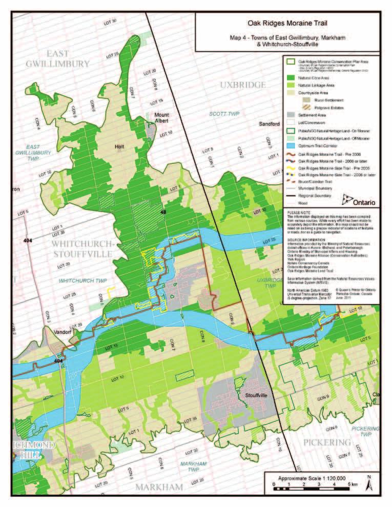
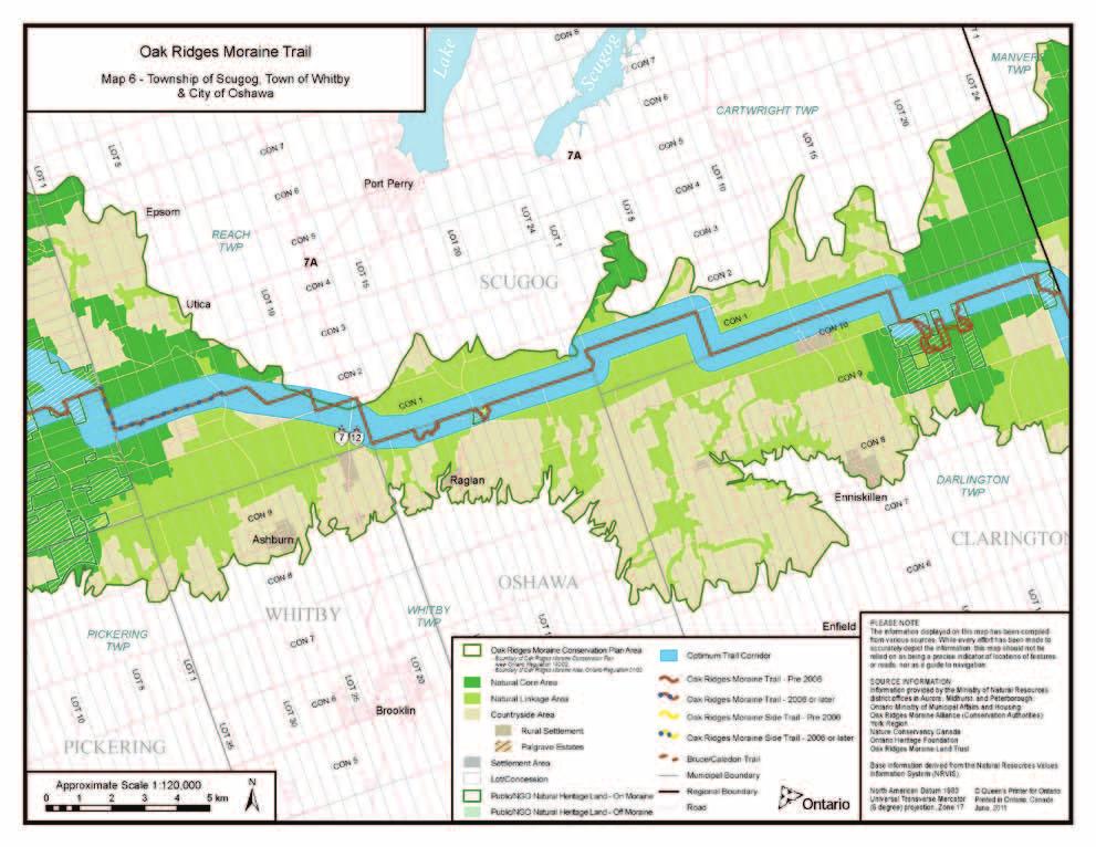
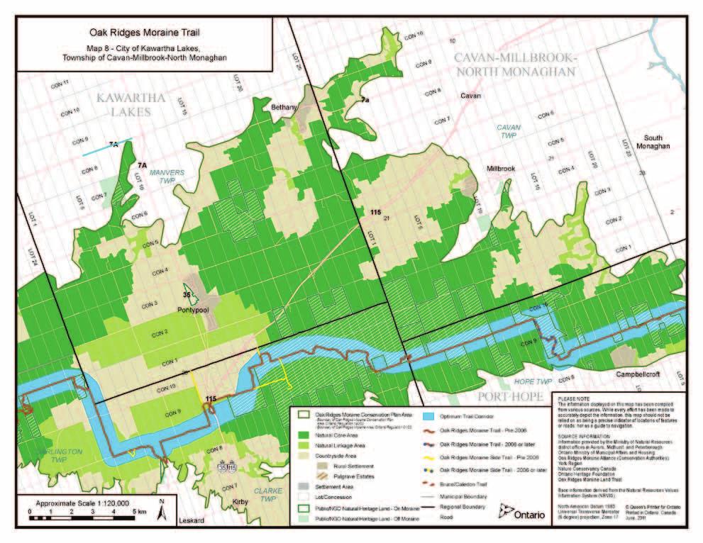
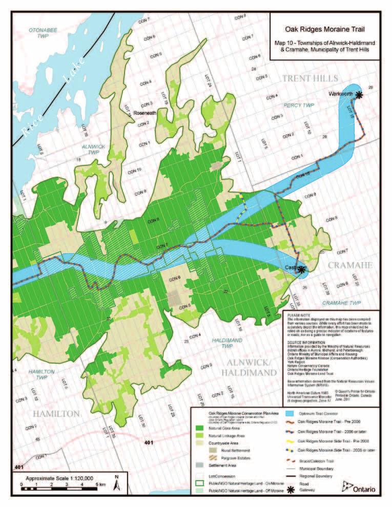
10 3.2 Work Carried Out on Trail Improvements since April 22, 2002 This section provides a summary of accomplishments in relation to the ORMT since 2002 when the ORMCP came into effect. Appendix A contains tabular data that illustrates the kinds of improvements made to the Trail system since 2002; Tables 2 to 5 show detailed tracking of specific benchmarks per section of Trail for the period between April 2006 and October Unfortunately, this level of detail is not available for Table 6 shows a summary of total trail achievements for 2002, 2006 and Photo: Katerina Kondratieva Development of Strategic Plans Since the adoption of the ORMCP, the ORTA has developed and begun to implement its Strategic Plan, which was adopted in 2004 and subsequently revised in The Strategic Plan outlined how the Association will continue the work begun in 1992 to expand, secure, develop, manage and maintain the ORMT along the ORM from the Niagara Escarpment to the Rice Lake Plains. The strategy has defined an Optimum Trail Alignment. As shown in the overview map of the ORMT (See Appendix B), it is a corridor approximately one kilometres wide, extending in an east-west direction across the length of the ORM. This corridor is the preferred location for the Trail based on conformity with the ORMCP. This alignment is used as a general guide for locating and refining a trail that will be approximately one metre in width. Over time, trail improvements and adjustments will seek to follow this alignment. Detailed trail alignments will be based on criteria such as potential for off-road locations, safety, accessibility, opportunities for side trails, protection of ecological integrity, sensitivity to natural and cultural features and opportunities to support other community and recreational activities. The strategy also identifies a number of targets to allow the ORTA to measure its success in achieving its organizational objectives Establishment of Trail Gateways Since 2002, four trail gateways have been developed with one under development. These sites all have signage and parking facilities and will serve as major entry points for the Trail. The gateways are located at Sheppard s Bush in Aurora, Oak Ridges Corridor Park in Richmond Hill, the fairgrounds in Warkworth and the sports playing fields in Castleton. One more is being planned jointly with the Bruce Trail Association in Mono Township where the ORMT connects to the Bruce Trail. The location of these sites is shown on the map in Appendix B. One smaller parking area with signage has been constructed in Northumberland County Forest and another one is planned for the Oak Height Estate Winery in Alnwick/Haldimand. Although these points are not considered formal gateways they are expected to be popular entry points for trail users Establishment of New Trails Since 2002, an additional km of trail have been approved and/or marked, representing a 42% increase in total length of the Trail. This increase includes an additional 75.8 km of trail along a defined main route, which represents the completion of the continuous east-west trail across the entire ORM. This expansion represents an increase of 38%. An additional 27.8 km of side trails, representing an increase of 58%, have been established, forming 11 additional sidetrail routes for a total of 29 side trail loops. Discussions with various stakeholders are currently underway that would increase the total length of side trails and off-road trail options on the main route Improvements to Existing Trails The ORTA has been able to negotiate several alternative routes along the main trail to move 5.5 km on-road portions of the main trail to 6.8 km of off-road trail on properties owned by the Central Lake Ontario Conservation Authority Establishment of New Parking Spaces Since 2002, the number of full parking facilities has increased from 21 to 41. The number of roadside parking areas has increased from 54 to 55 during the same time period. See Table 6 in Appendix A. Note: Full parking facilities are areas where vehicles may be parked in identifiable parking areas off the main travelled roads. Roadside parking areas are locations where cars may be safely parked on the side of the road close to the Trail. 10 Improvements to the Oak Ridges Moraine Trail since the Adoption of the Oak Ridges Moraine Conservation Plan

11 3.2.6 Community Outreach From mid-2008 to present, the Executive Director of the ORTA, in collaboration with the ORMF, launched a major community outreach program aimed at raising the profile of the ORMT, an initiative that included investigating opportunities to expand and improve the Trail. During this period, a large number of organizations and individuals were contacted, including: Six conservation authorities; Twenty municipal bodies; Four trail groups, not including the ORTA; The Nature Conservancy of Canada; Two land trusts; Three community groups; The Government of Canada; and Over 24 private landowners. This outreach effort included over 50 meetings with various organizations and individuals, 24 site inspections, 17 formal presentations of which 14 were to municipal councils and two comprehensive landowner contact programs. Many of the specific increases in trail length and expansion in the number of parking areas discussed elsewhere in this report are directly attributable to these efforts Membership in the Oak Ridges Trail Association The ORTA membership comprises just under 700 members with membership fluctuating between 650 and 700 for several years now. The creation of the Oak Ridges Trail Strategy and the collaboration with the ORMF has helped make the Trail better and longer. However, executive members of the ORTA believe that these activities have also created the impression in many people s minds that the Trail is now looked after by the Province, a circumstance that convinces some that membership in the ORTA is no longer necessary. (Peter Schaefer, personal communication) Production and Sale of the Oak Ridges Trail Guide Since its first issue in 1997, over 7000 copies of the ORTA Guidebook have been sold. The ORTA estimates that it sells about 500 copies each year to both members and non-members. The bookselling industry now considers the Guidebook to be a Canadian bestseller based on its cumulative sales. (Peter Schaefer, personal communication) Identification of Future Opportunities for Trail Improvement Notwithstanding that the ORTA was able to achieve a number of expansions and improvements to the ORMT, the community outreach program discussed in above identified additional opportunities that, if pursued, would generate additional expansion and improvements to the Trail. These include: Improvements to the Yonge Street Corridor Reserve Crossing; The creation of the Oak Ridges Trail Strategy and the collaboration with the ORTA has helped make the Trail better and longer. Establishment of a northern trail corridor in Uxbridge; Establishment of an off-road trail through properties owned by the aggregate industry in York and Durham Regions; Side trail to the City of the Kawartha Lakes; Side trail to the Community of Millbrook; Loop trail in the Northumberland County Forest; Loop trail through Nature Conservancy of Canada property in Alnwick/Haldimand; Loop trail south of the Northumberland County Forest onto properties owned by private land owner; and Trail realignment south of Warkworth to relocate a portion of the Trail off road and onto private land. Photo: Nancy Dickson These options are highly feasible but will require further work, including follow up with stakeholders and a commitment to undertake the necessary work to blaze and maintain these new trails. 11

12 4.0 CONTRIBUTIONS OF THE OAK RIDGES MORAINE FOUNDATION The ORMF has been a significant partner for the ORTA in its mission to develop and secure the Trail. Nine grants totaling $751,826 have enabled the Association to achieve many of its goals and objectives as well as contribute to the requirements under Section 39 of the ORMCP. The ORTA received one of the very first grants from the ORMF, which allowed it to prepare a Strategic Plan for the ORMT. This plan outlined how the Association would expand, secure, develop, manage and maintain the Trail. Given that the ORTA had been a volunteer-run organization, funding was necessary in order to hire staff to implement the activities outlined in the Strategic Plan. In this regard, the ORMF helped to fund positions for both an Executive Director and an Administrative Assistant for the Association. The Foundation also assisted the ORTA with a review of its governance models and by identifying opportunities for increased collaboration with other Moraine organizations. Several grants were also made to assist the ORTA in undertaking trail infrastructure projects and public awareness campaigns. These initiatives included: boardwalks, stiles, parking lots, public service announcements, magazine articles and speaking tours. One of the largest grants made to the ORTA was provided to develop a fundraising activity that would assist the organization in becoming financially self-sustainable. As a result, the Moraine for Life Adventure Relay was created in The Adventure Relay is a 160 km, non-stop team event that involves relay teams traversing the Moraine by canoe, bike and on foot. The event raises funds for the Association and helps to raise awareness of the ORM and its vibrant habitat. Since its inception the event has grown in popularity and now boasts registration of over 450 competitors. In 2008, the Foundation recognized the need for additional effort with respect to trail securement. The Foundation retained a consultant to work with the ORTA in launching a major community outreach program aimed at increasing the profile of the ORMT and securing lands for its further development. 5.0 EFFECTIVENESS OF THE TRAIL PROPONENTS IN ACHIEVING THE TRAIL OBJECTIVES OF THE OAK RIDGES MORAINE CONSERVATION PLAN In assessing the effectiveness of past and current initiatives in the context of the ORMCP, the specific policies of Section 39 of the Plan were assessed against the actual achievements of the ORTA. The results of this assessment are shown in Table 1. Photo: Jeff Hladun 12 Improvements to the Oak Ridges Moraine Trail since the Adoption of the Oak Ridges Moraine Conservation Plan
13 Table 1 An Evaluation of the ORTA s Effectiveness in Meeting the Requirements of Section 39 of the ORMCP Applicable Section of the ORMCP Actual or Inferred Performance Target Level of Achievement by April 22, 2002 Level of Achievement by October 31, 2010 Observation or Comment 39.(1) A recreational trail system shall be established to provide continuous access and travel along the entire Plan Area, accessible to all, including persons with disabilities. A continuous trail from the eastern end of the ORM in the municipality of Trent Hills to the western end of the ORM in the Township of Mono km of main trail from Gores Landing in Hamilton Township in the east to Palgrave in the Town of Caledon in the west km of main trail established from Castleton and Warkworth in the east to Mono Township in the west. The trail is now fully connected from east to west. See section 39. (4) on page 15 for further details on disabled access. 39. (2) The trail system shall, (a) be designed to maintain and, where possible, improve or restore the ecological integrity of the Plan Area. That the trail manager adopt and utilize planning, siting, construction and operational practices that maintain and, where possible, improve ecological integrity. N.A. The ORTA recognizes its obligation with respect to protection of the ecological integrity of the ORM. Its Strategy commits it to adhere to the policies of Section 39(1) of the ORMCP that require activities on the ORM be limited to low-intensity recreational uses and that the trails be designed to have minimal impact. Since the existing and proposed new trails require little disturbance of terrain or vegetation and will avoid highly sensitive areas to the fullest extent possible, there should be minimal impact on ecological integrity. In addition, when a new trail is being considered through an area identified as environmentally sensitive, ORTA consults with the appropriate conservation group for planning alignment, construction and operational advice. The ORTA will continue to adhere to this policy as one of its main operating principles, a commitment that is reflected in its current Strategic Plan. 13
14 Applicable Section of the ORMCP Actual or Inferred Performance Target Level of Achievement by April 22, 2002 Level of Achievement by October 31, 2010 Observation or Comment 39. (2) The trail system shall, b) be located in the Natural Core Areas and Natural Linkage Areas as much as possible. 100% of the main trail should be located within the Natural Core and Linkage Areas of the ORMCP. The ORTA created an Optimum Trail Corridor that identified the ideal alignment for the Trail, which by and large passed through either Natural Core or Natural Linkage. All new main trails created since 2002 have occurred predominately (i.e. over 80%) within the Optimum Trail Corridor and/or in areas designated Natural Core and Natural Linkage. 39. (2) The trail system shall, (c) be located away from unopened road allowances as much as possible. No trails should be located on road allowances that are being used or planned for future car and truck transport. N.A. The ORTA recognizes the need to pursue opportunities to relocate the existing Trail away from municipal roads as well as unopened road allowances planned for upgrade to full municipal road standards. The ORTA and the ORMF have interpreted this policy to mean the avoidance of trails on unopened road allowances where they will become less desirable for long-term use if they are upgraded to full municipal road standards. There are many unopened roads where conversion to full municipal road standards is unlikely and these make ideal locations for the ORMT. 39. (3) Despite anything else in this Plan, the following uses, buildings and structures are permitted on the trail system: 1. Non-motorized trail uses. All the ORTA trails are located on trails where motorized trail use is not permitted. The ORMT is designed for nonmotorized trail uses and, to the extent possible, seeks trail locations where motorized use is not permitted. The ORMT is designed for nonmotorized use. Although the ORMT is designed for nonmotorized use, the ORTA and the ORMF have no control over the uses permitted on the Trail. That right is retained by the landowner. 14 Improvements to the Oak Ridges Moraine Trail since the Adoption of the Oak Ridges Moraine Conservation Plan
15 Applicable Section of the ORMCP Actual or Inferred Performance Target Level of Achievement by April 22, 2002 Level of Achievement by October 31, 2010 Observation or Comment 39. (3) Despite anything else in this Plan, the following uses, buildings and structures are permitted on the trail system: 2. Parking, signage, washrooms and interpretive facilities to support access to the trail system. The ORMT provides for parking, signage, washroom and interpretive facilities to support access to the trail system. The ORMT allows for all the uses identified in this subsection of the ORMCP. The ORMT allows for all the uses identified in this subsection of the ORMCP. The ORTA does not envision the establishment of uses outside the range of uses set out in the ORMCP. Although the ORMT is designed to accommodate these uses, the ORTA and the ORMF have no control over the uses ultimately permitted on the Trail. That right is retained by the landowner. 39. (3) Despite anything else in this Plan, the following uses, buildings and structures are permitted on the trail system: 3. Fencing to define and protect the trails. The ORMT can permit fencing along the Trail to define and protect the Trail. The ORTA has provided fencing and signage in the past to protect the Trail and to demarcate boundaries between the Trail and private property. The ORTA will continue to provide fencing and signage where appropriate to protect the Trail and to demarcate boundaries between the Trail and private property where deemed necessary. 15
16 Applicable Section of the ORMCP Actual or Inferred Performance Target Level of Achievement by April 22, 2002 Level of Achievement by October 31, 2010 Observation or Comment 39. (3) Despite anything else in this Plan, the following uses, buildings and structures are permitted on the trail system: 4. Works to improve access to the trail system and remove barriers to its use, for the benefit of all including persons with disabilities. The ORMT must make provision for the trail system that is accessible to all, including disabled persons. N.A. The ORTA Strategy is committed to making the ORMT accessible for all Ontarians, including those with disabilities. In the design and construction of new trail sections and the reconstruction of existing sections, the ORTA uses the guide developed by the Trails for All Ontarians Collaborative (2006). Within the parameters of environmental protection, the Strategic Plan commits the ORTA to pursue a trail that can be enjoyed by Ontarians of all abilities. On sections of the Trail, the Universal Trail Assessment Process will be used to provide trail users with objective information about on-trail conditions and to identify sections of the Trail where accessibility could be increased with reasonable modifications or improvements. To date over 12 km of the existing Trail have been assessed using the Universal Trail Assessment Process. 16 Improvements to the Oak Ridges Moraine Trail since the Adoption of the Oak Ridges Moraine Conservation Plan
17 Applicable Section of the ORMCP Actual or Inferred Performance Target Level of Achievement by April 22, 2002 Level of Achievement by October 31, 2010 Observation or Comment 39. (3) Despite anything else in this Plan, the following uses, buildings and structures are permitted on the trail system: 5. Works to protect ecologically sensitive portions of the trail system. 6. Conservation and erosion control to protect or restore key natural heritage features and hydrologically sensitive features and the related ecological functions along the trail system. The ORTA can permit works on the Trail that provide erosion control when protecting natural heritage and ecological and hydrological features. N.A. Under its strategy, the ORTA commits to ensuring that the intent of the ORMCP is met by carrying out trail design, construction and maintenance in a manner that considers environmental impacts. 39. (4) Paragraph 1 of subsection (3) does not prohibit the use of motorized wheelchairs by persons who need them for mobility. The ORMT can provide for access by motorized wheelchairs. N.A. ORTA will provide for motorized wheelchair access to the Trail where appropriate. Under its Universal Accessible Trail Program, the ORTA has identified 1.2 km of trail that are accessible for motorized wheelchair use. This inventory program is in its early stages of development and will no doubt identify and/ or develop additional trail sections that are suitable for such forms of access. 17
18 6.0 FUTURE CHALLENGES FOR THE MAINTENANCE AND IMPROVEMENT OF THE OAK RIDGES MORAINE TRAIL The single biggest challenge to the ORTA is its ability to find the resources (financial and human) to maintain current trail assets and to pursue high potential opportunities. Since 2002, the ORTA has been able to draw on financial and support services available from the ORMF. Unfortunately, there is no guarantee that funding from this source will continue. In addition, the ORTA has cited volunteer burn-out and dropping membership as circumstances that will challenge its ability to maintain even its current level of activity. Both the ORTA and the ORMF need to do a focused evaluation of the Association s probable ability to support the ORMT initiative in the future, including a consideration of whether or not future efforts should include pursuing the high profile opportunities identified in Section of this report. 7.0 OBSERVATIONS Observation #1: The ORTA, through its strategic plans and its trail development and management practices, has demonstrated how it has adhered to the planning, design and operational policies of the ORMCP as outlined in Section 39. Observation #2: Since 2006, the ORTA, with direct financial and planning support from the ORMF, has been able to achieve the ORMCP s objective of establishing a continuous east-west trail across the entire ORM. Observation #3: Since 2006, the ORTA, with direct financial and staffing support from the ORMF, has been able to identify a number of opportunities to improve the ORMT by moving on-road portions of the main trail to off-road alternatives, increasing the number of side trails and increasing the number of parking and roadside parking opportunities along the Trail. Observation #4: Since 2008, the ORTA, with financial and staffing support from the ORMF, has identified a number of high potential opportunities for further improving the ORMT. These opportunities will require additional landowner contact and trail marking and blazing to reach fruition. The Association will not likely be able to pursue these opportunities without additional funding. Observation #5: The ORTA can be justly proud of its accomplishments since As a volunteer group it has created and managed one of the largest trail systems in Ontario. However, the Association has expressed concerns that the expanded trail system will tax the capacity of its volunteer resources to maintain even the current trail length. The Association is presently in a state of reassessing its vision and commitments in light of current and potential future funding. Observation #6: The ORTA recognizes that the public s perception of its role in Trail stewardship since 2004 must be refreshed and constantly re-communicated as there is a general feeling that since collaborating with the ORMF on meeting ORMCP objectives membership in the ORTA is not needed. Observation #7 Completion of future opportunities for trail improvements will depend in large part on the ability of the ORTA, the ORMF and its other partners to identify resources (financial and staff) needed to follow up on high potential opportunities. This may require alternative governance models and more targeted communications to address more effectively these opportunities. 8.0 RECOMMENDATIONS Recommendation #1: The Foundation should seek funds from the Province to continue to support activities that maintain and improve the Oak Ridges Moraine Trail in partnership with the Oak Ridges Trail Association and other stakeholders Recommendation #2: The Foundation and the Oak Ridges Trail Association ORTA should explore alternative governance models to more effectively seek the involvement of other stakeholders in the maintenance and improvement of the Oak Ridges Moraine Trail including: Seeking additional sources of funding; and Seeking greater support and enhanced partnerships with other stakeholders having an interest in trail development such as conservation authorities, municipalities and community forest groups. 18 Improvements to the Oak Ridges Moraine Trail since the Adoption of the Oak Ridges Moraine Conservation Plan

19 REFERENCES Oak Ridges Trail Association 2003 Guide for Trail Maintenance, Revised June 5, 2003 Oak Ridges Moraine Trail Association 2004 Oak Ridges Trail Guidebook Oak Ridges Moraine Trail Association 2004 A Strategic Plan for The Oak Ridges Trail, February 2, 2004 Oak Ridges Moraine Trail Association 2006 Oak Ridges Trail Guidebook, Revised April 2006 Oak Ridges Trail Association 2009 Strategic Directions , A Strategic Plan for the Oak Ridges Trail, approved by the Oak Ridges Trail Association Board of Directors on January 31, 2009 Oak Ridges Trail Association 2009 Oak Ridges Trail Guidebook, Revised December 2009 Oak Ridges Trail Association 2010 A Guide to Universally Accessible Trail on the Oak Ridges Moraine Trail Province of Ontario 2002 Oak Ridges Moraine Conservation Plan. Adopted as a Regulation to the Oak Ridges Moraine Conservation Act on April 22, Schaefer, Peter (October 29, 2010), President Oak Ridges Trail Association Personal Communication Trails for All Collaborative 2006 Ontario s Best Trails: Guidelines and Best Practices for the Design, Construction and Maintenance of Sustainable Trails for All Ontarians Photo: Elaine Uskoski 19
20 Appendix A Tables 2 6 Table 2 Summary of the Status of the Main Trail in April 2006 Chapter/ Area of the ORM Main Trail Length in Km Trail Length on Public Land in Km Trail Length on Private Land in Km Trail Length on Public Road in Km Trail Length on Unopened Road Allowance in Km Humber Headwaters Caledon King Aurora Richmond Hill Whitchurch- Stouffville Uxbridge Scugog Clarington Hope/Hamilton Alnwick/ Haldimand Cramahe Trent Hills Total (100%) (25.8%) (9.2%) (43.7%) (21.2%) 20 Improvements to the Oak Ridges Moraine Trail since the Adoption of the Oak Ridges Moraine Conservation Plan
21 Table 3 Summary of the Status of the Main Trail in October 2010 Chapter/ Area of the ORM Main Trail Length in Km Trail Length on Public Land in Km Trail Length on Private Land in Km Trail Length on Public Road in Km Trail Length on Unopened Road Allowance in Km Humber Headwaters Caledon King Aurora Richmond Hill Whitchurch- Stouffville Uxbridge Scugog Clarington Hope/Hamilton Alnwick/ Haldimand Cramahe Trent Hills Total (100%) (31%) (7.3%) (41.6%) (20%) 21
22 Table 4 Summary of Ancillary Services along the Main Trail in April 2006 Chapter/ Area of the ORM Number of Side Trails Side Trail Length in Km Number of Parking Lots* Number of Roadside Parking Opportunities* Number of Gateway Sites Humber Headwaters Caledon King Aurora Richmond Hill Whitchurch- Stouffville Uxbridge Scugog Clarington Hope/Hamilton Alnwick/ Haldimand Cramahe Trent Hills Total * Parking lot facilities are areas where vehicles may be parked in identifiable parking areas off the main travelled roads. Roadside parking areas are locations where cars may be safely parked on the side of the road close to the Trail. 22 Improvements to the Oak Ridges Moraine Trail since the Adoption of the Oak Ridges Moraine Conservation Plan
23 Table 5 Summary of Ancillary Services along the Main Trail in October 2010 Chapter/ Area of the ORM Number of Side Trails Side Trail Length in Km Number of Parking Lots* Number of Roadside Parking Opportunities* Number of Gateway Sites Humber Headwaters Caledon King Aurora Richmond Hill Whitchurch- Stouffville Uxbridge Scugog Clarington Hope/Hamilton Alnwick/ Haldimand Cramahe Trent Hills Total * Parking lot facilities are areas where vehicles may be parked in identifiable parking areas off the main travelled roads. Roadside parking areas are locations where cars may be safely parked on the side of the road close to the Trail. 23
24 Table 6 Summary of Trail Changes 2002 to 2010 April 2002 April 2006 October 2010 Difference 2002 to 2010 % Change Total Main Trail Length in Km Side Trail Length in Km % % Number of Side Trails % Total Trail Length in Km % Number of Parking Sites * % Number of Roadside Parking Opportunities* 54** % Number of Gateway Sites Not Applicable but +3 since 2006 Not applicable but 300% since 2006 * Parking lot facilities are areas where vehicles may be parked in identifiable parking areas off the main travelled roads. Roadside parking areas are locations where cars may be safely parked on the side of the road close to the Trail. ** This figure is somewhat misleading insofar as it indicates a reduction in subsequent years. However, the reduction was part of a rationalization in situations where several small, inadequate sites were replaced by ones of better overall quality in the same general areas. 24 Improvements to the Oak Ridges Moraine Trail since the Adoption of the Oak Ridges Moraine Conservation Plan

25 Appendix B Trail Maps 25
26
27
28

29 29 Improvements to the Oak Ridges Moraine Trail since the Adoption of the Oak Ridges Moraine Conservation Plan
30 30

31 31 Improvements to the Oak Ridges Moraine Trail since the Adoption of the Oak Ridges Moraine Conservation Plan
32 32

33 33 Improvements to the Oak Ridges Moraine Trail since the Adoption of the Oak Ridges Moraine Conservation Plan
34 34

35 35 Improvements to the Oak Ridges Moraine Trail since the Adoption of the Oak Ridges Moraine Conservation Plan
36 36

37 37 Improvements to the Oak Ridges Moraine Trail since the Adoption of the Oak Ridges Moraine Conservation Plan
38 38
39 39 Improvements to the Oak Ridges Moraine Trail since the Adoption of the Oak Ridges Moraine Conservation Plan
40 40
41 41 Improvements to the Oak Ridges Moraine Trail since the Adoption of the Oak Ridges Moraine Conservation Plan
42 42
43 Oak Ridges Moraine Foundation The Gate House Dufferin Street North King City, Ontario L7B 1B3 Phone:
SUSTAINING OUR ENVIRONMENT, PLANNING FOR OUR FUTURE
 SUSTAINING OUR ENVIRONMENT, PLANNING FOR OUR FUTURE Key Recommendations to Inform the 2015 Provincial Review of the Oak Ridges Moraine Conservation Plan APRIL 2015 KEY RECOMMENDATIONS TO INFORM THE 2015
Proposed Official Plan Amendment 41 to the Region of York Official Plan
 COMMITTEE OF THE WHOLE NOVEMBER 18, 2002 REGION OF YORK OFFICIAL PLAN AMENDMENT 41 THE OAK RIDGES MORAINE CONSERVATION PLAN Recommendation The Commissioner of Planning recommends: 1. That the City of Vaughan
October 31, OAK RIDGES MORAINE FOUNDATION 120 BAYVIEW PARKWAY, NEWMARKET, ON L3Y 3W
 October 31, 2016 Land Use Planning Review Ministry of Municipal Affairs and Housing Ontario Growth Secretariat 777 Bay Street, Suite 425 (4th Floor) Toronto, ON M5G 2E5 RE: Oak Ridges Moraine Foundation
Land, Water and Community: Preparing for a Successful 2015 Review
 Land, Water and Community: Preparing for a Successful 2015 Review Outline ORM Partnership for 2015 Preparing for 2015: Three Plans versus Four Plans Our Areas of Focus Governance & the 2015 Process Our
OAK RIDGES MORAINE FOUNDATION
 June 2009 OAK RIDGES MORAINE FOUNDATION The Oak Ridges Moraine Foundation was created in 2002 to help preserve, protect and restore the environmental integrity of the Oak Ridges Moraine, a prominent geological
Establishing a National Urban Park in the Rouge Valley
 STAFF REPORT ACTION REQUIRED Establishing a National Urban Park in the Rouge Valley Date: March 29, 2012 To: From: Wards: Reference Number: Executive Committee Deputy City Manager, Cluster B All p:\2012\cluster
Preferred Recreation Recommendations Stemilt-Squilchuck Recreation Plan March 2018
 Preferred Recreation Recommendations Stemilt-Squilchuck Recreation Plan March 2018 Below are the recommended recreation ideas and strategies that package together the various recreation concepts compiled
Committee. Presentation Outline
 CW-33-15 11/9/2015 Community and Corporate Services Committee November 10, 2015 1 Presentation Outline Background Vision and Objectives Study Process and Timeline Public and Stakeholder Engagement Organization
Continental Divide National Scenic Trail Legislative History and Planning Guidance
 Continental Divide National Scenic Trail Legislative History and Planning Guidance Legislation, Policy, and Direction Regarding National Scenic Trails The National Trails System Act, P.L. 90-543, was passed
Request for a Review of the Oak Ridges Moraine Conservation Plan and Related Initiatives
 Request for a Review of the Oak Ridges Moraine Conservation Plan and Related Initiatives Purpose: The Applicant requests a review of existing policies, legislation, regulation and/or technical guidance
Ministry of Parks, Culture and Sport. Plan for saskatchewan.ca
 Ministry of Parks, Culture and Sport Plan for 2018-19 saskatchewan.ca Table of Contents Statement from the Minister... 1 Response to Government Direction... 2 Operational Plan... 3 Highlights... 7 Financial
BACKCOUNTRY TRAIL FLOOD REHABILITATION PROGRAM
 BACKCOUNTRY TRAIL FLOOD REHABILITATION PROGRAM Backcountry Trail Flood Rehabilitation A June 2013 Flood Recovery Program Summary In June 2013, parts of Southern Alberta were devastated from significant
AMENDMENT NO. 03 TO THE OFFICIAL PLAN FOR THE TOWNSHIP OF ADJALA-TOSORONTIO OAK RIDGES MORAINE CONSERVATION PLAN
 AMENDMENT NO. 03 TO THE OFFICIAL PLAN FOR THE TOWNSHIP OF ADJALA-TOSORONTIO OAK RIDGES MORAINE CONSERVATION PLAN Adopted by Council July 19 th, 2004 Approved with modifications by the Province of Ontario
Bayview Escarpment. Interim Management Statement
 Bayview Escarpment Interim Management Statement Bayview Escarpment Provincial Nature Reserve Interim Management Statement January 15, 1995 REGIONAL DIRECTOR'S APPROVAL STATEMENT This Interim Management
Ontario Municipal Board Commission des affaires municipales de l Ontario
 Ontario Municipal Board Commission des affaires municipales de l Ontario ISSUE DATE: February 27, 2015 CASE NO(S).: PL140972 PROCEEDING COMMENCED UNDER subsection 34(19) of the Planning Act, R.S.O. 1990,
Parkland County Municipal Development Plan Amendment Acheson Industrial Area Structure Plan
 Parkland County Municipal Development Plan Amendment Acheson Industrial Area Structure Plan New Plan Acheson Industrial Area Structure Plan Amendment Parkland County Municipal Development Plan Board Reference
Amendment 41 to the Official Plan for the Regional Municipality of York
 Attachment 3 Council Report Attachment Amendment 41 to the Official Plan for the Regional Municipality of York As approved by the Minister of Municipal Affairs and Housing October 21, 2004 Deferred policies
Boyne Valley Provincial Park. Interim Management Statement
 Boyne Valley Provincial Park Interim Management Statement January 20, 1995 REGIONAL DIRECTOR'S APPROVAL STATEMENT This Interim Management Statement will provide interim direction for the management of
Applicability of the Oak Ridges Moraine Conservation Plan and the Greenbelt Plan to the Preparation and Implementation of the Northumberland County
 Applicability of the Oak Ridges Moraine Conservation Plan and the Greenbelt Plan to the Preparation and Implementation of the Northumberland County Forest Master Plan October 25, 2007 V3 NOTE: This report
PSP 75 Lancefield Road. Northern Jacksons Creek Crossing Supplementary Information
 PSP 75 Lancefield Road Northern Jacksons Creek Crossing Supplementary Information September 2017 The northern crossing of Jacksons Creek proposed within the Lancefield Road PSP is a key part of the ultimate
Economic Development and Tourism
 SECTION 4 SECTION 4 Economic Development and Tourism 4. Economic Development and Tourism Tourism plays a very important role in Niagara s economy, providing employment and generating business for support
2 YORK REGION TRANSIT MOBILITY PLUS 2004 SYSTEM PERFORMANCE REVIEW
 2 YORK REGION TRANSIT MOBILITY PLUS 2004 SYSTEM PERFORMANCE REVIEW The Joint Transit Committee and Rapid Transit Public/Private Partnership Steering Committee recommends the adoption of the recommendation
50th Anniversary Milestones Project
 N a v i g a t i n g t h e Le g i s l a t i ve L a n d s ca p e The physical landscape of Southern Ontario is characterized by stunning, diverse and sensitive natural features such as the Niagara Escarpment
CITY CLERK. Oak Ridges Moraine Update. The Planning and Transportation Committee recommends that:
 CITY CLERK Clause embodied in Report No. 8 of the, as adopted by the Council of the City of Toronto at its meeting held on July 24, 25 and 26, 2001. 5 Oak Ridges Moraine Update (City Council on July 24,
Land Management Summary
 photo credit: ANGAIR Anglesea Heath Land Management Summary The Anglesea Heath (6,501 ha) was incorporated into the Great Otway National Park in January 2018. This provides an opportunity to consider the
Ontario Municipal Board Commission des affaires municipales de l Ontario
 Commission des affaires municipales de l Ontario ISSUE DATE: July 25, 2014 CASE NO: PL130788 PROCEEDING COMMENCED UNDER subsection 17(36) of the Planning Act, R.S.O. 1990, c. P.13, as amended Subject:
A GUIDE TO MANITOBA PROTECTED AREAS & LANDS PROTECTION
 A GUIDE TO MANITOBA PROTECTED AREAS & LANDS PROTECTION Manitoba Wildands December 2008 Discussions about the establishment of protected lands need to be clear about the definition of protection. We will
April 10, Mark Stiles San Juan Public Lands Center Manager 15 Burnett Court Durango, CO Dear Mark,
 Mark Stiles San Juan Public Lands Center Manager 15 Burnett Court Durango, CO 81301 Dear Mark, We are pleased to offer the following comments on the draft San Juan Public Lands Center management plans
(1) GENERAL POLICIES (2) EXISTING USES
 GENERAL POLICIES (2) EXISTING USES") (1) GENERAL POLICIES (d) (e) The policies of Section 20 shall apply to all lands located within the area shown on Schedule A - Land Use and Roads Plan as Oak Ridges Moraine. Schedule E-1 - Oak Ridges Moraine
(1) GENERAL POLICIES (d) (e) The policies of Section 20 shall apply to all lands located within the area shown on Schedule A - Land Use and Roads Plan as Oak Ridges Moraine. Schedule E-1 - Oak Ridges Moraine
EX28.6 REPORT FOR ACTION. Advancing Fare Integration SUMMARY. Date: October 16, 2017 To: Executive Committee From: City Manager Wards: All
 EX28.6 REPORT FOR ACTION Advancing Fare Integration Date: October 16, 2017 To: Executive Committee From: City Manager Wards: All SUMMARY In July 2016, City Council considered a current state assessment
Ontario Municipal Board Commission des affaires municipales de l Ontario
 ISSUE DATE: January 27, 2014 PL130137 Ontario Municipal Board Commission des affaires municipales de l Ontario Peter Eliopoulos has appealed to the Ontario Municipal Board under subsection 22(7) of the
Marchand Provincial Park. Management Plan
 Marchand Provincial Park Management Plan 2 Marchand Provincial Park Table of Contents 1. Introduction... 3 2. Park History... 3 3. Park Attributes... 4 3.1 Natural... 4 3.2 Recreational... 4 3.3 Additional
Belfountain Complex - Stakeholder Advisory Committee Meeting Belfountain Conservation Area Property Tour Date: Time: Meeting Purpose
 Belfountain Complex - Stakeholder Advisory Committee Meeting Belfountain Conservation Area Property Tour Date: Thursday, October 9, 2014 Time: 6:00pm 7:30pm Meeting Purpose: A tour of Belfountain Conservation
Section II. Planning & Public Process Planning for the Baker/Carver Regional Trail began in 2010 as a City of Minnetrista initiative.
 Section II Planning & Public Process Planning for the began in 2010 as a City of initiative. city staff began discussions with the Park District on the possibility of a north/south regional trail connection
Policy PL Date Issued February 10, 2014
 Subject RENEWABLE ENERGY ON CROWN LAND Compiled by Renewable Energy Program, Biodiversity Branch Replaces Policy Directives Waterpower Site Release Crown Land Onshore Windpower Development - Crown Land
3.0 LEARNING FROM CHATHAM-KENT S CITIZENS
 3.0 LEARNING FROM CHATHAM-KENT S CITIZENS An important aspect in developing the Chatham-Kent Trails Master Plan was to obtain input from stakeholders and the general public. Throughout the course of the
METROPOLITAN COUNCIL 390 North Robert Street, St. Paul, MN Phone (651) TDD (651)
 TDD (651)") DATE: March 27, 2012 METROPOLITAN COUNCIL 390 North Robert Street, St. Paul, MN 55101 Phone (651) 602-1000 TDD (651) 291-0904 TO: Metropolitan Parks and Open Space Commission FROM: Arne Stefferud, Planning
DATE: March 27, 2012 METROPOLITAN COUNCIL 390 North Robert Street, St. Paul, MN 55101 Phone (651) 602-1000 TDD (651) 291-0904 TO: Metropolitan Parks and Open Space Commission FROM: Arne Stefferud, Planning
The Corporation of the City of Kawartha Lakes Council Report
 The Corporation of the City of Kawartha Lakes Council Report Report Number ENG2017-008 Date: September 12, 2017 Time: 2:00 p.m. Place: Council Chambers Ward Community Identifier: All Subject: Author Name
Port Bruce. Interim Management Statement
 Port Bruce Interim Management Statement Port Bruce Interim Management Statement August 3, 1999 This Port Bruce Provincial Park Interim Management Statement provides direction for the custodial management
JOSLIN FIELD, MAGIC VALLEY REGIONAL AIRPORT DECEMBER 2012
 1. Introduction The Federal Aviation Administration (FAA) recommends that airport master plans be updated every 5 years or as necessary to keep them current. The Master Plan for Joslin Field, Magic Valley
PROPOSED PARK ALTERNATIVES
 8 Chimne y Rock State Park M a ster Pl an 2011 PROPOSED PARK ALTERNATIVES Introduction Three different park development concepts were prepared and presented to the citizens of North Carolina through a
Planning & Building Department
 Page 1 of Report Planning & Building Department To: Subject: Community Development Committee Protecting Escarpment Rural Land (PERL) Proposed Niagara Escarpment Plan Amendment Niagara Escarpment Commission
Submission to NSW Koala Strategy Consultation Process. March 2017
 Submission to NSW Koala Strategy Consultation Process March 2017 Table of contents Opening 3 Response 3 Whole-of-government NSW koala strategy 3 State Environment Planning Policy (SEPP) 44 3 The draft
PROUDLY BRINGING YOU CANADA AT ITS BEST. Management Planning Program NEWSLETTER #1 OCTOBER, 2000
 PROUDLY BRINGING YOU CANADA AT ITS BEST VUNTUT NATIONAL PARK Management Planning Program NEWSLETTER #1 OCTOBER, 2000 INTRODUCTION This newsletter launches the development of the first management plan for
Geoscape Toronto The Oak Ridges Moraine Activity 2 - Page 1 of 10 Information Bulletin
 About 13,000 years ago as the Laurentide Ice Sheet melted, glacial meltwater accumulated between the ice sheet and the Niagara Escarpment. This formed a lake basin into which gravel and sand were deposited.
Terms of Reference: Introduction
 Terms of Reference: Assessment of airport-airline engagement on the appropriate scope, design and cost of new runway capacity; and Support in analysing technical responses to the Government s draft NPS
RUSHMORE CONNECTOR TRAIL PROPOSAL
 PURPOSE AND NEED Background The U.S. Forest Service, Black Hills National Forest (Forest Service) has received a special use permit application from the State of South Dakota Department of Game, Fish and
6 Agricultural. and Rural Areas. Chapter. In this chapter:
 Chapter 6 Agricultural and Rural Areas In this chapter: 6.1 The Greenbelt Plan 6.2 The Oak Ridges Moraine Conservation Plan 6.3 Agricultural and Holland Marsh Specialty Crop Areas 6.4 Rural Area 6.5 Mineral
MANAGEMENT DIRECTION STATEMENT June, 1999
 Thompson River District MANAGEMENT DIRECTION STATEMENT June, 1999 for Roche Lake Provincial Park Ministry of Environment Lands and Parks BC Parks Division Table of Contents I. Introduction A. Setting
August 29, Concerned Citizens of King Township. Oak Ridges Moraine Conservation Plan/Greenbelt Plan 2015 Policy Review
 August 29, 2014 Concerned Citizens of King Township Oak Ridges Moraine Conservation Plan/Greenbelt Plan 2015 Policy Review Table of Contents Page 1.0 Executive Summary 3 2.0 Background 4 3.0 Implementation
CITY OF VAUGHAN EXTRACT FROM COUNCIL MEETING MINUTES OF OCTOBER 30, 2012
 CITY OF VAUGHAN EXTRACT FROM COUNCIL MEETING MINUTES OF OCTOBER 30, 2012 Item 36, Report No. 39, of the Committee of the Whole, which was adopted without amendment by the Council of the City of Vaughan
PUBLIC ACCOUNTABILITY PRINCIPLES FOR CANADIAN AIRPORT AUTHORITIES
 PUBLIC ACCOUNTABILITY PRINCIPLES FOR CANADIAN AIRPORT AUTHORITIES The Canadian Airport Authority ( CAA ) shall be incorporated in a manner consistent with the following principles: 1. Not-for-profit Corporation
January 14, Orange County Transportation Authority Attn: M2 NCCP/HCP 550 South Main Street P.O. Box Orange, CA
 Equestrian Trails, Inc. Corral 357 P.O. Box 1026 Trabuco Canyon, CA 92678 http://saddlebackcanyonriders.com/ President: James Iacono... 714-612-1789 January 14, 2016 Orange County Transportation Authority
Cavan Monaghan Trail Master Plan. Prepared by Otonabee Conservation for The Township of Cavan Monaghan
 Cavan Monaghan Trail Master Plan Prepared by Otonabee Conservation for The Township of Cavan Monaghan June 2010 Acknowledgements Thank you to the following individuals and organizations for their assistance
Brampton, Ontario REQ. no.: PLANNING, DESIGN & DEVELOPMENT COMMITTEE
 ftorontoand REGION rv~ Conservation for The Living City May 22,2009 2I22V,5L CFN 42397 CLERK S DEPT. Mr. Peter Fay City Clerk, City of Brampton MAY 2 7 2008 2 Wellington Street West Brampton, Ontario REQ.
OFFICIAL PLAN AMENDMENT 604 TO THE VAUGHAN PLANNING AREA
 OFFICIAL PLAN AMENDMENT 604 TO THE VAUGHAN PLANNING AREA AMENDING OFFICIAL PLAN AMENDMENTS 332, 350 AND 600 TO BRING THEM INTO CONFORMITY WITH THE OAK RIDGES MORAINE CONSERVATION PLAN, ONTARIO REGULATION
Draft Executive Summary
 Draft Executive Summary The Juneau Tourism Plan development process was undertaken by Egret Communications and ARA Consulting in April 2001, under contract with the City and Borough of Juneau, Alaska.
INFORMATION ONLY. Subject: Metrolinx Presentation Date: June 22, 2015
 INFORMATION ONLY Subject: Metrolinx Presentation Date: June 22, 2015 At its meeting on June 22, 2015, the TTC Board will receive a presentation on Metrolinx from Robert Prichard, Metrolinx Board Chair
Town of Caledon 2013/14 update. October 8 th, 2013
 Town of Caledon 2013/14 update October 8 th, 2013 Mission & approach The Hills of Headwaters Tourism Association, working on behalf of and in conjunction with our partners and regional tourism operators
PERFORMANCE INDICATORS
 PERFORMANCE INDICATORS for the greenbelt plan Part 1, 2015 Ontario.ca/mah PERFORMANCE INDICATORS for the greenbelt plan Part 1, 2015 TABLE OF CONTENTS Page Welcome to Greenbelt Plan Performance Indicators
4 VIVA PHASE 2 YONGE STREET - Y2, AND HIGHWAY 7 - H3 CORRIDORS PRELIMINARY ENGINEERING UPDATE
 4 VIVA PHASE 2 YONGE STREET - Y2, AND HIGHWAY 7 - H3 CORRIDORS PRELIMINARY ENGINEERING UPDATE The Rapid Transit Public/Private Partnership Steering Committee recommends the following: 1. The presentation
As outlined in the Tatshenshini-Alsek Park Management Agreement, park management will:
 Management Strategy General Strategy The priority management focus for the park is to ensure that its internationally significant natural, cultural heritage and recreational values are protected and that
County of Elgin Tourism Signage Policy Addendum A
 1.0 INTRODUCTION County of Elgin Tourism Signage Policy Addendum A 1.1 PURPOSE OF ELGIN TOURISM SIGNAGE POLICY To define the eligibility, use, design and authority for tourism oriented directional signage
RE: Access Fund Comments on Yosemite National Park Wilderness Stewardship Plan, Preliminary Ideas and Concepts
 September 30, 2016 Superintendent Yosemite National Park Attn: Wilderness Stewardship Plan P.O. Box 577 Yosemite, CA 95389 RE: Access Fund Comments on Yosemite National Park Wilderness Stewardship Plan,
Proposal to Redevelop Lower Kananaskis River-Barrier Lake. Bow Valley Provincial Park
 Frequently Asked Questions Proposal to Redevelop Lower Kananaskis River-Barrier Lake Bow Valley Provincial Park Frequently Asked Questions What has been decided? What are the details of the plan? What
This page has been intentionally left blank.
 This page has been intentionally left blank. Chapter 2 2-2 2. Growing the Economy In many ways, the Niagara Region is a community of communities and this is becoming increasingly so. It is made up of towns
Watchorn Provincial Park. Management Plan
 Watchorn Provincial Park Management Plan 2 Watchorn Provincial Park Table of Contents 1. Introduction... 3 2. Park History... 3 3. Park Attributes... 3 3.1 Natural... 4 3.2 Recreational... 4 3.3 Additional
Accountability Report
 2017-2018 Accountability Report Tourism Nova Scotia Contents Accountability Statement... 3 Message from the Chair & CEO... 4 Financial Results... 6 Measuring Our Performance... 7 Accountability Statement
National Wilderness Steering Committee
 National Wilderness Steering Committee Guidance White Paper Number 1 Issue: Cultural Resources and Wilderness Date: November 30, 2002 Introduction to the Issue Two of the purposes of the National Wilderness
Item No Halifax Regional Council April 10, 2018
 P.O. Box 1749 Halifax, Nova Scotia B3J 3A5 Canada Item No. 14.3.2 Halifax Regional Council April 10, 2018 TO: SUBMITTED BY: Mayor Savage and Members of Halifax Regional Council Original Signed Councillor
Chapter 1: Introduction Draft
 Chapter 1: Draft TABLE OF CONTENTS 1... 4 1.6.1 Stakeholder Engagement Plan... 10 Chapter 1 Page 2 TABLE OF EXHIBITS Exhibit 1.1-1 ABIA Annual Growth Since 1993... 5 Exhibit 1.4-1: ABIA Location Map...
AMENDMENT #230 TO THE OFFICIAL PLAN OF THE TOWNSHIP OF KING PLANNING AREA
 AMENDMENT #230 TO THE OFFICIAL PLAN OF THE TOWNSHIP OF KING PLANNING AREA Oak Ridges Moraine Conservation Plan Amendment to Township of King Official Plan Amendment #23 (Hamlet Secondary Plan) October
ENVIRONMENT ACTION PLAN
 ENVIRONMENT ACTION PLAN 2015 16 Airservices Australia 2015 This work is copyright. Apart from any use as permitted under the Copyright Act 1968, no part may be reproduced by any process without prior written
Oak Ridges Moraine: Southern Ontario's Sponge
 Oak Ridges Moraine: Southern Ontario's Sponge Lesson Overview Students will examine the location and the importance of the Oak Ridges Moraine and investigate ongoing conflicts concerning its development.
PROPOSAL FOR RECLASSIFICATION, BOUNDARY AMENDMENT AND DRAFT CONCEPT PLAN FOR SASKATOON MOUNTAIN NATURAL AREA. Frequently Asked Questions
 PROPOSAL FOR RECLASSIFICATION, BOUNDARY AMENDMENT AND DRAFT CONCEPT PLAN FOR SASKATOON MOUNTAIN NATURAL AREA 1. Why is this proposal being put forward? Frequently Asked Questions For many years, Alberta
Northern Rockies District Value of Tourism Research Project December 2007
 Northern Rockies District Value of Tourism Research Project December 2007 Project Partners: Northern Rockies Regional District, Tourism British Columbia, Northern Rockies Alaska Highway Tourism Association,
Pembina Valley Provincial Park. Draft Management Plan
 Pembina Valley Provincial Park Draft Management Plan 2 Pembina Valley Provincial Park Table of Contents 1. Introduction... 3 2. Park History... 3 3. Park Attributes... 3 3.1 Natural... 3 3.2 Recreational...
 March 25, 1994 To: Re: MEMO TO FILE MINOR AMENDMENT - PINERY PROVINCIAL PARK MANAGEMENT PLAN The following paragraph from page 5 of the Pinery Provincial Park Management Plan (ISBN 0-7729-0290-9) lnsects
SUMMER VILLAGE OF SILVER SANDS. Municipal Development Plan
 SUMMER VILLAGE OF SILVER SANDS Municipal Development Plan Bylaw 253-2014 Adopted August 22, 2014 Summer Village of Silver Sands Municipal Development Plan Bylaw No. 253-2014 Page 2 1 INTRODUCTION 1.1 SETTING
Procedure for the Use of Power-Driven Mobility Devices on Mass Audubon Sanctuaries 1 September 17, 2012
 Procedure for the Use of Power-Driven Mobility Devices on Mass Audubon Sanctuaries 1 September 17, 2012 Background As part of Mass Audubon s mission to preserve the nature of Massachusetts for people and
CITY CLERK. Oak Ridges Moraine - Response to Province of Ontario's Draft Strategy
 CITY CLERK Clause embodied in Report No. 12 of the, as adopted by the Council of the City of Toronto at its meeting held on November 6, 7 and 8, 2001. 7 Oak Ridges Moraine - Response to Province of Ontario's
APPENDIX. Alberta Land Stewardship Act AMENDMENTS TO THE SOUTH SASKATCHEWAN REGIONAL PLAN
 APPENDIX Alberta Land Stewardship Act AMENDMENTS TO THE SOUTH SASKATCHEWAN REGIONAL PLAN 1 All references to Alberta Environment and Sustainable Resource Development, Environment and Sustainable Resource
FILE: /PERM EFFECTIVE DATE: May 16, 2014 AMENDMENT:
 APPROVED AMENDMENTS: Effective Date Briefing Note /Approval Summary of Changes: FILE: 11000-00/PERM EFFECTIVE DATE: May 16, 2014 AMENDMENT: Table of Contents 1. POLICY APPLICATION... 1 2. PRINCIPLES AND
Criddle/Vane Homestead Provincial Park. Management Plan
 Criddle/Vane Homestead Provincial Park Management Plan 2 Criddle/Vane Homestead Provincial Park Table of Contents 1. Introduction... 3 2. Park History.... 3 3. Park Attributes.... 4 3.1 Natural.... 4 3.2
Blueways: Rivers, lakes, or streams with public access for recreation that includes fishing, nature observation, and opportunities for boating.
 Parks, Open Space and Trails PRINCE WILLIAM COUNTY 2008 COMPREHENSIVE PLAN TRAILS PLAN CONTENTS The components of the trails plan are: Intent Definitions Goals, Policies, and Action Strategies Trails Map
REGION OF WATERLOO INTERNATIONAL AIRPORT AIRPORT MASTER PLAN EXECUTIVE SUMMARY MARCH 2017
 REGION OF WATERLOO INTERNATIONAL AIRPORT AIRPORT MASTER PLAN EXECUTIVE SUMMARY MARCH 2017 Contact: Chris Wood, Airport General Manager cwood@regionofwaterloo.ca (519) 648-2256 ext. 8502 Airport Master
Criddle/Vane Homestead Provincial Park. Draft Management Plan
 Criddle/Vane Homestead Provincial Park Draft Management Plan 2 Criddle/Vane Homestead Provincial Park Table of Contents 1. Introduction... 3 2. Park History.... 3 3. Park Attributes.... 3 3.1 Natural....
Restore and implement protected status that is equivalent, or better than what was lost during the mid-1990 s
 THE ROSSLAND RANGE, OLD GLORY AREA. Executive summary. The Friends of the Rossland Range Society, on behalf of the local outdoor community, seeks to accomplish the following with respect to the Old Glory
(Also known as the Den-Ice Agreements Program) Evaluation & Advisory Services. Transport Canada
 Evaluation & Advisory Services. Transport Canada") Evaluation of Transport Canada s Program of Payments to Other Government or International Agencies for the Operation and Maintenance of Airports, Air Navigation, and Airways Facilities (Also known as the
Evaluation of Transport Canada s Program of Payments to Other Government or International Agencies for the Operation and Maintenance of Airports, Air Navigation, and Airways Facilities (Also known as the
NATIONAL AIRSPACE POLICY OF NEW ZEALAND
 NATIONAL AIRSPACE POLICY OF NEW ZEALAND APRIL 2012 FOREWORD TO NATIONAL AIRSPACE POLICY STATEMENT When the government issued Connecting New Zealand, its policy direction for transport in August 2011, one
Mechanized River Valley Access Public Engagement Report. April 2015
 Mechanized River Valley Access Public Engagement Report April 2015 Table of Contents Background... 1 Stakeholder Consultation... 3 What We Heard... 4 Conclusion... 7 Background The North Saskatchewan River
A Master Plan is one of the most important documents that can be prepared by an Airport.
 The Master Plan A Master Plan is one of the most important documents that can be prepared by an Airport. A Master Plan is a visionary and a strategic document detailing planning initiatives for the Airport
An Unclaimed Intangible Property Program for Ontario
 for Ontario Introduction A wide variety of intangible property currently lies unclaimed in various institutions in Ontario. The 2012 Ontario Budget announced the government s intention to establish a program
2. Goals and Policies. The following are the adopted Parks and Trails Goals for Stillwater Township:
 D. PARKS AND TRAILS 1. Introduction Stillwater Township s population is relatively low, with most residents living on rural residences on large lots. The need for active park space has been minimal in
Bed and Breakfast Establishments: Information Package
 Bed and Breakfast Establishments: Information Package March 2015 Introduction Page 2 The purpose of this manual is to assist the public in understanding how to establish a Bed and Breakfast establishment
Draft Strategic Plans for Coillte s eight Business Area Units ( )
") Draft Strategic Plans for Coillte s eight Business Area Units (2011-2015) Response to Public Consultation from Mountaineering Ireland April 2013 1 Introduction Mountaineering Ireland welcomes this opportunity
Draft Strategic Plans for Coillte s eight Business Area Units (2011-2015) Response to Public Consultation from Mountaineering Ireland April 2013 1 Introduction Mountaineering Ireland welcomes this opportunity
SENATE, No STATE OF NEW JERSEY. 217th LEGISLATURE INTRODUCED FEBRUARY 8, 2016
 SENATE, No. STATE OF NEW JERSEY th LEGISLATURE INTRODUCED FEBRUARY, 0 Sponsored by: Senator ROBERT W. SINGER District 0 (Monmouth and Ocean) Senator JOSEPH F. VITALE District (Middlesex) SYNOPSIS Establishes
Welcome to the future of Terwillegar Park a Unique Natural Park
 Welcome to the future of Terwillegar Park a Unique Natural Park 1 Introduction The Terwillegar Park Concept Plan study will develop an overall concept plan, management objectives and development guidelines
Rule Governing the Designation and Establishment of All-Terrain Vehicle Use Trails on State Land
 Rule Governing the Designation and Establishment of All-Terrain Vehicle Use Trails on State Land 1.0 Authority 1.1 This rule is promulgated pursuant to 23 V.S.A. 3506. Section 3506 (b)(4) states that an
Proposal to Redevelop Lower Kananaskis River-Barrier Lake. Bow Valley Provincial Park. Frequently Asked Questions
 Proposal to Redevelop Lower Kananaskis River-Barrier Lake Bow Valley Provincial Park Frequently Asked Questions What is being proposed? What are the details of the proposal? Where is the project area located?