REGIONAL TRAIL MAP AND CONNECTIVITY ASSESSMENT
|
|
|
- Aubrey Ferdinand Houston
- 6 years ago
- Views:
Transcription


1 July 6, 2017 REGIONAL TRAIL MAP AND CONNECTIVITY ASSESSMENT By Tim Abbott and Connie Manes, with Ryan Williams and Stacy Deming The Housatonic Valley Association

2 Contents: Acknowledgements Project Description and Deliverables Data Collection Methodology Disclaimers Findings: Regional and Local Hiking Trails Open to the Public - Distribution and Ownership - Regional Trails - Local Trails - Proximity to Local Population Centers - Distance from Nearest Trail System Mixed Use Passive Recreation Trails Open to the Public - A.D.A. Accessible, paved surface - Equestrian Trail Riding - Mountain Biking - Road Biking Recommendations for Regional Trail Network Expansion and Connectivity - Hiking Trail Conceptual Projects, Sponsors, Status - Additional Recreation/Historic Trails - Feasibility, Funding, - Further Research and Development Appendixes Maps Town by Town Comparisons Trail Running at Ells Crane Preserve, Norfolk Land Trust 1
3 Acknowledgements This report was prepared by the Housatonic Valley Association (HVA), under contract with the Northwest Hills Council of Governments (NHCOG), with grant funding provided to the NHGOG by the Connecticut Department of Transportation (CTDOT). The authors wish to thank the Selection Committee of the NHCOG for recommending HVA s bid for this contract and the members of the NHCOG for awarding it to us. We are grateful to the staff of the NHCOG, in particular Rick Lynn, Executive Director; Jocelyn Ayer, Community & Economic Development Director; and Joanna Wozniak-Brown, Ph.D., Regional Planner for their support, which included contacting members and the local land trust community to request trail information, convening meetings, and many other services that allowed this project to be completed in the short time available. The ad-hoc Trails Committee of the NHCOG provided careful review of our work, shared trail data, and brought a wealth of knowledge about individual trail locations, conditions and plans for expansion. Its members are: Curtis Rand, 1 st Selectman, Town of Salisbury Craig Nelson, 1 st Selectman, Town of Warren Rista Malanca, Zoning & Wetlands Enforcement Officer, City of Torrington / Naugatuck Greenway Dan Bolognani, Executive Director, Upper Housatonic Valley National Heritage Area Dan McGuinness, HouBike Committee / Board Member, Heritage Land Preservation Trust Michael Lloyd, Board Member, Steep Rock Association Clare Cain, Trails Stewardship Director, Connecticut Forest & Park Association Paul Elconin, Director of Land Conservation, Weantinoge Heritage Land Trust The 21 municipal members of the NHCOG made trail information available and helped identify additions to our growing trail database. We gratefully appreciate the public availability of many digitized trails that have not previously been digitized and accompanying us in the field as needed. Finally, local users of the running and cycling GPS social network Strava made it possible for us to crowd source data collection for the extensive trail system at White Memorial Foundation and other locations that would have been otherwise difficult to include in our trails database. 2
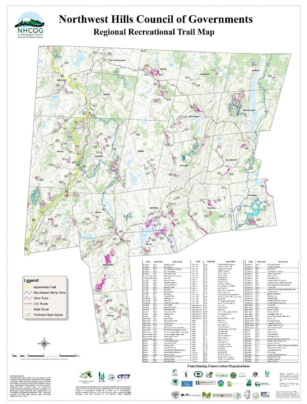
4 Project Description and Deliverables The Housatonic Valley Association (HVA) was selected through a competitive bidding process by the Northwest Hills Council of Governments to provide a Regional Trail Map and Connectivity Assessment for the 21 towns and cities in its service area. This report constitutes one of the main deliverables under that contract, in addition to which the consultant has prepared both a static trails map with index and an online map viewer, referenced herein. This project was made possible with funding through the Federal Highway Administration (FHWA) and the Connecticut Department of Transportation (CTDOT) per a NHCOG-CTDOT Fiscal Year Planning Agreement. Tim Abbott, HVA s Reginal Land Protection and Greenprint Director, led the consulting team, along with Connie Manes. Greenprint Manager, and Ryan Williams, Project GIS Coordinator. They were assisted in the final month of project by Stacy Deming, newly hired as HVA s GIS Manager. The NHCOG convened an ad-hoc Trails Committee shortly after the contract was awarded, comprising elected officials, federal and municipal employees, non-profit land trust board members and staff with detailed knowledge of specific trails and expansion projects in the region. The term of the project was slightly more than 90 days, to conform to fiscal year funding requirements. The consultant is pleased to have completed all draft deliverables within that compressed time period and to submit them to the NHCOG for its consideration on July 6 th, The final deliverables include: - A Regional Trail Index Map (Map 1 in the Appendixes) that records the location and routes of the Appalachian Trail, CT Blue Blazed Hiking Trails, other official trails on state properties, municipal trails, and trails on land trust holdings where the public access is encouraged across the 21 town service area of the NHCOG. - An Excel spreadsheet with entries for each trail that appears on the Regional Trail Index map, with additional data on trail ownership, official parking areas, and any associated regional trail network. - A Priority Regional Corridor Map and Written Assessment of opportunities and constraints to enhancing connectivity along major trail corridors. This report constitutes that written assessment, and the Regional Corridor Map appears within the body of the document. - An online map viewer built using ArcGIS Online depicting the trails from the Regional Trail Index Map, together with photographs of trailheads and locations of official parking areas, together with the general routes of certain regional expansion projects. Additional information about each trail may be found using the query function, which also provides a link to the owner or manager of the trail in question. This deliverable was initially considered an additional component of the contract, but it was possible to construct the map viewer at the same time that the consultant was building the trail database in GIS and Excel. This feature has captured the imagination of the Trails Committee and its possible enhancement is discussed in the findings. 3
5 Data Collection Methodology: The Consultant and the NHCOG reached out to their respective partner networks requesting data on recreational walking and hiking trail locations in their communities, including those for which digital, GIS compatible files are available, as well as others that are represented in.pdf. or other formats or which have never been accurately delineated. HVA was able to mobilize its 24 land trust members of the Litchfield Hills Greenprint to identify the extent of local trails owned and managed by those conservation organizations and the availability of digital data. We created an Excel Spreadsheet for each trail section that we entered into ArcGIS, assigning parent trails to related sections and attribute tables including trail length, surface, location of trailheads and official parking areas, ownership and website information. We also identified trails that would require accurate GPS data to include them in our database. Our methodology for digital data collection for trail routes included collection by the consultants and trained volunteers using either hand held Garmin Etrex units or the route tracking App Strava, and a crowd-sourcing effort using Strava. We built the interactive map viewer in ArcGIS online concurrently with our trail data collection efforts. We shared our progress with the ad-hoc Trails Committee and at a regular meeting of the NHCOG and incorporated their feedback. Disclaimers: While the regional trail map and database we created is the most complete and comprehensive ever compiled for these recreational resources within the 21 town service area of the NHCOG, it may not include every trail that exists and is open to the public. Certain trails were omitted from this report at the request of a NHCOG member or the owner of the trail. These include two of the discontinued and abandoned town roads in Sharon over which the town retains a recreational access easement; the extensive privately owned trails of Great Mountain Forest in Canaan and Norfolk and Aton Forest in Norfolk and Colebrook. We also omitted trails that have been without management for such a long period that they are difficult to find and may be unsafe to use. We did not intentionally include any informal trails on State or water company lands constructed by the public without official sanction. Finally, there were one or two areas with trails that we learned about too late to include in this report but which do not materially impact its findings. These last few trails can easily be incorporated in the online map viewer in a future update. Neither the Consultant nor the NHCOG make any representation as to local trail conditions, signage, and current level of stewardship or degree of difficulty. The Public use these trails at their own risk. Some trails are located on private land. Users are asked to respect private property rights and remain on the marked trails, not following unmarked or unofficial trails that may be encountered while on one of the trail sections included in this project and its work products. None of the trails indicated in this report or its work products was surveyed with the degree of 4

6 accuracy necessary for precise location or conveyance. There is a margin of error of 20 feet for the trails digitized with Strava. Locations should be considered close but approximate. Findings: Regional and Local Hiking Trails Open to the Public The 21 towns and cities within the NHCOG service area contain an astonishing number of public walking trails: nearly 538 miles in all. Some are of national and regional significance, including 47 miles of the Appalachian National Scenic Trail, and an additional 163 miles of the Connecticut Blue Blazed Hiking Trail network. These regional trails comprise 40% of the recreation trails in the NHCOG service area and together form the backbone the long distance hiking trail system in Northwest Connecticut. The remaining 60% are local trails, ranging from shorter paths on a single preserve to densely packed networks within popular recreation areas like those of the White Memorial Foundation in Litchfield and Morris, and Steep Rock Association s preserves in Washington. Land trusts - charitable organizations that are qualified to hold full and partial conservation interest in land - protect properties containing miles of trails. Other state trails that are not part of the Blue Blazed system, municipal trails and those on private lands other than land trust holdings, account for more than 200 miles. In addition to their own trails, nonprofit conservation groups also assume management responsibility for an astonishing 238 miles of federally or state owned hiking trails, providing a major stewardship service. 5

7 Distribution: Naturally, 538 miles of recreational walking trails are not equally distributed across the NHCOG region. Nor do they afford the same conditions, accessibility to population centers or user experience. Some are challenging, uphill climbs, while others are low gradient. Some are open to non-motorized recreational use, including horses and mountain bikes. Others do not permit these activities. Some have well maintained, relatively smooth surfaces, especially those constructed over old rail beds. Others are rugged and minimally maintained. There is a great variety of trail experience available, but not of every sort in every town and city. Town Miles of Local Trails (Not BT) Total Miles of Trails Barkhamstead Burlington Canaan Colebrook Cornwall Goshen Hartland Harwinton Kent Litchfield Morris New Hartford Norfolk North Canaan Roxbury Salisbury Sharon Torrington Warren Washington Winchester Total Trail Running in Dean s Ravine, Mohawk Blue Blazed Hiking Trail Table 1: Miles of Local Trails and Total Trail Miles Per Town 6


8 Regional Trails: Except for a few miles where the Appalachian Trail enters Connecticut in Sherman, the rest of its 47 mile length in the Nutmeg State falls within three NHCOG member towns: Kent, Sharon and Salisbury. The Appalachian Trail has numerous local branch trails, particularly in Salisbury, allowing access and egress for day hikers. In Kent, more than five miles of the Appalachian Trail follow the Housatonic River the longest riverine section in its entire length from Georgia to Maine with local access from Dawn Hill Road in Sharon. Much of the scenic landscape through which the trail passes has been permanently protected in recent decades by both public and private conservation groups through acquisition or easement. Three long distance Blue Blazed Hiking Trails, in addition to the Appalachian Trail, pass through or are entirely within the NHCOG region. The Mohawk Trail complements the Appalachian Trail East of the Housatonic River with miles of hiking trail, offering connections to the Appalachian Trail in Sharon as well as extensive hiking opportunities from Canaan/Falls Village to Warren. Almost 21 miles of the Mohawk trail lie within Cornwall, and the capstone of this network is Mohawk Mountain State Forest. The Tunxis Trail runs North to South from Hartland to Burlington and beyond, with a total of 33.8 miles within the NHCOG area. It passes through and connects with other trails in Nepaug State Forest in New Hartford and Nassahegon State Forest in Burlington. The Mattatuck Trail enters Morris and Litchfield from the Southeast and runs through the vast 31 mile trail system maintained by White Memorial Foundation. It once connected the Mohawk Trail to White Memorial, and one day could do so again. 7
.")
9 The longest one-way hike that it is currently possible to make on trails within the NHCOG region comprise two long sections of the Appalachian Trail and a former section that is now part of the Blue Blazed Mohawk Trail in Cornwall (See Figure 1). The longest loop trail combines that same part of the Mohawk Trail with the remaining section of the Appalachian Trail in Sharon offering a 35 mile hike with lots of elevation gain (Figure 2). Figure 1 Figure 2 Local Trails: Not all Blue Blazed Hiking trails are regional. Some exist as local trail networks within State properties, such as Macedonia State Park in Kent, Nepaug State Forest in Torrington and People s State Forest in Barkhamsted. Others are shorter but significant linear trails, such as the Iron Trail that ascends Canaan Mountain near Beckley Furnace Historical Monument in North Canaan and enters Housatonic State Forest in Canaan/Falls Village. The Connecticut Forest & Park Association maintains the entire Blue Blazed Hiking Trail system statewide and is its leading advocate. 8

10 The owners and managers of local trails beyond state holdings tend to be municipalities, local land trusts, other private groups, or some combination of all three. Indeed, some localities have envisioned and started to implement an integrated trail network on public and private conservation land within their communities. This is particularly true in New Hartford, Goshen, Burlington and Harwinton, but is not limited to these communities. In other places, land trusts provide most of the local recreational trails within a given municipality. Proximity to Local Population Centers: The concept of park equity, that each neighborhood or residential area should be within a short walking distance of public open space, has led to planning tools to identify gaps and expand access for underserved communities. Although it has largely been considered for urban applications, the need for village centers with access to walking trails is just as significant in rural communities. Here in Northwest Connecticut, there are limited options in some of the NHCOG communities for those who live in our villages as well as urban center to take a walk on a pedestrian trail without having to drive to it. While it was not within the scope of this project to conduct a comprehensive, quantitative trail equity tool, the Consultant did measure proximity of trails to local population centers. By buffering recognized villages and urban centers by one mile (for most people less than a 30 minute walk), we were able to look at trails and trailheads falling within that distance and compare these across communities. Figure 3: Trail Equity for Salisbury and Lakeville The villages of Salisbury and Lakeville represent communities with a high degree of trail equity. The 2.1 Mile Railroad Ramble owned by the Town of Salisbury connects the two villages and is a valued local resource, while the village of Salisbury is within walking distance of both the Appalachian Trail and the 2.3 mile Dark Hollow trail system on land conserved by Salisbury Land Trust. 9
11 Other towns and villages have fewer local walking and hiking trail options. There are no dedicated walking trail systems within a mile of the center of the City of Torrington, although there are ambitious plans to expand both the Sue Grossman and Naugatuck Greenways that could one day provide such amenities to downtown residents. Sharon has no walking trail within a mile of its village center, and neither does Northfield in Litchfield. Even those that do have trails within that distance may not have trailheads allowing access to them. Some communities have very few local trails at all, or trails that see very little use and deserve to be known more widely. Although most of the hiking trails in our region are blazed and reasonably maintained, there are also a few that lack stewardship resources and have become overgrown and difficult to follow. Communities like Burlington, Kent, Washington and Cornwall each have well over 40 miles of trails, about evenly divided between regional or blue blazed trails and local trails. Other towns like Winchester, Morris, Litchfield and Goshen have well developed local trail infrastructure but very few miles of regional trails. The ratio is reversed in Towns like Canaan/Falls Village, where almost all the recreational trails are regional and, with the exception of the Appalachian Trail, far removed from the village center, Colebrook has no Blue Blazed Hiking Trail at all, and just 1.7 miles of local trails where the public are encouraged to go. These local trails are farther away from the nearest trail system than any other trail in the 21 Towns of the NHCOG service area: 3.5 miles from hiking trails in People s State Forest, 2.5 miles from the northernmost trails in neighboring Winchester. People in rural communities often use roadsides, or even lightly travelled gravel roads themselves, as hiking trails. In some communities, the provision of additional sidewalks to facilitate access to walking opportunities in the countryside is a priority for local trail advocates. Mixed Use Passive Recreation Trails Open to the Public Although this study focused primarily on walking and hiking trails, the Consultant also noted trail section surfaces (unimproved, improved unpaved, improved paved). There are some woods roads that, while closed to vehicular traffic, are open to non-motorized transportation, including horses and mountain bikes. Although to a comprehensive assessment of trail conditions, this report can make general observations about mixed use recreational trail options within the 21 Towns of the NHCOG service area. A.D.A. Accessible, paved surface: Very few land trust trails and only a limited number of state or municipal trails are A.D.A. accessible. Just two are paved: the Sue Grossman Still River Greenway between Torrington and 10
12 Winchester and the Farmington River Trail in Burlington. There are several wide, low gradient trails, including some of Steep Rock Association and White Memorial Foundation s woods roads, Salisbury s Railroad Ramble, Norfolk s sections of old rail bed, and certain wider trails on State parks. Equestrian Trail Riding: There is a strong trail riding culture in the southeastern towns of the NHCOG. Burlington and Harwinton in particular have miles of state forest roads that are well used by equestrians, as well as designated trails within White Memorial Foundation and Steep Rock Association. To a lesser extent, this also takes place on state forest roads in Cornwall and on Canaan Mountain, but for the most part horseback riders in the northwest corner of the State stick to quiet, rural roads. Mountain Biking: Both the Harwinton Conservation and Recreation Area and Burlington s Nassahegon State Forest have official mountain bike trails promoted and maintained by the NW CT Chapter of the New England Mountain Bike Association. Certain other trails allow non-motorized use but are not specifically designed as a mountain biking course. There are also several unofficial mountain biking trails on state property that have not yet received sanction and are not included in this report. Road Biking: The trails evaluated for this report serve pedestrian walking and hiking interests. There is a strong road biking constituency in our region, and efforts to integrate trails and roadways to allow for regional travel. These regional efforts are discussed in the recommendations section of this report. Recommendations for Regional Trail Network Expansion and Connectivity A number of new or expanded recreational trails have been proposed by various groups within the study area and are in various stages of development. Analysis of current trail distribution, amenities and gaps in equity suggests additional places where trails could be expanded and connected to broaden recreational access opportunities. The following sections of this report describe these trail projects, assess feasibility and funding potential, and make recommendations for further research and trail development. 11

13 12

14 - Hiking Trail Conceptual Projects, Sponsors, Status The East-West Trail: Connecticut Forest & Park Association (CFPA) recognizes an opportunity to connect two of Connecticut s National Scenic Trails The Appalachian Trail and the New England Trail. The East-West trail would actually stretch fifty-three miles between the Mohawk Trail in Canaan/Falls Village and the New England Trail in Simsbury, passing through and along a section of the Tunxis Trail in Barkhamsted. Such a trail would allow users of the 215-mile New England Trail to cross over to the 2,200-mile Appalachian Trail. It would also provide the first cross county hiking trail in Litchfield County connecting its eastern and western communities, connecting Cornwall, Canaan/Falls Village, Norfolk, Colebrook and Barkhamsted within the NHCOG service area. CFPA has been planning this trail for more than a decade, and continues to scout and negotiate the trail route. It has numerous public and private partners, including Connecticut s Department of Energy and Environmental Protection (CT DEEP), land trusts, municipalities, and other trail advocacy groups. The Mattatuck Connector: CFPA has a second trail connector project within the NHCOG service area. The Mohawk and Mattatuck Blueblazed Hiking Trails once joined together in northwestern Litchfield. The current terminus of the Mattatuck Trail is within White Memorial Foundation in Litchfield. The MattatuckTrail has recently been extended south from Cornwall through the eastern portion of Warren and is now quite near Rte. 202 near the Litchfield and Morris Town Lines. The Mattatuck Connector would link these two trail sections somewhere in the vicinity of Mt. Tom State Park. CFPA has been researching possible trail routes and consulting with partners. The Shepaug Rail Trail Expansion: The Shepaug Railroad was once a short line railway connecting Newtown and Litchfield Connecticut. Much of the old rail bed still exists on both public and private property, and forms part of a discontinuous hiking trail network in Roxbury and Washington. Steep Rock Association has several miles of the old railroad within its trail 13
15 network and is actively working to protect lands in the northeast part of Washington that could allow extension of the trail toward Morris and Litchfield. The potential for the Shepaug Rail Trail to link with the proposed Mattatuck Connector makes this an outstanding opportunity to provide a long distance, low gradient regional hiking trail within the NHCOG service area. The Naugatuck River Greenway: The Naugatuck River Greenway would allow pedestrian and potentially bicycle access between Stillwater Pond in Torrington and communities to the south along the Naugatuck River, the largest tributary of the Housatonic River. The former Litchfield Hills Council of Elected Officials (LHCEO) published Phase One of the Naugatuck River Greenway Assessment in 2004, with conceptual maps for trail sections in Torrington, Harwinton and Litchfield between Stillwater Pond and Rte The NHCOG continues to promote the Naugatuck Greenway and support further planning and development with its municipal members from Torrington, Harwinton and Litchfield. The Sue Grossman / Naugatuck Greenway Connector: The Sue Grossman Greenway in Torrington and Winchester is one of just two extensive paved surface hiking trails within the NHCOG service area (the Farmington River Trail in Burlington is the other). The Torrington Trails Network, affiliated with NWCT YMCA, and other municipal partners from Torrington, Winchester and Barkhamsted, envisions an extension of the Sue Grossman Greenway that would connect to the Naugatuck Greenway in Torrington and pass through Winchester into Barkhamsted. Some of the preliminary planning has been done and the construction of new portions of this regional trail connector are anticipated in the next few years. The Housatonic Riverbelt Greenway: The State of Connecticut officially recognized the Housatonic Riverbelt Greenway in 2001, but the Housatonic Valley Association has been promoting this concept for the river in Connecticut since A mix of public and private land along the Housatonic River for its entire length in Connecticut, the Housatonic Riverbelt greenway contains formal and informal pedestrian, bicycle and boat access at various points along the river. It complements and intersects with other local and regional road and trail networks. The North Canaan Housatonic River Recovery Trail: Alone among the NHCOG members that contain or abut portions of the Housatonic River mainstem, the Town of North Canaan has no public access to its riverfront. There is no pedestrian trail, nor any canoe access point within the town. The old Philadelphia, Reading & New England Railroad once ran West from North Canaan s historic Union Station, crossing the Blackberry River and the Housatonic before continuing on through Salisbury. There are relatively few properties along the old railbed, and it might be possible to negotiate access easements with willing landowners to reestablish a connection between the town and the river. There is no organized effort as yet to investigate this possibility, but there are potential sources of federal funding that could help such a project get 14

16 underway. These funding possibilities are discussed in a subsequent section of this report. The Robbin s Swamp Trail: Robbins Swamp is the largest inland wetland in Connecticut. Neither North Canaan nor Canaan/Falls Village has hiking trail access to this extraordinary resource. The Robbins Swamp Wildlife Management Area owned and managed by CT DEEP has two parking areas with kiosks on Rte. 7 in North Canaan and Point of Rocks Rd. in Canaan/Falls Village, but no developed trail infrastructure. Although some of the wetland habitat in Robbin s Swamp is rare and sensitive, a well-conceived and property constructed boardwalk could be designed and implemented at either parking location. The Goshen Connector: The topography of Northwest Connecticut lends itself to North/South travel through its river valleys rather than East/West travel over its peaks and uplands. The Town of Goshen and Goshen Land Trust have developed a local trail system that allows for nearly continuous travel along 3.3 miles in the southeastern part of town. Our analysis suggests that it might be possible to identify one or more routes that could continue this trail network and bring it into Torrington, possibly connecting to the Naugatuck Greenway. More research is needed but the benefits of such a trail connector would be a substantial increase in trail equity for both communities. - Additional Recreational / Historic Trails The HouBike Trail: Divided into 10 segments, the 45 mile HouBike Trail passes from the Massachusetts/Connecticut line to New Milford, Connecticut. Sponsored by the Upper Housatonic Valley National Heritage Area, the HouBike Trail makes use of secondary roads and trails for most of its length. A 7.15 mile stretch between Cornwall and Kent is presently under consideration for rerouting off Rte 7 and onto a mix of public and private property. The potential for rails with trails along the Housatonic Railroad corridor has also been considered. 15

17 The Burgoyne / Convention Army Trail: In 1778, more than 4,300 British and German prisoners from the Battle of Saratoga were marched through Connecticut to an internment camp in Virginia. Local militia and Continental soldiers escorted these soldiers, who had surrendered under the Saratoga Articles of Convention and were therefore known as Convention Troops, through Northwest Connecticut between Enfield and Sharon. A 2010 report to the State Archeologist entitled Documentary Evidence of the Route and Encampments of the Convention Army in Connecticut provides an excellent foundation for the creation of a Burgoyne / Convention Army Trail similar to the Rochambeau Trail further to the south in Connecticut. It would follow existing roads and include interpretive signs in each community where the prisoners camped. Tim Abbott, the primary author of this paper, is also the primary researcher of the Burgoyne/Convention Army Trail. His paper has been accepted for inclusion in the collections of the David Library of the American Revolution. Feasibility, Funding - Transportation Investment Generating Economic Recovery (TIGER) Grants: The U.S. Department of Transportation still maintains its TIGER grant program, first initiated as part of the federal stimulus package in TIGER Grants may be used for greenways, rail trails, and other substantial recreational infrastructure projects, and can mean millions of dollars for recipient projects. The NHCOG and its trail partners should strongly consider submitting a 2018 TIGER Grant for one or more of the substantial trail infrastructure expansion and connectivity projects described in this report. - Recreational Trails Program: The National Recreational Trails Program (RTP) was formerly a useful source of pass-through Department of Transportation funding for Connecticut 16
18 administered through DEEP s Recreational Trails Program. Although authorized nationally through 2020, Connecticut withdrew from the program, citing the desirability of creating its own recreational trail program with funding from the bond commission. The current state budget eliminates funding for the State recreational trails program. It is hoped that Connecticut will reinvest in the program in the near future. - Conservation Easements That Require Public Access: Although not specifically funding sources for recreational trails, most federal and state grants to purchase conservation easements on private property require provision for public access. Municipalities and land trusts are eligible to apply for Open Space Watershed and Land Acquisition (OSWLA) grants from DEEP for both fee and easement purchases. The Land Trust community in Northwest Connecticut has been successful in securing both OSWLA grants and federal Highlands Conservation Act funding, often totaling 90% of the purchase price of protected lands or easements. As long as DEEP continues to have annual OSWLA grant rounds, carefully drafted applications have an excellent chance of being funded. Those in Northwest Connecticut working to expand and connect trails by acquiring conservation interest in land could make use of these grant programs to accomplish their projects, though actual trail development funding would have to come from other sources. Further Research and Development Many trail users love a rugged trail: a low-traffic footpath, unknown to the crowds, the very definition of off the beaten path. These users will find their trails regardless of the tools we create. Our analysis focuses on enhancing opportunities and user experience for the rest of the general public: (i) (ii) (iii) (iv) (v) enriching communities through enhanced connectivity within town centers and from town centers to trails enriching recreational tourism through expansion and creation of longer, landscapetraversing trails enhancing trail experience by addressing on-the-ground needs including parking, accessibility, trail markers and surface (unimproved, improved/unpaved, paved). increasing opportunities for non-foot use including ADA, bike, and water trails enhancing trail experience through improved mapping and web-accessibility This report identifies current and conceptual trail networks that could be further developed with additional research and funding support. Local trail equity could be further evaluated through public engagement in communities with few local recreational trails in proximity to town centers to determine whether providing such amenities would be welcome. A TIGER grant for 2018 offers a tremendous opportunity for the region but will require coordination and active preparation to be successful. The interactive map viewer prepared by HVA as the final 17

19 deliverable under this contract could be further enhanced with Apps that allow for handheld navigation against a preserve map and other features. The consultants wish to thank the members of the NHCOG, its ad hoc Trails Committee, and our conservation partners for the opportunity to work together on this project, and look forward to continuing to build on these recommendations in the future. Macedonia State Park, Cobble Mountain 18
20 Appendixes 19
21 Local Trails and Equity Analysis (Village town centers were determined by Post Office Locations and local knowledge.) Barkhamsted: Total Miles of Trails: Local Trails: 16.8 Miles Barkhamsted/Riverton has 1 trail system within a mile of town: Trail Name: Peoples State forest Trail Length: 30 miles of multiple loops Burlington: Total Miles of Trails: Local Trails: 23.8 Miles Burlington has multiple access points to The Tunxis Trail within a mile of town: Trail Name: Tunxis Trail and many side loops Trail Length: 40 miles of trails within the town boundary with looping side trails also access to Tunxis through Trail Canaan / Falls Village: Total Miles of Trails: 7.9. Local Trails: 0.4 Miles Falls Village has two trails within a mile of the center. Trail Name: AT Trail Length: The trail is a through trail Trail Name: Universal Access Route Trail Length:.4 Miles, when looped with the AT it is1.1 Miles Colebrook: Total Miles of Trails: 1.7 Local Trails: 1.7 Miles Colebrook has 2 trails within a mile of town center (both loops) Trail Names: Hale Trail Trail Length:.7 miles Trail Name: Rockwell Trail Trail Length:.3 miles 20
22 Cornwall: Total Miles of Trails: Local Trails: 16.1 Miles Cornwall Bridge has two trail systems within a mile of the center: Trail Name: Mohawk Trail Trail Length: 20 mile through trail Trail Name: Mohawk Trail (to AT) Trail Length:.9 miles to AT Cornwall Village has two trail systems within a mile of the center: Trail Name: Ballyhack Trail Trail Length:.5 miles (loop) Trail Name: Mohawk Trail Trail Length: 20 mile through trail West Cornwall has one trail system within a mile of the village center: Trail Name: Day Preserve Trail Length: 1 mile one way trail Goshen: Total Miles of Trails: Local Trails: 9.3 Miles There are two trails within a mile of Goshen town center: Trail Name: Richard Kobylenski WPRA Trail Length:.9 miles (one way trail) Trail Name: Fox Brook Preserve Trail Length:.6 miles of loops 21
23 Hartland: Total Miles of Trails: Local Trails: 0.9 Miles West Hartland has no trails within a mile. East Hartland has one trail within a mile: Trail Name: Unnamed Trail Length:.9 mile loop Harwinton: Total Miles of Trails: 10.3 Local Trails: 14.5 Miles Harwinton has three trails within 1 mile of town center: Trail Name: Harwinton Conservation/Recreation Area Trail Length 5.3 miles of multiple loops Trail Name: Forever Forest Trail Length:.75 miles of loops Trail Name: Bull Pond Preserve Trail Length: 1.3 Miles of loops Kent: Total Miles of Trails: Local Trails: 25.4 Miles Kent has one trail within a mile of town center: (Cobble Brook Vista is about 1.2 miles) Trail Name: AT The trail is a through trail, well-traveled, well-marked, well-known, promoted and cared for, parking mostly adequate. Opportunities: - A trail from town center on land trust land about 2 mi of flat land on east side Rte 7 terminating local farm with farm stand. Trail could accommodate bikes and be ADA. Litchfield: Total Miles of Trails: Local Trails: 36 Miles Bantam has two trail systems within a mile of town center: Trail Name: WM Apple Hill Trail Length: 2.15 miles (loops and ow) 22
24 Trail Name: White Memorial (various Trails) Length in Bantam: 4 miles of loops Litchfield has two trail systems within a mile of town center: Trail Name: White Memorial (various Trails) Length in Bantam: 4.3 miles of loops Trail Name: White Memorial (Vineyard Trail/River Trail) Length in Bantam: 1.5 miles of loops Northfield has no trails within a mile of town center: Morris: Total Miles of Trails: Local Trails: 21.3 Miles Morris has two rails within a mile of town center: Trail Name: WM Solnit-Skilton Trail Trail Length:.8 miles OW trail Trail Name: Camp Columbia Trail Length: 4.2 miles of loops New Harford: Total Miles of Trails: 25.7 Local Trails: 11.7 Miles New Hartford has one trail system within a mile of town: Trail Name: Jones Mtn Trail Length: 3 miles of loops Bakersville has two trails within 1 mile of the village: Trail Name: Brodie to Bakersville Trail Trail Length: 2.7 mile trough trail Norfolk: Total Miles of Trails: Local Trails: 21.4 Miles Norfolk has four trail systems within 1 mile of town center. 23
25 Trail Names: Ells Crane (.8 mile loops)/north Swamp (1.7 mile loops)/haystack Mtn (2.5 miles loops)/barbour Woods (4.8 miles of loops) North Canaan: Total Miles of Trails: 2.8. Local Trails: 1.6 Miles There are three trails/trailheads within a mile of Canaan that are all part of the N Canaan Greenway Trail Name: North Canaan Greenway Length: 1.5 miles accessible from center East Canaan Trail Locations: Trail Name: Iron Trail Trail Length: 3.5 Miles into the Town of Canaan on Canaan Mountain. It is a one way hike. Roxbury: Total Miles of Trails: Local Trails: 23.9 Miles Roxbury has one trail system within a mile of town center: Trail Name: Tierney Loop Trail Length:.35 miles loop Salisbury: Total Miles of Trails: Local Trails: 14 Miles The village of Lakeville has one trail within a mile of the village center. Trail Name: Railroad ramble Trail Length: 2.1 miles The trail is one way connecting to the AT The village of Salisbury (Rt 41/45 Intersection) has three trails within a mile: Trail Name: Railroad ramble Trail Length: 2.1 miles The trail is one way connecting to the AT Trail Name: AT Trail Length: The trail is a through trail 24
26 Trail Name: Dark Hollow Trail System Trail Length: approx. 2.3 Miles The trail is a series of loops Sharon: Total Miles of Trails: Local Trails: 26.4 Miles Sharon has no trails within a mile of town center: Torrington: Total Miles of Trails: Local Trails: 11.8 Miles There are no trail systems within a mile of Torrington city center: Warren: Total Miles of Trails: Local Trails: 3.1 Miles Warren has three trail systems within a mile of town center: Trail Name: Wyantenock State Grassi Road Trail Length:.7 mile one way trail Trail Name: Above All State Park Trail Length:.2 miles one way Trail Name: Coords Preserve Trail Length: 1.9 miles one way connecting to The Mattatuck Trail Washington: Total Miles of Trails: 44.2 Local Trails: 44.2 Miles Washington has one rail system within a mile of town center: Trail Name: Hidden Valley Preserve Trail Length: 18.9 miles Washington Depot has one trail system within a mile of town center: Trail Name: Steep Rock (various Trails) Trail Length: 18.8 miles of loops Winchester: Total Miles of Trails: 13. Local Trails: 12.9 Miles There are no trail systems within a mile of Winsted center. 25
A CASE FOR COMPLETING THE JORDAN RIVER PARKWAY: A
 A CASE FOR COMPLETING THE JORDAN RIVER PARKWAY: A safe crossing at 9000 South and 850 West Proposed 9000 South Underpass Parkway Timeline Parkway, Trail, and Tourism Facts Blueprint Jordan River 1971 1973
2. Goals and Policies. The following are the adopted Parks and Trails Goals for Stillwater Township:
 D. PARKS AND TRAILS 1. Introduction Stillwater Township s population is relatively low, with most residents living on rural residences on large lots. The need for active park space has been minimal in
Blueways: Rivers, lakes, or streams with public access for recreation that includes fishing, nature observation, and opportunities for boating.
 Parks, Open Space and Trails PRINCE WILLIAM COUNTY 2008 COMPREHENSIVE PLAN TRAILS PLAN CONTENTS The components of the trails plan are: Intent Definitions Goals, Policies, and Action Strategies Trails Map
APPENDIX OFFICIAL MAP ORDINANCE OF HAMILTONBAN TOWNSHIP OFFICIAL MAP NARRATIVE
 APPENDIX A OFFICIAL MAP ORDINANCE OF HAMILTONBAN TOWNSHIP OFFICIAL MAP NARRATIVE INTRODUCTION: The Official Map of Hamiltonban Township has been prepared to identify those lands and features that Hamiltonban
Section II. Planning & Public Process Planning for the Baker/Carver Regional Trail began in 2010 as a City of Minnetrista initiative.
 Section II Planning & Public Process Planning for the began in 2010 as a City of initiative. city staff began discussions with the Park District on the possibility of a north/south regional trail connection
AGENDA ITEM 5 D WAKULLA ENVIRONMENTAL INSTITUTE (WEI) TRAIL FEASIBILITY STUDY
 TRAIL FEASIBILITY STUDY") March 19, 2018 AGENDA ITEM 5 D WAKULLA ENVIRONMENTAL INSTITUTE (WEI) TRAIL FEASIBILITY STUDY TYPE OF ITEM: Action STATEMENT OF ISSUE The Wakulla Environmental Institute (WEI) Trail is one of several trails
March 19, 2018 AGENDA ITEM 5 D WAKULLA ENVIRONMENTAL INSTITUTE (WEI) TRAIL FEASIBILITY STUDY TYPE OF ITEM: Action STATEMENT OF ISSUE The Wakulla Environmental Institute (WEI) Trail is one of several trails
Preferred Recreation Recommendations Stemilt-Squilchuck Recreation Plan March 2018
 Preferred Recreation Recommendations Stemilt-Squilchuck Recreation Plan March 2018 Below are the recommended recreation ideas and strategies that package together the various recreation concepts compiled
Trails. Lois Jensen Nature Preserve is a 30 acre parcel on the north end of the city. It provides unspoiled wooded paths.
 Trails Lois Jensen Nature Preserve is a 30 acre parcel on the north end of the city. It provides unspoiled wooded paths. TRAIL S, PATHS, ROUTES AND CONNECTORS Citizen input pointed to trails, paths, bike
FEASIBILITY CRITERIA
 This chapter describes the methodology and criteria used to evaluate the feasibility of developing trails throughout the study areas. Land availability, habitat sensitivity, roadway crossings and on-street
DRAFT - APRIL 13, 2007 ROUTING STUDY FOR TRAIL CONNECTIONS BETWEEN CALAIS AND AYERS JUNCTION
 DRAFT - APRIL 13, 2007 ROUTING STUDY FOR TRAIL CONNECTIONS BETWEEN CALAIS AND AYERS JUNCTION Abstract The vision for the East Coast Greenway is an off-road urban trail system running from Calais, Maine
White Mountain National Forest Saco Ranger District
 United States Department of Agriculture Forest Service White Mountain National Forest Saco Ranger District 33 Kancamagus Highway Conway, NH 03818 Comm: (603) 447-5448 TTY: (603) 447-3121 File Code: 1950
The Recreational Trail along Cushing Park road has been a successful addition to the city
 The Recreational Trail along Cushing Park road has been a successful addition to the city Trails TRAILS, PATHS, ROUTES AND CONNECTORS Citizen input pointed to trails, paths, bike routes, and other non-motorized
FAQ: HR 799 & S. 403: North Country National Scenic Trail Route Adjustment Act
 FAQ: HR 799 & S. 403: North Country National Scenic Trail Route Adjustment Act Exactly what does HR 799/S. 403 call for? These bills simply amend the National Trails System Act (16 U.S.C. 1244(a)(8)) by:
3.0 LEARNING FROM CHATHAM-KENT S CITIZENS
 3.0 LEARNING FROM CHATHAM-KENT S CITIZENS An important aspect in developing the Chatham-Kent Trails Master Plan was to obtain input from stakeholders and the general public. Throughout the course of the
Chapter 6: POLICY AND PROCEDURE RECOMMENDATIONS
 Chapter 6 POLICY AND PROCEDURE RECOMMENDATIONS FOR SRRA Below are seven policy elements that should be considered for adoption by the Southwest Regional Recreation Authority of Virginia: 1. Develop strategies
RE: Access Fund Comments on Yosemite National Park Wilderness Stewardship Plan, Preliminary Ideas and Concepts
 September 30, 2016 Superintendent Yosemite National Park Attn: Wilderness Stewardship Plan P.O. Box 577 Yosemite, CA 95389 RE: Access Fund Comments on Yosemite National Park Wilderness Stewardship Plan,
Continental Divide National Scenic Trail Legislative History and Planning Guidance
 Continental Divide National Scenic Trail Legislative History and Planning Guidance Legislation, Policy, and Direction Regarding National Scenic Trails The National Trails System Act, P.L. 90-543, was passed
To find your town, click on the name in the list below
 Map of Litchfield County, Connecticut 1859 To find your town, click on the name in the list below BARKHAMSTED BETHLEHEM BRIDGEWATER CANAAN COLEBROOK CORNWALL GOSHEN HARWINTON KENT LITCHFIELD MORRIS NEW
Economic Development and Tourism
 SECTION 4 SECTION 4 Economic Development and Tourism 4. Economic Development and Tourism Tourism plays a very important role in Niagara s economy, providing employment and generating business for support
Welcome to the Cross County Trail Public Input Session!
 Welcome to the Cross County Trail Public Input Session! Please sign in on the table below! What are we doing here? Camden County has proposed a bicycle and pedestrian trail spanning across the entire county.
Naugatuck River Greenway Steering Committee
 This letter is being submitted in strong support of the City of Ansonia s application to the Department of Energy and Environmental Protection Recreational Trails Program for the funding to conduct a routing
Waukee Trailhead Public Art and Amenities Project
 Waukee - Trailhead Public Art and Amenities Project Sponsor Waukee Project Title Waukee Trailhead Public Art and Amenities Project Termini Description ( i.e. Park Avenue to 19th Street) NE Intersection
Segment 2: La Crescent to Miller s Corner
 goal of the USFWS refuges is to conserve, protect and enhance fish, wildlife and plants and their habitats for the continuing benefit of the American people. Refuge lands are used largely for fishing,
3. COLTA / HUGA CONNECTIONS - PRELIMINARY
 9 3. COLTA / HUGA CONNECTIONS - PRELIMINARY 3.1 COLTA The Chain of Lakes Trail Association (COLTA) trail, formerly identified as the Chester Spur Line, was completed and opened for use in June 2011. The
Appendix 3. Greenway Design Standards. The Whitemarsh Township Greenway Plan
 Appendix 3 Greenway Design Standards This chapter discusses two design standards for the greenway types discussed above. First, trail design standards are presented together with trailhead facilities and
CHAPTER 4 -- THE LAND USE PLAN: DESCRIPTIONS AND POLICIES FOR THIRTEEN PLANNING AREAS
 CHAPTER 4 -- THE LAND USE PLAN: DESCRIPTIONS AND POLICIES FOR THIRTEEN PLANNING AREAS NORTH CENTRAL CAC AREA LITTLE VALLEY ROAD TO JUG HANDLE CREEK PLANNING AREA This planning area includes Cleone, Noyo,
Mohawk Hudson Bike Hike Trail Crossroad Connection Study
 Summary Report - April 21, 2003 Mohawk Hudson Bike Hike Trail Crossroad Connection Study Summary Report Introduction The Capital District Transportation Committee (CDTC), in partnership with Albany County,
Georgetown-Lewes Rail/Trail Study. Rail/Trail Study: Cool Spring to Cape Henlopen State Park New Road Extension (House Resolution No.
 Georgetown-Lewes Rail/Trail Study Rail/Trail Study: Cool Spring to Cape Henlopen State Park New Road Extension (House Resolution No. 47) August 22, 2011 Presentation Outline Background Benefits Statewide
4.19 Parks, Recreation, and Conservation Lands
 interchange would have on the Reed Paige Clark Homestead located on the north side of Stonehenge Road. Alternative D would also affect Palmer Homestead, E.F. Adams House, and Knapp Brothers Shoe Manufacturing
S Central Coast Heritage Protection Act APRIL 21, 2016
 STATEMENT OF GLENN CASAMASSA ASSOCIATE DEPUTY CHIEF, NATIONAL FOREST SYSTEM U.S. FOREST SERVICE U.S. DEPARTMENT OF AGRICULTURE BEFORE THE UNITED STATES SENATE COMMITTEE ON ENERGY AND NATURAL RESOURCES
11. Recreational Trails and Pathways Needs
 11. Recreational Trails and Pathways Needs Background Walking, biking, hiking, in-line skating, canoeing, and other trail- and pathway-related activities are important to Boiseans. This importance is demonstrated
Proposal to Redevelop Lower Kananaskis River-Barrier Lake. Bow Valley Provincial Park. Frequently Asked Questions
 Proposal to Redevelop Lower Kananaskis River-Barrier Lake Bow Valley Provincial Park Frequently Asked Questions What is being proposed? What are the details of the proposal? Where is the project area located?
City of Durango 5.8 FUNDING TRAILS DEVELOPMENT
 5.8 FUNDING TRAILS DEVELOPMENT The City has been successful in establishing dedicated local funding sources as well as applying for grants to develop the City s trail system, having received nearly $2.4
MASTER PLAN EXECUTIVE SUMMARY
 Biscuit Run State Park Scottsville Road (State Route 20) Charlottesville, VA 22902 Biscuit Run State Park MASTER PLAN EXECUTIVE SUMMARY Department of Conservation and Recreation Division of Planning and
Northeast Quadrant Distinctive Features
 NORTHEAST QUADRANT Northeast Quadrant Distinctive Features LAND USE The Northeast Quadrant includes all the area within the planning area that is east of Interstate 5 and to the north of State Route 44.
Environment and Natural Resources Trust Fund 2019 Request for Proposals (RFP)
") Environment and Natural Resources Trust Fund 2019 Request for Proposals (RFP) Project Title: Glacial Edge Trail and Downtown Pedestrian Bridge Category: G. Land Acquisition for Habitat and Recreation ENRTF
Environment and Natural Resources Trust Fund 2019 Request for Proposals (RFP) Project Title: Glacial Edge Trail and Downtown Pedestrian Bridge Category: G. Land Acquisition for Habitat and Recreation ENRTF
THOMAS A. SWIFT METROPARK Introductions History Present Conditions Future Development Plans Implementation Strategies Statistics
 THOMAS A. SWIFT METROPARK Introductions History Present Conditions Future Development Plans Implementation Strategies Statistics Introduction As an open meadow park positioned along the Mahoning River,
Blue River Trail Master Plan JSA to Town Hall June 2004
 Blue River Trail Master Plan JSA to Town Hall June 2004 Prepared for: Silverthorne Town Council Silverthorne SPORT Committee Department of Recreation and Culture Silverthorne Public Works Silverthorne
2016 Regional Transportation Alternatives Program (TAP) Grant Application
 Grant Application") 2016 Regional Transportation Alternatives Program (TAP) Grant Application PROJECT TITLE: Yelm-Tenino Trail Extension Feasibility Study TRPC use only GENERAL PROJECT INFORMATION Agency or Organization City
2016 Regional Transportation Alternatives Program (TAP) Grant Application PROJECT TITLE: Yelm-Tenino Trail Extension Feasibility Study TRPC use only GENERAL PROJECT INFORMATION Agency or Organization City
Procedure for the Use of Power-Driven Mobility Devices on Mass Audubon Sanctuaries 1 September 17, 2012
 Procedure for the Use of Power-Driven Mobility Devices on Mass Audubon Sanctuaries 1 September 17, 2012 Background As part of Mass Audubon s mission to preserve the nature of Massachusetts for people and
CHAPTER 5. Chapter 5 Recreation Element
 CHAPTER 5 Recreation Element Chapter 5 Recreation Element The Recreation Element of the Meyers Area Plan is a supplement to the Recreation Element of the TRPA Regional Plan and the El Dorado County General
PURPOSE AND NEED (CONCURRENCE POINT 1) NEW CANADA ROAD PROJECT FROM STATE ROUTE 1 (U.S. HIGHWAY 70) TO U.S. INTERSTATE 40
 NEW CANADA ROAD PROJECT FROM STATE ROUTE 1 (U.S. HIGHWAY 70) TO U.S. INTERSTATE 40") PURPOSE AND NEED (CONCURRENCE POINT 1) NEW CANADA ROAD PROJECT FROM STATE ROUTE 1 (U.S. HIGHWAY 70) TO U.S. INTERSTATE 40 Project Description The primary purpose of this project is to improve the major
PURPOSE AND NEED (CONCURRENCE POINT 1) NEW CANADA ROAD PROJECT FROM STATE ROUTE 1 (U.S. HIGHWAY 70) TO U.S. INTERSTATE 40 Project Description The primary purpose of this project is to improve the major
Non-Motorized Transportation
 Non-Motorized Transportation Non-motorized facilities are important components to the transportation system. They provide an environmentally-friendly, low-cost mode of travel. Some of the facilities can
Logo Department Name Agency Organization Organization Address Information 5700 North Sabino Canyon Road
 Logo Department Name Agency Organization Organization Address Information United States Forest Coronado National Forest 5700 North Sabino Canyon Road Department of Service Santa Catalina Ranger District
ALBANY-HUDSON ELECTRIC TRAIL FEASIBILITY STUDY. Final Report OCTOBER 2011
 ALBANY-HUDSON ELECTRIC TRAIL FEASIBILITY STUDY Final Report OCTOBER 2011 ALBANY-HUDSON ELECTRIC TRAIL FEASIBILITY STUDY Prepared for: Town of East Greenbush 225 Columbia Turnpike Rensselaer, New York 12144
Lafourche Parish Government REQUEST FOR QUALIFICATIONS. Landscape Architectural Services
 Lafourche Parish Government REQUEST FOR QUALIFICATIONS Landscape Architectural Services Bayou Lafourche Parish Multi-Use Path Feasibility Study Phase 1 And Bayou Lafourche Parish Multi-Use Path Feasibility
Gardner: overview. Santa Fe, Oregon, and California National Historic Trails UNINCORPORATED JOHNSON COUNTY OLATHE UNINCORPORATED JOHNSON COUNTY
 Santa Fe, Oregon, and California ational Historic Trails : overview 99: p.134 100: p.135 GARDER JUCTIO 102: p.137 56: p.126 EDGERTO Burlington orthern Intermodal and Logistics 98: p.133 101: p.136 S Waverly
Public Informational Meeting
 Public Informational Meeting April 17, 2007 Bow-Concord I-93 I Transportation Planning Study Bow-Concord Interstate 93 Transportation Planning Study Context Sensitive Solutions Planning Steps Screen Alternatives
RUSHMORE CONNECTOR TRAIL PROPOSAL
 PURPOSE AND NEED Background The U.S. Forest Service, Black Hills National Forest (Forest Service) has received a special use permit application from the State of South Dakota Department of Game, Fish and
Digital Terrain Analysis of Archer Mountain
 Digital Terrain Analysis of Archer Mountain Identifying a potential new recreational trail Photo: Justin Bush GEOG 593 - Duh Marcus Tobey Justin Bush Project Overview Background Project Area Overview Questions
Rivanna Trails Foundation
 a project of the Rivanna Trails Foundation Source www.rivanna.avenue.org Who we are The mission of the Rivanna Trails Foundation (RTF) is to create, promote the creation of, and protect footpaths, trails
Wallace Falls State Park Classification and Management Planning Stage 3 Preliminary Recommendations July 18, 2018 Sultan City Hall
 Wallace Falls State Park Classification and Management Planning Stage 3 Preliminary Recommendations July 18, 2018 Sultan City Hall Thanks for coming! This document contains State Parks preliminary recommendations
Chapter 2: Summary of Existing Open Space System
 Chapter 2: Summary of Existing Open Space System In 1976, the Wake County Board of Commissioners established the Wake County Parks and Recreation Department in order to provide park facilities and programs
13.1 REGIONAL TOURISM ISSUES AND SUMMARY OF FINDINGS
 13 REGIONAL TOURISM T he County of Mariposa s recreation needs and facilities fall within two categories: regional tourism and local recreation. This Element focuses on regional tourism issues related
Draft Concept Alternatives Analysis for the Inaugural Airport Program September 2005
 Section 10 Preferred Inaugural Airport Concept 10.0 Introduction The Preferred Inaugural Airport Concept for SSA was developed by adding the preferred support/ancillary facilities selected in Section 9
This page has been intentionally left blank.
 This page has been intentionally left blank. Chapter 2 2-2 2. Growing the Economy In many ways, the Niagara Region is a community of communities and this is becoming increasingly so. It is made up of towns
United States Department of the Interior National Park Service. Boundary Expansion Listed in National Register January 11, 2017
 NPS Form 10900-a (Rev. 8/2002) OMB No. 10240018 United States Department of the Interior National Park Service Boundary Expansion Listed in National Register January 11, 2017 National Register of Historic
APPENDIX B: NPIAS CANDIDATE AIRPORT ANALYSIS
 APPENDIX B: NPIAS CANDIDATE AIRPORT ANALYSIS The National Plan of Integrated Airport Systems (NPIAS) is the Federal Aviation Administration s (FAA) national airport plan. The NPIAS includes nearly 3,500
Business Item No
 Metropolitan Parks and Open Space Commission Meeting date: February 6, 2018 For the Community Development Committee meeting of February 20, 2018 For the Metropolitan Council meeting of February 28, 2018
Port Gamble Shoreline Area Conceptual Trail Proposal
 The North Kitsap Trails Association is pleased to be a partner to the Kitsap Forest and Bay Project and assist Kitsap County, Forterra, Olympic Property Group, Great Peninsula Conservancy and the Port
Mt. Hood National Forest
 United States Department of Agriculture Forest Service Mt. Hood National Forest Zigzag Ranger District 70220 E. Highway 26 Zigzag, OR 97049 503-622-3191 Fax: 503-622-5622 File Code: 1950-1 Date: June 29,
4.0 Context for the Crossing Project
 4.0 Context for the Crossing Project This section provides background information about key features of the North Douglas Crossing project area, and opportunities and constraints. This information is important
Trail # NW Tuesday, June DESIGN. Provide an Review the Provide an. Project Goals: System system. wayfinding
 I. Welcome / Introductions Bethany Creek Trail #2 Segment 3 Neighborhood Meeting #1 Bethany Presbyterian Church 15505 NW Springville Road, Portland, OR 97229 Tuesday, June 26, 2018 @ 6:00PM Meeting Minutes
Regional Wayfinding Sign Strategy Thurston County Trails 2017
 Regional Wayfinding Sign Strategy Thurston County Trails 2017 Partners: Members and partnering organizations of the Thurston Thrives Community Design Action Team City of Lacey, City of Olympia, City of
APPENDIX A1. NATIONAL TRAILS SYSTEM
 APPENDIX A1. NATIONAL TRAILS SYSTEM Acts of October 2, 1968 (PL 90-543), Nov. 10, 1978, March 28, 1983 (PL 98-11), Dec. 11, 1987 (PL 100-187), Oct. 4, 1988 (PL 100-470), 2006 (PL 109-418). 16 USC 1241-1251.
TRAIL DATABASE SCHEMA (8/26/2014)
") Trail Data Model for LINES Source Data Source Agency dataagency Agency or entity that created the dataset where the original line was sourced from. Source Date of Last Data Used to Update sourcedate Publication
Trail Data Model for LINES Source Data Source Agency dataagency Agency or entity that created the dataset where the original line was sourced from. Source Date of Last Data Used to Update sourcedate Publication
Exploring State Water Trail Programs
 National Park Service U.S. Department of the Interior Rivers, Trails, and Conservation Assistance Program Exploring State Water Trail Programs Barbara Nelson- Jameson Corita Waters Jessie Egan E X P E
APPENDIX A: Survey Instruments
 Three different surveys were conducted during the research phase of the NCHA Trails Study. One questionnaire was designed for elected officials and user groups (general public). The other two questionnaires
chapter - Hex Highway Touring Route Hamburg to Strausstown Overview
 chapter - 2 Hex Highway Touring Route Hamburg to Strausstown Overview The on-road Hex Highway automobile and bicycle touring route begins on State Street in downtown Hamburg. The route continues west on
Committee Report. Community Development Committee For the Metropolitan Council meeting of April 13, Business Item No.
 Committee Report Business Item No. 2016-48 Community Development Committee For the Metropolitan Council meeting of April 13, 2016 Subject: Harriet Island-South St. Paul Regional Trail Master Plan, Saint
Chapter 6. Trail Design. Trail Design
 Chapter 6 Trail Design Trail Design The trail winds through a region rich in scenic beauty, cultural, and natural history. Volunteer landscape architects working with the Core and Planning Teams, have
At the time, the portion of the line through Eagle County remains wholly under the ownership of Union Pacific Railroad (UP).
.") Chapter 5 The Railroad Corridor as a Trail Corridor The intent of this chapter is to identify how the rail corridor, if available for lease or purchase in all or part, could be incorporated into the core
Chapter 5 The Railroad Corridor as a Trail Corridor The intent of this chapter is to identify how the rail corridor, if available for lease or purchase in all or part, could be incorporated into the core
Committee. Presentation Outline
 CW-33-15 11/9/2015 Community and Corporate Services Committee November 10, 2015 1 Presentation Outline Background Vision and Objectives Study Process and Timeline Public and Stakeholder Engagement Organization
Tracy Ridge Shared Use Trails and Plan Amendment Project
 Tracy Ridge Shared Use Trails and Plan Amendment Project Scoping Document Forest Service Allegheny National Forest Bradford Ranger District McKean, County, Pennsylvania In accordance with Federal civil
Coast to Coast Connector Summit
 Project Partners Welcome to the Coast to Coast Connector Summit Winter Garden, Florida City Hall October 1, 2014 1 Why are we here? Objectives 1. Inform key stakeholders on the current state of the C2C
University Region Non-Motorized Plan 2015
 Non-Motorized Transportation Non-motorized facilities are important components to the transportation system. They provide an environmentally-friendly, low-cost mode of travel. Some of the facilities can
EXECUTIVE SUMMARY PROGRAM DEVELOPMENT REPORT PURPOSE EXISTING SETTING EXPANDING PARKLAND
 EXECUTIVE SUMMARY PROGRAM DEVELOPMENT REPORT PURPOSE As the culmination of the first phase of the master planning process, this Program Development Report creates the framework to develop the Calero County
Proposal to Redevelop Lower Kananaskis River-Barrier Lake. Bow Valley Provincial Park
 Frequently Asked Questions Proposal to Redevelop Lower Kananaskis River-Barrier Lake Bow Valley Provincial Park Frequently Asked Questions What has been decided? What are the details of the plan? What
New England National Scenic Trail. Land and Water Conservation Fund FY2014 Request
 New England National Scenic Trail Land and Water Conservation Fund FY2014 Request National Trails System Land and Water Conservation Fund FY2014 New England National Scenic Trail Tanager Hill Penwood State
The Chu property is a 6.57 acre parcel located in the Town of Superior on the west side of McCaslin Boulevard. In 2014, the Town of Superior acquired
 1 The Chu property is a 6.57 acre parcel located in the Town of Superior on the west side of McCaslin Boulevard. In 2014, the Town of Superior acquired the Chu property for open space with a contribution
Stephens Rd. Nature Preserve
 Stephens Rd. Nature Preserve History Stephens Road Nature Preserve (SRNP) is a 350-acre nature preserve in Huntersville that comprises nine properties purchased between 1994 and 2008. Parcels included
The Future of the Road to Revolutions. A Battle Road Scenic Byway Public Forum November 9, 2010
 The Future of the Road to Revolutions A Battle Road Scenic Byway Public Forum November 9, 2010 Who is the Battle Road Scenic Byway? Four Towns: Arlington, Lexington, Lincoln, Concord Minute Man National
Chapter 1: Introduction
 Chapter 1: TABLE OF CONTENTS 1... 4 1.1 Master Plan Study Content... 4 1.2 Purpose and Scope of Master Plan Study... 4 1.3 Airport History and Role... 6 1.4 Airport Location and Service Area... 6 1.5 ABIA
Chapter 6. Action Program. Heart of the Lakes Area Recreation Plan
 Heart of the Lakes Area Recreation Plan 1. Design and construct the following trails (please see the following map): a. the Speedway Trail 1) primary pathway the main trail 2) secondary pathway the proposed
Classifications, Inventory and Level of Service
 Classifications, Inventory and Level of Service Section 3 Kenmore Park, Recreation and Open Space Plan 1 P a g e Classifications and Inventory Park Classifications Kenmore classifies its parks based upon
PROPOSED PARK ALTERNATIVES
 8 Chimne y Rock State Park M a ster Pl an 2011 PROPOSED PARK ALTERNATIVES Introduction Three different park development concepts were prepared and presented to the citizens of North Carolina through a
$866,000. $1,400,000 Health Benefits $13,156,000 TOTAL ANNUAL DIRECT BENEFITS. $10,890,000 Economic Benefits
 SINGING RIVER TRAIL Trails Create Value + Generate Economic Activity Trails generate economic returns through improved health, safety, and environmental conditions, raise property values, and attract visitors.
FINAL TESTIMONY 1 COMMITTEE ON RESOURCES UNITED STATES HOUSE OF REPRESENTATIVES. July 13, 2005 CONCERNING. Motorized Recreational Use of Federal Lands
 FINAL TESTIMONY 1 STATEMENT OF DALE BOSWORTH CHIEF Of the FOREST SERVICE UNITED STATES DEPARTMENT OF AGRICULTURE Before the SUBCOMMITTEE ON FORESTS AND FOREST HEALTH And the SUBCOMMITTEE ON NATIONAL PARKS,
12, 14 and 16 York Street - Amendments to Section 16 Agreement and Road Closure Authorization
 REPORT FOR ACTION 12, 14 and 16 York Street - Amendments to Section 16 Agreement and Road Closure Authorization Date: April 27, 2018 To: Toronto and East York Community Council From: Senior Strategic Director,
ROAD AND TRAIL PROJECT APPROVAL
 ROAD AND TRAIL PROJECT APPROVAL www.marincountyparks.org Marin County Parks, 3501 Civic Center Dr, Suite 260, San Rafael, CA 94903 DATE: July 12, 2017 PRESERVE: Gary Giacomini Open Space Preserve PROJECT:
CHAPTER 6 NOISE EXPOSURE
 CHAPTER 6 NOISE EXPOSURE FAA requires that the NEM submitted for review represent the aircraft noise exposure for the year of submittal (in this case 2008) and for a future year (2013 for OSUA). However,
ADVENTURE PLAN EXPLORE PARK
 ADVENTURE PLAN ROANOKE COUNTY S EXPLORE PARK ROANOKE COUNTY PARKS, RECREATION AND TOURISM 1206 KESSLER MILL RD SALEM, VA 24153 (540) 387-6078 WHAT S INCLUDED? Explore Park Adventure Plan - Guided by extensive
JOSLIN FIELD, MAGIC VALLEY REGIONAL AIRPORT DECEMBER 2012
 1. Introduction The Federal Aviation Administration (FAA) recommends that airport master plans be updated every 5 years or as necessary to keep them current. The Master Plan for Joslin Field, Magic Valley
Section 4(f) and Section 6(f) Technical Analysis
 and Section 6(f) Technical Analysis") WESTSIDE SUBWAY EXTENSION PROJECT Contract No. PS-4350-2000 Section 4(f) and Section 6(f) Technical Analysis Prepared for: Prepared by: WSP USA 851 SW Sixth Avenue, Suite 1600 Portland, Oregon 97204 FEBRUARY
WESTSIDE SUBWAY EXTENSION PROJECT Contract No. PS-4350-2000 Section 4(f) and Section 6(f) Technical Analysis Prepared for: Prepared by: WSP USA 851 SW Sixth Avenue, Suite 1600 Portland, Oregon 97204 FEBRUARY
MEETING MINUTES District 1 Trail Planning Meeting 1
 MEETING MINUTES District 1 Trail Planning Meeting 1 June 1, 2017 2:00 PM 3:30 PM City of Two Harbors 2:00 Introductions Attendees: Lisa Austin, MnDOT Bryan Anderson, MnDOT Jasna Hadzic-Stanek, MnDOT Justin
The Vision for the San Juan Islands Scenic Byway
 The Vision for the San Juan Islands Scenic Byway 2 Judd Cove, Orcas Island, Courtesy of Kurt Thorson (kurtthorson.com) and San Juan County Land Bank Vision for the San Juan Islands Scenic Byway The San
This Passport: Revised October 20, 2017, EAM # Discovering the Trails of Webster, NY
 This Passport: Revised October 20, 2017, EAM #161923 Discovering the Trails of Webster, NY The Town of Webster invites you to explore and experience our diverse outdoor adventures! Here s your opportunity
The Missouri Department of Transportation is proposing to amend the state's five-year Statewide Transportation Improvement Program (STIP).
.") The Missouri Department of Transportation is proposing to amend the state's five-year Statewide Transportation Improvement Program (STIP). A 7-day public comment period regarding the amendment begins January
The Missouri Department of Transportation is proposing to amend the state's five-year Statewide Transportation Improvement Program (STIP). A 7-day public comment period regarding the amendment begins January
Snowmobile Connectors Are Disconnected
 Snowmobile Connectors Are Disconnected By Dave Gibson Adirondack Explorer MONDAY, AUGUST 10, 2015 The Boreas River and Route 28N where DEC proposes a new snowmobile bridge. Photo c Dave Gibson The contradictory,
Arizona National Scenic Trail
 1 The Arizona National Scenic Trail is an 800 mile recreation trail from Mexico to Utah that connects mountain ranges, canyons, deserts, forests, wilderness areas, historic sites, trail systems, points