Melting Alpine Glaciers in the Rocky Mountains: Impacts on Ecosystems, Agriculture, and Economics
|
|
|
- Trevor Payne
- 6 years ago
- Views:
Transcription
1
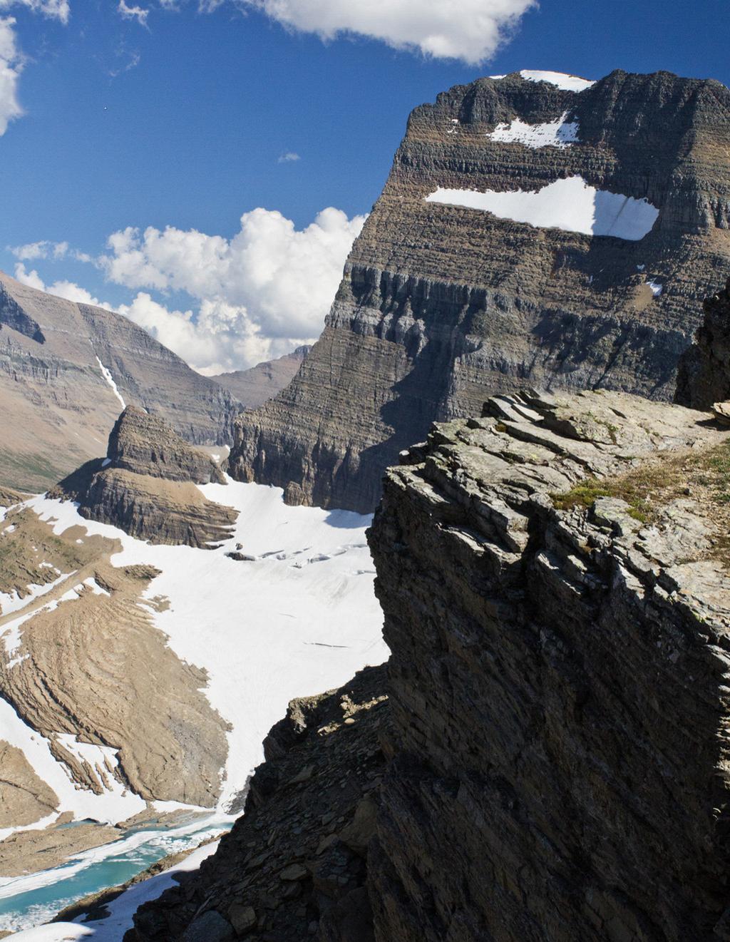
2 Melting Alpine Glaciers in the Rocky Mountains: Impacts on Ecosystems, Agriculture, and Economics by Kevin Moss, State of the Rockies Project Student Researcher Climate change is affecting Western landscapes in many ways, from the subtle to exceedingly obvious. One of the clearest examples is the rapidly shrinking glaciers in Wyoming and Montana. This past year, Rockies Project Student Researcher Kevin Moss investigated how the melting glaciers in the Wind River Range and Glacier National Park are affecting humans, species, and ecosystems. By corroborating scholarly articles with in-person interviews, he came to fully appreciate how crucial glacial meltwater is to the health of ecosystems and society alike. Introduction Global climate change is an international problem with a vast array of effects, such as increasing temperatures, rising sea level, and changing weather patterns (IPCC, 2014). One of the earliest visible aspects of evident global climate change was that of melting glaciers. This is of obvious concern given the implications for sea level rise and reduced global albedo (a measure of the Earth s reflectivity). When most people think of glaciers, they imagine large, continental glaciers, such as those found at the poles. These continental glaciers are a crucial aspect of global climate given their size and reflective capacity. That being said, continental glaciers do not tend to impact people s lives on a day-to-day basis since so few people live near them. Alpine glaciers, on the other hand, are crucial for communities and landscapes across the world (Carey, 2010). Alpine glaciers are much smaller than the continental glaciers that are found at the high latitudes, yet these mountain glaciers are more relevant to most societies since we rely on their meltwaters for drinking water, agriculture, and ecological health. Furthermore, as precipitation patterns change and snowmelt disappears earlier in the year, glaciers become even more crucial as a bank of water for regions that rely on mountain meltwater for drinking and irrigation. In the Himalayas watersheds, billions of people depend on the late summer flows that glaciers provide. Scientists and locals are very concerned about how to manage a diminishing supply of water with a growing population. There is also concern over already obvious ecological changes as regions of the alpine steppe transition to an alpine desert environment (Xu et al., 2009). This extensive study of the Himalayan glaciers by Xu and colleagues (2009) provides valuable insight into the melting glaciers of the Rocky Mountains. Historically, water supply problems determined the fate of societies and civilizations. Seasonal and annual fluctuations in precipitation could force societies to move, or even cause their ultimate demise. However, with dams and irrigation canals, humans have increased their water security and can even live in areas devoid of water (think of Las Vegas, Nevada). Even with this technology, however, changes in water availability still significantly impact societies. Droughts have long ravaged the American West, and melting glaciers represent a new chapter in the history of Western water challenges. The melting glaciers in the Rocky Mountains will by no means doom Western society, but consequences for agriculture, landscapes, and communities may be severe. Glaciers in the Rocky Mountains Though glaciers are still present in the American Rockies, they are disappearing at an alarming rate. Glacier National Park may soon be a misnomer because only 25 glaciers remain of the original 150 that were present in Furthermore, it has been predicted that all the glaciers within the park will disappear by 2030 (Hall and Fagre, 2003). This trend is replicated in the Wind River Range in Wyoming, where 63 of the 80 glaciers in Wyoming are located (Cheesbrough et al., 2009). Between 1985 and 2005, glacier area decreased 25% in the Wind River Range (Cheesbrough et al., 2009). This melting rate is only slated to increase as the planet continues to warm and as the glaciers shrink by reducing the albedo of the landscape and warming the local environment. These two distinct alpine environments, Glacier National Park and the Wind River Range, highlight the severity of the problems associated with melting glaciers in the Rocky Mountain region, but for different reasons. Glacial melt from Glacier National Park is not tied to agriculture in the region, but is vital for supporting ecosystems. The glacial melt plays a crucial function by regulating stream temperatures for alpine macroinvertebrates and migratory trout species, while also providing water for small streams in the late summer (Pederson et al., 2010). Furthermore, the glaciers in Glacier National Park are some of the only easily Kevin Moss is a student researcher for the Rockies Project. Originally from Washington, DC, he is a 2015 Environmental Science Major and Education Minor. His passion for the environment was fostered by spending his summers hiking and canoeing in the Shenandoah Valley. He also recently completed a semester sea kayaking and mountaineering in Patagonia with the National Outdoor Leadership School. Upon graduating, he hopes to pursue outdoor education to help educate the next generation of environmental stewards. In his free time, he enjoys backpacking and playing for Colorado College s Ultimate Frisbee team.
3 accessible and viewable glaciers in the country, thereby serving a key educational and aesthetic role for citizens. They also serve as visual and visceral symbols of climate change in a time when the climate change conversation is seemingly polarized among the American public. On the other hand, glacial melt from the Wind River Range is important for local agriculture and ranching, especially in low snowpack and hotter than average years. The aesthetic beauty of glaciers in Glacier National Park is a key driver for Montana s economy. The Rocky Mountain Climate Organization and the National Resources Defense Council collaborated on a report about the various impacts of climate change in Glacier National Park (Saunders et al., 2010). The report focuses on impacts to species and resources, but also includes a review of the economic importance of Glacier National Park. Two million visitors come to Glacier National Park every year, three quarters of whom are from out of state (Saunders et al., 2010). These visitors contribute $160 million to Glacier National Park per year and support over 4,000 jobs (Saunders et al., 2010). 1 Furthermore, in 2008, out-of-state visitors contributed $3 billion per year to Montana s economy, and 29% of those visitors cited Glacier National Park as their reason for visiting Montana (Saunders et al., 2010). Given that the landscapes of Glacier National Park are rapidly changing with climate change, some are worrying about a drop in tourism due to the potential decrease in aesthetic appeal. A survey conducted in Waterton Lakes National Park, located adjacent to Glacier National Park in Canada, predicts a decrease in tourism due to climate change. In the most severe climate change scenario for Waterton Lakes National Park, highlighted by the loss of all 30 of the glaciers found in the park, 19% of visitors responded that they would not visit the park again and 38% responded that they would visit less often (Saunders et al., 2010). A similar decrease in tourism in Glacier National Park is entirely plausible. Given that Glacier National Park is expected to be devoid of glaciers by 2030, the economic impacts of the melting glaciers could be immediate and immense (Hall and Fagre, 2003). It is clear that a direct study of the economic impacts of the melting glaciers is needed for Glacier National Park. Fortunately, studies of the ecological impacts of the melting glaciers are more prevalent. Endangered Species as Ecological Indicators of a Changing Climate Studies of the melting glaciers in the Rocky Mountains have been common in Glacier National Park, given its pristine nature and the name of the park itself. These various investigations show that many species and the overall functioning of various ecosystems within and around the park are inextricably tied to glacial melt. One of the most extensive projects is related to the native bull trout, Salvelinus confluentus, a threatened species under the Endangered Species Act. Bull trout are found across the Northwest in different river basins, but are struggling due to the effects of invasive species, habitat fragmentation, and climate change. The same is true in the Flathead watershed, which includes flows from the west side of Glacier National 1 This figure is based on a 2002 estimate by the National Park Service, so it could be a substantial underestimate. Park. The bull trout habitat within the park is especially important because approximately one-third of the nation s bull trout populations inhabiting natural, undammed lake systems are found in the park (National Park Service, 2013). Bull trout play a crucial ecological role in the Flathead Watershed by functioning as the top native aquatic predator, so their protection is of the utmost importance. Bull trout in the Flathead Watershed are migratory, meaning that they move to spawn in a stream other than where they normally live. Flathead Lake, the largest freshwater lake west of the Mississippi River in the continental United States, serves as home for many bull trout while many of the alpine streams of Glacier National Park serve as spawning territory. These alpine streams are fed by a combination of snowmelt, glacial melt, and spring water. Bull trout also require a narrow range of temperatures for successful spawning. It has been shown that stream temperatures between 7 and 8 degrees Celsius (44-47 degrees Fahrenheit) are optimal for bull trout habitat (Gamett, 2002). Gamett also found that bull trout densities averaged 15.0 fish/100 m2 at sites where mean temperatures ranged from C while only 1.6 fish/100 m2 were found in sites ranging from C (2002). Furthermore, juvenile bull trout are not able to tolerate higher temperatures as well as adults. Given that the melting glaciers are the only meltwater input regulating stream temperatures in late summer, it is quite foreseeable that these streams will not be suitable spawning habitat for much longer. Given the listing of bull trout as threatened under the Endangered Species Act, their shrinking habitat, and the negative effects of invasive lake trout, the United States Geological Survey has conducted a large amount of research in order to protect the top native aquatic predator. Much of this research has revolved around the invasive lake trout, which were introduced to Flathead Lake in the 1890s. Lake trout, Salvelinus namaycush, a predatory fish that commonly grows up to 40 pounds, feed on many of the same species as bull trout (Guy et al., 2011). This diet overlap leads to an increase in competition between the species and a decrease in the bull trout population (Guy et al., 2011). The lake trout population did not begin increasing until the appearance of Mysis relicta, a non-native shrimp, into Flathead Lake in 1981 (Spencer et al., 1991). Mysis served as a gigantic food source for the lake trout population. Mysis were introduced in an attempt to boost the kokanee population in the Flathead Watershed, but the plan ultimately backfired when they fed heavily on the phytoplankton species that kokanee depended on (Spencer et al., 1991). The kokanee population was eliminated, which reduced competition for young lake trout. Mysis also served as an abundant food source for young lake trout, causing the population to rise dramatically. Since the lake trout population began exploding, the populations of the native assemblages of bull and cutthroat trout have declined. Furthermore, lake trout have started invading the lakes of Glacier National Park. The lake trout invasion into Glacier National Park has resulted in the National Park Service and United States Geological Survey partnering to deliver an in-depth review of the lake trout populations in Glacier National Park. They began the project in 2003 and have found that lake trout inhabit nine
4 of the 12 lakes they can access in the park. Furthermore, a 2007 report categorized 93% of the bull trout population within the park as compromised, with only 6% of the population considered secure (Fredenberg et al., 2007). The Interplay of Glaciers and Ecology As the State of the Rockies team travelled to Glacier National Park, we were able to meet with Carter Fredenberg, biological science technician and one of the lead scientists working on the bull trout issue for the USGS. He is working on a team that has been conducting suppression experiments on lake trout in the Quartz Lake system. Quartz Lake is the largest lake with the native fish assemblage in the park, making it an ideal study site. Fredenberg and his colleague, Joe Giersch, aquatic entomologist for the USGS, discussed some of the challenges with environmental management in the face of climate change. The question of whether to attempt to preserve nature in its found form, or merely protect it as it changes, is a crucial one in the 21st century given how quickly landscapes are being altered. In the case of melting glaciers, there is no direct work that can be done by any individual or local agency to slow the melting Figure 1: Lakes in western Glacier National Park because climate change is a global problem; therefore, management decisions must focus on the effects, not the cause, of the problem. This is where the question of preservation versus protection comes into play. Some conservation groups or agencies attempt to protect landscapes in the face of climate change via adaptive management, an environmental concept that highlights the need to be flexible in environmental management as landscapes change and species migrate. The National Park Service, on the other hand, is chartered with the preservation of landscapes for future generations. This distinction is highlighted in the management plan that has been drafted for the protection of bull trout in Glacier National Park. The action plan splits the 17 lakes on the western slope of Glacier National Park (seen in Figure 1) into three categories: secure, vulnerable, and compromised. Secure lakes refer to those with a bull trout population that is physically separated by a barrier, such as a waterfall, from lake trout populations. These five small backcountry lakes constitute only 6% of the lake surface area in the entire park, but they represent the most pristine bull trout habitat. The action plan states that the priority for secure lakes is the long-term maintenance of current conditions (Fredenberg et al., 2007). Three of these secure British Columbia Alberta Kintla Lake Upper Kintla Lake Akokala Lake Bowman Lake Cerulean Lake Lower Quartz Lake Quartz Lake Middle Quartz Lake Glacier National Park Logging Lake Arrow Lake North Fork Flathead River Rogers Lake Trout Lake Montana Lake McDonald Lincoln Lake Harrison Lake Middle Fork Flathead River Upper Isabel Flathead River Lake Isabel Source: Esri, DigitalGlobe, GeoEye, Earthstar Geographics, CNES/Airbus DS, USDA, USGS, AEX, Getmapping, Aerogrid, IGN, IGP, swisstopo, and the GIS User Community
5 lakes, Upper Kintla, Isabel, and Upper Isabel, are glacial tributaries, thereby making their future existence as habitat for bull trout a bit unclear. Since these lakes are devoid of lake trout and other invasive species, the bull trout in these lakes could function as specific indicator populations of stream temperature increases in the late summer and fall as the glaciers continue to melt. The vulnerable lakes, Akokala and Cerulean, are those that do not contain lake trout but are also devoid of natural barriers to their immigration. The management strategy for these high priority lakes is the active evaluation of methods to maintain or improve the status in these vulnerable bull trout waters (Fredenberg et al., 2007). Compromised lakes are those that already contain lake trout populations. There is great variety in how to manage these lakes given their differences in location and bull trout and lake trout numbers, but suppression of lake trout is ongoing for some of the lakes (Fredenberg et al., 2007). Quartz Lake, the highest priority lake among the compromised ones, has the least impacted bull trout population. Quartz Lake has terrific spawning territory in the stream at the head of the lake and supports a complex assemblage of native fish species. Quartz Lake is connected to Cerulean Lake, Middle Quartz Lake, and Lower Quartz Lake, known collectively as the Quartz Lake drainage. Quartz Lake is located below Cerulean Lake and above Middle and Lower Quartz Lakes. Bull trout move freely along the Quartz Lake drainage, evidenced by the similar genetic profile of the bull trout across the four lakes. This intermixing only makes protecting Quartz Lake even more important because an increase in the population of lake trout in Quartz Lake could have negative effects throughout the drainage. Because the bull trout situation in Glacier National Park is a high priority, there is hope for success. The environmental assessment to continue suppression of lake trout in Quartz Lake states that, results from the recent experimental effort to remove lake trout from Quartz Lake and suppress the population have been promising, which gives hope for the persistence of bull trout in the park (National Park Service, 2013). However, prospects for bull trout outside of the park are not as promising due to the challenges of enforcing stringent population control measures and suppression projects. Furthermore, lake trout have become a popular trophy fish given their large size, which has slowed efforts to diminish the population on Flathead Lake. The ecological impacts of the melting glaciers in Glacier National Park are not solely limited to bull trout. High alpine macroinvertebrates require the cold temperatures that glacial runoff provides. These macroinvertebrates have not been widely studied, but are recognized as a potential indicator species of climate warming in mountain ecosystems (Muhlfeld et al., 2011). Much of the research in Glacier National Park has focused on the meltwater stonefly, Lednia tumana. The meltwater stonefly, endemic to Waterton-Glacier International Peace Park, was petitioned for the Endangered Species Act in The Fish and Wildlife Service determined that the listing of the meltwater stonefly was warranted, but that listing the species is precluded by higher priority actions. The meltwater stonefly is currently still listed as a candidate species under the ESA (Fish and Wildlife Service). Its habitat consists of streams located below glaciers, permanent snowfields, and alpine springs. When discussing the habitat of the meltwater stonefly, Giersch stated that alpine springs offer the ideal combination of stable temperatures and aquatic chemistry. According to Giersch, these alpine springs will be the only available habitat for the meltwater stonefly and other rare alpine invertebrates once the glaciers melt. He stated that the continued existence of the meltwater stonefly and other invertebrates is dependent on what type of stream in which they are currently located. The first macroinvertebrates to disappear will be those living in streams below permanent snowfields because they will not be able to survive as the streams transition from permanent to seasonal flow. The next group to die off will be those living in glacial melt streams because the glaciers will probably last a bit longer than the permanent snowfields. This leaves the alpine springs as the final refuge for alpine macroinvertebrates. Giersch predicts an 80% reduction in habitat for the meltwater stonefly once the glaciers have completely melted. Giersch stressed that the ecosystem role that the meltwater stonefly and other alpine macroinvertebrates play is not very well understood. Craig Thompson (Colorado College 75), professor of engineering and applied science at Western Wyoming Community College, echoed a similar sentiment. He has studied aquatic ecosystems in the glacial meltwaters of the Wind River Range and in Switzerland since Thompson is frustrated by the fact that so little research is being done on these ecosystems and rare macroinvertebrate species in the Rocky Mountains. Since little is known about these species, Giersch and Thompson are both concerned about potential ecological ramifications if they go extinct. Since there is a paucity of research on alpine macroinvertebrates in the Rocky Mountains, looking to other, more researched areas is helpful. A study conducted in the French Pyrenees found that decreased meltwater contributions from glaciers actually increased taxonomic richness and total abundance of stream macroinvertebrates (Brown et al., 2007). In the article they stress the difference between alpha, beta, and gamma diversity. Alpha diversity refers to the species richness in a particular area while beta diversity refers to the species diversity between sites (Whittaker, 1972). Gamma diversity is reflective of the overall diversity of different ecosystems within a region (Whittaker, 1972). In the study area, they found that reduced meltwater contributions increased alpha diversity but decreased beta and gamma diversity. The increase in alpha diversity was due to more species of macroinvertebrates being able to tolerate the warmer streams while the loss of beta and gamma diversity was due to the loss of unique sub-ecosystems and rare, endemic species (Brown et al., 2007). Though the results of this study are interesting and could be indicative of future trends, it is unwise to assume the exact process would be replicated in either Glacier National Park or the Wind River Range. Alpine ecosystems have unique and subtle ecosystem interactions that could impact how the macroinvertebrate community responds to reduced meltwater inputs. Thompson summarizes the problem as follows: 1. We are losing alpine glaciers on every continent. 2. Alpine glacier meltwaters support a vibrant aquatic ecosystem. Since we don t know what role the aquatic insects play
6 Figure 2: Glaciers in the Wind River Range, Wyoming Wind River Wind River Range Riverton! Pinedale! Lander! Glaciers Source: Esri, DigitalGlobe, GeoEye, Earthstar Geographics, CNES/Airbus DS, USDA, USGS, AEX, Getmapping, Aerogrid, IGN, IGP, swisstopo, the GIS User Community, and Glaciers of the American West. in the larger terrestrial ecosystem, we don t know what will happen when they are gone. 3. As alpine glaciers recede, basic ecosystem drivers like temperature, elevation, nutrient input and disturbance will change. Take the glaciers out of the alpine ecosystem and you take away the giant temperature buffer and much more. Who knows what will happen when the glaciers are gone? To better understand how various ecosystems in the Rocky Mountains will respond to melting glaciers and reduced meltwater inputs, Thompson recommends a greater commitment to alpine research and the creation of a regional collaborative of scientists who would conduct research together and discuss findings. Continuous research into the interplay of climate change, melting glaciers, and ecology is needed in the Rocky Mountain region. A better understanding of how the landscape and ecosystems are changing in the 21st century will guide sound policy decisions throughout the future. More research is also needed in regards to how climate change and melting glaciers will impact water availability for agriculture, municipalities, and personal use in the arid West. With shifting precipitation patterns, earlier melting snowpack, and a growing population, water security is of critical importance for society and the environment. Water security in the West is a widely studied and debated issue, with communities, farmers, politicians, environmentalists, and more weighing in. One of the many aspects of the water debate revolves around how to manage water in the late summer months, once seasonal snowmelt has been depleted. In an exception to the rule, communities near the Wind River Range enjoy glacial melt throughout the summer and early fall. But local farmers and ranchers are starting to wonder how much longer the glaciers will last and what will be done once the glaciers are gone. Wind River Glaciers and the Impact on the Agricultural Economy Wyoming has the second-most glaciers of any of the lower 48 states (Washington has more), and 63 of the 80 glaciers in the state are found in the Wind River Range, as seen in Figure 2 (Cheesbrough et al., 2009). These glaciers have not been nearly as widely studied as those in the Glacier National Park, but the scientific community has garnered much useful information about the potential effects of the melting glaciers. There are no concrete predictions for when the glaciers will all disappear, but
7 it has been shown that the glaciers shrunk by an average of 25% between 1985 and 2005 (Cheesbrough et al., 2009). There was also a significant feedback between size and melting rate, for glaciers that were less than 0.5 km2 shrunk by 43% on average while those larger than 0.5 km2 only shrunk by 22% on average (Cheesbrough et al., 2009). This positive feedback is due to the decreased albedo of the landscape around a melting glacier, which causes the immediate area to warm, thereby accelerating the melting of the glacier. The Wind River Range as a whole has also been shown to be warming, for the date of spring snowmelt onset is up to 20 days earlier than it was in the mid-20th century (Hall et al., 2011). This earlier snowmelt only serves to make the glaciers even more crucial as a stable source of water. The importance of the glaciers is not lost on Meredith and Tory Taylor, local farmers in Dubois, Wyoming who own an outfitting company that takes scientists into the Wind River Range to conduct research. They have been living in Dubois for decades and have seen the melting occur first-hand. The Taylors do not think enough people in the community understand the severity of the issue and the need for improvement in water storage methods as late summer flows decrease with the melting glaciers. Between 4 and 10% of warm season (July-October) flows are directly attributable to glacial meltwater (Cheesbrough et al., 2009). This figure was calculated using the stream gages at Dinwoody Creek above Lakes, Bull Lake Creek above Bull Lake, and Green River at Warren Bridge, three locations representing the primary sub-watersheds into which the melting glaciers drain. This 4-10% figure is potentially significantly higher upstream of the gages. This is why the Taylors think that upstream users in the high valleys, such as themselves, are more tuned in to the issue of the melting glaciers. Not surprisingly, they say the biggest impacts of the melting glaciers have been on agriculture and downstream users. Given that Wyoming produces the 8th most barley and 20th most hay in the United States, while also supporting an $800 million cattle industry, the economic impacts of reduced late-season flows could be substantial (Cheesbrough et al., 2009). The Taylors are somewhat frustrated by the lack of response to this issue. They discussed how the conservative political atmosphere of Wyoming is preventing acknowledgement of the problem. They also mentioned that Governor Mead has proposed dam construction projects, but in locations Meredith describes as not ideal. She is also concerned about the significant loss of water due to evaporation that these dams would create. Though the Taylors know that continuing to farm in the area will become more challenging, they are not hopeless. Tory believes that farmers near the headwaters will get by, albeit with lower returns and less year-to-year consistency. He is personally more worried about the broader symptoms of global climate change, such as more frequent hot days and systematic vegetation change in the valley. Fortunately, when I visited during the summer of 2014 the Taylors were enjoying one of the best rain years ever in the valley, on top of what was already a high snowpack year. Tory joked that it was the occasional good year, like 2014, that causes people to forget about the issue of the receding glaciers and slows the conversation about how to deal with the consequences. Next Steps Dealing with diminishing water supplies in the American West will be one of the most challenging environmental issues of our time. Water shortage issues are multifaceted with no easy solutions. A growing population and demand for food are obviously chief factors, but climate change is beginning to have a more obvious impact on the availability of Western water. Sporadic and sparse snowfall has already impacted landscapes and agriculture, and we may soon lose our primary buffer against unpredictable snowfall: glaciers. As nature s water towers, glaciers serve a crucial role by supplementing late-season snowmelt and keeping water levels and temperatures at a relatively normal level. Glaciers and their positive impacts are easy to take for granted, but they will soon be absent from the landscape in the American West. A reduced water supply will not only stress species and ecosystems, but also farming and economics. The issues surrounding melting glaciers in the Rocky Mountains are only going to become more complex and difficult to manage with time. From changing species composition to water security challenges and economic losses, the effects are broad and diverse. The problems will cross federal, state, and private boundaries, raising many difficult management questions along the way. The main way to deal with the increasing impacts of melting glaciers in the Rocky Mountain region is through regional collaborative efforts, much like Craig Thompson recommended. Problems such as reduced irrigation water, altered landscapes, and changing species composition are all landscape-scale problems requiring regional solutions. Without swift and effective action, the impacts of melting glaciers in the Rocky Mountains will be immense, affecting economies, ecosystems, and agriculture.

8 References Brown, L. E., Hannah, D. M., & Milner, A. M Vulnerability of alpine stream biodiversity to shrinking glaciers and snowpacks. Global Change Biology, 13(5), Carey, M In the Shadow of Melting Glaciers. Oxford: Oxford University Press. Cheesbrough, K., Edmunds, J., Tootle, G., Kerr, G., & Pochop, L Estimated wind river range (Wyoming, USA) glacier melt water contributions to agriculture. Remote Sensing, 1(4), Meltwater Lednian Stonefly Designated a Candidate for Endangered Species Protection. United States Fish and Wildlife Service 1 April. Fredenberg, W. Meeuwig, M. Guy, C Action Plan to Conserve Bull Trout in Glacier National Park. United States Fish and Wildlife Service. Gamett, B. L The relationship between water temperature and bull trout distribution and abundance (Doctoral dissertation, Utah State University). Guy, C. S., McMahon, T. E., Fredenberg, W. A., Smith, C. J., Garfield, D. W., & Cox, B. S Diet overlap of top-level predators in recent sympatry: bull trout and nonnative lake trout. Journal of Fish and Wildlife Management, 2(2), Hall, D. K., Foster, J. L., DiGirolamo, N. E., & Riggs, G. A Snow cover, snowmelt timing and stream power in the Wind River Range, Wyoming. Geomorphology, 137(1), Hall, M. H., & Fagre, D. B Modeled climate-induced glacier change in Glacier National Park, BioScience, 53(2), Intergovernmental Panel on Climate Change. Working Group II. Climate Change 2014: Impacts, Adaptation, and Vulnerability Muhlfeld, C. C., Giersch, J. J., Hauer, F. R., Pederson, G. T., Luikart, G., Peterson, D. P., & Fagre, D. B Climate change links fate of glaciers and an endemic alpine invertebrate. Climatic Change, 106(2), Continued Lake Trout Suppression on Quartz Lake & Lake Trout Removal and Bull Trout Conservation in the Logging Lake Drainage- Environmental Assessment. United States Fish and Wildlife Service December. Pederson, G. T., Graumlich, L. J., Fagre, D. B., Kipfer, T., & Muhlfeld, C. C A century of climate and ecosystem change in Western Montana: what do temperature trends portend? Climatic Change, 98(1-2), Saunders, S. Easley, T. Theo. S Glacier National Park in Peril: The Threats of Climate Disruption. The Rocky Mountain Climate Organization and National Resources Defense Council. Spencer, C. N., McClelland, B. R., & Stanford, J. A Shrimp stocking, salmon collapse, and eagle displacement. BioScience, Whittaker, R. H Evolution and measurement of species diversity. Taxon, Xu, J., Grumbine, R. E., Shrestha, A., Eriksson, M., Yang, X., Wang, Y. U. N., & Wilkes, A The melting Himalayas: cascading effects of climate change on water, biodiversity, and livelihoods. Conservation Biology, 23(3),
Regional impacts and vulnerability mountain areas
 Regional impacts and vulnerability mountain areas 1 st EIONET workshop on climate change vulnerability, impacts and adaptation EEA, Copenhagen, 27-28 Nov 2007 Klaus Radunsky 28 Nov 2007 slide 1 Overview
Terrestrial Protected Area Nomination: Central Mangrove Wetland South-West, Grand Cayman
 Terrestrial Protected Area Nomination: Central Mangrove Wetland South-West, Grand Cayman The attached nomination, proposing that a parcel of land in the Central Mangrove Wetland be made a Protected Area
Observation of cryosphere
 Observation of cryosphere By Sagar Ratna Bajracharya (email: sagar.bajracharya@icimod.org) Samjwal Ratna Bajracharya Arun Bhakta Shrestha International Centre for Integrated Mountain Development Kathmandu,
NORTH CASCADE SLACIER CLIMATE PROJECT Director: Dr. Mauri S. Pelto Department of Environmental Science Nichols College, Dudley MA 01571
 NORTH CASCADE SLACIER CLIMATE PROJECT Director: Dr. Mauri S. Pelto Department of Environmental Science Nichols College, Dudley MA 01571 INTRODUCTION The North Cascade Glacier-Climate Project was founded
Yard Creek Provincial Park. Management Plan
 Yard Creek Provincial Park Management Plan Draft January 2010 Yard Creek Provincial Park Management Plan Approved by: telàlsemkin/siyam/chief Scott Benton Bill Williams Squamish Executive Director ation
Michipicoten Island Regional Plan
 Michipicoten Island Regional Plan This is one of twenty Regional Plans that support implementation of the Lake Superior Biodiversity Conservation Strategy (Strategy). The Strategy, prepared and overseen
Saving the Monarch Butterfly
 Saving the Monarch Butterfly Lauren Bennett September 2018 The migration of Monarch Butterflies is so spectacular that it attracts international tourism to regions of the U.S., Canada and Mexico every
The Geological Pacific Northwest. Wednesday February 6, 2012 Pacific Northwest History Mr. Rice
 The Geological Pacific Northwest Wednesday February 6, 2012 Pacific Northwest History Mr. Rice 1 Free Response #2 Please do not simply list the items for this response. Full sentences!!! Minimum of 3-5
Antarctic glaciers' melt is happening more rapidly than was first believed
 Antarctic glaciers' melt is happening more rapidly than was first believed By Los Angeles Times, adapted by Newsela staff on 05.20.14 Word Count 908 This undated handout photo provided by NASA shows the
Antarctic glaciers' melt is happening more rapidly than was first believed
 Antarctic glaciers' melt is happening more rapidly than was first believed By Los Angeles Times, adapted by Newsela staff on 05.20.14 Word Count 908 This undated handout photo provided by NASA shows the
Piedra River Protection Workgroup Meeting #5 Feb. 21, 2012 Ross Aragon Community Center, Pagosa Springs
 Piedra River Protection Workgroup Meeting #5 Feb. 21, 2012 Ross Aragon Community Center, Pagosa Springs What happened at this meeting? - Identified conservation easements - Discussed In-stream Flows -
DIDYMO SURVEY, LOWER FRYINGPAN RIVER, BASALT, COLORADO 2015
 DIDYMO SURVEY, LOWER FRYINGPAN RIVER, BASALT, COLORADO 2015 Second Annual Report PREPARED FOR: ROARING FORK CONSERVANCY PREPARED BY: COLORADO MOUNTAIN COLLEGE NATURAL RESOURCE MANAGEMENT PROGRAM TIMBERLINE
The Conservation Contributions of Ecotourism Cassandra Wardle
 The Conservation Contributions of Ecotourism Cassandra Wardle PhD Candidate, Gold Coast, Australia Supervisors: Ralf Buckley, Aishath Shakeela and Guy Castley State of the Environment State of the Environment
THE DISEQUILBRIUM OF NORTH CASCADE, WASHINGTON GLACIERS
 THE DISEQUILBRIUM OF NORTH CASCADE, WASHINGTON GLACIERS CIRMOUNT 2006, Mount Hood, OR Mauri S. Pelto, North Cascade Glacier Climate Project, Nichols College Dudley, MA 01571 peltoms@nichols.edu NORTH CASCADE
Adaptation in the Everest Region
 Adaptation in the Everest Region Bhawani S. Dongol Program Officer-Freshwater Program WWF- The Global Conservation Organization bhawani.dongol@wwfnepal.org 26 March 2010 Himalayan water towers The Himalayan
Crown of the Continent Ecosystem The Glacier-Great Bear Connectivity Conservation Area Briefing
 Crown of the Continent Ecosystem The Glacier-Great Bear Connectivity Conservation Area Briefing By: Rob Ament & Tyler Creech October 2016 The Glacier-Great Bear Connectivity Conservation Area The Crown
 RAMPART BLVD DURANGO DR RAINBOW BLVD NELLIS BLVD DECATUR BLVD DECATUR BLVD MARYLAND PKWY EASTERN AVE PECOS RD PECOS RD LAMB BLVD LAMB BLVD N RANCHO DR S RANCHO DR INDUSTRIAL RD W SAHARA AVE 1 W CHARLESTON
INTRODUCTION 250,000
 INTRODUCTION The United States of America has over 250,000 rivers, with a total of about 3,500,000 miles of rivers. The main stems of 38 rivers in the United States are at least 500 miles (800 km) long.
The Design of Nature Reserves
 The Design of Nature Reserves Goals Maintenance of MVP s for targeted species Maintenance of intact communities Minimization of disease Considerations of reserve design 1. Disturbance regime Fire Insect
Module 1 Educator s Guide: Representative Discussion Points Investigation 3
 Module 1 Educator s Guide: Representative Discussion Points Investigation 3 Ethiopia and Eritrea Our combined population is 59,578,171 people. We have just emerged from a long period of civil war and famine.
ROCKY MOUNTAIN CLIMATE. A Profile by the Rocky Mountain Climate Organization and the Natural Resources Defense Council. Organization. the.
 A Profile by the Rocky Mountain Climate Organization and the Natural Resources Defense Council About RMCO The Rocky Mountain Climate Organization works to keep the interior American West special by reducing
APPENDIX 'A' Summary of Sage Grouse Petitions Submitted to the U.S. Fish and Wildlife Service (USFWS) 1 (As of January 8, 2004)
 1 (As of January 8, 2004)") APPENDIX 'A' Summary of Sage Grouse Petitions Submitted to the U.S. Fish and Wildlife Service (USFWS) 1 (As of January 8, 2004) Petition Date: May 14, 1999 (74 pages) Species: Washington population of
APPENDIX 'A' Summary of Sage Grouse Petitions Submitted to the U.S. Fish and Wildlife Service (USFWS) 1 (As of January 8, 2004) Petition Date: May 14, 1999 (74 pages) Species: Washington population of
Map 1.1 Wenatchee Watershed Land Ownership
 Map 1.1 Wenatchee Watershed Land Ownership Map 1.1 Wenatchee Watershed Land Ownership The Wenatchee watershed lies in the heart of Washington state in Chelan County. Just larger than the state of Rhode
Pembina Valley Provincial Park. Draft Management Plan
 Pembina Valley Provincial Park Draft Management Plan 2 Pembina Valley Provincial Park Table of Contents 1. Introduction... 3 2. Park History... 3 3. Park Attributes... 3 3.1 Natural... 3 3.2 Recreational...
Attachment B: Treatment Area Maps
 Attachment B: Treatment Area Maps BEACH BOAT RENTAL LAUNCH NO.1 LAUNCH NO. 2 LAUNCH NO. 3 LAUNCH NO. 4 CHANNEL BOG Black Moshannon Lake 0 0.125 0.25 0.5 Source: Esri, DigitalGlobe, GeoEye, Earthstar Geographics,
GRANDE News Letter Volume1, No.3, December 2012
 GRANDE News Letter Volume1, No.3, December 2012 Building a water management system in La Paz, Bolivia Climate change is a phenomenon that affects the entire world, but its impact on people differs depending
Land Use. Grasslands and Rangelands National Parks and Reserves. Thursday, October 9, 14
 Land Use Grasslands and Rangelands National Parks and Reserves MANAGING AND SUSTAINING GRASSLANDS Almost half of the world s livestock graze on natural grasslands (rangelands) and managed grasslands (pastures).
DRAFT TEN August 23 rd, Climate Change Impacts On The Alpine: The Future of Our Mountains
 DRAFT TEN August 23 rd, 2006 Climate Change Impacts On The Alpine: The Future of Our Mountains Introduction In imagining the impacts of climate change, think of where the dawn s light first strikes at
Global Warming in New Zealand
 Reading Practice Global Warming in New Zealand For many environmentalists, the world seems to be getting warmer. As the nearest country of South Polar Region, New Zealand has maintained an upward trend
The Portland State University study of shrinking Mt. Adams glaciers a good example of bad science.
 The Portland State University study of shrinking Mt. Adams glaciers a good example of bad science. Don J. Easterbrook, Dept. of Geology, Western Washington University, Bellingham, WA The recent Portland
Lesson 5: Ice in Action
 Everest Education Expedition Curriculum Lesson 5: Ice in Action Created by Montana State University Extended University and Montana NSF EPSCoR http://www.montana.edu/everest Lesson Overview: Explore glaciers
Last Chance Tourism. Risks and opportunities of an emerging market
 Last Chance Tourism Risks and opportunities of an emerging market Jackie Dawson, Postdoctoral Fellow, University of Guelph Co-authors: Harvey Lemelin (Lakehead), Emma Stewart (Lincoln) TTRA Conference,
Keeping Wilderness Wild: Increasing Effectiveness With Limited Resources
 Keeping Wilderness Wild: Increasing Effectiveness With Limited Resources Linda Merigliano Bryan Smith Abstract Wilderness managers are forced to make increasingly difficult decisions about where to focus
June 29 th 2015 SOS LEMURS SPECIAL INITIATIVE
 June 29 th 2015 SOS LEMURS SPECIAL INITIATIVE 1 SUMMARY FOREWORD...3 SOS LEMURS HELP US SAVE MADAGASCAR S ICONS...3 EMERGENCY ACTION PLAN...4 WHY PROTECT LEMURS?... 4 THE IUCN ACTION PLAN!... 5 GENERAL
2.0 PARK VISION AND ROLES
 2.0 PARK VISION AND ROLES 2.1 Significance in the Protected Area System Marble Range and Edge Hills provincial parks protect 6.8% of the Pavillion Ranges Ecosection, which is located in the Southern Interior
ALBERTA S GRASSLANDS IN CONTEXT
 ALBERTA S GRASSLANDS IN CONTEXT GLOBAL GRASSLANDS 1 Temperate grasslands, located north of the Tropic of Cancer and south of the Tropic of Capricorn, are one of the world s great terrestrial biomes 2.
Title/Name of the area: Chwaka Bay, Zanzibar
 Title/Name of the area: Chwaka Bay, Zanzibar Presented by: Dr. Charles Lugomela, Ag. Head, Department of Aquatic Sciences and Fisheries, University of Dar es Salaam, P.O. Box 35064 Dar es Salaam, Tanzania
Twelve Apostles Marine National Park Australia
 EVALUATION REPORT Twelve Apostles Marine National Park Australia Location: Victoria, Australia coastal waters Global Ocean Refuge Status: Nominated (2017), Evaluated (2017) MPAtlas.org ID: 7703885 Manager(s):
Mark West Creek Flow Study Report
 Mark West Creek Flow Study Report Biology and Geology of Mark West Creek The headwaters of Mark West Creek are located in the Mayacamas Mountain range, which border Napa and Sonoma County, where it then
Case Study: Conserving Ecological Processes in the Eastern Himalayas
 Standard 7: Select terrestrial, freshwater and marine conservation biodiversity elements (a.k.a conservation targets) across multiple biological scales to comprehensively represent the biodiversity of
MAURI PELTO, Nichols College, Dudley, MA
 MAURI PELTO, Nichols College, Dudley, MA 01571(mspelto@nichols.edu) Advice I am looking for Better schemes for utilizing atmospheric circulation indices to provide a better forecast for glacier mass balance?
Mapping the Snout. Subjects. Skills. Materials
 Subjects Mapping the Snout science math physical education Skills measuring cooperative action inferring map reading data interpretation questioning Materials - rulers - Mapping the Snout outline map and
Bear Creek Habitat Improvement Project
 06/10/10 Bear Creek Habitat Improvement Project El Paso County, Colorado Pike National Forest and Colorado Springs Utilities Owned Land Report prepared by: Eric Billmeyer Executive Director Rocky Mountain
Himalayan Glaciers Climate Change, Water Resources, and Water Security. Henry Vaux, Committee Chair December 10, 2012
 Himalayan Glaciers Climate Change, Water Resources, and Water Security Henry Vaux, Committee Chair December 10, 2012 Study Context Glacial meltwater is commonly thought h to significantly ifi contribute
SECTION 3 GENERAL DESCRIPTION OF THE RIVER BASIN
 SECTION 3 GENERAL DESCRIPTION OF THE RIVER BASIN SECTION 3 GENERAL DESCRIPTION OF THE RIVER BASIN River basin description. A general description of the river basin or subbasin, as appropriate, in which
Geoscape Toronto The Oak Ridges Moraine Activity 2 - Page 1 of 10 Information Bulletin
 About 13,000 years ago as the Laurentide Ice Sheet melted, glacial meltwater accumulated between the ice sheet and the Niagara Escarpment. This formed a lake basin into which gravel and sand were deposited.
Federal Outdoor Recreation Trends Effects on Economic Opportunities
 United States Department of Agriculture Federal Outdoor Recreation Trends Effects on Economic Opportunities The Forest Service National Center for Natural Resources Economic Research is assisting the Federal
FINGER-TATUK PROVINCIAL PARK
 FINGER-TATUK PROVINCIAL PARK PURPOSE STATEMENT AND ZONING PLAN March 2003 FINGER-TATUK PROVINCIAL PARK Purpose Statement and Zoning Plan Finger-Tatuk Provincial Park is 17,151 ha in size. It includes the
Public Lands in Alaska. 200 million acres of federal land - Over 57 Million acres of Wilderness more than half the Wilderness in the entire nation
 Public Lands in Alaska 200 million acres of federal land - Over 57 Million acres of Wilderness more than half the Wilderness in the entire nation alaskawild.org Ground Zero for Climate Change Over the
Clearwater Lake Provincial Park. Draft Management Plan
 Clearwater Lake Provincial Park Draft Management Plan Clearwater Lake Provincial Park Draft Management Plan Table of Contents 1. Introduction... 3 2. Park History... 4 3. Park Attributes... 4 3.1 Location/Access...4
Chapter 7 Snow and ice
 Chapter 7 Snow and ice Throughout the solar system there are different types of large ice bodies, not only water ice but also ice made up of ammonia, carbon dioxide and other substances that are gases
Fifty-Year Record of Glacier Change Reveals Shifting Climate in the Pacific Northwest and Alaska, USA
 Fact Sheet 2009 3046 >> Pubs Warehouse > FS 2009 3046 USGS Home Contact USGS Search USGS Fifty-Year Record of Glacier Change Reveals Shifting Climate in the Pacific Northwest and Alaska, USA Fifty years
ECOREGIONAL ASSESSMENT EQUATORIAL PACIFIC EXECUTIVE SUMMARY
 ECOREGIONAL ASSESSMENT EQUATORIAL PACIFIC The Nature Conservancy, Fundación Agua, EcoCiencia, Fundación Jatun Sacha, CDC Ecuador, CDC UNALM 2004. Portafolio de Sitios Prioritarios para la Conservación
Colorado s Instream Flow Program at 40. Celebrating 40 Years of Success and Challenges January 15, 2014 Denver, Colorado
 Colorado s Instream Flow Program at 40 Celebrating 40 Years of Success and Challenges January 15, 2014 Denver, Colorado ISF Program established in 1973 by Senate Bill 97 Recognized the need to correlate
COUNTRY CASE STUDIES: OVERVIEW
 APPENDIX C: COUNTRY CASE STUDIES: OVERVIEW The countries selected as cases for this evaluation include some of the Bank Group s oldest (Brazil and India) and largest clients in terms of both territory
Chapter 2: El Dorado County Characteristics and Demographics
 Chapter 2: El Dorado County Characteristics and Demographics 2.1 Geographic Area and Demographics El Dorado County comprises 1,805 square miles with over half of the area in the Eldorado National Forest
A428 Cambourne to Cambridge Better Bus Journeys. Landscape & Planning Appraisal Study Area. Key. Study Area. Westwick. Oakington.
 Westwick Boxworth Lower Gate Caldecote Highfields Cambridge Crow End Croft Newtown Roman Hill Harlton Source: Esri, DigitalGlobe, GeoEye, Earthstar Haslingfield Geographics, CNES/Airbus DS, USDA, USGS,
April 10, Mark Stiles San Juan Public Lands Center Manager 15 Burnett Court Durango, CO Dear Mark,
 Mark Stiles San Juan Public Lands Center Manager 15 Burnett Court Durango, CO 81301 Dear Mark, We are pleased to offer the following comments on the draft San Juan Public Lands Center management plans
APPENDIX. Alberta Land Stewardship Act AMENDMENTS TO THE SOUTH SASKATCHEWAN REGIONAL PLAN
 APPENDIX Alberta Land Stewardship Act AMENDMENTS TO THE SOUTH SASKATCHEWAN REGIONAL PLAN 1 All references to Alberta Environment and Sustainable Resource Development, Environment and Sustainable Resource
Glaciers. Reading Practice
 Reading Practice A Glaciers Besides the earth s oceans, glacier ice is the largest source of water on earth. A glacier is a massive stream or sheet of ice that moves underneath itself under the influence
Mackinnon Esker Ecological Reserve Draft - Management Plan
 Mackinnon Esker Ecological Reserve Draft - Management Plan May 2011 Photo Credit: This document replaces the direction provided in the Carp Lake Provincial Park and Protected Area and Mackinnon Esker Ecological
Thank you for this second opportunity to comment on the proposed revisions to the Coconino National Forest Management plan.
 March 8, 2011 Flagstaff Biking Organization PO Box 23851 Flagstaff, AZ 86002 Yewah Lau Coconino National Forest Attn: Plan Revision 1824 South Thompson Street Flagstaff, Arizona 86001 Sent via electronic
An experimental habitat enhancement effort for a sandy river: San Rafael River restoration project
 An experimental habitat enhancement effort for a sandy river: San Rafael River restoration project Samuel Lyster Department of Watershed Sciences, Utah State University Brian G. Laub Department of Watershed
Marchand Provincial Park. Management Plan
 Marchand Provincial Park Management Plan 2 Marchand Provincial Park Table of Contents 1. Introduction... 3 2. Park History... 3 3. Park Attributes... 4 3.1 Natural... 4 3.2 Recreational... 4 3.3 Additional
Finn Creek Park. Management Direction Statement Amendment
 Finn Creek Park Management Direction Statement Amendment November 2013 Management Direction Statement Amendment Approved by: Jeff Leahy Regional Director, Thompson Cariboo BC Parks November 12, 2013 Date
Backgrounder Plains Bison Reintroduction to Banff National Park
 Backgrounder Plains Bison Reintroduction to Banff National Park Introduction The five-year reintroduction project is a small- scale initiative that would inform future decisions regarding the feasibility
National Park Service Wilderness Action Plan
 National Park Service U.S. Department of the Interior National Park Service Wilderness Action Plan National Wilderness Steering Committee National Park Service "The mountains can be reached in all seasons.
Whitefish Range Partnership Tentatively Approved by WRP 11/18/2013!Rec. Wilderness Page 1
 Whitefish Range Partnership Tentatively Approved by WRP 11/18/2013!Rec. Wilderness Page 1 Recommended Wilderness Background The Whitefish Range has a long management and legislative history associated
Colorado Life Zone Scavenger Hunt
 Colorado Life Zone Scavenger Hunt Below are worksheets created for all the habitats or life zones. They were designed with the intention of breaking the class up into small groups, and having students
PROUDLY BRINGING YOU CANADA AT ITS BEST. Management Planning Program NEWSLETTER #1 OCTOBER, 2000
 PROUDLY BRINGING YOU CANADA AT ITS BEST VUNTUT NATIONAL PARK Management Planning Program NEWSLETTER #1 OCTOBER, 2000 INTRODUCTION This newsletter launches the development of the first management plan for
TEACHER PAGE Trial Version
 TEACHER PAGE Trial Version * After completion of the lesson, please take a moment to fill out the feedback form on our web site (https://www.cresis.ku.edu/education/k-12/online-data-portal)* Lesson Title:
Water quality management in the Lake Baikal region of Russia
 Lomonosov Moscow State University Faculty of Geography Department of Environmental Management Water quality management in the Lake Baikal region of Russia Dr., Prof. Sergey Kirillov Dr., Prof. Mikhail
Typical avalanche problems
 Typical avalanche problems The European Avalanche Warning Services (EAWS) describes five typical avalanche problems or situations as they occur in avalanche terrain. The Utah Avalanche Center (UAC) has
ECORREGIONAL ASSESSMENT: EASTERN CORDILLERA REAL ORIENTAL PARAMOS AND MONTANE FORESTS
 ECORREGIONAL ASSESSMENT: EASTERN CORDILLERA REAL ORIENTAL PARAMOS AND MONTANE FORESTS The Nature Conservancy, EcoCiencia y Fundación AGUA. 2005. Evaluación Ecorregional de los Páramos y Bosques Montanos
Priority Species, Communities, Ecosystems, and Threats
 Priority Species, Communities, Ecosystems, and Threats East Gippsland Regional Catchment Strategy 2015/2016 1.0 Objective This document aims to assist in the preparation of project applications for 2015-2016
APPENDIX E GLACIERS AND POLAR ICE CAPS
 APPENDIX E GLACIERS AND POLAR ICE CAPS GLACIERS The dictionary defines a glacier as a large mass of ice and snow that forms in areas where the rate of snowfall constantly exceeds the rate at which the
Numaykoos Lake Provincial Park. Management Plan
 Numaykoos Lake Provincial Park Management Plan 2 Numaykoos Lake Provincial Park Table of Contents 1. Introduction... 3 2. Background... 3 3. Park Purpose... 5 4. Park Management Guidelines... 6 Appendix...
Aquatic insect surveys at Mount Magazine State Park and Hobbs State Park Conservation Area with implementation of an educational component
 Aquatic insect surveys at Mount Magazine State Park and Hobbs State Park Conservation Area with implementation of an educational component Arkansas is home to a relatively large number of endemic invertebrates
$850,000 Awarded to 20 Organizations
 $850,000 Awarded to 20 Organizations The Conservation Alliance is pleased to fund the following organizations to support their efforts to protect wild lands and waterways for their habitat and recreation
Section 2 North Slope Ecoregions and Climate Scenarios
 Section 2 North Slope Ecoregions and Climate Scenarios North Slope Ecoregions The geographic/ecological scope of the workshop will be freshwater and terrestrial systems of the North Slope of Alaska, with
UNIT 5 AFRICA PHYSICAL GEOGRAPHY SG 1 - PART II
 UNIT 5 AFRICA PHYSICAL GEOGRAPHY SG 1 - PART II III. CLIMATE & VEGETATION A. The four main climate zones are tropical wet, tropical wet/dry (split into monsoon & savanna), semiarid, and arid. Other climate
TAYLOR CANYON RANCH COLORADO - ROUTT COUNTY - STEAMBOAT SPRINGS
 TAYLOR CANYON RANCH COLORADO - ROUTT COUNTY - STEAMBOAT SPRINGS Tucked up against the steep valley shaped by Mt. Pau and rising to the Routt National Forest, Taylor Canyon Ranch is an easily accessible,
The promotion of tourism in Wales
 The promotion of tourism in Wales AN OUTLINE OF THE POTENTIAL ADVANTAGES AND DISADVANTAGES OF ADVANCING CLOCKS BY AN ADDITIONAL HOUR IN SUMMER AND WINTER Dr. Mayer Hillman Senior Fellow Emeritus, Policy
White Mountain National Forest
 White Mountain National Forest United States Department of Agriculture Forest Service Eastern Region Boles Brook Snowmobile Bridge Decision Memo Boles Brook Snowmobile Bridge Project Town of Woodstock
Glacier change in the American West. The Mazama legacy of f glacier measurements
 Glacier change in the American West 1946 The Mazama legacy of f glacier measurements The relevance of Glaciers Hazards: Debris Flows Outburst Floods Vatnajokull, 1996 White River Glacier, Mt. Hood The
Draft Resolution on wetlands in polar and subpolar regions
 RAMSAR CONVENTION ON WETLANDS 54th Meeting of the Standing Committee Gland, Switzerland, 23 27 April 2018 Submitted by Sweden Draft Resolution on wetlands in polar and subpolar regions SC54-Com.15 (21.14)
BIG ANIMALS and SMALL PARKS: Implications of Wildlife Distribution and Movements for Expansion of Nahanni National Park Reserve. John L.
 BIG ANIMALS and SMALL PARKS: Implications of Wildlife Distribution and Movements for Expansion of Nahanni National Park Reserve John L. Weaver Conservation Report No.1 July 2006 4 SUMMARY The boundaries
MANAGEMENT DIRECTION STATEMENT
 Lower Mainland District MAAGEMET DIRECTIO STATEMET January 2001 for Liumchen Ecological Reserve Ministry of Environment Lands and Parks BC Parks Division Table of Contents Page Introduction... 1 Purpose
MANAGING FRESHWATER INFLOWS TO ESTUARIES
 MANAGING FRESHWATER INFLOWS TO ESTUARIES Yuna River Hydrologic Characterization A. Warner Warner, A. (2005). Yuna River Hydrologic Characterization. University Park, Pennsylvania: The Nature Conservancy.
Observing Subtleties: Traditional Knowledge and Optimal Water Management of Lake St. Martin
 Observing Subtleties: Traditional Knowledge and Optimal Water Management of Lake St. Martin Myrle Traverse and Richard Baydack Abstract Lake St. Martin First Nation is an Anishinaabe community situated
The Economics of Ecosystems and Biodiversity on Bonaire. Tourism value of ecosystems in Bonaire
 The Economics of Ecosystems and Biodiversity on Bonaire Tourism value of ecosystems in Bonaire 2 The Economics of Ecosystems and Biodiversity on Bonaire Tourism value of ecosystems in Bonaire This study
Biodiversity is life Biodiversity is our life
 Biodiversity is life Biodiversity is our life Chapter 10 Section 2 Biodiversity at Risk Objectives Define and give examples of endangered and threatened species. Describe several ways that species are
Draft Resolution on wetlands in polar and subpolar regions
 RAMSAR CONVENTION ON WETLANDS 54th Meeting of the Standing Committee Gland, Switzerland, 23 27 April 2018 Submitted by Sweden Draft Resolution on wetlands in polar and subpolar regions Doc. SC54-21.14
THE REGION LAKE SUPERIOR THE GITCHI-GAMI TRAIL & THE NORTH SHORE
 LAKE SUPERIOR THE GITCHI-GAMI TRAIL & THE NORTH SHORE 7 LAKE SUPERIOR: Water covers 70% of the earth s surface area, but only 3% of it is freshwater. Saltwater makes up 97% of the earth s water supply.
BROUGHTON ARCHIPELAGO PROVINCIAL PARK
 BROUGHTON ARCHIPELAGO PROVINCIAL PARK PURPOSE STATEMENT AND ZONING PLAN March 2003 BROUGHTON ARCHIPELAGO PROVINCIAL PARK Purpose Statement and Zoning Plan Primary Role The primary role is to contribute
Queensland State Election Priorities 2017
 Queensland State Election Priorities 2017 Protecting, conserving and celebrating Queensland s environmental, built and cultural heritage. QUEENSLAND S HERITAGE MAKES A DIFFERENCE Environmental, built and
Water in the Amazon. By Heather and Georgie
 Water in the Amazon By Heather and Georgie The Amazon is the world s largest tropical rainforest. The Amazon is so big that the U.K and Ireland would fit into it 17 times. The Amazon River It s length
Bridge River Delta Park. Management Plan. Final Public Review Draft
 Bridge River Delta Park Management Plan Final Public Review Draft March 2016 Bridge River Delta Park Management Plan Approved by: Jeff Leahy Regional Director Thompson Cariboo Region BC Parks Date Brian
Grade 10 Unit 2 EA 2 Creating an Argument Score: Exemplary
 Grade 10 Unit 2 EA 2 Creating an Argument Score: Exemplary Cute, cuddly, and bearlike, koalas are a beloved animal around the world and in their native home of Australia. Sleeping for 18 hours each day,
The Vjosa River in Albania
 The Vjosa River in Albania Europe s Wild jewel - beautiful, unknown and threatened The extensive braided river section near Tepelena would drown in a reservoir of the future Kalivaç dam. (Romy Durst) Major