THE CANAL BASIN DISTRICT PLAN
|
|
|
- Reynold Houston
- 6 years ago
- Views:
Transcription

1 T h e C a n a l B a s i n D i s t r i c t P l a n, C l e v e l a n d, O h i o F i n a l R e p o r t The Canal Basin District Plan creates a new green infrastructure for the city of Cleveland, introducing a new level of walkability to the community as well as providing safe, nonmotorized access to Lake Erie, Cleveland s neighborhoods and the city s unique amenities. THE CANAL BASIN DISTRICT PLAN
2
3 INTRODUCTION The Canal Basin District is Cleveland s historic convergence of commerce, culture and ecology a place where a regional/national transportation system, a mighty river, and major urban development and industry unite just off the Lake Erie shore. The Canal Basin District Plan is an opportunity to leverage this historic confluence and the many influential initiatives in and adjacent to the study area that are vital to Cleveland s economic, recreational and cultural heritage, and knit them into a single, compelling vision to guide future decision making. The 101-mile Ohio & Erie Canalway America s Byway s Towpath Trail celebrates its journey s end at Canal Basin Park, a proposed 21-acre gateway and interpretive park at the heart of the Canal Basin District. From this heart will radiate a series of thematic trail loops linking Canal Basin Park with destinations of interest, including: The lakefront trail and greenway system outlined in the Cleveland Waterfront District Plan, including Wendy and Edgewater Parks. Adjacent historic gateway neighborhoods, including Historic Gateway, Warehouse District, Ohio City, Downtown Cleveland, Detroit-Shoreway, Tremont and the proposed Harborfront District. Other top attractions such as the Gateway, Public Square, Euclid corridor, West Side Market, Nautica Complex, Cleveland Browns Stadium, Cleveland Convention Center, Edgewater Park (three million visitors per year) and the cultural institutions at North Coast Harbor. Designers of the Towpath Trail recognized that multi-community trails must have a unified identity in terms of materials, width and other technical standards while reflecting local aesthetic diversity. The Canal Basin District Plan builds upon this approach by implementing a trail hierarchy with the Towpath Trail as the primary trail, and a network of secondary and tertiary feeders that complement the Towpath Trail while allowing customized standards to reflect local environs. This includes off-street trails, riverwalks, bridges, specialty nodes and overlooks, and dedicated on-street trails where necessitated by existing conditions. The plan maps a number of trail connections for cyclists and pedestrians that will establish a new green infrastructure in this predominantly urban area. The connections can be completed as funding allows; there is no need to build the entire trail system as one project because there is value in every trail connection. This allows for flexibility with plan implementation. The plan introduces a new level of walkability to the community and provides safe transportation to the array of destinations in and adjacent to the Canal Basin District. The plan also considers planned or potential land use scenarios and illustrates multi-modal connections to public transportation, the Ohio & Erie Canalway America s Byway, the proposed Cuyahoga Valley Scenic Railroad and other attractions. Finally, the plan outlines potential costs, funding and phasing considerations to guide the plan into implementation. The development of the Canal Basin District Plan was based on a community and stakeholder engagement process to ensure that the plan reflects the community s expectations and desires, and that the proposed enhancements will be embraced by those who will use them. Project sponsors included the Downtown Cleveland Alliance and the Ohio Canal Corridor, in partnership with the City of Cleveland. Project funding was provided by the Transportation for Livable Communities Initiative (TLCI) grant from the Northeast Ohio Areawide Coordinating Agency (NOACA), with local matching funding from the project sponsors. page i The Canal Basin District Plan, Cleveland, Ohio Final Report
4
5 Table of Contents Background and Project Area 1-4 Plan Development and Community Engagement 5-8 Project Vision and Guiding Principles 9-10 Design Concepts Trail Concept Development and Evaluation 15 The Plan Purpose of the Plan Appendix A: Technical Advisory Committee Appendix B: TAC and Public Meeting Minutes Appendix C: Comments, Feedback and Related Materials Appendix D: Feasible Alternatives Analysis Matrix List of Figures Figure 1: Existing Conditions 3 Figure 2: Study Area 4 Figure 3: Planning Process Diagram 8 Figure 4: Trail Components 13 Figure 5: Canal Basin District Plan 19 Figure 6: Feasible Alternates Canal Basin District Sub-Area 20 Figure 7: Feasible Alternates Downtown/Neighborhood Sub-Area 25 Figure 8: Feasible Alternates Lakefront Sub-Area 31 Figure 9: Framework Plan 35 Figure 10: View 1 - Lakefront Connector: Edgewater/Wendy Park 36 Figure 11: View 2 - Abandoned Rail Corridor 37 Figure 12: View 3 - Scranton Peninsula 38 Figure 13: View 4 - Riverwalk at Tower City 39 Figure 14: View 5 - Bike Lane on Frankfort Avenue 40 Figure 15: Public Meeting Planning Graphics Appendix B Figure 16: Public Meeting Compilation Plan Appendix B Figure 17: Technical Advisory Meeting Planning Graphics Appendix B Figure 18: Technical Advisory Meeting Compilation Plan Appendix B page iii The Canal Basin District Plan, Cleveland, Ohio Final Report
6
7 BACKGROUND AND PROJECT AREA Canal Basin Park, located at the northern terminus of both the Towpath Trail and the Ohio & Erie Canalway America s Byway, is recognized as the major gateway park for the federally-designated Ohio & Erie Canalway American s Byway in the 2000 Corridor Management Plan. The park will provide a mix of interpretation, information and orientation to the extended (110-mile) linear heritage greenway that stretches from Cleveland s lakefront to New Philadelphia, Ohio. The park is located in the Cuyahoga River Valley, surrounded by dense, urban neighborhoods and downtown Cleveland. Canal Basin Park and the Towpath Trail promise to be important amenities for visitors and Cleveland residents. To fulfill this promise, safe and attractive pedestrian and bicycle connections must be provided from surrounding neighborhoods into downtown Cleveland and the lakefront. The Towpath Trail will redefine the northern Cuyahoga River Valley area through the establishment of an intricate waterfront access system. Additionally, the trail will integrate connections to the public transportation system to broaden the availability of this unique parkway experience to all Clevelanders. The existing character of the Canal Basin District is shown on Figure 1. page 1 The Canal Basin District Plan, Cleveland, Ohio Final Report


8 The Canal Basin District Plan defines a district that includes Canal Basin Park, delineating a number of pedestrian/bicycle/ trail connections to nearby neighborhoods, resulting in a new green infrastructure. The plan introduces a new level of walkability to the community and provides safe transportation access to Lake Erie and Cleveland s amenities. The plan illustrates open space and greenway preservation opportunities within the northern end of the Cuyahoga River Valley, including connections and access to lakefront parks. The plan considers planned and potential changes to adjacent land use scenarios and illustrates multi-modal connections to public transportation, the established Ohio & Erie Canalway America s Byway, the proposed Cuyahoga Valley Scenic Railroad and other destinations of interest. Furthermore, the plan provides a road map for the future actions necessary to take the concept forward into implementation. The Canal Basin District Plan was developed within the framework of a community engagement process that ensured that the recommended multi-use trail connections will in fact reflect connections that will be of value, joining Canal Basin Park to destinations of interest. This project is sponsored by the Downtown Cleveland Alliance and the Ohio Canal Corridor, in partnership with the City of Cleveland. Project funding was provided by the Transportation for Livable Communities Initiative (TLCI) grant from the Northeast Ohio Areawide Coordinating Agency (NOACA), with local matching funding from the project sponsors. The Canal Basin District Plan, Cleveland, Ohio Final Report page 2 Columbus Road Lift Bridge Project Area Nautica Complex (at left) The planned 21-acre Canal Basin Park is located on the east bank of the Cuyahoga River less than 1 mile upstream from its confluence with Lake Erie. The area incorporated into the Canal Basin District Plan extends well beyond the boundaries of the park itself, into downtown, the surrounding community and the lakefront. The future park has not yet been designed, and its design is not part of this project. Rather, this plan identifies potential connections between the park and desired destinations surrounding the park. The study area is illustrated in Figure 2. The route of the Towpath Trail as depicted is a product of numerous previous planning efforts, beginning with the Cuyahoga County Planning Commission s North Cuyahoga Valley Corridor Concept Plan (1992), the National Park Service s The Ohio and Erie Canal Corridor Study: A Route to Prosperity (1993), the Ohio & Erie Canal Association s Corridor Management Plan (2000) and two follow-up studies concentrating on the route of the Towpath Trail in Cuyahoga County.
9 PLAN DEVELOPMENT AND COMMUNITY ENGAGEMENT Development of the Canal Basin District Plan was based on a community engagement process that consisted of a series of meetings with the Steering Committee, the Technical Advisory Committee (TAC) and the general public. In addition, a series of one-on-one meetings were held with a targeted group of business owners, land owners, government agencies, local non-profit groups and special interest organizations. These meetings were avenues to the generation and presentation of ideas, concepts and priorities, where feedback was obtained that was then incorporated into the plan. The Steering Committee consisted of the three project sponsors the Downtown Cleveland Alliance, Ohio Canal Corridor and the City of Cleveland who worked with the project consultant team (JJR, LLC and Michael Baker Jr., Inc.) throughout the planning process. The Steering Committee is the decision-making body that guided the plan development process. The TAC was comprised of agencies and organizations with a vested interest in the project and how it will fit into the community. The TAC membership list is provided in Appendix A. The planning process integrated input from the Steering Committee and the TAC along with the public to develop the Canal Basin District Plan. Refer to the Planning Process Diagram, Figure 3. page 5 The Canal Basin District Plan, Cleveland, Ohio Final Report


10 The plan was developed through a series of TAC and public meetings. The meetings produced a number of maps showing desired trail routes and/or connections. Project team meetings were held to refine and evaluate the concepts that were developed at the TAC and public meetings. Minutes from the TAC and public meetings are provided in Appendix B. Comments, feedback and related materials and information that was formally submitted as part of the plan development process is provided in Appendix C. The first TAC and public meetings were held to introduce the project and to generate ideas and concepts for trail connections and destinations. Questionnaires were distributed to document desired connections, priorities and other ideas related to plan development. TAC Meeting #1 July 29, 2008 The project sponsors gave a formal presentation to discuss the development of the plan, ideas for consideration and the planning process, and introduced the project consultant team. The TAC members then divided into three working groups for interactive sessions to brainstorm and develop ideas for the project, focusing on trail connections between Canal Basin Park and potential destinations of interest within the study area as well as routes for those connections. The TAC reconvened, and each group presented and reviewed their ideas for the assembled TAC members. Public Meeting #1 July 29, 2008 The first public meeting followed the same format as the first TAC meeting, with a formal presentation to introduce the project and the project consultant team followed by work sessions to generate ideas and develop concepts. The Canal Basin District Plan, Cleveland, Ohio Final Report page 6 Public Meeting #1 Public Meeting #1


11 The second TAC and public meetings provided information on conceptual alternatives that were developed from the concepts identified in the first set of meetings. Each meeting included a group work session and solicitation of additional feedback. TAC Meeting #2 September 16, 2008 The purpose of the second TAC meeting was to further define the community s expectations and desires for connecting Canal Basin Park to area amenities and destinations. The formal presentation provided concepts that were developed based on input from the first TAC and public meetings. Flats Industry, a local industry and business support organization, presented a video that documented industrial traffic in the Flats, focusing on the truck traffic on the Willow Avenue Vertical Lift Bridge, with an expressed concern regarding adding bicycle and pedestrian traffic to the bridge and the associated safety concerns with the conflicting transit modes. The emphasis was on finding a way to safely provide access to Whiskey Island and Wendy Park that does not negatively impact existing industries and businesses in the area. The formal presentation was followed by a group work session, facilitated by the project consultant team, where concepts for three sub-areas were studied and evaluated with respect to how they meet the project goals, potential conflicts or hurdles, and other related topics of discussion. Public Meeting #2 September 16, 2008 The second public meeting followed the same format as the TAC meeting, with a formal presentation to introduce the project followed by a work session to generate ideas and develop concepts. Public Meeting #3 March 11, 2009 The preferred plan was presented to the public at the third and final public meeting. The meeting was held in an open house format, which allowed the public and interested stakeholders to review the proposed Canal Basin District Plan graphics. The preferred plan and supporting graphics were organized into three major stations. The first station highlighted the initial planning process and associated meetings. The second station outlined the plan alternatives and provided a matrix that was used to characterize the various greenway connections and paths. The third station displayed the preferred plan with supporting graphics to highlight the characteristics of the plan. The project consultant team was available to answer questions and discuss the various components of the plan. Comments on the plan were solicited from the meeting attendees and are included in Appendix C. Public Meeting #3 Public Meeting #3 page 7 The Canal Basin District Plan, Cleveland, Ohio Final Report
12 Existing Conditions Base Map(s) Opportunities Diagram(s) Constraints Diagram(s) Meetings Vision/Purpose and Need Statement Kick-Off Meeting TAC/Public Meeting #1 TAC/Public Meeting #2 TAC/Public Meeting #3 Guiding Principles Framework Plan Lakefront Loop/ Sub-Area Canal Basin District Loop/Sub-Area Downtown Loop/Sub-Area The Canal Basin District Plan, Cleveland, Ohio Final Report page 8 Alternatives Imagery Assessment Figure 3: Planning Process Diagram Alternatives Imagery Assessment Preferred Alternative Alternatives Imagery Assessment
13 PROJECT VISION AND GUIDING PRINCIPLES Project Vision The project vision is to create a series of connections between area amenities and destinations and Canal Basin Park, considering both existing and planned development in the area. This series of connections will be a watershed network of trails that serves the community by providing greenway access to and from the Towpath Trail and Canal Basin Park. The project s guiding principles were developed to support this vision. page 9 The Canal Basin District Plan, Cleveland, Ohio Final Report
14 Purpose and Need Bicycle Connections Satisfy the requirements of recreational users. As a priority, provide off-road trails that exceed minimum width standards to accommodate landscaping, visitor amenities (benches, interpretive signage, etc.) and public art. Bike lanes are a lower priority, followed by shared-use lanes. Pedestrian Connections Provide trail walk widths that exceed minimum standards to accommodate two-way pedestrian traffic, landscaping, visitor amenities (benches, interpretive signage, etc.) and public art. Other Considerations Integrate connections from the trail system to bus and rail transit facilities, including the proposed Cuyahoga Valley Scenic Railroad. Interface the trail system with the Cleveland Bikeway Master Plan. Provide direct trail connections to the Towpath Trail and Canal Basin Park. Optimize the visitor experience on the trail system. Consider constructability, physical constraints and estimated costs during design and implementation of the project. Designate riverwalk areas to provide interface between the trail connections and the river. Guiding Principles The Canal Basin District Plan, Cleveland, Ohio Final Report page 10 Emphasize Canal Basin Park as a primary destination and hub within the downtown Cleveland area. Establish a linkage hierarchy with the Towpath Trail as the primary trail. Integrate and connect surrounding attractions and destinations with Canal Basin Park. Encourage and facilitate local neighborhood links and related regional systems to the primary system. Prioritize the family experience as the primary target bike user when designing the trail system. Emphasize the historic significance of the Ohio Canal, Canal Basin Park and other important features in the area. Establish dedicated off-street bicycle and pedestrian path systems, wherever possible. Establish links to complementary transit modes including the Greater Cleveland Regional Transit Authority (GCRTA) rail and bus transit and the proposed Cuyahoga Valley Scenic Railroad. Separate incompatible transit modes for improved safety and user experience. Integrate a network of support amenities (bike rentals, lockers, bike parking, etc.) to support alternate travel modes in and around the park. Establish the Canal Basin Park system as a model of sustainable design. Base design decisions on an implementation strategy that maximizes flexibility, cost effectiveness and ease of phasing. Project goals were developed as a reflection of the project vision and guiding principles. The goals were used to assess the effectiveness of the proposed connections and to assist in the prioritization of alternatives (refer to Project Goals on page 42).
15 DESIGN CONCEPTS The project vision clearly demonstrates a desire for off-road trails, supplemented with wayfinding signage, amenities, and other features such as riverwalks and interpretive areas. Where off-road trails are not feasible, bike lanes on existing roadways may be provided to accommodate cyclists, and a uniquely identified sidewalk trail may be provided to accommodate pedestrians. The trail system network will be characterized by a wayfinding system that identifies connections as part of the Towpath Trail network. Design of the wayfinding system and specific trail features are not included as part of this study. The design of the path alignments and routing took three major trail components into consideration: bridges/overpasses/underpasses, on- and off-street trail designations, and river s edge greenways. Refer to Figure 4 for the trail components diagrams. These trail components were considered during the evaluation of the feasibility of the various routing options. page 11 The Canal Basin District Plan, Cleveland, Ohio Final Report
16
17 TRAIL CONCEPT DEVELOPMENT AND EVALUATION The primary purpose of Canal Basin District Plan is to develop a network of trails that connects Canal Basin Park with the many and various destinations and attractions in downtown Cleveland and its surrounding neighborhoods. Conceptual trail connections were based on the project vision and guiding principles, with input from the community through the TAC and public meetings. In developing the proposed connections and their specific routes, consideration was given to both existing and proposed developments within and near the study area. The conceptual trail connections were assessed using the alternatives evaluation matrix, shown in Appendix D. The matrix lists all of the alternatives and scores them in areas related to the project goals (refer to Project Goals on page 42). During the alternatives evaluation process, suggested trail connections that duplicated others already planned, such as those shown in the Cleveland Bikeway Master Plan and the West Shoreway project, were eliminated from the Canal Basin District Plan. The resulting plan includes only new connections that will work with other plans and projects to provide a complete and comprehensive greenway network within the study area. All of the potential trail connections that are identified in the plan and are scored on the matrix are viable. The plan provides a menu of choices that can be funded and implemented individually or in groups. page 15 The Canal Basin District Plan, Cleveland, Ohio Final Report
18
19 THE PLAN The Canal Basin District Plan is illustrated in Figure 5. The connections can be implemented as funding allows; there is no need to build the entire trail system as one project, because there is value in every trail connection. The Canal Basin District consists of three sub-areas, or neighborhoods, each with different needs and characteristics. They are: Canal Basin District Sub-Area: Canal Basin Park is at the heart of the Canal Basin District. The centralized location of Canal Basin Park makes it possible for the development of three major loop systems that begin and end at the park. These loop systems will extend into other sub-areas (Downtown/Neighborhood and Lakefront) and within the Canal Basin District Sub-Area. The historical significance of the area, including the Ohio and Erie Canal, the Flats, the ship turning basin and the maritime industry, will be part of the design of the park and will provide interpretive opportunities. In addition, the location and geography of the area, including the adjacent Cuyahoga River, bridges and the variations in topography, will need to be taken into consideration for the design of the park and the associated trail system. Downtown/Neighborhood Sub-Area: Downtown Cleveland is a very walkable area, in spite of the predominant vehicular traffic. There are wide sidewalks, and the street grid provides a network that facilitates travel choices. The trail connections in this area need to integrate well with the existing infrastructure. This is the only part of the plan where bike facilities (bike lanes) are separated from pedestrian facilities (sidewalk trails), due to the nature of the system and the pedestrian volumes on the sidewalks. Lakefront Sub-Area: Lake Erie is a mecca for trail users. It is important that Canal Basin Park is effectively connected to the lake and its potential future development on both sides of the Cuyahoga River. The study area was divided into these three sub-areas during the planning process to better manage the plan s development and to more effectively visualize and provide connectivity for the trail network in each sub-area. The individual trail connections are described below and shown in Figures 6 through 8. page 17 The Canal Basin District Plan, Cleveland, Ohio Final Report
20
21 Canal Basin District Sub-Area A-1 Trail Loop Connection Between Canal Basin Park and the Towpath Primary and Secondary Trails This series of connections will create an off-road loop trail that connects Canal Basin Park with the Towpath Trail s primary and secondary trails in the Flats. A-1a Amenities Along the Loop Trail with Interpretive Signs at Areas of Interest: Irishtown Bend, Hart Crane Park, Green Bulkheads, Settlers Landing, Etc. This alternative enhances the Canal Basin District Sub-Area loop trail (A-1) by providing amenities along the trail (seating/benches, public art, wayfinding signage, etc.). It also provides interpretive elements at specific areas of interest, such as Irishtown Bend, Hart Crane Park, Settlers Landing, potential green bulkhead locations, and so forth. The location, type and design of these amenities will be determined during final design, the next phase of the Canal Basin District Plan project. A-1b Secondary Towpath Trail Link Along the Base of Scranton Peninsula Scranton Road to Columbus Road This new trail connection is an off-road, multi-purpose trail (10 to 12 feet wide) that links the primary Towpath Trail from Scranton Road to Columbus Road. The trail alignment can be along the abandoned railroad corridor that runs along the base (west side) of the Scranton Peninsula, or downhill from the rail corridor. The alignment decision can be based on property availability. This trail connection is kept separate from the continued trail connection along Riverbed Street to the south because it can be completed independently and does not rely on the stabilization of the slope along Riverbed Street. It provides a complete loop through Canal Basin Park via the connection along Columbus Road. The trail will cross an active railroad (grain railroad); therefore, coordination with Norfolk Southern Railroad will be necessary. This connection is identified as a Towpath Trail secondary trail and may be included as part of the Towpath Trail project. The corridor for the Towpath Trail primary trail runs downriver along University Road then turns north along Scranton Road. The Towpath Trail secondary trail diverges from the primary trail at Scranton Road. The secondary trail can cross Scranton Road via an at-grade crossing or a grade-separated crossing. The existing stone abutment on the west side of Scranton Road may be considered for use by the secondary trail. There is no matching structure on the east side of Scranton Road. - A-1b:1 New Bridge (Grade-Separated Trail Crossing) at Scranton Road Provide a grade-separated trail crossing at Scranton Road. A grade-separated crossing will allow proper height clearance of the active railroad along with a raised crossing from Scranton Road. This can be an alternative connection if an at-grade crossing of the railroad is not viable. It may be possible to utilize an existing stone abutment on the west side of Scranton Road for the new bridge. This abutment will have to be studied to determine if it can be used as part of the new bridge. If the existing abutment cannot be used, a new structure will need to be built that either incorporates the existing abutment or replaces/avoids it. There is no matching structure on the east side of Scranton Road. - A-1b:2 At-Grade Trail Crossing at Scranton Road Provide an at-grade trail crossing of Scranton Road near University Road at the divergence of the primary and secondary Towpath Trail sections as the trail heads downriver. The secondary trail follows along the base of the Scranton Peninsula. A-1c Towpath Trail Link Along Irishtown Bend - A-1c:1 Secondary Towpath Trail Link Along the Abandoned Railroad Corridor on the West Side of the Cuyahoga River Columbus Road to Center Street and the Nautica Complex This new trail connection is an off-road, multi-purpose trail (10 to 12 feet wide) that links Columbus Road to Center Street and the Nautica Complex along the abandoned railroad corridor located between Riverbed Street and the Cuyahoga River. There are slope stability issues that must be addressed for this trail connection to be viable. Current estimates to fix the hillside range from $25 to $250 million. This connection may be included as part of the Towpath Trail project. page 21 The Canal Basin District Plan, Cleveland, Ohio Final Report
22 - A-1c:2 Secondary Towpath Trail Link Along the Riverbed Street Alignment on the West Side of the Cuyahoga River Columbus Road to Center Street and the Nautica Complex This new trail connection is an off-road, multi-purpose trail (10 to 12 feet wide) that links Columbus Road to Center Street and the Nautica Complex along the current Riverbed Street alignment that runs along the west bank of the Cuyahoga River. This alignment will replace the Riverbed Street and will only be feasible if Riverbed Street is abandoned after the hillside slope stability problems are resolved. This alignment may not be practical, because use of Riverbed Street by vehicular traffic will likely be part of the justification to incur the substantial costs to fix the hillside. This connection may be included as part of the Towpath Trail project. A-1d:1 Trail Connection Under the GCRTA Red Line Viaduct from Riverbed Street to Canal Basin Park This new trail connection will be an off-road, multi-purpose trail (10-12 wide) that runs from the Columbus Road Lift Bridge and Hart Crane Park, west on Merwin Avenue, then north under the GCRTA Red Line viaduct to Canal Basin Park. The Columbus Road Lift Bridge should have on-street bike lanes in addition to the sidewalk along the bridge deck. The trail will tie into the bridge and can run through Hart Crane Park between Merwin Avenue and the Cuyahoga River. This link provides a connection that creates a loop through Canal Basin Park, should the link along Riverbed Street remain incomplete due to the slope stability problems. This connection along the Columbus Peninsula links the secondary Towpath Trail section along the base of the Scranton Peninsula with Canal Basin Park. A-1d:2 Trail Connection Along Columbus Road from Riverbed Street to Canal Basin Park This new connection will preferably be an off-road, multi-purpose trail (10 to 12 feet wide), with the exception of the Columbus Road Lift Bridge, which should have on-street bike lanes in addition to the sidewalk along the bridge deck. The trail will run along the east side of Columbus Road. If an off-road trail is not feasible, this connection will consist of on-street, dedicated bike lanes (5 feet wide) and a detached sidewalk (5 to 6 feet wide). This link provides a connection that creates a loop through Canal Basin Park, should the link along Riverbed Street remain incomplete due to the slope stability problems. This link along the Columbus Road corridor connects the secondary Towpath Trail section along the base of the Scranton Peninsula with Canal Basin Park. A-1e New Moveable Bike/Pedestrian Bridge Across the Cuyahoga River Near the Center Street Swing Bridge and Nautica Complex A new moveable bridge that connects Canal Basin Park with Center Street and the Nautica Complex will provide access across the Cuyahoga River for non-motorized travelers. This will enhance bike and pedestrian access by providing an alternative to the existing Center Street Swing Bridge, which has sidewalks but is too narrow to accommodate on-street bike lanes. Ongoing bridge operations and maintenance, and funding for bridge construction must be addressed. This bridge will be costly to construct and maintain. This connection may be included as part of the Towpath Trail project. The Canal Basin District Plan, Cleveland, Ohio Final Report page 22 A-2 Trail Connection Along Columbus Road, Linking the GCRTA Station, West Side Market and West Twenty- Fifth Street to Riverbed Street and Canal Basin Park This connection consists of on-street, dedicated bike lanes (5 feet wide) and a detached sidewalk trail (5 to 6 feet wide) that connects the GCRTA station, West Side Market, West Twenty-Fifth Street and other Ohio City destinations with the Towpath Trail and Canal Basin Park. In addition, Abbey Avenue can be used as a bikeway to provide additional access to Tremont. This connection is an extension of the trail system along the Columbus Peninsula between Canal Basin Park and the secondary Towpath Trail on Scranton Peninsula. A-3a Trail Connection Along the East Bank of the Cuyahoga River (Canal Road Corridor) Canal Basin Park to Time Warner Cable Amphitheater at Tower City This trail connection is an off-road, multi-purpose trail (10 to 12 feet wide) along the Cuyahoga River that links Canal Basin Park to the Time Warner Cable Amphitheater at Tower City and the proposed Cuyahoga Valley Scenic Railroad station. The preferred trail location is along the river. Continued coordination is necessary with the adjacent property owners, The Sherwin-Williams Company and Forest City Enterprises.
23 A-3b Riverwalk Along the East Bank of the Cuyahoga River (Canal Road Corridor) Near Tower City Center A riverwalk near Tower City Center will provide a wide, open area for people to congregate and enjoy the outdoor space, as well as travel to and from Canal Basin Park. The riverwalk will enhance the basic trail connection (A-3a) by adding a lively public area along the river, expanding the area s attractions from the nearby Time Warner Cable Amphitheater at Tower City, and providing a potential future connection to the Cuyahoga Valley Scenic Railroad and other points of interest. Continued coordination with the adjacent land owners, The Sherwin-Williams Company and Forest City Enterprises, is necessary. A-4 Transition from River Level to City Level Near the Time Warner Cable Amphitheater at Tower City and the Gateway This connection will enable pedestrians and cyclists to easily travel between the riverfront and the Gateway (Progressive Field, Quicken Loans Arena, etc.). The connection can be a stairway/elevator system that connects to the Eagle Avenue parking structure that spans the GCRTA tracks and connects to Canal Road and points beyond with a multi-purpose trail (10 to 12 feet wide). Rather than an elevator, a less expensive option can be a hook and pulley system devised to lift bicycles while the rider climbs the stairs. Such a system will not provide ADA accessibility unless it can carry pedestrians as well as bicycles. The condition of the Eagle Avenue parking structure must be evaluated to determine the feasibility of the connection at this location. An off-road, multi-purpose trail will connect the structure with the amphitheater. A sidewalk trail will connect the structure with the Eagle Avenue/Ontario Street intersection; this intersection is signalized and operates on flash but can be converted to a pedestrian-activated signal. The structure should be linked to the Towpath Trail network in the Cuyahoga River Valley via extension of the existing sidewalk/trail to the Time Warner Cable Amphitheater at Tower City. The Stones Levee Bridge can be used to provide pedestrian access to the amphitheater and the river level. A-5 Riverwalk Along Future Flats East Bank Development and Lakeshore A riverwalk on the east bank of the Cuyahoga River by its confluence with Lake Erie will provide a wide, open area for people to congregate and enjoy the outdoor space, as well as travel to and from Canal Basin Park. The riverwalk can be incorporated into the design of the proposed Flats East Bank development and can be completed by the developer when that project moves forward, or it can be constructed separately if the Flats East Bank development does not move forward in a timely manner. The riverwalk will add a lively public area along the river, expanding the area s attractions across the river from the Nautica Complex. A portion of the riverwalk is expected to be included as part of the Flats East Bank development, and a portion can be included in the Port of Cleveland s Lakefront Master Plan for the redevelopment of the existing port site. Ongoing coordination with both development entities is necessary. A-6 Riverwalk Along the West Bank of the Cuyahoga River on the East Side of Scranton Peninsula A riverwalk on the west bank of the Cuyahoga River along the Scranton Peninsula will provide additional opportunities for waterfront interactions. The land is currently underutilized and presumably available for future development. Coordination with the property owners will be necessary. This riverwalk area will likely be included as part of the Towpath Trail Stage IV project. A-7 Extension of the Nautica Complex Boardwalk; Create a Riverwalk from Heritage Park to the Old River Channel Extend the existing Nautica Complex boardwalk upriver, past the Plain Dealer Pavilion and the bridge, and connect to Heritage Park. Likewise, extend the boardwalk downriver to the Old River Channel. This connection will allow the trail to remain along the waterfront at a very scenic section of the Cuyahoga River. The location and boundaries of the navigable channel must be considered, and impacts to the navigable channel must be avoided. page 23 The Canal Basin District Plan, Cleveland, Ohio Final Report
24
25 Downtown/Neighborhood Sub-Area B-1a Trail Connection Along the GCRTA Bridge, Between the Lorain-Carnegie Bridge and Canal Basin Park This trail connection will be built on half of the GCRTA bridge. The connection to Canal Basin Park can be made via ramps that will land in the park near the Canal/Center/Carter/Lockwood (4C s) intersection. Viability of this connection depends on GCRTA s full support and other affected property owners. This connection may require relocation or removal of track sections on the existing bridge, and it will require construction of the ramp structure to access the park. The access ramps will need to comply to ADA standards, particularly with respect to slope. B-1b Extension of the GCRTA Bridge Connection from Canal Basin Park to the Federal Courthouse This alternative extends the trail on the GCRTA bridge east to connect to the Federal Courthouse, landing along the stairway at an appropriate location and elevation. Travel by cyclists continuing up or down the hillside can be facilitated with bicycle trenches (or other bicycle assist features) adjacent to the walkway. It will require the construction of a structure to carry the multi-purpose trail. This connection is viable only if the B-1a connection is provided. In addition, viability of this connection depends on full support from GCRTA, the Federal Courthouse and the General Services Administration (GSA). The GSA is the owner of the parking lot located between the Detroit-Superior Bridge and the Federal Courthouse. Development plans for that site show a parking structure. Should a parking structure be built, it will be beneficial to equip it with elevators large enough to transport bicycles; this will facilitate alternate mode access between Canal Basin Park, the Downtown area and the Cleveland Lakefront Bikeway. B-2 Clearly Identified Pedestrian/Trail Network in Downtown Area This alternative is a combination of connections, separately defined and described below. Public Square is the heart of Downtown; there will be a clear trail connection between Canal Basin Park and Public Square with additional trail connections linked to Public Square and other points of interest. The trail should be distinctly identified with a unique surface (not a standard concrete sidewalk) and wayfinding signage. The trail will interface with the identified City of Cleveland Downtown Pedestrian Routes. The guiding principle for the Downtown pedestrian trail network is to provide a clear route to Public Square, which will then provide access to numerous other Downtown destinations. Public Square then becomes an organizing hub for the pedestrian trail network. B-2a Canal Basin Park Connection to Public Square Via a Downtown Pedestrian Trail Provide a trail/sidewalk connection from Canal Basin Park near GCRTA s Settlers Landing Station, up Old Superior Viaduct, along Superior Avenue to Public Square, ending in a loop connection along the Public Square roadway. The trail will be within the existing city sidewalk network, with specific visual features that identify it as the Canal Basin Park/Towpath Trail. Such visual features can be colored concrete or special pavers, wayfinding signage and other easily identifiable amenities. Consider closing the top of Old Superior Viaduct to motorized vehicles while allowing non-motorized transit between the Superior/Huron/West Ninth/Old Superior intersection and the West Tenth/Old Superior intersection. This will improve safety for cyclists and pedestrians, and it will provide more standardized operations at the signalized intersection. The impacts to vehicular traffic must be evaluated prior to implementing closure of this section of Old Superior Viaduct. B-2b Downtown Pedestrian Trail Connection to the Visitor Center in the Higbee Building (Tower City Area, South Public Square) This trail/sidewalk connection is provided via the loop connection along the Public Square roadway. B-2c Downtown Pedestrian Trail Connection to Euclid Corridor and Points Beyond This trail/sidewalk connection is provided via the loop connection along the Public Square roadway. Euclid corridor provides direct access to Playhouse Square and Cleveland State University. B-3 Network of On-Street Bike Lanes in Downtown Area The on-street bike network is predominantly addressed by the City of Cleveland's existing and planned bicycle accommodations, as shown on their Downtown Bicycle Routes map and as indicated in the Cleveland Bikeway Master Plan. The city s system can be supplemented with the connection alternatives described below. Public Square is the heart of Downtown; there will be a clear bike connection between Canal Basin Park and Public Square with additional connections linked to Public Square and other points of interest. page 27 The Canal Basin District Plan, Cleveland, Ohio Final Report
26 B3-a Bike Lane Loop Around Public Square A one-way, counterclockwise bike trail loop around Public Square, congruent with the vehicular travel pattern, will serve as a circulator path that provides bike access to Tower City, the visitor information center in the Higbee Building, the Euclid corridor and the city s on-street bike network. B-3b On-Street Bike Lanes Along the Frankfort-Rockwell Corridor The Frankfort-Rockwell corridor is a one-way, westbound roadway that has fairly low vehicular traffic volumes. The eastbound bike lane will be a contra-flow lane. Provision of bike lanes between West Ninth Street and East Thirteenth Street will likely result in the removal of one parking lane or one travel lane. Connection to the Mall and East Sixth Street is necessary. Extension of the bike lanes to the east is optional and should be coordinated with the City of Cleveland. B-3c Bike/Pedestrian Trail Connections to the Gateway Area - B-3c:1 Bike/Pedestrian Trail Connection to the Bike Station (Gateway Area) Via East Fourth Street Provide a connection between Euclid Avenue and the bike station via East Fourth Street. Vehicular traffic is prohibited for part of the East Fourth Street corridor; care must be taken to minimize potential conflicts between cyclists and pedestrians. It may make sense to provide a secondary link to the bike station, with the primary link following the existing pedestrian path that runs between Prospect Avenue and the Gateway to the east of East Fourth Street, then along East Sixth Street. - B-3c:2 Extension of a Bike/Pedestrian Trail Connection From the Bike Station to Progressive Field/The Q Plaza Provide a connection between East Fourth Street and East Sixth Street along East Huron Road to the marked crosswalk at the East Sixth Street intersection. Extend the trail connection along East Sixth Street to the plaza between Progressive Field and Quicken Loans Arena. This connection depends on provision of the B-3c:1 trail connection. B-3d Bike Trail Connection to Parking Garages and Other Amenities Around the Downtown Perimeter This bike trail connection is addressed with the City of Cleveland's existing and planned bike accommodations, as shown on their Downtown Bicycle Routes map. As such, it should not be included as part of this project. B-4 Provide Bike Amenities Around the Perimeter of Downtown Cleveland (Safe Storage, Lockers, Rentals, Etc.) This represents features, not connections, and is outside of the scope of work for this project. (Not shown on Figure 7.) B-5 Bike Connectivity and Access Enhancement Via Shared Bus/Bike Lanes Allow cyclists to travel in bus lanes, to include Euclid corridor and Superior Avenue. The City of Cleveland is currently working with GCRTA to address this issue and hopes to effect a change in policy. (Not shown on Figure 7.) The Canal Basin District Plan, Cleveland, Ohio Final Report page 28 B-6 Bike/Pedestrian Trail Connection Between Public Square and the Lakefront Along East Sixth Street and the Mall Create a multi-purpose trail through the Mall (west of East Sixth Street) from Rockwell Avenue, across St. Clair Avenue NE and Lakeside Avenue to Strawbridge Plaza. This trail section will connect to the existing pedestrian walkway that provides access to Cleveland Browns Stadium. This trail will be congruent with the existing sidewalk system through the Mall. Development of the proposed convention center can offer an opportunity for the trail to cross the railroad and provide access to the lakefront. Coordination with the convention center development plan is recommended. B-7 Bike/Pedestrian Trail Connection to the Lakefront Across the Pedestrian Bridge to Cleveland Browns Stadium The existing pedestrian bridge can be retrofitted (add ramps and other features) to accommodate bikes and to meet ADA standards. The structure will need to be analyzed to evaluate whether it can carry the additional load of the retrofitted amenities.
27 B-8 Off-Street Bike/Pedestrian Trail Connection Between Downtown and the Lakefront Along the West Tenth Street Corridor This trail connection is an off-road, multi-purpose trail (10 to 12 feet wide) that runs along the West Tenth Street corridor. It links Canal Basin Park and the proposed Flats East Bank development, with eventual access to the lakefront. B-9 On-Street Bike and Sidewalk Trail Connection Between the Flats East Bank Riverwalk, Overlook Park and the Lakefront Via West Third Street Add bike lanes (5 feet wide) or sharrows (shared lane for bikes and other vehicles) on Front Avenue or Bank Street from the Flats East Bank riverwalk to West Third Street. Provide a trail/sidewalk connection along the same corridor. Provide a multi-purpose trail on the existing sidewalk along West Third Street from Summit Street north to Alfred Lerner Way (south side of Cleveland Browns Stadium). B-10 Bike Lanes on the West Ninth Street Bridge Over the Railroad Tracks with a Trail Connection to the Cleveland Lakefront Bikeway Construct bike lanes (5 feet wide) and use the existing sidewalk across the West Ninth Street bridge, providing access to the lakefront and its riverwalk. This alternative can be incorporated into the Port of Cleveland s Lakefront Master Plan. B-11 Trail Extension to the Lakefront Via Multi-Modal Use of GCRTA s Waterfront Line (Bikes on the Train) Allow cyclists to cross over the railroad tracks between the waterfront and the Flats East Bank area by using GCRTA s existing Waterfront Line. This will require coordination with GCRTA. B-12 Trail Extension to the Lakefront Via West Ninth Street and Overlook Park; Cross Cleveland Memorial Shoreway at West Third Street Construct bike lanes and use existing sidewalks along West Ninth Street. page 29 The Canal Basin District Plan, Cleveland, Ohio Final Report
28
29 Lakefront Sub-Area C-1 New Moveable Bridge Parallel to the Norfolk Southern Railroad Bridge; Lakefront Bikeway Connection Across the Cuyahoga River Construction of a new moveable bridge at the mouth of the Cuyahoga River will require coordination with Norfolk Southern Railroad (primarily focusing on security issues) and the City of Cleveland (which will need to address bridge operations and maintenance). This does not meet the purpose and need for this project. C-2a Canal Basin Park Connection to the Lakefront (West) Through Main Peninsula Via the Abandoned Railroad Corridor Provide an off-road, multi-purpose trail (10 to 12 feet wide) along the abandoned railroad corridor and through the tunnels and trenches between Riverbed Street (under the Detroit-Superior Bridge) and River Road. This link will provide an off-road connection between the river, near Center Street, and the Old River Channel, with a planned connection to the Cleveland Lakefront Bikeway. It can be built prior to addressing the Riverbed Street slope stability issues. Property ownership issues will need to be investigated and addressed. C-2b Canal Basin Park Connection to the Lakefront (West) Through Main Peninsula Via Elm Street Provide an off-road, multi-purpose trail (10 to 12 feet wide) along Elm Street, with a connection to the Canal Basin District trail system (i.e., Center Street). This connection will provide access to the entertainment complex on the west side of the river, and it will provide access to the trail for residents of Main Peninsula. The off-road trail can be created by reducing the roadway width and widening the sidewalk off-street area along the roadway from Heritage Park to Main Avenue, where it meets with the trail located beneath the Cleveland Memorial Shoreway Bridge. The automobile portion of the roadway will be reduced to provide an off-road trail. Provide a connection between Elm Street and the Nautica Complex boardwalk along Washington Avenue in front of the Powerhouse. C-3 Main Peninsula Trail/Roadway Network Connection to Cleveland Lakefront Bikeway Via Division Avenue Provide an off-road, multi-purpose trail along River Road, from Elm Street to Main Avenue, then along Mulberry Avenue to River Road and Division Avenue, along the east boundary of the Morgan Water Treatment Plant to meet the planned Cleveland Lakefront Bikeway along the Cleveland Memorial Shoreway. Extension of the trail up the hill adjacent to the Morgan Water Treatment Plant will require coordination with the City of Cleveland regarding security issues at the plant. The lakefront trail along the Cleveland Memorial Shoreway is part of the Cleveland Bikeway Master Plan and is included in the Lakefront West project. C-4 Willow Avenue Vertical Lift Bridge Connection C-4a Trail Connection to Whiskey Island/Wendy Park Via Ontario Stone; Cross Using the Willow Avenue Vertical Lift Bridge Provide a multi-purpose trail (10 to 12 feet wide) from the trail along River Road to Whiskey Island and Wendy Park via the Ontario Stone property. A trail connection through Ontario Stone must be coordinated with and approved by the business owner. This connection requires two bridges: (1) one to cross the river, and (2) the other to span the Norfolk Southern Railroad tracks. Under its current configuration, the Willow Avenue Vertical Lift Bridge, which crosses the Old River Channel, is not suited for use by cyclists and pedestrians due to the narrow dimensions of its sidewalks and roadway, which accommodates significant industrial truck traffic. Therefore, the existing Willow Avenue Vertical Lift Bridge will need to be retrofitted with a cantilevered structure to accommodate the wider dimension required by shared cyclist and pedestrian use. This will also require construction of a gradeseparated crossing over or under the Norfolk Southern Railroad tracks to access Whiskey Island. Homeland Security issues will have to be addressed during the design of the trail's proposed path in this location. C-4b Trail Connection to Whiskey Island/Wendy Park Via Ontario Stone and a New Pedestrian Bridge (Grade- Separated Access) Provide a multi-purpose trail (10 to 12 feet wide) from the trail along River Road or the riverwalk to Whiskey Island and Wendy Park via the Ontario Stone property. A trail connection through the Ontario Stone property must be coordinated with and approved by the business owner. This alternative includes construction of a new bridge exclusively for use by cyclists and pedestrians for access to Whiskey Island and Wendy Park. This solution would be in direct contrast to the less costly option of constructing a cantilevered structure attached to page 33 The Canal Basin District Plan, Cleveland, Ohio Final Report
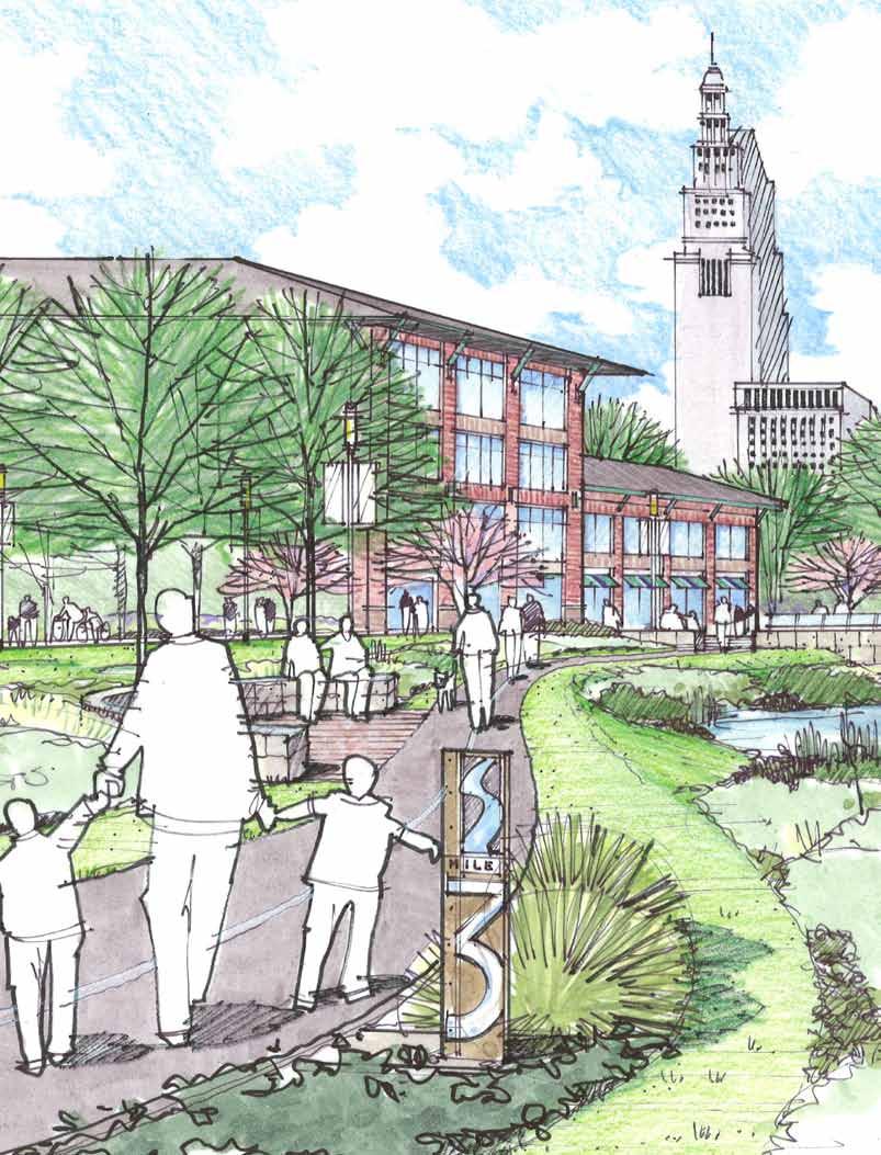
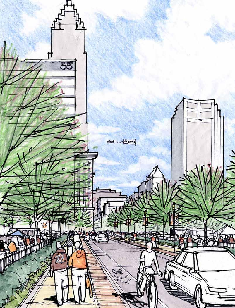
30 the existing Willow Avenue Vertical Lift Bridge, if feasible. This exclusively cyclist and pedestrian bridge will provide the advantage of separating motorized and non-motorized traffic and contribute greatly to public safety by avoiding potential conflicts between trail users and the truck traffic on the Willow Avenue Vertical Lift Bridge. Like Option C-4a, above, this connection will also require a grade-separated crossing over or under the Norfolk Southern Railroad tracks. Homeland Security issues will have to be addressed during the design of the trail s proposed path in this location. C-5 Connections to Edgewater Park and Wendy Park C-5a Off-Road Trail Connection Along Cleveland Memorial Shoreway, Connecting to Edgewater Park This connection is part of the Cleveland Lakefront Bikeway and is included in the Cleveland Bikeway Master Plan. C-5b Off-Road Trail Connection Between Whiskey Island/Wendy Park and Edgewater Park Provide a multi-purpose trail (10 to 12 feet wide) from Edgewater Park to Whiskey Island and Wendy Park along Ed Hauser Way. Include appropriate signage so that potential users are aware of the attractions at the east end of the park, including the U.S. Coast Guard Station. The Canal Basin District Plan, Cleveland, Ohio Final Report page 34 C-6 Connections Along the West Side Rim Provide trail connections that link west side destinations with the Towpath Trail and Canal Basin Park. C-6a Detroit-Superior Bridge Connection This connection exists and is part of the Cleveland Lakefront Bikeway. C-6b Superior Viaduct Provide a bike/pedestrian trail connection along Superior Viaduct from West Twenty-Fifth Street to the end of Superior Viaduct. This will have to be a shared-used connection, due to the limited right-of-way and the need to accommodate and maintain the existing on-street parking. C-6c West Twenty-Fifth Street/Cuyahoga Metropolitan Housing Authority (CMHA) Towers/West Side Market/GCRTA Station Provide a bike/pedestrian trail connection along the West Twenty-Fifth Street corridor between Superior Viaduct and Abbey Avenue. The trail will run along West Twenty-Fifth Street at the north end, travel east of the CMHA towers, then through the West Side Market parking area and connect to GCRTA s West Twenty-Fifth Street-Ohio City Station. The expectation for the north end of the connection, along West Twenty-Fifth Street, is that the street will be narrowed and the sidewalk area will be widened so that an off-road multi-purpose trail (10 to 12 feet wide) will be provided for this connection. C-6d Franklin Avenue Provide a bike/pedestrian trail connection along the Franklin Avenue corridor between Columbus Road and West Twenty-Fifth Street, connecting to the city s bike route system along Franklin Avenue to the west of West Twenty- Fifth Street. This connection will be an off-road, multi-purpose trail (10 to12 feet wide). This trail connection is affected by the slope stability issues along the Riverbed Street hillside. Current estimates to fix the hillside range from $25 to $250 million. Framework A composite framework plan was developed that highlights the three Canal Basin District sub-areas and delineates the viable trail loops and connections within each sub-area. This will ensure that the Canal Basin District Plan functions both as a connection to the Towpath Trail and the Ohio & Erie Canalway America s Byway, and as a neighborhood system of interconnecting trails. Refer to Figure 9. The Canal Basin District Plan has identified many potential trail connections. They vary in configuration, construction cost and characteristics. Identifying separate trail connections makes the plan flexible, allowing the connections to be made as funding becomes available. It also provides opportunities for special interest groups to sponsor a trail, which may speed plan implementation. A series of perspective sketches has been developed to help illustrate the character of the proposed trail systems and the potential opportunities for trail improvements. Refer to Figures 10 through 14.
31 PURPOSE OF THE PLAN The Ohio Canal Corridor, Downtown Cleveland Alliance and the City of Cleveland have partnered to conduct a conceptual study that identifies a future pedestrian and bicycle network within the northern section of the Cuyahoga River Valley that seeks to link adjacent neighborhoods into the developing Towpath Trail system. The study addresses the growing need to provide safe and efficient access from Downtown Cleveland and surrounding urban neighborhoods to the Towpath Trail and Canal Basin Park. Its conclusions combine to provide a road map for future public and private investment decisions that can lead to establishing the Cuyahoga River Valley as a major attraction for residents and visitors, alike. The final plan document is designed to serve as the template upon which behavioral patterns in coming years may be affected, as area residents along the Towpath Trail replace the traditional carbon-burning car ride to work and play mentality with a calorieburning bike to work and play activity. Enhancing the Ohio & Erie Canalway The Ohio & Erie Canalway is a recognized National Heritage Area designated by an act of Congress in 1996 with re-authorization in The Congressional designation required the development of the Corridor Management Plan that will define the Heritage Area and answer the questions involving interpretive storylines and themes, and visitor experience and use. Seventy-five public meetings were held along the proposed boundary of the Ohio & Erie Canalway America's Byway to develop the recommendations found in the Corridor Management Plan. That public involvement shaped a plan that called for active exploration of the stories and places that included three transportation options: (1) Cuyahoga Valley Scenic Railroad, (2) Ohio & Erie Canalway America s Byway, and (3) the Towpath Trail system. page 41 The Canal Basin District Plan, Cleveland, Ohio Final Report
32 Integral to these transportation links was the siting of four Canalway Centers where visitors can find information, orientation and interpretive content. The formula for site selection for the Canalway Centers prioritized locations where all three transportation options were readily available. An equal requirement was to celebrate places/sites where the history of the Canalway is prominent. In the case of Cleveland, that formula provided a model solution. Cleveland plays host to the terminus of the Canalway as it enters the Cuyahoga River. This place, now referred to as Canal Basin Park, was Cleveland s first port. It was here that the Towpath historically ended, and it is here where the Towpath Trail will end, along with the designated Ohio & Erie Canalway America s Byway. In addition, the Cuyahoga Valley Scenic Railroad shows its northern terminus at a location just below Tower City at river level, a short stroll from Canal Basin Park. In reading the Corridor Management Plan carefully, however, the Towpath Trail is not depicted as a solitary trunk trail, but rather, one with connector or branch trails that extend to link communities, neighborhoods and attractions. It is with this model in mind that a number of trail spurs have been planned and built. It is with this model in mind that the Canal Basin District Plan approached the planning exercise to identify such opportunities. Current Situation Today, the Towpath Trail in the Cuyahoga Valley National Park (CVNP) attracts 1.8 million users per year. The adjoining Cleveland Metroparks Canal Reservation (Rockside to Harvard) sees 447,000 users per year. It is anticipated that the usage in this northern end, Canal Basin District, will grow dramatically once the Towpath Trail connects directly into the Tremont neighborhood and even more so once it reaches its destination at Canal Basin Park and the adjoining Downtown residential districts. Some have predicted even greater usage in the urban core than that in the CVNP. The current project schedule shows that the Towpath Trail will extend from its current terminus at lower Harvard Avenue to Canal Basin Park in Project Goals While Canal Basin Park will offer a package of exceptional visitor amenities as a destination, there is a consensus that we need to encourage Towpath Trail users to explore affiliated sites and attractions, and to do so in a safe and friendly environment. The goal of the Canal Basin District Plan is to identify a series of safe, off-road bike/hike connections between the Towpath Trail, Canal Basin Park and identified visitor destinations. The Canal Basin District Plan, Cleveland, Ohio Final Report page 42 The planning process was undertaken with no preconceived ideas concerning the feasibility of individual routes. Rather, it sought input through a series of public meetings that employed formalized study boundary geography within which: Visitor sites and attractions were identified and refined. Off-road trail connector ideas were solicited. Feasibility of proposed routes was vetted with interested businesses, landowners, government agencies and other stakeholders. Visitor destinations include the following: Edgewater Park Wendy Park Old Superior Viaduct Ohio City/West Side Market Historic Warehouse District Public Square Gateway Sports Complex/Progressive Field and Quicken Loans Arena Cleveland s Convention Center/Mall North Coast Harbor (Rock and Roll Hall of Fame, Great Lakes Science Center, Mather Museum)
33 Plan Process and Implementation The plan does not attempt to prioritize the proposed trail connections. Instead, it offers a conceptual framework from which follow-up studies will be needed to address individual challenges cited within the descriptive text or the accompanying matrix (Appendix D). Its purpose is to provide the City of Cleveland s planning staff with a documented approach to creating a system of pedestrian- and bike-friendly off-road trails so that these ideas may be passed along to agencies, private and public, looking to redevelop portions of our Cuyahoga River Valley and lakefront. The expected outcome of this exercise is that the connector trails and pedestrian ways will be formally integrated within future development plans. Cleveland s Flats East Bank project and the Port of Cleveland s Lakefront Master Plan are prime examples of current plans and developments that should integrate the findings of this study new mixed-use communities are planned along the Cuyahoga River and Lake Erie. Any future development plans for the Scranton Peninsula, Columbus Peninsula and the Flats West Bank should do likewise. The plan also introduces two companion concepts as outcomes: (1) The development of a waterfront public access system that creates a miniature Emerald Necklace of trails and riverfront parks within the northern end of the Cuyahoga River Valley and (2) a system of trail loops that offer users route options that provide variety to their experiences. The options for implementation are many: Cuyahoga County purchased parkland on Cleveland s lakefront now known as Wendy Park with the intention of eventually developing a connection to the Towpath Trail. Recently, they enlisted a new non-profit, Building Cleveland by Design, to lead an effort to provide this connection. Referred to as the Lake Link Trail, this connector trail will extend northward from the Towpath Trail at Scranton Road through Irishtown Bend and an abandoned rail corridor towards Wendy Park. This alignment has drawn both visible support and vocal opposition. A link between Wendy Park and Edgewater Park can serve to link Wendy Park to the state s lakefront park system and, in doing so, open a dialogue with the Ohio Department of Natural Resources about the adoption of Wendy Park. There is an existing organizational framework, Towpath Trail Partnership Committee, that is managing the extension of the Towpath Trail from Harvard Avenue to Canal Basin Park. They are capable of adopting individual segments of the concept plan as they complete the trunk trail. Other organizations, public and private, can play a major role in the implementation process. During implementation, it is important that key considerations are addressed properly, especially if federal transportation funds will be used. They include: Finding 20 percent local matching funds (non-federal). Partnering with a government agency that is qualified and capable to manage federal transportation funds through the Ohio Department of Transportation process. Identifying the owner of the project. Identifying a management/operational agency for the project. The Canal Basin District Plan represents the first step in a long journey. It is a guide to a pedestrian/bike-friendly experience for future Ohio & Erie Canalway America's Byway visitors. Its relevance will be gauged by the quantity and quality of successful connections that Cleveland will build. page 43 The Canal Basin District Plan, Cleveland, Ohio Final Report

34 The Canal Basin District Plan, Cleveland, Ohio Final Report page 44
35 APPENDIX A Technical Advisory Committee page 45 The Canal Basin District Plan, Cleveland, Ohio Final Report
36 Canal Basin District Plan Draft Planning Study Report April 2009 The Canal Basin District Plan, Cleveland, Ohio Final Report page 46 Canal Basin District Plan Technical Advisory Committee Name Organization Phone Address Justin Glanville Building Cleveland By Design jglanville@paperworks.org Chris Gill Cargill chris_gill@cargill.com Bob Brown Cleveland rnbrown@city.cleveland.oh.us Eric Wobser Cleveland ewobfer@city.cleveland.oh.us Mark Lammon Cleveland DCA mlammon@cacleveland.net Susan Miller Cleveland Heights millerbowen@adelphia.net Greg Peckham Cleveland Public Art gpeckham@ Carrie R. Hansen Cleveland Parks chansen@city.cleveland.oh.us John Veres Cleveland Waterfront Coalition veresa@sbcglobal.net Paul Alsenas Cuyahoga County Planning palsenas@cuyahogacounty.us Carol Thaler Cuyahoga County Planning cthaler@cuyahogacounty.us Elaine Price Cuyahoga County Planning eprice@cuyahogacounty.us Stan Kosilesky Cuyahoga County Engineer skosilesky@cuyahogacounty.us Jim White Cuyahoga River RAP whitej@cuyahogariver.org Dan Moore DT MC - Wendy M dtm@mantmoore.com Jim Cox Flats Industry jimcoxiii@sbcglobal.net Tom Newman Flats Oxbow Association flatsoxbow@ameritech.net Ed Hauser Friends of Whiskey Island ejhauser@ameritech.net Peter Griesinger Gates Mills peters@griesingerfilms.com David Beach GCB Institute dbeach@cmnh.org John Mitterholzer Gund Foundation jmitterholzer@gundfdn.org Thomas Starinsky HAH - HWD tstarinsky@warehousedistrict.org John Tepfenhart KA Architecture jtepfenh@kainc.com Paula Lewis LaFarge North American paula.lewis@laforge-na.com Mahmoud Al - lozi NOACA mallozi@mpocoaca.org Michelle Johnson NOACA mjohnson@mponoaca.org Abe Bruckman OCNW abruckman@ohiocity.org John Motl ODOT john.motl@dot.state.oh.us Eric Oberg Rails to Trails eric@railstotrails.org Martha Eakin Shaker Heights meakin@sbcglobal.net Chris Garland TWDC chrisgarland@twdc.inc Sammy Catania TWDC sammycatania@twdc.org Bill Montville Citizen Tom Yablonsky DCA tyablonsky@dcacleveland.net George Cantor City of Cleveland gcantor@city.cleveland.oh.us Tim Donovan Ohio Canal Corridor tdonovan@ohiocanal.org Brian Charlton JJR brian.charlton@jjr-us.com Pat Doher JJR patrick.doher@jjr-us.com Gregg Calpino JJR gregg.calpino@jjr-us.com Nancy Lyon Stadler Baker nlyonstadler@mbakercorp.com 20
37 APPENDIX B TAC and Public Meeting Minutes page 47 The Canal Basin District Plan, Cleveland, Ohio Final Report
38 MEETING MINUTES Page 1 of 2 Cleveland Canal Basin District Plan July 29, 2008 September 08, 2008 PROJECT PROJECT NO. MEETING DATE ISSUE DATE KA Design Center Public Meeting #1 MEETING LOCATION MEETING PURPOSE Nancy Lyon Stadler / Elizabeth Iszler ISSUED BY PARTICIPANT See Attached Sign-In Sheet COMPANY DISCUSSION The first public meeting for the Canal Basin District Plan was held in the KA Design Center on West 9 th Street. The meeting started with a welcome and introduction to the project by Tim Donovan (Ohio Canal Corridor) with support from George Cantor (City of Cleveland, Planning) and Tom Yablonsky (Downtown Cleveland Alliance), the other members of the project's steering committee. Tim, George and Tom gave a presentation on the project that covered the following areas: Welcome Community Participation Consultant Selection Process Ideas for Consideration Planning Process Today s Exercise Next Meeting Date The Canal Basin District Plan, Cleveland, Ohio Final Report page 48 After the formal presentation, the TAC members divided into three groups to brainstorm and develop ideas for the project, focusing on trail connections between the park and potential destinations of interest within the study area as well as potential routes for those connections. A summary of the ideas generated are provided below. After the brainstorming session, everyone reconvened and each group presented and reviewed their ideas for the assembled TAC members. This generated some general discussion about the project. Before leaving the meeting, everyone was asked to complete a project questionnaire, another means of obtaining their feedback on the project and potential trail connections. View Towpath Trail as a tree with branches, not a single line/trail. Create new Emerald Necklace. Canal Basin Park is 24 acres and connects river to river. A concern was voiced by Jim Cox (Flats Industry) regarding truck traffic in the Flats, specifically on the Willow Avenue Vertical Lift Bridge, and the importance of considering truck traffic and travel patterns as the park trail connections are being planned. Jim Cox wants to show Flats truck video to the public. Ed Hauser offered to give a tour of Whiskey Island for consultant team ( ; ejhauser@ameritech.net). J J R, L L C M I L L E R A V E N U E, A N N A R B O R, M I C H I G A N T F
39 MEETING MINUTES Canal Basin District Plan Public Meeting #1 JJR No July 29, Page 2 of 2 If this report does not agree with your records or understanding of this meeting, or if there are any questions, please advise the writer immediately in writing; otherwise, we will assume the comments to be correct. P:\50095\000\Admin\Project Management\mtgnotes\meeting # \ Public Mtg.doc Attachment: Sign-In Sheet DISTRIBUTION George Cantor / City of Cleveland Tim Donovan / Ohio Canal Corridor Tom Yablonsky / Downtown Cleveland Alliance Nancy Lyon Stadler / Michael Baker Corporation Patrick Doher / JJR, LLC Elizabeth Iszler / JJR, LLC Chad Brintnall / JJR, LLC Gregg Calpino / JJR, LLC page 49 The Canal Basin District Plan, Cleveland, Ohio Final Report
40 Canal Basin District Plan Public Meeting #1 Questionnaire July 29, :00 pm 8:00 pm 1. Do you live / work / recreate in downtown Cleveland? (circle all that apply) 2. Potential trail connections to the Canal Basin Park are listed below. Please rate the importance of these trail connections (1=very important/desirable, 2=somewhat important/desirable, 3=nice to have but not necessary, 4=not important/desirable). Edgewater Park Whiskey Island/Wendy Park North Coast Harbor Overlook Park in the Warehouse District Existing Lakefront Bikeway Ohio City - West Side Market Old Superior Viaduct Irishtown Bend Hart Crane Park Flats East Bank Development Stonebridge Development Public Square Gateway Plaza Euclid Corridor 3. What other trail connections would you like to see? 4. What did you see on the Detroit RiverWalk video that you would like to incorporate here? The Canal Basin District Plan, Cleveland, Ohio Final Report page What can we do to make the connections attractive/attract people and how should we do it? (i.e., make it feel safe by providing good lighting and regular patrol by police officers on bicycles) 7. What other cities you have visited where you really enjoyed their parks and greenways? 8. Additional thoughts? (please feel free to use the back of the sheet)

41 page 51 The Canal Basin District Plan, Cleveland, Ohio Final Report


42 Planning Exercise Public Meeting July 29, 2008 Broke into teams Identified possible trail/pedestrian connectors Each group began SWOT analysis for individual routes Questionnaires / feedback Public Meeting #1 Recap The Canal Basin District Plan, Cleveland, Ohio Final Report page 52
 CBP to Federal Court House Eagle Ave. Tower City Amphitheater to Ontario Ave.")
43 Some of the Comments we heard Public Meeting #1 Compilation Plan Utilize lower level of Detroit Superior Bridge Bridge Railroad tracts to get to Wendy Park Bike lanes are needed on W. 25th Street Edge of Scranton Road Peninsula (Columbus to Center Street Bridge) CBP to Federal Court House Eagle Ave. Tower City Amphitheater to Ontario Ave. Connect to other Lakefront Parks Connection down to Columbus Road and up to Ohio City Recessed rail line Trench Pedestrian bridge to west bank in Jackknife bridge R.O.W. Linkage to proposed Gateway Bike Garage Funnel Ohio City Street to Franklin Bluff above Irishtown Bend Public Meeting #1 page 53 The Canal Basin District Plan, Cleveland, Ohio Final Report
44 MEETING MINUTES Page 1 of 4 Cleveland Canal Basin District Plan July 29, 2008 September 08, 2008 PROJECT PROJECT NO. MEETING DATE ISSUE DATE KA Design Center Technical Advisory Committee Meeting #1 MEETING LOCATION MEETING PURPOSE Nancy Lyon Stadler / Elizabeth Iszler ISSUED BY PARTICIPANT Tim Donovan Tom Yablonsky George Cantor John Mitterholzer Elaine Price Pat Doher See Attached Sign-In Sheet for Additional Attendees COMPANY Ohio Canal Corridor Downtown Cleveland Alliance City of Cleveland Gund Foundation Cuyahoga County Planning Commission JJR, LLC DISCUSSION The first Technical Advisory Committee (TAC) meeting for the Canal Basin District Plan was held in the KA Design Center on West 9th Street. The meeting started with a welcome and introduction to the project by Tim Donovan (Ohio Canal Corridor) with support from George Cantor (City of Cleveland, Planning) and Tom Yablonsky (Downtown Cleveland Alliance), the other members of the project's steering committee. Tim, George and Tom gave a presentation on the project that covered the following areas: The Canal Basin District Plan, Cleveland, Ohio Final Report page 54 Welcome Community Participation Consultant Selection Process Ideas for Consideration Planning Process Today s Exercise Next Meeting Date After the formal presentation, the TAC members divided into three groups to brainstorm and develop ideas for the project, focusing on trail connections between the park and potential destinations of interest within the study area as well as potential routes for those connections. The TAC reconvened and each group presented and reviewed their ideas for the assembled TAC members. A summary of the ideas generated are provided below. Possible connections to Towpath Trail include: Mill Creek Treadway Zoo and Rain Forest Big Creek Memphis Reservation Train Avenue J J R, L L C M I L L E R A V E N U E, A N N A R B O R, M I C H I G A N T F
45 MEETING MINUTES Canal Basin District Plan TAC Meeting #1 JJR No July 29, Page 2 of 4 Canal Basin Park is the termination of the Towpath Trail where historically the canal ended at the lake. Potential connections to the Canal Basin District Plan were discussed: River Valley Connections in/out of valley a system of trails is needed to connect to important areas beyond Canal Basin Park. Reference the Detroit RiverWalk as an example. Northwest study area boundaries include East 9 th Street, Euclid Avenue corridor, West 41 st Street, (Detroit Shoreway and Ohio City) and West 25 th Street. Community participation is broad and diverse. Involve land owners, community leaders, and the TAC. Consultant selection was discussed. Ideas for consideration: Reclaim, Celebrate the topography and the urban forests. Irishtown bend is one of few remaining green areas. Columbus Road peninsula is underutilized place. Gravity place and Columbus Road create a new central park. History of the Cuyahoga River is the poster child for the Clean Water Act. Unify the Flats and Cuyahoga River (historically a dividing line). Valley is the showcase/centerpiece of sustainability. Detroit RiverWalk has similarities to the Cuhahoga River Valley. A short video was shown about the Detroit RiverWalk. For the interim plan, identify possible bike/pedestrian connections to and from Towpath Trail and Canal Basin Park. Canal Basin District Plan is 24 acres from river to river. This will be a new way to look at downtown Cleveland. The Canal Basin District Plan should be a system, which is why it is called a district. For the interim plan, identify all possible linkages to adjacent neighborhoods and the downtown. Destinations include the following: Edgewater Park Whiskey Island/Wendy Park North Coast Harbor Overlook Park in the Warehouse District Existing Lakefront Bikeway Ohio City West Side Market Old Superior Viaduct Irishtown Bend Hart Crane Park Flats East Bank Development Stonebridge Development Public Square Gateway Plaza Euclid Corridor page 55 The Canal Basin District Plan, Cleveland, Ohio Final Report
46 MEETING MINUTES Canal Basin District Plan TAC Meeting #1 JJR No July 29, Page 3 of 4 The Canal Basin District Plan, Cleveland, Ohio Final Report page 56 Cuyahoga River Detroit Superior Bridge Into Neighborhoods For the preliminary plan, assess feasibility of possible connections through SWOT (Strengths, Weaknesses, Opportunities, Threats) analysis and estimated costs. For the final plan, provide preferred options, a report to document decision making, and recommendations for basic standards for connections. Take a comprehensive look at the riverfront. Don t think of the river as a boundary, but as a unifier/linkage. The goal of the plan is to have a path/trail within a few-minute bike ride of every resident of Cleveland. The group broke up into teams to perform a SWOT analysis. Clarify purpose. Is it a riverfront or connections plan? It is a connection plan, but the riverfront is part of it. The success of the Detroit RiverWalk can help in terms of foundations, funding, ideas, etc. Consider modes, methods, and access by water. Project Timeline and End Point Will there be a cost estimate to help evaluate connections? Will there be time to identify, assess, and put rough costs to it? What are the park boundaries? There will be three breakout groups to identify potential connections facilitated by George Cantor, Tom Yablonsky, and Tim Donovan. Connect to east bank boardwalk. Connect to North Coast Harbor, off the road, if possible. Add trail/path along waterfront line/new bridge. Easton property Connect Whiskey Island to east bank across mouth of the river Hands Across the River connection to mass transit. Connect north end of Wolstein development under north-south bridge to Hands Across the River Bridge. Provide an on-street bike connection along Superior Avenue to the Public Square and Euclid Avenue. Connect along RTA Red Line bridge. Use the existing space for bicycle/pedestrian access. The space is tight where the rail line ties into Tower City; that is a hurdle that would need to be addressed. Accommodate recreation and commuter cyclists. Provide a mix of uses. Create a system for cyclists. Consider maintenance, extended season for commuters. Connect to proposed bike station, East 4 th Street and Huron Road, CVSR, and rowing foundation. Provide an on-road and off-road connection that feels safe for cyclists. Provide a trail connection along the abandoned rail corridor along Riverbed Street, through the tunnels by Stonebridge, and between Center Street and Mulberry Avenue to River Road, enabling a connection to Edgewater Park, Whiskey Island, and coast Guard station.
47 MEETING MINUTES Canal Basin District Plan TAC Meeting #1 JJR No July 29, Page 4 of 4 Incorporate Lakefront Plan bikeway. Extend commuter route along Columbus Road. Conduct a SWOT analysis for connections to North Coast Harbor and Coast Guard station. Consider the organization/collaboration that will be necessary to implement the plan. Think big! This is a once in a lifetime opportunity. Think outside the box. Talent/vision is needed to incorporate sustainable practices into Towpath III. The next meeting will take place Tuesday, September 16. If this report does not agree with your records or understanding of this meeting, or if there are any questions, please advise the writer immediately in writing; otherwise, we will assume the comments to be correct. P:\50095\000\Admin\Project Management\mtgnotes\meeting # \ TAC Mtg.doc Attachment: Sign-In Sheet DISTRIBUTION George Cantor / City of Cleveland Tim Donovan / Ohio Canal Corridor Tom Yablonsky / Downtown Cleveland Alliance Nancy Lyon Stadler / Michael Baker Corporation Patrick Doher / JJR, LLC Elizabeth Iszler / JJR, LLC Chad Brintnall / JJR, LLC Gregg Calpino / JJR, LLC page 57 The Canal Basin District Plan, Cleveland, Ohio Final Report
48 The Canal Basin District Plan, Cleveland, Ohio Final Report page 58


49 TAC Meeting July 29, 2008 Broke into teams Identified possible trail/pedestrian connectors Each group began SWOT analysis for individual routes Questionnaires / feedback Planning Exercise page 59 The Canal Basin District Plan, Cleveland, Ohio Final Report TAC Meeting #1 Recap

50 The Canal Basin District Plan, Cleveland, Ohio Final Report page 60 Some of the Comments we heard TAC Compilation Plan Use Irishtown Bend as quick solution for connectivity no land acquisition problems. Columbus Road and Franklin Ave. are connectors from West Side Market Detroit Superior Bridge promenade connects East and West side Go through flats East bound to North Coast Harbor CBP down to Center Street to Lift Bridge to Whiskey Island Connect all Lakefront Plan linkages Analyze linkages under the Main Ave. Bridge Edgewater connection Ohio City/Detroit Shoreway north route Long term University Street may not connect to Scranton Tremont Connector Compile list of all infrastructure projects planned within project area Connect to West Sixth Overlook Park Historic Warehouse District Public Realm Plan TAC Meeting #1
51 MEETING MINUTES Page 1 of 4 Cleveland Canal Basin District Plan September 16, 2008 September 25, 2008 PROJECT PROJECT NO. MEETING DATE ISSUE DATE KA Design Center Public Meeting #2 MEETING LOCATION Elizabeth Iszler/Nancy Lyon Stadler ISSUED BY MEETING PURPOSE Provide information on conceptual alternatives. Discuss concepts with and obtain feedback from the public. PARTICIPANTS Tim Donovan Tom Yablonsky George Cantor Elizabeth Iszler Gregg Calpino Pat Doher Nancy Lyon Stadler See attached sign-in sheet for complete list of attendees. COMPANY Ohio Canal Corridor Downtown Cleveland Alliance City of Cleveland - Planning JJR JJR JJR Michael Baker Jr., Inc. DISCUSSION The second public meeting for the Canal Basin District Plan was held in the KA Design Center on West 9th Street in Cleveland, Ohio. The meeting started with a welcome by George Cantor (City of Cleveland Planning Commission). He discussed the project and its objectives, the process, and the incorporation of everyone s ideas into the plan s development process. The purpose of the meeting, as stated, was to further define the community s expectations and desires for connecting Canal Basin Park to area amenities and destinations. George turned the meeting over to Pat Doher of JJR, who led the formal presentation. The formal presentation was followed by a group work session facilitated by the project team, where the concepts for each sub-area were studied and evaluated with respect to how they meet the project goals, potential conflicts or hurdles, and other related topics of discussion. The formal PowerPoint presentation is attached. Jim Cox (Flats Industry) presented a video that documented industrial truck traffic in the Flats, focusing on the truck traffic on the Willow Lift Bridge. Speaking for his industrial constituents (businesses in the Cuyahoga River Valley), Jim expressed strong concern regarding the mixing of bicycle and pedestrian traffic on the Willow Lift Bridge based on safety concerns with the conflicting modes. He felt that access to Whiskey Island and Wendy Park needs to be done in a safe way that does not have a negative impact on the existing industries and businesses. Comments from the group discussions are listed below: General Comments J J R, L L C M I L L E R A V E N U E, A N N A R B O R, M I C H I G A N T F page 61 The Canal Basin District Plan, Cleveland, Ohio Final Report
52 MEETING MINUTES Canal Basin District Plan Public Meeting #2 JJR No September 16, Page 2 of 4 There will be layers (varieties) of users recreational, residential, commuter. Although the design standard is the recreational user, all user groups need to be considered in developing the trail connections. Growth of downtown housing: Downtown is a source of users of the Towpath and its trail connections Create trail character with signing, lighting, materials, pavement (good example is the Indianapolis Cultural Trail) Consider street closures for trails without motorized vehicle conflicts Signage and wayfinding is very important Need to talk to planned and future development opportunities to discuss plan and its implementation (Wolstein s East Bank Development; Tower City and the proposed Convention Center; others) Coordinate project with RTA Provide links to RTA lines; consider re-routing and/or extending bus routes/trails to make connections. Downtown / Neighborhood Connections Connect to identified destinations Lakefront North Coast Harbor and Cleveland Browns Stadium Public Square Provide Riverwalk below Tower City The Canal Basin District Plan, Cleveland, Ohio Final Report page 62 West Side connection: Investigate proposed/potential connections. RTA Bridge (red line) Columbus Road Frequent trail users will want to include good access to/within the downtown area Visitors staying downtown need trail for connections for running, walking and bicycling (assuming bike rental facilities) Need to provide destination linkages for users Provide connection between the river and the upper level roadway network Visitor information center is located at the Higby Building (Public Square). Important to make a connection to this location. Provide vertical circulation (river to rim / upper level roads) off-road as much as possible Lakefront Can mix / match pieces from the various options
53 MEETING MINUTES Canal Basin District Plan Public Meeting #2 JJR No September 16, Page 3 of 4 Clarification on connection to Whiskey Island by Ed Houser: There is a lot of truck traffic on the Willow Lift Bridge, as shown in the video. The video projects not using the Willow Lift Bridge for non-motorized traffic use. We need to look at alternatives to Willow crossing. Counter to the comments made by Jim Cox, there have been substantial changes in the area around the Old River Channel and along the lakefront since The area has become a public park, established a public marina, USCG Station. Access to Whiskey Island is critical, need to provide maximum linkages to this area. Important to provide a link across the river to Close the Loop on Emerald Necklace (100+ mile loop) Option 1 should be the vision, even if it takes a long time to achieve Not providing direct link to Whiskey Island may discourage users. Access is ok with a loop. Remote access only is less desirable. Truck Traffic: Is anyone looking at a truck alternative? Is there another way to get trucks off Whiskey Island? The more development that happens the more challenging it will be for trucks. Center Street is a relatively fragile bridge, too narrow to comfortably accommodate bicycles. Use Front Street as route? CBP Heart Defined routes within the Towpath plan: main route and secondary route along the abandoned rail corridor/riverbed Street alignment Concern with property owned by Forest City on Scranton Peninsula. Project team should talk with Forest City (Will Voegle) regarding the Canal Basin District Plan development and potential support from Forest City. Should not plan on using Center Street Swing Bridge for trail, too narrow Short bridge could use it if reduce speed limit Jim Sheehan, Ohio City Bicycle Coop uses it with his kids all the time, not so bad Concern with sight distance (Jim Cox) Consider off road trail along Columbus Peninsula: off road between Columbus Road and the river, going upriver) Need to avoid conflict with flats industrial railroad Interest in amenities along the CBP loop trail place to have picnics Slave emancipation route historically interesting old stone church, others need off-road route for national organization participation page 63 The Canal Basin District Plan, Cleveland, Ohio Final Report
54 MEETING MINUTES Canal Basin District Plan Public Meeting #2 JJR No September 16, Page 4 of 4 Kevin Cronin has details Need ingress/egress for adventure cycles / national maps Work with Western Reserve Historical Society for destinations Cuyahoga is American Heritage River; include in interpretive areas Jim White (Cuyahoga RAP, River Navigator) can provide detailed information Provide bike station and bike rental facility (in park) Consider providing a place for Huletts cultural element Hulett placement some talk of putting in east bank (very tentative) Landmarks Commission: After 5 years, Huletts will be stored in boat house (Ed Hauser) Provide link to Cuyahoga Valley Scenic Railroad (CVSR) extension/future end point Summary Will use information and comments provided to move to next step, development of recommended alternative Project team will develop a phased plan which will be presented to the TAC and the public for feedback If this report does not agree with your records or understanding of this meeting, or if there are any questions, please advise the writer immediately in writing; otherwise, we will assume the comments to be correct. p:\50095\000\admin\project management\mtgnotes\meeting # \ public mtg #2.doc Attachments: 1. Sign-In Sheet The Canal Basin District Plan, Cleveland, Ohio Final Report page 64 DISTRIBUTION George Cantor / City of Cleveland Tim Donovan / Ohio Canal Corridor Tom Yablonsky / Downtown Cleveland Alliance Nancy Lyon Stadler / Michael Baker Jr., Inc. Patrick Doher / JJR, LLC Elizabeth Iszler / JJR, LLC Chad Brintnall / JJR, LLC Gregg Calpino / JJR, LLC
55 page 65 The Canal Basin District Plan, Cleveland, Ohio Final Report September 16, 2008
56 The Canal Basin District Plan, Cleveland, Ohio Final Report page 66 September 16, 2008
57 page 67 The Canal Basin District Plan, Cleveland, Ohio Final Report September 16, 2008
58 MEETING MINUTES Page 1 of 5 Cleveland Canal Basin District Plan September 16, 2008 September 25, 2008 PROJECT PROJECT NO. MEETING DATE ISSUE DATE KA Design Center Technical Advisory Committee Meeting #2 MEETING LOCATION Elizabeth Iszler/Nancy Lyon Stadler ISSUED BY MEETING PURPOSE Provide information on conceptual alternatives. Discuss concepts with and obtain feedback from the TAC. PROJECT TEAM Tim Donovan Tom Yablonsky George Cantor Elizabeth Iszler Gregg Calpino Pat Doher Nancy Lyon Stadler See attached sign-in sheet for complete list of attendees. COMPANY Ohio Canal Corridor Downtown Cleveland Alliance City of Cleveland - Planning JJR JJR JJR, LLC Michael Baker Jr., Inc. DISCUSSION The Canal Basin District Plan, Cleveland, Ohio Final Report page 68 The second Technical Advisory Committee (TAC) meeting for the Canal Basin District Plan was held in the KA Design Center on West 9th Street in Cleveland, Ohio. The meeting started with a welcome by Bob Brown (Director of the City of Cleveland Planning Commission). He discussed the project and its objectives, the process, and the incorporation of everyone s ideas into the plan s development process. The purpose of the meeting, as stated, was to further define the community s expectations and desires for connecting Canal Basin Park to area amenities and destinations. Bob turned the meeting over to Pat Doher of JJR, who led the formal presentation. The formal presentation was followed by a group work session facilitated by the project team, where the concepts for each sub-area were studied and evaluated with respect to how they meet the project goals, potential conflicts or hurdles, and other related topics of discussion. The formal PowerPoint presentation is attached. Jim Cox (Flats Industry) presented a video that documented industrial truck traffic in the Flats, focusing on the truck traffic on the Willow Lift Bridge. Speaking for his industrial constituents (businesses in the Cuyahoga River Valley), Jim expressed strong concern regarding the mixing of bicycle and pedestrian traffic on the Willow Lift Bridge based on safety concerns with the conflicting modes. He felt that access to Whiskey Island and Wendy Park needs to be done in a safe way that does not have a negative impact on the existing industries and businesses. At the close of the meeting, TAC members requested that the PowerPoint presentation be posted on line to enable further review and to solicit more comments from the TAC. Consider ing a list of questions or questionnaire to TAC members with distribution of the meeting minutes with the presentation. J J R, L L C M I L L E R A V E N U E, A N N A R B O R, M I C H I G A N T F
59 MEETING MINUTES Canal Basin District Plan TAC Meeting #2 JJR No September 16, Page 2 of 5 The next meeting is currently scheduled for Tuesday, November 11th. Comments from the group discussions are listed below: General Comments There are two primary trail spines that will be served by Canal Basin Park. They are the Towpath Trail and the Lakefront Trail. Bike station(s) and bike amenities should be provided to accommodate bicyclists. The bicycle amenities could include lockers and/or other means of safely securing bicycles, bicycle rental facilities, and bicycle maps, information guides, etc. Designate Network of Streets: The area around Canal Basin Park will function as a watershed, feeding into Canal Basin Park. There should be a hierarchy to the connections, with preference for off-road trails. On-street links may be provided but offroad trails are more desirable. Recreational cyclists are the design user. The trails will also accommodate higher type users, but the trails will be designed for the recreational cyclist. There will be an array of target markets; this concept should facilitate accommodation of the variety of markets. Will there be family programs at CBP? Park programs have not yet been developed. It is likely that the trail connectivity can guide the development of the park and its programs. CBDP needs to be linked to and work with the City s Bike Plan and NOACA s regional bike plan and priority network. Consider ways to provide connections to these two networks. Can mix / match components of the various options. Would be best to implement lowest cost and easiest options first to create momentum and to open up additional funding opportunities. Need to consider hierarchy of potential trail connections. Consider physical and cost constraints. Start project (phase 1) with connections that will be easiest and least expensive to construct. Making a T connection between the Towpath and Lakefront trails should be expressed as a project goal. Downtown / Neighborhood Connections West Side Market & RTA Station via RTA Red Line Viaduct: This connection was generally viewed as a good idea, if it will work. Concern was expressed regarding how to access the connection at both ends. The project team needs to coordinate with RTA and the justice center to determine if it is a feasible alternative. Downtown Given the constraints of the downtown roadway network, the group generally agreed that it makes sense to provide more pedestrian than bike access. page 69 The Canal Basin District Plan, Cleveland, Ohio Final Report
60 MEETING MINUTES Canal Basin District Plan TAC Meeting #2 JJR No September 16, Page 3 of 5 It is important to clearly mark/identify the trail connections so that they will be uniquely recognizable even if they are part of the city s street network. This may include special pavement colors and/or treatments, wayfinding signs, share the road signs, etc. The idea is to create the feeling of being on the trail. Bike Parking: Provide areas that accommodate bike parking and provide other bike amenities at locations around downtown, such as North Coast Harbor, Cleveland Browns Stadium, East Bank and Overlook Park area, etc. These areas would serve as places where trail users could safely park/store bicycles while they are walking downtown. It was noted that the City of Cleveland will soon require all parking garages to provide bike parking facilities as part of their services. Ontario would serve as a better gateway into downtown, rather than East 9 th Street Superior as thru / cross loop connection in downtown It is important that the East Bank Development be subject to City standards and approvals to ensure that bikes will be accommodated within the Development. Lakefront It is important to link CBP to the Lakefront Trail with one or more connections. The best connection might not be the most direct connection. Some members of the group wanted a direct connection across the mouth of the Cuyahoga River and/or another moveable bridge connection across the river at a more upstream location to provide better connectivity. Others felt that recommending another moveable bridge is not a feasible option. The Canal Basin District Plan, Cleveland, Ohio Final Report page 70 Need to provide a connection to the harbor/port area, Whiskey Island and Wendy Park. East Side On-street (Overlook Park connection) RTA Waterfront Line (if track is available, would require single-tracking of RTA s Waterfront Line; need to discuss feasibility with RTA) West Side Consider potential phasing for connections One person (Ed Houser, Whiskey Island activist) stressed striving for Option 1, providing a bridge across the mouth of the Cuyahoga River to close the loop of the Cleveland Metropark s Emerald Necklace. Provide a moveable pedestrian bridge across the river, adjacent to the existing Norfolk-Southern railroad bridge. Industrial reps expressed concerns with security and feasibility of such a bridge, whether N-S would agree to it, and whether the city could afford it (construction, maintenance, bridge operator). Need to connect across Old River Channel The Detroit-Superior Bridge provides the existing Lakefront Trail connection across the river
61 MEETING MINUTES Canal Basin District Plan TAC Meeting #2 JJR No September 16, Page 4 of 5 One citizen questioned whether the river crossing has to be a bridge. Could water transport be considered? CBP is / will be destination. It may not be necessary to connect across the mouth of the Cuyahoga River. The new park will influence future choices and desires of trail users. The through route along the lake may lose emphasis or become less important. Need to coordinate with industry/businesses north of Shooters to figure out how to get to Wendy Park. It is a working waterfront ; need to figure out how to provide access without negatively impacting businesses. Lakeview (public housing): It is important to connect this housing development to the open space network Canal Basin District The Heart Columbus Road: This connection was viewed as a good idea. Columbus Road is wide enough to accommodate bike lanes; the City should consider adding them, perhaps with the next roadway improvement project. The Columbus Road Lift Bridge is wide enough to accommodate bike lanes, and bike lanes are being considered as part of the current project to rehabilitate the bridge. Industrial Cultural Trail Urban Loop: The group liked the idea of the loop, with amenities and interpretive locations to educate trail users. Ideas for interpretive spots include: industrial features/businesses, historic (Irishtown Bend history, etc.), environmental (green bulkheads, river health), bridges (history, features, operations, etc.), mile markers. Provide riverwalk(s) at appropriate locations Use the abandoned railroad tunnel, if possible/feasible. John Motl (ODOT D-12) on the Flats Industrial Railroad: Bridge is open (up position) for river traffic unless train needs to cross. Future bridge to accommodate a trail would be closed (down position) unless river traffic requires it be raised If this report does not agree with your records or understanding of this meeting, or if there are any questions, please advise the writer immediately in writing; otherwise, we will assume the comments to be correct. p:\50095\000\admin\project management\mtgnotes\meeting # \ tac #2 mtg.doc Attachments: 1. Sign-In Sheet page 71 The Canal Basin District Plan, Cleveland, Ohio Final Report
62 MEETING MINUTES Canal Basin District Plan TAC Meeting #2 JJR No September 16, Page 5 of 5 DISTRIBUTION George Cantor / City of Cleveland Tim Donovan / Ohio Canal Corridor Tom Yablonsky / Downtown Cleveland Alliance Nancy Lyon Stadler / Michael Baker Jr., Inc. Patrick Doher / JJR, LLC Elizabeth Iszler / JJR, LLC Chad Brintnall / JJR, LLC Gregg Calpino / JJR, LLC The Canal Basin District Plan, Cleveland, Ohio Final Report page 72
63 page 73 The Canal Basin District Plan, Cleveland, Ohio Final Report
64 The Canal Basin District Plan, Cleveland, Ohio Final Report page 74
65 MEETING MINUTES Page 1 of 4 Cleveland Canal Basin District Plan March 11, 2009 March 16, 2009 PROJECT PROJECT NO. MEETING DATE ISSUE DATE Bridgeview Apartments Public Meeting # 3 MEETING LOCATION MEETING PURPOSE Brian Charlton ISSUED BY SIGNATURE PARTICIPANT See attached sign-in sheet Tim Donovan Tom Yablonsky George Cantor Nancy Lyon Stadler Pat Doher Gregg Calpino Brian Charlton COMPANY Ohio Canal Corridor Downtown Cleveland Alliance City of Cleveland Planning Michael Baker Jr., Inc. JJR, LLC JJR, LLC JJR, LLC DISCUSSION The third and final public meeting for the Canal Basin District Plan was held at the Bridgeview Apartments on West 9 th Street in Cleveland, Ohio. The public meeting was an open house format which allowed the public and interested stakeholders to review the proposed Canal Basin District Plan graphics. The proposed plans that were displayed were organized into three major stations, the first station highlighting the initial planning process and public meetings. The second station outlined the plan alternatives and provided a matrix that was used to characterize the various greenway connections and paths. The third station displayed the preferred plan with supporting graphics to highlight the characteristics of the proposed plan. Copies of the graphics are enclosed. The project team was available to answer questions and to discuss the various components of the proposed plans. Below are comments from the Public Meeting #3: Name Contact Info Comments Mandy Metcalf mmetcalf@chw.org This is all very exciting! Well done. I would suggest another alternative route connecting from the Ohio City neighborhood via Fulton/28 th Street. As drawn on the map below. This was a connection shown on the Lakefront Plan. It provides a more direct route from the neighborhood to Wendy Park. The Shoreway improvements here are an opportunity to make this a very pedestrianfriendly intersection at 28 th and Detroit. J J R, L L C M I L L E R A V E N U E, A N N A R B O R, M I C H I G A N T F page 75 The Canal Basin District Plan, Cleveland, Ohio Final Report
66 MEETING MINUTES Cleveland Canal Basin District Plan JJR No March 11, Page 2 of 4 Roger Kalbrunner rogerkalbrunner@hotmail.com The plan to connect Canal Basin Park with a (west) lakefront/old River Channel Loop/Downtown/Harbor/Port Loop, and Gateway Loop would really provide diverse scenic opportunities: lake, river, industrial, various lift/swing bridges, RTA bridges, rail bridges, automobile bridges, Downtown high rise building, and green park areas. N/A N/A East side of west 25 th Street will eventually be vista promenade between CHMA Tower and Det/Superior Bridge. Franklin, in that scenario, will provide ancillary access. Franklin is already used by riders. Abe Bruckman, AICD abruck@ohiocity.org Entertain, from a design perspective, an RTA bridge route that also includes a dramatic structure, where the bridge overlooks the park, to let people ascend/descend. Similarly adapt/modify to RTA station at the west side market, so that trail access is possible there as well. Thomas Starinsky tstarinsky@warehousedistrict.org In the warehouse district the Frankfort path was drawn when Stark was going to develop and now is not. The Historic Warehouse District (HWD) public XXX plan envisioned a street alignment that allowed for shared bikes. The Flats plan is the same. I think this XXX area HWD and Flats should be redrawn to reflect shared bike lanes on all streets. The Canal Basin District Plan, Cleveland, Ohio Final Report page 76 Rick Foran This can t start soon enough! This would bring the interaction we need with the water and the urban life. It s what makes cities like Cleveland unique. As new owners of the exhibit builders at the top of the Irish town bend bluffs, we see this project as a catalyst for our mixed-use project. Our residential units will be enhanced by the pedestrian and bicycle access connecting Ohio City, Downtown, the Flats and Wendy Park. Let s talk about working together! N/A N/A Great to see Rapid bridge being used for path, both below and on bridge. N/A N/A This presentation is disappointing. The matrix of notes is too far removed from the map to which it relates. I would have liked to see draft maps of easy, sketch and dream scenarios.
67 MEETING MINUTES Cleveland Canal Basin District Plan JJR No March 11, Page 3 of 4 Mark Filippell mfilippell@wesrespartners.com Jack Knife bridge to Wendy Park is nuts!. Would cost $25 million to repair or rebuild. Trail over RTA Cuyahoga bridge, great idea! Work faster! I ll be 75 before this gets done! N/A N/A Great ideas. Can this stimulate small business growth in the Flats? Would like to have seen more details of the Canal Basin Park area. Will this project get earmarks from federal stimulus package? Don t let the fight for a site issues that are slowing down med-mart happen here! N/A N/A Would have appreciated more drawings from the user s perspective as large overhead drawings are difficult to envision actual usage. No mention of functionable landscaping, i.e. plants that provide water quality or other such benefits. I hope this is a plant selection imperative, along with aesthetic value. Similarly, can pavement and trail materials be prioritized for both their aesthetic and functionable (permeable) attributes? N/A N/A Great process and great presentation of the process. I like the use of the green space maximizing it. I really liked the landscape, riverwalk and bike lane, the way it maximizes the riverfront and passive recreation use. Mike McBride mcbridemichaelt@gmail.com I would like to see public access, bike trail, walking path, etc. on the south edge of the Edgewater Marina/Edgewater Yacht Club Boat Basin. This area is owned by state of Ohio and used largely as a junk yard with a tall chain link fence. The current use could be relocated south of public access with little impact in a few special users. John Veres Veres9@sbcglobal.net Would suggest bridge across Cuyahoga north of RR bridge to link Wendy Park and the east bank of Flats. Also, possibility RAT s waterfront line for multipurpose trail through east bank from canal basin. N/A N/A Let s get some pieces in place! page 77 The Canal Basin District Plan, Cleveland, Ohio Final Report
68 MEETING MINUTES Cleveland Canal Basin District Plan JJR No March 11, Page 4 of 4 Erik & Katie Schnesler N/A Please include plan for routine maintenance of the trails/paths (both timing and how it will be paid for. We have strong concerns that allowing Kahoots strip club to locate next door to the park jeopardizes the family friendly vision for the park. It is also not representative of an area that is intended to become the gateway to Cleveland. Thanks for the opportunity to comment. We are excited about this project. Andrew Zupcsan Excellent plan! I m very familiar with this area through my planning work in classes at CSU. Hope the Irish town bend option is possible to keep it along the bridge to Whiskey Island/Wendy Park. This seems to be a physical plan, but inclusion of programming like historical info on Cleveland s industrial history or self guided Flats bridge tour with signage etc. is important to me. Take advantage of the history to draw people in! N/A N/A The connections over the river are critical to the success of this plan. Pedestrians and bicyclers will need dedicated and safe access on new and modified bridges. Enclosures: Sign-in Sheets PDF s of Public Meeting Graphics If this report does not agree with your records or understanding of this meeting, or if there are any questions, please advise the writer immediately in writing; otherwise, we will assume the comments to be correct. P:\50095\000\Admin\Project Management\mtgnotes\meeting # 3_9-0311\9-0311_MeetingMinutes.docx The Canal Basin District Plan, Cleveland, Ohio Final Report page 78 DISTRIBUTION
69 page 79 The Canal Basin District Plan, Cleveland, Ohio Final Report

70 The Canal Basin District Plan, Cleveland, Ohio Final Report page 80

71 page 81 The Canal Basin District Plan, Cleveland, Ohio Final Report
72 The Canal Basin District Plan, Cleveland, Ohio Final Report page 82
73 page 83 The Canal Basin District Plan, Cleveland, Ohio Final Report
74 The Canal Basin District Plan, Cleveland, Ohio Final Report page 84
75 page 85 The Canal Basin District Plan, Cleveland, Ohio Final Report
76 The Canal Basin District Plan, Cleveland, Ohio Final Report page 86
77 APPENDIX C Comments, Feedback and Related Materials page 87 The Canal Basin District Plan, Cleveland, Ohio Final Report
78 The Canal Basin District Plan, Cleveland, Ohio Final Report page 88
79 page 89 The Canal Basin District Plan, Cleveland, Ohio Final Report
80 The Canal Basin District Plan, Cleveland, Ohio Final Report page 90
81 page 91 The Canal Basin District Plan, Cleveland, Ohio Final Report
82 The Canal Basin District Plan, Cleveland, Ohio Final Report page 92
83 page 93 The Canal Basin District Plan, Cleveland, Ohio Final Report
84 The Canal Basin District Plan, Cleveland, Ohio Final Report page 94
85 page 95 The Canal Basin District Plan, Cleveland, Ohio Final Report
86 The Canal Basin District Plan, Cleveland, Ohio Final Report page 96
87 page 97 The Canal Basin District Plan, Cleveland, Ohio Final Report

88 The Canal Basin District Plan, Cleveland, Ohio Final Report page 98


89 page 99 The Canal Basin District Plan, Cleveland, Ohio Final Report


90 The Canal Basin District Plan, Cleveland, Ohio Final Report page 100

91 page 101 The Canal Basin District Plan, Cleveland, Ohio Final Report


92 The Canal Basin District Plan, Cleveland, Ohio Final Report page 102


93 page 103 The Canal Basin District Plan, Cleveland, Ohio Final Report


94 The Canal Basin District Plan, Cleveland, Ohio Final Report page 104


95 page 105 The Canal Basin District Plan, Cleveland, Ohio Final Report


96 The Canal Basin District Plan, Cleveland, Ohio Final Report page 106
![From: Tim Donovan [tdonovan@ohiocanal.org] Sent: Monday, July 21, 2008 4:20 PM To: Newman, Tom Subject: Canal Basin Diistrict Plan Attachments: image001.gif; Scope of Services - insert.](/docs-images/72/67638268/images/97-0.jpg "doc; LetterToAdvisoryCouncil 7-2008.doc; Header Importance: High You will soon receive a letter of invitation to join us in shaping a conceptual future for Cleveland s Cuyahoga Riverfront.")
97 From: Tim Donovan Sent: Monday, July 21, :20 PM To: Newman, Tom Subject: Canal Basin Diistrict Plan Attachments: image001.gif; Scope of Services - insert.doc; LetterToAdvisoryCouncil doc; Header Importance: High You will soon receive a letter of invitation to join us in shaping a conceptual future for Cleveland s Cuyahoga Riverfront. We re calling it The Canal Basin District Plan in that it looks for Connections trail, bikeway, public transit and pedestrian boardwalks that will interface and integrate with the developing Towpath Trail and its destination, Canal Basin Park. It will ask and answer a series of inter-related questions which will be best served through your insight and that of your constituents. Our first meeting is set for Tuesday, July 29th from 4:00 pm 6:00 pm at the KA Design Center, located at 1468 West 9th Street in the Western Reserve Building. In addition, we will soon send you notice for the Public Meeting, starting at 6:00 pm 8:00 pm same day/same space; we ask you to share it with your membership/ interest list. Please refer to copy of letter below for more instructions. I enclose a copy of the Canal Basin District Plan scope. page 107 The Canal Basin District Plan, Cleveland, Ohio Final Report
98 EXHIBIT A SCOPE OF SERVICES PLANNING SERVICES FOR THE DEVELOPMENT OF THE CANAL BASIN DISTRICT PLAN Steering Committee Downtown Cleveland Alliance City of Cleveland Planning Department Ohio Canal Corridor The Canal Basin District Plan, Cleveland, Ohio Final Report page 108 UNDERSTANDING OF PROJECT The area of influence boundaries for the Canal Basin District Plan are: the lakefront and the Innerbelt Bridge to the north and south, respectively, with Public Square/Ontario Street/Lakeside, East 9 th Street, and Abbey Avenue/Lorain Avenue/Fulton Road/Detroit Avenue to Edgewater Park representing the east and west borders, respectively. Within the Canal Basin District is the study area of Canal Basin Park, a 21-acre urban park located at the union of the Cuyahoga River and the former Ohio and Erie Canal. COMMUNITY PARTICIPATION The JJR/Baker team will engage the community in an interactive planning process to develop the Canal Basin District Plan. This includes collaboration with the Steering Committee, Technical Advisory Committee (TAC), stakeholders and the general public to incorporate their expertise, perspectives and input into the development of the plan. The Steering Committee will lead the development of the plan, with guidance, facilitation and technical input from the JJR/Baker team, as well as input from the TAC. The Steering Committee will consist of representatives from the agencies listed below. Technical Advisory Committee Building Cleveland by Design Cleveland Public Art Cleveland Public Power Cleveland Water Pollution Control Cuyahoga County Planning Commission Cuyahoga RAP Cuyahoga Valley Scenic Railroad Detroit-Shoreway Community Development Organization Eco-City Cleveland Friends of Wendy Park Flats Industries Flats Oxbow Association Historic Gateway Neighborhood Northeast Ohio Regional Sewer District (NEORSD) NOACA Bicycle Advisory Council Ohio City Bike Co-Op Ohio City Near West Development Corp. Parkworks Spaces Gallery Tremont West Development Corp. Warehouse District Wendy Park Foundation JJR, LLC 110 MILLER AVENUE, ANN ARBOR, MI T F
99 EXHIBIT A SCOPE OF SERVICES CANAL BASIN DISTRICT PLAN Page 2 Flats Property Owner Stakeholders To be determined The Scope of Services is based on the Canal Basin District Plan s Request for Proposal dated November 1, 2007, and a package of materials sent by the Downtown Cleveland Alliance that was received on February 18, 2008, and addresses the following deliverables: Interim Plan Preliminary Canal Basin District Plan Final Canal Basin District Plan The deliverables and the tasks required to complete the deliverables are described in the following Basic Services. BASIC SERVICES PHASE 1: INTERIM PLAN Kickoff Meeting The Steering Committee will take responsibility for the kickoff meeting. They will conduct a meeting with the TAC (including the Steering Committee) to define the schedule, discuss the project s purpose and need, identify project goals and generate concepts for the Canal Basin District Plan. Prior to this meeting, the Steering Committee will provide the JJR/Baker team with relevant existing conditions, information and reports, including current and projected land uses, property ownership and survey information. The Steering Committee will work with the JJR/Baker team to outline the public involvement plan prior to the kickoff meeting. The public involvement plan will establish the format, outreach and participation for the public involvement program. The Steering Committee will also host initial meetings with the stakeholders, Flats property owners and the general public, based on the content provided above. They will provide JJR all materials from these interactions, including a summary report that identifies key issues and concepts. Existing Data The following information will be provided by the Steering Committee prior to the kickoff meeting: Projected Land Uses Property Ownership Topographic and Environmental Conditions Current Public Infrastructure Plans for Roads, Bridges, Neighborhood Bicycle Trails page 109 The Canal Basin District Plan, Cleveland, Ohio Final Report
100 EXHIBIT A SCOPE OF SERVICES CANAL BASIN DISTRICT PLAN Page 3 Locations of Adjacent Community Parks, Schools, Libraries, Publicly Owned Buildings, GCRTA Facilities, and Commercial and Residential Properties Vacant and Underutilized Parcels Bridge and Structural Constraints to Roadway and Trail Planning Storm Sewer Outfalls and Drainage Structures Historical Facilities, Structures and Areas Landmarks Archeological Sites Relevant Studies and Reports for Projects in the Area, Including But Not Limited To: Cuyahoga River Valley Intermodal Connector Study Reports (Purpose and Need Statement, Existing and Future Conditions Report, Red Flag Summary) Flats Transportation Study Eagle Avenue Viaduct Study Reports (Purpose and Need Statement, Existing and Future Conditions Report, Red Flag Summary) Flats Oxbow Master Plan, Most Current Version Best Practice Site Visits The JJR/Baker team will lead a tour of the Detroit RiverWalk, the City of Windsor Riverfront Bike Trail, and Ontario s Riverfront Trail System. The cost of this trip shall not exceed $1,500 (one thousand five hundred dollars) and is understood to include travel, food and lodging costs. Phase 1 Meetings Kickoff Meeting with Steering Committee (as described above) Public Meeting #1 A public workshop will be held by the Steering Committee to present the study goals, site analysis, and development framework. A questionnaire will be prepared by JJR/Baker to help gain insight from the attendees. TAC Meeting The Steering Committee will meet with the TAC to review the feedback from Public Meeting #1, and review and refine the study goals, summary site analysis, and preliminary development framework. The team will review and incorporate public feedback. The Canal Basin District Plan, Cleveland, Ohio Final Report page 110 Phase 1 Products Draft Public Involvement Plan (Client Provided) List of TAC Members with Contact Information (Client Provided) List of Stakeholders with Contact Information (Client Provided) Purpose and Need Statement (Client Provided) Base Maps Depicting all Conceptual Alternative Trail Connections (Client Provided) Meeting Minutes Including (Client Provided): Documented Summary of Team Feedback from Best Practice Site Visits Documented Summary of Public Feedback PHASE 2: PRELIMINARY CANAL BASIN DISTRICT PLAN
101 EXHIBIT A SCOPE OF SERVICES CANAL BASIN DISTRICT PLAN Page 4 Development of Concept Plans The JJR/Baker team will prepare concept alternatives for pedestrian and bicycle routes to and from adjacent neighborhoods, attractions and points of interest. The alternatives will involve investigating findings from previous studies. These concept alternatives will be of a general nature to graphically depict route options and will be refined in this phase as the preferred routes are determined. The trail linkages to be studied include: Edgewater Park Whiskey Island/Wendy Park North Coast Harbor Overlook Park in the Warehouse District Existing Lakefront Bikeway Ohio City West Side Market Old Superior Viaduct Irishtown Bend Hart Crane Park Flats East Bank Development Stonebridge Development Public Square Gateway Plaza Euclid Corridor Phase 2 Meetings Public Meeting #2 We will present and discuss concept alternatives and the associated opportunities and constraints at the second public meeting. We will summarize the meeting comments and document plan revisions, as appropriate. TAC Meeting Prior to the Public Meeting #2, JJR will present the concepts to the TAC. The purpose of this meeting is to evaluate the selected alternative and finalize the recommended plan. This will confirm that the parties necessary for consensus have been met with and their thoughts have been heard and recorded. Phase 2 Products Narrative Report Summarizing the Concept Alternatives for the Trail/Pedestrian Scenarios and Their Relationship to Existing and Proposed Land Uses Base Maps Depicting All Conceptual Alternative Trail Connections Base Maps Depicting Preferred Alternative Trail Planning Level Opinion of Probable Costs Matrix of Physical Opportunities and Constraints Issues Matrix Comparing all Route Alternatives First Draft Meeting Minutes Including: Documentation of the Alternatives Evaluation Process Documented Summary of Public Feedback page 111 The Canal Basin District Plan, Cleveland, Ohio Final Report
102 EXHIBIT A SCOPE OF SERVICES CANAL BASIN DISTRICT PLAN Page 5 PHASE 3: PREFERRED CANAL BASIN DISTRICT PLAN Develop Preferred Plan Based on the data of Phases 1 and 2, and TAC and public input, JJR/Baker will develop the preferred plan. This will include preliminary draft drawings, a preferred trail alignment connector system, streetscape element sketches, linkages to GCRTA facilities and integration with future land use scenarios. Phase 3 Meetings Public Meeting #3 The JJR/Baker team will present the preferred plan to the public. This will occur only after organizations and businesses in the area have given their support and approval. Phase 3 Products Narrative Report Summarizing the Preferred Plan Preferred Plan Drawing Recommended Design Concept and Scope Updated Opinion of Probable Costs Draft Planning Study Report Meeting Minutes with Documented Summary of Public Feedback Planning Study Report The JJR/Baker team will provide a draft planning study report to the Steering Committee that includes appropriate documentation of the project development process to meet the NOACA requirements under the TLCI grant program. The planning study report will include the following components: The Canal Basin District Plan, Cleveland, Ohio Final Report page 112 Purpose and Need Statement Public Involvement Existing and Future Conditions (Based on Information from Existing Available Reports and Related Data, and as Applicable to the Canal Basin District Plan s Development) Red Flag Checklist Alternative Development and Evaluation Process Recommended Design Concept and Scope Meeting Summaries PHASE 4: FINAL CANAL BASIN DISTRICT PLAN Develop Preferred Plan Based on the data of Phases 1, 2 and 3, and TAC and public input, JJR/Baker will develop the final plan. This will include draft drawings, trail alignment connector system, streetscape element sketches, linkages to GCRTA facilities and integration with future land use scenarios. Phase 4 Products Final Narrative Report Summarizing the Preferred Plan Final Preferred Plan Drawing
103 EXHIBIT A SCOPE OF SERVICES CANAL BASIN DISTRICT PLAN Page 6 Poster Plan (4-Color Illustration of Concept Plan); Budget for Printing Not to Exceed $750 (Seven Hundred Fifty Dollars) Final Recommended Design Concept and Scope Final Opinion of Probable Costs Final Planning Study Report Final Meeting Minutes Summary with Documented Summary of Public Feedback Final Planning Study Report The JJR/Baker team will finalize the planning study report that includes appropriate documentation of the project development process to meet the NOACA requirements under the TLCI grant program. The planning study report will include the following components: Purpose and Need Statement Public Involvement Plan Existing and Future Conditions (Based on Information from Existing Available Reports and Related Data, and as Applicable to the Canal Basin District Plan s Development) Red Flag Checklist Alternative Development and Evaluation Process Recommended Design Concept and Scope Poster Plan Meeting Summaries COMPENSATION JJR/Baker team compensation for the above Scope of services will be the lump sum amount totaling $75,000 (seventy-five thousand dollars), which includes all reimbursable expenses for travel and printing. Completion of Phase 1 $20,000 Completion of Phase 2 $20,000 Completion of Phase 3 $20,000 Completion of Phase 4 $15,000 Total Compensation $75,000 SCHEDULE OF COMPLETION The JJR/Baker team shall commence the above tasks within seven (7) days from authorization to proceed. The following are anticipated completion dates for each phase of the project: Phase 1 Kickoff Meeting/Data Gathering 60 days Phase 2 Preliminary Canal Basin District Plan 60 days from completion of Phase 1 Phase 3 Preferred Canal Basin District Plan 90 days from completion of Phase 2 Phase 4 Final Canal Basin District Plan 60 days from completion of Phase 3 page 113 The Canal Basin District Plan, Cleveland, Ohio Final Report
104 July 10, 2008 [Name Org Address] Dear [name]: Downtown Cleveland Alliance, Ohio Canal Corridor, and the City of Cleveland extend an invitation to serve on our Advisory Council for the Canal Basin District Plan. We are hosting an initial information session on July 29th from 4:00 6:00 pm in the ka 9th Street Design Center (1468 West 9th street - first floor). Downtown Cleveland Alliance, Ohio Canal Corridor, and City of Cleveland are teaming up to conduct a conceptual study that will shape and characterize a future pedestrian/bicycle network in the northern section of the Cuyahoga River Valley. The final product will increase the array of transportation options for residents from adjacent neighborhoods to the Towpath Trail by enabling easier and safer pedestrian and bicycle commutes. The conclusions of this plan will help to establish a roadmap for future public and private investment decisions that will turn the Cuyahoga River Valley into a major attraction for residents and visitors, alike. This Plan is an opportunity to analyze the best transportation options to and from this area. Once the Canal Basin District Plan is implemented, a host of new bicycle, pedestrian, and public transportation options will be available to residents and visitors. We are optimistic about the economic and environmental impacts that this will have. As a member of the Advisory Council you will offer input into the planning process and act as a liaison to your organizations and its members. It is our goal to confer with each stakeholder so that all initiatives are deliberated carefully. We are committed to producing a plan that is practical and addresses the array of your concerns. The Canal Basin District Plan, Cleveland, Ohio Final Report page 114 The Advisory Council will meet three times over the next six months to provide feedback on the Plan. We are inviting your membership, constituents and the general public to join these meetings in process (6:00 8:00 pm). Through this process, our goal is to build a cohesive/ holistic vision for transportation in the Canal Basin District. We hope you will find the time to serve on the Advisory Council as we begin the process of real transformation of Cleveland s northern River Valley. Please RSVP to Marilyn Gossett of Sincerely,
105 From: Tim Donovan Sent: Thursday, September 11, :13 AM To: Johnson, Michelle Cc: Gossett, Marilyn Subject: Canal Basin Diistrict Plan - Advisory Committee Meeting - Tuesday, September pm Attachments: image001.gif; Header To All: Please join us in the second in a series of three meetings that will shape a conceptual framework for Cleveland s Cuyahoga Riverfront. We re calling it The Canal Basin District Plan. In a planning exercise that looks for Connections trail, bikeway, public transit and pedestrian boardwalks that interfaces and integrates with the developing Towpath Trail and its destination, Canal Basin Park. Our first session explored the gamut of possible connections; at this session, we will begin the process of distilling those possibilities. The meeting is set for Tuesday, September 16th from 4:00-6:00 pm at the KA Design Center, located at 1468 West 9th Street in the Western Reserve Building. Please note that we will follow this session with a Public Meeting from 6:00 8:00 pm in the same location; we ask that you share that invitation and will send another with specific instructions. Please RSVP to Downtown Cleveland Alliance From: Tim Donovan [tdonovan@ohiocanal.org] Sent: Saturday, February 28, :28 AM To: Sabin, Holly Subject: Canal Basin District Plan - Final Public Meeting - March 11th Attachments: Header As you will read below, we have set the date/time/place for a final review of the Draft Canal Basin District Plan. The meeting will utilize an Open House format with information stations. Participants will go station to station. Feedback opportunities will be available at each station; in addition, there will be comment sheets. We have posted information that will be shared at the public meeting on our web site so you can review materials. We ask that you help get the word out by forwarding the to any interested party. Tim Donovan phone fax From: Tim Donovan [tdonovan@ohiocanal.org] Sent: Thursday, April 16, :43 PM To: donovan, tim Subject: Canal Basin District Plan - Final Public Comments ends April 30 Attachments: image001.gif; image002.gif; Header As indicated below, documents ave been posted on the Ohio Canal Corridor web site for review and feedback from late February. We will officially close the Public Comment period in two weeks on April 30. As such, we ask that anyone wishing to provide comment visit the web site for information and directions. Please pass this along to any interested party. Tim Donovan page 115 The Canal Basin District Plan, Cleveland, Ohio Final Report


106 The Canal Basin District Plan, Cleveland, Ohio Final Report page 116
107 For Immediate Release September 12, 2008 Contacts: Tom Yablonsky, Downtown Cleveland Alliance: George Cantor, City of Cleveland: Tim Donovan, Ohio Canal Corridor: Public Meeting for Canal Basin District Plan set for Tuesday, September pm Cleveland: The second in a series of Public Meetings will be held on Tuesday, September 16, 2008 from 6:00 pm 8:00 pm at KA Design Studio located in the historic Western Reserve Building, 1468 West 9th Street. The meeting will continue the planning exercise to identify a conceptual system of off-road trails and pedestrian connections from the planned Towpath Trail and Canal Basin Park to nearby attractions and neighborhoods. JJR, the consulting team from Ann Arbor Michigan who planned the very successful Detroit RiverWalk, will lead the session, which now looks to distill the recommendations provided from the initial meetings into a coherent set of recommendations that meet the project goals. page 117 The Canal Basin District Plan, Cleveland, Ohio Final Report
108 Mr. Robert Brown Planning Director City of Cleveland 601 Lakeside Avenue Cleveland, OH Dear Director, I am writing to request that a formal letter be sent to Mr. Jim Cox of Flats Industry responding to his letter addressed to you on September 12, 2008 regarding the Canal Basin District Plan. As we understand it, a number of inaccuracies and false allegations were contained in the letter. We believe you need to respond appropriately. Furthermore, our Executive Director Tim Donovan was slandered in the letter, falsely accusing him of a violation of First Amendment Rights. The facts of the matter do not substantiate that allegation. The Canal Basin District Plan, Cleveland, Ohio Final Report page 118 I enclose a response from our Executive Director that provides clarity on some of the issues referenced and urge you to call him with any questions. Sincerely, Mr. Lawrence Slenczka Chairman Ohio Canal Corridor Mr. Thomas Yablonsky Vice Chairman Ohio Canal Corridor
109 page 119 The Canal Basin District Plan, Cleveland, Ohio Final Report
110 The Canal Basin District Plan, Cleveland, Ohio Final Report page 120
111 page 121 The Canal Basin District Plan, Cleveland, Ohio Final Report
112 The Canal Basin District Plan, Cleveland, Ohio Final Report page 122
113 page 123 The Canal Basin District Plan, Cleveland, Ohio Final Report
114 The Canal Basin District Plan, Cleveland, Ohio Final Report page 124 October 28, 2008 Mr. Robert Brown Planning Director City of Cleveland 601 Lakeside Avenue Cleveland, OH Dear Director Brown, I am writing to clarify some issues and correct some inaccuracies found in a letter from Jim Cox of Flats Industries dated September 12, 2008 on the current Canal Basin District Plan. To start, I believe it is important to understand the basic goals and purpose of the planning exercise and place its outcomes within the context of possible future actions. The Canal Basin District Plan is an effort to provide a conceptual plan of safe pedestrian and cycling pathways for future users of the Towpath Trail and Canal Basin Park within the northern reaches of the Cuyahoga River Valley. Such a system will provide direction to the points-of-interest and nearby destinations and allow us to manage wayward travelers. It is the start of an analytical approach to these questions, and will need further studies to approach implementation. The prime funding source of the plan (TLCI funds) has restrictions that steer all such planning products within a conceptual framework and preclude any engineering costs. Ohio Canal Corridor and your City Planning Department have been actively involved in a number of such exercises which have focused only on physical routing issues for connector trails asking whether it is physically possible to provide off-road trail connections between destinations, along roadways, creeks and rail corridors. In these planning efforts, outreach to adjoining landowners, businesses and residents was handled exclusively through Public Meeting forums. Quite frankly, in those instances, the final conceptual plan is viewed as providing a basis to begin an active dialogue with local stakeholders. In the case of Canal Basin District Plan, we have included an extensive outreach program within our scope along with a feasibility component. The feasibility component is a product of a number of factors from the physical (is there room to build an off-road trail in a corridor?) to support (who wants it?) to impacts (how will the trail impact current business operations?) to costs (what is the rough estimated cost to build it?). It may be obvious, but we believe that we need to meet with affected property owners and businesses to vet these questions and have a plan to do so. In reading the letter penned by Mr. Cox, I find a number of false assumptions, based on his misunderstanding of our process. These misconceptions may stem from his judging our current course of action from the work plan found within the RFP and initial contract. While I understand the rationale behind such a mistake, I must point to a simple fact. Our work plan began with a meeting with our chosen consultant, after the contract was signed, and included a review of our public outreach plan. During the course of that meeting, we, the Steering Committee and the consultant team led by JJR, adopted a new approach.
115 The new approach identified a targeted list of stakeholders and grouped them into categories: (1) Technical Advisory Committee (TAC); (2) landowners/ businesses; (3) community leaders/ implementers; (4) general public. TAC membership included a number of non-profit organizations whose mission relates to the exercise and is therefore diverse; it does not include the universe of people and businesses. We did include both Flats Oxbow and Flats Industries in this group. Some of the agencies referenced by Mr. Cox are included under other headings most notably (2) landowners or (3) community leaders/ implementers. While we cannot promise that every single person and business interest and their individual concerns will be addressed, we can promise that we have an open door process that allows comments and questions as evidenced by this missive. Also, we can also promise that we had already identified the distinct businesses and interests found in the letter and plan to meet with them. We must also point out that the Canal Basin District Plan has a defined boundary in which we are exploring these bike and pedestrian systems. We are not able to extend outreach to businesses and landowners outside of this boundary due to the funding limits of the project. In some cases noted in the letter (West Third Street), outreach will occur within the parameters of other plans. Mr. Cox concludes his letter with an allegation that his First Amendment Rights were violated in our process. Let s set the record straight. Mr. Cox approached me as I was calling the Public Meeting on July 29 th to order and demanded that we play his Willow Bridge video. I calmly explained that the meeting agenda had been set; it was a busy agenda to cover in the allotted 2-hour timeframe. I further stated that I would take the video under consideration for a future meeting. Mr. Cox gave me the video, but later retrieved it prior to the meeting s conclusion. As the meeting wrapped up, Mr. Cox rose to state that I had initially agreed to show the video, but recanted. This is a pure lie. The fact that Mr. Cox was allowed to speak such a lie in a public forum is evidence that there was no restrictions on his Freedom of Speech. As further evidence of a fair and open process, the video was shown at the next set of meetings. The argument from Mr. Cox seems to be that if he does not get what he asks or should I say demands immediately, then someone has violated his rights. I d suggest that his concerns were addressed in a way that respected the planning process. I am available to answer any pertinent questions regarding this matter. Sincerely, Tim Donovan Director, Ohio Canal Corridor page 125 The Canal Basin District Plan, Cleveland, Ohio Final Report
116 Canal Basin District Stakeholders Individual meetings and discussion were held with the following individuals and groups: The Canal Basin District Plan, Cleveland, Ohio Final Report page 126 Carl Barricelli Ontario Stone Chris Gill - Cargill Andrew Watterson City of Cleveland Dept. of Public Utilities Office of Sustainability Cindy Kriz K&D Group (Stonebridge) Dick Weaver Sherwin Williams Don Frantz Flats East Bank Development Mike Schmidlein Columbus Road Developers Wayne Holmes ODNR Manager of Cleveland Lakefront State Park Don Kasych City of Cleveland Parks Carrie Hanson City of Cleveland Parks Dan Moore - Wendy Park Foundation Sandra Ambris City of Cleveland Harbor Master Adam Wasserman & Linda Sternheim Cleveland-Cuyahoga County Port Authority Mike Samsel Samsel Marine Supply Joe Calabrese & MaryBeth Feke - RTA Jon Coolidge St Mary s Cement Aland Krulak/ Chris Noble - Forest City Enterprises Jim Cox Flats Industry in meets with Ontario Stone and Cargyll Dave Gruenwald - Nautica Scott Pollack CMHA John Ferchill- Scranton Marina US Coast Guard Homeland Security Jim Kastelic Cleveland Metroparks Tom Starinsky Historic Warehouse District Development Corp. Jim Sheehan Ohio City Bike Co-Op Nate Coffman & Abe Bruckman Ohio City/Near West Development Corp. Brendan Sheehan Cleveland Bikes/Downtown Cleveland Bike Station Charlie Bredt & Tom Newman Flats Oxbow Association
117 Canal Basin Park District Plan Meeting notes: October 23, :00 am Rob Benjamin Iris Wolstein/ Scranton Road Parcel Tim Donovan Meeting - Included TPL Dave Vasarehlyi - reviewed both the Canal Basin District Plan and current Towpath Trail alignment study with Bob. Bob Benjamin represents the interests of Iris Wolstein on the parcel on Scranton Road. He expressed both support and interest. October 27, :00 pm Scott Pollack CMHA Tim, George Meeting reviewed concept trail plans focusing on alignments that directly impacted CMHA. Scott saw that they could compliment CMHA holdings both on West 25 Street and Riverview Estates. Scott was supportive, but mentioned obvious geological issues associated with Irishtown Bend. Like many others, he spoke of the unstable nature of Irishtown Bend. Any future planning should include reps from CMHA. September 17, :30 p.m. Carl Baricelli Ontario Stone Tom, Tim & George Ontario Stone - Carl Baricelli - included others including Jim Cox, Flats Industries Discussion centered on connection to Wendy Park. Carl Baricelli was adamant in his opposition he did not think a safe route could be established that did not impact his business and even cited Homeland Security concerns. Trail obstructions There are Homeland Security Issues with the trail s proposed path. Also the safety of cyclists could be compromised by 500 truck loads/ day or 1 truck every 1.5 min/ day the salt mine truck volume is the same. Comment from Baricelli RE: Homeland Security Fairport Harbor, USCG, INS A boat was held up for 12 hours. Spoke to Baricelli Re: Willow Street Bridge trail usage- The Willow Street Bridge will not work. No way. Additional trail obstacles sand products also uses roadways approx trucks /day cannot run trail along Ontario Stone s Cuyahoga River Dock Frontage. page 127 The Canal Basin District Plan, Cleveland, Ohio Final Report
118 Canal Basin Park District Plan Meeting notes: November 3, noon Tim Donovan, George Cantor Don Kasych and Carrie Hansen: City of Cleveland Parks Reviewed plan/framework with Parks Department reps Don Kasych and Carrie Hansen. They were supportive of concepts, while concerned what role Cleveland parks might play in the future. Again, noting the conceptual nature of the exercise, it was clearly indicated that from our perspective, we would do all in our power and purview to include Parks in any follow-up plans and projects from the onset. November 12, :00 pm Tim, Tom & George Dick Kerber, Patty Stevens, Jim Kastelic Cleveland Metroparks Reviewed Canal Basin District Plan with group. In general, there was support for the planning process and questions of future actions. The gist of the conversation/ discussion best expressed by Dick Kerber was that the concept plan sets a framework and can act to guide future developments whether they are East Bank, Port Authority or others either private or public. November 18, 2008 Tim Donovan, George Cantor Ray Schmidlin Columbus Road Parking Lot The Canal Basin District Plan, Cleveland, Ohio Final Report page 128 Mr. Schmidlin is a partner in group that owns and operates parking lot on corner of Columbus Road and Center Street purchased from Sherwin-Williams. He was supportive of plans and very interested to explore sale of said property. We responded that we had previously offered funds to purchase property and were rebuffed. As a result, we have retrofitted the footprint for Canal Basin Park to exclude said property. November 26, 2008 John Ferchill Scranton Road Parcel Tim Donovan, Tom Yablonsky John Ferchill owns key parcel on Scranton Road and is interested in selling at price below appraised value for the Towpath Trail. He is supportive of the plans and projects.
119 Canal Basin Park District Plan Meeting notes: December 8, 2008 Nate Cofffman, Abe Bruckman Ohio City/ Near West Development Corp. Tim Donovan, George Cantor Had meeting with Ohio City reps to review Canal Basin District Plan they were interested in positioning organization to play positive role in making connections to their residents. December 17, 2008 Tim Donovan, Tom Yablonsky, Hollie Sabin Jim Cox, Flats Industries After month-long outreach to Jim Cox, we finally set meeting to review plan and get feedback from Flats Industries. Jim had attended other meetings two public meetings and two one-on-one meetings with Flats industrial property owners - but we wanted to provide additional opportunity for input. Jim cam to office only to announce that FHWA had weighed in and found our process flawed and that they were shutting down project. We thanked him for the update and asked him to fulfill his obligation to the planning process since he was there as were we. Jim refused. We then said that we needed to continue our process; we had delayed it and pushed back deliverables to accommodate him. So, if he was refusing to participate, then we have met our obligations as it regarded outreach to Flats Industries. He said You have three witnesses. December 23, :30 pm Tim Donovan, George Cantor Jon Coolidge St Mary Cement Reviewed plans with Jon. He was very supportive of plans and project. He was given misinformation from someone regarding route of Towpath Trail told it was on West 3rd Street; we clarified that it was separate from road parallel to West 3rd. That correct information was appreciated. As it regards Canal Basin District Plan, Jon suggested we add trail segment right along Columbus Road he has facility there thinks the street is wide enough to carve out separation. Will do. page 129 The Canal Basin District Plan, Cleveland, Ohio Final Report
120 Canal Basin Park District Plan Meeting notes: January 9, :00 am Tim Donovan Linda Sturgis, US Coast Guard Linda is responsible for reviewing site security plans as they pertain to Great Lakes Shipping. As she explained it, individual business and agencies like the Port draw up security plans that address Homeland Security issues and she reviews them. We concentrated on the areas that require such plans basically the Port and Whiskey Island. We reviewed the concept plan and explained its purpose. As it regards Whiskey Island, we asked whether the security plan included the Willow Avenue Bridge or the public street/ right-of-way. She explained that public property could not be included and that the businesses that abut those public thoroughfares would need to take appropriate measures to segment access. She gave an example of a bikeway that she was aware of in Seattle where it passes through active port operations; the bikeway is bounded by fences that prevent users from wandering into port areas, but otherwise it meets the security needs. She would review current security plans for Whiskey Island, based on suggested alignment. The Canal Basin District Plan, Cleveland, Ohio Final Report page 130

121 For Immediate Release March 10, 2009 Contacts: Tom Yablonsky, Downtown Cleveland Alliance: George Cantor, City of Cleveland: Tim Donovan, Ohio Canal Corridor: Final Public Meeting Unveils Recommendations for Canal Basin District Plan What: Open House Format When: March 11, 2009 Doors Open 4:00 pm 8:00 pm Where: Bridgeview Apartments 1300 West 9th Street in Warehouse District Cleveland: The final meeting second for the proposed Canal Basin District Plan will convene from 4pm 8pm on Wednesday, March 11th at the Bridgeview Apartments on West 9th Street in the Warehouse District. As the Towpath Trail moves north, there is every expectation that users will want to explore beyond its endpoint: Canal Basin Park The Canal Basin District Plan offers a series of potential connector trails and pedestrian ways extending from the developing Towpath Trail and Canal Basin Park to an array of nearby attractions and destinations. These destinations stretch from Edgewater Park to the west and North Coast Harbor to the east and include the central downtown district and Ohio City. The mission/ purpose of the planning process was to gather trail routing options from a broad reach of individuals and agencies, combine similar routing ideas, and then assess them against a matrix of issues and factors. The final product will provide planners and developers a conceptual framework from which to design and develop. The Canal Basin District Plan is a product of a series of public and individual meetings; it should be viewed as the first step in a long-range planning process which can result in a conceptual system of off-road trails and pedestrian connections from the planned Towpath Trail and Canal Basin Park to nearby attractions and neighborhoods. JJR, the consulting team from Ann Arbor Michigan who planned the very successful Detroit RiverWalk, has led the planning process. page 131 The Canal Basin District Plan, Cleveland, Ohio Final Report
122 The Canal Basin District Plan, Cleveland, Ohio Final Report page 132
123 page 133 The Canal Basin District Plan, Cleveland, Ohio Final Report
124 The Canal Basin District Plan, Cleveland, Ohio Final Report page 134

125 page 135 The Canal Basin District Plan, Cleveland, Ohio Final Report
126 The Canal Basin District Plan, Cleveland, Ohio Final Report page 136
127 page 137 The Canal Basin District Plan, Cleveland, Ohio Final Report
128 The Canal Basin District Plan, Cleveland, Ohio Final Report page 138
129 Flats Industry 820 West Superior Avenue Cleveland, OH Tel: Fax: April 26, 2009 Tim Donovan Ohio Canal Corridor Dear Tim, More than a week has gone by since I called you and you said you would send out an to all concerned for comments on the JJR consulting firm s Final Draft Options, dated February 2009, concerning extending the Ohio Canal Corridor s bike path to Canal Basin Park and then farther, to Wendy Park on Whiskey Island. You mentioned that you called only one stakeholder to comment--the president of Ontario Stone, because, as you said, he seemed to be the only person with any concerns. Your presumption that only one stakeholder has any concerns about the bike path extension is wholly inaccurate and untrue. Just a few examples: Flats stakeholders on West Third St. have concerns--about future restrictions on their present industrial operations and a derailment of potential expansion of their operations; plus liability concerns about bicyclists departing from the proscribed bike path and onto the obviously under-studied traffic patterns of West 3rd St. Flats stakeholders on the Columbus Road peninsula have concerns about possible restrictions on private property and an implied threat of eminent domain. Many stakeholders--not just one--on the West Bank peninsula have unanswered concerns. about safety and liability issues And on Whiskey Island, a number of stakeholders have concerns. Business owners in the Flats Industrial Valley, all of whom pay extensive yearly property, payroll, corporate and other taxes, are witnessing, once again, the failure of the non-profit OCC, and its Federal Highway Administration, tax-suported consultants, to include stakeholders in an ongoing, inclusive and public planning process. Flats stakeholders believe that OCC s credibility is quickly self-destructing, and sinking faster that someone trying to toss a silver dollar across the Cuyahoga. To resolve this secret, non-inclusive selection of responders, we suggest that the Ohio Canal Corridor, quickly and publicly, invite comment on its bike plan options among the following: all Technical Advisory Committee members-- including both the U.S. Army Corps of Engineers and the U.S. Coast Guard--neither of which, you ll recall, were ever invited to any TAC or public meetings on this proposal even though the OCC had listed those two vital organizations as TAC members. The Flats Oxbow Association Board and its membership also need to be notified about commenting. Perhaps its Board and executive director might suggest others interested in responding. Flats Industry would also appreciate hearing from you. In the OCC s invitation to comment, please provide instructions on how stakeholders can locate and access the Final Draft Options on your web site. In our conversation more than a week ago, you had also mentioned a two-week deadline for comments. Since more than a week has now fled, this arbitrary deadlline must be extended. And since the interlake shipping season has begun and many commercial marine and bulk product operators are travelling to ports in the Lakes Superior and Michigan regions, I suggest you extend the deadline even further--in the interest of fairness to all businesses and taxpayers involved. The stakeholders of the Flats Industrial Valley await your . Thanks, Tim. Jim Cox Flats Industry page 139 The Canal Basin District Plan, Cleveland, Ohio Final Report
130 Subject: RE: Your for Final Draft Options Comments April 28, 2009 Jim I received your sent on Sunday, April 26 th. I will take this opportunity to answer some of the questions you have posed. Please note the attached s which were sent to your attention and others we designated as our Advisory Committee. Pay close attention to the one that reads Final Comments end April 30 th note it was sent out on April 16 th. You will also find a response from Congressman Kucinich s office to that notice. I ve also included other notices sent during the process which asked that all invitations be shared with any and all interests groups. In addition to the Advisory Committee, these same s were distributed to my larger public database which exceeds 1,700 individuals and businesses. Finally, the Final Public Meeting distributed more than 5,000 postcards inviting the general public. Although we invited wider participation through organizations like Flats Industry and Flats Oxbow, we could not demand participation. It was and is your choice. If you choose not to share that information, that decision may close opportunities to your constituents. However, it should be understood that our invitation had no bounds. To clarify and set the record straight regarding my conversation with Carl Baracelli, I phoned Carl to inform him that we would be closing our Public Comment period as a courtesy. As you know, we met with Carl and other businesses during the course of our study period. During that meeting, he expressed some concerns about the routing of a trail connection through Whiskey Island to Wendy Park. Although we have recorded those comments as minutes of the meeting, I wanted Carl to understand that if he wanted to have his concerns submitted as part of the official study process, then he should do so before we close the public comment period. I phoned a few others for similar reasons. In addition, I sent the on April 16 th to alert others of the deadline. I should note that the information was placed on our web site front page and immediately accessible since February 28 th prior to our Final Public Meeting. It remains there convenient - just click the graphic. I will note here that you did attend our Final Public Meeting and presumably spent your time studying the various maps and documents that comprise the Canal Basin District Plan. We dedicated a table with comment forms and allowed folks to take those forms with them for comments, while advising that comments would be taken via the Ohio Canal Corridor web site. The Canal Basin District Plan, Cleveland, Ohio Final Report page 140 Flats Oxbow has received all of the prior information. They did take advantage of a one-on-one meeting to discuss the basic elements of the Plan. As you know, Jim, we spent more than a month pursuing such a meeting with you and any other representatives from Flats Industry before we were finally able to set a date and time that met your availability. On the designated day, you attended the meeting only to announce that you would not participate in the process. As a final gesture to public process, we will extend the Public Commentary for an additional 7 days deadline May 5 th.
131 May 4, 2009 Tim Donovan Ohio Canal Corridor P. O. Box Cleveland, OH Dear Tim: Thank you for extending the opportunity to comment on the design element alternatives for the proposed Canal Basin District Plan. I am, Linda Barley, the Flats residents elected representative to the Board of the Flats Oxbow Association. I live in the Stonebridge neighborhood and am keenly aware of the ebb and flow of daily activity in the West Flats. My neighbors and I eagerly await a viable trail system which would connect our area to Downtown, Ohio City, Edgewater Park and Wendy Park, as well as to the regional trail network. Since I have only recently received the itemized Description of Alternatives, the alternatives Analysis Matrix and the map of the Canal Basin Greenways Plan of alternatives, I have not had time to call a meeting of Flats residents to inform them of the details of all the alternatives and solicit their feedback. This letter solely represents my opinions and preferences. The Flats Master Plan was one of the guiding documents used in the development of the various alternatives for the Canal Basin Greenway Plan. Unfortunately, that Master Plan has not been updated in more that ten years. There have been many developments and new expectations about land use in the Flats which may impact upon several of the trail alternatives. I have been told that Flats Oxbow Association is seeking funds to do an extensive update of the Master Plan. The Army Corps of Engineers will not have their recommendations to fix the Irishtown Bend hillside subsidence until August, After that, it will likely take an extended period of time to get the necessary funding and actually complete the stabilization and improvements to the slope. Protection of Riverbed St. is one of the possible design components of this project. However, for quite some time, Riverbed St. has been an integral part of the truck route system to move trucks into and out of the Flats in an efficient manner. Diverting trucks onto Riverbed St. would lessen the traffic on the Center St. Old River Rd. and Columbus Rd. bridges and provide a more enjoyable and safer experience for trail users in other sections of the trail system. The Kahoots adult entertainment nightclub is being built in the triangle of land bordered by Center St., Fall St., and Leonard St. The selection of trail segments in this area should be made to minimize the intrusion of this club and the Diamond Men s Club on individuals and families who may use the trail. The Columbus Rd. lift bridge is scheduled for extensive rehabilitation in the near future and will be out of commission. Columbus Rd., itself is to be completely repaved. Any trail selection and improvements should be timed to take this into consideration. page 141 The Canal Basin District Plan, Cleveland, Ohio Final Report
132 I will not address elements in the Downtown area as I believe the residents of that neighborhood have much more personal experience with the nuanced challenges of pedestrians and bicyclists in the Downtown/Gateway core. In reviewing the alternative elements, I have emphasized four criteria: How quickly the trails and connectors could be built while still affording a pleasurable experience of either a primary or secondary nature. Whether the incremental increase in cost of one alternative over another would provide an equally incremental benefit to the user. The safety of the alternative to the prudent user. Whether it is compatible with new developments and emerging expectations for the Flats. Alternative A-1b-2: I support the concept of a secondary trail if it could be done at a reasonable cost to acquire the right of way. There is very little train traffic where the rail bed crosses the Scranton Peninsula. Installing a grade-separated trail crossing would be much more expensive than merely installing an active train signal at the trail crossing. Alternative A-1-c: I do not support either of these options unless the Corps of Engineers plan provides for a terraced trail separated from the active road for trucks and cars. Alternative A-1-d: I support option 2. Improvements along the east side of Columbus Rd. would be a welcome addition to the Flats and provide some exciting views of the Cuyahoga River and Downtown. It could be done quickly and at a reasonable cost. Option 1 is not an acceptable route. It would traverse a very unsightly area with greatly diminished views, and would deliver users past the front door of the Kahoots adult entertainment club. Alternative A-1-e: Unless someone bequeaths an astounding sum of money specifically for a new bike/pedestrian bridge across the Cuyahoga River, I will not support spending any taxpayer money for this alternative. But, it is a nice dream. The Canal Basin District Plan, Cleveland, Ohio Final Report page 142 I fully support all other A alternatives with the caveat that cost sharing arrangements should be made with developers for any proposed boardwalks along the East Bank and the Scranton Peninsula. Alternative C-2-a: I support this alternative and hope the property issues can be worked out. A secondary connection off this route could provide access to the Powerhouse and Nautica boardwalk along Washington Ave. It would provide an interesting historical and visual experience for the trail users and offer safety from the large volume of truck traffic. It does not appear that adequate consideration has been given in C-2-b and C-3 to the fact that Elm St. and Center St. are very heavily traveled by trucks as they are going to and from the Willow St. lift bridge. There is insufficient right of way on Elm St. to accommodate bicycles, trucks and the sidewalk eating areas of the historic Harbor Inn and McCarthy s Pub. Expecting all trucks to use Center St. only would put excessive constraints on traffic flow.
133 Alternative C-4: I would not support either of these alternatives. As you have noted in the Alternatives Matrix, C-4-a is the least desirable of all nine pages of alternatives. Not only is the Willow St. lift bridge dangerous, it provides an obnoxious experience for the user because of the extreme noise of the trucks and the corrosive dust they throw off from their loads. The Description of Alternatives indicates this route would be available on a very limited basis and would be restricted during week days. I have a clear line of sight to this bridge, and I assure you trucks frequently use this bridge on the weekends as well. While this would appear to be the most convenient route for me, personally, I would never take children over the Willow St. Bridge when there may be trucks crossing it, even if there were a cantilevered path off the side of the bridge. The extremely limited amount of available time any option involving the Willow St. Bridge could offer would render these options excessively expensive and vulnerable to public ridicule. Option C-4-b appears to propose a very long, grade-separated crossing over both the Old River Channel and the Norfolk-Southern rail line. It would likely be the most costly of all nine pages of alternatives. In addition, this route would not be useful year-round. Again, unless someone bequeaths an astounding sum of money specifically for a new bike/pedestrian bridge across the Old River Channel and the Norfolk-Southern rail line, I will not support any taxpayer funds for this option. Alternative C-5: I support both of these alternatives. They likely will be able to be built sooner than the higher-priced alternatives. I realize this route would add extra miles and minutes to my personal journey to Edgewater Park and Wendy Park. I would much prefer to spend the extra time and effort on this route than on the shorter, costlier, more obnoxious and more dangerous routes over the Old River Channel and the Norfolk-Southern tracks. I commend your team for this thorough and thoughtful product. In this era of constricted tax revenues, I would prefer to get trail routes which can be developed quickly and at reasonable cost. Should the economy improve or development projects come to fruition in the Flats, secondary connectors and amenities could be added later. I have been in the public policy decision-making arena for many years and understand the difficult choices our leaders must make. I do believe we can get there; but, we must not let insistence on the ideal plan be the enemy of the very good solution, given our economic realities and the magnitude of competing needs. With best regards, Linda Barley 1237 Washington Ave., #1209 Cleveland, OH (216) page 143 The Canal Basin District Plan, Cleveland, Ohio Final Report
134 The Canal Basin District Plan, Cleveland, Ohio Final Report page 144

135 page 145 The Canal Basin District Plan, Cleveland, Ohio Final Report
136 The Canal Basin District Plan, Cleveland, Ohio Final Report page 146

137 May 5, 2009 Tim Donovan Ohio Canal Corridor P. O. Box Cleveland, OH Dear Mr. Donovan: Thank you for the opportunity to comment on the design element alternatives for the proposed Canal Basin District Plan. I am Supply Chain Manager for Cargill Deicing Technology. Our business mission is to provide deicing solutions that save lives and enhance commerce. To those ends the salt mine in the Flats provides a significant percentage of the road salt used in the United States, not just in Ohio but in many other States and Canada, in addition to providing direct and indirect employment for hundreds of people. Safety is not just embedded in our business mission in serving the Public, but as an underground mining company, we have a strong safety culture based on wanting our employees to go home safely at the end of each day. Cargill believes a balance can be struck between the revitalization of the Flats and the important and historical commercial activities that now constitute the heartbeat of this part of Cleveland. Cargill has long supported -- through donations and employee volunteers -- the Ohio Canal Corridor s annual River Sweep, because we believe the Ohio Canal Corridor can be a valuable catalyst for positive change in the Flats. I will confine my comments about the February 4th Draft Description of Alternatives to the following points: Alternatives C4-a and C4-b would require shared use of the Willow Street Lift Bridge by pedestrians/cyclists and heavy truck traffic at most times of the year. It is simply a bad idea from a safety standpoint to bring pedestrians and cyclists (many of whom would be children) into such close proximity to heavy truck traffic on the Willow St. Bridge and its street approaches. In addition, once people came across the Willow Street bridge, the proposed above-grade or below-grade crossing of the Norfolk Southern east-west mainline (to access Wendy Park) may create a serious Homeland Security exposure, given the density of Rail traffic and the hazardous nature of railed commodities transiting on this line. I don t mean to speak for the Norfolk Southern, but the document does not appear to even recognize this particular safety issue. C-1 is noted as infeasible, presumably due to the high cost of building a high-clearance pedestrian bridge over the Cuyahoga, but from the standpoint of accessing Wendy Park, the idea of access to Wendy Park through Edgewater Park is certainly viable (and far more scenic and safer than using the Willow Street Bridge). If a direct link was desired from Wendy Park to the east bank of the Flats (i.e., the Riverwalk noted in A-5), little capital would be involved to operate (seasonally) a small passenger ferry or water taxi -- accommodating bicycles -- across the River. Such a ferry can even be modeled after a historic Ohio Canal towboat. I appreciate the opportunity to comment. My hope is that Safety gets highest priority in your deliberations. Ken Ellen, Supply Chain Manager Cargill Deicing Technology page 147 The Canal Basin District Plan, Cleveland, Ohio Final Report
138 Flats Industry 8 Flats Industry 820 West Superior Avenue Cleveland, OH Tel: Fax: May 5, 2009 Tim Donovan Ohio Canal Corridor tdonovan@ohiocanal.org Dear Tim: The following are comments from Flats Industry about OCC s design elements for Canal Basin Park and onward to Wendy Park. Canal Basin District A-1b: The Flats Industrial Rail Road does haul grain daily, but carries other bulk products. Under national railroad law, it will not tolerate any interference with its business operations. A-1c-1: This option depends upon 1.) The Corps of Engineers studies of the hillside slope instability problem and its recommended solution to the problem; 2.) Availability of public funding, from whatever sources, to stabilize the hillside. However, this option should not be considered unless the roadway is also reconstructed to restore truck traffic between Riverbed St. and Columbus Rd. and relieve the truck traffic currently using the Center St. Swing Bridge. The Canal Basin District Plan, Cleveland, Ohio Final Report page 148 A-1d-2: During the administration of Mayor Michael White, and without first informing any stakeholders along the route, Columbus Road was significantly narrowed so that Forest City Enterprises could build a riverfront parking lot. The street was narrowed by at least eight feet (I can provide exact before-and-after footage; Flats Industry measured the street width.) The narrowing dramatically changed traffic patterns on Columbus Rd. Prior to the narrowing, two lanes of northbound traffic existed, providing both left and right turns at the intersection of Columbus Rd. and Center St., across from the Seaway Gas & Petroleum service station. With the narrowing, Columbus at that point was changed into one lane, northbound. It also forced trucks, which need wide turning radii, to move directly into oncoming, northbound traffic when turning off Center onto Columbus. Flats Industry extensively documented this by photographing before-and-after traffic patterns from the roof of the St. Marys Cement silos, on the river side of Columbus. Those color photos readily substantiate the consequences of diminishing this key truck roadway and commuter route.
139 T. Donovan/ Pg. 2 Industrial stakeholders along Columbus Rd object to an off-road trail because of it would interfere with water-dependent businesses and the Flats Industrial Rail Road (FIRR). Please note again: The owner of the railroad will not tolerate any plan that interferes in any way with daily operations and current expansion plans. Under no circumstances will the FIRR consider any proposal to move the locomotive, as suggested at a public bike path meeting last year. Likewise, dedicated bike lanes and a detached sidewalk are not acceptable, for safety reasons. Such a design would put bicyclists in harm s way, just as certainly as the bike lanes on the Detroit-Superior Bridge do. A-1e: This alternative would be a huge waste of taxpayers limited funds and limited patience. A-3b: Direct contact with the Sherwin-Williams Co. is required, not only about a bike path but also concerning the Cuyahoga Valley Scenic Railroad. A-6: This alternative includes part of the narrowest sections of the Cuyahoga River and creates an obvious conflict with commercial river traffic, headed both upriver and downriver. Direct consulting on this alternative must be made with the U.S. Coast Guard, U.S. Army Corps of Engineers, Lake Carriers Association, Great Lakes Towing Co., Master Mates & Pilots Assn., and the marine fleet using the river. This area formerly was a site for heavy industry and manufacturing. A detailed, comprehensive environmental impact study, monitored by the EPA, would be first required, in the interest of public health. A-7: Similar to A-6, this alternative also includes part of the narrowest sections of the Cuyahoga River and creates an obvious conflict with commercial river traffic, headed both upriver and downriver. Direct consulting must be made with the military and civilian groups cited above. B-1a: Before this alternative is even considered, an accurate, unbiased traffic study must be made of the 4-C Intersection area. Some years ago, the City of Cleveland removed the existing eastbound turning ramp onto the Carter Road Lift Bridge (photos of the former ramp are available.) The road was reduced from three to two lanes. Now, a traffic jam of lockjaw proportions is created when only one car or truck stalls out. Nothing moves, as I have witnessed. Even lacking a traffic jam, this alternative raises serious safety issues for bicyclists. page 149 The Canal Basin District Plan, Cleveland, Ohio Final Report
140 T. Donovan/ Pg.3 Downtown/Neighborhood B-1b: This alternative raises security concerns for the federal courthouse. The issue needs to be decided by federal security services. B-10: Entry into the Port of Cleveland raises a security issue and must be approved by the Department of Homeland Security. Waterfront C-1: Wasteful concept of spending taxpayers dollars for a bridge that would be utilized five-tosix months a year. C-2a: As with Alternative A-1c-1, this option depends upon 1.) The Corps of Engineers studies of the hillside slope instability problem and its recommended solution to the problem; 2.) Availability of public funding, from whatever sources, to stabilize the hillside. However, this option should not be considered unless the roadway is also reconstructed to restore truck travel between Riverbed St. and Columbus Rd. and relieve the truck traffic currently using the Center St. Swing Bridge. Flats Industry also takes strong issue with the premise that this bikeway section could be built prior to addressing the Riverbed St. stability issues. That statement is an affront to the absolute need for public safety considerations. C-2b: By narrowing Elm St. by 10-to-12 feet, please first explain how 45-foot-long pneumatic trailer ( air-can ) cement trucks will be able to maneuver around, enter and exit Lafarge Cement and Weiss Trucking? What negative affect will narrowing Elm have on the needed turning radius which trucks require at Main Avenue and Elm? How will it affect the turning radius at the intersection of the Willow St. Bridge, at River Road? How will those cement trucks and the countless other, even longer trucks heading to or leaving River Road, Whiskey Island and the Willow St. Lift Bridge negotiate among bicyclists? The Canal Basin District Plan, Cleveland, Ohio Final Report page 150 For similar safety reasons, mixing bicyclists and heavy truck traffic on Center St., a major bulk-product truck route, is unacceptable. Besides safety reasons, this alternative establishes restraint of trade issues. C-3: This alternative is another issue for the U.S. Department of Homeland Security. Absolutely no one should be permitted anywhere near a community s water supply.
141 T. Donovan/ Pg.4 C-4a: This alternative is another threat to public safety. And limiting bicyclists use of the Willow St. Lift Bridge to weekends and weekdays from 6 A.M. to 6 P.M. takes no account of trucks and other vehicles using the bridge past the arbitrarily selected 6 P.M. deadline and on weekends. This alternative presumes no business operates there on weekends. That is a false premise. This proposed route would not just hinder but interfere with viable business operations of three bulk-product companies on the south side of Whiskey Island. The cost of constructing a bicycle/pedestrian bridge over the Norfolk-Southern RR tracks would not be fiscally prudent for taxpayers, as it would provide access for, at most, five or six months. Such a bridge also creates national security issues involving 1.) public access to security-mandated, commercial maritime areas, and 2.) security concerns at (and over) Norfolk- Southern s main east-west freight line. C-6-b: The Superior Viaduct is a narrow, two-lane roadway, with much congested parking. A bike path there would raise further safety concerns, particularly among parents of younger bicyclists. C-6c: Proposing another roadway narrowing, this one at the north end of W. 25th St., is unacceptable. That area of 25th St. is a major truck route and requires adequate turning radii. One westbound lane has already been removed from the Veterans Memorial Bridge to make way for a sidewalk. Flats Industry has extensive above-street videotaped views of this area. Narrowing the street will create safety concerns and hinder both interstate and local traffic. C-6d: No living things should be permitted on Franklin Ave. until the hillside fault issues are resolved and remedied. See comments on 1-1c-1 and C-2a. Thank you for extending the time limit for obtaining comments on these alternatives. Cordially, Jim Cox Executive Director Flats Industry page 151 The Canal Basin District Plan, Cleveland, Ohio Final Report
142
143 APPENDIX D Feasible Alternatives Analysis Matrix page 153 The Canal Basin District Plan, Cleveland, Ohio Final Report
144
145 Cover 80% post consumer recycled content; processed chlorine free; Forest Stewardship Council certified and Green-e Certified. Inside pages 20% post consumer recycled content. Please Recycle.

146 Canal Basin District Plan The City of Cleveland Ohio, USA
Committee. Presentation Outline
 CW-33-15 11/9/2015 Community and Corporate Services Committee November 10, 2015 1 Presentation Outline Background Vision and Objectives Study Process and Timeline Public and Stakeholder Engagement Organization
Non-Motorized Transportation
 Non-Motorized Transportation Non-motorized facilities are important components to the transportation system. They provide an environmentally-friendly, low-cost mode of travel. Some of the facilities can
Longmont to Boulder Regional Trail Jay Road Connection DRAFT FINAL REPORT
 Longmont to Boulder Regional Trail Jay Road Connection DRAFT FINAL REPORT December 2018 Project Summary Boulder County, Colorado, in partnership with the City of Boulder, is evaluating options for multi-use
Georgetown-Lewes Rail/Trail Study. Rail/Trail Study: Cool Spring to Cape Henlopen State Park New Road Extension (House Resolution No.
 Georgetown-Lewes Rail/Trail Study Rail/Trail Study: Cool Spring to Cape Henlopen State Park New Road Extension (House Resolution No. 47) August 22, 2011 Presentation Outline Background Benefits Statewide
Lafourche Parish Government REQUEST FOR QUALIFICATIONS. Landscape Architectural Services
 Lafourche Parish Government REQUEST FOR QUALIFICATIONS Landscape Architectural Services Bayou Lafourche Parish Multi-Use Path Feasibility Study Phase 1 And Bayou Lafourche Parish Multi-Use Path Feasibility
University Region Non-Motorized Plan 2015
 Non-Motorized Transportation Non-motorized facilities are important components to the transportation system. They provide an environmentally-friendly, low-cost mode of travel. Some of the facilities can
Section II. Planning & Public Process Planning for the Baker/Carver Regional Trail began in 2010 as a City of Minnetrista initiative.
 Section II Planning & Public Process Planning for the began in 2010 as a City of initiative. city staff began discussions with the Park District on the possibility of a north/south regional trail connection
Macleod Trail Corridor Study. Welcome. Macleod Trail Corridor Study Open House. Presentation of Proposed Design Concepts
 Macleod Trail Corridor Study Welcome Macleod Trail Corridor Study Open House Presentation of Proposed Design Concepts Study Purpose Develop a corridor plan for Macleod Trail that aligns with The City s:
CONTENTS. 1 Introduction Always Moving Forward while Building on the Past A Dynamic Destination... 5
 2010 STRUCTURE PLAN - 2 - CONTENTS 1 Introduction... 5 1.1 Always Moving Forward while Building on the Past... 5 1.2 A Dynamic Destination... 5 2 Map A... 6 Exhibition Place and its Neighbours... 7 3 Demonstration
Economic Development and Tourism
 SECTION 4 SECTION 4 Economic Development and Tourism 4. Economic Development and Tourism Tourism plays a very important role in Niagara s economy, providing employment and generating business for support
Blueways: Rivers, lakes, or streams with public access for recreation that includes fishing, nature observation, and opportunities for boating.
 Parks, Open Space and Trails PRINCE WILLIAM COUNTY 2008 COMPREHENSIVE PLAN TRAILS PLAN CONTENTS The components of the trails plan are: Intent Definitions Goals, Policies, and Action Strategies Trails Map
Welcome to the Cross County Trail Public Input Session!
 Welcome to the Cross County Trail Public Input Session! Please sign in on the table below! What are we doing here? Camden County has proposed a bicycle and pedestrian trail spanning across the entire county.
Lake Erie Commerce Center Traffic Analysis
 LOCATION: East of NYS Route 5 at Bayview Road Town of Hamburg Erie County, New York PREPARED BY: Wendel Companies 140 John James Audubon Parkway Suite 200 Amherst, New York 14228 January 2012 i ii Table
The Vision for the San Juan Islands Scenic Byway
 The Vision for the San Juan Islands Scenic Byway 2 Judd Cove, Orcas Island, Courtesy of Kurt Thorson (kurtthorson.com) and San Juan County Land Bank Vision for the San Juan Islands Scenic Byway The San
3. COLTA / HUGA CONNECTIONS - PRELIMINARY
 9 3. COLTA / HUGA CONNECTIONS - PRELIMINARY 3.1 COLTA The Chain of Lakes Trail Association (COLTA) trail, formerly identified as the Chester Spur Line, was completed and opened for use in June 2011. The
Regional Wayfinding Sign Strategy Thurston County Trails 2017
 Regional Wayfinding Sign Strategy Thurston County Trails 2017 Partners: Members and partnering organizations of the Thurston Thrives Community Design Action Team City of Lacey, City of Olympia, City of
SR 934 Project Development And Environment (PD&E) Study
 Study") SR 934 Project Development And Environment (PD&E) Study Project Advisory Group Meeting March 1, 2018 State Road 934/NE/NW 79th Street from west of I-95 (NW 13th CT) to N. Bayshore Drive PD&E STUDY SR 934/NE/NW
SR 934 Project Development And Environment (PD&E) Study Project Advisory Group Meeting March 1, 2018 State Road 934/NE/NW 79th Street from west of I-95 (NW 13th CT) to N. Bayshore Drive PD&E STUDY SR 934/NE/NW
MPRB: Southwest LRT Community Advisory Committee Issues and Outcomes by Location Current to: 12 November 2010
 MPRB: Southwest LRT Community Advisory Committee Issues and Outcomes by Location Current to: 12 November 2010 This is a compilation of issues and outcomes identified by the CAC. It is a work in progress,
2016 Regional Transportation Alternatives Program (TAP) Grant Application
 Grant Application") 2016 Regional Transportation Alternatives Program (TAP) Grant Application PROJECT TITLE: Yelm-Tenino Trail Extension Feasibility Study TRPC use only GENERAL PROJECT INFORMATION Agency or Organization City
2016 Regional Transportation Alternatives Program (TAP) Grant Application PROJECT TITLE: Yelm-Tenino Trail Extension Feasibility Study TRPC use only GENERAL PROJECT INFORMATION Agency or Organization City
FEASIBILITY CRITERIA
 This chapter describes the methodology and criteria used to evaluate the feasibility of developing trails throughout the study areas. Land availability, habitat sensitivity, roadway crossings and on-street
user s guide to Transportation Improvements in Astoria Planning Efforts outside Astoria for more information, contact:
 The Miles Crossing/ Jeffers Garden transportation plan (underway), will identify needed improvements to the Warrenton Astoria Highway and local street improvements to serve expected growth in the Miles
THE AIRTRAIN AIRPORT ACCESS SYSTEM JOHN F. KENNEDY INTERNATIONAL AIRPORT AIRPORT ACCESS SERVICE
 THE AIRTRAIN AIRPORT ACCESS SYSTEM JOHN F. KENNEDY INTERNATIONAL AIRPORT AIRPORT ACCESS SERVICE The JFK AirTrain airport access system interfaces with two existing regional transit systems; the Long Island
DRAFT - APRIL 13, 2007 ROUTING STUDY FOR TRAIL CONNECTIONS BETWEEN CALAIS AND AYERS JUNCTION
 DRAFT - APRIL 13, 2007 ROUTING STUDY FOR TRAIL CONNECTIONS BETWEEN CALAIS AND AYERS JUNCTION Abstract The vision for the East Coast Greenway is an off-road urban trail system running from Calais, Maine
Bloor Street West Rezoning Application for a Temporary Use By-law Final Report
 STAFF REPORT ACTION REQUIRED 3741 3751 Bloor Street West Rezoning Application for a Temporary Use By-law Final Report Date: June 12, 2007 To: From: Wards: Reference Number: Etobicoke York Community Council
Committee Report. Community Development Committee For the Metropolitan Council meeting of April 13, Business Item No.
 Committee Report Business Item No. 2016-48 Community Development Committee For the Metropolitan Council meeting of April 13, 2016 Subject: Harriet Island-South St. Paul Regional Trail Master Plan, Saint
WATER PETALUMA TRAIL WATER WAYS PROJECT PORTFOLIO. petalumawaterways.org OVERVIEW
 WATER TRAIL PROJECT PORTFOLIO OVERVIEW Thirteen miles upstream of San Pablo Bay, Petaluma is the northern point on the San Francisco Bay Water Trail, a network of access points throughout the region. Most
Spadina Avenue Built Form Study Preliminary Report
 STAFF REPORT ACTION REQUIRED Spadina Avenue Built Form Study Preliminary Report Date: July 9, 2014 To: From: Wards: Reference Number: Toronto and East York Community Council Director, Community Planning,
Burke Lakefront Airport (BKL) Master Plan Update
 Master Plan Update") Burke Lakefront Airport () Master Plan Update Public Workshop August 2, 2007 City of Cleveland Department of Port Control (DPC) City of Cleveland DPC Studies Currently In Progress Market Assessment & Feasibility
Burke Lakefront Airport () Master Plan Update Public Workshop August 2, 2007 City of Cleveland Department of Port Control (DPC) City of Cleveland DPC Studies Currently In Progress Market Assessment & Feasibility
Airport Planning Area
 PLANNING AREA POLICIES l AIRPORT Airport Planning Area LOCATION AND CONTEXT The Airport Planning Area ( Airport area ) is a key part of Boise s economy and transportation network; it features a multi-purpose
The Baker/Carver Regional Trail is intended to
 Section V Design Guidance The Baker/Carver Regional Trail is intended to safely accommodate 183,000 annual visits, an array of non-motorized uses, a variety of skill levels, and persons with special needs.
Press Release FOR IMMEDIATE RELEASE June 30, 2016 GPA 09-16
 Press Release FOR IMMEDIATE RELEASE June 30, 2016 GPA 09-16 Law Enforcement and Public Safety Agencies Announce Security and Traffic Restrictions for the 2016 Republican National Convention Cleveland,
Auburn Trail / Ontario Pathways Trail Connector Feasibility Study Public Information Meeting Wednesday, August 22, 2012
 Auburn Trail / Ontario Pathways Trail Connector Feasibility Study Public Information Meeting Wednesday, August 22, 2012 Purpose of Feasibility Study Purpose Evaluate the feasibility of constructing a multiuse
Port Gamble Shoreline Area Conceptual Trail Proposal
 The North Kitsap Trails Association is pleased to be a partner to the Kitsap Forest and Bay Project and assist Kitsap County, Forterra, Olympic Property Group, Great Peninsula Conservancy and the Port
Hillsborough MPO Technical Advisory Committee. Monday, February 20, 2017
 Hillsborough MPO Technical Advisory Committee Monday, February 20, 2017 1 Study Purpose Support the vision for a livable, connected, and competitive downtown. Evaluate alternatives for the system s modernization
Mohawk Hudson Bike Hike Trail Crossroad Connection Study
 Summary Report - April 21, 2003 Mohawk Hudson Bike Hike Trail Crossroad Connection Study Summary Report Introduction The Capital District Transportation Committee (CDTC), in partnership with Albany County,
4. Proposed Transit Improvements
 4. Proposed Transit Improvements The following proposed transit improvements have been assembled based on input received from the community meetings and from review and coordination with the TAC as well
Innerbelt Bridge Contract Group 2 Tremont / Towpath Trail and Gateway January 8, 2013
 Innerbelt Bridge Contract Group 2 Tremont / Towpath Trail and Gateway January 8, 2013 Cleveland Innerbelt Construction Schedule former schedule 2011 Winter Begin Construction Innerbelt CCG1 (WB Bridge)
To apprise Council of the process and timeline for the preparation of the Final Concept Plan and report; and
 Corporate NO: R243 Report COUNCIL DATE: November 20, 2006 REGULAR COUNCIL TO: Mayor & Council DATE: November 15, 2006 FROM: Acting General Manager, Planning and Development FILE: 0850-20 (CF) SUBJECT:
Chapter 1: Introduction Draft
 Chapter 1: Draft TABLE OF CONTENTS 1... 4 1.6.1 Stakeholder Engagement Plan... 10 Chapter 1 Page 2 TABLE OF EXHIBITS Exhibit 1.1-1 ABIA Annual Growth Since 1993... 5 Exhibit 1.4-1: ABIA Location Map...
Citrus Heights Creek Corridor Trail Project Trail Advisory Group Field Trip #2 September 11, :00 11:00 am Trellis Hall, Citrus Heights
 September 11, 2013 9:00 11:00 am Trellis Hall, Citrus Heights Project Overview The City of Citrus Heights is studying the feasibility of establishing a multi use trail system within the City s 26 miles
2. Goals and Policies. The following are the adopted Parks and Trails Goals for Stillwater Township:
 D. PARKS AND TRAILS 1. Introduction Stillwater Township s population is relatively low, with most residents living on rural residences on large lots. The need for active park space has been minimal in
AGENDA ITEM 5 D WAKULLA ENVIRONMENTAL INSTITUTE (WEI) TRAIL FEASIBILITY STUDY
 TRAIL FEASIBILITY STUDY") March 19, 2018 AGENDA ITEM 5 D WAKULLA ENVIRONMENTAL INSTITUTE (WEI) TRAIL FEASIBILITY STUDY TYPE OF ITEM: Action STATEMENT OF ISSUE The Wakulla Environmental Institute (WEI) Trail is one of several trails
March 19, 2018 AGENDA ITEM 5 D WAKULLA ENVIRONMENTAL INSTITUTE (WEI) TRAIL FEASIBILITY STUDY TYPE OF ITEM: Action STATEMENT OF ISSUE The Wakulla Environmental Institute (WEI) Trail is one of several trails
EP8.2 Presentation Exhibition GO Station Improvements
 EP8.2 Presentation Exhibition GO Station Improvements JANUARY 30, 2018 WORKING TOGETHER Metrolinx is working collaboratively with the City of Toronto, Exhibition Place, and the TTC to co-ordinate efforts
NEWBORO AND PORTLAND HARBOUR REDVELOPMENT PLANS
 INTRODUCTION The Municipal docks in both Newboro and Portland were transferred to the Township of Rideau Lakes by Parks Canada in 2002. Little has been done to improve the docks physical condition or role
CHAPTER 3 PLANNING GOALS
 CHAPTER 3 PLANNING GOALS AND PUBLIC INPUT INTRODUCTION This portion of the Algonac Master Plan is intended to outline a course for action in achieving the community s vision for the future. Throughout
China Creek North Park Upgrades and Glen Pump Station. Park Board Committee Meeting Monday, July 10, 2017
 China Creek North Park Upgrades and Glen Pump Station Park Board Committee Meeting Monday, July 10, 2017 Purpose The purpose of this presentation is to: Share the results of the public engagement processes;
SAN FRANCISCO MUNICIPAL TRANSPORTATION AGENCY
 THIS PRINT COVERS CALENDAR ITEM NO. : 10.4 DIVISION: Sustainable Streets BRIEF DESCRIPTION: SAN FRANCISCO MUNICIPAL TRANSPORTATION AGENCY Approving various parking and traffic modifications associated
A Master Plan is one of the most important documents that can be prepared by an Airport.
 The Master Plan A Master Plan is one of the most important documents that can be prepared by an Airport. A Master Plan is a visionary and a strategic document detailing planning initiatives for the Airport
Crystal City Station Improvements. Project Overview. Table 2: North Entrance. Table 1: South Entrance. 20th St. S 18th St. S.
 Table 1: South Entrance Table 2: North Entrance 20th St. S 18th St. S Proposed Second Entrance Crystal Drive Existing Station Location Platform Future 4 th Track Future New Airport Connection (by others)
Proposal to Redevelop Lower Kananaskis River-Barrier Lake. Bow Valley Provincial Park. Frequently Asked Questions
 Proposal to Redevelop Lower Kananaskis River-Barrier Lake Bow Valley Provincial Park Frequently Asked Questions What is being proposed? What are the details of the proposal? Where is the project area located?
Washington Township MASTER PLAN. Addendum: Washington Township Master Plan
 Washington Township MASTER PLAN Addendum: Washington Township Master Plan CHAPTER XI RECREATION CORE DISTRICT Introduction The Recreation Core District generally encompasses the areas north of 30 Mile
Stage 2 ION: Light Rail Transit (LRT) from Kitchener to Cambridge
 from Kitchener to Cambridge") Stage 2 ION: Light Rail Transit (LRT) from Kitchener to Cambridge Public Consultation Centre (PCC) No. 3 Please Sign-in Cambridge City Hall November 21, 2017 2:00 to 8:00pm Preston Memorial Auditorium
Stage 2 ION: Light Rail Transit (LRT) from Kitchener to Cambridge Public Consultation Centre (PCC) No. 3 Please Sign-in Cambridge City Hall November 21, 2017 2:00 to 8:00pm Preston Memorial Auditorium
A. CONCLUSIONS OF THE FGEIS
 Chapter 11: Traffic and Parking A. CONCLUSIONS OF THE FGEIS The FGEIS found that the Approved Plan will generate a substantial volume of vehicular and pedestrian activity, including an estimated 1,300
LEASING OPPORTUNITIES
 UP TO 66,000 SF OF CONTIGUOUS PRIME SPACE HIGHLIGHTS 575,000 SF (20 floor) office building situated in Downtown Cleveland s Central Business District $19.00-$21.00/SF Modified Gross 30,000+ SF Floor Plates
CONSTRUCTION PROJECTS IN CUYAHOGA COUNTY CLEVELAND EUCLID 3/9/18 RICHMOND MAYFIELD HIGHLAND HEIGHTS HEIGHTS SOUTH EAST MAYFIELD EUCLID CLEVELAND
 BAY VILLAGE WESTLAKE OLMSTED NORTH TOWNSHIP OLMSTED FALLS OLMSTED BEREA STRONGSVILLE ROYALTON NORTH BROOK PARK PARMA PARMA BROADVIEW BRECKSVILLE HILLS SEVEN INDEPENDENCE BROOKLYN RIVER ROCKY LAKEWOOD PARK
PSP 75 Lancefield Road. Northern Jacksons Creek Crossing Supplementary Information
 PSP 75 Lancefield Road Northern Jacksons Creek Crossing Supplementary Information September 2017 The northern crossing of Jacksons Creek proposed within the Lancefield Road PSP is a key part of the ultimate
Executive Summary. MASTER PLAN UPDATE Fort Collins-Loveland Municipal Airport
 Executive Summary MASTER PLAN UPDATE Fort Collins-Loveland Municipal Airport As a general aviation and commercial service airport, Fort Collins- Loveland Municipal Airport serves as an important niche
ZoPath Trail. Extreme Park. Group III. Brendan Pillar, Conor Coakley James Amendola, & Mark McDermott. May 4, 2006
 ZoPath Trail & Extreme Park Group III Brendan Pillar, Conor Coakley James Amendola, & Mark McDermott May 4, 2006 HOW TO GET FROM THE TOWPATH S NORTHERN TRAILHEAD TO HERE? Bridging Two 1 st -Class Regional
Chapter 1: Introduction
 Chapter 1: TABLE OF CONTENTS 1... 4 1.1 Master Plan Study Content... 4 1.2 Purpose and Scope of Master Plan Study... 4 1.3 Airport History and Role... 6 1.4 Airport Location and Service Area... 6 1.5 ABIA
MEETING MINUTES District 1 Trail Planning Meeting 1
 MEETING MINUTES District 1 Trail Planning Meeting 1 June 1, 2017 2:00 PM 3:30 PM City of Two Harbors 2:00 Introductions Attendees: Lisa Austin, MnDOT Bryan Anderson, MnDOT Jasna Hadzic-Stanek, MnDOT Justin
DEMOGRAPHICS AND EXISTING SERVICE
 EXECUTIVE SUMMARY The Central Corridor light-rail transit (LRT) project will open in 2014 and operate between downtown Minneapolis and downtown St. Paul, serving the University of Minnesota and University
MAC Meeting. February 2, 2017
 MAC Meeting February 2, 2017 Community Engagement Over 1,000 stakeholders consulted Board and Staff workshops 90 participants 9 Focus Groups (arts & culture, festivals/music, hotels, dining & beer, sports,
STUDY OVERVIEW MASTER PLAN GOALS AND OBJECTIVES
 INTRODUCTION An Airport Master Plan provides an evalua on of the airport s avia on demand and an overview of the systema c airport development that will best meet those demands. The Master Plan establishes
RUSHMORE CONNECTOR TRAIL PROPOSAL
 PURPOSE AND NEED Background The U.S. Forest Service, Black Hills National Forest (Forest Service) has received a special use permit application from the State of South Dakota Department of Game, Fish and
Calderdale MBC. Wards Affected: Town. Economy and Investment Panel: 20 October Halifax Station Gateway Masterplan
 Calderdale MBC Wards Affected: Town Economy and Investment Panel: 20 October 2016 Halifax Station Gateway Masterplan Report of the Acting Director, Economy and Environment 1. Purpose of the Report 1.1
This page has been intentionally left blank.
 This page has been intentionally left blank. Chapter 2 2-2 2. Growing the Economy In many ways, the Niagara Region is a community of communities and this is becoming increasingly so. It is made up of towns
At the time, the portion of the line through Eagle County remains wholly under the ownership of Union Pacific Railroad (UP).
.") Chapter 5 The Railroad Corridor as a Trail Corridor The intent of this chapter is to identify how the rail corridor, if available for lease or purchase in all or part, could be incorporated into the core
Chapter 5 The Railroad Corridor as a Trail Corridor The intent of this chapter is to identify how the rail corridor, if available for lease or purchase in all or part, could be incorporated into the core
Engagement Summary Report. Trans-Canada Highway 1 RW Bruhn Bridge and Approaches Project Community Engagement February 1 18, 2018.
 Trans-Canada Highway 1 RW Bruhn Bridge and Approaches Project Community Engagement February 1 18, 2018 Engagement Summary Report April 2018 Prepared by Kirk & Co. Consulting Ltd. Trans-Canada Highway 1
Island Eastern Corridor Boardwalk-Cycleway Feasibility Study
 For discussion on 12 January 2012 Island Eastern Corridor Boardwalk-Cycleway Feasibility Study PURPOSE The purpose of this paper is to understand and promote the feasibility of incorporating the Harbourfront
Aviation, Rail, & Trucking 6-1
 6-1 This chapter describes the services, facilities, and condition of air, rail, and trucking as components of the transportation system. These three intermodal areas have an impact on the factors to be
Memo. Orange City Trail Plan Becky Mendez, AICP Jamie Krzeminski, PE, PTOE Matt Wiesenfeld, PE, AICP. Development of the Existing and Proposed Network
 Memo Date: Friday, December 22, 2017 Project: To: From: Subject: Trail Plan Becky Mendez, AICP Jamie Krzeminski, PE, PTOE Matt Wiesenfeld, PE, AICP Development of the Existing and Proposed Network HDR
4. Safety Concerns Potential Short and Medium-Term Improvements
 NH Route 104 Access Management Study Page 19 4. Safety Concerns Potential Short and Medium-Term Improvements Potential safety improvement strategies are listed by priority based on field observations by
Little River Trail Feasibility Study
 Final April, 2014 Prepared for the State Coastal Conservancy By the Natural Resources Services Division of Redwood Community Action Agency Table of Contents Executive Summary... 1 1. Project Purpose and
Proposed Bicycle Lanes on Yonge Street from Queens Quay to Front Street
 STAFF REPORT ACTION REQUIRED Proposed Bicycle Lanes on Yonge Street from Queens Quay to Front Street Date: March 12, 2007 To: From: Toronto and East York Community Council Director, Transportation Infrastructure
NFTA Access Enhancement Study for Canalside and Cobblestone Alternatives Discussion. Alternative A South Park Avenue
 Alternative A South Park Avenue Alternative A Summary Alternative A extends Metro Rail service around the foot of Main Street east along South Park Avenue to serve a new station platform located along
Conexus is committed to innovation and bringing financial services to market with speed. We have a long history of innovation, including:
 Corporate Profile Saskatchewan's largest and Canada's sixth largest credit union, Conexus has been serving its members for over 80 years. Today we manage more than $7.14 billion in funds and our 900 plus
CHAPTER 5. Chapter 5 Recreation Element
 CHAPTER 5 Recreation Element Chapter 5 Recreation Element The Recreation Element of the Meyers Area Plan is a supplement to the Recreation Element of the TRPA Regional Plan and the El Dorado County General
Railroad Safety Trail
 2.1 INTRODUCTION AND PROJECT SETTING 2.1 Introduction & Project Setting Introduction This study is the result of a directed effort on the part of the City of San Luis Obispo to carry out previously established
The Master Plan, Walkability, and Trails in the City of Solon. April 23, 2018
 The Master Plan, Walkability, and Trails in the City of Solon April 23, 2018 Tonight s topics 1. Existing trail options in the City of Solon 2. Potential trail options 3. How trails and walkability converge
SOUTH INTERCHANGE AREA
 Santaquin City General Plan 1 Location and Characteristics The South Interchange Area of Santaquin is located west of Interstate 15 and south of 500 South (Figure 1). It includes properties already annexed
places Mooloolaba s heart five
 five places the mooloolaba heart 1 Flexible community event use of school oval 2 Enhanced streetscape District cycle route Future cross-block pedestrian link 5 Existing school buildings New signalised
Logo Department Name Agency Organization Organization Address Information 5700 North Sabino Canyon Road
 Logo Department Name Agency Organization Organization Address Information United States Forest Coronado National Forest 5700 North Sabino Canyon Road Department of Service Santa Catalina Ranger District
URBAN DESIGN REPORT. Proposed Residential Development, Old Church Road, Caledon East
 Proposed Residential Development, Old Church Road, Caledon East TABLE CONTENTS: 1.0 DEVELOPMENT 1.1 Introduction-Analysis of Guiding Principles and Documents 1.2 Community Design and Architectural Design
JOSLIN FIELD, MAGIC VALLEY REGIONAL AIRPORT DECEMBER 2012
 1. Introduction The Federal Aviation Administration (FAA) recommends that airport master plans be updated every 5 years or as necessary to keep them current. The Master Plan for Joslin Field, Magic Valley
Hudson Highlands Fjord Trail Draft Master Plan. April 29, 2015
 Hudson Highlands Fjord Trail Draft Master Plan April 29, 2015 Agenda Route Overview Proposed Segment Results of Community Survey on that Segment Next Steps Municipal Endorsement Environmental Review Implementation
IL 390 Station. Wood Dale Open House Summary 5/18/17
 Wood Dale Open House Summary 5/18/17 The first public open house for the Wood Dale Comprehensive Plan took place on May 18 th, 2017. The program was conducted as a fun community event and there were 216
RE: Access Fund Comments on Yosemite National Park Wilderness Stewardship Plan, Preliminary Ideas and Concepts
 September 30, 2016 Superintendent Yosemite National Park Attn: Wilderness Stewardship Plan P.O. Box 577 Yosemite, CA 95389 RE: Access Fund Comments on Yosemite National Park Wilderness Stewardship Plan,
Parkland County Municipal Development Plan Amendment Acheson Industrial Area Structure Plan
 Parkland County Municipal Development Plan Amendment Acheson Industrial Area Structure Plan New Plan Acheson Industrial Area Structure Plan Amendment Parkland County Municipal Development Plan Board Reference
MUNICIPALITY OF ANCHORAGE
 MUNICIPALITY OF ANCHORAGE ANCHORAGE PARKS & RECREATION Memorandum PRC 08-56 DATE: 5 August 2008 TO: FROM: SUBJECT: Parks & Recreation Commission Holly Spoth-Torres, Park Planner PRC 08-56 Far North Bicentennial
C. APPROACH FOR IDENTIFYING THE BEST ROUTES FOR THE NEEDED TRANSMISSION SYSTEM IMPROVEMENTS
 C. APPROACH FOR IDENTIFYING THE BEST ROUTES FOR THE NEEDED TRANSMISSION SYSTEM IMPROVEMENTS CL&P s approach for identifying the best routes for the needed transmission system improvements included a determination
MASTER PLAN EXECUTIVE SUMMARY
 Biscuit Run State Park Scottsville Road (State Route 20) Charlottesville, VA 22902 Biscuit Run State Park MASTER PLAN EXECUTIVE SUMMARY Department of Conservation and Recreation Division of Planning and
4.0 Context for the Crossing Project
 4.0 Context for the Crossing Project This section provides background information about key features of the North Douglas Crossing project area, and opportunities and constraints. This information is important
Engagement Summary Report. Trans-Canada Highway 1 RW Bruhn Bridge Replacement Project. Community Engagement November 15, 2016 to January 15, 2017
 Trans-Canada Highway 1 RW Bruhn Bridge Replacement Project Community Engagement November 15, 2016 to January 15, 2017 Engagement Summary Report February 2017 Prepared by Kirk & Co. Consulting Ltd. Trans-Canada
Draft Concept Alternatives Analysis for the Inaugural Airport Program September 2005
 Section 10 Preferred Inaugural Airport Concept 10.0 Introduction The Preferred Inaugural Airport Concept for SSA was developed by adding the preferred support/ancillary facilities selected in Section 9
Appendix 3. Greenway Design Standards. The Whitemarsh Township Greenway Plan
 Appendix 3 Greenway Design Standards This chapter discusses two design standards for the greenway types discussed above. First, trail design standards are presented together with trailhead facilities and
CHAPTER FIVE PROSPECTS FOR FUTURE ECONOMIC DEVELOPMENT
 CHAPTER FIVE PROSPECTS FOR FUTURE ECONOMIC DEVELOPMENT 5.1 GENERAL The recommended type and location of future land uses in Alpine should, in part, consider potential opportunities for future economic
FINAL. Bicycle/Pedestrian Feasibility Study City of DeBary Dirksen Drive Trail. Prepared For: Volusia County MPO
 City of DeBary Dirksen Drive Trail FINAL Prepared By: Reynolds, Smith and Hills, Inc. Prepared For: Volusia County MPO September 2007 Table of Contents INTRODUCTION...1 PROJECT PURPOSE AND SCOPE...2 PHYSICAL
Business Item No
 Metropolitan Parks and Open Space Commission Meeting date: February 6, 2018 For the Community Development Committee meeting of February 20, 2018 For the Metropolitan Council meeting of February 28, 2018
NORTHEAST CARLTON COUNTY BICYCLE ROUTE PLAN
 NORTHEAST CARLTON COUNTY BICYCLE ROUTE PLAN 5/31/2014 and St. Louis River Trail Plan Update Produced by the Arrowhead Regional Development Commission (ARDC) in Partnership with the State Health Improvement
Chapter 6. Action Program. Heart of the Lakes Area Recreation Plan
 Heart of the Lakes Area Recreation Plan 1. Design and construct the following trails (please see the following map): a. the Speedway Trail 1) primary pathway the main trail 2) secondary pathway the proposed