Truckee Meadows Trails. Your guide to trails in Reno, Sparks and Washoe County, including parts of northeast Lake Tahoe
|
|
|
- Meredith Osborne
- 6 years ago
- Views:
Transcription

1 Truckee Meadows Trails Your guide to trails in Reno, Sparks and Washoe County, including parts of northeast Lake Tahoe
2


3 Steppin out Life in northern Nevada is all about enjoying the outdoors. Whether at the Sparks Marina, along the Truckee River in downtown Reno, or among the pines on the eastern slopes of the Sierra, this is a region where the air is healthy, the scenery spectacular and every path leads to a different adventure. So it s easy to understand why the most frequently asked question of parks departments in Reno, Sparks and Washoe County is, Where are the trails? The trails are here! Reno, Sparks and Washoe County have pooled resources and information to create this guide about public trails in and around the Truckee Meadows. Major funding for the guide came from a Federal Highway Administration Recreational Trails Program grant, along with support from the Reno-Sparks Convention & Visitors Authority, Saint Mary s Regional Medical Center and Scheels. Creative talent was provided by the RGJ s Custom Publishing Group. This guide will help you find new places for mountain biking, horseback riding, trail running, serious hiking or a leisurely stroll under infinitely blue Nevada skies. Now, it s up to you to decide where to place your next step. Steppin up Local residents, organizations and businesses are steppin up to help maintain the quality of our public trails by volunteering their services to the parks departments in Reno, Sparks and Washoe County. Volunteers are making a huge contribution to the community, allowing thousands to enjoy quality parks, trails and open spaces while saving taxpayer dollars. Find out how you can help by contacting one of the agencies listed on the cover panel. Truckee Meadows Trails Your guide to trails in Reno, Sparks and Washoe County 1


4 Step by step explore the natural beauty of northern Nevada. Washoe County and the cities of Reno and Sparks offer a range of opportunities, from paved paths in parks to rugged wilderness trails. The outlying areas offer even more trails on land managed by the Bureau of Land Management, Nevada State Parks and the U.S. Forest Service. 2 Truckee Meadows Trails Your guide to trails in Reno, Sparks and Washoe County


5 What s inside... Avariety of trails offer opportunities to explore the natural environment of the Truckee Meadows and surrounding areas. Explore northwest Nevada Region offers diverse terrain...4 Regional map...5 Eastern Sierra: Sierra Nevada foothills and portions of northeast Lake Tahoe Virginia Range/Truckee Meadows: South Reno to Washoe Lake Pah Rah/Sparks: Sparks, Spanish Springs and Sun Valley Peavine/Northwest: Northwest Reno Truckee River: Truckee River greenbelt Trails index... Inside back cover Truckee Meadows Trails Your guide to trails in Reno, Sparks and Washoe County 3
6 Explore northwest Nevada In this guide, trails have been divided into five sections: Eastern Sierra. Trails center around the Mount Rose Highway corridor on the eastern slope of the Sierra Nevada, including a portion of northeast Lake Tahoe. Many hikes include some elevation gain, but the views especially from the Flume Trail in Lake Tahoe State Park and from the Mount Rose Summit Trail are worth the effort. Virginia Range/Truckee Meadows. From Reno south to Washoe Lake are a mix of urban paths and rugged trails. Here, you can find everything from a park fitness circuit to equestrian routes. Pah Rah/Sparks. Named after the Pah Rah Mountain Range just east of Sparks, this area offers trails winding through the sagebrush and other vegetation native to the Great Basin Desert as well as easy-to-access urban trails. Peavine/Northwest. Grouped around Peavine Peak are trails popular with hikers, bird-watchers, mountain bikers and casual strollers. Bring binoculars for a walk around Swan Lake Nature Study Area and some water for a hike up Peavine s Keystone Canyon. Truckee River. From its origin at Lake Tahoe to its terminus at Pyramid Lake, the Truckee River is the starting point for several hikes, as well as inspiration for the Tahoe-Pyramid Bikeway, a trail-in-progress that will follow the river from beginning to end. In each of these sections, you ll find information about trails, including a description, length, elevation gain and directions to the trailhead, as well as a general map. Trails within a park are listed under the park name; stand-alone trails are listed separately. If you are searching for a particular trail, see the index on the inside back cover for a list of trails in alphabetical order. Throughout this guide, find photos of wildflowers and plants, as well as trail safety tips. Information for the trails guide was provided by Washoe County, the cities of Reno and Sparks, Nevada State Parks, Tahoe-Pyramid Bikeway, Tahoe Rim Trail Association, Bureau of Land Management and the U.S. Forest Service. 4 Truckee Meadows Trails Your guide to trails in Reno, Sparks and Washoe County
7 Pyramid Lake 395 Peavine/ Northwest CALIFORNIA Eastern Sierra REN0 SPARKS Pah Rah/ Sparks Truckee River Virginia Range/ Truckee Meadows 80 FERNLEY TRUCKEE 80 INCLINE VILLAGE TAHOE CITY Lake Tahoe CARSON CITY NEVADA Truckee Meadows Trails Your guide to trails in Reno, Sparks and Washoe County 5

8 Eastern Sierra Region Davis Creek Regional Park Trails Galena-area U.S. Forest Service Trails... 9 Galena-area Washoe County Trails Galena Creek Regional Park Trails Hunter Lake Trail Incline Bike Paths Lake Tahoe Nevada State Park Trails Mount Rose Trail Slide Mountain Trail Tahoe Meadows Trails Tahoe Rim Trail Truckee Meadows Trails Your guide to trails in Reno, Sparks and Washoe County


9 Davis Creek Regional Park Trails Davis Creek Regional Park once was a part of the 4,000-acre Winters Ranch, known in the midto late-1800s for its thoroughbred horses. The area opened as a park in 1969, and includes three trails: Discovery, Nature and Ophir Creek. The park also has restrooms, camping spaces, showers, a picnic area and fishing pond. Directions: The park is.5 miles west of Old U.S. 395, on Davis Creek Park Road. Continued on page 8 Eastern Sierra Region Truckee Meadows Trails Your guide to trails in Reno, Sparks and Washoe County 7
10 Davis Creek Regional Park Trails Continued from page 7 Eastern Sierra Region DISCOVERY TRAIL Seasonal trail circles the park, offering scenic views, wildfl owers and wildlife sightings. Length/elevation gain: 1.5 miles/80 ft. Allowed use: Bicycling, hiking Davis Creek Regional Park NATURE TRAIL As you walk this trail, you will learn about the natural surroundings of Davis Creek Park. Length/elevation gain:.7 miles/fairly fl at Allowed use: Hiking Discovery Trail Davis Creek Park Rd. Nature Trail Old U.S. 395 NEV. OPHIR CREEK TRAIL This trail connects Davis Creek Regional Park to Mount Rose Highway, and can be traveled in either direction. From Davis Creek, the trail is a steep uphill climb through gullies and washes. Be careful the trail is not well-marked and there are spurs leading to dead ends. Length/elevation gain: 7.5 miles/3,379 ft. Allowed use: Equestrian, hiking, mountain biking /U.S. Forest Service 431 Tahoe Meadows Upper Price Lake NEV. Davis Creek Regional Park Rock Lake Davis Creek Park Rd. Ophir Creek Trail Old U.S Truckee Meadows Trails Your guide to trails in Reno, Sparks and Washoe County
.")

 west to Timberline Road.")
11 Galena-area United States Forest Service Trails Upper Thomas Creek and Upper Whites Creek trails are connected by the Dry Pond Trail. The Upper Whites Creek Trail also connects to the Jones-Whites Creek Loop in Galena Creek Regional Park (See page 13). Allowed use on all three trails: Cross-country skiing, equestrian, hiking, mountain biking, snowshoeing. Bikes are not allowed within the boundaries of the Mount Rose Wilderness. Amenities at all three trails: ADA-accessible picnic area, horse-trailer parking, interpretive signs, parking, picnic facilities, restroom, trailhead. Directions to the Dry Pond and Upper Whites Creek trails: From U.S. 395, take State Route 431 (Mount Rose Highway) west to Timberline Road. Turn north on Timberline, and drive approximately.5 miles to left turn on a paved road to the trailhead.9 miles ahead. Directions to the Upper Thomas Creek Trail: From U.S. 395, take State Route 431 (Mount Rose Highway) west to Timberline Road. Turn north on Timberline, and drive past the end of the pavement and cross over Thomas Creek. The trail begins at the trailhead on the west side of Timberline Road. Mt. Rose Wilderness Dry Pond Trail Jones Whites Loop Trail, page 13 Upper Thomas Creek Trail Upper Whites Creek Trail 431 Timberline Rd. Eastern Sierra Region DRY POND TRAIL The trail connects the Upper Thomas Creek Trail with the Upper Whites Creek Trail. Management: U.S. Forest Service Length/elevation gain: 2.1 miles/450 ft. UPPER THOMAS CREEK TRAIL This busy trail follows the creek, and offers exceptional fall foliage. Management: U.S. Forest Service Length/elevation gain: 3.9 miles to Mount Rose Wilderness/3,745 ft. UPPER WHITES CREEK TRAIL The trail accesses the 19,000-acre Mount Rose Wilderness, and connects to the Jones-Whites Creek Trail. The trailhead is gated, and is closed at night and during the winter. Management: U.S. Forest Service Length: 6 miles round-trip Truckee Meadows Trails Your guide to trails in Reno, Sparks and Washoe County 9


12 Eastern Sierra Region Galena-area Washoe County Trails Enjoy these four trails on the eastern slope of the Sierra Nevada: Brown s Creek Loop, Galena Creek, Lower Thomas Creek, Lower Whites Creek. 10 Truckee Meadows Trails Your guide to trails in Reno, Sparks and Washoe County


, turn west and travel 3 miles to Callahan Drive. Turn south and follow for 1.")
13 BROWN S CREEK TRAIL The loop trail begins at Joy Lake Road and crosses Brown s Creek several times on small bridges. Length: 4.8-mile loop Allowed use: Equestrian, hiking, mountain biking, snowshoeing Amenities: Interpretive kiosk, parking, trailhead Directions: From Reno, take U.S. 395 south to State Route 431 (Mount Rose Highway.) Head west for about 4 miles to Joy Lake Road and turn left. Follow Joy Lake Road for 1.5 miles to parking area and kiosk to your east. Trail begins across the street. Galena Creek Trail Galena Creek 431 Browns Creek Joy Lake Rd. NEV. Browns Creek Trail Longleaf phlox (Phlox longifolia) These small flowers bloom in spring and summer. GALENA CREEK TRAIL The trail, which is near Callahan Park, follows Galena Creek along Montreûx Golf & Country Club, ending at Joy Lake Road. Length: 1.6 miles one-way Allowed use: Cross-country skiing, equestrian, hiking, mountain biking, snowshoeing Amenities: Parking, trailer parking, trailhead Directions: From Reno, take U.S. 395 south to State Route 431 (Mount Rose Highway), turn west and travel 3 miles to Callahan Drive. Turn south and follow for 1.5 miles to trailhead on your right. The trail is near Callahan Park, Callahan Ranch Road in Reno. Eastern Sierra Region Continued on page 12 Truckee Meadows Trails Your guide to trails in Reno, Sparks and Washoe County 11

 and head west on Damonte Ranch Parkway. Damonte Ranch Parkway becomes Arrowcreek Parkway after crossing south Virginia Street.")
14 Galena-area Washoe County Trails Continued from page 11 Eastern Sierra Region LOWER THOMAS CREEK TRAIL The trail offers a good shuttle-and-loop opportunity connecting to the Upper Thomas Creek trailhead from Arrowcreek Park. Length/elevation gain: 2.3 miles/720 ft. Allowed use: Equestrian, hiking, mountain biking Amenities: Amphitheater (small and outdoor), parking, picnic area, trailhead Directions: Exit U.S. 395 at Damonte Ranch Parkway (Exit 59) and head west on Damonte Ranch Parkway. Damonte Ranch Parkway becomes Arrowcreek Parkway after crossing south Virginia Street. Stay on Arrowcreek Parkway for about 3 miles, and look for Arrowcreek Park, 2950 Arrowcreek Parkway, on the south side of the road. The trailhead is in Arrowcreek Park. Timberline Rd. Lower Thomas Creek Trail Lower Thomas Creek Lower Whites Creek 431 Fawn Ln. Arrowcreek Pkwy. Lower Whites Creek Trail NEV. LOWER WHITES CREEK TRAIL The trail offers a good shuttle-and-loop opportunity connecting to the Upper Whites Creek trailhead from Timberline Road. Length/elevation gain: 3.3 miles/900 ft. Allowed use: Equestrian, hiking, mountain biking Amenities: Parking, playground, picnic sites Directions: From U.S. 395, take State Route 431 (Mount Rose Highway) west and turn north on the Telluride Drive entrance to Galena Country Estates. Turn west on Killington Drive and follow to the park at the end of the road. Trail begins near the playground. 12 Truckee Meadows Trails Your guide to trails in Reno, Sparks and Washoe County
15 Galena Creek Regional Park Trails Galena Creek Regional Park has an extensive history associated with the Comstock mining and logging operations that took place in the late 1800s. Bisected by Galena Creek, the park has three trails: Bitterbrush Trail, Nature Trail and the Jones-Whites Creek Loop, which leaves the park area and continues into the Humboldt-Toiyabe National Forest. Park amenities include a fishing pond, picnic facilities and restrooms, as well as the Camp WeChMe lodge, the historic Galena Fish Hatchery and the new Galena Creek Visitor Center. JONES-WHITES CREEK LOOP TRAIL From the north park entrance, the trail follows a road for about.5 miles, and then crosses Jones Creek. At the junction, you can take the trail loop either direction. The left-hand loop climbs steeply towards Church s Pond, continuing around to the Whites Creek Trail. Watch for the junction that returns to Galena Park it s easy to miss. To make the loop less strenuous, turn right across the creek to start the loop trail in a counter-clockwise direction. The trail climbs gradually and enters Whites Canyon, continuing 1.5 miles to the Mount Rose Wilderness, climbing to 8,000 feet with great views. Length/elevation gain: 9.2 miles/1,893 ft. Allowed use: Equestrian, hiking, snowshoeing. Closed to mountain bikes in the Mount Rose Wilderness. /U.S. Forest Service ADA accessibility: At the park s picnic area and restrooms Mt. Rose Wilderness NEV. Jones Whites Loop Trail Directions: From U.S. 395, take State Route 431 (Mount Rose Highway) west. The park s north entrance is located 7 miles from the intersection of U.S. 395 and State Route 431. The south entrance is.5 miles up the highway, using the NDOT maintenance station driveway. Continued on page Timberline Rd. Eastern Sierra Region Truckee Meadows Trails Your guide to trails in Reno, Sparks and Washoe County 13


16 Galena Creek Regional Park Trails Continued from page 13 Eastern Sierra Region BITTERBRUSH TRAIL Enjoy this short trail, which connects the north and south portions of Galena Park. Length/elevation gain:.25 mile/fl at Allowed use: Cross-country skiing, hiking, snowshoeing Nature Trail Bitterbrush Trail Galena Creek Galena Creek Regional Park North Entrance South Entrance NATURE TRAIL The stacked loop trail has 18 signposts corresponding to a brochure that supplies historical and natural facts. Length: Entire loop is 1 mile; short loop is.5 mile Allowed use: Hiking 431 Joy Lake Rd. Douglas Dr. NEV. 14 Truckee Meadows Trails Your guide to trails in Reno, Sparks and Washoe County
.")
 Turn west on Caughlin Parkway, then south on Village Green Parkway.")
 Look for this yellow flower along the Hunter Lake Trail in spring.")

17 Hunter Lake Trail The described portion of this trail ends at Hunter Lake, but you can follow roads and trails back to Verdi. This trail is different from the Hunter Creek Trail, which is in the Truckee River section of this guide (see page 54). Directions: From the intersection of west Fourth Street and McCarran Boulevard in Reno, travel south to the second Caughlin Parkway street sign (at the top of the hill.) Turn west on Caughlin Parkway, then south on Village Green Parkway. Follow to Pinehaven Road and turn southwest. Follow to trailhead on your right. Hooker s balsamroot (Balsamorhiza hookerii) Look for this yellow flower along the Hunter Lake Trail in spring. HUNTER LAKE TRAIL Length/elevation gain: 7 miles/2,920 ft. Allowed use: All-terrain vehicles, equestrian, hiking, motorcycles, mountain biking, off-highway vehicles Management: U.S. Forest Service Amenities: Parking, trailhead Dogs: Yes 80 Truckee River Mt. Rose Wilderness Hunter Lake Hunter Lake Trail Mt. Rose Wilderness REN0 McCarran Blvd. NEV. Eastern Sierra Region Truckee Meadows Trails Your guide to trails in Reno, Sparks and Washoe County 15


 west. Turn south on State Route 28 towards Incline Village and Lakeshore Boulvard.")
18 Village Blvd. Incline Bike Paths 431 Eastern Sierra Region These pathways wind through the community of Incline Village. The sections managed by Washoe County include a 2.5-mile section along Lakeshore Drive and a section between Sierra Nevada College and the lake on Country Club Drive. Both sections are accessible via the Tahoe Area Regional Transportation bus system. Trails continue along Northwood Boulevard, Southwood Boulevard, Mays Boulevard, Village Boulevard and Country Club Drive. Also known locally as the jogger s trail, a 2.5-mile paved trail starts at the West Entrance Park on State Route 28 and follows the shore of Lake Tahoe. The trail passes by lakeshore estates and ends at the east end of Lakeshore Drive intersecting State Route 28. If you continue along State Route 28 south, mountain bike trailheads are located to the left and beautiful beaches to your right. Directions: From U.S. 395, take State Route 431 (Mount Rose Highway) west. Turn south on State Route 28 towards Incline Village and Lakeshore Boulvard. Turn east on Lakeshore: West Entrance Park is immediately on the north side of Lakeshore. 28 NEV. Incline Bike Path INCLINE BIKE PATHS Length/elevation gain: 4.5 miles/varies Allowed use: Bicycling, hiking Surface type: Paved Amenities: Parking, restrooms ADA accessibility: Yes West Entrance Park Incline Village 431 Mays Blvd. Lake Tahoe Lakeshore Blvd. Tahoe Blvd Truckee Meadows Trails Your guide to trails in Reno, Sparks and Washoe County


19 Lake Tahoe-Nevada State Park Trails 28 Tunnel Creek Road Lake Tahoe-Nevada State Park offers a number of different features, including Sand Harbor beach and three trails: Flume Trail, Memorial Point Trail and Tunnel Creek Road. Continued on page 18 Sand Harbor Lake Tahoe Secret Harbor 28 Memorial Point Trail Marlette Lake Sand Harbor Flume Trail Lake Tahoe Nevada State Park NEV. Eastern Sierra Region Spooner Park Humboldt- Toiyabe National Forest Spooner Lake Truckee Meadows Trails Your guide to trails in Reno, Sparks and Washoe County 17


20 Lake Tahoe-Nevada State Park Trails Continued from page 17 Eastern Sierra Region FLUME TRAIL If you start from Spooner Lake, the trail s main elevation gain comes at the beginning. At the summit you ll fi nd lodgepole pines, followed by a short descent to Marlette Lake, where the fall colors are brilliant. The majority of the Flume Trail is fl at, and sits 1,600 feet above the east shore of Lake Tahoe, affording spectacular views. The trail traverses above several steep sections, so those afraid of heights: be forewarned. For more, see the Web site umetrail.com. Length: miles one-way Allowed use: Hiking, mountain biking Management: State of Nevada Amenities: Bike shop, ranger station, restrooms, water at Spooner trailhead. A shuttle is available at Tunnel Creek Road and State Route 28. Dogs: Yes Directions: From U.S. 395, take State Route 431 (Mount Rose Highway) west. Turn south on State Route 28 towards Incline Village. Travel on State Route 28 to a parking area on the east side of the road before Lakeshore Boulevard. You will see signs for the Flume Trail shuttle. MEMORIAL POINT TRAIL Memorial Point, 1 mile north of Sand Harbor State Park, offers views of Lake Tahoe and a trail to its rocky shoreline. Length/elevation gain:.7 miles/100 ft. Allowed use: Hiking Management: State of Nevada Amenities: Restrooms at Sand Harbor and Memorial Point Dogs: No Directions: Begin at Sand Harbor State Park or Memorial Point Rest Area. Both are located on State Route 28, south of Incline Village. TUNNEL CREEK ROAD Tunnel Creek is named for the tunnel that is visible at the end of the hike. This trail accesses the Twin Lakes area, and connects to the Red House Flume Trail, Hobart Reservoir, Tahoe Rim Trail and the Flume Trail. Length/elevation gain: 3.3 miles/1,700 ft. Allowed use: Equestrian, hiking, mountain biking Management: State of Nevada Amenities: None Dogs: Yes Directions: The trailhead is 1.8 miles north of Sand Harbor State Park. Park near the old Ponderosa Ranch along State Route Truckee Meadows Trails Your guide to trails in Reno, Sparks and Washoe County
. Plan for a full day and strenuous hike.")

 west.")

21 Mount Rose Trail The popular Mount Rose Trail affords access to a waterfall and the peak of Mount Rose (10,776 feet). Plan for a full day and strenuous hike. For a more leisurely trip, hike to the waterfall and back. Mount Houghton Mount Rose NEV. Tamarack Peak Mount Rose Trail MOUNT ROSE TRAIL Length/elevation gain: 4.6 miles one-way/1,930 ft. Allowed use: Hiking Management: U.S. Forest Service Amenities: Interpretive panels, parking, restrooms, trailhead Directions: From U.S. 395, take State Route 431 (Mount Rose Highway) west. Travel west about 16 miles until you reach the Mount Rose summit. Park in the lot on your right. The trail begins behind the restrooms. 431 Eastern Sierra Region Truckee Meadows Trails Your guide to trails in Reno, Sparks and Washoe County 19

 to the East Bowl/Slide Mountain parking area.")
22 Slide Mountain Trail Eastern Sierra Region This trail beginning from the East Bowl parking lot at Mt. Rose-Ski Tahoe offers hikers stunning views of both Mount Rose and Washoe Valley. The trail is an out-and-back hike with a short loop around the top. 431 Slide Mountain Trail Mt. Rose Ski Area East Bowl Rd. Ski Lift NEV. SLIDE MOUNTAIN TRAIL Length: 1 mile Allowed use: Hiking Amenities: Interpretive panels, parking, picnic tables, trailhead Directions: From U.S. 395, take State Route 431 (Mount Rose Highway) west. Continue for about 12.5 miles to State Route 878 (Slide Mountain Road, on the south side of State Route 431) to the East Bowl/Slide Mountain parking area. At the barriers, head northeast to the corner of the parking lot, where the trail begins. 20 Truckee Meadows Trails Your guide to trails in Reno, Sparks and Washoe County

. Look for the trailhead entrance sign on the south side of the road. NEV.")
23 Tahoe Meadows Trails At Tahoe Meadows near the Mount Rose summit, find the Interpretive Trail, which winds among granite boulders, towering pines and firs. The entire loop is ADA-accessible. There are also the Meadow Loop Trails, a series of three loop trails offering visitors the chance to wander through a lush alpine meadow on both boardwalk and natural surface trails. To protect the fragile meadow environment, please stay on exitsting trails. The meadow also is an access point for the Tahoe Rim Trail (see page 22) and the Ophir Creek Trail (see page 8). Directions: Trailhead is.5 miles southwest of Mount Rose summit on State Route 431 (Mount Rose Highway). Look for the trailhead entrance sign on the south side of the road. NEV. 431 Tahoe Rim Trail TAHOE MEADOWS INTERPRETIVE TRAIL Length/elevation gain: 1.3 miles/fl at Allowed use: Hiking Management: U.S. Forest Service Amenities: Interpretive panels, restrooms, trailhead ADA accessibility: Yes Tahoe Meadows Interpretive Trail Tahoe Rim Trail Meadow Loop Trail Ophir Creek MEADOW LOOP TRAILS Length: Three loop trails totaling 6.1 miles. (Upper, midde and lower loops.) Allowed use: Hiking Management: U.S. Forest Service Surface type: Boardwalk and natural Amenities: Interpretive panels, restrooms, trailhead Slide Mt. Eastern Sierra Region Truckee Meadows Trails Your guide to trails in Reno, Sparks and Washoe County 21


. For all access points, see the Web site www. tahoerimtrail.")

24 Eastern Sierra Region Tahoe Rim Trail The Tahoe Rim Trail passes through two states (California and Nevada), six counties, one state park, three national forests and three wilderness areas. Hiking and horseback riding are allowed on Tahoe City to Brockway Summit Barker Pass Tahoe City Echo Lakes Barker Pass CALIF. Brockway Summit to Tahoe Meadows Big Meadow Echo Lakes Kings Beach Tahoe Rim Trail Lake Tahoe South Lake Tahoe Incline Village 431 Tahoe Meadows Spooner Summit NEV. 50 Spooner Summit Grade Kingsbury Grade Big Meadow all portions of the trail. Mountain biking is allowed on the trail with the exception of the wilderness areas, the section within Lake Tahoe- Nevada State Park, and on sections of trail that overlap with the Pacific Crest Trail. The trail has many access points: Tahoe Meadows off Mount Rose Highway is a popular Nevada access point (see page 21). For all access points, see the Web site www. tahoerimtrail.org. Directions: To reach the access point at Tahoe Meadows, from U.S. 395, head west on State Route 431 (Mount Rose Highway). The trailhead is.5 miles southwest of the summit on State Route 431. Look for the trailhead entrance sign on the south side of the road. TAHOE RIM TRAIL Length: miles Allowed use: Equestrian, hiking, mountain biking (some sections), snowshoeing. See the Web site for specifi c access and use information. Amenities: Interpretive panels, restrooms (Tahoe Meadows) 22 Truckee Meadows Trails Your guide to trails in Reno, Sparks and Washoe County

25 Virginia Range/ Truckee Meadows Region Bartley Ranch Regional Park Trails Hidden Valley Trails Huffaker Hills, Washoe County Trails Huffaker Park Lookout Trail Jumbo Grade Trail Mira Loma Urban Trail South Meadows Trails Virginia Lake Loop Trail Washoe Lake State Park Trails Truckee Meadows Trails Your guide to trails in Reno, Sparks and Washoe County 23


26 Virginia Range/Truckee Meadows Region Bartley Ranch Regional Park and Anderson Park Trails Bartley Ranch Regional Park offers scenic pastureland, a regulation-size equestrian arena and warm-up arena, the Robert Z. Hawkins Amphitheater, the Western Heritage Interpretive Center and the restored Historic Huffaker School. The 117-acre park includes three trails: Flume, Quail Run and Ranch Loop. A fourth trail is located in the adjacent Anderson Park. Park amenities also include parking, picnic shelters with tables, and restrooms. Directions to Bartley Ranch Regional Park: From the intersection of south McCarran Boulevard and Lakeside Drive, travel south on Lakeside approximately.5 miles. Turn east on Bartley Ranch Road. Cross the covered bridge to enter the park. Directions to the Anderson Park: From South Virginia Street in Reno, turn west on Huffaker Lane. Turn north on Country Estates Circle, then turn north on Yoakam Lane. There is another entrance at the south end of Kietzke Lane, directly south of the Neil Road roundabout. 24 Truckee Meadows Trails Your guide to trails in Reno, Sparks and Washoe County


27 FLUME TRAIL The trail begins near the Robert Z. Hawkins Amphitheater and continues along the old water fl ume line of the Last Chance Ditch. the trail is narrow and rocky in some places. Access is from the Quail Run Trail. Length/elevation gain:.2 mile/fl at Allowed use: Hiking Quail Run Nature Trail Flume Trail Bartley Ranch Rd. Lakeside Dr. Bartley Regional Park QUAIL RUN TRAIL The trail begins near the Historic Huffaker School and travels south, parallel to the main entrance road of Bartley Ranch Regional Park. Interpretive panels discuss fl ora, fauna and local ranching history. Length/elevation gain:.4 mile/140 ft. Allowed use: Hiking Surface type: Aggregate gravel Ranch Loop Trail Del Monte Ln. Anderson Park RANCH LOOP TRAIL The trail borders Bartley Ranch Regional Park. Many people connect this trail with the adjacent Anderson Park Trail. Length/elevation gain: 1.5 miles/fl at Allowed use: Bicycling, hiking, equestrian Surface type: Aggregate gravel Continued on page 26 Virginia Range/Truckee Meadows Region Truckee Meadows Trails Your guide to trails in Reno, Sparks and Washoe County 25


28 Virginia Range/Truckee Meadows Region Bartley Ranch Regional Park and Anderson Park Trails Continued from page 25 Bartley Regional Park Del Monte Ln. Anderson Park Trail Anderson Park Mildrae Ln. ANDERSON PARK TRAIL The trail connects to the Ranch Loop Trail in Bartley Ranch Regional Park, and includes a crosswalk on Del Monte Lane. Length/elevation gain: 2 miles/fl at Allowed use: Bicycling, hiking, equestrian Surface: Aggregate gravel Amenities: Barbecues, benches, parking, covered picnic tables and open turf areas ADA accessibility: Yes Directions: See page 24 Bonde Ln. Kietzke Ln Truckee Meadows Trails Your guide to trails in Reno, Sparks and Washoe County
 park address is 4740 Parkway Drive, Reno.")
 entrance can be reached from east McCarran Boulevard, turning east on Mira Loma Drive, south on West Hidden Valley Drive and east on Mia Vista Drive.")


29 Hidden Valley Trails Find these four trails which offer views of Hidden Valley, Reno and Sparks in Hidden Valley Regional Park, which is popular with dog walkers and hikers. Directions: There are two park entrances. The main (north) park address is 4740 Parkway Drive, Reno. From east McCarran Boulevard in Reno, turn east on Pembroke Drive, south on Parkway Drive and follow to Hidden Valley Regional Park. The Mia Vista (south) entrance can be reached from east McCarran Boulevard, turning east on Mira Loma Drive, south on West Hidden Valley Drive and east on Mia Vista Drive. HIGHLAND LOOP TRAIL Length/elevation gain: 2.2 mile loop/steep in sections Allowed use: Bicycling, equestrian, hiking Amenities: Horse trailer parking, Link Piazzo Dog Park, parking, picnic area, restrooms PERIMETER LOOP TRAIL Length/elevation gain: 2.4 mile loop/fl at Allowed use: Hiking Amenities: Horse trailer parking, Link Piazzo Dog Park, parking, picnic area, restrooms Mia Vista Dr. INNER LOOP TRAIL Length/elevation gain: 1 mile loop/fl at Allowed use: Hiking Amenities: Horse trailer parking, Link Piazzo Dog Park, parking, picnic area, restrooms Parkway Dr. Perimeter Loop Trail Highland Loop Trail Inner Loop Trail Mia Vista South Park Loop NEV. MIA VISTA SOUTH PARK LOOP TRAIL Length/elevation gain: 1.3 mile loop/fl at Allowed use: Hiking Amenities: Parking, picnic area. playground, restroom Virginia Range/Truckee Meadows Region Truckee Meadows Trails Your guide to trails in Reno, Sparks and Washoe County 27


. Turn south and follow for 1 mile to the trailhead on your right near the large water tank.")
30 Virginia Range/Truckee Meadows Region Huffaker Hills Trails The Huffaker Hills open space, managed by Washoe County, has two loop trails Western Loop and Lakeview Loop plus a trail to Twin Peaks offering panoramic views of the Truckee Meadows. Trailhead amenities include parking, picnic facilities, a trailhead and a restroom. These trails are separate from the Huffaker Park Lookout Trail maintained by the city of Reno. (See page 30.) Directions: To get to the trailhead, from the intersection of south Virginia Street and south McCarran Boulevard, travel east on McCarran to Alexander Lake Road (one street east of Longley Lane). Turn south and follow for 1 mile to the trailhead on your right near the large water tank. LAKEVIEW LOOP TRAIL Length/elevation gain:.7 miles/190 ft. Allowed use: Hiking, mountain biking 28 Truckee Meadows Trails Your guide to trails in Reno, Sparks and Washoe County


31 REN0 Western Loop Trail Double R Blvd. Alexander Lake Rd. TWIN PEAKS TRAIL Access from the Lakeview Loop Trail Length/elevation gain:.25 mile/200 ft. Allowed use: Hiking, mountain biking, rocky Trailhead Twin Peaks Trail Bella Vista Ranch Rd. Lakeview Loop Trail NEV. WESTERN LOOP TRAIL Length/elevation gain: 1.4 miles/265 ft. Allowed use: Hiking, mountain biking Beckwith violet (Viola beckwithii) Early spring brings the Beckwith violet to the Huffaker Hills area. Virginia Range/Truckee Meadows Region Truckee Meadows Trails Your guide to trails in Reno, Sparks and Washoe County 29


32 Virginia Range/Truckee Meadows Region Huffaker Park Lookout Trail The trail inside Huffaker Park wraps around a pair of hills offering a view of the Truckee Meadows. Visitors can hike a.75-mile or a 1.6-mile loop, as well as short laterals to high points atop the north and south hills. Directions: From South Virginia Street, follow Longley Lane northeast. Turn east on East Huffaker Lane at the signal light. The park is on the right, at 1160 E. Huffaker Lane, Reno. Offenhauser Dr. REN0 HUFFAKER PARK LOOKOUT TRAIL Huffaker Park Length/elevation gain: 1.7 miles/161 ft. Allowed use: Hiking Management: City of Reno Surface type: Compacted gravel, decomposed d granite Amenities: Interpretive panels, parking, trailhead ADA accessibility: Yes NEV. 30 Truckee Meadows Trails Your guide to trails in Reno, Sparks and Washoe County
33 Jumbo Grade Trail This Washoe Valley trail connects to Bureau of Land Management land, and is managed for off-highway vehicle use on existing roads and trails. Visitors can expect to find multiple users on the same roads and trails, all enjoying stunning views of Washoe Valley and Slide Mountain. A spider web of off-highway vehicle trails spread out from the trailhead to the Little Washoe Lake area. Visitors also can reach Virginia City and Carson City on existing roads and trails. Directions: From the intersection of U.S. 395 and Eastlake Boulevard at the north end of Washoe Valley, travel south on Eastlake for 3.9 miles to Jumbo Grade Road. Turn east on Jumbo Grade and follow for 1.1 miles to the trailhead. JUMBO GRADE TRAIL Length/elevation gain: 10 miles /945 ft. Allowed use: Hiking, equestrian, mountain biking, off-highway vehicles Amenities: Parking, trailer parking, trailhead, restroom Washoe Lake 395 To Little Washoe Lake Eastlake Blvd. Jumbo Grade Rd. Jumbo Grade Trailhead NEV. To Virginia City To Carson City Virginia Range/Truckee Meadows Region Truckee Meadows Trails Your guide to trails in Reno, Sparks and Washoe County 31


34 Virginia Range/Truckee Meadows Region Mira Loma Urban Trail The trail along the boundaries of Mira Loma Park features fitness clusters. Also enjoy a view of the slough, with its cattails and small flocks of blackbirds. Directions: Mira Loma Park is at 3000 S. McCarran Blvd., Reno, at the corner of South McCarran Boulevard and Mira Loma Drive. Access parking lot from Mira Loma Drive. REN0 McCarran Blvd. Mira Loma Dr. Mira Loma Urban Trail NEV. MIRA LOMA URBAN TRAIL Length/elevation gain: 1.2 miles/19 ft. Allowed use: Bicycling, hiking Management: City of Reno Surface type: Paved Amenities: Ball fi elds, picnic and playground areas, and restrooms ADA accessibility: Yes 32 Truckee Meadows Trails Your guide to trails in Reno, Sparks and Washoe County


35 South Meadows Trails The trail system runs through the Double Diamond subdivision in Reno and consists of paved pathways that connect parks and run through a wetland area. Trails pass close to private residences, so be respectful. Access to the trail system is at Center Creek, Comstock, Evergreen and Horizon View parks. All parks except Evergreen have off-street parking. Directions: Trails can be accessed at Center Creek Park, 1595 Wilbur May Parkway; Comstock Park, 1650 Carat Ave.; Evergreen Park, 9555 Evergreen Drive; and Horizon View Park, 9675 Wilbur 395 Double R Blvd. REN0 South Meadows Pkwy. South Meadows Trails Evergreen Park Comstock Park Center Creek Park Horizon View Park May Parkway. SOUTH MEADOWS TRAILS Length/elevation gain: 5 miles/60 ft. Allowed use: Bicycling, hiking Management: City of Reno Surface type: Paved Amenities: Parking, restroom, trailhead ADA accessibility: Yes Virginia Range/Truckee Meadows Region Truckee Meadows Trails Your guide to trails in Reno, Sparks and Washoe County 33


36 Virginia Range/Truckee Meadows Region Virginia Lake Loop Trail The trail around Virginia Lake is used by walkers, runners, parents strolling with children and bird-watchers. On the north end of the lake, in Virginia Lake Park, there is a fitness course. Directions: From the intersection of Plumb Lane and Lakeside Drive in Reno, travel south on Lakeside Drive to Virginia Lake. The park is at 1980 Lakeside Drive, Reno. Country Club Dr. Virginia Lake Loop REN0 Lakeside Dr. Lakeside Dr. Virginia Lake Lymbery St. Eastshore Dr. Virginia St. W. Grove St. VIRGINIA LAKE LOOP TRAIL Length/elevation gain: 1 mile/24 ft. Allowed use: Hiking Management: City of Reno Surface type: Paved, natural Amenities: Off-leash dog area, parking, picnic and playground areas, restrooms, trailhead ADA accessibility: Yes 34 Truckee Meadows Trails Your guide to trails in Reno, Sparks and Washoe County
37 Washoe Lake State Park Trails Washoe Lake State Park offers opportunities for nature study, bird watching, horseback riding, windsurfing, camping and more. There are numerous trails including Deadman s Creek Trail, Little Washoe Lake Trail and 15 miles of equestrian trails. Directions to Deadman s Creek Trail and the equestrian trails: From the intersection of U.S. 395 and Eastlake Boulevard on the south end of Washoe Lake in Washoe Valley, travel east on Eastlake Boulevard for 2.1 miles to the trailhead entrance on the right. Directions to the Little Washoe Lake Trail: From the intersection of U.S. 395 and Eastlake Boulevard on the north end of Washoe Valley, travel south on Eastlake. The park entrance is on the right. DEADMAN S CREEK TRAIL A trailhead is on Eastlake Boulevard, or access trail from Washoe Lake State Park Visitor Center. Length: 2.3 miles one way Allowed use: Equestrian, hiking, mountain biking Management: State of Nevada Amenities: Trailhead, state park facilities available for a fee Dogs: Yes Continued on page 36 EQUESTRIAN TRAILS These trails continue throughout Washoe Lake State Park. NOTE: There is a park fee. Length/elevation gain: 15 miles/fl at Allowed use: Equestrian, hiking Management: State of Nevada Amenities: Camping, dump station, equestrian arena, hitching posts, parking, restrooms, trailer parking, trailhead ADA accessibility: Yes Dogs: Yes 395 Washoe Lake Washoe Lake State Park Eastlake Equestrian Trails Deadman s Creek Trail NEV. Virginia Range/Truckee Meadows Region Truckee Meadows Trails Your guide to trails in Reno, Sparks and Washoe County 35


38 Virginia Range/Truckee Meadows Region Washoe Lake State Park Trails Continued from page 35 LITTLE WASHOE LAKE TRAIL The trail borders Little Washoe Lake. Length/elevation gain: 1.33 miles round-trip/fl at Allowed use: Hiking Management: State of Nevada, sandy Amenities: Parking, restroom, trailhead. A fee is charged at the state park entrance. NEV. Washoe Lake State Park 395 Little Washoe Lake Washoe Lake Little Washoe Lake Trail Eastlake Blvd. 36 Truckee Meadows Trails Your guide to trails in Reno, Sparks and Washoe County


39 Pah Rah/Sparks Region Golden Eagle Regional Park Trails Paradise Park Trail Sparks Marina Loop Trail Sun Valley Regional Park Trails Truckee Meadows Trails Your guide to trails in Reno, Sparks and Washoe County 37

. Head north on Vista for 7.5 miles. Turn south off Vista at Golden Eagle Regional Park.")

40 Pah Rah/Sparks Region Golden Eagle Regional Park Trails Golden Eagle Regional Park, managed by the City of Sparks, is home to a 140-acre sports complex that includes six softball, two baseball, two youth baseball/softball and three multi-purpose football/soccer fields, all covered with artificial turf. In addition, the park has two trails, the Pah Rah Interpretive Trail managed by Washoe County, and the Vista-Campello Loop managed by the City of Sparks. Directions: From Reno, take Interstate 80 east to Exit 21 (Vista Boulevard). Head north on Vista for 7.5 miles. Turn south off Vista at Golden Eagle Regional Park. Golden Eagle Regional Park is at 6400 Vista Blvd., Sparks. To get to the Pah Rah Interpretive Trail, take Homerun Drive south to Hans Berry Road and continue southeast to the trailhead. Trailhead at 4151 Hans Berry Road at the south end of the park. The trailhead for the Vista Campello Loop is at the baseball fields at the north end of the park. Indian paintbrush (Castilleja chromosa) Find these red blooms in the Pah Rah Range and other open areas. SPARKS Hans Berry Rd. PAH RAH INTERPRETIVE TRAIL This interpretive nature loop trail inside Golden Eagle Regional Park highlights the Native American and natural history of the Pah Rah range. The trail accesses Bureau of Land Management open space. Length/elevation gain:.5 mile loop/fl at Allowed use: Bicycling, hiking Surface type: Paved Amenities: Interpretive kiosk and panels, outdoor classroom, parking (bus and standard vehicle), restroom ADA accessibility: Yes Parking lot Restrooms Pah Rah Interpretive Trail To Vista Campello Loop Trail To BLM public Lands 38 Truckee Meadows Trails Your guide to trails in Reno, Sparks and Washoe County


41 Vista Blvd. VISTA CAMPELLO LOOP TRAIL Access the trail near the entrance to Golden Eagle Regional Park and head north. The trail offers a look at a variety of trees, shrubs and native plants. Many birds, cottontail rabbits and even an occasional coyote call this trail home. Length/elevation gain: 3-mile loop/fl at Allowed use: Bicycling, hiking Management: City of Sparks Surface type: Concrete, Amenities: Parking, restroom (summer only), trailhead (at baseball fi elds on the north end of Golden Eagle Regional Park) ADA accessibility: Yes SPARKS Golden Eagle Regional Park Cinnamon Dr. Vista/ Campello Loop Trail Campello Dr. Vista Blvd. Pah Rah/Sparks Region Truckee Meadows Trails Your guide to trails in Reno, Sparks and Washoe County 39


42 El Rancho Dr. Pah Rah/Sparks Region Paradise Park Trail The trail inside Teglia s Paradise Park in northeast Reno circles four ponds. Directions: Teglia s Paradise Park is at 2745 Elementary Drive, Reno, on the corner of Oddie Boulevard and El Rancho Drive. Access the parking lot from El Rancho Drive. SPARKS Oddie Blvd. Elementary Dr. Paradise Park PARADISE PARK TRAIL Length/elevation gain: 1 mile/fl at Allowed use: Hiking Management: City of Reno Surface type: Paved Amenities: Fitness clusters, picnic and playground areas, restrooms ADA accessibility: Yes 40 Truckee Meadows Trails Your guide to trails in Reno, Sparks and Washoe County


43 Sparks Marina Loop Trail The trail inside Sparks Marina Park circles 77 acres of water. Here, anglers ply their trade in attempts to catch five different species of fish and children swim off a white sand beach four months of the year. Numerous waterfowl are present in the area, including Canada geese, cormorants, ducks and coots. Directions: From the intersection of Interstate 80 and east McCarran Boulevard in Sparks, travel north on McCarran to Nichols Boulevard. Travel east on Nichols, and turn north on Howard Drive. The park is at 300 Howard Drive, Sparks. McCarran Blvd. REN0 Nichols Blvd. 80 NEV. Howard Dr. Sparks Marina Loop Trail SPARKS MARINA LOOP TRAIL Length/elevation gain: 2-mile loop/fl at Lincoln Way Harbour Cove Dr. Sparks Marina Allowed use: Bicycling, hiking Management: City of Sparks Surface type: Concrete Amenities: Paved parking area with year-round restrooms, signage with a map of the trail at parking area, swimming in the summer, gated dog park on the south end of the Marina allows for dogs to swim ADA accessibility: Yes. Dogs are allowed off-leash at the dog park. Pah Rah/Sparks Region Truckee Meadows Trails Your guide to trails in Reno, Sparks and Washoe County 41


.")


44 Pah Rah/Sparks Region Sun Valley Regional Park Trails The 343-acre Sun Valley Regional Park serves as a gateway to hundreds of acres of Bureau of Land Management public open space, where visitors can see abundant wildlife, rock outcroppings and views of the Truckee Meadows. The park includes trails for hiking, mountain biking, snowshoeing and equestrian use, as well as interpretive information, restrooms and picnic areas. Sun Rock Trail is a.5 mile family-friendly path that meanders through rock outcroppings. Sun Valley Regional Park is at 5905 Sidehill Drive in Sun Valley, and is separate from the nearby Sun Valley Community Park at 115 W. Sixth Ave. Directions: From U.S. 395, take Exit 70B (Clear Acre-Sun Valley). Head north on Clear Acre Lane, which h becomes Sun Valley Boulevard, for 2.5 miles. Turn west on Seventh Avenue, then north on Sidehill Drive until it dead-ends at Esther Bennett ne Elementary School. Turn west at the park entrance (the park is at 5905 Sidehill Drive) and follow the road.75 miles to the trailhead. SUN VALLEY REGIONAL PARK TRAILS Length: Numerous trails including a.5 mile loop Allowed use: Bicycling, equestrian, hiking. Motorized access at Chimney Road. Amenities: Covered picnic areas, interpretive kiosk and panels, equestrian and bus parking, restroom, trailhead 42 Truckee Meadows Trails Your guide to trails in Reno, Sparks and Washoe County


45 Motorized access to BLM public lands Chimney Rd. Sun Rock Trail Sun Valley Regional Park Sun Valley Trails Sidehill Dr. Esther Bennett Elementary School SUN VALLEY Sun Valley Blvd. Desert Peach (Prunus andersonii) These flowers are common on the dry slopes, mesas and sagebrush scrub of northwest Nevada. Pah Rah/Sparks Region Truckee Meadows Trails Your guide to trails in Reno, Sparks and Washoe County 43


46 Peavine/Northwest Region Peavine Non-Motorized Trails Rancho San Rafael Regional Park Trails Swan Lake Nature Study Area Trail Truckee Meadows Trails Your guide to trails in Reno, Sparks and Washoe County


 Continued on page 46 To Halo Trail Keystone Canyon Trail East Keystone Trailhead Leadership Pkwy. Keystone Blvd.")

47 Peavine Non-Motorized Trails Peavine Peak has many trails. Evans Canyon Trail, Halo Trail, Keystone Canyon Trail and the Rancho Connector all may be accessed from the East Keystone Trailhead. Directions to the East Keystone Trailhead: From the intersection of North Virginia Street and McCarran Boulevard in Reno, travel west on McCarran and turn north on Leadership Parkway (also known as the Keystone extension.) Continued on page 46 To Halo Trail Keystone Canyon Trail East Keystone Trailhead Leadership Pkwy. Keystone Blvd. Evans Canyon Trail Rancho Connector Rancho San Rafael Regional Park McCarran Blvd. Virginia St. EVANS CANYON TRAIL The trail connects from McCarran Boulevard to the Keystone Canyon and Peavine trail systems. Loop opportunities exist for both hiking and mountain biking. There s no water on the trail, so bring your own. Length/elevation gain: 3.1 miles/200 ft. Allowed use: Hiking, mountain biking Peavine/Northwest Region Truckee Meadows Trails Your guide to trails in Reno, Sparks and Washoe County 45


48 Peavine Non-Motorized Trails Continued from page 45 Peavine/Northwest Region HALO TRAIL The trail climbs from the West Keystone trailhead and then contours a prominent northsouth trending ridge just west of Keystone Canyon. It connects to the existing Keystone Canyon Trail (once a toll road to the historic town of Poeville); the trail makes 8- or 12-mile loop opportunities from either of the Keystone trailheads. Length/elevation gain: 5.5 miles/ 1,100 ft. Allowed use: Hiking, mountain biking Management: U.S. Forest Service Amenities: Kiosk, parking, trailhead RANCHO CONNECTOR The trail connects Rancho San Rafael Regional Park to the East Keystone Trail System for numerous loop opportunities. Length/elevation gain: 1.4 miles/310 ft. Allowed use: Hiking, mountain biking KEYSTONE CANYON TRAIL This northwest Reno trail is popular with mountain bikers. The East Keystone Trailhead is non-motorized. The trail has some challenging sections for intermediate riders. There is a signifi cant trail network throughout the Peavine area. Length: 1.8 miles Allowed use: Hiking, mountain biking, non-motorized (eastern area of trail) /U.S. Forest Service Amenities: Parking, restroom, trailhead 46 Truckee Meadows Trails Your guide to trails in Reno, Sparks and Washoe County


49 Rancho San Rafael Regional Park Trails Rancho San Rafael Regional Park has a variety of amenities, including the National Basque Monument, the Wilbur D. May Center Museum, Great Basin Adventure and Arboretum. The Washoe County park also has several trails: the Arboretum Trails, Evans Creek Trail, Nature Trail, Pasture Loop Trail and South Park Loop Trail. Amenities include trailheads, parking and restrooms. Directions: Access the park off North Sierra Street in Reno. From Interstate 80, take exit 13 to Sierra Street, head north and turn west into the park. The park is at 1595 N. Sierra St., Reno. Continued on page 48 Peavine/Northwest Region Truckee Meadows Trails Your guide to trails in Reno, Sparks and Washoe County 47


50 Rancho San Rafael Regional Park Trails Continued from page 47 Peavine/Northwest Region Rancho San Rafael Regional Park McCarran Blvd. South Park Loop Trail Pasture Loop Trail Evans Creek Trail San Rafael Dr. Nature Trail Arboretum Trail Virginia St. ARBORETUM TRAILS This is a series of pathways that wander throughout the arboretum grounds, including Honey s Garden. Take your time as you stroll along the landscaped paths. Length/elevation gain: 1.2 miles/fl at Allowed use: Hiking Surface type: Gravel/paved ADA accessibility: In some areas Dogs: No EVANS CREEK TRAIL This trail connects Rancho San Rafael Regional Park through the McCarran underpass tunnel to the Basque monument and Nature Trail Length/elevation gain:.7 mile/fl at Allowed use: Hiking 48 Truckee Meadows Trails Your guide to trails in Reno, Sparks and Washoe County


51 PASTURE LOOP TRAIL This trail makes a full loop around the pasture. Pets are not allowed on the concrete section of this trail. Length/elevation gain: 1.4 mile loop/fl at Allowed use: Hiking Surface type: Gravel/concrete Dogs: No SOUTH PARK LOOP TRAIL This trail connects the park pavillions to the Wilbur D. May Museum, making a loop along the lower pasture. Length/elevation gain: 1.1 mile/fl at Allowed use: Hiking Surface type: Gravel/concrete ADA accessibility: In some areas NATURE TRAIL This established, easy-to-moderate interpretive loop trail lies within Rancho San Rafael Regional park north of the main park area, and north of McCarran Boulevard. Access it from the main park area by way of the Evans Creek Trail. Longeared and great horned owls often are seen along this trail. Length/elevation gain: 1.1 mile/fl at Allowed use: Hiking, no bikes Peavine/Northwest Region Truckee Meadows Trails Your guide to trails in Reno, Sparks and Washoe County 49


52 Peavine/Northwest Region Swan Lake Nature Study Area Trail Nationally recognized and designated as an Important Bird Area, Swan Lake Nature Study Area features an unusually diverse population of birds, including swans. Boardwalks take visitors throughout the wetlands area. Hiking trails also are available to the lake shore. Directions: From U.S. 395 in Reno, exit at Lemmon Drive. Turn northwest onto Military Road. Turn east on Lear Boulevard. At the end of the pavement, turn north on the gravel road. From there, it is.25 miles to gravel parking lot. Military Rd. Reno Stead Airport NEV. Bravo Ave. Swan Lake Nature Study Area Swan Lake SWAN LAKE NATURE STUDY AREA TRAIL Length/elevation: 600-ft. boardwalk/fl at Allowed use: Hiking Surface type: Boardwalk, natural Amenities: Interpretive kiosk and panels, picnic facilities, outdoor classroom, restroom ADA accessibility: Yes Dogs: No 50 Truckee Meadows Trails Your guide to trails in Reno, Sparks and Washoe County

53 Truckee River Region Crystal Peak Nature Trail Hunter Creek Trail Lockwood Trails Oxbow Nature Study Area Tom Cooke Trail Tahoe-Pyramid Bikeway Truckee Meadows Trails Your guide to trails in Reno, Sparks and Washoe County 51


54 Truckee River Region Crystal Peak Nature Trail The trail within Crystal Peak Park offers access to popular fishing within the park and scenic views of the Sierra Nevada. The park, near the site of a 19th-century railroad settlement reputed to be the rowdiest town in western Nevada, was named for the crystallized gold quartz found nearby. Directions: From Interstate 80 west or Reno, take the Verdi exit and travel west on Old Highway 40 (Business 80). Look for signs to Crystal Peak Park. CRYSTAL PEAK NATURE TRAIL Length/elevation gain: 1.3 miles/fl at Allowed use: Hiking Amenities: Fishing, horseshoes, individual picnic sites with barbecues, parking, restroom, trailhead Dogs: No 52 Truckee Meadows Trails Your guide to trails in Reno, Sparks and Washoe County
 These flowers, common in the western United States, can be found in the Truckee")

55 Verdi Mill Pond Lakeview Dr. Lupine (Lupinus sp.) These flowers, common in the western United States, can be found in the Truckee Meadows. Dusty Ln. Truckee River Crystal Peak Nature Trail Crystal Peak Park Third St. VERDI Truckee River Region 80 Truckee Meadows Trails Your guide to trails in Reno, Sparks and Washoe County 53


56 Hunter Creek Trail This trail is steep and rocky, with narrow sections leading to drop-offs and a waterfall. The trail is not suitable for small children, but for the experienced hiker. Equestrian users, beware of the narrow and steep sections. Directions: From the intersection of west Fourth Street and McCarran Boulevard in Reno, travel south on McCarran to Mayberry Drive. Turn west on Mayberry and follow about 1.3 miles to Plateau Road (on the south side of Mayberry). Travel on Plateau 1 mile to Woodchuck Court. Turn west and follow to the Michael D. Thompson Trailhead. 80 Truckee River Hunter Creek Trail REN0 Truckee River Region Mt. Rose Wilderness Hunter Lake Mt. Rose Wilderness HUNTER CREEK TRAIL Length/elevation gain: 5 miles round-trip/1,410 ft. Allowed use: Equestrian, hiking /U.S. Forest Service, rocky Amenities: Equestrian parking, interpretive information, parking, picnic, restroom, trailhead McCarran Blvd. 54 Truckee Meadows Trails Your guide to trails in Reno, Sparks and Washoe County


57 Lockwood Trails This trail system includes the Lockwood Loop and the Interpretive Trail, and runs along the Truckee River near the community of Lockwood. Trails provide access to the Truckee River, picnic areas and a small non-motorized boat launch. Directions: From Interstate 80, 5 miles east of Sparks, take Exit 22 at Lockwood. The trailhead is west of the bridge. NEV. Lockwood Loop Canyon Rd. Truckee River 80 Interpretive Trail LOCKWOOD LOOP TRAIL Length/elevation gain:.8 miles/fl at Allowed use: Hiking Amenities: Parking, picnic area, restroom, trailhead INTERPRETIVE TRAIL Length/elevation gain:.4 miles/fl at Allowed use: Hiking Amenities: Parking, picnic area, restroom, trailhead Truckee River Region Truckee Meadows Trails Your guide to trails in Reno, Sparks and Washoe County 55

 Oxbow Nature Study Area is at 3100 Dickerson Road, Reno. Oxbow Nature Study Area Fourth St. Truckee River Dickerson Rd. Idlewild Dr.")
58 Truckee River Region Oxbow Nature Study Area Trail From the trail inside Oxbow Nature Study Area, visitors may see deer, wild rabbits, beaver, golden eagles, hawks, falcons, quail, several types of ducks, snakes, lizards, muskrats and other native species. The trail has multiple access points to the Truckee River. Directions: From the intersection of Second Street and Keystone Avenue in Reno, travel west on Second Street to the end of the pavement. (Second Street becomes Dickerson Road.) Oxbow Nature Study Area is at 3100 Dickerson Road, Reno. Oxbow Nature Study Area Fourth St. Truckee River Dickerson Rd. Idlewild Dr. Tyner Way RENO OXBOW NATURE STUDY AREA TRAIL Length/elevation gain:.7 mile/70 ft. Allowed use: Hiking Management: City of Reno Amenities: Parking, restrooms ADA accessibility: Yes Dogs: No 56 Truckee Meadows Trails Your guide to trails in Reno, Sparks and Washoe County


59 Tom Cooke Trail This trail begins at Mayberry Park and follows the Truckee River Bike Path for.3 miles west to the bridge near the Patagonia outlet. There are several old roads and single-track trails in this area. Construction of the Tom Cooke Trail was led by the Truckee Meadows Trails Association. Have fun and stay on existing roads and trails. Directions: From the intersection of west Fourth Street and McCarran Boulevard in Reno, travel west on Fourth Street to Woodland Avenue (on the south side of Fourth Street). Travel south on Woodland to the Truckee River and Mayberry Park. TOM COOKE TRAIL Length:.6 miles one way Allowed use: Hiking, mountain biking Management: City of Reno Amenities: Parking, restroom at Washoe County s Mayberry Park, trailhead NEV. Tom Cooke Trail Truckee River White Fir St. Fourth St. Woodland Ave. Truckee River Region Humboldt- Toiyabe National Forest Truckee Meadows Trails Your guide to trails in Reno, Sparks and Washoe County 57


60 Truckee River Region Tahoe-Pyramid Bikeway The Tahoe-Pyramid Bikeway will allow users to follow the Truckee River by foot or by bicycle from its source at Lake Tahoe to its desert terminus, Pyramid Lake. The entire route, when completed, will descend more than 2,000 feet in 116 miles. Access points in the Truckee Meadows include Crystal Peak Park on Old Highway 40 (see pages 52-52); Dorostkar Park on Mayberry Drive and the Truckee River in Reno; Wingfield Park, First Street and Arlington Avenue in Reno; and Rock Park, 1515 S. Rock Blvd. in Sparks. For additional sections and map, see the Web site Directions: To see multiple access points to the Tahoe-Pyramid Bikeway, visit the Web site 58 Truckee Meadows Trails Your guide to trails in Reno, Sparks and Washoe County


61 TRUCKEE TAHOE-PYRAMID BIKEWAY Length/elevation gain: Various segments are built; when completed the entire route will be 116 miles/2,000 ft. Allowed use: Bicycling, hiking Management: Tahoe-Pyramid Bikeway Surface type: Variable, from paved to gravel Amenities: Park facilities along the route include interpretive stations, parking and restrooms ADA accessibility: See Web site Opened Closed CALIF REN0 Tahoe Pyramid Bikeway SPARKS NEV FERNLEY Truckee River Region Lake Tahoe CARSON CITY Truckee Meadows Trails Your guide to trails in Reno, Sparks and Washoe County 59


62 This guide provides information about individual trail uses and regulations that will help you prepare for your next adventure. All trails listed in this guide are open year-round. Make sure you bring suffi cient water and snacks. Dress appropriately. Keep in mind that in Nevada, the weather changes rapidly, sometimes without warning. Bring layers of clothing. Proper shoes are important. Let someone know where you are going, and when you are expected back. Pack a simple fi rst-aid kit. Stay within the limits of your ability and let common sense be your guide before and during your adventure. 60 Truckee Meadows Trails Your guide to trails in Reno, Sparks and Washoe County


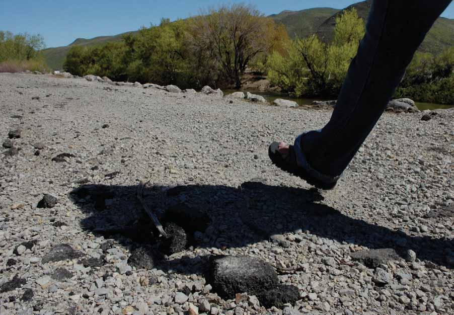
63 Leave no trace: Trail etiquette Every trail user has the responsibility to keep trails safe and enjoyable for all, and to protect our natural resources. Here are a few rules of the road. Keep an eye and an ear out for others on the trail. Cyclists yield to hikers, hikers and cyclists yield to horses. Always travel at a safe, controlled speed and alert other users as you approach from behind. Never approach or harass wildlife or domestic animals you may meet along the way. Keep pets on leashes and under control. Staying on the marked trail is an enormous help to the environment. Do not cut switchbacks or use other shortcuts. Leave the fl owers and plants for others to enjoy. PLEASE HELP PRESERVE THESE TRAILS FOR FUTURE GENERATIONS. Truckee Meadows Trails Your guide to trails in Reno, Sparks and Washoe County 61


64 Are you bear aware? When people are irresponsible with their food and garbage, bears can wind up in trouble. Bears naturally fear humans, but if they have access to human food sources they may become habituated, lose their fear of humans and become aggressive. PLEASE FOLLOW THESE RULES TO KEEP YOU AND NEVADA BEARS OUT OF HARM S WAY. When hiking, make noise Keep a clean camp or picnic area Use bear-proof storage containers and keep food cleaned up Never approach or feed a bear Keep a close watch on children Clean barbecue grills after use Never store food in your tent Do not leave food outside or on picnic tables WHAT SHOULD I DO IF I ENCOUNTER A BEAR? Although black bears rarely attack, they are powerful animals capable of injuring or killing humans. To date, no fatal or even serious bear attacks have been reported in Nevada. The steps below may be helpful if you encounter a bear. Give a bear plenty of room to pass If a bear approaches you don t run! Back away slowly, facing the bear. Remember, you cannot outrun a bear. Make yourself look bigger by waving your arms and yelling. Pick up children. Warning signs of a dangerous bear or impending attack include a steady glare, ears laid back, smacking of the jaws and stomping of the front feet. Source: Nevada Department of Wildlife Snake safety Nevada is home to fi ve snake species that can be dangerous to people and pets. The most common in Northern Nevada is the Great Basin Rattlesnake. Most rattlesnakes in Nevada are 1½ to 4 feet long and have broad, triangular shaped heads. The best way to avoid trouble with venomous snakes is to be aware of your surroundings and observe some safety rules. Avoid disturbing, removing or killing snakes. Most bites result from deliberate harassment of reptiles. Learn how to identify venomous reptiles. Use caution when hiking. Wear long pants, hiking boots and bring a walking stick. Determine safety from a distance before placing hands or feet atop or among rocks or crevices. Do not enter abandoned dwellings, caves or mines. After a hike, check under your car on hot days in case a reptile is seeking shade. Keep a close watch on children and teach them not to play with any snakes they fi nd. Keep pets on a leash. Source: Nevada Department of Wildlife 62 Truckee Meadows Trails Your guide to trails in Reno, Sparks and Washoe County


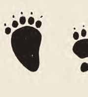
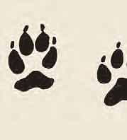

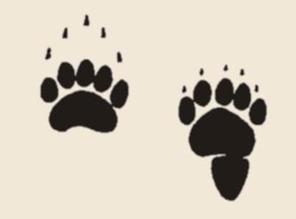
65 Animal tracks Black bear Coyote Jackrabbit Bobcat Domestic dog Mountain cottontail Truckee Meadows Trails Your guide to trails in Reno, Sparks and Washoe County 63


66 Animal tracks Cougar Deer Porcupine Raccoon Skunk 64 Truckee Meadows Trails Your guide to trails in Reno, Sparks and Washoe County
... 35 Evans Canyon Trail... 45-46 Evans Creek Trail... 47-49 Flume Trail (Bartley Ranch Regional Park).")
67 Index Anderson Park Trail Arboretum Trails Bitterbrush Trail Brown s Creek Trail Crystal Peak Nature Trail Deadman s Creek Trail Discovery Trail Dry Pond Trail... 9 Equestrian Trails (Washoe Lake State Park) Evans Canyon Trail Evans Creek Trail Flume Trail (Bartley Ranch Regional Park) Flume Trail (Lake Tahoe Nevada State Park) Galena Creek Trail (Callahan Park) Halo Trail Highland Loop Trail Huffaker Park Lookout Trail Hunter Lake Trail Hunter Creek Trail Incline Bike Paths Inner Loop Trail Interpretive Trail (Lockwood) Jones-Whites Creek Loop Trail Jumbo Grade Trail Keystone Canyon Trail Lakeview Loop Trail Little Washoe Lake Trail Lockwood Loop Trail Meadow Loop Trails Memorial Point Trail Mia Vista and South Park Loop Trail (Hidden Valley) Mira Loma Urban Trail Mount Rose Trail Nature Trail (Davis Creek Regional Park) Nature Trail (Galena Creek Regional Park) Nature Trail (Rancho San Rafael Regional Park) Ophir Creek Trail Oxbow Nature Study Area Trail Pah Rah Interpretive Trail Paradise Park Trail Pasture Loop Trail Perimeter Loop Trail Quail Run Trail Ranch Loop Trail Rancho Connector Slide Mountain Trail South Meadows Trails South Park Loop Trail Sparks Marina Loop Trail Sun Valley Regional Park Trails Swan Lake Nature Study Area Trail Tahoe Meadows Interpretive Trail Tahoe-Pyramid Bikeway Tahoe Rim Trail Thomas Creek Trail (Lower) Thomas Creek Trail (Upper)... 9 Tom Cooke Trail Tunnel Creek Road Trail Twin Peaks Trail Western Loop Trail Whites Creek Trail (Lower) Whites Creek Trail (Upper)... 9 Virginia Lake Loop Trail Vista-Campello Loop Trail


68 Funding for this guide was generously provided by a Federal Highway Administration Recreational Trails Program grant, along with support from our sponsors, Reno-Sparks Convention & Visitors Authority, Saint Mary s Regional Medical Center and Scheels.
Non-motorized Trail Plan & Proposal. August 8, 2014
 Town of Star Valley Ranch, Wyoming and the Star Valley Ranch Association in partnership with the USDA Forest Service, Bridger-Teton National Forest, Greys River Ranger District Non-motorized Trail Plan
Asheville & WNC Hikes
 Asheville & WNC Hikes Amazingly, we have 3,000+ miles of free public hiking trails near Asheville, including 1,600 miles in the Pisgah and Nantahala National Forests, 850 miles in Great Smokey Mountains
Piestewa Peak/Dreamy Draw Trail Guide
 Piestewa Peak/Dreamy Draw Trail Guide Trail #1A - Perl Charles Memorial Trail Length: 4.8 miles Elevation: 2,200 ft. - 1,340 ft. Difficulty: Moderate to difficult The Perl Charles trailhead is located
Stephens State Park Trails
 TRAILS OF ALLAMUCHY MOUNTAIN & STEPHENS STATE PARKS Allamuchy Mountain and Stephens State Parks contain 28 marked trails providing access to diverse landscapes for walking, hiking, biking, bird-watching,
playwinterpark.com Off The Beaten Path Hikes Hiking Recommendations for the Adventurous Hiker
 playwinterpark.com Off The Beaten Path Hikes Hiking Recommendations for the Adventurous Hiker Hike: Devil s Thumb (difficult) Length: 3.93 miles one-way Elevation: Trailhead 9609 Destination 12,236 Trailhead
Trail Phasing Plan. Note: Trails in the Clear Creek Canyon area (Segments will be finalized in the future to minimize wildlife impacts
 Note: Trails in the Clear Creek Canyon area (Segments 2 5 and a future JCOS connection) will be finalized in the future to minimize wildlife impacts Trail Phasing Plan P Parking 3 Easy Trail Intermediate
RECREATION AND RESORT PROJECTS
 RECREATION AND RESORT PROJECTS Coyote Moon Golf Clubhouse, Truckee, CA Dollar Point Pool and Tennis Club, Tahoe City, CA Donner Lake Boat Ramp, Truckee, CA Tahoe Swiss Village Beach and Shore Frontage,
Rogue Gorge (Mt. Stella) Roadless Area-- T30S R3E (primarily in portions of Sections 23, 26, 33, 34 & 35)
 Roadless Area-- T30S R3E (primarily in portions of Sections 23, 26, 33, 34 & 35)") Rogue Gorge (Mt. Stella) Roadless Area-- T30S R3E (primarily in portions of Sections 23, 26, 33, 34 & 35) Rogue River-Siskiyou National Forest--High Cascades Ranger District Upper, higher elevation trail
Rogue Gorge (Mt. Stella) Roadless Area-- T30S R3E (primarily in portions of Sections 23, 26, 33, 34 & 35) Rogue River-Siskiyou National Forest--High Cascades Ranger District Upper, higher elevation trail
GIFFORD PINCHOT NATIONAL FOREST
 GIFFORD PINCHOT NATIONAL FOREST 9341 Wright Meadow 93 Spencer Meadow Spencer Butte 4247' 30 30A 19 24 80 31C Lewis River Lower Falls 5 Quartz Creek 90 Taidnapam Falls Upper Falls 31 Spencer Peak 3861'
BROCHURE. APPLE HILL WOODS 118 +/- Acres Camino, California. Presented by Jim Copeland
 BROCHURE APPLE HILL WOODS 118 +/- Acres Camino, California Presented by Jim Copeland 1 The Property This 118 acre is a rare gem in the Sierra Nevada foothills. Covered with lush forestland and scattered
Geotourism Tahoe s 21 st Century Visitor Menu
 Geotourism Tahoe s 21 st Century Visitor Menu Geotourism is destination stewardship; tourism that sustains or enhances the unique geographical, cultural, aesthetic, heritage, environmental and local well
Trail Beginning Elevation: 7553 ft The Poison Creek Trailhead is located at the end of National Forest Road 646E (NF-646E).
.") West Mountain Trails Poison Creek Trail #134 Length: 2.9 miles (4.7 km) Difficulty Horseback: A good trail for the first time west mountain rider, some steep sections Hiking: Most Difficult USGS Maps:
West Mountain Trails Poison Creek Trail #134 Length: 2.9 miles (4.7 km) Difficulty Horseback: A good trail for the first time west mountain rider, some steep sections Hiking: Most Difficult USGS Maps:
CHAPTER 5. Chapter 5 Recreation Element
 CHAPTER 5 Recreation Element Chapter 5 Recreation Element The Recreation Element of the Meyers Area Plan is a supplement to the Recreation Element of the TRPA Regional Plan and the El Dorado County General
Northeast Quadrant Distinctive Features
 NORTHEAST QUADRANT Northeast Quadrant Distinctive Features LAND USE The Northeast Quadrant includes all the area within the planning area that is east of Interstate 5 and to the north of State Route 44.
Morgan Estates. Lassen County, CA. Proudly Offered By
 Morgan Estates Lassen County, CA Proudly Offered By 707 Merchant Street, Suite 100, Vacaville, Ca 95688 (707) 455-4444 Office (707) 455-0455 Fax info@caoutdoorproperties.com Introduction Looking North
Driving Time: 3 hours (allow extra time for stops)
") Scenic Byways loop This journey takes visitors through the eastern edge of Mt. Rainier National Park and along two of Washington s most beloved scenic byways, the Chinook Byway and the White Pass Scenic
Scenic Byways loop This journey takes visitors through the eastern edge of Mt. Rainier National Park and along two of Washington s most beloved scenic byways, the Chinook Byway and the White Pass Scenic
National Recreation Trail Update Form
 National Recreation Trail Update Form Introduction Thank you for taking the time to complete this form. Your assistance will help ensure that the National Recreation Trail (NRT) database is complete and
HIKING IN THE CANADIAN ROCKIES
 HIKING IN THE CANADIAN ROCKIES Distance Time Elevation y MORAINE LAKE TRAILS THE ROCKPILE 0.8 km (0.5 mi) 20 min 30 m (98 ft) Located adjacent to the Lodge, the short interpretive trail up the Rock Pile
Anderson Mt. Proposed Wilderness Additions to the Rogue-Umpqua Divide Wilderness-- T30S R3E (mostly) Sections 4 & 9, and T29S R3E Section 33
 Sections 4 & 9, and T29S R3E Section 33") Anderson Mt. Proposed Wilderness Additions to the Rogue-Umpqua Divide Wilderness-- T30S R3E (mostly) Sections 4 & 9, and T29S R3E Section 33 When the 35,701 acre Rogue-Umpqua Divide Wilderness was designated
Anderson Mt. Proposed Wilderness Additions to the Rogue-Umpqua Divide Wilderness-- T30S R3E (mostly) Sections 4 & 9, and T29S R3E Section 33 When the 35,701 acre Rogue-Umpqua Divide Wilderness was designated
Camping (Primitive) Camping (RV) Electrical Potable Water Grill Established Fire Pit Picnic Table
 Camping (RV) Electrical Potable Water Grill Established Fire Pit Picnic Table") Alden - 9th Road River Mile 777 Map: 38.20833, -98.32031 Managing Agency: Kansas Department of Wildlife, Parks & Tourism Nearest Community: Alden, Rice County Kansas Developed Amenities Provided Parking
Alden - 9th Road River Mile 777 Map: 38.20833, -98.32031 Managing Agency: Kansas Department of Wildlife, Parks & Tourism Nearest Community: Alden, Rice County Kansas Developed Amenities Provided Parking
This Passport: Revised October 20, 2017, EAM # Discovering the Trails of Penfield, NY
 This Passport: Revised October 20, 2017, EAM #161922 Discovering the Trails of Penfield, NY The Town of Penfield is fortunate to have a wide variety of natural resources which make for many unique and
BACK COUNTRY UNIT PREFERRED ALTERNATIVE
 BACK COUNTRY UNIT PREFERRED ALTERNATIVE San Francisco (118 mi) Carmel-By-The-Sea Carmel River Carmel Valley Road State Beach Private Property Point Lobos State Reserve Point Lobos Ranch RUSTIC CAMPING
National Recreation Trail Application for Designation
 National Recreation Trail Application for Designation Introduction Thank you for your interest in the National Recreation Trail (NRT) program. Completed NRT application packages must be submitted by December
San Luis Obispo. Bishop Peak Felsman Loop Eagle Rock Maino Open Space Poly Canyon Poly P Other Areas
 San Luis Obispo Bishop Peak Felsman Loop Eagle Rock Maino Open Space Poly Canyon Poly P Other Areas 1 JCT. ELEV. 72 400 00 0 FELSMAN LOOP GATE LOOP RIDGE 600 FENCE JCT. ELEV. 860 1000 1200 BISHOP PEAK
Hiking Las Vegas.com
 Hike: Mt. Wilson via First Creek Canyon route Trailhead: First Creek marked Distance: 10 miles up and back Elevation gain: 3,400 feet Elevation of Peak: 7,070 feet Time: 7 to 9 hours (up and back) Difficulty:
2017 Lake Tahoe Lakefront Report
 STONE CREEK LISTED BY KAREN BRUNO & JENNIE FAIRCHILD 201 Lake Tahoe Lakefront Report 660 N. LAKE BLVD. TAHOE CITY, CA 530.581.5300 EXCEPTIONAL PROPERTIES. EXTRAORDINARY LIVING. Oliver Luxury Real Estate
SEGMENT ASSESSMENT REPORT
 2017 SEGMENT ASSESSMENT REPORT SEGMENT 3: MT ROSE / TAHOE MEADOWS TO SPOONER SUMMIT REPORT SUMMARY This report is a compilation of information collected on the Tahoe Rim Trail during assessments performed
Hiking Trail Descriptions
 Hiking Trail Descriptions For ye shall go out with joy. And be led forth with peace. The mountains and the hills shall break forth before you in singing. And all the trees of the fields shall clap their
C E N T R A L C A T S K I L L S
 120 C E N T R A L C A T S K I L L S Central Catskills Once out of the southern parts of the Catskills, the Long Path enters the more well traveled and civilized regions. The trail joins the Devil s Path,
Route #1) Mt. of the Holy Cross - North Ridge
 Mt. of the Holy Cross - North Ridge") Climbing 14ers can be very dangerous, please read the Mountaineering Safety Page and make sure you have a map+compass and can use them effectively, without the help of electronic devices. Route #1) Mt.
Climbing 14ers can be very dangerous, please read the Mountaineering Safety Page and make sure you have a map+compass and can use them effectively, without the help of electronic devices. Route #1) Mt.
MOAB peopleforbikes.org/e-bikes
 emtb ADVENTURE MAPS MOAB peopleforbikes.org/e-bikes OVERVIEW Moab, Utah is a world-class mountain bike destination known for its vast, red sandstone landscapes nestled below the rising peaks of the La
Public Outreach and Online Survey Summary Report
 Public Outreach and Online Survey Summary Report To: Washoe County Regional Parks and Open Space From: Eric Hasty, Planner Wood Rodgers, Inc. Date: June 12, 2018 Re: WC Regional Parks and Open Space Master
Mother Lode Tour July 7 & 8, 2015
 Mother Lode Tour July 7 & 8, 2015 Tour leaves Orchard Creek at 8:30 AM July 7, 2015. Our exact route will be posted in late June so we don t have problems with road work. We will select roads that tend
Crystal Lake Area Trails
 Lake Area Trails Welcome to the Lake area of the Big Snowy Mountains! This island mountain range in central Montana features peaks reaching to 8,600 feet and long, high ridges from which vistas of the
This Passport: Revised October 20, 2017, EAM # Discovering the Trails of Webster, NY
 This Passport: Revised October 20, 2017, EAM #161923 Discovering the Trails of Webster, NY The Town of Webster invites you to explore and experience our diverse outdoor adventures! Here s your opportunity
City of Keller Parks and Facilities Inventory
 City of Keller Parks and Facilities Inventory April 2013 1. BEAR CREEK PARK 44 ACRES 1 Basketball Court with 2 goals 4 Drinking Fountains 1 Large Pavilion with 4 picnic tables, electricity and fireplace
Telluride-to-Moab Alternative Singletrack Options
 Telluride-to-Moab Alternative Singletrack Options Day 1 Day 1 Alternate 1: Galloping Goose to Deep Creek. 18.4 miles, ascent 3,530ft, descent 1,388ft. This is fun, flowey, moderate to intermediate singletrack
Suggested Day Hikes. Mount Greylock State Reservation 3, 4 1, 2. Take a Hike! Things to remember:
 Suggested Day Hikes Mount Greylock State Reservation Take a Hike! This guide offers suggested day hike routes in two parts: 1) Year-round Hikes and 2) Seasonal Hikes (late-may to Nov.1). Use this guide
2. Goals and Policies. The following are the adopted Parks and Trails Goals for Stillwater Township:
 D. PARKS AND TRAILS 1. Introduction Stillwater Township s population is relatively low, with most residents living on rural residences on large lots. The need for active park space has been minimal in
NDOT MAJOR PROJECTS AND INNOVATIVE DELIVERY 2017 NEVADA TRANSPORTATION CONFERENCE COLE MORTENSEN, PE ASST. CHIEF OF PROJECT MANAGEMENT
 NDOT MAJOR PROJECTS AND INNOVATIVE DELIVERY 2017 NEVADA TRANSPORTATION CONFERENCE COLE MORTENSEN, PE ASST. CHIEF OF PROJECT MANAGEMENT PM DIVISION RESPONSIBILITIES FHWA MAJOR PROJECTS TOTAL PROJECT COST
A Publication of Friends of Sleeping Bear Dunes
 A Publication of Friends of Sleeping Bear Dunes 2014, Friends of Sleeping Bear Dunes, P.O. Box 545, Empire, MI 49630 www.friendsofsleepingbear.org info@friendsofsleepingbear.org Learn more about the Friends
Royal Gorge Far Out Trail to Le Point
 Royal Gorge Far Out Trail to Le Point Direction to trailhead: From East Ridge Campground: Drive west from Canon City on US 50 to County Road 3A, the entrance road to the Royal Gorge Park. Turn left onto
Hiking Las Vegas.com
 Hike: Juniper Peak up and back Trailhead: Oak Creek Canyon marked Distance: 5.5 miles round trip Elevation gain: 2,200 feet Elevation peak: 6,109 feet Time: 4 to 5 hours - Up and back Difficulty: 3 Danger
BRYCE CANYON COUNTRY Boulder Mountain Scenic backways itinerary
 BRYCE CANYON COUNTRY Boulder Mountain Scenic backways itinerary Boulder Mountain Area The high plateaus of the Aquarius Plateau (Boulder Mountain), are heavily forested and covered in countless winding
Location: Height: Access: Distance: Elevation: Season: Difficulty: Lat/Long: Directions:
 Upper Eagle Falls Upper Eagle Falls (~20 ft.) is a short hike up from the roadside at the Eagle Falls picnic area. It is very difficult to get a parking spot here during the day, so it is recommended to
TAYLOR CANYON RANCH COLORADO - ROUTT COUNTY - STEAMBOAT SPRINGS
 TAYLOR CANYON RANCH COLORADO - ROUTT COUNTY - STEAMBOAT SPRINGS Tucked up against the steep valley shaped by Mt. Pau and rising to the Routt National Forest, Taylor Canyon Ranch is an easily accessible,
Weston County, Wyoming
 The Sweet 200-Acre Property Weston County, Wyoming A unique opportunity to own a little piece of the old West, where one can experience unparalleled scenery, adventure and history walk in the footsteps
Bureau of Land Management Public Lands Guide Northwest District
 Bureau of Land Management Public Lands Guide Northwest District NORTHWEST Fee Site Restrooms Picnic Sites Developed Campgrounds Farmington Field Office (505) 564-7600 Alien Run Mountain Bike Trail Angel
APPENDIX 19-II. Ontario Trail Network Trailheads EAST-WEST TIE TRANSMISSION PROJECT AMENDED ENVIRONMENTAL ASSESSMENT REPORT
 EAST-WEST TIE TRANSMISSION PROJECT AMENDED ENVIRONMENTAL ASSESSMENT REPORT APPENDIX 19-II Ontario Network heads Report. 1536607/2000/2219 Ontario Network heads in the n-commercial Land and Resource Use
AOTA ArtTrek Locations
 AOTA ArtTrek Locations ArtTrek is a summer-long Grand County, CO art adventure. Highlighted by snow-covered mountain vistas and rolling meadows threaded with sparkling streams and rivers, numerous sites
BROCHURE. Brandy Hill Ranch 300 Acres Placerville, California
 BROCHURE Brandy Hill Ranch 300 Acres Placerville, California Presented by Jim Copeland Shown by appointment 1 The Property This 300-acre ranch is a rare gem in the Sierra Nevada foothills and is located
Brinker Creek Ranch. Colorado - Routt County - Yampa
 Located at the base of the Flattops Range in the Steamboat/Vail corridor, Brinker Creek Ranch consists of 1,451 acres ideally suited for high country grazing and native grass hay production. Traditionally
Lava Mountain Trail Distance: Elevation Range: Trail Type: Difficulty: Season: Driving Distance: Driving Time: USGS Maps: Pros Cons
 Lava Mountain Trail Distance: 13.4 miles (including the side trip to North Star Lake) Elevation Range: 5900'-8330' Trail Type: singletrack Difficulty: moderate Season: late June-October Driving Distance:
PASSPORT. Discovering the Trails of Webster, NY
 PASSPORT to family wellness Discovering the Trails of Webster, NY Join the Friends of Webster Trails, Webster Health and Education Network, The Town of Webster and Wegmans to get moving more and enjoy
GOLDEN EARS PROVINCIAL PARK
 GOLDEN EARS PROVINCIAL PARK Trail Information as of October 10 th 2015 Do not underestimate the mountainous wilderness of Golden Ears Provincial Park. The combination of rugged terrain and rapidly changing
Skyline Drive Hogback Canon City
 Skyline Drive Hogback Canon City Direction to trailhead: From US 50, turn north onto 15th Street. At the traffic circle, continue north on 15th Street until it dead ends at Washington Street (about 1.5
U.S. National Forest Campground Guide
 U.S. National Forest Campground Guide Southwestern Region Arizona, New Mexico, Oklahoma and Texas National Forests and Grasslands in the Southwestern Region NF = National Forest NG = National Grassland
Route #2) Mt. Massive - Southwest Slopes
 Mt. Massive - Southwest Slopes") Route #2) Mt. Massive - Southwest Slopes Difficulty: Class 2 Ski: Advanced, D6 / R2 / III Exposure: Summit Elevation: Trailhead Elevation: Elevation Gain: Round-trip Length: Trailhead: County Sheriff:
Route #2) Mt. Massive - Southwest Slopes Difficulty: Class 2 Ski: Advanced, D6 / R2 / III Exposure: Summit Elevation: Trailhead Elevation: Elevation Gain: Round-trip Length: Trailhead: County Sheriff:
BROCHURE Sierra Foothills Ranch 55 Acres Pilot Hill, California. Presented by Jim Copeland
 BROCHURE Sierra Foothills Ranch 55 Acres Pilot Hill, California Presented by Jim Copeland 1 The Property This 55 acres is located midway between the historic California gold rush towns of Placerville and
Black Hill Regional Park, Little Seneca Lake
 Black Hill Regional Park, ittle Seneca ake ittle Seneca ake, in Black Hill Regional Park, is a reservoir created after a previous drought struck the Washington area. The park is under Maryland-National
TAHOE GETAWAY. Monday, October 1 through October 4, 2012
 TAHOE GETAWAY Monday, October 1 through October 4, 2012 COORDINATORS Sue Geisler --- Hiking Dennis Ratay --- Lodging Lodging is now filled. Waiting List: Anyone else interested in participating in the
ASRA 2018 Hike Schedule
 ASRA 2018 Hike Schedule Date/Day Destination Hike Info Meeting Info Leader Feb 10, Saturday Stagecoach and 9:00 at the Confluence kiosk. Manzanita trails Parking fee required. We ll hike along the trail
Southwest Quadrant Distinctive Features
 SOUTHWEST QUADRANT Southwest Quadrant Distinctive Features LAND USE The 31.17 square mile Southwest Quadrant includes all the area within the planning area west of I-5 and south of the Sacramento River.
Silver Lake Park An Environmental Jewel for the Citizens of Prince William County
 Silver Lake Park An Environmental Jewel for the Citizens of Prince William County The Prince William Park Authority Mission Statement states: The Prince William County Park Authority will create quality
Trails Technical Committee
 Trails Technical Committee Winter 2017 Draft Report Alignment Proposals for the Inyo National Forest and the Town of Mammoth Lakes Map ID #S18 February 08, 2017 Map ID #S18 Key Agreements As of February
Best Hikes on Orcas Island
 Published on San Juan Islands Washington Visitors Bureau Orcas Island Lopez Island Friday Harbor San Juan Island (https://www.visitsanjuans.com) Best Hikes on Orcas Island The Emerald Isle offers big trees,
Griffith Park Trail Run Trail Guide Click for
 The Griffith Park Trail Run by Hike- LosAngeles.com Griffith Park Trail Run Trail Guide Click for downloadable cell phone guide and map from EveryTrail. DISTANCE: 4.55 Miles ELEVATION: 1280' ELEVATION
Southern Utah University Hike Brochure
 Southern Utah University Hike Brochure Taylor Creek Trail Twenty minutes from Cedar City Red Hollow An hour and a half from Cedar City Fees: Entrance fee to Kolb Canyon Length: 5 miles round trip Length:
Ortiz River Ranch Pagosa Springs, Colorado
 Ortiz River Ranch Pagosa Springs, Colorado This ranch provides an exceptional opportunity to own a property with frontage on the San Juan and Navajo Rivers, lush irrigated pastures, and beautiful rolling
CORRIDOR CONTEXT & ANALYSIS DEFINING THE SETTING
 4 CORRIDOR CONTEXT & ANALYSIS DEFINING THE SETTING Public Safety Safety Emergency Turnouts Enforcement SR 28 Corridor Management SR 28 CMP 2013 Purpose & Need Partnerships 5 Benefit Areas Resource Plans
Wool Ranch 20 Acres 20 +/- acres Sunol, CA Alameda County
 Wool Ranch 20 Acres 20 +/- acres Sunol, CA Alameda County 707 Merchant Street Suite 100 Vacaville, CA 95688 707-455-4444 Office 707-455-0455 Fax californiaoutdoorproperties.com CalBRE# 01838294 Introduction
throu Booth Hill Green Belt
 s k r a p s l l u b m u r T Explore gh Geocaching throu Booth Hill Green Belt This was originally a concept to try and preserve some of the land in our town, without hurting the developers that are creating
Trailhead Ambassadors 2018 Latourell Falls: Alternative Hikes
 Trailhead Ambassadors 2018 Latourell Falls: Alternative Hikes General Note: The Historic Highway is closed from the Bridal Veil exit to its eastern end near Wyeth i.e., the Waterfall Alley section. The
Trail Etiquette. Hours of Operation. Trail Accessibility
 Trail Guide The Elmhurst Park District, with 28 parks and over 460 acres of land, offers nearly six miles of paved or asphalt park trails and maintains an additional 3.6 miles of trails within Elmhurst.
Discovering the Trails of Prince George s County
 Discovering the Trails of Prince George s County Happy Trails! Since 2005, Wegmans has been partnering with town and city recreation programs and park conservancy groups to encourage folks to get moving
Recreation News. Welcome. Chris Jackson. In this Issue: O S U C o l l e ge F o r e s t s
 Recreation News O S U C o l l e ge F o r e s t s In this Issue: Welcome New tree identification posts... New Arboretum Trails New Interpretive Signs Ridge Trail Seasonal Closures Leave No Trace reminder
S H A W A N G U N K R I D G E T R A I L
 214 Shawangunk Ridge Trail The Shawangunk Ridge Trail was originally conceived as a relocation of the Long Path from Harriman State Park to Minnewaska State Park. Now part of the Long Path system, the
PANORAMA VILLAGE 276 UNITS
 PANORAMA VILLAGE 276 UNITS 276 UNIT DEVELOPMENT OPPORTUNITY GIGI LANE RENO, NEVADA LOCATION The Property is located south of Dandini Boulevard in Reno, Washoe County, Nevada SIZE ± 15 Acres PRICE Submit
City of Oak Harbor Parks & Descriptions
 City of Oak Harbor Parks & Descriptions North West Section Koetje Park - NE 7 th Avenue (3.5 acres) Neighborhood and Community Park with playgrounds on one tot lot, one soccer/practice field, picnic tables,
Logan Canyon Hiking Trail Guide
 C a c h e V a l l e y V i s i t o r s B u r e a u Logan Canyon Hiking Trail Guide Monique Beeley Legend Trail Location Guide WASATCH CACHE NATIONAL FOREST WILDERNESS PAVED WATER TRAILHEAD 9 Logan River
Route Combo) Mt. Bierstadt - Bierstadt, Sawtooth, Evans
 Mt. Bierstadt - Bierstadt, Sawtooth, Evans") Climbing 14ers can be very dangerous, please read the Mountaineering Safety Page and make sure you have a map+compass and can use them effectively, without the help of electronic devices. Route Combo)
Climbing 14ers can be very dangerous, please read the Mountaineering Safety Page and make sure you have a map+compass and can use them effectively, without the help of electronic devices. Route Combo)
CRAZY HORSE TRAIL GUIDE
 CRAZY HORSE TRAIL GUIDE Abridged Version: July 2016 This is a short form of our interpretive trail guide for the Crazy Horse Trail. The full version of the guide has a more detailed description of the
beach. Make the ford and follow the trail out to the junction with Red Creek Tr in an open grassy area.
 Description: This is a moderate to slightly strenuous 22.8 mile backpack (add 2.6 miles if you do the packless out and back to the Lion s Head) that will have you exploring nearly every thing that is The
Acquisition in fee simple of approximately one-half acre of property on the shore of Spring Lake to expand the Lakeside Beach Park.
 Lakeside Beach TF00-136 $122,550.00 in fee simple of approximately one-half acre of property on the shore of Spring Lake to exp the Lakeside Beach. 2000 River Ravines TF00-150 $910,000.00 in fee simple
EXECUTIVE SUMMARY PROGRAM DEVELOPMENT REPORT PURPOSE EXISTING SETTING EXPANDING PARKLAND
 EXECUTIVE SUMMARY PROGRAM DEVELOPMENT REPORT PURPOSE As the culmination of the first phase of the master planning process, this Program Development Report creates the framework to develop the Calero County
CIEC 9 PEAKS AWARD SUPPLEMENT POSSIBLE ROUTES FOR THE 9 PEAKS AWARD TRIP
 CIEC 9 PEAKS AWARD SUPPLEMENT POSSIBLE ROUTES FOR THE 9 PEAKS AWARD TRIP As you plan your trip, be aware of 3 regulations in this wilderness: 1. Camp only in designated campsites. 2. No campfires allowed.
Frisco Historic Park. Prosit. Sustainability Activity. Insider's Tip. Published on Colorado.com (
 Published on Colorado.com (https://www.colorado.com) Summer in Historic Frisco 3 days More Itineraries Snuggled in the heart of Summit County, Frisco possesses the best of Colorado?s high country. From
Blue Ridge Hiking Club - First Quarter 2018 Hikes
 Blue Ridge Hiking Club - First Quarter 2018 Hikes Monday, Jan 1: Trout Lake to Manor House & Figure 8 Trail: Meet at Trout Lake parking lot, at 9:30. (1st exit left off Parkway just south of Cone Manor
TANAMERA MAJOR DEVELOPMENTS
 TANAMERA MAJOR DEVELOPMENTS AND PROJECTS IN DESIGN / UNDER CONSTRUCTION / BUILT IN THE RENO / SPARKS MARKET OF NEVADA 1996-2018 PREPARED BY TANAMERA JANUARY 3, 2019 HWY 395 NORTH RENO Amazon Petco Ashima
NORTHWEST SECTION CONTENTS: CLEVELAND PARK FOLWELL PARK RYAN LAKE PARK VICTORY PRAIRIE DOG PARK VICTORY PARK
 NORTHWEST SECTION CONTENTS: CLEVELAND PARK FOLWELL PARK RYAN LAKE PARK VICTORY PRAIRIE DOG PARK VICTORY PARK LUCY LANEY COMMUNITY SCHOOL N 33RD AVE N 33RD AVE SINGLE-FAMILY RESIDENTIAL MULTI-USE DIAMOND
To Wellness. To Wellness PASSPORT PASSPORT. Partners. Partners. Ashland County Health & Human Services 630 Sanborn Avenue, Ashland, WI
 Partners Ashland County Health & Human Services 630 Sanborn Avenue, Ashland, WI Ashland Bretting Center 320 4th Avenue W., Ashland, WI PASSPORT Bayfield County Health Department 117 E. 6th Street, Washburn,
Cumberland County Hiking Marathon Trail Descriptions
 Cumberland County Hiking Marathon Trail Descriptions 8/28/2017 Welcome to the 2017 Cumberland County Hiking Marathon. As you hike these trails you will enjoy a wide variety of terrain and geographical
PLACES TO WALK IN PORT COQUITLAM
 Places to Walk in Port Coquitlam Port Coquitlam is a walker s paradise, whether you re looking for a leisurely stroll or a challenging trek. Lace up your sneakers and try out these 18 walks submitted by
Nov. 19 th Public Workshop Summary
 On November 19 th, more than 60 community members attended an Open Space Matters workshop at the Linen Building in downtown Boise for over two hours. Participants learned about reserves, discussed the
LICENSE AGENT LIST Nevada License Agent List as of August 2015
 CHURCHILL COUNTY WESTERN REGION LICENSE AGENT LIST 010400 BIG 5 SPORTING GOODS #476 920 W WILLIAMS AVE STE 10, FALLON 89406 775-423-5515 YES 012000 WAL-MART #2453 2333 RENO HWY, FALLON 89406 775-428-1700
NAVAJO COMMUNITY PLAN
 NAVAJO COMMUNITY PLAN Prepared by the NAVAJO COMMUNITY PLANNERS and THE CITY OF SAN DIEGO City of San Diego Planning Department 202 C Street, MS 4A San Diego, CA 92101 Printed on recycled paper. This information,
NATIONAL ATV / UTV JAMBOREE RIDES
 NATIONAL ATV / UTV JAMBOREE RIDES Note: Rides range from Beginner to Advanced and will last from 2 to 3 hours or an entire day of riding. 1. DESERT RIDE (CLEAR LAKE BIRD REFUGE & LACE CURTAINS/LAVA TUBES)
General Overview: Acreage:
 General Overview: The Beaver Creek Ranch is located on Beaver Creek in Shell Wyoming, at the base of the western slope of the Big Horn Mountains, one of the west s most spectacular back drops. With an
Tiger Mountain State Forest:
 98 60 hikes within 60 miles: SEATTLE 20 Tiger Mountain State Forest: West Tiger Mountain Three Loop i KEY AT-A-GLANCE INFORMATION Length: 5.1 miles round-trip Configuration: Loop Difficulty: Moderate difficult
CAMP ROCK RANCH JACK KAVANAUGH RMABROKERS.COM
 CAMP ROCK RANCH JACK KAVANAUGH 303.909.1706 JACK@RMABROKERS.COM RMABROKERS.COM CAMP ROCK RANCH COLORADO - CLEAR CREEK COUNTY - UPPER BEAR CREEK ROAD, EVERGREEN The 162±-acre Camp Rock Ranch is surprisingly