I-15 CORRIDOR ALTERNATE ROUTE STUDY
|
|
|
- Jeffrey McGee
- 6 years ago
- Views:
Transcription


1 DRAFT TECHNICAL MEMORANDUM I-15 CORRIDOR ALTERNATE ROUTE STUDY CORRIDOR CONDITION INVENTORY APRIL 2017


2 DRAFT TECHNICAL MEMORANDUM I-15 Corridor Alternate Route Study Corridor Condition Inventory Prepared for I-15 Mobility Alliance April 2017
3 Contents Section CONTENTS Page Acronyms and Abbreviations... iii Introduction I-15 Mobility Alliance Alternate Route Study Report Purpose... 2 Alternate Route Delineation Framework Selection Criteria Alternative Segment Evaluation Stakeholder Input Alternate Route Condition Criteria Assessment Geometrics Capacity Safety Clusters of Fatal Crashes Drivability Vehicle Restrictions Amenities Cumulative Areas of Concern References Tables Table 2-1. Alternate Route Case Study Summary Matrix Table 2-2. Evaluation Criteria and Measures Table 2-3. Evaluation of Alternate Route Options Around the Virgin River Gorge and Moapa Valley Table 2-4. Evaluation of Alternate Route Options Around Mountain Pass Table 2-5. Evaluation of Alternate Route Options Around Cajon Pass Table 3-1. Alternate Route Condition Criteria Table 3-2. Assessment of Alternate Route Criteria by Corridor Segment Figures Figure 1-1. Study Area Figure 2-1. Segments with no Reasonable Local Alternate Routes Figure 2-2. Alternate Route Options Around the Virgin River Gorge and Moapa Valley Figure 2-3. Alternate Route Options Around Mountain Pass Figure 2-4. Alternate Route Options Around Cajon Pass I
4 CONTENTS Figure 2-5. I-15 Alternate Route Figure 3-1. I-15 Alternate Route Segments Figure 3-2. Map of Geometric Conditions Figure 3-3. Long, Straight, Flat Portion of US 93a Figure 3-4. US 6 at Murry Summit Figure 3-5. US 93 around Pahranagat Lake is Windy and Narrow Figure 3-6. US 95 in Nevada is Mostly 4-Lane Divided Highway Figure 3-7. US 95 in California Follows the Profile of the Terrain Figure 3-8. US 95 in California has a High Volume of Trucks and RVs, and Few Opportunities for Safe Passing Figure 3-9. No Storm Drains or Culverts on US 95 in California Allow Storm Water to Overtop the Roadway Figure Current Capacity Conditions Figure No Turn Lanes on NV 318 for the Kirch Wildlife Area Figure BNSF Railroad Crossing on US 95 north of I-40 Figure Railroad Crossing near McGill, Nevada Figure Railroad Crossing at Ely, Nevada Figure Railroad Crossing near Vidal, California Figure Fatal Crash Locations Figure Traffic Volumes on US93 Compared to Volumes on NV 318 and US 6 Alternate Route Figure Intersection of NV 318 and US 6 Figure Intersection of NV 318 and US 93 Figure Signs at Ely, Nevada Providing Options for Travel South to Las Vegas, Nevada Figure Back-up at the intersection of NV 319 with US 93 During the 2014 Moapa Flood I-15 Closure Figure Maximum Permissible Load on Bridges Figure Availability of Services Figure Cumulative Areas of Concern II
5 Acronyms and Abbreviations ADT AADT ATRI BTS CA Caltrans DOT ESRI FEMA FHWA FRA I ITS MPH MPO NDOT NHTSA NB NV SB US USDA USGS VPD average daily traffic average annual daily traffic American Transportation Research Institute Bureau of Transportation Statistics California California Department of Transportation Department of Transportation Environmental Systems Research Institute Federal Emergency Management Agency Federal Highway Administration Federal Railroad Administration Interstate Intelligent Transportation Systems miles per hour Metropolitan Planning Organization Nevada Department of Transportation National Highway Traffic Safety Administration northbound Nevada southbound United States United States Department of Agriculture United States Geological Survey vehicles per day III
6
 in California, Nevada, Arizona, and Utah, as well as key stakeholders along the")
7 SECTION 1 Introduction 1.1 I-15 Mobility Alliance The I-15 Mobility Alliance includes involvement from the Departments of Transportation (DOTs) in California, Nevada, Arizona, and Utah, as well as key stakeholders along the corridor. The Alliance transcends traditional transportation thinking by advancing innovation, long-range planning, investment, and implementation of multimodal systems; including not only increased mobility of people and goods through highways, freight rail, transit, and high-speed passenger rail, but also forwardlooking technologies for the transport of energy, data, and communications. The I-15 Corridor is a vital linkage in the economy not only of the western U.S., but of the entire nation. Projected increases in commodity flows from the western U.S. and Mexican ports, and population growth will result in expanded segments of I-15 experiencing severe congestion thus impeding commerce, hindering mobility, and degrading the quality-of-life of the people served by the corridor. Within the Alliance states, the I-15 Corridor runs from the southern terminus in San Diego, California to the Utah/Idaho border (Figure 1-1). This portion of the facility covers approximately 840 miles and runs through several major metropolitan areas including San Diego, the Inland Empire, Las Vegas, and Salt Lake City, and connects with the major interstates of I-5, I-8, I-10, and I-40 in California, and I-70, I-80, and I-84 in Utah. Figure 1-1. Study Area 1

8 SECTION 1 INTRODUCTION The mission of the Alliance and its members is to develop, in partnership with public and private sectors, a comprehensive, multimodal Master Plan for the I-15 Corridor, to prioritize projects and policies of interregional significance, to seek financial and other resources necessary for the implementation of the Master Plan, and to devise appropriate governance mechanisms for the ongoing efficient and effective construction, operations, and maintenance of the corridor on a more sustainable basis. 1.2 Alternate Route Study One of the elements of the mission of the I-15 Mobility Alliance is to maintain the efficient and effective operations of the I-15 Corridor. Through ongoing coordination efforts, it has become important to Alliance members to identify and understand operational constraints for alternative routes to I-15. In times of major incidents or natural disasters that may close or severely constrain use of I-15, drivers can make better and more informed choices on detour routing with advanced notice. In many cases, potential routing choices are limited due to the rural nature of the corridor, and these decisions may need to be made many miles in advance of the closure to avoid bottlenecks. The purpose of this study is to identify regional alternate routes to I-15, inventory the existing conditions of those routes, and document potential needs to meet minimum operating conditions. This effort will result in a clear set of alternate routes, and a prioritized list of improvements needed on those routes. 1.3 Report Purpose This technical memorandum documents the delineation of an I-15 alternate route, outlines corridor condition criteria, and summarizes current corridor conditions. This information will be used to inform any potentially beneficial improvements to the alternate route corridor to function in its role as a regional alternate route. 2

9 SECTION 2 Alternate Route Delineation 2.1 Framework The primary objective of this study is to identify and prioritize a set of improvements needed for a regional alternate route to I-15 connecting Salt Lake City, Las Vegas, Inland Empire, and San Diego. While many short detours exist to re-route local traffic in emergency situations, the I-15 alternate route delineation is intended to provide a regional corridor for longer-distance trips. Defining this corridor will assist the four Alliance states in strategizing regional detour routes and coordinating communication protocols in the event of a closure. A guiding resource in this delineation is the Federal Highway Administration s (FHWA) Alternate Route Handbook. The Handbook defines a regional alternate route as one that typically represents a high-speed, high-capacity facility that services through traffic, destined for some location (e.g., city) far downstream of the bottleneck location...[in order] to minimize travel time and delay anticipated on the local alternate route. Local alternate routes, which divert traffic a short distance, typically from one point (e.g., interchange or major intersection) to the next downstream point (FHWA 2006), serve the local community and travelers and are needed in conjunction with regional alternate routes. By removing regional traffic farther upstream of the closure, detour traffic can be dispersed among both the local and regional alternate routes, and increase the possibility of both functioning at an acceptable level of service. In addition to the Alternate Route Handbook several reports for local and regional alternate route studies were reviewed and their approaches incorporated into this study. The most helpful was the Nebraska Statewide Interstate and Expressway Alternate Route Study (URS 2007). This study presented an extensive review of alternate routing practices of other transportation departments, both state and metropolitan area, and includes a summary matrix of the methods and criteria upon which other agencies have based their selection of alternate routes, shown in Table 2-1. Implementation of an alternate route plan is a key traffic management strategy, serving to reduce demand upstream of an event site or bottleneck through the diversion of traffic from the mainline. The location and time of such events may be known in advance, or the event may happen at random with very little or no warning. Congestion-causing events, whether planned or unplanned, typically results in a reduction in roadway capacity and/or an increase in traffic demand. The following major cases of planned or unplanned event occurrences may necessitate the use of an alternate route plan: Traffic incidents, such as serious crashes or cargo spills that possibly include a hazardous material release, causing multi-lane or total road closure. Non-traffic incidents, such as major fires, industrial accidents, and bridge collapses, rendering sections of a roadway impassable. Emergencies, such as a severe weather event, acts of violence, or other major catastrophe, causing road closure and/or inducing a surge of traffic demand on evacuation routes that creates bottlenecks at capacity-restrained locations. Planned special events, such as a sporting/concert event or parade/festival, which creates an increase in travel demand and may require road closures to stage the event. Major roadway construction and maintenance, which may close or restrict a section of roadway. 3
10 SECTION 2 ALTERNATE ROUTE DELINEATION Table 2-1. Alternate Route Case Study Summary Matrix (URS 2007) Case Study Geometric Conditions Roadway Characteristics Vehicle Restrictions Safety & Other Capacity Constraints Criterion Impacts Route Operation Amenities Effectiveness Miscellaneous I-15 Synthesis I-95 Corridor Coalition Number of lanes; shoulder and lane width; divided roadway; pavement condition index; presence of problem drainage areas; grades Types and number of traffic control; speed limit; ADT; roadway classification; available turn lanes Height, weight, and width restrictions; bridge efficiency rating; truck turning radius Height, width and weight restrictions At-grade rail crossings (train frequency); visibility and sight distance; Level of truck-related crashes; drivability of alternate route Stay away from routes with current or potential construction activities School zones; major traffic generators; noise ordinances; residential areas Available ITS components; level of congestion introduced onto the alternate route; methods of conveying detour information; signing to guide motorists; availability of and space for temporary traffic control devices Highway lighting; access to freight terminals; availability of services (fuel, rest stops, food, lodging) Detour distance; travel time; level of service; prep work needed to get alternate route ready Keep alternative routes away from toll facilities Indiana DOT Shoulder and lane width; pavement, striping and signage condition; presence of problem drainage areas Height, weight and hazmat restrictions; turning radii at traffic signal; is the roadway a truck route? Number of left turns on alternate route; at-grade rail crossings (number and quality of warning devices); lift bridges; tunnels School zones; major traffic generators; noise ordinances Potential for coordination of traffic signals; availability of guidance along route; available ITS components Highway lighting availability Detour distance; travel time; level of service; prep work needed to get alternate route ready Objections from local political administrators; major events near route (concert, sporting event) New Jersey DOT Traffic Operations North Wisconsin DOT District 1 Wisconsin DOT District 3 Number of lanes; geometrics; pavement condition Pavement condition; number of lanes; is the roadway divided? Are there separate turn lanes? Capacity of route; types of traffic control; county roads vs. trunk highways State highways when possible; long truck route rules; speed limit; traffic control; capacity constraints Are roadways one way? speed limit; ADT; traffic control; roadway capacity Truck turning radius; height clearance; weight restrictions Height and weight restrictions At-grade rail crossings (train frequency); visibility and sight distance; water crossings Is there an identified bottleneck location? Bridge/ tunnel Schools or hospitals near route Don t pass through residential areas Who operates the traffic signals? Is police control of intersections required? Avoid routes with many signals, and many 90 degree turns Avoid routes that go in the opposite direction for more than one mile If necessary, will use two different routes for passenger and commercial traffic Consider options at all interchanges, and minimize the length of the route Route is analyzed based on the impact of peak-hour performance with diverted traffic Des Moines Area I-235 Project Pavement condition index; avoid roads with many curves and grade changes Height restrictions; bridge efficiency rating; truck turning radius At-grade rail crossings Schools near route Stay off other construction routes Arizona DOT CANAMEX Corridor (creation of a bypass route) Cambridge, Ontario Area (new or reconstruction of alternate alignments) Georgia DOT Annual pavement condition inventory Height, weight, and width restrictions Level of truck-related crashes Emergency response time to locations on route; at-grade rail crossings Potential positive economic impacts for nearby areas; negative impacts to residential areas Potential for disrupting neighborhoods; impacts on fish, wildlife, wetlands and vegetation Use trailblazer signage, temporary changeable message signs and adjusted traffic signal timing to move traffic more efficiently Access to freight terminals Accommodate alternate modes of transportation Various ITS components Length of alternate route; travel time; LOS Distance of travel; delays due to congestion Involves new or reconstruction of existing roadways to create a truck bypass Must be convincing to the public; simple methods are conveyed easier than complex methods Area engineers identify routes using local knowledge, and often ride routes to confirm; all routes are available via website NCHRP Synthesis 279 Number of lanes; pavement conditions; grades Number and type of controlled intersections Height, weight, and width restrictions Drivability of alternate route Proximity to residential developments; types of nearby land uses; any schools and hospitals Level of congestion introduced onto the alternate route; methods of conveying detour information Availability of services (fuel, rest stops, food, lodging) Proximity of the alternate route to the primary; ease of access; travel time Percentage of heavy vehicles to reroute; means of communicating with the public 4
11 SECTION 2 ALTERNATE ROUTE DELINEATION Case Study Geometric Conditions Roadway Characteristics Vehicle Restrictions Safety & Other Capacity Constraints Criterion Impacts Route Operation Amenities Effectiveness Miscellaneous Omaha - Council Bluffs Grades and notable hills; number of turns and curves; shoulder width; pavement condition Roadway classification; available turn lanes; speed limit Weight and height restrictions; turning radii issues At-grade rail crossings Nearby land uses; high traffic generators; any schools and hospitals Signing to guide motorists; availability of and space for temporary traffic control devices Service stations and other amenities; bus routes Travel distance prior to reentry; complexity of route Volume of heavy vehicles to reroute; planned construction on route; special events nearby Cleveland/ Lorain, Ohio (identification of ' deal breakers') Substandard roadway alignment or geometry; lack of shoulders Stay on limited access highways if possible; substantial change in speed limits At-grade rail crossings Nearby residential areas, schools or hospitals; areas of heavy pedestrian traffic Circuitous routes; no traffic signals to control or increase capacity for diverted traffic Roadways requiring resurfacing or reconstruction Dubuque and Clinton, Iowa Alternative Route Planning Is the route able to handle the increased volume? Stakeholders identify candidate routes through local knowledge and expertise 5


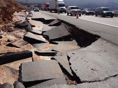
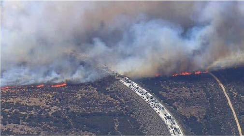
12 SECTION 2 ALTERNATE ROUTE DELINEATION The I-15 Corridor has experienced many of the above examples in the recent past, including the Moapa flood in southern Nevada, multiple closures of the Cajon Pass in California due to forest fires, traffic incidents, and inclement weather. Also, the segment between Las Vegas and southern California regularly experiences delay on weekends and holidays due to high volumes of recreational traffic. Detoured interregional traffic during the Moapa flood I-15 closure, Selection Criteria The first step in delineating an alternate route or routes to I-15 is to identify the characteristics of an ideal alternate route for I-15. FHWA s Alternate Route Handbook recommends that criteria should be chosen to benefit both motorists and the community at large, and indicates that alternate routes must: Be able to accommodate all vehicle types Be reasonably close to the primary route Have sufficient capacity to accommodate the traffic that is diverted Using this guidance, the primary characteristics used to define an alternate route to I-15 include the ability for the corridor(s) to: Maintain freight-supportive grades and bridges (able to accommodate all vehicle types) Have an acceptable free-flow travel time (reasonably close to the primary route) Currently have excess capacity (sufficient capacity to accommodate the traffic that is diverted) Limit community and environmental impacts (benefit the community at large) Support interstate travel The last element support interstate travel is an overriding key factor in that the defined alternate route, when used, may be accommodating major volumes of long-distance traffic. Identifying an existing corridor(s) that already supports interstate travel is more likely to meet the other four characteristics. Additionally, with transportation spending low and state budgets so constrained, conducting improvements to a route that currently experiences regular interstate travel supports a stronger regional transportation network, as opposed to improving highway segments that would otherwise be minimally used. Investment in the interregional alternate route serves:» Everyday interstate travel and commerce» Occasional alternate route Divert traffic well in advance of bottleneck Disperse traffic among regional and local alternate routes 6


13 2.3 Alternative Segment Evaluation SECTION 2 ALTERNATE ROUTE DELINEATION Areas along I-15 with no or limited reasonable local alternate routes have the highest need and were given extra consideration. These are segments are shown on Figure 2-1. Figure 2-1. Segments with no Reasonable Local Alternate Routes 7
14 SECTION 2 ALTERNATE ROUTE DELINEATION A set of reasonable alternate routes options were identified for each of these segments based on a regional perspective considering travel between the four major metropolitan areas of Salt Lake City, Las Vegas, Inland Empire, and San Diego. These options were evaluated based on the selection criteria noted in Section 2.2 of this report. The data and measures used for each criterion are listed in Table 2-2. Figures 2-2 through 2-4 show each of the three areas of highest need on I-15, with their associated alternate route options; and Tables 2-3 through 2-5 show the evaluation scores associated with each. Table 2-2. Evaluation Criteria and Measures Criteria Supports interstate travel Additional mileage Additional free-flow travel time Likelihood of excess capacity Community and environmental impacts Likelihood of freightsupportive grades and bridges Data Source and Measure A subjective measure based on the number of miles of US highways vs. less traveled regional or local roads. A scale of 1 to 3 was used, where 3 is most supportive. The additional out of direction miles between two points on I-15, as calculated using Google Maps. The data was normalized on a 3-point scale where 3 is the least number of miles compared to the other alternate routes. The additional free-flow travel time needed to travel between two points on I-15, as calculated using Google Maps. The travel times were taken at approximately 4:00 am on a weekday to capture travel times during minimal congestion. The data was normalized on a 3-point scale where 3 is the least free-flow travel time compared to the other alternate routes. A subjective measure on a scale of 1 to 3 was used, where 3 represents a 4-lane divided highway; and a 1 represents a rural highway that is narrow with stop conditions and very limited options for passing, or an urban roadway with peak period congestion. A subjective measure based on the type of roadway. It is assumed that a higher capacity roadway than currently passes through a community or environmentally sensitive areas would have a negative impact (low score of 1, on a scale of 1 to 3). A subjective measure based on the number of miles of US highways vs. less traveled regional or local roads, assuming that US highways already have freight-supportive grades & bridges. A scale of 1 to 3 was used, where 3 is most supportive. A common thread emerged the highest performing options in each of these areas included the US 93 corridor (with includes portions of US 93a, US 6, and NV 318) north of Las Vegas, and the US 95 corridor south of Las Vegas. By stitching together these highest performing options the backbone of the I-15 alternate route corridor emerged, with multiple options for connecting back to I-15 via other highways and interstates. With this framework in place, the interregional alternate route is defined as the US 95 corridor from I-10 (Blythe, CA) to I-515 (Las Vegas, NV), and the US 93 corridor from I-15 (Las Vegas, NV) to I-80 (Wells, NV) (Figure 2-5). Throughout this memo, these corridors may be referred to separately, as the broad characteristics along each segment of the route may differ. The several connectors are also defined, to make the linkages back to I-15 both along existing interstate corridors and major state highway connections. Some of these connectors may serve as a more localized alternate route in the case of an incident, however the primary corridor is intended to serve travelers that are bound for longer distances (generally traversing multiple states). This study effort will not focus on corridor conditions or needs for connector corridors. 8

15 Figure 2-2. Alternate Route Options Around the Virgin River Gorge and Moapa Valley SECTION 2 ALTERNATE ROUTE DELINEATION Table 2-3. Evaluation of Alternate Route Options Around the Virgin River Gorge and Moapa Valley Criteria 1a I-80 US93a US93/NV318 1b US6 US50 US93 1c UT56 NV319 US93 Supports interstate travel Additional mileage Additional free-flow travel time Likelihood of excess capacity Community and environmental impacts Freight-supportive grades and bridges Average

16 SECTION 2 ALTERNATE ROUTE DELINEATION Figure 2-3. Alternate Route Options Around Mountain Pass Table 2-4. Evaluation of Alternate Route Options Around Mountain Pass Criteria 2a US95 I-40 2b NV160 NV372 CA178 CA127 2c Kelso Rd - CA62 Supports interstate travel Additional mileage Additional free-flow travel time Likelihood of excess capacity Community and environmental impacts Freight-supportive grades and bridges Average

17 SECTION 2 ALTERNATE ROUTE DELINEATION Figure 2-4. Alternate Route Options Around Cajon Pass Table 2-5. Evaluation of Alternate Route Options Around Cajon Pass Criteria 3a US95 CA62 CA177 I-10 3b US95 CA78 CA111 I-8 3c CA247 CA62 I-10 I-215 Supports interstate travel Additional mileage Additional free-flow travel time Likelihood of excess capacity Community and environmental impacts Freight-supportive grades and bridges Average

18 SECTION 2 ALTERNATE ROUTE DELINEATION Figure 2-5. I-15 Alternate Route 12
19 2.4 Stakeholder Input SECTION 2 ALTERNATE ROUTE DELINEATION At the inception of this study effort, a series of in-person meetings and a webinar were held with I-15 Mobility Alliance Steering Committee members in major I-15 Corridor cities (San Diego, San Bernardino, Las Vegas, and Salt Lake City) to provide on an update on general Alliance activities, including this Alternate Route Study. DOT partners, along with representatives from the regional Metropolitan Planning Organizations (MPOs) and other Alliance partners attended. The primary interregional alternate route was presented, along with an overview of major corridor conditions. Most partners agreed that the route will not always be used in full, but that the delineation provides (1) a parallel route to I-15 that can handle interstate travel, and (2) a reliable detour, which is an important factor for the freight industry. Depending on the bottleneck location, using the defined alternate route may add 1-3 hours on to the trip, as opposed to potentially longer delays experienced during major closures. Ongoing coordination will be required among state DOTs to facilitate clear and effective communication in the case of an I-15 road closure. 13
20 SECTION 3 Alternate Route Condition 3.1 Criteria A set of physical roadway and operating condition factors that establishes the desired condition for an alternate route, accounting for use by both passenger vehicles and trucks, was developed to inform the data collection and inventory effort with the intent to highlight major corridor needs and deficiencies. Factors applicable to the I-15 alternate route were selected and modified from long lists of possible criteria presented in both the Alternate Route Handbook and the Nebraska Statewide Interstate and Expressway Alternate Route Study. Table 3-1 presents the major criteria categories selected for use in this study. Table 3-1. Alternate Route Condition Criteria Criteria Measures Desired Condition Geometrics Capacity Constraints Safety Vehicle Restrictions Amenities Number of lanes FEMA hazard areas and major waterbodies/waterways Types and number of traffic control Speed limit Available turn lanes At-grade railroad crossings 2 lanes with adequate locations for safe passing No problem drainage areas or roadway flooding No stop conditions 65 mph At all major traffic generators None at locations with greater than 100 trains per day, or where significant crashes occur 2015 traffic volumes (AADT) Less than 20,000 AADT on 2-lane sections Clusters of fatal crashes locations with 2 or more crashes Drivability Height, weight, and width restrictions Bridge efficiency rating Locations of food, fuel, restrooms, and hotel facilities Zero fatalities No intersections requiring a turn or highway change None Acceptable No gaps of 120 miles or more 3.2 Assessment The geometrics, capacity constraints, safety, vehicle restrictions, and amenities along the corridor were assessed to understand the functionality and constraints of the I-15 alternative route. This inventory was performed through a mapping analysis and field review to identify areas that do not meet the desired criteria described in Section 3.1. detect cumulative area concerns to improve the route(s) to the appropriate standard. A summary of the assessment of each criterion is presented in Table 3-2, organized by the following corridor segments shown on Figure 3-1: US 93a (I-80 US 93), US 93 (US 93a US 6), US 6 (US 93 NV 318), NV 318 (US 6 US 93), US 93 (NV I-15), US 95 (I CA), US 95 (NV - I-40), US 95 (I-40 - I- 10). 14

21 SECTION 3 ALTERNATE ROUTE CONDITION Figure 3-1. I-15 Alternate Route Segments 15
22 SECTION 3 ALTERNATE ROUTE CONDITION Table 3-2. Assessment of Alternate Route Criteria by Corridor Segment Criteria Measures US 93a (I-80 US 93) US 93 (US 93a US 6) US 6 (US 93 NV 318) NV 318 (US 6 US 93) US 93 (NV I-15) US 95 (I CA) US 95 (NV - I-40) US 95 (I-40 - I-10) Geometrics Number of lanes 2 lanes; mostly long, straight, flat with ample safe passing 2 lanes; mostly long, straight, flat with ample safe passing 2 lanes; Long grade with limited safe passing 2 lanes; mostly long, straight, flat with ample safe passing 2 lanes; mostly long, straight, flat with ample safe passing (except around Pahranagat Lake); grades 5-30 miles north of I-15 Mostly 4-lane divided 2 lanes with lots of curves and undulating profile limiting safe passing 2 lanes with lots of curves and undulating profile limiting safe passing FEMA hazard areas and major waterways No problem drainage areas or roadway flooding No problem drainage areas or roadway flooding No problem drainage areas or roadway flooding Prone to flooding around Nesbitt Lake (south of Hiko) No problem drainage areas or roadway flooding No problem drainage areas or roadway flooding Limited culverts; most drainage crosses highway Limited culverts; most drainage crosses highway Capacity Constraints Types and number of traffic control Predominant speed limit Available turn lanes Railroad crossings No stops 3 signals in Ely No stops 70 mph 70 mph (reduced speed through McGill, Ely) 55 mph Stop signs on NV 318: NB at US 6, and SB at US mph (reduced speed through Lund, Hiko) No stops No stops No stops 70 mph (reduced speed through Ash Springs, Alamo) 75 mph (reduced speed through Searchlight) 65 mph (reduced speed at BNSF crossing) Few to none Few to none Few to none Few to none Few to none Yes Few to none Few to none None 3 at-grade crossings; very few trains None None None None BNSF crossing just north of I-40; 84 trains per day Signals at I-40 and I-10 ramps. Stop signs at CA 62 (Vidal Junction) and Hobsonway (Blythe) 65 mph (reduced speed at Needles, Vidal Junction, Blythe) 1 at-grade crossing just south of CA 62; very few trains 2015 AADT Less than 11,200 vpd Less than 11,200 vpd Less than 11,200 vpd Less than 11,200 vpd Less than 11,200 vpd Less than 11,200 vpd Less than 11,200 vpd Less than 11,200 vpd Fatal crash locations None 1 location (in Ely) with 2 or more crashes None 1 location (south of Lund) with 2 or more crashes 1 location (near Pahranagat Lake) with 2 or more crashes 1 location (south of US 93) with 2 or more crashes None 1 location (north of Blythe) with 2 or more crashes Safety Drivability Easy Transition to US 93 does not require stop or direction change Transition at US 93/US 6 requires stop and/or direction change Transition at US 6/NV 318 requires stop and/or direction change Transition at NV 318/US 93 requires stop and/or direction change Easy Easy Easy Vehicle Restrictions Height, weight, and width restrictions Bridge efficiency rating None None None None None None None None Acceptable Acceptable Acceptable Acceptable Acceptable Acceptable Acceptable Acceptable Amenities Location of facilities West Wendover (food, gas, lodging) McGill (food, gas); Ely (food, gas, lodging) None Preston (food, gas, lodging) At NV 318 (food); Alamo (food, gas, lodging); at I-15 (food, gas) Searchlight and Cal-Nev- Ari (food, gas, lodging); Palm Gardens (gas, food) None Needles and Blythe (food, gas, lodging); Vidal Junction (gas, food) 16
23 3.2.1 Geometrics SECTION 3 ALTERNATE ROUTE CONDITION While a 4-lane, divided highway is ideal, the desired conditions for this alternate route are 2 lanes with adequate locations for safe passing, and no problem drainage areas or roadway flooding. Figure 3-2 indicates the key geometric conditions along the corridor. Most of US 93a, US 93, and NV 318 are 2-lanes with long stretches that are straight and flat, shown in Figure 3-3, providing ample opportunities for safe passing. US 6 is a 2-lane highway with approximately 10 miles of steep grades over Murry Summit, just south of Ely, Nevada which has limited opportunities for safe passing of slow moving vehicles (Figure 3-4). US 93 around Pahranagat Lake is windy and narrow (Figure 3-5), inhibiting passing. Most of US 95 in Nevada is a 4-lane divided highway (Figure 3-6) with a 75 mph speed limit. US 95 in California is a 2-lane highway that follows the profile of the terrain (Figure 3-7) and is somewhat windy, providing fewer opportunities to pass safely (Figure 3-8). For the most part there are no drainage or flooding issues on the alternate route segments in Nevada, with the exception of NV 318 around Nesbitt Lake. US 95 in California, as noted above, follows the contour of the surrounding terrain allowing storm water to overtop the roadway (Figure 3-9). 17

24 SECTION 3 ALTERNATE ROUTE CONDITION Figure 3-2. Map of Geometric Conditions 18


25 SECTION 3 ALTERNATE ROUTE CONDITION Figure 3-3. Long, Straight, Flat Portion of US 93a Figure 3-4. US 6 at Murry Summit 19


26 SECTION 3 ALTERNATE ROUTE CONDITION Figure 3-5. US 93 around Pahranagat Lake is Windy and Narrow Figure 3-6. US 95 in Nevada is Mostly 4-Lane Divided Highway 20


27 SECTION 3 ALTERNATE ROUTE CONDITION Figure 3-7. US 95 in California Follows the Profile of the Terrain Figure 3-8. US 95 in California has a High Volume of Trucks and RVs, and Few Opportunities for Safe Passing 21

28 SECTION 3 ALTERNATE ROUTE CONDITION Figure 3-9. No Storm Drains or Culverts on US 95 in California Allow Storm Water to Overtop the Roadway 3.3 Capacity The desired conditions to maximize the capacity of the I-15 alternate route include: No stop conditions 65 mph speed limit Three or more lanes in areas where the average annual daily traffic (AADT) exceeds 20,000 Available turn lanes at all major traffic generators with cross streets or driveways (especially in high-speed locations) No at-grade railroad crossings at locations with greater than 100 trains per day, or where significant crashes occur Most of the corridor has speed limits of 65 mph except where the speed limit slows through towns, and on the 4-lane divided highway stretch of US 95 in Nevada where the speed limit is mostly 75 mph. There are only a handful of stop signs and signals, noted on Figure 3-10, and many of those are also in towns. There are no segments of the corridor where the average annual daily traffic exceeds 20,000 vehicles per day (vpd). With the exception of US 95 in Nevada, there are almost no right or left turn lanes, which can cause delays at locations with high turn volumes, and contribute to rear-end crashes in high-speed locations. Figure 3-11 is an example of a turn-off to a recreation area on NV 318 that does not have right or left turn lanes. There is only one at-grade railroad crossing, located on US 95 north of I-40 (Figure 3-12), where a significant number of trains cross the corridor (84 per day from BNSF). In addition to the delay caused by the trains, the speed limit is also reduced to 20 mph due to the rough conditions crossing two sets of tracks. The other three railroads that cross the corridor at grade level have limited to no service, shown on Figures 3-13 through
29 SECTION 3 ALTERNATE ROUTE CONDITION Figure Current Capacity Conditions 23


30 SECTION 3 ALTERNATE ROUTE CONDITION Figure No Turn Lanes on NV 318 for the Kirch Wildlife Area Figure BNSF Railroad Crossing on US 95 north of I-40 24


31 SECTION 3 ALTERNATE ROUTE CONDITION Figure Railroad Crossing on US 93 near McGill, Nevada Figure Railroad Crossing on US 93 at Ely, Nevada 25
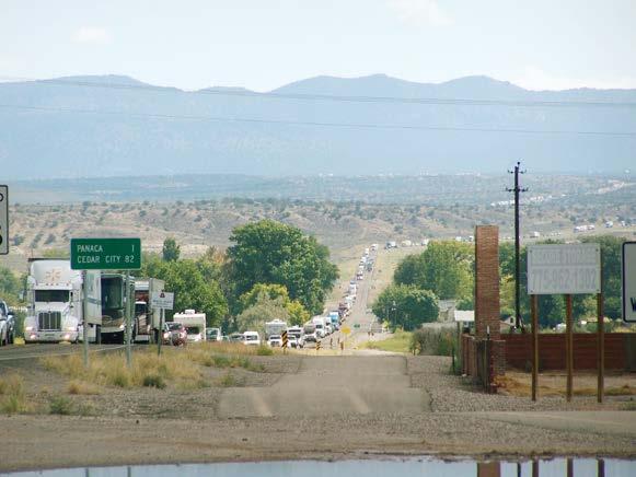
32 SECTION 3 ALTERNATE ROUTE CONDITION Figure Railroad Crossing on US 95 near Vidal, California 3.4 Safety Clusters of Fatal Crashes Crash information from the National Highway Traffic Safety Administration (NHTSA) (2015) was collected for the corridor to target safety concerns, as shown in Figure Nineteen fatal crashes are scattered throughout the corridor, with the largest cluster just south of the US 95/NV 165 intersection, south of metropolitan Las Vegas Drivability The Alternate Route Handbook states: Select routes that are easy for motorists to navigate and provide a sense of comfort (FHWA 2006). There are sections of the corridor where US 93 and US 95 are collocated with interstate freeways, but they are well-marked and easy to navigate. However, one location on the corridor has caused confusion for years. The most direct route between I-80 and I-15 follows the route recommended in this study, which deviates from US 93 at Ely, following instead US 6 to NV 318 and rejoining US 93 at Crystal Springs. The 2015 Annual Traffic Report indicates that this route carries over three times the volume of traffic than does the parallel US 93, as shown on Figure However, the through-movement follows the lower volume and less direct US 93. This is particularly problematic at the intersections of NV 318/US 6 (Figure 3-18) and NV 318/US 93 (Figure 3-19) where travelers following the proposed alternate route are required to either turn left, or stop and turn right (depending on direction of travel). Those not familiar with this route could get confused by the options and signage (see Figure 3-20) and may end up missing the turn. During a heavily congested detour condition traffic can dramatically back-up at these locations. This was evident during the I-15 closure in 2014 due to the Moapa flood. Southbound I-15 traffic was detoured at Cedar City, UT onto UT 56, to NV 319, and then to southbound US 93 back to I-15. Figure 3-21 shows the tremendous back-up that occurred at the intersection of NV 319 with US

33 SECTION 3 ALTERNATE ROUTE CONDITION Figure Fatal Crash Locations 27
34 SECTION 3 ALTERNATE ROUTE CONDITION Figure Traffic Volumes on US 93 Compared to Volumes on NV 318 and US 6 Alternate Route 28


35 SECTION 3 ALTERNATE ROUTE CONDITION Figure Intersection of NV 318 and US 6 Figure Intersection of NV 318 and US 93 29


36 SECTION 3 ALTERNATE ROUTE CONDITION Figure Signs at Ely, Nevada Providing Options for Travel South to Las Vegas, Nevada Figure Back-up at the intersection of NV 319 with US 93 During the 2014 Moapa Flood I-15 Closure 30

37 3.5 Vehicle Restrictions SECTION 3 ALTERNATE ROUTE CONDITION An assessment of bridge conditions was conducted to identify any issues along the desired alternate route with height, weight, or width restrictions, or with bridge efficiency ratings. Bridge data was collected from the National Bridge Inventory on 34 bridges identified along the corridor, and no structural deficiencies nor other restrictions were reported (Figure 3-22). Figure Maximum Permissible Load on Bridges 31

38 SECTION 3 ALTERNATE ROUTE CONDITION 3.6 Amenities Access to fuel, food, and hotel accommodations increases the feasibility of the corridor for use as an alternate route. Presence of these amenities is also a requirement for truck drivers, to meet hours-ofservice regulations. An aerial review of the corridor revealed food, gas, and hotel options along the corridor, shown in Figure Services are clustered predominately in West Wendover, Ely, Las Vegas (metropolitan area), and Searchlight in Nevada; and in Needles and Blythe, California. Sixteen food locations, 16 gas stations, and 12 lodging areas were identified. Food and lodging are typically paired together, while the gas stations are spread throughout the route. Only one span of the corridor, along NV 318, was identified as having a distance greater than 120 miles between gas stations. Figure Availability of Services 32

39 3.7 Cumulative Areas of Concern SECTION 3 ALTERNATE ROUTE CONDITION Figure 3-24 illustrates the cumulative areas of concern along the proposed alternate route. Figure Cumulative Areas of Concern 33
40
41 SECTION 4 References American Transportation Research Institute (ATRI) Travel Pattern Changes and Trucking Costs related to Interstate 15 Closure. Bureau of Transportation Statistics (BTS) National Bridge Inventory. Available at: BTS National Transportation Atlas Database. Available at: abase/index.html Caltrans. GIS Data. Caltrans GIS Data Library. Environmental Systems Research Institute (ESRI) TRINA Traffic Records Information Access. Available at: Federal Emergency Management Agency (FEMA) Mapping Information Platform, National Flood Hazard Layer. Federal Highway Administration (FHWA) Alternate Route Handbook. Available at: Federal Railroad Administration (FRA) Grade Crossing Inventory System. Available at: Nevada Department of Transportation (NDOT) ArcGIS Geodatabases. National Highway Traffic Safety Administration (NHTSA) Fatal Accident Reporting System. Available at: United States Department of Agriculture (USDA) Natural Resources Conservation Service GeoSpatial Data Gateway. United States Geological Survey (USGS) Hydrography. URS Nebraska Statewide Interstate and Expressway Alternate Route Study. Available at: 34
HIGHWAY RAIL GRADE CROSSING CONSOLIDATION PROGRAM
 HIGHWAY RAIL GRADE CROSSING CONSOLIDATION PROGRAM To decrease unnecessary train traffic exposure to life and property, promote public safety, and improve traffic conditions, the Texas Department of Transportation
4. Safety Concerns Potential Short and Medium-Term Improvements
 NH Route 104 Access Management Study Page 19 4. Safety Concerns Potential Short and Medium-Term Improvements Potential safety improvement strategies are listed by priority based on field observations by
2008 DEKALB COUNTY TRANSPORTATION PLAN (UPDATE)
") 2008 DEKALB COUNTY TRANSPORTATION PLAN (UPDATE) TABLE OF CONTENTS Introduction 1 Transportation Planning Activities 2 Identification of Problem Areas and Recommended Solutions 7 DeKalb County Projects
2008 DEKALB COUNTY TRANSPORTATION PLAN (UPDATE) TABLE OF CONTENTS Introduction 1 Transportation Planning Activities 2 Identification of Problem Areas and Recommended Solutions 7 DeKalb County Projects
5.1 Traffic and Transportation
 5.1 When it opens in 2009, the Bellevue Nickel Improvement Project will increase the number of vehicles able to travel through the study area, improve travel speeds, and improve safety by reducing the
FHWA P/N Guidelines. Corridor Relationship. Highway 22 Segment 1 - US 169 to CSAH 2 Relevance / Documentation of Need
 Highway 22 Segment 1 - US 169 to CSAH 2 Vehicle Mobility Congestion Intersection Congestion Existing Conditions - Based on Highway Capacity Manual methodology, corridor level of service is currently LOS
Research Report Agreement T4118, Task 24 HOV Action Plan HOV ACTION PLAN
 Research Report Agreement T4118, Task 24 HOV Action Plan HOV ACTION PLAN by John M. Ishimaru Senior Research Engineer Duane Wright Systems Analyst Programmer Mark E. Hallenbeck Director Jaime Kang Research
Memorandum. Roger Millar, Secretary of Transportation. Date: April 5, Interstate 90 Operations and Mercer Island Mobility
 Memorandum To: From: The Honorable Dow Constantine, King County Executive; The Honorable Ed Murray, City of Seattle Mayor; The Honorable Bruce Bassett, City of Mercer Island Mayor; The Honorable John Stokes,
2006 WEEKDAY TRAFFIC PROFILE. June 15, 2007
 June 15, 2007 Mr. Gary Stobb, P.E. Director of Planning/Operations Harris County Toll Road Authority 330 Meadowfern, Suite 200 Houston, TX 77067 Re: Westpark Tollway Value Pricing Analysis Dear Mr. Stobb:
Interstate 90 and Mercer Island Mobility Study APRIL Commissioned by. Prepared by
 Interstate 90 and Mercer Island Mobility Study APRIL 2017 Commissioned by Prepared by Interstate 90 and Mercer Island Mobility Study Commissioned by: Sound Transit Prepared by: April 2017 Contents Section
PURPOSE AND NEED (CONCURRENCE POINT 1) NEW CANADA ROAD PROJECT FROM STATE ROUTE 1 (U.S. HIGHWAY 70) TO U.S. INTERSTATE 40
 NEW CANADA ROAD PROJECT FROM STATE ROUTE 1 (U.S. HIGHWAY 70) TO U.S. INTERSTATE 40") PURPOSE AND NEED (CONCURRENCE POINT 1) NEW CANADA ROAD PROJECT FROM STATE ROUTE 1 (U.S. HIGHWAY 70) TO U.S. INTERSTATE 40 Project Description The primary purpose of this project is to improve the major
PURPOSE AND NEED (CONCURRENCE POINT 1) NEW CANADA ROAD PROJECT FROM STATE ROUTE 1 (U.S. HIGHWAY 70) TO U.S. INTERSTATE 40 Project Description The primary purpose of this project is to improve the major
FEDERAL HIGHWAY ADMINISTRATION NEVADA DEPARTMENT OF TRANSPORTATION ENVIRONMENTAL IMPACT STATEMENT RE-EVALUATION
 FEDERAL HIGHWAY ADMINISTRATION NEVADA DEPARTMENT OF TRANSPORTATION ENVIRONMENTAL IMPACT STATEMENT RE-EVALUATION Project Name: Boulder City/US 93 Corridor Study (Boulder City Bypass) Project Location: The
MEMORANDUM. Lynn Hayes LSA Associates, Inc.
 MEMORANDUM To: Lynn Hayes LSA Associates, Inc. Date: May 5, 217 From: Zawwar Saiyed, P.E., Senior Transportation Engineer Justin Tucker, Transportation Engineer I Linscott, Law & Greenspan, Engineers LLG
PREFACE. Service frequency; Hours of service; Service coverage; Passenger loading; Reliability, and Transit vs. auto travel time.
 PREFACE The Florida Department of Transportation (FDOT) has embarked upon a statewide evaluation of transit system performance. The outcome of this evaluation is a benchmark of transit performance that
HAMPTON ROADS CROSSINGS PATRIOTS CROSSING AND HRBT
 HRTPO Board Meeting March 21, 2013 Agenda ITEM #9: HAMPTON ROADS CROSSINGS PATRIOTS CROSSING AND HRBT Congestion at the Hampton Roads Bridge-Tunnel (HRBT) on I-64 has long been identified as a problem
Business Growth (as of mid 2002)
") Page 1 of 6 Planning FHWA > HEP > Planning > Econ Dev < Previous Contents Next > Business Growth (as of mid 2002) Data from two business directories was used to analyze the change in the number of businesses
Page 1 of 6 Planning FHWA > HEP > Planning > Econ Dev < Previous Contents Next > Business Growth (as of mid 2002) Data from two business directories was used to analyze the change in the number of businesses
At the time, the portion of the line through Eagle County remains wholly under the ownership of Union Pacific Railroad (UP).
.") Chapter 5 The Railroad Corridor as a Trail Corridor The intent of this chapter is to identify how the rail corridor, if available for lease or purchase in all or part, could be incorporated into the core
Chapter 5 The Railroad Corridor as a Trail Corridor The intent of this chapter is to identify how the rail corridor, if available for lease or purchase in all or part, could be incorporated into the core
According to FAA Advisory Circular 150/5060-5, Airport Capacity and Delay, the elements that affect airfield capacity include:
 4.1 INTRODUCTION The previous chapters have described the existing facilities and provided planning guidelines as well as a forecast of demand for aviation activity at North Perry Airport. The demand/capacity
Other Principle Arterials Minor Arterial Major Collector Minor Collector Local
 CHAPTER 10 TRANSPORTATION Introduction The system of public roads in East Pikeland Township is decidedly rural in character. Since the 1984, the road network has remained much the same, with the addition
Chapter 2: Entire US287 Corridor
 Chapter 2: Entire US287 Corridor The US287 Study Area spans four incorporated jurisdictions and two counties. Due to the length and density of infrastructure along the US287 Study Area, corridor-wide maps
Lake Erie Commerce Center Traffic Analysis
 LOCATION: East of NYS Route 5 at Bayview Road Town of Hamburg Erie County, New York PREPARED BY: Wendel Companies 140 John James Audubon Parkway Suite 200 Amherst, New York 14228 January 2012 i ii Table
A. CONCLUSIONS OF THE FGEIS
 Chapter 11: Traffic and Parking A. CONCLUSIONS OF THE FGEIS The FGEIS found that the Approved Plan will generate a substantial volume of vehicular and pedestrian activity, including an estimated 1,300
AGENDA ITEM I-6 Public Works
 AGENDA ITEM I-6 Public Works STAFF REPORT City Council Meeting Date: 8/6/2018 Staff Report Number: 18-150-CC Informational Item: Update on the Willow Road and highway 101 interchange construction, upcoming
Arlington County Board Meeting Project Briefing. October 20, 2015
 Arlington County Board Meeting Project Briefing October 20, 2015 Project Map 2 Project Context Only Interstate in the Country limited to HOV only traffic during rush hours Stoplight at the end of I-66
Appendix B Ultimate Airport Capacity and Delay Simulation Modeling Analysis
 Appendix B ULTIMATE AIRPORT CAPACITY & DELAY SIMULATION MODELING ANALYSIS B TABLE OF CONTENTS EXHIBITS TABLES B.1 Introduction... 1 B.2 Simulation Modeling Assumption and Methodology... 4 B.2.1 Runway
Overview of Highway 37 Project. Napa County Board of Supervisors December 20, 2016
 Overview of Highway 37 Project Napa County Board of Supervisors December 20, 2016 1 Project Location-Caltrans District 4 2 SR 37 Corridor Features 2 to 4 lane 21 mile corridor traversing Solano, Sonoma,
A. From I-68 in Monongalia County, West Virginia to SR 6119 in Fayette County, Pennsylvania 1
 Mon-Fayette Transportation Project A. From I-68 in Monongalia County, West Virginia to SR 6119 in Fayette County, Pennsylvania 1 The Mon/Fayette Transportation Project (MFTP) from I-68 in West Virginia
FEASIBILITY CRITERIA
 This chapter describes the methodology and criteria used to evaluate the feasibility of developing trails throughout the study areas. Land availability, habitat sensitivity, roadway crossings and on-street
Longmont to Boulder Regional Trail Jay Road Connection DRAFT FINAL REPORT
 Longmont to Boulder Regional Trail Jay Road Connection DRAFT FINAL REPORT December 2018 Project Summary Boulder County, Colorado, in partnership with the City of Boulder, is evaluating options for multi-use
IL 390 Station. Wood Dale Open House Summary 5/18/17
 Wood Dale Open House Summary 5/18/17 The first public open house for the Wood Dale Comprehensive Plan took place on May 18 th, 2017. The program was conducted as a fun community event and there were 216
Overview of Highway 37 Project. Novato Rotary November 4, 2016
 Overview of Highway 37 Project Novato Rotary November 4, 2016 Project Location-Caltrans District 4 SR 37 Corridor Features Two to Four lane 21 mile corridor traversing Solano, Sonoma, and Marin Counties.
ROUTE 20 CORRIDOR STUDY ---- Orange County, Virginia
 ROUTE 20 CORRIDOR STUDY ---- Orange County, Virginia Prepared by PARSONS Fairfax, Virginia on behalf of the: Rappahannock-Rapidan Regional Commission in cooperation with Orange County, Virginia Virginia
TRANSPORTATION ELEMENT
 Transportation TRANSPORTATION ELEMENT Data, Inventory, and Analysis Prepared by Contents 1.0 INTRODUCTION... 1 2.0 EXISTING CONDITIONS... 1 2.1 Roadways... 1 2.1.1 Jurisdiction... 1 2.1.2 Functional Classification...
1.2 Corridor History and Current Characteristics
 SECTION 1 Description and Background of Study Area 1.1 Introduction This preliminary engineering report was prepared for the Alaska Department of Transportation and Public Facilities (ADOT&PF). It is part
AGENDA ITEM 5 D WAKULLA ENVIRONMENTAL INSTITUTE (WEI) TRAIL FEASIBILITY STUDY
 TRAIL FEASIBILITY STUDY") March 19, 2018 AGENDA ITEM 5 D WAKULLA ENVIRONMENTAL INSTITUTE (WEI) TRAIL FEASIBILITY STUDY TYPE OF ITEM: Action STATEMENT OF ISSUE The Wakulla Environmental Institute (WEI) Trail is one of several trails
March 19, 2018 AGENDA ITEM 5 D WAKULLA ENVIRONMENTAL INSTITUTE (WEI) TRAIL FEASIBILITY STUDY TYPE OF ITEM: Action STATEMENT OF ISSUE The Wakulla Environmental Institute (WEI) Trail is one of several trails
McLean Citizens Association Transportation Committee Project Briefing
 McLean Citizens Association Transportation Committee Project Briefing November 10, 2015 Project Map 2 Project Context Only Interstate in the Country limited to HOV only traffic during rush hours Stoplight
Aviation, Rail, & Trucking 6-1
 6-1 This chapter describes the services, facilities, and condition of air, rail, and trucking as components of the transportation system. These three intermodal areas have an impact on the factors to be
A VISION FOR I-95. January 12, Delaware Department of Transportation
 A VISION FOR I-95 January 12, 2011 Delaware Department of Transportation The East Coast s Main Street Along with SR 1, the most significant highway in Delaware 29 miles to I ".', 2 Sponsoring / Cooperating
Airport Planning Area
 PLANNING AREA POLICIES l AIRPORT Airport Planning Area LOCATION AND CONTEXT The Airport Planning Area ( Airport area ) is a key part of Boise s economy and transportation network; it features a multi-purpose
Frequently Asked Questions on the Route 29 Solutions Improvements Projects
 Frequently Asked Questions on the Route 29 Solutions Improvements Projects Background What are the Route 29 Solutions improvement projects? These projects include the Route 29/250 Interchange ( Best Buy
Agenda: SASP SAC Meeting 3
 Agenda: SASP SAC Meeting 3 Date: 04/12/18 Public Involvement Plan Update Defining the System Recommended Classifications Discussion Break Review current system Outreach what we heard Proposed changes Classification
N4 Carrick-on-Shannon to Dromod Road Project. 2.1 Introduction
 Chapter 2 Need for the Scheme 2.1 Introduction The National Primary Route N4, Dublin to Sligo is a strategic corridor from Dublin to the northwest and border counties (See RCSR 101 in Volume 2). The National
2016 Regional Transportation Alternatives Program (TAP) Grant Application
 Grant Application") 2016 Regional Transportation Alternatives Program (TAP) Grant Application PROJECT TITLE: Yelm-Tenino Trail Extension Feasibility Study TRPC use only GENERAL PROJECT INFORMATION Agency or Organization City
2016 Regional Transportation Alternatives Program (TAP) Grant Application PROJECT TITLE: Yelm-Tenino Trail Extension Feasibility Study TRPC use only GENERAL PROJECT INFORMATION Agency or Organization City
State Route 8 Corridor. Northern Summit County s Path to Success
 State Route 8 Corridor Northern Summit County s Path to Success Construction Guide: 2008-2009 State Route 8 corridor work description State Route 8 Corridor 10 projects $262 million With its close proximity
Citrus Heights Creek Corridor Trail Project. Trail Advisory Group Meeting #3 July 8, 2013
 Citrus Heights Creek Corridor Trail Project Trail Advisory Group Meeting #3 July 8, 2013 Agenda Introductions Recap: Community Workshop, Survey Findings, and TAG Field Trip Community Concern Discussion:
Section 3-04 Cross Sectional Elements TABLE OF CONTENTS. INTRODUCTION...3 General...3 Exhibit 1-Cross-Sectional Elements...3
 Section 3-04 Cross Sectional Elements TABLE OF CONTENTS INTRODUCTION...3 General...3 Exhibit 1-Cross-Sectional Elements...3 CROSS-SECTIONAL ELEMENTS...3 Traveled Way...3 Shoulder...3 Surfacing Taper...3
A number of goals were identified during the initial work on this Big Lake Transportation Plan.
 C. Transportation General Background Information Big Lake s transportation system includes all the roads, paths and facilities that allow the movement of private vehicles, trains and planes, as well as
Treasure Island Supplemental Information Report Addendum
 1 1 1 1 0 1 0 1 0 1 Treasure Island Supplemental Information Report Addendum Introduction Purpose The purpose of this Supplemental Information Report (SIR) Addendum is to determine if the current land
Stage 2 ION: Light Rail Transit (LRT) from Kitchener to Cambridge
 from Kitchener to Cambridge") Stage 2 ION: Light Rail Transit (LRT) from Kitchener to Cambridge Public Consultation Centre (PCC) No. 3 Please Sign-in Cambridge City Hall November 21, 2017 2:00 to 8:00pm Preston Memorial Auditorium
Stage 2 ION: Light Rail Transit (LRT) from Kitchener to Cambridge Public Consultation Centre (PCC) No. 3 Please Sign-in Cambridge City Hall November 21, 2017 2:00 to 8:00pm Preston Memorial Auditorium
The Transportation Corridor Overlay District
 The Transportation Corridor Overlay District The Transportation Corridor Overlay District is a policy framework under which certain potentially beneficial development proposals may be considered, given
TRAFFIC CONTROL DEVICES MANUAL FOR WORK ZONES
 TRAFFIC CONTROL DEVICES MANUAL FOR WORK ZONES SUMMARY Work zone activities often create conditions on the travelled way that are hazardous particularly at night when the ability of motorists to see is
Draft Concept Alternatives Analysis for the Inaugural Airport Program September 2005
 Section 10 Preferred Inaugural Airport Concept 10.0 Introduction The Preferred Inaugural Airport Concept for SSA was developed by adding the preferred support/ancillary facilities selected in Section 9
Dusty Boots Unit II. Available Parcels and Informational Summary
 Dusty Boots Unit II Available Parcels and Informational Summary January 2008 Notice to Recipients Other Properties May be available upon Request. Please feel free to contact us with other requests as this
Regional Wayfinding Sign Strategy Thurston County Trails 2017
 Regional Wayfinding Sign Strategy Thurston County Trails 2017 Partners: Members and partnering organizations of the Thurston Thrives Community Design Action Team City of Lacey, City of Olympia, City of
SAMTRANS TITLE VI STANDARDS AND POLICIES
 SAMTRANS TITLE VI STANDARDS AND POLICIES Adopted March 13, 2013 Federal Title VI requirements of the Civil Rights Act of 1964 were recently updated by the Federal Transit Administration (FTA) and now require
MEMORANDUM. for HOV Monitoring on I-93 North and the Southeast Expressway, Boston Region MPO, November, 2011.
 MEMORANDUM Date: January 12, 2012 To: Congestion Management Process Files From: Seth Asante, Ryan Hicks, and Efi Pagitsas MPO Staff Re: Historical Trends: Travel Times and Vehicle Occupancy Levels for
Blueways: Rivers, lakes, or streams with public access for recreation that includes fishing, nature observation, and opportunities for boating.
 Parks, Open Space and Trails PRINCE WILLIAM COUNTY 2008 COMPREHENSIVE PLAN TRAILS PLAN CONTENTS The components of the trails plan are: Intent Definitions Goals, Policies, and Action Strategies Trails Map
HOV LANE PERFORMANCE MONITORING: 2000 REPORT EXECUTIVE SUMMARY
 Final Report Research Project Agreement No. T1803, Task 4 HOV Monitoring V HOV LANE PERFORMANCE MONITORING: 2000 REPORT EXECUTIVE SUMMARY by Jennifer Nee TRAC Research Engineer John Ishimaru TRAC Senior
The presentation was approximately 25 minutes The presentation is part of Working Group Meeting 3
 This is the presentation for the third Master Plan Update Working Group Meeting being conducted for the Ted Stevens Anchorage International Airport Master Plan Update. It was given on Thursday March 7
Route 141 and I-44 Design-Build Project Community Involvement Group. March 21, 2016
 Route 141 and I-44 Design-Build Project Community Involvement Group March 21, 2016 Purpose of CIG 1. Share information with major stakeholders 2. Keep stakeholders informed of the process 3. Reduce uncertainty
Environmental Assessment and Final Section 4(f)
") Environmental Assessment and Final Section 4(f) South Pleasant View Road, City of Madison County Highway M Reconstruction Cross Country Road to Prairie Hill Road Project ID 5992-09-81 September 16, 2016
Environmental Assessment and Final Section 4(f) South Pleasant View Road, City of Madison County Highway M Reconstruction Cross Country Road to Prairie Hill Road Project ID 5992-09-81 September 16, 2016
WELLINGTON $422 MILLION $614 MILLION $83 MILLION 22% SPEND $1.9 BILLION
 WELLINGTON WELLINGTON $1.9 BILLION FORECAST TOTAL WELLINGTON INVESTMENT The Wellington region s transport challenges are dominated by the region s concentration of population in the metropolitan cities,
MONTEREY REGIONAL AIRPORT MASTER PLAN TOPICAL QUESTIONS FROM THE PLANNING ADVISORY COMMITTEE AND TOPICAL RESPONSES
 MONTEREY REGIONAL AIRPORT MASTER PLAN TOPICAL QUESTIONS FROM THE PLANNING ADVISORY COMMITTEE AND TOPICAL RESPONSES Recurring topics emerged in some of the comments and questions raised by members of the
Guide for Permits Development adjacent to Provincial Highways
 Guide for Permits Development adjacent to Provincial Highways Engineering & Operations Division Highway Planning and Design Branch January 2019 TABLE OF CONTENTS 1 Introduction... 1 1.1 The Traffic and
US 380 FEASIBILITY STUDY
 US 380 FEASIBILITY STUDY Denton County CSJ(s): 0135-10-061, 0135-10-062 Public Meeting(s): January 15 & 22, 2019 WELCOME US 380 Denton County Feasibility Study DALLAS DISTRICT PUBLIC MEETING January 15
Appendix 6.1: Hazard Worksheet
 Appendix 6.1: Appendix 6.1: Ref. Condition, real or potential; that can cause injury, illness, etc. This is a prerequisite for an Airfield Hazards 1. Taxiway Geometry Direct access to runway from ramp
WELCOME to the Iditarod Dog Sledding Historic District (IDSHD) Workshop. January 11, Houston Middle School Houston, Alaska
 Workshop. January 11, Houston Middle School Houston, Alaska") WELCOME to the Iditarod Dog Sledding Historic District (IDSHD) Workshop January 11, 2012 Houston Middle School Houston, Alaska Workshop Purpose: Present/discuss proposed resolutions to comments received
WELCOME to the Iditarod Dog Sledding Historic District (IDSHD) Workshop January 11, 2012 Houston Middle School Houston, Alaska Workshop Purpose: Present/discuss proposed resolutions to comments received
5 Rail demand in Western Sydney
 5 Rail demand in Western Sydney About this chapter To better understand where new or enhanced rail services are needed, this chapter presents an overview of the existing and future demand on the rail network
NORTH FRASER PERIMETER ROAD WEST CORRIDOR DEFINITION STUDY
 NORTH FRASER PERIMETER ROAD WEST CORRIDOR DEFINITION STUDY MAY 2011 SW1132SWD NORTH FRASER PERIMETER ROAD WEST CORRIDOR DEFINITION STUDY TABLE OF CONTENTS 1.0 INTRODUCTION... 1 2.0 CURRENT TRAVEL PATTERNS
Section 106 Update Memo #1 Attachment D. Traffic Diversion & APE Expansion Methodology & Maps
 Section 106 Update Memo #1 Attachment D Traffic Diversion & APE Expansion Methodology & Maps I-65/I-70 North Split Interchange Reconstruction Project (Des. Nos. 1592385 & 1600808) Traffic Diversion and
C. APPROACH FOR IDENTIFYING THE BEST ROUTES FOR THE NEEDED TRANSMISSION SYSTEM IMPROVEMENTS
 C. APPROACH FOR IDENTIFYING THE BEST ROUTES FOR THE NEEDED TRANSMISSION SYSTEM IMPROVEMENTS CL&P s approach for identifying the best routes for the needed transmission system improvements included a determination
Welcome to the Illinois High-Speed Rail Chicago to St. Louis Construction Update Meeting. Today s meeting will provide an overview of the Program,
 Welcome to the Illinois High-Speed Rail Chicago to St. Louis Construction Update Meeting. Today s meeting will provide an overview of the Program, updates on construction to be held in this area, and how
Gold Coast. Rapid Transit. Chapter twelve Social impact. Chapter content
 Gold Coast Rapid Transit Chapter twelve Social impact Chapter content Social impact assessment process...235 Existing community profile...237 Consultation...238 Social impacts and mitigation strategies...239
Grade Crossings in High Speed Rail Corridors
 Grade Crossings in High Speed Rail Corridors 59 th ANNUAL ILLINOIS TRAFFIC ENGINEERING & SAFETY CONFERENCE October 21, 2010 Champaign, IL Michael E. Stead Rail Safety Section Illinois Commerce Commission
FNORTHWEST ARKANSAS WESTERN BELTWAY FEASIBILITY STUDY
 FNORTHWEST ARKANSAS WESTERN BELTWAY FEASIBILITY STUDY EXECUTIVE SUMMARY The 2030 Northwest Arkansas Regional Transportation Plan developed by the Northwest Arkansas Regional Planning Commission (NWARPC)
United States Department of the Interior National Park Service. Boundary Expansion Listed in National Register January 11, 2017
 NPS Form 10900-a (Rev. 8/2002) OMB No. 10240018 United States Department of the Interior National Park Service Boundary Expansion Listed in National Register January 11, 2017 National Register of Historic
The Baker/Carver Regional Trail is intended to
 Section V Design Guidance The Baker/Carver Regional Trail is intended to safely accommodate 183,000 annual visits, an array of non-motorized uses, a variety of skill levels, and persons with special needs.
CALIFORNIA HIGH-OCCUPANCY VEHICLE LANE DEGRADATION ACTION PLAN
 CALIFORNIA DEPARTMENT OF TRANSPORTATION CALIFORNIA HIGH-OCCUPANCY VEHICLE LANE DEGRADATION ACTION PLAN Prepared by Division of Traffic Operations Office of Traffic Management Submitted to Federal Highway
I-66 Inside the Beltway Feasibility Study
 I-66 Inside the Beltway Feasibility Study Feasibility Study Study Process Context Sensitive Dialogues Corridor Assessments / Data Collection Problem Statement Refinement Concept Development Concept Evaluation
This section evaluates the projected traffic operations and circulation impacts associated with the proposed upgrade and expansion of the LWRP.
 4.5 TRAFFIC AND CIRCULATION This section evaluates the projected traffic operations and circulation impacts associated with the proposed upgrade and expansion of the LWRP. 4.5.1 Environmental Setting Existing
The San Diego Region s Air Transportation Future
 The San Diego Region s Air Transportation Future June 22, 2006 1 Ryan N. Hall, Airport System Planner II San Diego County Regional Airport Authority Presentation Overview 1. The law 2. The ballot measure
Project Deliverable 4.1.3d Individual City Report - City of La Verne
 Pomona Valley ITS Project Project Deliverable 4.1.3d Individual City Report - City of La Verne Prepared by: April 19, 2002 099017000.1 Copyright 2002, Kimley-Horn and Associates, Inc TABLE OF CONTENTS
State Route 189 Project and Draft Resolution of Support. November 2014
 State Route 189 Project and Draft Resolution of Support November 2014 Corridor Location Image sources: ADOT Statewide and National Importance: CANAMEX Corridor Image source: FHWA Statewide and National
PERTH-ADELAIDE CORRIDOR STRATEGY
 INTRODUCTION The Royal Automobile Association of SA Inc (RAA), the State s principal advocate for motorists on a broad range of motoring-related issues, represents the views of more than 560,000 South
Georgetown-Lewes Rail/Trail Study. Rail/Trail Study: Cool Spring to Cape Henlopen State Park New Road Extension (House Resolution No.
 Georgetown-Lewes Rail/Trail Study Rail/Trail Study: Cool Spring to Cape Henlopen State Park New Road Extension (House Resolution No. 47) August 22, 2011 Presentation Outline Background Benefits Statewide
Introduction. The City of Elk Grove
 The Quiet Zone Application Process: Lessons Learned from Elk Grove, California 8/22/05 By: Dominic Spaethling, PB; Barry Lemke, PB; Gwen Owens, City of Elk Grove, CA Introduction The City of Elk Grove
Memorandum. To: From: cc: Date: November 7, Re: 1.0 Purpose and Organization of this Addendum. 2.0 Project Description
 Memorandum To: From: cc: Laura Prickett, Horizon Water and Environment Analette Ochoa and Wana Chiu, WRECO Parag Mehta, Kimley Horn Date: November 7, 2017 Re: Santa Cruz Route 1 Tier I and Tier II HOV
Pattullo Bridge Replacement Project
 Pattullo Bridge Overview This document will: Explain the challenges facing the Pattullo Bridge today Share how we propose moving forward translink.ca PAGE 1 History By Order of the Lieutenant Governor
Appendix 4.1 J. May 17, 2010 Memorandum from CTPS to the Inter Agency Coordinating Group
 Appendix 4.1 J May 17, 2010 Memorandum from CTPS to the Inter Agency Coordinating Group CTPS CENTRAL TRANSPORTATION PLANNING STAFF Staff to the Boston Region Metropolitan Planning Organization MEMORANDUM
Report to: Greater Cambridge Partnership Joint Assembly 18 January A10 Foxton level crossing bypass and travel hub
 Report to: Greater Cambridge Partnership Joint Assembly 18 January 2018 Lead officer: Chris Tunstall GCP Director of Transport A10 Foxton level crossing bypass and travel hub 1. Purpose 1.1 The list of
$244 $45 OVERVIEW National Land Transport Programme Bay of Plenty BAY OF PLENTY REGIONAL SUMMARY
 2015 18 National Land Transport Programme Bay of Plenty BAY OF PLENTY REGIONAL SUMMARY OVERVIEW Transport investment in the Bay of Plenty is targeted to support significant residential growth, new industrial
DISTRICT EXPRESS LANES ANNUAL REPORT FISCAL YEAR 2017 JULY 1, 2016 JUNE 30, FloridaExpressLanes.com
 DISTRICT EXPRESS LANES ANNUAL REPORT FISCAL YEAR 2017 JULY 1, 2016 JUNE 30, 2017 FloridaExpressLanes.com This page intentionally left blank. TABLE OF CONTENTS List of Figures... ii List of Tables.... ii
JOSLIN FIELD, MAGIC VALLEY REGIONAL AIRPORT DECEMBER 2012
 1. Introduction The Federal Aviation Administration (FAA) recommends that airport master plans be updated every 5 years or as necessary to keep them current. The Master Plan for Joslin Field, Magic Valley
WELCOME US 83 Public Meeting
 WELCOME US 83 Public Meeting From north of the Starr/Zapata County Line to Loma Blanca Road Thursday, June 8, 2017 Roma Middle School Lecture Hall Open House: 5 6 p.m. Presentation and Public Comment:
What We ve Learned About Highway Congestion
 What We ve Learned About Highway Congestion BY PRAVIN VARAIYA THERE ARE 26,000 SENSORS buried under the pavements of California freeways. Every thirty seconds, those sensors send data to our computers
Memorandum. Fund Allocation Fund Programming Policy/Legislation Plan/Study Capital Project Oversight/Delivery Budget/Finance Contract/Agreement Other:
 Memorandum Date: March 23, 2018 To: Transportation Authority Board From: Eric Cordoba Deputy Director Capital Projects Subject: 4/10/18 Board Meeting: San Francisco Freeway Corridor Management Study Update
Washington St. & Ash Coulee Dr./43 rd Ave Intersection Study
 430 IACC Building Fargo, ND 58105 Tel 701-231-8058 Fax 701-231-1945 www.ugpti.org www.atacenter.org Washington St. & Ash Coulee Dr./43 rd Ave Intersection Study Final Report April 2007 Prepared for: City
Chapter 4.0 Alternatives Analysis
 Chapter 4.0 Alternatives Analysis Chapter 1 accumulated the baseline of existing airport data, Chapter 2 presented the outlook for the future in terms of operational activity, Chapter 3 defined the facilities
EAST DON TRAIL ENVIRONMENTAL ASSESSMENT. Community Liaison Committee Meeting #3 July 15, :30 to 8:30 pm Flemingdon Park Library
 EAST DON TRAIL ENVIRONMENTAL ASSESSMENT Community Liaison Committee Meeting #3 July 15, 2013 6:30 to 8:30 pm Flemingdon Park Library Agenda 1. Welcome 2. Housekeeping and Updates a) Housekeeping b) CLC
Att. A, AI 46, 11/9/17
 Total s San Diego Metropolitan Transit System POLICY 42 PERFORMANCE MONITORING REPORT Page 1 of 6 Date: 11/8/17 OBJECTIVE Develop a Customer-Focused and Competitive System The following measures of productivity
Mount Pleasant (42, 43) and Connecticut Avenue (L1, L2) Lines Service Evaluation Study Open House Welcome! wmata.com/bus
 and Connecticut Avenue (L1, L2) Lines Service Evaluation Study Open House Welcome! wmata.com/bus") Mount Pleasant (42, 43) and Connecticut Avenue (L1, L2) Lines Service Evaluation Study Open House Welcome! Study Overview and Timeline Phase 1: Collect and Analyze Data Project Kickoff, September 2017
Mount Pleasant (42, 43) and Connecticut Avenue (L1, L2) Lines Service Evaluation Study Open House Welcome! Study Overview and Timeline Phase 1: Collect and Analyze Data Project Kickoff, September 2017