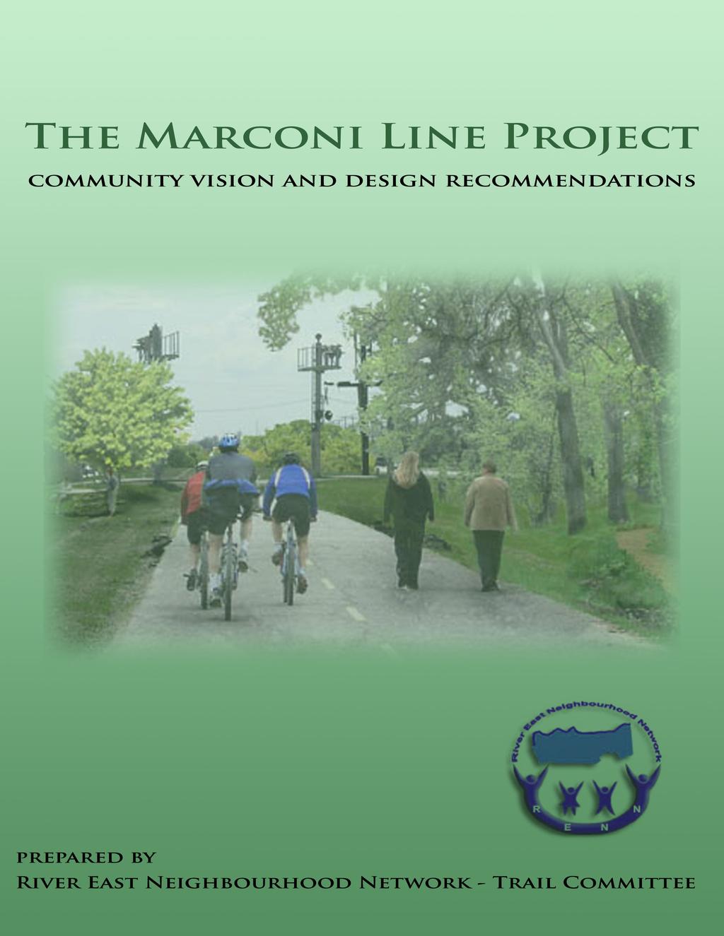
Background. The Marconi Line Project - Community Vision and Design Recommendations - 1-
|
|
|
- Lester Peters
- 6 years ago
- Views:
Transcription
1
2 Table of Contents Background Our Vision Benefits Marconi Line Project Recommendations Project Description Summary Detailed Project Description The Site User Groups Route Design Major Intersections Access Point and Connectivity Signage and Safety Amenities Maintenance Cost Considerations Summary Appendix A: Marconi - Downtown Connection.... Appendix B: Bird s Hill Park Acknowledgements
3 Background At it s meeting held on Sept. 27, 2006, Council approved the acquisition of 50.4 acres of C.P.R. Marconi Rail Right of Way between Gateway Road and Raleigh Street. Council also approved the development of a pathway on this property with construction to commence no later than the spring of 2008 and the matter be referred to the 2007 Capital Budget. This right-of-way is identified in the TransPlan 2010 report as a future consideration for transit. Furthermore, this report also recommends that properties such as this be protected for busways and/ or rail transit corridors. Plan Winnipeg 2020 Vision identifies this for a major street widening - and - a public transit roadway in a dedicated right-of-way all for consideration beyond On October 27, 2004 Council approved in principle the Civic Environment Committee report titled Sustainable Winnipeg: a Comprehensive Environmental Strategy. Two policy objectives in the report are as follows: The City of Winnipeg will work with citizens, local NGOs, the business community, and other levels of government to increase the degree of participation in active transportation through the expansion and implementation of facilities and infrastructure and towards the development of a comprehensive active transportation strategy for Winnipeg and The City of Winnipeg will strive to create a safe and extensive network of trails and greenways that link sites of ecological, historical, and cultural importance. Trails and greenways will be promoted to improve the connectivity between neighbourhoods. Active commuters, tourists, and citizens engaged in recreation, will use these trails. Therefore consistency in the trail network will be created and maintained. Plan Winnipeg 2020 Vision in dealing with Integrating Transportation states: establishing a city-wide bicycle and pedestrian pathway system which is segregated where practical and feasible from motorized traffic and which creates links between open spaces and major destinations. The River East Multi-use Trail Committee, which is coordinating other trail projects in the community, started work on this project at once. The Trail Committee is a sub-committee of the River East Neighbourhood Network (RENN). The River East Neighbourhood Network is a non-profit, legally incorporated entity comprised of a network of residents, businesses and agencies working together to enhance the lives of residents of the River East community by linking community stakeholders within the community. Public consultations were held to obtain input from user groups, city officials and community members. We have gathered and synthesized the knowledge, expertise and ideas of those present at the meetings and intend, with this report, to make a valuable contribution to the planning process. The report outlines the benefits of this project to our citizens and contains a description of pathway design requirements for establishing a cost estimate for budget & construction purposes. The Marconi Line Project - Community Vision and Design Recommendations - 1-
4 Our Vision The opportunity that this right-of-way provides must not be wasted. Today, we must recognize the need to adapt to a world that is becoming very different from what it once was. We have to identify very different challenges and plan to meet these challenges. In this regard, we are very pleased that Council has recognized pathway / trail development on this property as being a priority. A community amenity such as this will have a positive impact on community health and well being and will encourage people to participate in regular physical activity such as walking, cycling and running. We recognize that this development will become the backbone of the trail system in our community by connecting the Trans Canada Trail with other trails in our community and by being accessible to/from other community activity nodes such as work, play, and learning. In the long run, we will work to ensure that it connects to trails from the Forks to Birds Hill Park and Harbourview / Kilcona Park. As we drive on the road to the future, we are literally running out of gas. Alternative modes of transportation and multi use trail development are very important infrastructure components. Furthermore, healthy communities don t just happen. We are very excited about this project and the chance it provides for community organizations, user groups, city officials and Council to work together to develop a multi-use, showpiece development of which we can all be proud. The Marconi Line Project - Community Vision and Design Recommendations -2-
5 Benefits The following are the important benefits of this project. This multi-use trail: Will increase the physical activity and therefore the long-term health of residents by walking, running, cycling, and roller-blading. Moreover, it will have wheelchair, stroller, and bike-trailer access. Will improve community and resident connections by linking various parks, schools, community centers, churches, and businesses. Will appeal to a large cross-section of populations and socio-economic backgrounds from Elmwood to East St. Paul; it unites us all! Will have potential for enhanced community partnership and ownership with the added benefit of safety and security. Greater usage of this non-motorized-transportation corridor will encourage safety in numbers. Will add convenience for those already commuting to work in non-motorized vehicles. Will provide improved safety for cyclists. More folks may choose to leave motorized vehicles at home which will decrease the traffic, exhaust pollution, and wear and tear on our streets. Will have potential for increased tourism and business activity so Winnipeg is seen as having a clean and green approach to environmental preservation. This tourist attraction will be a key line of connectivity linking the Forks, downtown, and other areas of the city. Other cities (Montréal, Ottawa, Minneapolis) have extensive trail systems enabling tourists to explore in a fun and effective way. Will appeal to ecologically-minded young citizens who will be attracted to live and stay in Winnipeg. The multi-generations will create vibrancy within the city, while preserving the health and wellness of our population. Will increase property value in the immediate area. The Marconi Line Project - Community Vision and Design Recommendations - 3-
6 Marconi Line Project Recommendations Project Description Summary The Marconi Line Project presents the City of Winnipeg with an opportunity to connect all existing trails in the River East & Elmwood communities. The River East Trail Committee realizes that, once-built, this 7Km+ trail addition will become the backbone for all future trail development in our area. We also see the Marconi Line Project as a precedent-setting benchmark for subsequent trail development throughout the city. We feel that the establishment of a well-designed, well-funded trail in this key location will have ramifications that go far beyond the direct benefits incurred by the area s residents. As such, the fulfillment of the Marconi Line Project is a critical step in the future development of a comprehensive trail network for River East and the rest of Winnipeg and will be a showcase for our city s level of ingenuity and commitment to the environment. Detailed Project Description - The Site - The location and shape of the land in question give the Marconi Line characteristics which require special consideration. Relatively unique among Winnipeg s trails, it will be basically linear, it will not flood in the spring, it will run for a long distance (from the Perimeter to the edge of downtown) and it will connect hundreds of attractive destinations. As a result, it stands to be heavily used as a traveling route (as opposed to pure recreation) and will be especially valuable to young or inexperienced users who will see the Marconi Line as a safe, pleasant and legal alternative to the street or sidewalk. The Marconi Line Project - Community Vision and Design Recommendations -4-
 route and in improvements such as landscaping, sunshades, water fountains, benches, public art and historical plaques.")

7 -User Groups- Community consultation has identified two main groups whose needs differ and who stand to make this trail one of the most heavily used in the city. They are: 1. Pedestrians and joggers, who enjoy the calm and simplicity of traveling on foot. These users have a particular interest in the establishment of a more interesting (i.e. meandering) route and in improvements such as landscaping, sunshades, water fountains, benches, public art and historical plaques. 2. Relatively fast moving commuters and recreational users who would like to see the route streamlined as much as possible to reflect the benefits of their chosen form of transportation. These users require a smooth, well-maintained traveling surface and include mainly cyclists but also those on rollerblades, on skateboards and in wheelchairs. -Route Design- Due to the land s shape, proximity to traffic on both sides and to certain topographic features like ditches and wetlands, this project favours a trail that, for the most part, runs in the centre along the old rail line. There are a few areas that offer the space necessary for more deviation. In order to reflect the obvious features of the landscape and to address everyone s needs, RENN s trail committee recommends: - Installing one wide, direct, paved mainline running along the compacted bed of the former rail line, with off-shoots at popular, high-traffic access points ( Elmwood High School, Andersen Park Soccer Complex, Palliser Furniture, Civic Park, Bunn s Creek, Douglas Ave, etc.. (see Access Points and Connectivity) ). -That this mainline be complimented, where possible, by short pedestrian branches made of a suitable lowercost surface material such as bark-chips or limestone. The lower cost would allow for more design leeway; it s meandering structure will create a more interesting, natural-looking path that integrates seamlessly with the landscape. We suggest that these short paths will be most effective if they exist in order to provide approaches to riparian areas, point of interest markers and benches. (To comply with accessibility standards and ensure that this infrastructure is available to everybody, access to some essential amenties will necessarily be paved.) The Marconi Line Project - Community Vision and Design Recommendations -5-

8 Community consultation revealed that the width of the paved trail should ideally be 12. The width is crucial in order to be able to handle the expected user volume, 1 as there will be cyclists traveling in both directions who will be coming upon pedestrians and families with strollers, etc.. The surface type, asphalt, is necessary in order to make usage practical during inclement weather. Limestone is muddy and messy in the rain, and makes winter plowing much less effective/sustainable. Again, RENN-TC believes that this unprecedented public works project has the opportunity to set a precedent for the future and thereby improve the lives of all of Winnipeg s residents. We believe that a high quality surface type will ensure a high degree of usage. A high quality trail, experiencing a high degree of usage will be an advertisement for further development throughout the city. -Major Intersections- The new Marconi Pathway will be particularly special among Winnipeg s trails because of its highly visible location between two major streets. This creates unique challenges, but also offers unique opportunities. For example, if the route is properly designed to expedite the travel of cyclists, those drivers who are traveling parallel will note the amount of progress they are making, will note how fast it is and may soon begin to realize cycling s potential as a fun, healthy and safe alternative. From a usability standpoint, the most important features of the final design will be the major intersections and the many access points along the trail. At major intersections (Munroe, Springfield, etc ) improvements will have to be made to ensure safety and to ensure that users can quickly continue on their way. Cyclists are concerned about what they see as the likelihood that planners will route the path to the edges in order to make crossings near the lights at major intersections. This will slow cycling traffic down considerably, creating a less pleasant and efficient experience, especially considering Marconi s potential as a commuter cycling route. We believe that it is possible to find a solution where cyclists do not necessarily have to detour/dismount at major intersections, while still ensuring adequate flow of vehicle traffic. There are numerous examples from other cities where designers have accomplished this without unduly inconveniencing motorists. Some residents have noted that there is already a high potential for 1 The width of 12 was arrived at in consultation with the Winnipeg Trails Association, and draws on their experience working on similar projects. An example was given of the new Cloutier drive trail, a 9 wide recent addition to the trail system that is now experiencing heavier than expected usage. In Janice Lukes (Winnipeg Trails Coordinator WTA) view, the 9 width is not adequate to accommodate the heavy use it is now seeing. RENN-Trail committee recognizes that the Marconi Line trail will experience a much higher degree of usage, due to its location and convenience and that a 12 wide path would be best in order to accommodate two cyclists traveling in opposite directions and pedestrians/strollers/rollerbladers. WTA and RENN-TC are convinced that it is worth the added expense the easier and safer it is to use, the more people will use it. The Marconi Line Project - Community Vision and Design Recommendations -6-
9 accidents in the space between Raleigh and Gateway at major intersections. This problem is created by motorists attempting to squeeze into the available space in order to avoid risking a wait at two lights. If this is indeed the case, this problem will definitely need to be addressed with the advent of increased pedestrian/cyclist path crossings. Note that, currently, there are no North/South crossings on either the east side of Raleigh or the west side of Gateway (the location of the new path). Since some form of improvements are necessary, now is a good time to think creatively. A seemingly plausible solution is to reduce speed limits at the approaches to the pathway and post signs indicating the presence of a high volume crossing (similar to a school zone). This would greatly increase the safety of motorists, cyclists and pedestrians, with little impediment to vehicle movement. It would also allow trail users to proceed when they judge it to be safe rather than waiting to be instructed. This is especially pertinent during low-traffic volume situations, as they are prone to judge the safety and proceed regardless of signage. We are not qualified to outline and undertand all of the intricacies of this situation. However, we feel that residents and user groups have legitimate concerns and refreshing ideas. We want to ensure that the knowledge and experience of city engineers be used to their utmost to find a solution which takes these concerns and ideas seriously. - Access Points and Connectivity- It will be crucial to anticipate common points of access to ensure that people will know how to get to the trail safely and easily. Therefore, some careful thought should be given to improving certain east-west crossings on Raleigh and Gateway. For a transportation route of this type, the access points are less obvious than on an average road project. Pedestrians and cyclists are more likely to use informal trails and low volume streets coming from schools, community centres, shopping centres etc... Pedestrians and, especially, novice cyclists are not nearly as keen on using the existing major streets and are therefore less willing to join the trail at only those points. Note that people traveling on foot/bicycle are very likely to make their own way to the trail if it is inconvenient to use designated crossings. We should therefore anticipate and accommodate likely patterns of usage rather than trying to outright regulate them. In practice, this will mean a number of new crosswalks where the most direct/safe route from a common destination to the trail crosses either Raleigh or Gateway. We have prepared some diagrams that give an idea of the connectivity that can be expected. (Note that the beginning and end of the trail are also access points. Please see Appendix A - The Downtown- Marconi Connection and Appendix B - Bird s Hill Park.) The Marconi Line Project - Community Vision and Design Recommendations -7-

10 The Marconi Line Project - Community Vision and Design Recommendations -8-

11 The Marconi Line (South) connections for determining access points The Marconi Line Project - Community Vision and Design Recommendations -9-

12 The Marconi Line (North) connections for determining access points The Marconi Line Project - Community Vision and Design Recommendations -10-
 we recommend the installment of large scale route maps, showing the routes available throughout the city.")

13 -Signage and Safety- Well-placed signage is not just a safety issue. By pointing out connections of which people may not be aware, signs can also be a way of popularizing the trail system. We recommend informational signs, posted at reasonable intervals, which indicate the route layout and location of amenities and popular destinations. As other connections are made (i.e. to downtown, to Bird s Hill Park) we recommend the installment of large scale route maps, showing the routes available throughout the city. The pathway experience will also benefit from signs, in the form of Point of Interest markers, which illuminate historical events, places and people pertinent to the area. We also feel that painted lines/symbols on the trail surface itself are wise, in order to indicate and delineate the movement of fast-moving bicycles. -Amenities- While there do exist some areas of interest along the proposed route, and these should be highlighted, a sizeable portion of the route would benefit greatly from some landscaping improvements and should include: - Shelter from the sun and wind, in the form of pavilions, windrows of fast-growing trees - Benches and picnic tables, as well as public water fountains (such as those that exist along Wellington Crescent and the Assiniboine Park trail system) should be installed for comfort and rest. -Community gardens: gardening is Canada s number one hobby, and is especially popular in River East due to its high concentration of senior citizens. We believe that the creation of partnerships between the City of Winnipeg and interested groups in the area could create a valuable opportunity for those who would like to capitalize on underutilized portions of the route (especially in areas that are slated to become part of a future rapid transit development and for which permanent landscaping is therefore unwise). -Landscaping (Note: We believe that any landscaping should be done with respect to the local ecology and should encourage rather than discourage habitat creation for our native plant and animal species.) The Marconi Line Project - Community Vision and Design Recommendations -11-

14 -Maintenance- Cycling and walking, as forms of transportation, leave a relatively light footprint. This is reflected in the maintenance costs of the infrastructure they use. The more people are encouraged to use the Marconi trail as transportation the less are the expenses in road maintenance incurred by the City. That being said, a certain level of trail maintenance should be factored into the project budget to ensure that, for example, the route is plowed regularly to allow maximum use throughout the year. We are a winter city. Any plans we make should reflect our pride in not only being able to cope with the cold, but in being able to revel in it. Plowing would be limited to the asphalt-surfaced trail. - Cost Considerations - Community consultation also revealed strong opinions held by local residents regarding how this development should be funded: A lot of Manitobans are uncomfortable with the concept of using private funds to pay for public roads, highways and bridges. Since a comprehensive, well-maintained network of roads and highways is necessary for the economic growth, well-being and prosperity of everyone, they feel that it is the government s responsibility to use public funds to develop and maintain that network. Public consultation revealed that cycling/pedestrian trails should be treated with the same, if not higher, level of priority as on-road infrastructure. The benefits of a high quality motorized transportation network (such as added economic growth, connectivity, ease of transportation) are also seen in pedestrian/cycling infrastructure. Furthermore, the latter is sustainable, healthy, tourist-friendly, interesting and fun. There are many who see the Marconi Line trail as a long overdue and necessary infrastructure improvement for those who place a priority on environmentally sustainable transportation. Many feel that developments such as Marconi are precedent setting. Therefore, if the City of Winnipeg is to send a message that it supports ecologically sustainable route building it must be equally as supportive, not only in its policies and objectives, but also by providing adequate funds in its budgets. The Marconi Line Project - Community Vision and Design Recommendations -12-
15 Summary We recommend: Installing a wide, paved mainline capable of handling high-volumes of traffic and capable of accomodating users travelling at different speeds. Including many access points (including mid-block access points at residential streets) which allow users to connect as directly as possible to popular destinations. Intense scrutiny of major intersections to find a solution to facilitate the efficient passage of bicycles in the interest of creating a viable bicycle commuter route. Using signage for safety and to provide useful information to users (maps, points of interest). Installment of amenties such as benches and the usage of landscaping to enhance the pathway experience. Planting trees, erecting pavillions to provide shelter from the wind and sun. Setting aside the necessary funds to cover the cost of plowing in the winter. Improving the connection to downtown at the south end of the pathway. As soon as possible, continuing the route north to Bird s Hill Park. The Marconi Line Project - Community Vision and Design Recommendations -13-
 Downtown represents many things. It represents opportunities for leisure as well as work.")

16 Appendix A: Downtown - Marconi Connection The Marconi trail stands to provide many additional benefits to our community if improvements are made in its ability to connect to downtown. (see figure 1) Downtown represents many things. It represents opportunities for leisure as well as work. For a youngster wanting to visit the skatepark or an adult working in a downtown office, this is particularly important. Access to downtown also means access to extended trails systems like the Riverwalk and the new Winsmart trail. At some point in the near future, we foresee University of Manitoba students living in the Northeast being able to make a min. commute by bicycle. For the most part, the infrastructure is in place. Once one reaches the intersection of Mission and Archibald, there is a safe and pleasant route along low-volume residential streets parallel to Whittier Park all the way to Esplanade Riel and beyond. As it stands, anyone wishing to continue on southeast from the end of Marconi faces a circuitous and dangerous route. (see figure 2) CP Rail has been approached regarding the use of a small section of additional property in order to make a convenient connection. They have agreed to look at the proposal once plans for the purchase of the Marconi line have been finalized and funding for the pathway is in place. We urge planners and lawmakers to plan on improving this small section to coincide with the opening of the new Marconi trail. fig.1. A possible alternative. fig.2. Current best route continuation (inset with photos taken along route) The Marconi Line Project - Community Vision and Design Recommendations -14-


17 Appendix B: Bird s Hill Park The Marconi Line stands to make a very significant impact on tourism in the city and the health of its residents if it forms part of an uniterrupted cycling route from downtown to Bird s Hill Park. Cyclists currently enjoy using the many cycling trails that exist there, but unfortunately, unless they are willing to tackle the highway, they often arrive there by motorized vehicle with their bicycles in tow. We find this situation ironic and recognize in it an enormous opportunity to bring reknown to our city. We feel that a connection to Bird s Hill Park will also significantly increase ridership on the trail, and also bring economic benefits to merchants in our area. The Marconi Line Project - Community Vision and Design Recommendations -15-
18 Acknowledgements Photos Courtesy: Text by: Don English and Bike to the Future Janice Lukes and the Winnipeg Trails Association Manitoba Conservation website River East Neighbourhood Network - Trail Committee Marconi Greenway sign design by: Rachael Alpern and Anders Swanson Layout, maps and design by: Aerial Photos provided by: The Marconi Line Project - Community Vision and Design Recommendations -16-
Committee. Presentation Outline
 CW-33-15 11/9/2015 Community and Corporate Services Committee November 10, 2015 1 Presentation Outline Background Vision and Objectives Study Process and Timeline Public and Stakeholder Engagement Organization
City of Durango 5.8 FUNDING TRAILS DEVELOPMENT
 5.8 FUNDING TRAILS DEVELOPMENT The City has been successful in establishing dedicated local funding sources as well as applying for grants to develop the City s trail system, having received nearly $2.4
Blueways: Rivers, lakes, or streams with public access for recreation that includes fishing, nature observation, and opportunities for boating.
 Parks, Open Space and Trails PRINCE WILLIAM COUNTY 2008 COMPREHENSIVE PLAN TRAILS PLAN CONTENTS The components of the trails plan are: Intent Definitions Goals, Policies, and Action Strategies Trails Map
Georgetown-Lewes Rail/Trail Study. Rail/Trail Study: Cool Spring to Cape Henlopen State Park New Road Extension (House Resolution No.
 Georgetown-Lewes Rail/Trail Study Rail/Trail Study: Cool Spring to Cape Henlopen State Park New Road Extension (House Resolution No. 47) August 22, 2011 Presentation Outline Background Benefits Statewide
Public Open House. Chief Peguis Trail Project
 Public Open House Chief Peguis Trail Project CHIEF PEGUIS TRAIL OPEN HOUSE Welcome! Please browse the display boards Project Engineers and City of Winnipeg representatives are available to address your
FINCH HYDRO CORRIDOR TRAIL PROJECT
 FINCH HYDRO CORRIDOR TRAIL PROJECT Pharmacy Avenue to Birchmount Road January 29 th, 2018 L Amoreaux Community Centre (2000 McNicoll Avenue) 1 Purpose of Drop In Event The purpose of today s drop-in event
2016 Regional Transportation Alternatives Program (TAP) Grant Application
 Grant Application") 2016 Regional Transportation Alternatives Program (TAP) Grant Application PROJECT TITLE: Yelm-Tenino Trail Extension Feasibility Study TRPC use only GENERAL PROJECT INFORMATION Agency or Organization City
2016 Regional Transportation Alternatives Program (TAP) Grant Application PROJECT TITLE: Yelm-Tenino Trail Extension Feasibility Study TRPC use only GENERAL PROJECT INFORMATION Agency or Organization City
Lafourche Parish Government REQUEST FOR QUALIFICATIONS. Landscape Architectural Services
 Lafourche Parish Government REQUEST FOR QUALIFICATIONS Landscape Architectural Services Bayou Lafourche Parish Multi-Use Path Feasibility Study Phase 1 And Bayou Lafourche Parish Multi-Use Path Feasibility
Gold Coast. Rapid Transit. Chapter twelve Social impact. Chapter content
 Gold Coast Rapid Transit Chapter twelve Social impact Chapter content Social impact assessment process...235 Existing community profile...237 Consultation...238 Social impacts and mitigation strategies...239
A CASE FOR COMPLETING THE JORDAN RIVER PARKWAY: A
 A CASE FOR COMPLETING THE JORDAN RIVER PARKWAY: A safe crossing at 9000 South and 850 West Proposed 9000 South Underpass Parkway Timeline Parkway, Trail, and Tourism Facts Blueprint Jordan River 1971 1973
3. COLTA / HUGA CONNECTIONS - PRELIMINARY
 9 3. COLTA / HUGA CONNECTIONS - PRELIMINARY 3.1 COLTA The Chain of Lakes Trail Association (COLTA) trail, formerly identified as the Chester Spur Line, was completed and opened for use in June 2011. The
AGENDA ITEM 5 D WAKULLA ENVIRONMENTAL INSTITUTE (WEI) TRAIL FEASIBILITY STUDY
 TRAIL FEASIBILITY STUDY") March 19, 2018 AGENDA ITEM 5 D WAKULLA ENVIRONMENTAL INSTITUTE (WEI) TRAIL FEASIBILITY STUDY TYPE OF ITEM: Action STATEMENT OF ISSUE The Wakulla Environmental Institute (WEI) Trail is one of several trails
March 19, 2018 AGENDA ITEM 5 D WAKULLA ENVIRONMENTAL INSTITUTE (WEI) TRAIL FEASIBILITY STUDY TYPE OF ITEM: Action STATEMENT OF ISSUE The Wakulla Environmental Institute (WEI) Trail is one of several trails
IL 390 Station. Wood Dale Open House Summary 5/18/17
 Wood Dale Open House Summary 5/18/17 The first public open house for the Wood Dale Comprehensive Plan took place on May 18 th, 2017. The program was conducted as a fun community event and there were 216
Longmont to Boulder Regional Trail Jay Road Connection DRAFT FINAL REPORT
 Longmont to Boulder Regional Trail Jay Road Connection DRAFT FINAL REPORT December 2018 Project Summary Boulder County, Colorado, in partnership with the City of Boulder, is evaluating options for multi-use
Non-Motorized Transportation
 Non-Motorized Transportation Non-motorized facilities are important components to the transportation system. They provide an environmentally-friendly, low-cost mode of travel. Some of the facilities can
Chapter 6: POLICY AND PROCEDURE RECOMMENDATIONS
 Chapter 6 POLICY AND PROCEDURE RECOMMENDATIONS FOR SRRA Below are seven policy elements that should be considered for adoption by the Southwest Regional Recreation Authority of Virginia: 1. Develop strategies
Citrus Heights Creek Corridor Trail Project Trail Advisory Group Field Trip #2 September 11, :00 11:00 am Trellis Hall, Citrus Heights
 September 11, 2013 9:00 11:00 am Trellis Hall, Citrus Heights Project Overview The City of Citrus Heights is studying the feasibility of establishing a multi use trail system within the City s 26 miles
Appendix 3. Greenway Design Standards. The Whitemarsh Township Greenway Plan
 Appendix 3 Greenway Design Standards This chapter discusses two design standards for the greenway types discussed above. First, trail design standards are presented together with trailhead facilities and
BACKCOUNTRY TRAIL FLOOD REHABILITATION PROGRAM
 BACKCOUNTRY TRAIL FLOOD REHABILITATION PROGRAM Backcountry Trail Flood Rehabilitation A June 2013 Flood Recovery Program Summary In June 2013, parts of Southern Alberta were devastated from significant
K SIGNAGE & TRAFFIC CONTROL. Table of Contents
 Table of Contents K1. ACCOMMODATION OF TRAFFIC... 1 K2. MINIMUM CONSTRUCTION SIGNING... 1 K3. SUBDIVISION SIGNS... 2 K4. TRAFFIC CONTROL DEVICES... 2 K4.1 Traffic Signs Regulations... 2 K4.2 Materials...
4.0 Context for the Crossing Project
 4.0 Context for the Crossing Project This section provides background information about key features of the North Douglas Crossing project area, and opportunities and constraints. This information is important
University Region Non-Motorized Plan 2015
 Non-Motorized Transportation Non-motorized facilities are important components to the transportation system. They provide an environmentally-friendly, low-cost mode of travel. Some of the facilities can
Wilds. Headwaters. Lakes. Oxbows. Falls
 56 5 4 3 Wilds Headwaters Lakes Oxbows Falls 57 Zones It could be said the on-the-ground essence of this master plan appears within the next 6 pages of this report. As we learned in the preceding Cultural
Ground Transportation Strategy. Victoria Airport Authority
 Ground Transportation Strategy Victoria Airport Authority VAA Ground Transportation Strategy We live on an Island in the Pacific, but we are not isolated. A 15 minute flight from the Victoria International
STITCH TRANSFORMATIVE IDEA 3. SHORELINE STITCH. Re-connect the city to the waterfront and link the east and west Core Circle landscapes
 SHORE STITCH TRANSFORMATIVE IDEA 3. SHORELINE STITCH Re-connect the city to the waterfront and link the east and west Core Circle landscapes 126 LINE PUBLIC WORK 127 TRANSFORMATIVE IDEA 3. SHORELINE STITCH
Macleod Trail Corridor Study. Welcome. Macleod Trail Corridor Study Open House. Presentation of Proposed Design Concepts
 Macleod Trail Corridor Study Welcome Macleod Trail Corridor Study Open House Presentation of Proposed Design Concepts Study Purpose Develop a corridor plan for Macleod Trail that aligns with The City s:
4. Safety Concerns Potential Short and Medium-Term Improvements
 NH Route 104 Access Management Study Page 19 4. Safety Concerns Potential Short and Medium-Term Improvements Potential safety improvement strategies are listed by priority based on field observations by
Parkland County Municipal Development Plan Amendment Acheson Industrial Area Structure Plan
 Parkland County Municipal Development Plan Amendment Acheson Industrial Area Structure Plan New Plan Acheson Industrial Area Structure Plan Amendment Parkland County Municipal Development Plan Board Reference
FEASIBILITY CRITERIA
 This chapter describes the methodology and criteria used to evaluate the feasibility of developing trails throughout the study areas. Land availability, habitat sensitivity, roadway crossings and on-street
The Sunshine Coast is part of the global community and generates wealth through export, high-value industries and new investment.
 3.2 Strategic intent 3.2.1 Shaping growth an overview In 2031, the Sunshine Coast is renowned for its vibrant economy, ecological values, unique character and strong sense of community. It is Australia
LYNDHURST NEW URBAN DEVELOPMENT AREA STRUCTURE PLAN. Lyndhurst New Urban Development Area Structure Plan OUTCOMES AND PERFORMANCE STANDARDS
 APPENDIX 15.1-3 LYNDHURST NEW URBAN DEVELOPMENT AREA STRUCTURE PLAN Purpose of the Structure Plan Lyndhurst New Urban Development Area Structure Plan OUTCOMES AND PERFORMANCE STANDARDS LSP-P1 The District
Brampton, Ontario REQ. no.: PLANNING, DESIGN & DEVELOPMENT COMMITTEE
 ftorontoand REGION rv~ Conservation for The Living City May 22,2009 2I22V,5L CFN 42397 CLERK S DEPT. Mr. Peter Fay City Clerk, City of Brampton MAY 2 7 2008 2 Wellington Street West Brampton, Ontario REQ.
Welcome to the future of Terwillegar Park a Unique Natural Park
 Welcome to the future of Terwillegar Park a Unique Natural Park 1 Introduction The Terwillegar Park Concept Plan study will develop an overall concept plan, management objectives and development guidelines
Trail Use in the N.C. Museum of Art Park:
 Trail Use in the N.C. Museum of Art Park: New Connections, New Visitors Jacqueline MacDonald Gibson, PhD Daniel Rodriguez, PhD Taylor Dennerlein, MSEE, MCRP, EIT Jill Mead, MPH Evan Comen University of
Port Gamble Shoreline Area Conceptual Trail Proposal
 The North Kitsap Trails Association is pleased to be a partner to the Kitsap Forest and Bay Project and assist Kitsap County, Forterra, Olympic Property Group, Great Peninsula Conservancy and the Port
Mechanized River Valley Access Public Engagement Report. April 2015
 Mechanized River Valley Access Public Engagement Report April 2015 Table of Contents Background... 1 Stakeholder Consultation... 3 What We Heard... 4 Conclusion... 7 Background The North Saskatchewan River
1 PROJECT STATUS UPDATE 2 ND CONCESSION FROM BRISTOL ROAD TO DOANE ROAD TOWNS OF EAST GWILLIMBURY AND NEWMARKET
 Report No. 3 of the Regional Council Meeting of March 28, 2013 1 PROJECT STATUS UPDATE 2 ND CONCESSION FROM BRISTOL ROAD TO DOANE ROAD TOWNS OF EAST GWILLIMBURY AND NEWMARKET The recommends: 1. Receipt
TERMINAL DEVELOPMENT PLAN
 5.0 TERMINAL DEVELOPMENT PLAN 5.0 TERMINAL DEVELOPMENT PLAN Key points The development plan in the Master Plan includes the expansion of terminal infrastructure, creating integrated terminals for international,
Engagement Summary Report. Trans-Canada Highway 1 RW Bruhn Bridge Replacement Project. Community Engagement November 15, 2016 to January 15, 2017
 Trans-Canada Highway 1 RW Bruhn Bridge Replacement Project Community Engagement November 15, 2016 to January 15, 2017 Engagement Summary Report February 2017 Prepared by Kirk & Co. Consulting Ltd. Trans-Canada
Proposal to Redevelop Lower Kananaskis River-Barrier Lake. Bow Valley Provincial Park. Frequently Asked Questions
 Proposal to Redevelop Lower Kananaskis River-Barrier Lake Bow Valley Provincial Park Frequently Asked Questions What is being proposed? What are the details of the proposal? Where is the project area located?
Rating: 5.0 (scale of 1-10)
") 95 Community Trail System Groundcover: 2-metre paved path, 1- metre grass buffer on either side. Location: Fort St. John Ownership: City of Fort St. John Rating: 5.0 (scale of 1-10) Strategic value: Linear
95 Community Trail System Groundcover: 2-metre paved path, 1- metre grass buffer on either side. Location: Fort St. John Ownership: City of Fort St. John Rating: 5.0 (scale of 1-10) Strategic value: Linear
Airport Planning Area
 PLANNING AREA POLICIES l AIRPORT Airport Planning Area LOCATION AND CONTEXT The Airport Planning Area ( Airport area ) is a key part of Boise s economy and transportation network; it features a multi-purpose
China Creek North Park Upgrades and Glen Pump Station. Park Board Committee Meeting Monday, July 10, 2017
 China Creek North Park Upgrades and Glen Pump Station Park Board Committee Meeting Monday, July 10, 2017 Purpose The purpose of this presentation is to: Share the results of the public engagement processes;
Those with Interest in the City of Cambridge Trail System
 Community Services Department City Hall 50 Dickson Street, P.O. Box 669 Cambridge ON N1R 5W8 Tel: 519-740-4681 July 20, 2010 To: Re: Those with Interest in the City of Cambridge Trail System City of Cambridge
CORNWALL WATERFRONT PLAN 2007
 CANAL LANDS CANAL LANDS Page 58 Introduction This chapter details areas of possible development or redevelopment, and lands to be protected from any form of development in the Canal Lands area. As outlined
River First Initiative and Waterworks Park
 River First Initiative and Waterworks Park The RiverFIRST proposal is critical to the creation of a larger regional parks and trails network, as well as ecological and infrastructure system. When realized,
Next Generation Cycleway Design. Improving connectivity and cycling behaviours through design
 Next Generation Cycleway Design Improving connectivity and cycling behaviours through design Safe segregation between Place Users to offer improved safety and a defined space for each user group Elevated
Regional Wayfinding Sign Strategy Thurston County Trails 2017
 Regional Wayfinding Sign Strategy Thurston County Trails 2017 Partners: Members and partnering organizations of the Thurston Thrives Community Design Action Team City of Lacey, City of Olympia, City of
Bloor Street West Rezoning Application for a Temporary Use By-law Final Report
 STAFF REPORT ACTION REQUIRED 3741 3751 Bloor Street West Rezoning Application for a Temporary Use By-law Final Report Date: June 12, 2007 To: From: Wards: Reference Number: Etobicoke York Community Council
A link to heritage by connecting the community to its history.
 In March 2015 the Board of Sentiers Chelsea Trails asked Chelsea Council to explore the feasibility of converting the winter rail corridor trail into a 4 season, non-motorized, multi-purpose trail. To
This report recommends that Council approve concept plan 021-CP-001-B (see Attachment 1), for detailed design and delivery this financial year.
, for detailed design and delivery this financial year.") FPOL1711-9 HILTON TOWN CENTRE PROJECT SCOPE Meeting Date: 0 Responsible Officer: Manager Infrastructure Engineering Decision Making Authority: Council Agenda Attachments: 1. Concept Plan no 021-CP-001-B
FPOL1711-9 HILTON TOWN CENTRE PROJECT SCOPE Meeting Date: 0 Responsible Officer: Manager Infrastructure Engineering Decision Making Authority: Council Agenda Attachments: 1. Concept Plan no 021-CP-001-B
10/25/2013. What is the SCORP?! 2013 Local Government Survey 2013 Statewide Public Survey Advisory Group Priority Areas Your Suggestions!
 COLORADO OUTDOOR RECREATION TRENDS RESULTS FROM THE SCORP AND STATEWIDE Colorado Outdoor Recreation Resource Partnership September 2013 PRESENTATION What is the SCORP?! 2013 Local Government Survey 2013
Other Principle Arterials Minor Arterial Major Collector Minor Collector Local
 CHAPTER 10 TRANSPORTATION Introduction The system of public roads in East Pikeland Township is decidedly rural in character. Since the 1984, the road network has remained much the same, with the addition
Proposal to Redevelop Lower Kananaskis River-Barrier Lake. Bow Valley Provincial Park
 Frequently Asked Questions Proposal to Redevelop Lower Kananaskis River-Barrier Lake Bow Valley Provincial Park Frequently Asked Questions What has been decided? What are the details of the plan? What
Tallahassee-St. Marks Historic Railroad Trail
 Revitalizing a Historic Trail Designated as a National Recreation Trail, the 16-mile Tallahassee-St. Marks Historic Railroad Trail has been enjoyed by countless bicyclists, runners, and outdoor enthusiasts
Silver Lake Park An Environmental Jewel for the Citizens of Prince William County
 Silver Lake Park An Environmental Jewel for the Citizens of Prince William County The Prince William Park Authority Mission Statement states: The Prince William County Park Authority will create quality
Needham Heights Neighborhood Association February Rail Trail Overview
 Needham Heights Neighborhood Association February 4 2013 Rail Trail Overview Stone Dust Path, Devils River WI Needham Rail Trail Greenway: Working with the town to assist, advise and coordinate rail trail
Stage 2 ION: Light Rail Transit (LRT) from Kitchener to Cambridge
 from Kitchener to Cambridge") Stage 2 ION: Light Rail Transit (LRT) from Kitchener to Cambridge Public Consultation Centre (PCC) No. 3 Please Sign-in Cambridge City Hall November 21, 2017 2:00 to 8:00pm Preston Memorial Auditorium
Stage 2 ION: Light Rail Transit (LRT) from Kitchener to Cambridge Public Consultation Centre (PCC) No. 3 Please Sign-in Cambridge City Hall November 21, 2017 2:00 to 8:00pm Preston Memorial Auditorium
Waukee Trailhead Public Art and Amenities Project
 Waukee - Trailhead Public Art and Amenities Project Sponsor Waukee Project Title Waukee Trailhead Public Art and Amenities Project Termini Description ( i.e. Park Avenue to 19th Street) NE Intersection
Guide for Permits Development adjacent to Provincial Highways
 Guide for Permits Development adjacent to Provincial Highways Engineering & Operations Division Highway Planning and Design Branch January 2019 TABLE OF CONTENTS 1 Introduction... 1 1.1 The Traffic and
Resort Municipality Initiative Annual Report 2015
 Resort Municipality Initiative Annual Report 2015 Submitted by: City of Rossland in association with Tourism Rossland Prepared by: Deanne Steven Acknowledgements The City of Rossland would like to thank
chapter - Hex Highway Touring Route Hamburg to Strausstown Overview
 chapter - 2 Hex Highway Touring Route Hamburg to Strausstown Overview The on-road Hex Highway automobile and bicycle touring route begins on State Street in downtown Hamburg. The route continues west on
The Future of the Road to Revolutions. A Battle Road Scenic Byway Public Forum November 9, 2010
 The Future of the Road to Revolutions A Battle Road Scenic Byway Public Forum November 9, 2010 Who is the Battle Road Scenic Byway? Four Towns: Arlington, Lexington, Lincoln, Concord Minute Man National
MAPLEWOOD VILLAGE CENTRE AND INNOVATION DISTRICT IMPLEMENTATION PLAN & DESIGN GUIDELINES. November 6, 2017 Regular Meeting of Council
 MAPLEWOOD VILLAGE CENTRE AND INNOVATION DISTRICT IMPLEMENTATION PLAN & DESIGN GUIDELINES November 6, 2017 Regular Meeting of Council Recommendation THAT Council: Approve the Maplewood Village Centre and
Economic Development and Tourism
 SECTION 4 SECTION 4 Economic Development and Tourism 4. Economic Development and Tourism Tourism plays a very important role in Niagara s economy, providing employment and generating business for support
St. John s Park Redevelopment Master Plan Public Engagement Report
 St. John s Park Redevelopment Master Plan Public Engagement Report Prepared by HTFC Planning & Design October 2017 TABLE OF CONTENTS 1.0 Introduction........ 1 2.0 Stakeholder and Public Notification......
Estimating Tourism Expenditures for the Burlington Waterfront Path and the Island Line Trail
 A report by the University of Vermont Transportation Research Center Estimating Tourism Expenditures for the Burlington Waterfront Path and the Island Line Trail Report # 10-003 February 2010 Estimating
2. Goals and Policies. The following are the adopted Parks and Trails Goals for Stillwater Township:
 D. PARKS AND TRAILS 1. Introduction Stillwater Township s population is relatively low, with most residents living on rural residences on large lots. The need for active park space has been minimal in
The Vision for the San Juan Islands Scenic Byway
 The Vision for the San Juan Islands Scenic Byway 2 Judd Cove, Orcas Island, Courtesy of Kurt Thorson (kurtthorson.com) and San Juan County Land Bank Vision for the San Juan Islands Scenic Byway The San
Welcome to the Cross County Trail Public Input Session!
 Welcome to the Cross County Trail Public Input Session! Please sign in on the table below! What are we doing here? Camden County has proposed a bicycle and pedestrian trail spanning across the entire county.
Open Report on behalf of Richard Wills, Executive Director for Environment and Economy
 Agenda Item 7 Executive Open Report on behalf of Richard Wills, Executive Director for Environment and Economy Report to: Executive Date: 02 September 2014 Subject: Lincoln East West Link Road Phase 1
Blue River Trail Master Plan JSA to Town Hall June 2004
 Blue River Trail Master Plan JSA to Town Hall June 2004 Prepared for: Silverthorne Town Council Silverthorne SPORT Committee Department of Recreation and Culture Silverthorne Public Works Silverthorne
A BOAT RAMP TO NOWHERE
 A BOAT RAMP TO NOWHERE A PROPOSAL FOR ACCESS TO HARVIE PASSAGE A Presentation to the City of Calgary December 2017 Presented by: Peter Crowe-Swords Bow River Trout Foundation Background: The Bow River
JOSLIN FIELD, MAGIC VALLEY REGIONAL AIRPORT DECEMBER 2012
 1. Introduction The Federal Aviation Administration (FAA) recommends that airport master plans be updated every 5 years or as necessary to keep them current. The Master Plan for Joslin Field, Magic Valley
A Response to: Belfast On The Move Transport Masterplan for Belfast City Centre, Sustainable Transport Enabling Measures
 West Belfast Partnership 218-226 Falls Road Belfast BT12 6AH T: 02890809202 A Response to: Belfast On The Move Transport Masterplan for Belfast City Centre, Sustainable Transport Enabling Measures Issued
FALSE CREEK AND ROBSON SQUARE VANCOUVER
 FALSE CREEK AND ROBSON SQUARE VANCOUVER BACKGROUND FALSE CREEK PRE INDUSTRIAL POST INDUSTRIAL False Creek was heavily industrial until the 1960s. In the 1960s and 1970s the city planned for redevelopment
Submission on the Tukituki Catchment Proposal: EPA reference numbers; NSP 13/ , NSP 13/ , NSP 13/ , NSP 13/02.
 Hutt Valley Tramping Club PO Box 30 883 LOWER HUTT 5045 Tukituki Catchment Proposal Environmental Protection Agency Private Bag 63 002 WELLINGTON 6140 29 July 2013 Submission on the Tukituki Catchment
2.2 For these reasons the provision of tourist signing will only be considered:
 TOURIST SIGNING POLICY 2015 1. DEFINITION 1.1 A tourist destination is defined as a permanently established attraction which attracts or is used by visitors to an area and is open to the public without
Chapter 6. Action Program. Heart of the Lakes Area Recreation Plan
 Heart of the Lakes Area Recreation Plan 1. Design and construct the following trails (please see the following map): a. the Speedway Trail 1) primary pathway the main trail 2) secondary pathway the proposed
Guildford Borough Transport Strategy 2017, Topic Paper: Transport, June 2017 (accompanying Local Plan 2017) Local Plan Transport Strategy 2017
 Local Plan Transport Strategy 2017") Guildford Society Transport Group Position Paper August 2017 Based on submissions in response to the June/July 2017 Local Plan consultation including material presented to Drop-in Session 15 July 2017.
Guildford Society Transport Group Position Paper August 2017 Based on submissions in response to the June/July 2017 Local Plan consultation including material presented to Drop-in Session 15 July 2017.
County of Peterborough Active Transportation Master Plan
 The TMP developed a conceptual AT/cycling network for Peterborough County that identified both on-road and off-road (trail) AT facilities. This was a coarse network based on the existing trails and off-road
3.0 LEARNING FROM CHATHAM-KENT S CITIZENS
 3.0 LEARNING FROM CHATHAM-KENT S CITIZENS An important aspect in developing the Chatham-Kent Trails Master Plan was to obtain input from stakeholders and the general public. Throughout the course of the
Part 005 Implementation Strategy _
 Part 0 Implementation Strategy www. landlab.co.nz Queenstown Town Centre Masterplan Version 7 14 June 28 Section 0 Page 4 5.1 Implementation Plan The projects and initiatives contained within the Queenstown
Community Sports Hub
 The Adelaide City Council invites engagement from the community about Project Summary Council is seeking your feedback on a draft agreement to enable the South Australian Cricket Association (SACA) to
CHAPTER FOUR: TRANSPORTATION
 CHAPTER FOUR: TRANSPORTATION Barron County Comprehensive Plan: Transportation Page 61 Background Transportation facilities have a significant influence on land use, development and quality of life for
SOUTH INTERCHANGE AREA
 Santaquin City General Plan 1 Location and Characteristics The South Interchange Area of Santaquin is located west of Interstate 15 and south of 500 South (Figure 1). It includes properties already annexed
West Orange Trail. Clean, Green, Fun!
 West Orange Trail Clean, Green, Fun! The West Orange Trail - when completed - will be a 36-mile, multipurpose recreational greenway containing a 14-foot wide paved surface to be enjoyed by walkers, joggers,
Naugatuck River Greenway Steering Committee
 This letter is being submitted in strong support of the City of Ansonia s application to the Department of Energy and Environmental Protection Recreational Trails Program for the funding to conduct a routing
Part four. In this part you will find: The next steps to deliver the master plan
 Part four NEXT STEPS In this part you will find: The next steps to deliver the master plan 6. How COULD the Master Plan be delivered? There are a number of steps required to take the proposals in the master
NOTE: YOU MAY COMPLETE THIS SURVEY ONLINE (USING THIS DOCUMENT TO VIEW MAPS AND GRAPHICS) AT:
 AT:") for completing the Town of Beech Mountain Comprehensive Planning Survey. The information you provide in reply to the following questions will be used to help the Town develop a plan that will guide our
for completing the Town of Beech Mountain Comprehensive Planning Survey. The information you provide in reply to the following questions will be used to help the Town develop a plan that will guide our
Sidewalk. Summer Kids Camp
 Sidewalk Toronto Summer Kids Camp October 2018 Contents About Kids Camp 05 Curriculum 07 Detailed Program 09 Campers Reflections 13 4 About Kids The Sidewalk Toronto Summer Kids Camp was created for children
THE AIRTRAIN AIRPORT ACCESS SYSTEM JOHN F. KENNEDY INTERNATIONAL AIRPORT AIRPORT ACCESS SERVICE
 THE AIRTRAIN AIRPORT ACCESS SYSTEM JOHN F. KENNEDY INTERNATIONAL AIRPORT AIRPORT ACCESS SERVICE The JFK AirTrain airport access system interfaces with two existing regional transit systems; the Long Island
8 CROSS-BOUNDARY AGREEMENT WITH BRAMPTON TRANSIT
 8 CROSS-BOUNDARY AGREEMENT WITH BRAMPTON TRANSIT The Transportation Services Committee recommends the adoption of the recommendations contained in the following report dated May 27, 2010, from the Commissioner
WELLINGTON $422 MILLION $614 MILLION $83 MILLION 22% SPEND $1.9 BILLION
 WELLINGTON WELLINGTON $1.9 BILLION FORECAST TOTAL WELLINGTON INVESTMENT The Wellington region s transport challenges are dominated by the region s concentration of population in the metropolitan cities,
Washington Township MASTER PLAN. Addendum: Washington Township Master Plan
 Washington Township MASTER PLAN Addendum: Washington Township Master Plan CHAPTER XI RECREATION CORE DISTRICT Introduction The Recreation Core District generally encompasses the areas north of 30 Mile
A TRANSPORT SYSTEM CONNECTING PEOPLE TO PLACES
 THE MAYOR'S VISION FOR TRANSPORT A TRANSPORT SYSTEM CONNECTING PEOPLE TO PLACES VISION We will build a transport system that works for everyone, connecting people to the places they want to go within the
November 11, 2009 BY . Planning and Growth Management Department 110 Laurier Avenue West, 4 th Floor Ottawa, Ontario K1P 1J1. Dear Mr.
 November 11, 2009 Planning and Growth Management Department 110 Laurier Avenue West, 4 th Floor Ottawa, Ontario K1P 1J1 BY E-MAIL Attention: Mr. Don Herweyer Dear Mr. Herweyer: Reference: Abbott-Fernbank
Multimodal Planning Studies
 Multimodal Planning Studies Commuter Park and Ride Study Steering Committee Meeting June 6, 2013 Agenda 1. Update on Project Schedule 2. Update on Online Interactive Mapping 3. Key Themes from the Open
If anyone would like to discuss either the questions, or the answers, with me, they are invited to contact me at
 Questionnaire 2017 Municipal Elections If anyone would like to discuss either the questions, or the answers, with me, they are invited to contact me at andrealockwoodchelsea2017@gmail.com. 1. Do you believe
DIRECTOR, ENVIRONMENT, FLEET, & SOLID WASTE UPDATE: REGIONAL RIDESHARE PROGRAM RECOMMENDATION
 Agenda Item # Page # 1 TO: FROM: SUBJECT: CHAIR AND MEMBERS CIVIC WORKS COMMITTEE MEETING ON APRIL 20, 2015 JAY STANFORD DIRECTOR, ENVIRONMENT, FLEET, & SOLID WASTE UPDATE: REGIONAL RIDESHARE PROGRAM RECOMMENDATION