City Park Mile High Loop 2015 Trail Condition and Assessment
|
|
|
- Melina Ward
- 6 years ago
- Views:
Transcription
1 City Park Mile High Loop 2015 Trail Condition and Assessment The following assessment is provided to Denver Parks and Recreation by the City Park Alliance to assist with recommendations for maintenance and rehabilitation of the Mile High Loop trail in City Park. All decisions on maintenance, and capital construction in City Park are to be directed through the City of Denver s Parks and Recreation department. Overview of Impacts to the Mile High Loop: The Mile High Loop is a continuous 5 kilometer trail which follows the 5,280 foot contour line at City Park in Denver, Colorado. The loop trail is composed of compacted crusher fines. The crusher fines form a compacted surface which, when properly maintained, provides a running and walking surface that is more forgiving on the body than a hardened surface, while simultaneously providing a dense matrix which keeps out encroaching vegetation. Impacts to the Mile High Loop are continuous and varied and include: Irrigation The Mile High Loop is different from many urban crusher fine trails in that it travels directly through the park as opposed to circumnavigating the exterior of the park. This increases irrigation impacts as it is not as simple to reduce irrigation in the interior of the park as opposed to along the park s edge. The irrigation system at City Park is complex and provides significant water to the park. While there are zones of the park that are not irrigated and retain a more native vegetative cover, areas of significant usage in the park need significant irrigation in order to maintain continuous vegetative cover to reduce erosion and sedimentation in the park. Without significant irrigation, vegetative cover in the park would rapidly degrade during times of heavy usage from numerous park events. While it would be ideal to move irrigation heads to better optimize delivery of water and reduce impacts to the loop trail, the first step (in 2015) will be to fix poor areas of the trail by adding addition crusher fines, compacting, crowning, and shaping the trail to allow for better drainage. Through ongoing evaluation, it will be possible to determine areas where additional efforts may be needed such as moving sprinkler heads or employing enhanced protection using geosynthetics or by facilitating water movement through swales or subsurface drains. Multi modal traffic The Mile High Loop receives significant traffic from runners, walkers, maintenance vehicles. While the compacted crusher fine trail can handle the impacts from slow moving light weight vehicles such as golf carts, all efforts should be made to reduce vehicular traffic on trails. A well compacted crusher fine trail will be able to handle the impacts of light bike traffic without additional maintenance provided that curves on the trail are kept to a large radius where possible. High usage The crusher fine trail provides a unique world class running urban running surface. This is appreciated by both younger and older runners due as it not as hard on the joints and muscles as is running on impervious surfaces such as cement or concrete. Usage on the trail is considerable. When the Mile High Loop was closed down during construction in 2014, there were 10,000 page views on the City Park Alliance Mile High Loop web page over the period of
2 one month. This high usage creates an especially significant impact during spring months. Many mountain trails close down during periods of thaw to protect trail integrity, however, this is not possible with the Mile High Loop, which is used every day of the year. This usage pattern means that trail maintenance will be ongoing and necessary in order to maintain an optimal surface. Low lying areas and cross slopes Low lying areas or areas with a shallow cross slope can be a significant impediment to maintaining a crusher fine surface. These can be fixed by crowning the trail surface, providing extra material to get the trail above the surrounding grade, or by sloping the trail properly direct runoff and run on. Run on from impervious surfaces The Mile High Loop trail crosses several different types of surfaces. Shallow grades between the trail surface and adjacent impervious surfaces along the Mile High Loop reduce trail impacts, however these junctures still impact the trail by increasing sediment transport onto the trail and through rutting where vehicles veer off of impervious surfaces onto the trail.
 What are crusher fines? Crusher fines are small particles of crushed rock.")
3 About Crusher Fine Trails: (Excerpted from Building Crusher Fines Trails 2002 Lois Bachensky, USDA Forest Service and the Trails Design and Management Handbook 1993, Troy Parker, Pitkin County Open Space and Trails Program) What are crusher fines? Crusher fines are small particles of crushed rock. Generally, they are the leftovers from rock crushing operations, but at times the rock can be ground especially to make the crusher fines. To make a good trail surfacing material, they should have a range of particle sizes from a fine dust up to a specified 3/8" maximum particle size. With proper subgrade preparation and drainage, the crusher fines trail should remain stable for many years in all weather conditions. A crusher fine trail combines the rustic feeling of a natural surface trail with a surface type that's durable (but not concrete or asphalt). The natural gravel like surface feels more like a trail than a hard surfaced path and fits in well with primitive settings. Critical Issues for Crusher Fine Trails Water, drainage, existing soil types, and the types of usage are the primary considerations for designing and constructing crusher fine trails. Crusher fines are highly susceptible to washouts from running water, particularly if fines become saturated such as during spring snowmelt. Selection of Crusher Fine Material Crusher fines trail along an active railroad in Burlington, Washington Crusher fines are available in various stone types, colors, and particle sizes, but not all crusher fines are suitable for trails. Tradeoffs may need to be made between the surface smoothness and erosion resistance, between colors and rock types, and between choice and availability. The rock must be crushed into irregular and angular particles to allow interlocking into a tight matrix. The more angular the particles, the better. Rounded particles like pea gravel or decomposed granite never mechanically lock together. The crushed rock must have adequate fines and some natural binders in order to cement the particles together after the fines are moistened, compacted, and allowed to dry. The fines, when laid to a depth of 4 to 5 inches, should bind to each other in a consolidated slab which is porous yet resistant to water falling on the surface. Crusher fines in their purest form have no soil mixed in, they are pure crushed stone. Gravel and crusher fines differ from one another in that gravel is screened to remove the fines which contain the
4 natural binders/cements. Gravels remain loose because of dead air or pore space within the matrix which allow them to drain well and resist compaction. Crusher fines retain their inherent soil cements and binders which promote soil compaction. Fines that contain too many rounded particles (like some decomposed granites) are more difficult to interlock and often yield a loose and unconsolidated surface. Angular particles like andesite, dolomite, and certain types of granite can easily be wetted and compacted to meet the ADAAG. A good indication of the strength of a rock binder is the hardness of the parent rock. The harder the source rock, the stronger the binders will be. Crushed rock contains the original rock cements and binders within the rock dust. These binders, combined with water and then compacted with a vibratory roller or plate compactor should produce a solid, compacted surface that resists significant deformation from hiking boots and mountain bike tires. Particle size for crusher fines on trails should be 3/8" minus. Fines from granite or other suitable hard stone works best. The ideal particle size distribution is one where there are enough small particles to completely fill the voids between the larger ones. One good distribution to use is: Sieve Size % Passing Particle Size % of Passing 3/8" 100% # % # % # % # % # % If the gradation of crusher fines does not meet the 6% passing the #200, clay fines may be added and mixed with the aggregate to do the job. Color Crusher fines will have exactly the same color as the rock from which they are ground. The color should either match or complement the native stone and surroundings of the site, but color is of secondary importance to the structural characteristics of the fines. If the crusher fine surface needs to be patched in the future, the fines added should be from the same rock source or the colors may not match. Cost and Quantity Estimates Crusher fines are not expensive, but the cost of delivery can equal or exceed the cost of the material. An 8' wide contractor built crusher fine trail in the Denver area costs between $4 and $5 per foot, not including the cost of site preparation and infrastructure such as retaining walls, and bridges. This compares with $12 to $15 per linear foot for concrete. The fines cost about $35.00 per cubic yard delivered in the metro area.

5 The fines weigh approximately one ton per cubic yard before compaction. When determining quantities, calculate the cu. yds. needed for the length, width and depth of surfacing, and then add 20 to 30% to compensate for compaction. Also, consider ordering and stockpiling additional fines for future maintenance since it is often difficult to match the colors and composition from other sources. Crusher Fines For Accessible Trails Since crusher fine trails are not always smooth enough or hard enough, they do not fulfill all the requirements of a fully accessible trail. To make the surface harder and smoother, lime or some other stabilizing agents may be added to the crusher fines so that it will set up harder and remain that way for longer periods of time. For accessible trails, try to keep the outslope and crown to 2% maximum. In locations where surface pitch could divert a wheelchair into a dangerous place, the cross slope should be as close to 0% as possible. Selecting a Crusher Fines Trail Construction Method One method of placing the crusher fines involves excavation of a trench, and backfill with crusher fine material. Prior to placing the crusher fines, a 5" deep trench should be cut slightly wider than the desired width of the trail. Adequate excavated material should be placed along the edges of the cut to use later as backfill. Drainage collection ditches and schedule 40 plastic pipe may then be placed before laying the crusher fines. To avoid maintenance problems associated with pipes plugging up, consider using concrete lined swales or dips to move water across the trail. Underlying soils should be analyzed to determine the need for geotextiles. Certain clays, organic soils, and high moisture soils most likely will require placement of a non degradable geotextile. The fabric will help prevent the crusher fines from mixing with the soft soils below. The geotextile is easily hand laid using utility knives for cutting and wire staples for securing. If needed, a growth inhibitor such as "Casoron G 4 or G 10" may be applied. After the fabric is placed, the crusher fines are spread and smoothed with shovels, mcleods and other hand tools. Leveling bars may be used to smooth the surface to a 2% cross slope toward the downhill side for drainage or the surface may be crowned to drain to both sides of the trail. The crusher fines should be spread to a depth necessary to meet the desired compacted crusher fine thickness. (For example, spread 7" to 8" deep to get a 5" compacted depth) A vibratory plate compactor After initial smoothing and compacting, the trail edges are back filled and dressed smooth. Finally, the trail surface is re compacted with rollers or vibratory compactors. During the compaction process, the crusher fines should have some moisture to help "cement" the material when it dries. To ensure adequate moisture, fines may be
6 sprayed with water during the crushing process to give them 4 to 5% water content. If this is not possible, and fines are dry at the time of compaction, use a very fine mist type hose and spray the fines sparingly. Using too much water will cause the crusher fines to become mushy or run off. The disturbed edges should be raked smooth and seeded. Site Preparation Subgrade, slope, curves, and other components should be designed by engineers to the same standard as a paved trail surface. Special attention should be given to drainage to ensure all water is conveyed away from or underneath the trail. Concrete is recommended for areas where erosive flows are unavoidable. Underlying soils need to be analyzed to determine soil suitability. Certain clays, organic soils, and high moisture soils require special preparation, such as placement of a geotextile. The fabric helps prevent fines from mixing with soft soils below and helps control damage from vegetation. High clay content soils typically cause trails to be slick and muddy when wet. They also take longer to dry out since their extra fine particles don't give up water easily. Trail treads surfaced with 4 6 inches of compacted fines over a landscape fabric can eliminate many of the problems associated with soils and climate. Landscape fabrics or geotextiles are also the key to preventing vegetation from growing into the trail and preventing commingling of the crusher fines with the natural soils. If the surface of a crusher fines trail becomes loose and uncompacted over time it can often be wetted, reshaped and recompacted provided the fines have not sifted to the bottom and the larger particles floated to the top. Poor compaction can be the result of a variety of influences that include improper wetting and compacting during installation, lack of particle angularity, trail grades greater than 6%, and/or inadequate amounts of natural soil cements or lack of fines in the parent material that act as binders. Some refreshing of trail surfacing material is required on a routine basis. Trail tread grades over 6% will require significantly more maintenance since they tend to unravel or erode faster. SOME OTHER CRUSHER FINES TRAILS IN DENVER AND NEARBY Washington Park perimeter trail, Denver Parks & Rec (VOC 1993). 2.2 mile 7' wide running trail around park. Cheesman Park perimeter trail, Denver Parks & Rec (VOC 1986). 3/4 mile 7' wide running trail around park. Living Waters Interpretive Trail, Belmar Park, Lakewood (VOC 1989). 3/4 mile 8' wide bike and ped trail across rolling prairie ecosystem. Metro Area and Boulder, Semi urban or Rustic Boulder Creek Trail, City of Boulder (built ). Several miles of 5 6' wide pedestrian only and 80 10' wide bike ped paths along much of creek, well designed and constructed for durability and aesthetics.
7 National Center for Atmospheric Research, Boulder, crusher fines trail system (VOC 1989). Steep grades, scenic overlooks, extremely heavy use, tricky drainage; good use of drainage dips, culverts, and swales, 5 7' wide trails. Summit Lake (Mt. Evans), Denver Mountain Parks (VOC 1990). Steep grades, heavy use, difficult drainage, tundra site, 6' wide, 1200' long. Flower Trail, Eldorado Canyon State Park (VOC 1991). 4000' long 6 8' wide trail up old railroad grade at 4%.South Trailhead, Mesa Trail, Boulder Open Space, near Eldorado Springs (VOC 1992). Short loop trails around heavily used picnic area. Chautauqua Park, Boulder Mountain Parks (Boulder 1990). Road base used to harden heavily used eroding trails, heavy use of water bars and steps, mixed success.
8 Maintenance for Crusher Fine Trails: The following Best Management Practices (BMPs) should be employed for the Mile High Loop. The main goals in maintaining the Mile High Loop should focus on: 1. Keeping crusher fines from becoming saturated with water; 2. Preventing concentrated flows of runoff from reaching crusher fine surfaces; and 3. Quickly and efficiently draining crusher fine surfaces before water can form a concentrated flow across the fines. BMPs Appropriate for the Mile High Loop: Crowning Crowning should be used to convey water from the center of the trail to the edges of the trail. A 2% grade is recommended for all areas of the Mile High Loop to facilitate drainage. In areas where there is minimal cross sectional gradient which results in stagnant water movement, crowing of up to a 10% grade can be considered. Crowning can be measured and created through the use of leveling bars. Grade breaks along the trail are unnecessary on the Mile High Loop due to the shallow gradients along the trail. Extending Trail Curves If bicycle traffic is using the crusher fines trail and speeds may exceed 15 MPH, curves of less than a 50' radius, should be avoided. If there are persistent areas of trail degradation from bicycle usage, than extending trail curves may be considered as a long term solution. Outsloping An outsloped trail is one that is lower on the downhill side of the trail than it is on the upslope side of the trail. Outsloping lets water sheet flow across the trail naturally. Outsloping should be used in ares where there is a significant gradient (>2%) between the inside and outside edge of the trail. Outsloping can be measured and created through the use of leveling bars with angles of up to 5 percent. Loss of outslope is the first maintenance problem that develops on all trails. Trail Elevation If the crusher fines trail is crossing a flat area with no cross slope, the trail needs to be raised slightly above the surrounding ground to ensure the water drains off the trail surface. If there is some cross slope, the pitch of the trail surface should be in the same direction as the slope. This preserves the natural drainage patterns at the site. Most maintenance specifications propose a trail elevation of 2 4 above surrounding grade. Since most areas of the Mile High Loop have little to no cross slop elevation and significant irrigation impacts, a 4 trail elevation should be considered as the norm.
9 Ditching A ditch above the trail may be needed if concentrated or heavy flows can reach the trail from the upslope area. Ditches on both sides of the trail may be needed when the trail is crowned and goes through a wet area. Ditching should also be considered to convey water from impervious areas if it is possible to convey water from the ditch using a french drain, level spreader, or other mechanism which equalizes flows to distribute concentrated flows into laminar sheet flow. Intermittent Trail Closure The Mile High Loop could be closed intermittently to reduce erosive impacts. Trails are dynamic and change with seasons. As frost thaws and releases water, the dirt resettles and the organic matter from fall leaf litter blends to create a new generation of trail dirt. While it would be ideal to manage the Mile High Loop to close during seasonal changes, this is not realistic due to the several microclimates along the trail, the heavy year round usage, and the unpredictable Denver climate. A more useful application of intermittent trail closures is during significant events where signage and maps could be used to direct operators of heavy equipment off of the crusher fine trails and onto impervious surfaces designed to better support that loading. Geosynthetics Geosynthetic materials are increasingly used to provide additional stabilization where natural methods are not effective for soft or water saturated trails. Geotextiles or geonets use a single layer of fabric or larger geogrids can be considered where there is persistent trail washout. Geosynthetics should only be considered as a last resort, as they require a different set of maintenance and installation procedures. Improper installation of the subgrade necessary to support substantial vehicle loading at the City Park Pavillion necessitated the removal and repaving of the geogrid supported stormwater infiltration gallery in Should geosynthetics be considered, it may be more appropriate to consider incorporating encapsulated free draining rock. This technique, referred to as the sausage technique, involves encapsulating a layer of free draining rock between layers of geotextile and potentially conveying water from the free draining layer using flexible or perforated pipes. Subsurface Drainage Subsurface drainage may be used in areas where there is a high degree of saturation and is most effective when there is an adjacent swale or waterbody into which water can be directly conveyed. Subsurface drainage BMPs are varied and include use of course non angular aggregate which freely drains into adjacent swales or waterbodies either directly or conveyed using porous plastic pipes within the media. To a lesser effect, subsurface drainage is facilitated in all crusher fine trail construction by preparing the trail with a very minor inverse slope underground which conveys subsurface water away from the trail.
10 Mechanical Grooming Given the intense usage and year round usage of the Mile High Loop trail, mechanical grooming should be considered on an annual basis or on a semi annual basis in the spring and the fall if particular problem areas persist. Mechanical grooming removes the material from the top of the trail and replaces it back on the trail in a uniform fashion. This action is particularly helpful in smoothing out light elevation changes. Grooming also reduced impacts from sediment and debris accumulated on trails from construction activity by allowing the natural bonding action of crusher fines to re form the intended dense matrix which further repels dirt and debris composed of larger particle sizes.

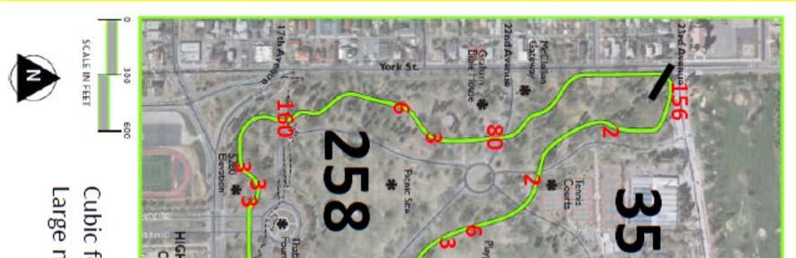
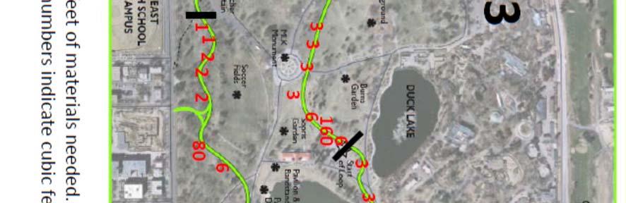
11 Key Areas for Maintenance: Ten key areas needing specific attention on the Mile High Loop are outlined in the following. Cones in the following pictures are shown to provide a sense of scale with alternating cones at ten foot intervals.
: - 160 cubic feet of fill (60x.33x8) cubic feet fill needed is defined as the length of trail to repair in feet X 0.33 o 0.")
12 Problem Area 1 Description: This area is highly saturated throughout summer months due to irrigation flows being consolidated in a low lying area with no cross slope. BMP Recommendations (including Fill): cubic feet of fill (60x.33x8) cubic feet fill needed is defined as the length of trail to repair in feet X 0.33 o 0.33 = 4 to be added to trail for drainage in problem areas o (x8) Trail is variable in width and a mean width of 8 feet is used calculations o 20% compaction is not factored as roughly only 80% of the trail will be raised in an effort to provide adequate sloping and to avoid a dropoff on the trail edge - Crowning of the trail from the center with no outsloping - Trail elevation of 4 above surrounding grade

13 Problem Area 2 Description: This area is highly saturated throughout summer months due to irrigation flows being consolidated along the interior edge of the trail. A second unofficial trail has been formed where the crosswalk at 23 rd Avenue and York Street ends. This area is particularly eroded as it has not been designed to be a trail. BMP Recommendations (including Fill): cubic feet of fill (50x.33x8) (132) + (30x.5x5x1.2) (24) - cubic feet fill needed is defined as the length of trail to repair in feet X 0.33 o 0.33 = 4 to be added to trail for drainage in problem areas o (x8) Trail is variable in width and a mean width of 8 feet is used calculations o (x5) A 5 foot width (0.5) was used for the fill on the access trail from the corner o 20% compaction is not factored to existing trail as roughly only 80% of the trail will be raised in an effort to provide adequate sloping and to avoid a dropoff on the trail edge o 20% compaction was factored in for new trail fill (1.2) - Elevation of the trail 4 above grade with an outslope following grade - Backfill or formal excavation and trail preparation where the newly formed trail meets the Mile High Loop - Consider a drainage ditch if rills continue to form
: - 80 cubic feet of fill (30x.")
14 Problem Area 3 Description: This area includes a slope varying from 2 5 degrees. In this picture, the direction of slope is from the foreground to the background. Water pools and creates a large section of mud during summer months at the toe of the slope. BMP Recommendations (including Fill): - 80 cubic feet of fill (30x.33x8) - cubic feet fill needed is defined as the length of trail to repair in feet X 0.33 o 0.33 = 4 to be added to trail for drainage in problem areas o (x8) Trail is variable in width and a mean width of 8 feet is used calculations o 20% compaction is not factored as roughly only 80% of the trail will be raised in an effort to provide adequate sloping and to avoid a dropoff on the trail edge - - Elevation of the trail 4 above grade with both crowning and a slope following grade to the street intersection - Consider a drainage ditch on the downhill side if rilling/pooling continues
: - 160 cubic feet of fill (60x.33x8) - cubic feet fill needed is defined as the length of trail to repair in feet X 0.33 o 0.")

15 Problem Area 4 Description: This area is highly saturated throughout summer months due to irrigation flows being consolidated in a low lying area with no cross slope. BMP Recommendations (including Fill): cubic feet of fill (60x.33x8) - cubic feet fill needed is defined as the length of trail to repair in feet X 0.33 o 0.33 = 4 to be added to trail for drainage in problem areas o (x8) Trail is variable in width and a mean width of 8 feet is used calculations o 20% compaction is not factored as roughly only 80% of the trail will be raised in an effort to provide adequate sloping and to avoid a dropoff on the trail edge - - Crowning of the trail from the center with no outsloping - Trail elevation of 4 above surrounding grade
: - 160 cubic feet of fill (60x.")
16 Problem Area 5 Description: This area is highly saturated throughout summer months due to irrigation flows being consolidated throughout this portions of the trail. This area is affected in winter by slight shading from a large grove of trees which creates differential melting. BMP Recommendations (including Fill): cubic feet of fill (60x.33x8) - cubic feet fill needed is defined as the length of trail to repair in feet X 0.33 o 0.33 = 4 to be added to trail for drainage in problem areas o (x8) Trail is variable in width and a mean width of 8 feet is used calculations o 20% compaction is not factored as roughly only 80% of the trail will be raised in an effort to provide adequate sloping and to avoid a dropoff on the trail edge - Elevation of the trail 4 above grade with an outslope following grade
: - 80 cubic feet of fill (30x.")
17 Problem Area 6 Description: This area is highly saturated throughout summer months due to flows and sediment being delivered from the uphill immediately adjacent impervious surface. A slope exists which conveys water from the road onto the trail. BMP Recommendations (including Fill): - 80 cubic feet of fill (30x.33x8) - cubic feet fill needed is defined as the length of trail to repair in feet X 0.33 o 0.33 = 4 to be added to trail for drainage in problem areas o (x8) Trail is variable in width and a mean width of 8 feet is used calculations o 20% compaction is not factored as roughly only 80% of the trail will be raised in an effort to provide adequate sloping and to avoid a dropoff on the trail edge - Elevation of the trail 4 above grade with crowning to distribute run on away from the trail - Future consideration of using elevation, porous materials or level spreaders to drain roadway runoff prior to intersection with the trail - Signage to restrict maintenance vehicles and event vehicles using the road from using the loop trail.
: - 158 cubic feet of fill (60x.")
18 Problem Area 7 Description: Areas 7 and 8 are low lying areas that are hit particularly hard with irrigation runoff. These areas are often impassible for the majority of the summer due to high run on and minimal cross slope. BMP Recommendations (including Fill): cubic feet of fill (60x.33x8) - cubic feet fill needed is defined as the length of trail to repair in feet X 0.33 o 0.33 = 4 to be added to trail for drainage in problem areas o (x8) Trail is variable in width and a mean width of 8 feet is used calculations o 20% compaction is not factored as roughly only 80% of the trail will be raised in an effort to provide adequate sloping and to avoid a dropoff on the trail edge - Crowning of the trail from the center with no outsloping - Trail elevation of 4 above surrounding grade - Planting of trees to the north of the trail to replace former tree islands and to provide additional infiltration and interception of irrigation - Consider subsurface drainage to Little Lake via the adjacent drainage swale if problems persist

 Trail is variable in width and a mean width of 8 feet is used calculations o 20% compaction is not factored as roughly only 80% of the")
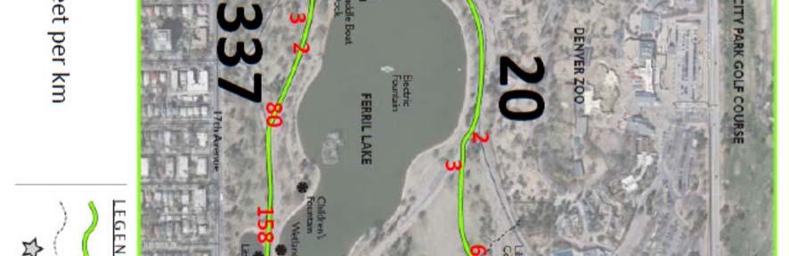
19 Problem Area 8 Description: Areas 7 and 8 are low lying areas that are hit particularly hard with irrigation runoff. These areas are often impassible for the majority of the summer. A second trail which veers to the right of the Mile High Loop in this picture was created by foot traffic when this portion of the trail was closed during construction of a museum expansion and roadway improvements from BMP Recommendations (including Fill): cubic feet of fill (60x.33x8) - cubic feet fill needed is defined as the length of trail to repair in feet X 0.33 o 0.33 = 4 to be added to trail for drainage in problem areas o (x8) Trail is variable in width and a mean width of 8 feet is used calculations o 20% compaction is not factored as roughly only 80% of the trail will be raised in an effort to provide adequate sloping and to avoid a dropoff on the trail edge - Crowning of the trail from the center with no outsloping - Trail elevation of 4 above surrounding grade - Re vegetation of the trail that was created during museum construction - Consider ditching which connects to subsurface drainage to Little Lake if problems persist

20 Problem Area 9 Description: This area is a new segment of the trail that was created when it was necessary to re orient the trail to accommodate reclaimed water infrastructure (aka purple pipe). This area has impacts from bicycle traffic as it both connects the bike trail in the park to the intersection of Colorado Boulevard and 17 th Avenue and incorporates an acute angled arc. Mechanical grooming of the trail in October, 2014 greatly improved the surface in this area. BMP Recommendations (including Fill): cubic feet of fill (50x.33x8) - cubic feet fill needed is defined as the length of trail to repair in feet X 0.33 o 0.33 = 4 to be added to trail for drainage in problem areas o (x8) Trail is variable in width and a mean width of 8 feet is used calculations o 20% compaction is not factored as roughly only 80% of the trail will be raised in an effort to provide adequate sloping and to avoid a dropoff on the trail edge - Elevation of the trail 4 above grade with an outslope following grade


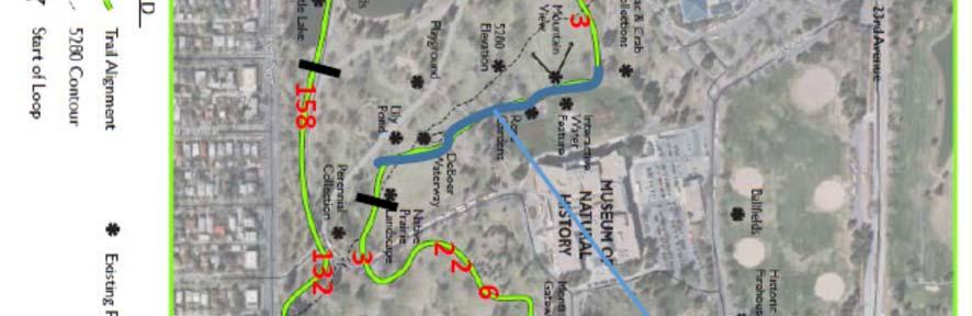
21 Problem Area 10 Southern Extent of Area 10 Northern Extent of Area 10
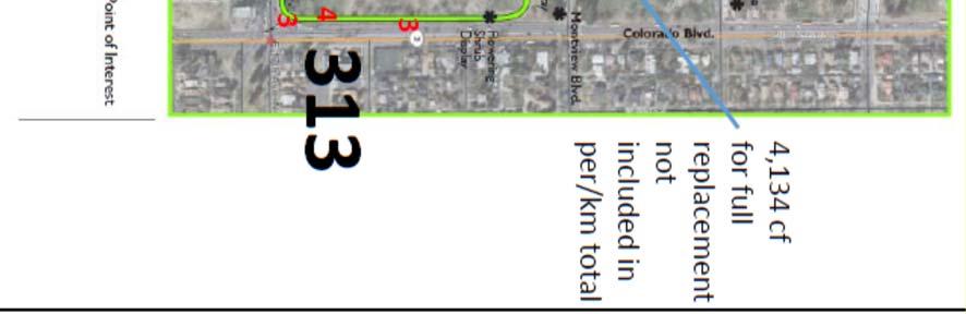
22 Description: The Mile High Loop borders a hardened surface in three areas. Along York Street, the Mile High Loop borders a sidewalk. In this area, the Mile High Loop reduces to a width of 36. Along Colorado Boulevard, the Mile High Loop borders a sidewalk with a width of 30. In this section, where the Mile High Loop intersects the lawn in front of the Denver Museum of Nature and Science (i.e., the Mountain View ), the loop trail is anywhere between 10 wide and non existent. This is a long stretch of trail needing repair. It is 650 feet long. Additional impacts to this section occur from rill erosion associated with the H20 Odyessey fountain pumps and a storm sewer outfall near this area s southern extent. BMP Recommendations (including Fill): - Direct water from the storm sewer outfall either away from the trail or level the water into laminar sheet flow prior to intersection the trail - Fill needed = 4,134 cubic feet (650x.67x1.2x8) - cubic feet fill needed is defined as the length of trail to repair in feet X 0.67 o 0.67 = 8 depth for new trail construction o (x8) Trail is variable in width and a mean width of 8 feet is used calculations - 20% compaction (1.2) is factored in for new trail construction *Preferred option Complete removal of the hardened trail for the entire 650 foot length of this section and re installing a crusher fine trail in this area. This area of hardened surface is no longer necessary for maintenance, since the concrete walkway adjacent to the H20 Odyssey fountain now serves as a better route for maintenance vehicles.
23 Delivery and Quantity of Materials Needed on the Mile High Loop for the April 22, 2015 Rehabilitation: On April 22, the Mile High Loop will be restored. Labor will be provided primarily through the Starbucks Day of Work, with additional participation by Registered Neighborhood Associations, interested public, and It is the goal of City Park Alliance to rehabilitate the entire Mile High Loop during this period. Prior to the delivery of materials, City Park Alliance will mark the trail and provide laminated Standard Operating Procedure specification sheets to guide volunteers on how to rehabilitate the trail based on each marked area as requested to support Denver Parks and Recreation. Where possible, compaction, wetting, and re compaction should be utilized in all areas. The use of vibratory plate compactors, a miniature dump truck with smooth tread tires, several leveling bars, a portable water source and delivery of materials The following assessment provides the quantity of crusher fines needed and provides quantities of crusher fines that are needed for each kilometer of trail. Quantities are provided in cubic feet of material necessary. Larger fonts indicate areas where crusher fines should be delivered and are marked at points accessible to concrete roads. A total quantity of 1,281 cubic feet of material (48 cubic yards) is recommended for this initial project. A follow up delivery of 10 cubic yards of material is also being recommended for delivery on a later date (e.g., June 5) to address irrigation impacts recognized after the April 22 rehabilitation. Costs/Material Estimates: ~$1, cubic yards crusher fines with $100 surcharge for delivery to multiple locations ~$700 Equipment rental if needed ~$300 Water/supplies to support volunteers ~$450 Follow up delivery of 10 cubic yards crusher fines with $100 surcharge Problem Area 10 Additional Costs: ~$330 Cut asphalt $.51 per linear foot minimum charge ~$6,500 Remove asphalt 6,500 sf estimate ~$5, cubic yards crusher fines ~$6,500 Install/site prep costs ~$1,000 Site re vegetation
24
APPENDIX D: SUSTAINABLE TRAIL DESIGN. APPENDICES Town of Chili Parks and Recreation Master Plan Update
 APPENDIX D: SUSTAINABLE TRAIL DESIGN APPENDICES Town of Chili Parks and Recreation Master Plan Update Sustainable Trail Construction Sustainable trails are defined by the US Forest Service as trails having
Sandbag Barrier. Suitable Applications Sandbag barriers may be suitable: As a linear sediment control measure:
 Categories EC Erosion Control SE Sediment Control TC Tracking Control WE Wind Erosion Control Non-Stormwater NS Management Control Waste Management and WM Materials Pollution Control Legend: Primary Category
Permeable RECREATIONAL TRAILS
 SMART EARTH SOLUTIONS Permeable RECREATIONAL TRAILS GEOWEB GEOPAVE GEOTERRA Innovative Solutions for Designing & Building Trails. Trail Surface Stabilization The key to planning and building trails into
Bear Creek Habitat Improvement Project
 06/10/10 Bear Creek Habitat Improvement Project El Paso County, Colorado Pike National Forest and Colorado Springs Utilities Owned Land Report prepared by: Eric Billmeyer Executive Director Rocky Mountain
Understanding user expectations And planning for long term sustainability 1
 Understanding user expectations And planning for long term sustainability 1 What is a natural surface trail? It can be as simple has a mineral soil, mulched or graveled pathway, or as developed as elevated
Appendix A Appendix A (Project Specifications) Auk Auk / Black Diamond (Trail 44) Reroute
 Auk Auk / Black Diamond (Trail 44) Reroute") Appendix A (Project Specifications) Auk Auk / Black Diamond (Trail 44) Reroute I. Proposed Action: This project proposes to reroute approximately 1,800 feet of a 50 inch wide trail, off of private property
Appendix A (Project Specifications) Auk Auk / Black Diamond (Trail 44) Reroute I. Proposed Action: This project proposes to reroute approximately 1,800 feet of a 50 inch wide trail, off of private property
ROAD AND TRAIL PROJECT APPROVAL
 ROAD AND TRAIL PROJECT APPROVAL www.marincountyparks.org Marin County Parks, 3501 Civic Center Dr, Suite 260, San Rafael, CA 94903 DATE: July 12, 2017 PRESERVE: Gary Giacomini Open Space Preserve PROJECT:
DRAFT. Dorabelle Campground Rehabilitation
 DRAFT Dorabelle Campground Rehabilitation September 2012 1.1 REGIONAL SETTING AND PROJECT LOCATION The Dorabelle Campground is located on the western shore of Shaver Lake in Fresno County, California (Section
Group similar facilities together separate dissimilar facilities.
 Park design Principle #1 Group similar facilities together separate dissimilar facilities. Why do we do this? Safety Differences in admission fees Differences in seasonal use Reduce user conflicts Principle
Contents. iii. contents
 Contents Chapter 3: Design Requirements for Sustainable Trails...95 Trail Corridor...98 Tread Design...99 Full Bench Trail Tread...99 Partial Bench Trail Tread... 100 Trail Tread and Materials... 100 Various
Appendix 3. Greenway Design Standards. The Whitemarsh Township Greenway Plan
 Appendix 3 Greenway Design Standards This chapter discusses two design standards for the greenway types discussed above. First, trail design standards are presented together with trailhead facilities and
City of Durango 5.8 FUNDING TRAILS DEVELOPMENT
 5.8 FUNDING TRAILS DEVELOPMENT The City has been successful in establishing dedicated local funding sources as well as applying for grants to develop the City s trail system, having received nearly $2.4
INTRODUCTION. Mailing address: Burke County Community Development Attn: Tim Johnson P. O. Box 219 Morganton, NC
 REQUEST FOR QUALIFICATIONS: PROFESSIONAL, EXPERIENCED TRAIL BUILDERS FOR THE CONSTRUCTION OF THE FONTA FLORA STATE TRAIL LAKE JAMES SECTION BURKE COUNTY COMMUNITY DEVELOPMENT INTRODUCTION Burke County
Great Pond Mountain Conservation Trust Request for Bids Wildlands Hillside Trail Relocation and Restoration Project
 Great Pond Mountain Conservation Trust Request for Bids Wildlands Hillside Trail Relocation and Restoration Project Project Description: Great Pond Mountain Conservation Trust (GPMCT), a nonprofit land
Wicking Geosynthetic Used for Frost Heave Prevention Pioneer Mountain Scenic Byway
 Wicking Geosynthetic Used for Frost Heave Prevention Pioneer Mountain Scenic Byway Mark Sikkema TenCate 365 South Holland Drive Pendergrass, GA 30567 (760)-693-1800 m.sikkema@tencate.com James B. Carpita,
The Whitefish Trail
 The Trail - 2017 Trail Construction Specifications & Scope of Services The Lower Haskill section of Trail construction will take place on two different land ownerships: City of and Iron Horse. This section
FULL DEPTH RECLAMATION (FDR)
") FULL DEPTH RECLAMATION (FDR) Virginia Experience Past and Present Michael Wells, P.E. March 2, 2018 Outline What is Full Depth Reclamation (FDR) VDOT Experience Full Depth Reclamation (FDR) Bound layers
FULL DEPTH RECLAMATION (FDR) Virginia Experience Past and Present Michael Wells, P.E. March 2, 2018 Outline What is Full Depth Reclamation (FDR) VDOT Experience Full Depth Reclamation (FDR) Bound layers
Kennesaw Mountain Trail Club. Trail Skills Workshop ~ Dips and Drains. Presented by: Jay M Dement
 Kennesaw Mountain Trail Club Trail Skills Workshop ~ Dips and Drains Presented by: Jay M Dement KEY CONCEPTS: Control Erosion and Users Where Do Trails Come From, and How Do They Work: Concept of trail
2. STAKEHOLDER FEEDBACK // What We Heard
 1. QUARRY ROAD TRAIL // Welcome to the Information Session PROJECT DESCRIPTION WHY WE ARE HERE Quarry Road Trail is a popular commuter trail and recreational area for Calgarians. 1. To report citizen feedback
MORGAN CREEK GREENWAY Final Report APPENDICES
 APPENDICES MORGAN CREEK GREENWAY Appendix A Photos of Existing Conditions in Trail Corridor Photos of existing conditions Main trail corridor - February 2009 Photos of existing conditions south bank Morgan
VI. ALTERNATIVES TO THE MASTER PLAN C. RENOVATED EAST BUILDING ALTERNATIVE
 VI. ALTERNATIVES TO THE MASTER PLAN C. RENOVATED EAST BUILDING ALTERNATIVE INTRODUCTION The Renovated East Building Alternative would include the continued use of the renovated West Building and the renovation
American Conservation Experience
 ACE Project Report For Tonto National Forest, Arizona Trail Association and Arizona State Parks Title of Project: 4 Peaks Trail Maintenance Award Contract Number: ASP NM11021 Project Partner: Paul Burghard
Trail Phasing Plan. Note: Trails in the Clear Creek Canyon area (Segments will be finalized in the future to minimize wildlife impacts
 Note: Trails in the Clear Creek Canyon area (Segments 2 5 and a future JCOS connection) will be finalized in the future to minimize wildlife impacts Trail Phasing Plan P Parking 3 Easy Trail Intermediate
Property access tracks
 Property access tracks Planning, location, construction and maintenance The need for farm roads and tracks The efficient running of a property depends on, among other things, ready access to various locations
Trails Design and Management Handbook
 Trails Design and Management Handbook OPEN SPACE PITKIN AND TRAILS COUNTY Open Space and Tr ails Progr am Pitkin County, Color ado Pitkin County Open Space and Trails Program Trails Design and Management
Ditch flows slowly to the north
 Ditch flows slowly to the north Photo 1. Wetland DE: Looking west across Wetland DE from upslope. Ponded water, mucky mineral soils, and patches of emergent vegetation observed. Wetland DE appears to be
Trail Assessment Report
 Trail Assessment Report Trail Options for the Bear Creek Canyon located in Pikes Peak Ranger District, Pike National Forest and on Colorado Springs Utility Lands Due to the presence of a unique species
Volunteer Project Trip Report Yosemite National Park May 16-20, 2012
 Conservation Volunteers International Program 120 Village Square #9 Orinda, California 94563 USA www.conservationvip.org A Non-Profit 501c3 Tax Exempt Organization CST 2089890-40 Volunteer Project Trip
Head Pond Connector Trail Final Report Project Area: From Head Pond in Berlin to Rt. 110B in Milan
 Milan Trail Huggers ATV Club P.O. Box 42 Milan, NH 03588 Maintaining Trails in Milan, Stark and Dummer Head Pond Connector Trail Final Report Project Area: From Head Pond in Berlin to Rt. 110B in Milan
Lake Wissota Access Locations within the LaFayette Township. By Chad Martin
 Lake Wissota Access Locations within the LaFayette Township By Chad Martin Anson/ Wissota Access Point # 1 Road: 195 th St. Associated Fire Numbers: 13294 Defining Characteristics: Forested from road
DATE: 23 March, 2011 TO: Communities FROM: BlazeSports America. RE: Accessible Trails Checklist 1
 M E M O R A N D U M DATE: 23 March, 2011 TO: Communities FROM: BlazeSports America RE: Accessible Trails Checklist 1 The purpose of the Accessible Trails Checklist (below) is to help the community review
KENNESAW MOUNTAIN TRAIL CLUB WORKDAY
 WORKDAY 2-10-18 1 Trail ambassadors or others see next page. 1 work sites TOOLS 15 1 3 1 2 SCHEDULE: 7:15 Start load tools; Send registration stuff out 8:00 Send tools to grassy area near trail head. 8:15
Agenda Report. Spruce Street Outlet Drainage Improvements Tower Road Relief Sewer
 Agenda Report Subject: Prepared By: Spruce Street Outlet Drainage Improvements Tower Road Relief Sewer Steven M. Saunders, Director of Public Works/Village Engineer Date: August 12, 2012 On March 8, 2012
KENNESAW MOUNTAIN TRAIL CLUB WORKDAY
 WORKDAY 4-14-18 1 Trail ambassadors or others see next page. 1 TOOLS HERE 2 1 7 20 Work for 4-14-18 will again be on the lower portion of the Mountain Trail below the fire road. Due to safety considerations,
K SIGNAGE & TRAFFIC CONTROL. Table of Contents
 Table of Contents K1. ACCOMMODATION OF TRAFFIC... 1 K2. MINIMUM CONSTRUCTION SIGNING... 1 K3. SUBDIVISION SIGNS... 2 K4. TRAFFIC CONTROL DEVICES... 2 K4.1 Traffic Signs Regulations... 2 K4.2 Materials...
National Forests and Grasslands in Texas
 United States Department of Agriculture Forest Service National Forests and Grasslands in Texas Sam Houston NF 394 FM 1375 West New Waverly, Texas 77358 Phone 936-344-6205 Dear Friends, File Code: 1950
The National Path Demonstration Site
 The National Path Demonstration Site at Battleby an introductory guide Good paths are essential if people are to enjoy the outdoors. Thoughtful path design really opens up access but there s more to building
ETOBICOKE CREEK NORTH TRAIL PROJECT. May 18, 2017 at Michael Power High School 105 Eringate Drive, Etobicoke ON M9C 3Z7
 ETOBICOKE CREEK NORTH TRAIL PROJECT May 18, 2017 at Michael Power High School 105 Eringate Drive, Etobicoke ON M9C 3Z7 1 Purpose of Open House The purpose of today s open house is to present the design
Logo Department Name Agency Organization Organization Address Information 5700 North Sabino Canyon Road
 Logo Department Name Agency Organization Organization Address Information United States Forest Coronado National Forest 5700 North Sabino Canyon Road Department of Service Santa Catalina Ranger District
CENTER PIVOT TRACK MANAGEMENT OPTIONS
 Proceedings of the 28th Annual Central Plains Irrigation Conference, Kearney, Nebraska, February 23-24, 2016 Available from CPIA, 760 N. Thompson, Colby, Kansas CENTER PIVOT TRACK MANAGEMENT OPTIONS Steven
Rocky Mountain Field Institute
 Rocky Mountain Field Institute Palmer Park Stewardship Project 2016 Annual Project Report December 20, 2016 Report prepared by: Andy Riter, Program Coordinator and Alex Hladkyj, Field Instructor 815 South
DD FORM 3009, FEB 2016 REPLACES DA FORM 1247, WHICH IS OBSOLETE. Page 1 of 6 Pages Adobe Professional X
 ROUTE CLASSIFICATION For use of this form, see ATP 3-34.81/MCWP 3-17.4; the proponent agency is TRADOC. SECTION I 1. SERIAL NUMBER 2. TO 3. FOR INFORMATION 4. DATE/TIME GROUP 5. NUMBER OF SHEETS OR ENCLOSURES
TRAIL MAINTENANCE AND CONSTRUCTION MANUAL
 TRAIL MAINTENANCE AND CONSTRUCTION MANUAL MAINTAINING THE TRAIL CORRIDOR GENERAL MAINTENANCE Debris and Obstacles Remove dangerous obstacles that riders may fall on - logs and branches one-half inch in
2015 WORKSHOP Wednesday Field Sites
 2015 WORKSHOP Wednesday Field Sites 1. George Road: Butler County: Active D&G site: The bus will stop on a hill where several crosspipes have been added and an infiltration basin has been installed at
Runway Roughness Evaluation- Boeing Bump Methodology
 FLIGHT SERVICES Runway Roughness Evaluation- Boeing Bump Methodology Michael Roginski, PE, Principal Engineer Boeing Airport Compatibility Engineering ALACPA XI Seminar, Santiago, Chile September 1-5,
Non-motorized Trail Plan & Proposal. August 8, 2014
 Town of Star Valley Ranch, Wyoming and the Star Valley Ranch Association in partnership with the USDA Forest Service, Bridger-Teton National Forest, Greys River Ranger District Non-motorized Trail Plan
Environmentally Sensitive Maintenance for Dirt & Gravel trails TRAIL MIX. TRAIL MIX: aggregate for trails
 TRAIL MIX: aggregate for trails Environmentally Sensitive Maintenance for Dirt & Gravel trails Penn State University: Center for Dirt and Gravel Road Studies Dave Shearer drs32@psu.edu www.dirtandgravelroad.org
METROPOLITAN COUNCIL 390 North Robert Street, St. Paul, MN Phone (651) TDD (651)
 TDD (651)") METROPOLITAN COUNCIL 390 North Robert Street, St. Paul, MN 55101 Phone (651) 602 1000 TDD (651) 291 0904 DATE: June 19, 2007 TO: Metropolitan Parks and Open Space Commission FROM: Jan Youngquist, Senior
METROPOLITAN COUNCIL 390 North Robert Street, St. Paul, MN 55101 Phone (651) 602 1000 TDD (651) 291 0904 DATE: June 19, 2007 TO: Metropolitan Parks and Open Space Commission FROM: Jan Youngquist, Senior
Abstract. Introduction
 STATE OF PRACTICE OF GEOTECHNICAL ENGINEERING FOR DESIGN OF CUSTOM HOMES IN THE HOUSTON AREA BETWEEN 1990 AND 2001 BY BY DAVID A. EASTWOOD, P.E. 1 BY FRANK ONG, P.E. 2 PRESENTED AT FOUNDATION PERFORMANCE
Runway Roughness Evaluation- Boeing Bump Methodology
 FLIGHT SERVICES Runway Roughness Evaluation- Boeing Bump Methodology Michael Roginski, PE, Principal Engineer Boeing Airport Compatibility Engineering ALACPA X Seminar, Mexico City, Mexico September 30-
Runway Roughness Evaluation- Boeing Bump Methodology
 FLIGHT SERVICES Runway Roughness Evaluation- Boeing Bump Methodology Michael Roginski, PE, Principal Engineer Boeing Airport Compatibility Engineering ALACPA X Seminar, Mexico City, Mexico September 3-
WASHINGTON STATE PARKS AND RECREATION COMMISSION POLICY/PROCEDURE
 WASHINGTON STATE PARKS AND RECREATION COMMISSION POLICY/PROCEDURE 65-13-1 Use of Other Power-Driven Mobility Devices by Persons with Mobility Disabilities at State Park Facilities See Also: 28 CFR 35 Title
Geomorphology. Glacial Flow and Reconstruction
 Geomorphology Glacial Flow and Reconstruction We will use simple mathematical models to understand ice dynamics, recreate a profile of the Laurentide ice sheet, and determine the climate change of the
Project Update Utah Water Users Workshop March 14, 2012
 Project Update Utah Water Users Workshop March 14, 2012 Jeffrey D. Budge, P.E. Operations and Engineering Manager Steven H. Cain Facilities and Lands Manager Organized in 1935 Deer Creek Division of the
Appendix C. Tenderfoot Mountain Trail System. Road and Trail Rehabilitation Plan
 Appendix C Tenderfoot Mountain Trail System Road and Trail Rehabilitation Plan All rehabilitation work would be under the direction of the District Fisheries Biologist, the Forest Hydrologist, and/or the
Typical avalanche problems
 Typical avalanche problems The European Avalanche Warning Services (EAWS) describes five typical avalanche problems or situations as they occur in avalanche terrain. The Utah Avalanche Center (UAC) has
Kit Carson-Challenger Ridge Trail Project
 Kit Carson-Challenger Ridge Trail Project Project Accomplishments Report-USFS December 15, 2015 Photo courtesy of Justin Peterson 815 South 25 th Street, Suite 101 Colorado Springs, CO 80904 Dedicated
Beaver Creek State Park
 GENERAL INFORMATION Name of Park/Forest/Facility: Beaver Creek State Park County: Columbiana (St. Clair Township) Address: 12816 Sprucevale Road (ie County Rd 428) (street #, city) East Liverpool, Ohio
Rule Governing the Designation and Establishment of All-Terrain Vehicle Use Trails on State Land
 Rule Governing the Designation and Establishment of All-Terrain Vehicle Use Trails on State Land 1.0 Authority 1.1 This rule is promulgated pursuant to 23 V.S.A. 3506. Section 3506 (b)(4) states that an
Design Considerations For Accessible Parks & Trails
 Design Considerations For Accessible Parks & Trails Measuring Up: Campbell River 2008 Dave Calver Consulting City of Campbell River Legacies Now: Measuring Up Design Guidelines Design Considerations for
Project Report Volunteer Trip Torres del Paine National Park, Patagonia, Chile December 3-15, Executive Summary
 Conservation Volunteers International Program 120 Village Square #9, Orinda, California 94563 USA www.conservationvip.org info@conservationvip.org Tel: (925) 228-5946 A Non-Profit 501c3 Tax Exempt Organization
Section 3-04 Cross Sectional Elements TABLE OF CONTENTS. INTRODUCTION...3 General...3 Exhibit 1-Cross-Sectional Elements...3
 Section 3-04 Cross Sectional Elements TABLE OF CONTENTS INTRODUCTION...3 General...3 Exhibit 1-Cross-Sectional Elements...3 CROSS-SECTIONAL ELEMENTS...3 Traveled Way...3 Shoulder...3 Surfacing Taper...3
STRATEGIES FOR PROTECTING YOUR PROPERTY
 STRATEGIES FOR PROTECTING YOUR PROPERTY A Homeowner s Guide for Flood, Debris, and Erosion Control after the High Park Fire (Includes tips on how to properly use sandbags) Larimer County Engineering Department
Longmont to Boulder Regional Trail Jay Road Connection DRAFT FINAL REPORT
 Longmont to Boulder Regional Trail Jay Road Connection DRAFT FINAL REPORT December 2018 Project Summary Boulder County, Colorado, in partnership with the City of Boulder, is evaluating options for multi-use
EXECUTIVE SUMMARY FALL Introduction. Findings
 EXECUTIVE SUMMARY FALL 2004 Introduction Trails are one of the most popular and highly desirable recreational resources in communities of all sizes throughout the country. In addition to providing a safe
NEW MEADOWS PARK PROPOSED MASTER PLAN
 NEW MEADOWS PARK PROPOSED MASTER PLAN A vision for your neighborhood park, the draft master plan is ready for your review. Tuesday September 12 th, 2017 5:30-7:00 PM Hellgate School District #4 middle
The Baker/Carver Regional Trail is intended to
 Section V Design Guidance The Baker/Carver Regional Trail is intended to safely accommodate 183,000 annual visits, an array of non-motorized uses, a variety of skill levels, and persons with special needs.
City of Fort Lauderdale. Frequently Asked Questions. Proposed Sea Wall Ordinance
 City of Fort Lauderdale Frequently Asked Questions Proposed Sea Wall Ordinance The City of Fort Lauderdale is considering amending the Unified Land Development Regulations of the City of Fort Lauderdale
Minnesota Off-Road Cyclists
 Minnesota Off-Road Cyclists MORC Mission Minnesota Off-Road Cyclists is a nonprofit volunteer organization dedicated to safeguarding the future of mountain biking in Minnesota through the promotion of
THERMACAPTURE NEOAIR MATTRESSES RIDGEREST AND Z LITE MATTRESSES
 THERMACAPTURE THERMACAPTURE ThermaCapture Radiant Heat Technology is a proprietary reflective coating that we apply to a range of surfaces. By reflecting radiant heat back to your body that is otherwise
Briarhill Neighborhood Polecat Priority List. Exhibit D-4
 Briarhill Neighborhood Polecat Priority List Exhibit D-4 March 11, 2013 The following list of trail head issues and design elements was developed by Briarhill 2/3 neighborhood residents living near the
Lake Apopka Trail Loop Design Guidelines
 November 2002 Prepared for 14908 Tilden Road Winter Garden, FL 34787 Prepared by 140 North Orlando Avenue Suite 295 Winter Park, FL 32789 November, 2002 I. INTRODUCTION...1 II. DESIGN GUIDELINES FOR TRAILS...3
THE SUPERGUARD SERIES EXPANDABLE CROWD CONTROL BARRIERS
 THE SUPERGUARD SERIES EXPANDABLE CROWD CONTROL BARRIERS SUPERGUARD Super-Guard is a portable, free-standing expandable crowd control barrier that is ideal for use in rigorous and tough applications such
United States Department of the Interior National Park Service. Boundary Expansion Listed in National Register January 11, 2017
 NPS Form 10900-a (Rev. 8/2002) OMB No. 10240018 United States Department of the Interior National Park Service Boundary Expansion Listed in National Register January 11, 2017 National Register of Historic
YOUR GUIDE TO GARAGE ORGANIZATION 2GARAGE SOLUTIONS TAILORED TO THE WAY YOU LIVE
 YOUR GUIDE TO GARAGE ORGANIZATION 2GARAGE SOLUTIONS TAILORED TO THE WAY YOU LIVE 1 YOUR GARAGE, REIMAGINED It s time to dream outside the box. The garage used to be a place to park the car and store all
Buena Vista Community Trails Plan
 Buena Vista Community Trails Plan Prepared by the Buena Vista Trails Advisory Board For the Buena Vista Board of Trustees May 2008 Table of Contents Acknowledgments 1 Introduction 1 I. Trails and the Town
Procedure for the Use of Power-Driven Mobility Devices on Mass Audubon Sanctuaries 1 September 17, 2012
 Procedure for the Use of Power-Driven Mobility Devices on Mass Audubon Sanctuaries 1 September 17, 2012 Background As part of Mass Audubon s mission to preserve the nature of Massachusetts for people and
Course 102. Tread and Drainage
 PCTA Trail Skills College Curriculum Instructor Planning Guide Water and gravity constantly threaten our trails and thus we must learn how best to deflect them. This course begins with basics of hillside
Peter Axelson. Beneficial Designs, Inc. Minden, NV
 Peter Axelson Beneficial Designs, Inc. Minden, NV Arroya Sit Ski Mono Ski Dynamic Seating Spring Assist Cross Country Ski Hand Bike Adaptive Canoe Seating Available from Chosen Valley Canoe Accessories
Outdoor Developed Areas
 The United States Access Board is an independent federal agency that promotes equality for people with disabilities through leadership in accessible design and the development of accessibility guidelines
What s covered. What s not covered. Options for those not covered. ABA Coverage
 The United States Access Board is an independent federal agency that promotes equality for people with disabilities through leadership in accessible design and the development of accessibility guidelines
Reuse of RAP in asphalt pavements. RAP = Recycled Asphalt Pavement also called millings or grindings from:
 PASS Recycle/RAP Applications Definition RAP = Recycled Asphalt Pavement also called millings or grindings from: bump grinding of hot mix pavements millings from mill and fill operations large chunks of
FEASIBILITY CRITERIA
 This chapter describes the methodology and criteria used to evaluate the feasibility of developing trails throughout the study areas. Land availability, habitat sensitivity, roadway crossings and on-street
Section 61 Recreational Vehicle Park / Campground (Bylaw No. 2012/10)
") Part 7 General Regulations Section 61 Recreational Vehicle Park / Campground (Bylaw No. 2012/10) 61.1 A comprehensive site plan shall be provided to the satisfaction of the Development Authority that shows
Part 7 General Regulations Section 61 Recreational Vehicle Park / Campground (Bylaw No. 2012/10) 61.1 A comprehensive site plan shall be provided to the satisfaction of the Development Authority that shows
Assessing Your Trails, Keeping Them Safe and Enjoyable
 Jon Wood, PLA, ASLA Associate Vice President Stewart Bert Lynn, PLA, ASLA, LEED AP Project Manager Mecklenburg County Asset and Facility Management Assessing Your Trails, Keeping Them Safe and Enjoyable
Universal Access Trails and Shared Use Paths
 Universal Access Trails and Shared Use Paths Design, Management, Ethical, and Legal Considerations Edition of November 4, 2014 Debra Wolf Goldstein, Esq. Larry Knutson Find the most recent edition of this
INSTALLATION INSTRUCTIONS FOR BALCO, INC. FLOOR MATS FM2R-(A, C, D) W/O FRAME 4V
 W/O FRAME 4V") 2626 South Sheridan PO Box 17249 Wichita, Kansas 67217 Phone: (316) 945-9328 Fax: (316) 945-0789 INSTALLATION INSTRUCTIONS FOR BALCO, INC. FLOOR MATS FM2R-(A, C, D) W/O FRAME 4V 2012, Balco, Inc. INSTALLATION
2626 South Sheridan PO Box 17249 Wichita, Kansas 67217 Phone: (316) 945-9328 Fax: (316) 945-0789 INSTALLATION INSTRUCTIONS FOR BALCO, INC. FLOOR MATS FM2R-(A, C, D) W/O FRAME 4V 2012, Balco, Inc. INSTALLATION
Trails Classification Steering Team Alberta Tourism, Parks and Recreation Alberta Sustainable Resource Development Alberta TrailNet Society
 Acknowledgements Alberta Recreation Corridor and Trails Designation Program Alberta Recreation Corridors Coordinating Committee Trails Classification Steering Team Alberta Tourism, Parks and Recreation
Port Gamble Shoreline Area Conceptual Trail Proposal
 The North Kitsap Trails Association is pleased to be a partner to the Kitsap Forest and Bay Project and assist Kitsap County, Forterra, Olympic Property Group, Great Peninsula Conservancy and the Port
Appendix A. Tenderfoot Mountain Motorcycle Trail System. Maintenance and Construction Plan (6/13/13)
") Appendix A Tenderfoot Mountain Motorcycle Trail System Maintenance and Construction Plan (6/13/13) If the decision to implement the project as approved, grant funding would be pursued to fund construction
Appendix A Tenderfoot Mountain Motorcycle Trail System Maintenance and Construction Plan (6/13/13) If the decision to implement the project as approved, grant funding would be pursued to fund construction
Header i
 Header i 048285014.10 Header Sub Title Body Text here. Body text here. Body text here. Section 1... 1 Executive Summary... 1 Opportunities and Constraints... 3 Overall Opportunities and Constraints Map
NEWBORO AND PORTLAND HARBOUR REDVELOPMENT PLANS
 INTRODUCTION The Municipal docks in both Newboro and Portland were transferred to the Township of Rideau Lakes by Parks Canada in 2002. Little has been done to improve the docks physical condition or role
SUPERIOR PERFORMANCE AND PROTECTION CoverLogix Pool Covers
 SUPERIOR PERFORMANCE AND PROTECTION CoverLogix Pool Covers coverlogix.com CoverLogix Advanced Safety Cover Systems WHAT MAKES COVERLOGIX SAFETY COVERS THE INTELLIGENT CHOICE? CoverLogix pool covers are
Theme: Predominately natural/natural appearing; rustic improvements to protect resources. Size*: 2,500 + acres Infrastructure**:
 Recreation Opportunity Spectrum (ROS) Classes The Recreation Opportunity Spectrum (ROS) provides a way to describe the variations in the degree of isolation from the sounds and influences of people, and
Best Practices for The Development of Snowmobile Trails
 Best Practices for The Development of Snowmobile Trails The Vermont Association of Snow Travelers, Inc Revised 7/2017 Overview Construction and maintenance of snowmobile trails is ongoing. Trails must
National Recreation Trail Update Form
 National Recreation Trail Update Form Introduction Thank you for taking the time to complete this form. Your assistance will help ensure that the National Recreation Trail (NRT) database is complete and
Griffith Park Trail Run Trail Guide Click for
 The Griffith Park Trail Run by Hike- LosAngeles.com Griffith Park Trail Run Trail Guide Click for downloadable cell phone guide and map from EveryTrail. DISTANCE: 4.55 Miles ELEVATION: 1280' ELEVATION
Picnic Units A picnic unit is a part of a picnic area
 Grab Bars Grab bars are usually provided in buildings to provide stability and allow a person to use his or her arms to assist in movement over short distances. The most common location for grab bars is
CITY COUNCIL AGENDA MEMORANDUM
 To: Mayor and City Council From: Charles Ozaki, City and County Manager Prepared By: Kevin Standbridge, Deputy City and County Manager Katie Allen, City and County Engineer David Shinneman, Community Development
Members of the York Region Accessibility Advisory Committee. Accessibility Design Guidelines for York Regional Forest Trails
 Environmental Services Department Environmental Promotion and Protection Branch MEMORANDUM TO: FROM: Members of the York Region Accessibility Advisory Committee Ian Buchanan, Manager, Natural Heritage