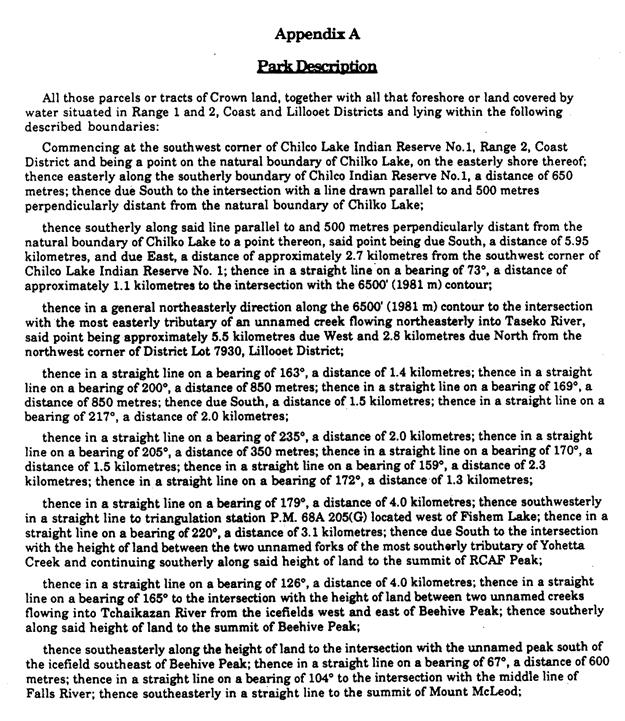
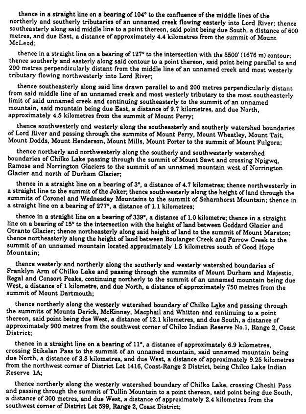
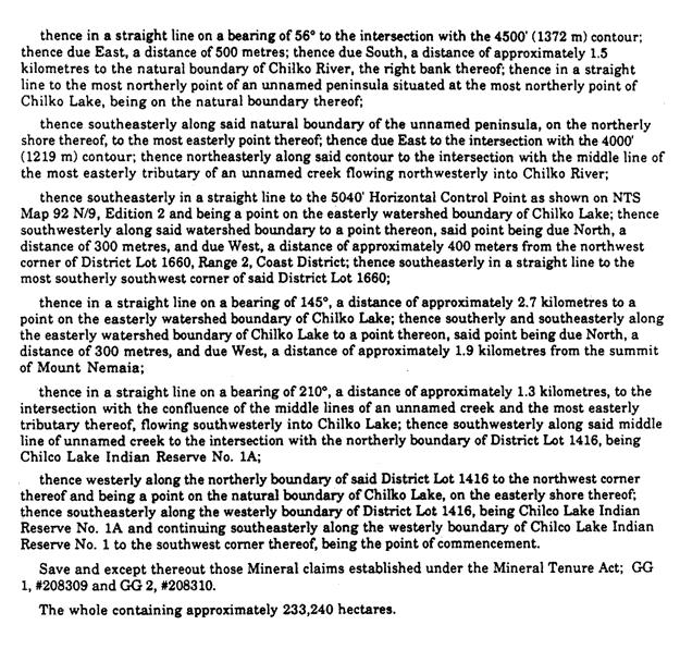
Appendix A Chilko Lake Protected Area Intent and Management Principles
|
|
|
- Penelope Whitehead
- 5 years ago
- Views:
Transcription
1 Appendix A Chilko Lake Protected Area Intent and Management Principles 95
2 Intent and Management Principles (as prescribed by the Chilko Lake Study Team) General Intent This proposed Chilko Lake Protected Area contains important ecological systems, wildlife populations, Aboriginal cultural sites, recreation opportunities, special natural features and outstanding scenery. Of primary management significance to the area is the continued ability to support traditional activities in it while maintaining the integrity of its biodiversity and wilderness values. the roadless, remote character of the area should be linked with traditional activities, and managed within a formal protected area. Management Principles To manage the area as a protected area according to the intent established by the Chilko Lake Study Team and as described by the activity matrix. To protect and manage the natural values and recreation and tourism opportunities of this area in recognition of their significance to the whole province. Activities and levels of use that are compatible with wilderness setting and protection of ecological values will be permitted. To honour current or traditional activities in this area, as indicated in the activity matrix. To recognize the special spiritual and cultural significance of the Chilko Lake area, particularly Mount Tatlow (Ts'il?os ), to the Nemiah Valley Indian Band (Xeni Gwet'in), and to work with the Band in developing a management plan for the area. To develop a protected area management plan based on the activity matrix. To involve affected interests directly in the development and implementation of a protected area management plan through creation of a Local Advisory Group. 96
3 Appendix B Chilko Lake Protected Area Activity Matrix 97
4 Chilko Lake Protected Area Activity Matrix (as prescribed by the Chilko Lake Study Team) Activity List Permitted 1 Restricted 2 Not Permitted Explanation/Rational for Restrictions or Special Management Requirements Aboriginal Uses _ Traditional Aboriginal activities for sustenance, medicinal and spiritual purposes are self-regulated by Nemiah Valley Indian Band (Xeni Gwet'in). Fish and Wildlife habitat and population enhancement _ Habitat enhancement should reflect biodiversity conservation objectives. Fishing _ Subject to existing regulations. Hunting _ Subject to existing regulations; possible requirement of limited entry areas and guide quotas to be specified in the management plan. Big game guiding _ Permitted under normal guidelines. See "Hunting" and "Fishing". Trapping _ Existing trapping activity to continue; governed by normal regulations. Non-mechanical recreation _ Restrictions to be specified in the management plan for ecologically or culturally sensitive areas. Climbing restricted on Mt. Tatlow in recognition of Aboriginal spiritual significance. Helicopter access to be specified under management plan. Primitive camping _ No permanent structures; temporary camps for licensed users. Non-serviced camping _ Management guidelines to be developed as part of the protected area management plan. Serviced camping _ Limited in size and number and located at logical entry points to the protected area. Horseback riding (noncommercial) _ Under guidelines developed in the protected area management plan, including grazing requirements. Trail development and use _ Plan recreational trail development during management planning phase; consider restricted areas for some types of trail use (e.g., mountain bikes, horses, hikers, snowmobiles). Off road vehicle activity _ Off-road vehicle use may be permitted for licensed activities (e.g., trapline access, access to property by leaseholders). ATV use for hunting should not be permitted. Management plan to address extent to which off-road vehicle use should be permitted. 1 Permitted activities are allowed under normal management guidelines and regulations. 2 Restricted activities may be compatible under certain circumstances and stricter-than-normal management guidelines. Most of these restrictions will be defined in the detailed management planning phase for the protected area. Restrictions do not extend to the rights of the Nemiah Valley Indian Band. 98
5 Cultivation _ Not compatible with protection of natural systems. Livestock grazing _ By permit in designated areas only, with minimal competition with wildlife. Grazing of stock by guide outfitters and recreational guides as part of business activities based on available forage and biodiversity conservation objectives. Grazing use priorities to be determined as part of the protected area management plan; pre-existing tenures to be honoured. Mineral exploration and development _ Fair and timely compensation negotiated for displaced claims. No future exploration or claim staking. Non-motorized land access permitted to existing claims through the protected area. Timber harvesting _ Commercial logging activities incompatible with remote roadless backcountry objectives. Heli-skiing; heli-hiking _ May be permitted in specified areas under management plan, and under special guidelines under license. Helicopter access _ Access may be controlled by permit in areas specified by management plan to protect specific features and the experience of other users. Fixed-wing access _ Overflights and landings may be controlled in specific craft areas (e.g., some small lakes). Motor boats _ Managed under federal regulations. Fire management _ Initial attack on all wildfires, unless otherwise specified in fire management plan for the protected area. Pest management _ While the intent is to control pest infestations, management practices will be reviewed in advance by local management team. Scientific study _ Non-destructive research. Recreation Leaseholds _ No further granting of residential or recreational leases. Honour existing tenures; permit transfer to immediate family. Commercial Development _ No permanent structures. Trail development for guide outfitters. Utility corridors _ Not compatible with roadless backcountry and protection of natural systems. Industrial development _ Not compatible with roadless remote backcountry objectives. 99
6 Appendix C Declaration of the Nemiah Aboriginal Wilderness Preserve 100
7 DECLARATION of the NEMIAH ABORIGINAL WILDERNESS PRESERVE Let it be known as of August 23, We, the Tsilqot'in people of Xeni, known as the Nemiah Valley Indian Band, declare that the lands shown on the map attached, which form part of our traditional territory, are, and shall henceforth be known as: Nemiah Aboriginal Wilderness Preserve. Let it be known that within the Nemiah Aboriginal Wilderness Preserve: 1. There shall be no commercial logging. Only local cutting of trees for our own needs. ie. firewood, housing, fencing, native uses, etc There shall be no mining or mining explorations. 3. There shall be no commercial road building. 4. All terrain vehicles and skidoos shall only be permitted for trapping purposes. 5. There shall be no flooding or dam construction on Chilko, Taseko, and Tatlayoko Lakes. 6. This is the spiritual and economic homeland of our people. We will continue in perpetuity: a) To have and exercise our traditional rights of hunting, fishing, trapping, gathering and natural resources. b) To carry on our traditional ranching way of life. c) To practise our traditional native medicine, religion, sacred and spiritual ways. 7. That we are prepared to SHARE our Nemiah Aboriginal Wilderness Preserve with non-natives in the following ways: a) With our permission visitors may come and view and photograph our beautiful land. b) We will issues permits, subject to our conservation rules, for hunting and fishing within our Preserve. c) The respectful use of our Preserve by canoeists, hikers, light campers, and other visitors is encouraged, subject to our system of permits. 8. We are prepared to enforce and defend our Aboriginal rights in any way we are able. 101
8 Appendix D Ts'il?os Gwa Najegwaghaten Terms of Reference 102
9 Terms of Reference for Implementation of the Memorandum of Understanding between TS ILHQOT IN PEOPLE OF XENI and BC PARKS OBJECTIVE To develop a working relationship between the Xeni Gwet in and BC Parks to: implement the Memorandum of Understanding which lead to the creation of Ts'il?os Provincial Park; coordinate and direct input into the Master Plan for the park; implement the Master Plan. BACKGROUND Ts'il?os Provincial Park was dedicated on January 13, 1994 when the Premier of British Columbia, Mike Harcourt, accepted the Chilko Lake Study Team recommendations and announced the creation of the Park. The Chilko Lake Study Team was established in 1991, lead by BC Parks, the Ministry of Energy, Mines and Petroleum Resources and the Xeni Gwet in to develop land use recommendations over the area know as Chilko Lake Deferred Planning Area. At the same time as the park was announced, a memorandum of understanding (Attachment 1) was signed by the Government of British Columbia and the T Ŝ ilhqot in Xeni. The memorandum provides assurances to the Xeni Gwet in that their rights and interests shall receive consideration in the planning and management of the area. The relationship between Xeni Gwet in and BC Parks will be strengthened through the development of a joint vision incorporating both societies values in the planning and management of this area. Currently, a master plan for the park is being developed by the Ts'il?os Subcommittee of the Local Advisory Group. The subcommittee includes representatives from BC Parks, the Xeni Gwet in, tenure holders, and other local residents and interested parties. RELATIONSHIP TO LOCAL ADVISORY GROUP Ts'il?os Gwa Nejegwaghaten (Management Board) discusses issues of particular significance to the Xeni Gwet in. Issues of larger public concern in the planning and management of the park re discussed with the Local Advisory Group, or subcommittee thereof. 103
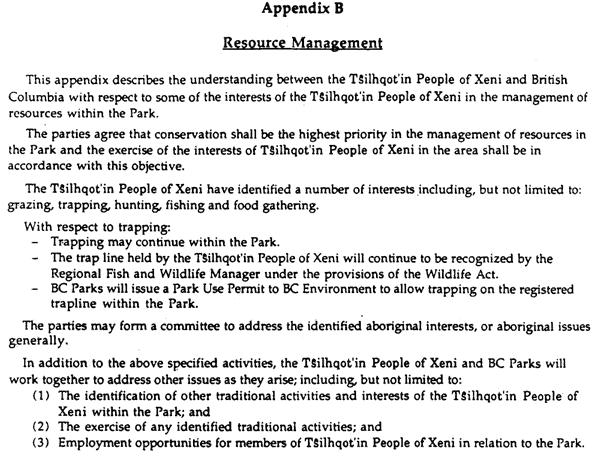
10 Ts'il?os GWA NEJEGWAGHATEN To enable the implementation of the Memorandum of Understanding, a committee of BC Parks and Xeni Gwet in representatives has been established. This committee is known as Ts'il?os Gwa Nejegwaghaten, which means people working together for Ts'il?os. Membership Ts'il?os Gwa Nejegwaghaten consists of BC Parks and Xeni Gwet in representatives and includes the Chief, Councillors and park liaison person for the Xeni Gwet in, and the District Manager, the park manager and the planner for BC Parks. Purpose The purpose of Ts'il?os Gwa Nejegwaghaten is to discuss issues of mutual concern. Matters to be addressed will also include, but not be limited to, the following: 1. implementing the specific commitment outlined in Appendix B of the Memorandum of Understanding, which includes: the identification of traditional activities and interests within the park including, but not restricted to, grazing, trapping, hunting, fishing and food gathering; the exercise of any identified traditional activities; employment opportunities for members of the Xeni Gwet in within the park. 2. coordinating and directing input into the Master Planning process, through: identification of sites of special spiritual-cultural significant to the Xeni Gwet in, including historic habitation and burial sites and management of these sites; development of a master Plan or other appropriate management plans, in consultation with the Local Advisory Group and the public; 3. implementing the Master Plan which includes: review and evaluation of Park Use Permits applications and existing tenures (such as leaseholds, grazing, trapping, guide outfitting). See Attachment 2 for proposed permit referral process: 104
11 development of annual management plans (AMPs) setting out the work to be done and how it is to be accomplished, including staffing requirements and budgets pertaining to the planning, operation and management of the park; selection and evaluation of staff and consultants (see Attachment 3 for proposed process); review and evaluation of all research projects, publications, cultural and interpretation communications. Meetings Ts'il?os Gwa Nejegwaghaten will meet quarterly, or as mutually convenient, in Williams Lake or in a Chilcotin location as decided upon by Ts'il?os Gwa Nejegwaghaten. Meeting Notes Discussions at meetings will be recorded in meeting notes. These are not intended to be a transcript but will summarize general topics discussed, recommendations and justification, tasks to be accomplished prior to next session, assignment of task responsibility and agenda items. Agenda Agenda will be developed from the meeting notes and from items raised by members of the Ts'il?os Gwa Nejegwaghaten. Decision Making Ts'il?os Gwa Nejegwaghaten will strive in a constructive and co-operative manner to achieve a consensus decision of the members. Where there is a dispute, the two parties may agree to obtain the services of a mediator or third party. BC Parks and Xeni Gwet in (Xeni people will make their own decisions if dispute cannot be solved by a mediator or third party). Review Xeni Gwet in and BC Parks are committed to work together in a spirit of cooperation, respect and friendship and to develop a long-term working relationship. Either party may suggest changes to improve and or enhance this relationship. Substantive changes to the terms of reference require thirty days written notice, for discussion purposes. If disagreement of changes occurs, dispute resolution will be pursued. 105
12 106
13 Attachment 1 See Appendix F 107
14 Attachment 2 PERMIT REFERRAL SYSTEM A. Permits approved in the Chilko Lake Study Team Report (approval of existing operations) 1. BC Parks to inform the Xeni Gwet in of permits to be issued. 2. Park Manager and Park Liaison Person to discuss and develop permit conditions. 3. Ts'il?os Gwa Nejegwaghaten to review and evaluate permits and meet with permittees, as needed. It is recognized by Ts'il?os Gwa Nejegwaghaten that extraordinary meetings may be required to meet with the permittees. B. Permits not covered under the Chilko Lake Study Team Report 1. Park Manager and Park Liaison Person to assess the new application as to compliance with Master Plan and its appropriateness as an activity in a wilderness park. 2. Park Manager and Park Liaison Person to discuss and develop permit conditions, as needed. 3. Ts'il?os Gwa Nejegwaghaten review and evaluate permit and meet with permittees. 108
15 Attachment 3 HIRING AND MANAGEMENT OF PARK RANGERS AND CONTRACTORS Representatives of Ts'il?os Gwa Nejegwaghaten will work together to determine the requirements for ranger staff and contractors. A. Ranger Staff (BC Parks employees) In the selection of ranger staff, representatives of Ts'il?os Gwa Nejegwaghaten will: recruit potential candidates short list, interview and select candidates jointly develop work plan BC Parks will consult with Xeni chief and Council on employee evaluation and disciplinary issues for Xeni Gwet in members employed or under contract with BC Parks. B. Contractors Representatives of Ts'il?os Gwa Nejegwaghaten will work together to: develop calls for proposals evaluate proposals and select successful contractor Ts'il?os Gwa Nejegwaghaten will be kept informed on the performance of the contractor through updates in regular meetings. 109
16 Appendix E BC Parks System Goals 110
17 BC Parks System Goals In the Park Act, BC Parks must: conserve significant and representative natural and cultural resources provide a wide variety of outdoor recreation opportunities. Conservation Within the conservation mandate, BC Parks has two goals: Goal 1 Goal 2 Protection of Representative Landscapes - To conserve British Columbia's natural diversity by protecting viable, representative examples of our different landscapes. Protection of Special Features - To protect British Columbia's key natural and cultural features, including outstanding examples of our wildlife, old-growth forests, waterfalls and cultural artifacts. Recreation Within the recreation mandate, BC Parks has four goals: Goal 1 Goal 2 Goal 3 Goal 4 Tourism Travel Routes - To provide park attractions and services which enhance tourism travel routes. Outdoor Recreation Holiday Destinations - To provide park attractions which serve as or improve key destinations for outdoor recreation holidays. Backcountry - To provide outstanding backcountry recreation opportunities throughout the province. Some sites may feature adventure tourism, while in other areas the wilderness would remain untouched. Local Recreation - To ensure access to local outdoor recreation opportunities for all residents of this province. 111
18 Appendix F Memorandum of Understanding between Xeni Gwet'in and Government of British Columbia 112
19 Memorandum of Understanding Between: The Nemiah Valley Indian Band (T Ŝ ilhqot in People of Xeni) (hereinafter referred to as T Ŝ ilhqot in People of Xeni) and Her Majesty The Queen In Right Of The Province Of British Columbia (hereinafter referred to as British Columbia ) Whereas British Columbia and the T Ŝ ilhqot in People of Xeni wish to create a Provincial Park (hereinafter referred to as the Park ) to protect in perpetuity the natural environment of the area known to First Nations people as T Ŝ ilhqot in Ts'il?os Gwenti in Nen and known to non-natives as Chilko Lake; And Whereas the T Ŝ ilhqot in People of Xeni and British Columbia recognize the wilderness character of the Chilko Lake area; And Whereas the T Ŝ ilhqot in People of Xeni assert that the Chilko Lake area is of spiritual, cultural and economic significance to them; And Whereas the purpose of British Columbia in establishing the Park is to protect in perpetuity the natural environment and resources of the Park for the use and enjoyment of all British Columbians, including those of the T Ŝ ilhqot in People of Xeni; And Whereas the T Ŝ ilhqot in People of Xeni and British Columbia share a common concern to protect the unique characteristics of the Chilko Lake area; It Is Therefore Agreed by the parties to use the following principles to guide development of the cooperative working relationship in the establishment of the Park, namely; 113
20 1. ESTABLISHMENT OF PARK 1.1 British Columbia shall, subject to the Lieutenant Governor-in-Council providing the appropriate Order-in-Council pursuant to section 5 of the Park Act (1979 R.S.B.C. c.309) establish the area described in Appendix A as Ts'il?os Park. 1.2 The establishment of the Park is without prejudice to any aboriginal rights and title that the T Ŝ ilhqot in People of Xeni may have. 2. PURPOSE 2.1 The purpose of British Columbia and the T Ŝ ilhqot in People of Xeni in drafting this memorandum is to be consistent with the recommendations of the Chilko Lake Study Team June 1993 Final Report, in relation to Zone 1 only. 3. MANAGEMENT OF PARK 3.1 Subject to any aboriginal rights that the T Ŝ ilhqot in People of Xeni may have, the management and administration of the Park shall be done under the auspices and authority of the Park Act and accompanying regulations. 3.2 Subject to conservation, British Columbia will endeavour to manage the resources of the Park in a manner consistent with the interests of the T Ŝ ilhqot in People of Xeni including those as written in Appendix B of this memorandum. 4. MUTUAL COMMITMENT 4.1 The parties will work together in the spirit of cooperation, respect and friendship, and welcome the opportunity to do so. 4.2 The parties will work together in the spirit of cooperation, respect and friendship, and welcome the opportunity to do so. 4.3 In matters pertaining to the Park, British Columbia and the T Ŝ ilhqot in People of Xeni will address issues of mutual interest in a manner consistent with a government-togovernment relationship. 4.4 The parties will work together to address funding issues as they arise. Financing for the implementation of any specific project or activity stemming from this agreement may be negotiated by the parties. Where appropriate, British Columbia will assist the T Ŝ ilhqot in People of Xeni in securing resources from other parties for specific projects. In witness whereof the parties hereto have executed this Memorandum of Understanding this 13 th day of January
21 115
22 116
23 117
24 118
25 119
26 Appendix G Zoning in BC Parks 120
27 Intensive Recreation Natural Environment OBJECTIVE To provide for a variety of readily accessible, facilityoriented outdoor recreation opportunities. To protect scenic values and to provide for backcountry recreation opportunities in a largely undisturbed natural environment. USE LEVEL Relatively high density and long duration types of use. Relatively low use but higher levels in association with nodes of activity or access. MEANS OF ACCESS All-weather public roads or other types of access where use levels are high (see "Impacts" below). Mechanized (power-boats, snowmobiles, all-terrain vehicles), non-mechanized (foot, horse, canoe, bicycle). Aircraft and motorboat access to dropoff and pickup points will be permitted. LOCATION Contiguous with all-weather roads and covering immediate areas, modified landscapes or other high-use areas. Removed from all-weather roads but easily accessible on a dayuse basis. Accessible by mechanized means such as boat or plane. SIZE OF ZONE Small; usually less than 2,000 ha. Can range from small to large. BOUNDARY DEFINITION RECREATION OPPORTUNITIES Includes areas of high facility development in concentrated areas. Vehicle camping, picnicking, beach activities, power-boating, canoeing, kayaking, strolling, historic and nature appreciation, fishing, snow play, downhill and cross-country skiing, snowshoeing, specialized activities. Boundaries should consider limits of activity/facility areas relative to ecosystem characteristics and features. Walk-in/boat-in camping, power-boating, hunting, canoeing, kayaking, backpacking, historic and nature appreciation, fishing, crosscountry skiing, snowmobiling, river rafting, horseback riding, heli-skiing, heli-hiking, and specialized activities. 121
28 Special Feature Wilderness Recreation Wilderness Conservation To protect and present significant natural or cultural resources, features or processes because of their special character, fragility and heritage values. Generally low. Various; may require special access permit. To protect a remote, undisturbed natural landscape and to provide backcountry recreation opportunities dependent on a pristine environment where air access may be permitted to designated sites. Very low use, to provide solitary experiences and a wilderness atmosphere. Use may be controlled to protect the environment. Non-mechanized; except may permit low frequency air access to designated sites; foot, canoe (horses may be permitted). To protect a remote, undisturbed natural landscape and to provide unassisted backcountry recreation opportunities dependent on a pristine environment where no motorized activities will be allowed. Very low use, to provide solitary experiences and a wilderness atmosphere. Use may be controlled to protect the environment. Non-mechanized (no air access); foot, canoe (horses may be permitted). Determined by location of special resources; may be surrounded by or next to any of the other zones. Remote; generally not visited on a day-use basis. Remote; not easily visited on a day-use basis. Small; usually less than 2000 hectares. Area defined by biophysical characteristics or the nature and extent of cultural resources (adequate to afford protection). Sight-seeing, historic and nature appreciation. May be subject to temporary closures or permanently restricted access. Large; greater than 5,000 ha. Defined by ecosystem limits and geographic features. Boundaries will encompass areas of visitor interest for specific activities supported by air access. Will be designated under the Park Act. Backpacking, canoeing, kayaking, river rafting, nature and historic appreciation, hunting, fishing, cross-country skiing, snowshoeing, horseback riding, specialized activities (e.g. caving, climbing). Large; greater than 5,000 ha. Defined by ecosystem limits and geographic features. Will be designated under the Park Act. Backpacking, canoeing, kayaking, river rafting, nature and historic appreciation, fishing, cross-country skiing, snowshoeing, horseback riding, specialized activities (e.g. caving, climbing). 122
29 Intensive Recreation Natural Environment FACILITIES IMPACTS ON NATURAL ENVIRONMENT MANAGEMENT GUIDELINES EXAMPLES OF ZONING May be intensely developed for user convenience. Campgrounds, landscaped picnic/play areas, trail, accommodation or interpretive buildings, boat launches; administrative buildings, service campgrounds, gravel pits, disposal sites, wood lots, parking lots, etc. Includes natural resource features and phenomena in a primarily natural state but where human presence may be readily visible both through the existence of recreation facilities and of people using the zone. Includes areas of high facility development with significant impact on concentrated areas. Oriented toward maintaining a high quality recreation experience. Intensive management of resource and/or control of visitor activities. Operational facilities designed for efficient operation while remaining unobtrusive to the park visitor. Campground in Rathtrevor Beach Park; Gibson Pass ski areas in E.C. Manning Park. Moderately developed for user convenience. Trails, walkin/boat-in campsites, shelters; accommodation buildings may be permitted; facilities for motorized access, e.g. docks, landing strips, fuel storage, etc. Area where human presence on the land is not normally visible, facility development limited to relatively small areas. Facilities are visually compatible with natural setting. Oriented to maintaining a natural environment and to providing a high quality recreation experience. Visitor access may be restricted to preserve the recreation experience or to limit impacts. Separation of less compatible recreational activities and transportation modes. Designation of transportation may be necessary to avoid potential conflicts (e.g. horse trails, cycle paths, hiking trails). Core area in Cathedral Park; North beach in Naikoon Park. 123
30 Special Feature Wilderness Recreation Wilderness Conservation Interpretive facilities only, resources are to be protected. Minimal facility development. Limited development for user convenience and safety, and protection of the environment, e.g. trails, primitive campsites, etc. Some basic facilities at access nodes, e.g. dock, primitive shelter, etc. None. None; resources to be maintained unimpaired. Natural area generally free of evidence of modern human beings. Evidence of human presence is confined to specific facility sites. Facilities are visually compatible with natural setting. Natural area generally free of evidence of modern human beings. High level of management protection with ongoing monitoring. Oriented to maintaining resources and, where appropriate, a high quality recreational and interpretive experience. Active or passive management depending on size, location, and nature of the resource. Visitor access may be restricted to preserve the recreation experience and to limit impacts. Oriented to protecting a pristine environment. Management actions are minimal and not evident. Managed to ensure low visitor use levels. Visitor access may be restricted to protect the natural environment and visitor experience. Oriented to protecting a pristine environment. Management actions are minimal and not evident. Managed to ensure low visitor use levels. Visitor access may be restricted to protect the natural environment and visitor experience. Tidepools in Botanical Beach Park; Sunshine Meadows in Mount Assiniboine Park. Quanchus Mountains Wilderness in Tweedsmuir Park; Wilderness Zone in Spatsizi Park. Central Valhallas Wilderness in Valhalla Park; Garibaldi Park Nature Conservancy area. 124
31 Appendix H Management Units 125
32 Introduction This section provides a description of the values, states key considerations based on geographic units, known as management units, and characterizes the management actions specific to that management unit. These management units serve to break up the larger zones into more manageable sizes. In defining a management unit, the Subcommittee looked at the values located there and the access to those values. These tables reflect the more detailed discussion that occurred amongst the Subcommittee as they were developing the plan. Some specific management directions were agreed to for certain management units and are recorded in these tables. Ts'il?os Provincial Park is divided into eight units: Tullin, Tsuniah, Ts'il?os; Yohetta/Tchaikazan; Lord River; Stikelan South; South Chilko Lake; North Chilko Lake (Figure 5). 126
33 127
34 Ts'il?os Unit Description includes northern portion of the park south of the Nemiah Valley and includes Mount Ts'il?os Long Valley. a small portion zoned Special Feature, around Mount Ts'il?os in recognition of its cultural and spiritual significance. remainder of Ts'il?os Unit is zoned Wilderness Recreation, in recognition of its natural values, remote backcountry recreation opportunities, and wilderness qualities. occupies approximately 15% of the park or 34,000 ha. Ecosystem Descriptors Cultural Descriptors food gathering sites graveyards Ts'il?os Outdoor Recreation Features Access Key Considerations - Conservation Key Considerations - Cultural Key Recreation Activities Other considerations Conservation Management contains Biogeoclimatic zones of Alpine Tundra, Engelmann Spruce - Subalpine Fir, Montane Spruce, Interior Douglas Fir. Ts'il?os area is a glaciated, rugged mountain ridge of more than 3000 metres with extensive dry alpine plant communities; deeply-incised gullies; alpine tarns. Long Valley is a heavily-wooded, high-elevation valley with highelevation (1,645 metres) wetlands. wildlife that occurs here includes: goat, sheep, mule deer, grizzly bear, black bear, moose, wolverine, wolf, marmot, lynx, martin, fisher, cougar, beaver. fish species that occur in this unit include Dolly Varden (bull trout). wetlands, including sedge fens and marshes draining to Chilko and Taseko Lakes. Rolling alpine ridges,ts'il?os, Dolly Lakes, Long Valley. No road in unit, access by routes on foot or on horse; by water in boat. No helicopter landing will be permitted in this unit in respect to the spirituality of the area to the Nemiah. Dolly Lake; dry alpine plant communities; meadows Ts'il?os ; traditional use sites; grave sites. Hiking, horse riding, guide outfitting, hunting, fishing, skiing, wildlife viewing, photography, nature study. Guide outfitters; grazing tenures; recreation guides. A bear management plan will be developed in collaboration with BC Environment to address potential bear and visitor conflicts. Bighorn sheep will be monitored closely to ensure a healthy population. Red and blue listed species will be monitored with BC Environment. Species plans for wildlife and fish will be developed where needed to 128
35 Cultural Management Recreation Management Other Management address population levels, habitat and harvest. All alpine lakes will be maintained in natural state. Barren lakes will not be stocked. An inventory and assessment of cultural resources will conducted in collaboration with Xeni Gwet'in. Management strategies for identified heritage sites will be developed. The climbing of peaks of Ts'il?os is not allowed. Education and interpretation for hikers and climbers is required. Education and information will be provided to park visitors on the significance of Ts'il?os and to respect the Xeni Gwet'in's wishes not to climb the mountain. Mountain biking is not allowed in this unit. No campgrounds will be developed in this unit, but basic facilities may be provided to protect the environment. Trails will be user-maintained. BC Parks will assist in trail maintenance problems. Backcountry conditions will be assessed and use monitored to protect the natural values. If impacts increase, Local Advisory Group will be consulted for application of appropriate management options. Horse use will be monitored and regulated as necessary to protect the environment. Information on established horse use and travel will be prepared to minimize conflict between users. A forage assessment will be undertaken in frequently used areas. Backcountry conditions will be assessed and use monitored to protect natural values. A backcountry management plan will set limits of use using indicators of acceptable impacts. Commercial helicopter access is not allowed except for emergencies. There are no designated landing sites in consideration of spiritual nature of the area. Fixed-wing access has no landing sites identified in this Unit, and therefore, is not allowed. Only licensed activities will be permitted to have snowmobile and ATV access. All other activities are prohibited. Existing guide outfitters, angle guides and trappers guides will be authorized by park use permit. BC Parks will work with BC Environment for any changes with angle guides and guide outfitters. Pre-existing historical backcountry recreation operators will be authorized by park use permit. Optimal number of user-days will be determined before issuing new permits. Quotas may be set for commercial guides and a limit set on public when monitoring shows the carrying capacity is close to being exceeded. Existing grazing permits will be managed by the Forest Service. BC Parks will work with the Forest Service to ensure that range 129
36 management plans are prepared, that livestock grazing is managed and monitored so that grazing and grassland communities are sustainable and damage is minimized. Grazing activity will not be expanded from the June 1991 allotted animal unit months. 130
37 Yohetta Tchaikazan Unit Description includes the central portion of the park east of Chilko Lake and encompasses the Yohetta Valley, Tchaikazan Valley, Mt. Goddard, Spectrum Pass. zoned Wilderness Recreation in recognition of its high recreation values in a remote backcountry setting and key conservation values. occupies approximately 20% of the park or 45,000 ha. Ecosystem Descriptors contains Biogeoclimatic zones of Alpine Tundra, Engelmann Spruce - Subalpine Fir, Montane Spruce, Interior Douglas Fir. wildlife that occurs here includes: goat, sheep, grizzly bear, mule deer, wolverine, martin, fisher, cougar, wolf, coyote. Tchaikazan - granitic peaks, glaciated valley, large and small glaciers, eroded peaks, broad outwash valley with braided river, fens, long alpine ridges, high passes, moraines. Yohetta - lakes and wetlands, east-west valley, mountainous ridges, aspen groves. Cultural Descriptors food gathering, hunting and fishing sites grave sites trapper's cabin Outdoor Recreation Features Access Key Considerations - Conservation Key Considerations - Cultural Key Recreation Activities Other considerations Conservation Management Tchaikazan Valley, Yohetta Valley, Yohetta Lake, Dorothy Lake, Rainbow Lake, alpine passes, glaciers. Roadless, relatively easy access by routes on foot or on horse from the Lord River Mining Road, from Chilko Lake via the Rainbow Creek trail. This area is also accessed by float plane, or by helicopter. Wetlands; Harlequin duck nesting habitat; alpine plant communities; sheep population, habitat and migration routes; grizzly population and habitat; mule deer population, habitat and migration routes; falcons; highelevation grasslands; lamb rearing areas. Traditional use sites; grave sites. Hiking, climbing, horse riding, guide outfitting, hunting, fishing, wildlife viewing, photography, ski touring, snowshoeing. Guide outfitters; grazing tenures; recreation guides; residential leases; trapping; helicopters. A bear management plan will be developed in collaboration with BC Environment to address potential bear and visitor conflicts. Bighorn sheep will be monitored closely to ensure a healthy population. Red and blue listed species will be monitored with BC Environment. Species plans for wildlife and fish will be developed where needed to address population levels, habitat and harvest. All alpine lakes will be maintained in natural state. Barren lakes will 131
38 Cultural Management Recreation Management Other Management not be stocked. The park's limited wetlands will be protected to maintain the natural environment and the diverse bird populations. An inventory and assessment of cultural resources will conducted in collaboration with Xeni Gwet'in. Management strategies for identified heritage sites will be developed. The Yohetta and Tchaikazan loop trail and trails to Rainbow Lake and Rainbow cabin will be maintained by BC Parks as primitive trails or routes. The rest of the trails will be user-maintained. BC Parks will assist in trail maintenance problems. Mountain biking is permitted in Yohetta as far as the west end of Yohetta Lake (Olson's cabin). Horses and hikers have priority. Motor boats are not allowed, given the backcountry setting. Long-term residential leaseholders will be given permit to operate motorboats for transportation only. Campgrounds will not be developed in this unit, but basic facilities may be provided to protect the environment. Horse use will be monitored and regulated as necessary to protect the environment. Information on established horse use and travel will be prepared to minimize conflict between users. A forage assessment will be undertaken in frequently used areas. Backcountry conditions will be assessed and use monitored to protect the natural values. A backcountry management plan will set limits of use using indicators of acceptable impacts. If impacts increase, Local Advisory Group will be consulted for application of appropriate management options. BC Parks will maintain close contact with the Local Advisory Group in the management of the Taseko Management Zone to ensure the resource development plans address aesthetics, recreation, conservation and wilderness values. Helicopter access and heli-assisted hiking may occur on a limited basis, taking into account wildlife and recreation values. Existing guide outfitters, angle guides and trappers will be authorized by park use permit. BC Parks will work with BC Environment for any changes with angle guides and guide outfitters. Only licensed activities will be permitted snowmobile and ATV access. All other activities are prohibited. Pre-existing historical backcountry recreation operators will be authorized by park use permit. Optimal number of user-days will be determined before issuing new permits. Quotas may be set for commercial guides and a limit set on public when monitoring shows the carrying capacity is close to being exceeded. Existing recreation and residential leases will be honoured as leases or park use permits. Leases and permits can be transferred to the immediate family. BC Parks will purchase improvements where 132
39 agreed to by both parties. Residential and recreational lease and permit holders can continue to access their cabins through usual means. Existing grazing permits will be managed by the Forest Service. BC Parks will work with the Forest Service to ensure that range management plans are prepared, that livestock grazing is managed and monitored so that grazing and grassland communities are sustainable and damage is minimized. Grazing activity will not be expanded from the June 1991 allotted animal unit months. 133
40 Lord River Unit Description is the most remote part of the park in the south east corner. It includes Lord River, various peaks and glaciers. zoned Wilderness Recreation, in recognition of its natural values, backcountry recreation opportunities, and wilderness qualities. occupies approximately 13% of the park or 31,000 ha. Ecosystem Descriptors contains Biogeoclimatic zones of Alpine Tundra, Engelmann Spruce - Subalpine Fir. wildlife that occurs here includes: goats, moose, bear, mule deer. steep-sided glacial valleys, rugged granitic peaks, large glaciers, moraine flats, slide paths, and large, swift glacial streams. Cultural Descriptors hunting areas gathering sites possible archeological and grave sites Outdoor Recreation Features Access Key Considerations - Conservation Key Considerations - Cultural Key Recreation Activities Other considerations Conservation Management Cultural Management Recreation Management Lord River, glaciers, mountains. Relatively difficult access; accessible by foot, canoe and helicopter. Wetlands, alpine areas. Traditional use sites Hiking, horse riding, guide outfitting, hunting, fishing, ski touring. Guide outfitters; recreation guides; helicopters. A bear management plan will be developed in collaboration with BC Environment to address potential bear and visitor conflicts. Red and blue listed species will be monitored with BC Environment. Species plans for wildlife and fish will be developed where needed to address population levels, habitat and harvest. All alpine lakes will be maintained in natural state. Barren lakes will not be stocked. The park's limited wetlands will be protected to maintain the natural environment and the diverse bird populations. An inventory and assessment of cultural resources will conducted in collaboration with Xeni Gwet'in. Management strategies for identified heritage sites will be developed. Small hiking groups are preferred in this unit. Information will be provided to hiking groups regarding the physical and social impacts of large groups in wilderness zones. 134
41 Description is the most remote part of the park in the south east corner. It includes Lord River, various peaks and glaciers. zoned Wilderness Recreation, in recognition of its natural values, backcountry recreation opportunities, and wilderness qualities. occupies approximately 13% of the park or 31,000 ha. Ecosystem Descriptors contains Biogeoclimatic zones of Alpine Tundra, Engelmann Spruce - Subalpine Fir. wildlife that occurs here includes: goats, moose, bear, mule deer. steep-sided glacial valleys, rugged granitic peaks, large glaciers, moraine flats, slide paths, and large, swift glacial streams. Cultural Descriptors hunting areas gathering sites possible archeological and grave sites Outdoor Recreation Features Lord River, glaciers, mountains. Trails will be user-maintained. BC Parks will assist in trail maintenance problems. Other Management Mountain biking is not allowed in this area. Backcountry conditions will be assessed and use monitored to protect the natural values. A backcountry management plan will set limits of use using indicators of acceptable impacts. If impacts increase, Local Advisory Group will be consulted for application of appropriate management options. Horse use will be monitored and regulated as necessary to protect the environment. Information on established horse use and travel will be prepared to minimize conflict between users. A forage assessment will be undertaken in frequently used areas. Motor boats are not allowed for this unit. Only licensed activities will be permitted snowmobile and ATV access. All other activities are prohibited. Helicopter access and heli-assisted hiking may occur on a limited basis, taking into account sensitive wildlife, recreation, and cultural or spiritual areas. Existing guide outfitters, angle guides and trappers will be authorized by park use permit. BC Parks will work with BC Environment for any changes with angle guides and guide outfitters. Pre-existing historical backcountry recreation operators will be authorized by park use permit. Optimal number of user-days will be determined before issuing new permits. Quotas may be set for commercial guides and a limit set on public when monitoring shows the carrying capacity is close to being exceeded. 135
42 Stikelan South Unit Description includes the southwest corner of the park, the west side of Edmond Creek, Franklyn Arm, the Capital Group. zoned Wilderness Recreation, in recognition of its natural values, backcountry recreation opportunities, and wilderness qualities. occupies approximately 36% of the park or 85,000 ha. Ecosystem Descriptors contains Biogeoclimatic zones of Alpine Tundra, Engelmann Spruce - Subalpine Fir, Montane Spruce, Interior Douglas Fir, coastal Western Hemlock. wildlife that occurs here includes: goats, grizzly bear, moose. extensive glaciation, exposed granitics, high-elevation lakes, rugged talus slopes, limited alpine meadows, steep subalpine slopes. Cultural Descriptors Grease trading trail to Bute Inlet from the end of Franklyn Arm. hunting areas. Outdoor Recreation Features Access Key Considerations - Conservation Key Considerations - Cultural Key Recreation Activities Other considerations Conservation Management Glaciated peaks, Girdwood and Glasgow Lakes, alpine lakes and meadows. Access by routes on foot or on horse; by boat. Marmot colonies, salt licks. Traditional gathering and hunting areas. Hiking, horse riding, guide outfitting, hunting, mountaineering. Guide outfitters; recreation guides; residential lease; trapping cabins; helicopters A bear management plan will be developed in collaboration with BC Environment to address potential bear and visitor conflicts. Red and blue listed species will be monitored with BC Environment. Species plans for wildlife and fish will be developed where needed to address population levels, habitat and harvest. All alpine lakes will be maintained in natural state. Barren lakes will not be stocked. The park's limited wetlands will be protected to maintain the natural environment and the diverse bird populations. 136
43 Cultural Management Recreation Management Other Management An inventory and assessment of cultural resources will conducted in collaboration with Xeni Gwet'in. Management strategies for identified heritage sites will be developed. Trails will be user-maintained. BC Parks will assist in trail maintenance problems. Mountain biking is not allowed in this area. Horse use will be monitored and regulated as necessary to protect the environment. Information on established horse use and travel will be prepared to minimize conflict between users. A forage assessment will be undertaken in frequently used areas. Backcountry conditions will be assess and use monitored to protect the natural values and the desired maximum level of visitors. A backcountry management plan will set limits of use using indicators of acceptable impacts. If impacts increase, Local Advisory Group will be consulted for application of appropriate management options. Sensitive alpine areas, such as Glasgow and Girdwood Lakes, will be assessed and monitored to ensure the ecological integrity of the area. Only licensed activities will be permitted snowmobile and ATV access. All other activities are prohibited. Existing guide outfitters, angle guides and trappers will be authorized by park use permit. BC Parks will work with BC Environment for any changes with angle guides and guide outfitters. Pre-existing historical backcountry recreation operators will be authorized by park use permit. Optimal number of user-days will be determined before issuing new permits. Quotas may be set for commercial guides and a limit set on public when monitoring shows the carrying capacity is close to being exceeded. Helicopter access and heli-assisted hiking may occur on a limited basis, taking into account sensitive wildlife, recreation, and cultural or spiritual areas. Existing recreation and residential leases will be honoured as leases or park use permits. Leases and permits can be transferred to the immediate family. BC Parks will purchase improvements where agreed to by both parties. Residential and recreational lease and permit holders can continue to access their cabins through usual means. 137
44 Tullin Unit Description includes the most northwest portion of the park, located west of the north end of Chilko Lake and encompasses the Tullin Mountain Trail. zoned primarily Wilderness Recreation, in recognition of its natural values, backcountry recreation opportunities, and wilderness qualities. a small portion (surrounding the trail up Tullin Mountain) zoned Natural Environment. This provides a transition from the North Chilko Intensive Recreation Zone to the Tullin Wilderness Recreation Zone. occupies approximately 5% of the park or 12,000 ha. Ecosystem Descriptors contains Biogeoclimatic zones of Alpine Tundra, Engelmann Spruce - Subalpine Fir, Montane Spruce, Interior Douglas Fir. wildlife that occurs here includes: grizzly bear, black bear, mule deer, moose, goats. Cultural Descriptors gathering areas hunting areas Outdoor Recreation Features Access Key Considerations - Conservation Key Considerations - Cultural Key Recreation Activities Other considerations Conservation Management Cultural Management Alpine ridges, Green Lake, viewscapes. Gravel road from Tatla Lake leads into park at North End campsite, access by routes on foot or on horse; by water in boat; and by helicopter. Alpine areas Traditional use sites Hiking, horse riding, guide outfitting, hunting, fishing, Guide outfitters; grazing tenures; recreation guides; helicopters. A bear management plan will be developed in collaboration with BC Environment to address potential bear and visitor conflicts. Red and blue listed species will be monitored with BC Environment. Species plans for wildlife and fish will be developed where needed to address population levels, habitat and harvest. All alpine lakes will be maintained in natural state. Barren lakes will not be stocked. An inventory and assessment of cultural resources will conducted in collaboration with Xeni Gwet'in. Management strategies for identified heritage sites will be developed. 138
45 Recreation Management Other Management The Tullin Trail will be maintained to a primitive standard; maintenance problems will be addressed. All other trails will be usermaintained. BC Parks will assist in trail maintenance problems. Education and informational materials will be developed and distributed to avoid conflicts between bears and people. Existing levels of use of paragliding is permitted. This activity will be assessed and monitored and may be restricted if becomes an aviation or safety hazard, or has a negative impact on wildlife (e.g. falcons). Mountain biking is allowed on roads. Information on etiquette and behaviour around horses will be prepared. Motor boats are not allowed on Green Lake. Backcountry conditions will be assess and use monitored to protect the natural values. If impacts increase, Local Advisory Group will be consulted for application of appropriate management options. Horse use will be monitored and regulated as necessary to protect the environment. Information on established horse use and travel will be prepared to minimize conflict between users. A forage assessment will be undertaken in frequently used areas. Only licensed activities will be permitted snowmobile and ATV access. All other activities are prohibited. Helicopter access and heli-assisted hiking may occur on a limited basis, taking into account sensitive wildlife, recreation, and cultural or spiritual areas. Existing guide outfitters, angle guides and trappers will be authorized by park use permit. BC Parks will work with BC Environment for any changes with angle guides and guide outfitters. Pre-existing historical backcountry recreation operators will be authorized by park use permit. Optimal number of user-days will be determined before issuing new permits. Quotas may be set for commercial guides and a limit set on public when monitoring shows the carrying capacity is close to being exceeded. Existing grazing permits will be managed by the Forest Service. BC Parks will work with the Forest Service to ensure that range management plans are prepared, that livestock grazing is managed and monitored so that grazing and grassland communities are sustainable and damage is minimized. Grazing activity will not be expanded from the June 1991 allotted animal unit months. BC Parks will work with the BC Forest Service, BC Environment and forest companies in the development of forest management guidelines for areas adjacent to the park. 139
46 Tsuniah Unit Description includes the most northeastern part of the park, east of Chilko Lake. protects viewscape from the North End campsite, and east side of the lake. zoned primarily Wilderness Recreation, in recognition of its natural values, backcountry recreation opportunities, and wilderness qualities. a small portion (the Tsuniah Lake Road) zoned Natural Environment. occupies approximately 3% of the park or 7,000 ha. Ecosystem Descriptors contains Biogeoclimatic zones of Alpine Tundra, Engelmann Spruce - Subalpine Fir, Montane Spruce, Interior Douglas Fir. wildlife that occurs here includes: goats, sheep, mule deer, moose, black bear, grizzly bear. Cultural Descriptors campsites medicinal gathering sites Outdoor Recreation Features Access Key Considerations - Conservation Key Considerations - Cultural Key Recreation Activities Other considerations Conservation Management Alpine ridges, Douglas-fir stands. Rough road bisects the unit, additional access by foot or horse. Little Lagoon, old-growth forests, alpine areas, sheep range and migratory routes, Tsuniah Creek. Traditional use sites Hiking, horse riding, guide outfitting, hunting. Guide outfitters; grazing tenures; recreation guides; residential leases; trapline. A bear management plan will be developed in collaboration with BC Environment to address potential bear and visitor conflicts. Red and blue listed species will be monitored with BC Environment. Species plans for wildlife and fish will be developed where needed to address population levels, habitat and harvest. All alpine lakes will be maintained in natural state. Barren lakes will not be stocked. Sensitive areas, such as old-growth forests and Little Lagoon, will be assessed and monitored to ensure that use does not impact the ecological integrity of the area. Douglas-fir stands require fire management plan. 140
47 Cultural Management Recreation Management Other Management An inventory and assessment of cultural resources will conducted in collaboration with Xeni Gwet'in. Management strategies for identified heritage sites will be developed. Trails will be user-maintained. BC Parks will assist in trail maintenance problems. Backcountry conditions will be assessed and use monitored to protect the natural values. If impacts increase, Local Advisory Group will be consulted for application of appropriate management options. Horse use will be monitored and regulated as necessary to protect the environment. Information on established horse use and travel will be prepared to minimize conflict between users. A forage assessment will be undertaken in frequently used areas. Mountain biking is allowed on existing roads. No vehicular camping is allowed along Tsuniah Lake Road; day use only. Assess conditions and monitor site degradation and disposal of human wastes; if the impact is noticeable, refer to Local Advisory Group for appropriate management options. Day use areas will be monitored for garbage and human wastes disposal. If impacts are noticeable, seek advice from Local Advisory Group on appropriate management options. Only licensed activities will be permitted snowmobile and ATV access. All other activities are prohibited. Existing guide outfitters, angle guides and trappers will be authorized by park use permit. BC Parks will work with BC Environment for any changes with angle guides and guide outfitters. Pre-existing historical backcountry recreation operators will be authorized by park use permit. Optimal number of user-days will be determined before issuing new permits. Quotas may be set for commercial guides and a limit set on public when monitoring shows the carrying capacity is close to being exceeded. Backcountry conditions will be assessed and use monitored to develop baseline data with which to assess the desired maximum level of visitors. A backcountry management plan will set limits of use using indicators of acceptable impacts. Management of Department of Fisheries and Oceans' spawning channel is required to address off-road vehicle activity. 141
48 BC Parks will work with the Gwa Najegwaghaten, local residents and Local Advisory Group to establish levels of maintenance to keep the road in a rough but passable condition. If and when an alternative to the Tsuniah Lake Road is developed, investigate opportunities to limit access to the Tsuniah Lake Road. Work with government agencies, such as Ministry of Transportation and Highways and Ministry of Forests, and the Xeni Gwet'in to maintain roads approaching the park in a manner which is consistent with wilderness aspects of the park. New roads should not be considered. Helicopter access and heli-assisted hiking may occur on a limited basis, taking into account sensitive wildlife, recreation, and cultural or spiritual areas. Existing recreation and residential leases will be honoured as leases or park use permits. Leases and permits can be transferred to the immediate family. BC Parks will purchase improvements where agreed to by both parties. Residential and recreational lease and permit holders can continue to access their cabins through usual means. Existing grazing permits will be managed by the Forest Service. BC Parks will work with the Forest Service to ensure that range management plans are prepared, that livestock grazing is managed and monitored so that grazing and grassland communities are sustainable and damage is minimized. Grazing activity will not be expanded from the June 1991 allotted animal unit months. Work with the BC Forest Service, BC Environment and forest companies in the development of forest management guidelines for areas adjacent to the park. 142
49 North Chilko Lake Unit Description includes the lake from the outlet to the Chilko River to just south of the Nemiah Valley campsite (or Movie Site) and Duff Island. Includes both campsites, the shoreline and the area accessed by water. small areas (Big Lagoon and The Point) zoned as Special Features in recognition of conservation values. smaller portions in the immediate vicinity of the campsites zoned Intensive Recreation, to provide a camping destination. lake zoned Natural Environment in recognition that the use of motor boats for safety reasons may preclude a sense of a wilderness recreation opportunity at times. shoreline zoned Wilderness Recreation in recognition of natural and conservation values, backcountry recreation opportunities and wilderness qualities. occupies approximately 3% of the park or 7,000 ha. Ecosystem Descriptors large high-elevation nutrient-deficient lake deep and cold with lake stratifying in mid to late summer rapid flushing rates tributaries riparian areas lagoons spawning beaches and streams wildlife that occurs here: grizzly bears, black bears, moose, mule deer. fish that occur here: bull trout, rainbow trout, kokanee salmon, whitefish, sockeye salmon. Cultural Descriptors food gathering areas hunting areas campsites Outdoor Recreation Features Access Key Considerations - Conservation Key Considerations - Cultural Key Recreation Activities Other considerations Conservation Management Chilko Lake, Big Lagoon, Duff Island, mountain scenery. Gravel roads at both North End campsite and Movie site; formal boat launch at the North End campsite and informal launch for small boats at the Movie site. Big Lagoon; salmon spawning and rearing. Traditional use sites; camping areas. Boating, fishing, kayaking, canoeing, day hiking, destination camping, backcountry staging area. Recreation guides A bear management plan will be developed in collaboration with BC Environment to address potential bear and visitor conflicts. Red and blue listed species will be monitored with BC Environment. Species plans for wildlife and fish will be developed where needed to address population levels, habitat and harvest. Migratory fish habitat, particularly spawning beaches, will be protected and managed in cooperation with Department of Fisheries and Oceans. 143
50 BC Parks will work with BC Environment and the Department of Fisheries and Oceans and operators to monitor and assess impact on fishing pressure to ensure natural fish populations are maintained. The fertilization program will be reviewed with Department of Fisheries and Oceans and BC Environment. Any continuation of the program will be discussed with the Xeni Gwet'in and the Local Advisory Group. An aquatic resources inventory plan will be developed in conjunction with Department of Fisheries and Oceans and BC Environment to gain a better understanding of resources, impacts of angling and harvesting, and implications for populations outside the park. Cultural Management Recreation Management An inventory and assessment of cultural resources will conducted in collaboration with Xeni Gwet'in. Management strategies for identified heritage sites will be developed, particularly near campsites. Heritage impact assessments will be undertaken prior to any development, particularly near the campsites. The names of the campgrounds will be changed to reflect the natural and cultural history of the area, in consultation with the Xeni and the Local Advisory Group. Horse use will be monitored and regulated as necessary to protect the environment. Information on established horse use and travel will be prepared to minimize conflict between users. A forage assessment will be undertaken in frequently used areas. Mountain biking is allowed on existing roads and designated trails. Assessment and monitoring may be required. Campsites and long-term parking will be redeveloped to maintain aesthetics and provide basic facilities; current level of camping and docking will be maintained. Development plan will be reviewed with Gwa Najegwaghaten and the Local Advisory Group. Motor-boating is allowed on Chilko Lake, but motor use on Big Lagoon and Little Lagoon is not allowed. On Big Lagoon, guide outfitters will be allowed to use motors to transport supplies. Consider restrictions on horsepower and type of motor to protect wildlife and for public safety. Level of use by motor boats will be monitored. Boat launching facilities at the North End will be maintained. Boats can be launched at the Movie Site, but facilities will not be developed. Houseboats will be monitored and levels of use established according to available campsites and moorage while considering other users such as power boaters, kayakers, and wilderness seekers. BC Parks will work with operator to ensure sewage disposal facilities meet provincial health regulations. Monitor visitor attendance and satisfaction to determine future development. To avoid bear-people conflicts, undertake preventative measures such as signing, evacuations or closures of the campsite(s) if bears are active in the area. Prepare and provide information on fishing regulations at the two campsites, the dangers of Chilko Lake, importance of Big Lagoon (Moose Lagoon) to prevent harassment of wildlife and damage to vegetation, boating etiquette and wilderness ethics, avoid conflicts between bears and people. 144
51 Commercial rafting use will continue. Personal watercraft (e.g., Jet ski, Seadoo) use will be monitored. If boating regulations change to separate personal watercraft from other boats, BC Parks will pursue eliminating use of personal watercraft from park. Informal campsites used by boaters will be assessed and monitored for site degradation, human waste disposal and garbage. If impact is detected, the Local Advisory Group will be consulted for advice on appropriate management options that are consistent with wilderness character. Only minimal facility development will be undertaken when needed. No campgrounds will be developed in this unit, but basic facilities may be provided to protect the environment. Park facilities will be planned in consultation with the communities of North Chilko and Nemiah Valley so that facilities will be in keeping with the character of the area and blend with the natural setting. Other Management Only licensed activities will be permitted snowmobile and ATV access. All other activities are prohibited. Existing guide outfitters, angle guides and trappers guides will be authorized by park use permit. BC Parks will work with BC Environment for any changes with angle guides and guide outfitters. Pre-existing historical backcountry recreation operators will be authorized by park use permit. Optimal number of user-days will be determined before issuing new permits. Quotas may be set for commercial guides and a limit set on public when monitoring shows the carrying capacity is close to being exceeded. Backcountry conditions will be assessed and use monitored to develop baseline data with which to assess the desired maximum level of visitors. A backcountry management plan will set limits of use using indicators of acceptable impacts. Helicopter access and heli-assisted hiking may occur on a limited basis. Existing grazing permits will be managed by the Forest Service. BC Parks will work with the Forest Service to ensure that range management plans are prepared, that livestock grazing is managed and monitored so that grazing and grassland communities are sustainable and damage is minimized. Grazing activity will not be expanded from the June 1991 allotted animal unit months. 145
52 South Chilko Lake Unit Description the most southerly extent of the lake. Includes the shoreline and the areas accessed by water. lake zoned Natural Environment in recognition of the need to use power boats, given the scale and danger of sudden winds. shoreline zoned Wilderness Recreation in recognition of natural and conservation values, backcountry recreation opportunities and wilderness qualities. occupies approximately 5% of the park or 12,000 ha. Ecosystem Descriptors large high-elevation nutrient-deficient lake deep and cold with lake stratifying in mid to late summer rapid flushing rates tributaries riparian areas spawning beaches and streams wildlife that occurs here: grizzly bears, black bears, moose, mule deer. fish that occur here: bull trout, rainbow trout, kokanee salmon, sockeye salmon, whitefish. Cultural Descriptors fishing and food gathering areas Outdoor Recreation Features Access Key Considerations - Conservation Key Considerations - Cultural Key Recreation Activities Other considerations Conservation Management Chilko Lake, Norrington Creek, Farrow Creek, Franklyn Arm, Bateman Island, Burnt Island, Capital Group, Edmond Creek, sandy beaches, mountain scenery, public cabin at Rainbow Creek. Gravel roads at both North End campsite and Movie site; formal launching facilities at North End and informal launching for small boats at Movie site. Salmon spawning beaches Traditional use sites Access to backcountry hiking, backpacking, and mountaineering, boating, fishing, kayaking, canoeing. Recreation guides, access to residential lease. A bear management plan will be developed in collaboration with BC Environment to address potential bear and visitor conflicts. Red and blue listed species, such as bull trout, will be monitored with BC Environment. Species plans for wildlife and fish will be developed where needed to address population levels, habitat and harvest. Migratory fish habitat, particularly spawning beaches, will be protected and cooperatively managed with Department of Fisheries and Oceans,and BC Environment. The fertilization program will be assessed with Department of Fisheries and Oceans and BC Environment. Any continuation of the program will be discussed with the Xeni Gwet'in and the Local Advisory Group. An aquatic resources inventory plan will be developed in conjunction with Department of Fisheries and Oceans and BC Environment to gain a 146
53 better understanding of resources, impacts of angling and harvesting, and implications for populations outside the park. Cultural Management Recreation Management An inventory and assessment of cultural resources will conducted in collaboration with Xeni Gwet'in. Management strategies for identified heritage sites will be developed. Mountain biking is not allowed in this area. Trails will be user-maintained. BC Parks will assist in trail maintenance problems. Backcountry conditions will be assess and use monitored to protect the natural values. If impacts increase, Local Advisory Group will be consulted for application of appropriate management options. Horse use will be monitored and regulated as necessary to protect the environment. Information on established horse use and travel will be prepared to minimize conflict between users. A forage assessment will be undertaken in frequently used areas. Guidelines for public use of Rainbow Cabin will be developed. Levels of use by motor boats will be monitored. Information will be developed for the safety of canoeists and kayakers, boating etiquette and wilderness ethics. Houseboats will be monitored and levels of use established according to available campsites and moorage while considering other users such as power boaters, kayakers, and wilderness seekers. BC Parks will work with operators to ensure sewage disposal facilities meet provincial health regulations. Angling pressures will be assessed and monitored in conjunction with BC Environment and Department of Fisheries and Oceans to ensure natural fish populations are maintained. Personal watercraft (e.g., Jet ski, Seadoo) use will be monitored. If boating regulations change to separate personal watercraft from other boats, BC Parks will pursue eliminating use of personal watercraft from park. Informal campsites used by boaters will be assessed and monitored for site degradation, human waste disposal and garbage. If impact is detected, the Local Advisory Group will be consulted for advice on appropriate management options that are consistent with wilderness character. Only minimal facility development will be undertaken when needed. No campgrounds will be developed in this unit, but basic facilities may be provided to protect the environment. Only licensed activities will be permitted snowmobile and ATV access. All other activities are prohibited. Existing guide outfitters, angle guides and trappers will be authorized by park use permit. BC Parks will work with BC Environment for any changes with angle guides and guide outfitters. Pre-existing historical backcountry recreation operators will be 147
54 authorized by park use permit. Optimal number of user-days will be determined before issuing new permits. Quotas may be set for commercial guides and a limit set on public when monitoring shows the carrying capacity is close to being exceeded. Existing recreation and residential leases will be honoured as leases or park use permits. Leases and permits can be transferred to the immediate family. BC Parks will purchase improvements where agreed to by both parties. Residential and recreational lease and permit holders can continue to access their cabins through usual means. 148
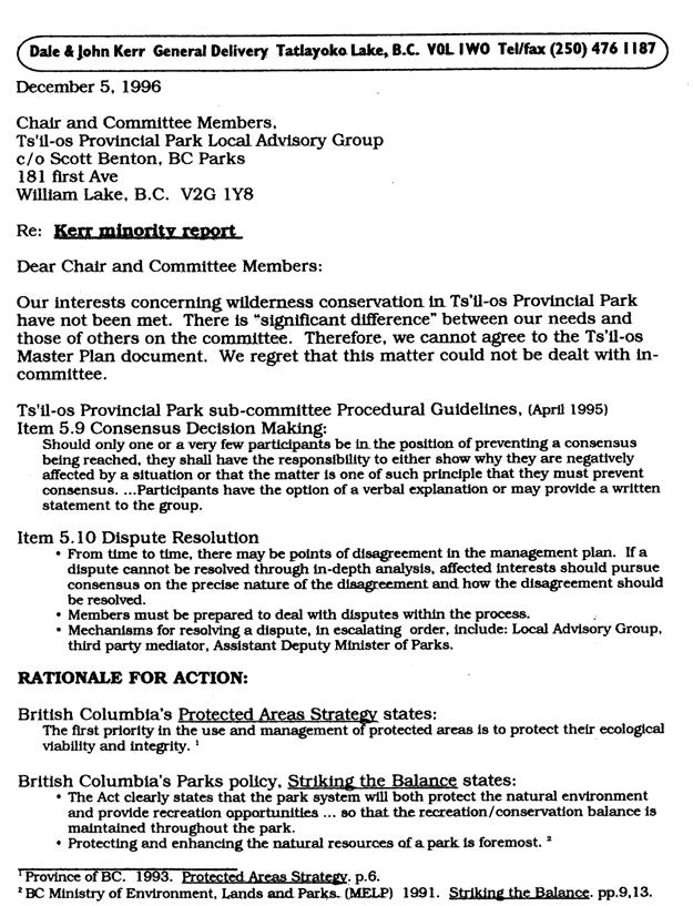
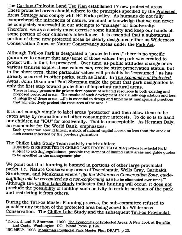
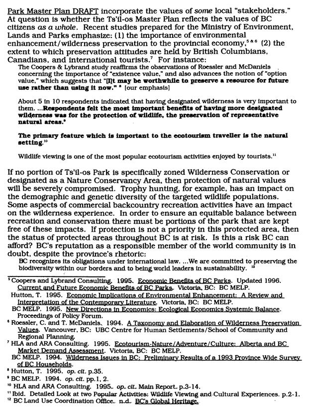
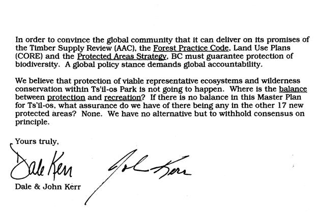
55 Appendix I Minority Report 149
56 150
57 151
58 152
59 153
Appendix A BC Provincial Parks System Goals
 Appendix A BC Provincial Parks System Goals The British Columbia Provincial Parks System has two mandates: To conserve significant and representative natural and cultural resources To provide a wide variety
As outlined in the Tatshenshini-Alsek Park Management Agreement, park management will:
 Management Strategy General Strategy The priority management focus for the park is to ensure that its internationally significant natural, cultural heritage and recreational values are protected and that
2.0 PARK VISION AND ROLES
 2.0 PARK VISION AND ROLES 2.1 Significance in the Protected Area System Marble Range and Edge Hills provincial parks protect 6.8% of the Pavillion Ranges Ecosection, which is located in the Southern Interior
Fred Antoine Park. Management Plan. Final Public Review Draft
 Fred Antoine Park Management Plan Final Public Review Draft March 2016 Fred Antoine Park Management Plan Approved by: Jeff Leahy Regional Director Thompson Cariboo Region BC Parks Date Brian Bawtinheimer
MANAGEMENT DIRECTION STATEMENT June, 1999
 Thompson River District MANAGEMENT DIRECTION STATEMENT June, 1999 for Roche Lake Provincial Park Ministry of Environment Lands and Parks BC Parks Division Table of Contents I. Introduction A. Setting
MANAGEMENT DIRECTION STATEMENT June, 1999
 Thompson River District MANAGEMENT DIRECTION STATEMENT June, 1999 for Clearwater River Corridor (Addition to Wells Gray Park) Ministry of Environment Lands and Parks BC Parks Division ii Table of Contents
5.0 OUTDOOR RECREATION OPPORTUNITIES AND MANAGEMENT
 5.0 OUTDOOR RECREATION OPPORTUNITIES AND MANAGEMENT 5.1 Introduction This section describes the range of recreational activities that currently take place in Marble Range and Edge Hills Parks, as well
Yard Creek Provincial Park. Management Plan
 Yard Creek Provincial Park Management Plan Draft January 2010 Yard Creek Provincial Park Management Plan Approved by: telàlsemkin/siyam/chief Scott Benton Bill Williams Squamish Executive Director ation
ANAGEMENT P LAN. February, for Elk Lakes and Height of the Rockies Provincial Parks. Ministry of Environment, Lands and Parks BC Parks Division
 M ANAGEMENT P LAN February, 1999 for Elk Lakes and Height of the Rockies Provincial Parks Ministry of Environment, Lands and Parks BC Parks Division Elk Lakes & Height of the Rockies Provincial Parks M
Bridge River Delta Park. Management Plan. Final Public Review Draft
 Bridge River Delta Park Management Plan Final Public Review Draft March 2016 Bridge River Delta Park Management Plan Approved by: Jeff Leahy Regional Director Thompson Cariboo Region BC Parks Date Brian
Role of the Protected Area
 Role of the Protected Area Provincial and Regional Context Height of the Rockies and Elk Lakes provincial parks lie in southeastern British Columbia in the Rocky Mountains, about 85 km southwest of Calgary,
Outdoor Recreation Opportunities Management
 Outdoor Recreation Opportunities Management Introduction The natural features of Height of the Rockies and Elk Lakes provincial parks provide a wide variety of outdoor recreational activities. However,
Kwadacha Wilderness Provincial Park and Kwadacha Addition (Kwadacha Recreation Area) Purpose Statement and Zoning Plan
 Purpose Statement and Zoning Plan") Kwadacha Wilderness Provincial Park and Kwadacha Addition (Kwadacha Recreation Area) Purpose Statement and Zoning Plan Located in a remote area of the northern interior of BC, this large park straddles
Kwadacha Wilderness Provincial Park and Kwadacha Addition (Kwadacha Recreation Area) Purpose Statement and Zoning Plan Located in a remote area of the northern interior of BC, this large park straddles
STONE MOUNTAIN PROVINCIAL PARK Purpose Statement and Zoning Plan
 1 STONE MOUNTAIN PROVINCIAL PARK Purpose Statement and Zoning Plan Stone Mountain Provincial Park is situated 140 km west of Fort Nelson at Kilometre 595 of the Alaska Highway. The 25 690 ha park is located
Pillar Park. Management Plan
 Pillar Park Management Plan January 2014 Pillar Park Management Plan Approved by: Jeff Leahy Regional Director Thompson Cariboo Region BC Parks January 9, 2014 Date Brian Bawtinheimer Executive Director
APPENDIX. Alberta Land Stewardship Act AMENDMENTS TO THE SOUTH SASKATCHEWAN REGIONAL PLAN
 APPENDIX Alberta Land Stewardship Act AMENDMENTS TO THE SOUTH SASKATCHEWAN REGIONAL PLAN 1 All references to Alberta Environment and Sustainable Resource Development, Environment and Sustainable Resource
PROUDLY BRINGING YOU CANADA AT ITS BEST. Management Planning Program NEWSLETTER #1 OCTOBER, 2000
 PROUDLY BRINGING YOU CANADA AT ITS BEST VUNTUT NATIONAL PARK Management Planning Program NEWSLETTER #1 OCTOBER, 2000 INTRODUCTION This newsletter launches the development of the first management plan for
FINGER-TATUK PROVINCIAL PARK
 FINGER-TATUK PROVINCIAL PARK PURPOSE STATEMENT AND ZONING PLAN March 2003 FINGER-TATUK PROVINCIAL PARK Purpose Statement and Zoning Plan Finger-Tatuk Provincial Park is 17,151 ha in size. It includes the
Restore and implement protected status that is equivalent, or better than what was lost during the mid-1990 s
 THE ROSSLAND RANGE, OLD GLORY AREA. Executive summary. The Friends of the Rossland Range Society, on behalf of the local outdoor community, seeks to accomplish the following with respect to the Old Glory
Continental Divide National Scenic Trail Legislative History and Planning Guidance
 Continental Divide National Scenic Trail Legislative History and Planning Guidance Legislation, Policy, and Direction Regarding National Scenic Trails The National Trails System Act, P.L. 90-543, was passed
MANAGEMENT DIRECTION STATEMENT March 2003
 Skeena Region MAAGEMET DIRECTIO STATEMET March 2003 for Great Glacier Provincial Park Ministry of Water, Land an Air Protection Environmental Stewardship Division ii This management direction statement
BIGHORN BACKCOUNTRY ACCESS MANAGEMENT PLAN
 BIGHORN BACKCOUNTRY ACCESS MANAGEMENT PLAN October, 2002 SPECTACULAR BY NATURE BIGHORN BACKCOUNTRY Alberta s Bighorn Backcountry offers spectacular Rocky Mountain scenery and unforgettable recreational
Wilderness Areas Designated by the White Pine County bill
 Wilderness Areas Designated by the White Pine County bill SEC. 321. SHORT TITLE. This subtitle may be cited as the `Pam White Wilderness Act of 2006'. SEC. 322. FINDINGS. Congress finds that-- The White
Watchorn Provincial Park. Management Plan
 Watchorn Provincial Park Management Plan 2 Watchorn Provincial Park Table of Contents 1. Introduction... 3 2. Park History... 3 3. Park Attributes... 3 3.1 Natural... 4 3.2 Recreational... 4 3.3 Additional
Mackinnon Esker Ecological Reserve Draft - Management Plan
 Mackinnon Esker Ecological Reserve Draft - Management Plan May 2011 Photo Credit: This document replaces the direction provided in the Carp Lake Provincial Park and Protected Area and Mackinnon Esker Ecological
FILE: /PERM EFFECTIVE DATE: May 16, 2014 AMENDMENT:
 APPROVED AMENDMENTS: Effective Date Briefing Note /Approval Summary of Changes: FILE: 11000-00/PERM EFFECTIVE DATE: May 16, 2014 AMENDMENT: Table of Contents 1. POLICY APPLICATION... 1 2. PRINCIPLES AND
National Wilderness Steering Committee
 National Wilderness Steering Committee Guidance White Paper Number 1 Issue: Cultural Resources and Wilderness Date: November 30, 2002 Introduction to the Issue Two of the purposes of the National Wilderness
Stuart River Provincial Park Purpose Statement and Zoning Plan
 Stuart River Provincial Park Purpose Statement and Zoning Plan Stuart River Provincial Park protects three-quarters of the 110 kilometer long Stuart River corridor between Stuart Lake and the Nechako River.
MANAGEMENT DIRECTION STATEMENT March 2003
 Skeena Region MAAGEMET DIRECTIO STATEMET March 2003 for Meziadin Lake Provincial Park Ministry of Water, Land and Air Protection Environmental Stewardsh Division This page left blank on purpose ii Table
OMINEACA PROVINCIAL PARK
 OMINEACA PROVINCIAL PARK AND PROTECTED AREA PURPOSE STATEMENT AND ZONING PLAN March 2003 OMINECA PROVINCIAL PARK AND PROTECTED AREA Purpose Statement and Zoning Plan Omineca Park and Omineca Protected
Clearwater Lake Provincial Park. Draft Management Plan
 Clearwater Lake Provincial Park Draft Management Plan Clearwater Lake Provincial Park Draft Management Plan Table of Contents 1. Introduction... 3 2. Park History... 4 3. Park Attributes... 4 3.1 Location/Access...4
ANAGEMENT P LAN. July for Chilliwack Lake Park & Chilliwack River Ecological Reserve. Ministry of Environment, Lands and Parks BC Parks Division
 M ANAGEMENT P LAN July 2000 for Chilliwack Lake Park & Chilliwack River Ecological Reserve Ministry of Environment, Lands and Parks BC Parks Division Chilliwack Lake Provincial Park & Chilliwack River
MANAGEMENT DIRECTION STATEMENT
 Skeena District MAAGEMET DIRECTIO STATEMET August 2000 for Driftwood Extension to Babine Mountains Park Ministry of Environment Lands and Parks BC Parks Division This management direction statement was
A GUIDE TO MANITOBA PROTECTED AREAS & LANDS PROTECTION
 A GUIDE TO MANITOBA PROTECTED AREAS & LANDS PROTECTION Manitoba Wildands December 2008 Discussions about the establishment of protected lands need to be clear about the definition of protection. We will
Appendix 1: Best Management Practices For Hang Gliding and Paragliding in Jasper National Parks
 Appendix 1: Best Management Practices For Hang Gliding and Paragliding in Jasper National Parks Name of Best Management Practice Best Management Practices for Hang Gliding and Paragliding in Jasper National
Flow Stand Up Paddle Board Parkway Plan Analysis
 Regional Parks Department Jeffrey R. Leatherman, Director County of Sacramento Divisions Administration Golf Leisure Services Maintenance Rangers Therapeutic Recreation Services Flow Stand Up Paddle Board
Dragon Mountain Park. Management Plan. Public Review Draft
 Disclaimer: This draft management plan contains preliminary proposals that are subject to change and therefore may not necessarily reflect the position of the Ministry of Environment. At the conclusion
SUGARBOWL-GRIZZLY DEN PROVINCIAL PARK AND SUGARBOWL-GRIZZLY DEN PROTECTED AREA Purpose Statement and Zoning Plan
 SUGARBOWL-GRIZZLY DEN PROVINCIAL PARK AND SUGARBOWL-GRIZZLY DEN PROTECTED AREA Purpose Statement and Zoning Plan Located one hour east of Prince George on Highway 16, Sugarbowl-Grizzly Den Provincial Park
MANAGEMENT DIRECTION STATEMENT
 Lower Mainland District MAAGEMET DIRECTIO STATEMET January 2001 for Liumchen Ecological Reserve Ministry of Environment Lands and Parks BC Parks Division Table of Contents Page Introduction... 1 Purpose
MARBLE RIVER PROVINCIAL PARK
 MARBLE RIVER PROVINCIAL PARK PURPOSE STATEMENT AND ZONING PLAN March 2003 MARBLE RIVER PROVINCIAL PARK Purpose Statement and Zoning Plan Primary Role The primary role of Marble River Park is to protect
D IRECTION S TATEMENT
 Vancouver Island Region M ANAGEMENT D IRECTION S TATEMENT September 2003 for Lower Nimpkish Provincial Park Ministry of Water, Land and Air Protection Environmental Stewardship Lower Nimpkish Provincial
ANAGEMENT. LAN November, 1996
 M ANAGEMENT P LAN November, 1996 for Paul Lake Provincial Park Ministry of Environment, Lands and Parks BC Parks Department Paul Lake Provincial Park M ANAGEMENT P LAN Prepared by BC Parks Kamloops Area
Numaykoos Lake Provincial Park. Management Plan
 Numaykoos Lake Provincial Park Management Plan 2 Numaykoos Lake Provincial Park Table of Contents 1. Introduction... 3 2. Background... 3 3. Park Purpose... 5 4. Park Management Guidelines... 6 Appendix...
Little Limestone Lake Provincial Park. Draft Management Plan
 Little Limestone Lake Provincial Park Draft Management Plan Little Limestone Lake Provincial Park Draft Management Plan Table of Contents 1. Introduction... 3 2. Background... 3 3. Planning context...
April 10, Mark Stiles San Juan Public Lands Center Manager 15 Burnett Court Durango, CO Dear Mark,
 Mark Stiles San Juan Public Lands Center Manager 15 Burnett Court Durango, CO 81301 Dear Mark, We are pleased to offer the following comments on the draft San Juan Public Lands Center management plans
Marchand Provincial Park. Management Plan
 Marchand Provincial Park Management Plan 2 Marchand Provincial Park Table of Contents 1. Introduction... 3 2. Park History... 3 3. Park Attributes... 4 3.1 Natural... 4 3.2 Recreational... 4 3.3 Additional
MANAGEMENT DIRECTION STATEMENT
 Skeena District MAAGEMET DIRECTIO STATEMET July, 2000 for Driftwood Canyon Provincial Park Ministry of Environment Lands and Parks BC Parks Division i Table of Contents Driftwood Canyon Park Approvals
Wallace Lake Provincial Park. Management Plan
 Wallace Lake Provincial Park Management Plan 2 Wallace Lake Provincial Park Table of Contents 1. Introduction... 3 2. Park History... 3 3. Park Attributes... 4 3.1 Natural... 4 3.2 Recreational... 4 4.
Sand Lakes Provincial Park. Draft Management Plan
 Sand Lakes Provincial Park Draft Management Plan 2 Sand Lakes Provincial Park Table of Contents 1. Introduction... 3 2. Background... 3 3. Park Purpose... 5 4. Park Management Guidelines... 6 Appendix...
Whitefish Range Partnership Tentatively Approved by WRP 11/18/2013!Rec. Wilderness Page 1
 Whitefish Range Partnership Tentatively Approved by WRP 11/18/2013!Rec. Wilderness Page 1 Recommended Wilderness Background The Whitefish Range has a long management and legislative history associated
Mackinnon Esker Ecological Reserve. Management Plan
 Mackinnon Esker Ecological Reserve Management Plan March 2017 Cover Page Photo Credit: Rob Bell This document replaces the direction provided in the Carp Lake Provincial Park and Protected Area and Mackinnon
KANANASKIS COUNTRY PROVINCIAL RECREATION AREAS MANAGEMENT PLAN DRAFT TERMS OF REFERENCE - November 20, 2007
 KANANASKIS COUNTRY PROVINCIAL RECREATION AREAS MANAGEMENT PLAN DRAFT TERMS OF REFERENCE - November 20, 2007 BACKGROUND There are 42 Provincial Recreation Areas (PRAs) within Kananaskis Country located
BACKCOUNTRY TRAIL FLOOD REHABILITATION PROGRAM
 BACKCOUNTRY TRAIL FLOOD REHABILITATION PROGRAM Backcountry Trail Flood Rehabilitation A June 2013 Flood Recovery Program Summary In June 2013, parts of Southern Alberta were devastated from significant
Skihist Park. Management Plan. Draft for public review
 Skihist Park Management Plan Draft for public review August 2017 This document replaces the Skihist Park Management Plan (November 1996). Skihist Park Management Plan Approved by: Jeff Leahy Regional Director
PURPOSE AND NEED. Introduction
 Public Scoping: Allocation of Recreation Capacity for Commercial Outfitter Guide Services on North Kruzof Island Trails (Kruzof Island Outfitter Guide) PURPOSE AND NEED Introduction The U.S. Department
MAIN LAKE PROVINCIAL PARK
 MAIN LAKE PROVINCIAL PARK PURPOSE STATEMENT AND ZONING PLAN March 2003 MAIN LAKE PROVINCIAL PARK Purpose Statement and Zoning Plan Primary Role The primary role of Main Lake Park is to protect a biologically
Outdoor Recreation Opportunities Management
 Outdoor Recreation Opportunities Management Introduction A major role of a management plan is to provide direction regarding the types of recreation that are appropriate, and to outline the steps that
Seager Wheeler Lake. Representative Area. -- Concept Management Plan --
 Seager Wheeler Lake Representative Area -- Concept Management Plan -- Saskatchewan Environment and Resource Management January, 1999 Saskatchewan s Representative Areas Network Program The Government of
Peace Region. MANAGEMENT Plan. January for Toad River Hot Springs Provincial Park. Ministry of Environment. Environmental Stewardship Division
 Peace Region MANAGEMENT Plan January 2009 for Toad River Hot Springs Provincial Park Ministry of Environment Environmental Stewardship Division Toad River Hot Springs Park Approvals Page Forward This management
Steps in the Management Planning Process
 Steps in the Management Planning Process Developing a management plan for Kalamalka Lake Park will follow a multi-stage process. The planning process for this park is currently in the Draft Management
TAYLOR CANYON RANCH COLORADO - ROUTT COUNTY - STEAMBOAT SPRINGS
 TAYLOR CANYON RANCH COLORADO - ROUTT COUNTY - STEAMBOAT SPRINGS Tucked up against the steep valley shaped by Mt. Pau and rising to the Routt National Forest, Taylor Canyon Ranch is an easily accessible,
TETON COUNTY WYOMING PUBLIC LANDS INITIATIVE: TURIANO TEAM PROPOSAL
 TETON COUNTY WYOMING PUBLIC LANDS INITIATIVE: TURIANO TEAM PROPOSAL SUMMARY Protect roadless areas on US Forest Service lands in Teton County, Wyoming using a mix of two designations: National Backcountry
Qwalímak/Upper Birkenhead Conservancy. Management Plan
 Qwalímak/Upper Birkenhead Conservancy Management Plan March 2012 Cover photo: Upper Birkenhead River Photo credit: Liz Scroggins Qwalímak/Upper Birkenhead Conservancy Management Plan Acknowledgements
Thaidene Nëné Proposed National Park Reserve. Public Consultation in Yellowknife, NWT June 2016 Protected Areas Establishment Branch Parks Canada 1
 Thaidene Nëné Proposed National Park Reserve Public Consultation in Yellowknife, NWT June 2016 Protected Areas Establishment Branch Parks Canada 1 Consultations for Thaidene Nëné Purpose Parks Canada is
Policy. Huts, Cabins and Lodges in BC Provincial Parks
 Policy Huts, Cabins and Lodges in BC Provincial Parks Federation of Mountain Clubs of BC Version 1.3 Published August 2, 2015 INTRODUCTION The Federation of Mountain Clubs of BC (FMCBC) promotes self-propelled
VARGAS ISLAND PROVINCIAL PARK
 VARGAS ISLAND PROVINCIAL PARK PURPOSE STATEMENT AND ZONING PLAN February 2003 VARGAS ISLAND PROVINCIAL PARK Purpose Statement and Zoning Plan Primary Role The primary role of Vargas Island Park is to protect
Dragon Mountain Park. Management Plan
 Dragon Mountain Park Management Plan December 2015 Dragon Mountain Park Management Plan Approved by: Peter Weilandt A/Regional Director Thompson Cariboo Region BC Parks December 14. 2015 Date Brian Bawtinheimer
Recreation Opportunity Spectrum for River Management v
 Recreation Opportunity Spectrum for Management v. 120803 Introduction The following Recreation Opportunity Spectrum (ROS) characterizations and matrices mirror the presentation in the ROS Primer and Field
National Park Service Wilderness Action Plan
 National Park Service U.S. Department of the Interior National Park Service Wilderness Action Plan National Wilderness Steering Committee National Park Service "The mountains can be reached in all seasons.
WORKSHEET 1 Wilderness Qualities or Attributes Evaluating the Effects of Project Activities on Wilderness Attributes
 WORKSHEET 1 Wilderness Qualities or Attributes Evaluating the Effects of Project Activities on Wilderness Attributes Date: 3/7/2017 Roadless Area: Ruby South Description of Project Activity or Impact to
Minimum Requirements References in National Park Service Policy
 Minimum Requirements References in National Park Service Policy 2006 NPS Management Policies Chapter 6: Wilderness Preservation and Management 6.3 Wilderness Resource Management 6.3.1 General Policy (in
Theme: Predominately natural/natural appearing; rustic improvements to protect resources. Size*: 2,500 + acres Infrastructure**:
 Recreation Opportunity Spectrum (ROS) Classes The Recreation Opportunity Spectrum (ROS) provides a way to describe the variations in the degree of isolation from the sounds and influences of people, and
FINAL TESTIMONY 1 COMMITTEE ON RESOURCES UNITED STATES HOUSE OF REPRESENTATIVES. July 13, 2005 CONCERNING. Motorized Recreational Use of Federal Lands
 FINAL TESTIMONY 1 STATEMENT OF DALE BOSWORTH CHIEF Of the FOREST SERVICE UNITED STATES DEPARTMENT OF AGRICULTURE Before the SUBCOMMITTEE ON FORESTS AND FOREST HEALTH And the SUBCOMMITTEE ON NATIONAL PARKS,
Wallace Lake Provincial Park. Draft Management Plan
 Wallace Lake Provincial Park Draft Management Plan Wallace Lake Provincial Park Draft Management Plan Table of Contents 1. Introduction... 3 2. Park History... 3 3. Park Attributes... 4 3.1 Natural...
MANAGEMENT DIRECTION STATEMENT June, 1999
 Garibaldi/Sunshine Coast District MAAGEMET DIRECTIO STATEMET June, 1999 for Homathko Estuary Provincial Park Ministry of Environment Lands and Parks BC Parks Division TABLE OF COTETS Introduction...1
BLANKET CREEK PROVINCIAL PARK
 BLANKET CREEK PROVINCIAL PARK PURPOSE STATEMENT AND ZONING PLAN February 2003 BLANKET CREEK PROVINCIAL PARK Purpose Statement and Zoning Plan Primary Role The primary role of Blanket Creek Park is to maintain
ROBERTS CREEK PROVINCIAL PARK MASTER PLAN. November, 1981
 Ministry of Lands, Parks and Housing Parks and Outdoor Recreation Division Park Operations Branch North Vancouver, B. C. ROBERTS CREEK PROVINCIAL PARK MASTER PLAN November, 1981 Mr. G. Trachuk Director
Bighorn Country Proposal
 Bighorn Country Proposal Have your say at TalkAEP.ca Improving Bighorn Country for a Growing Alberta Bighorn Country contains some of the greatest unrealized tourism potential in Alberta for its unique
Connie Rudd Superintendent, Black Canyon of the Gunnison National Park
 National Park Service U.S. Department of the Interior Black Canyon of the Gunnison National Park and Curecanti National Recreation Area Information Brochure #1 Wilderness and Backcountry Management Plan
ARCTIC PACIFIC LAKES PROVINCIAL PARK
 ARCTIC PACIFIC LAKES PROVINCIAL PARK PURPOSE STATEMENT AND ZONING PLAN March 2003 ARCTIC PACIFIC LAKES PROVINCIAL PARK Purpose Statement and Zoning Plan Located 90 km northeast of Prince George in the
CATHEDRAL PROVINCIAL PARK MASTER PLAN
 CATHEDRAL PROVINCIAL PARK MASTER PLAN JUNE, 1989 TABLE OF CONTENTS A. Plan Highlights 1 B. Introduction 2 1. Purpose of the Plan 2 2. Planning Issues 3 3. Background Summary 6 C. The Role of the Park 9
Proposed Action. Payette National Forest Over-Snow Grooming in Valley, Adams and Idaho Counties. United States Department of Agriculture
 United States Department of Agriculture Forest Service January 2012 Proposed Action Payette National Forest Over-Snow Grooming in Valley, Adams and Idaho Counties Payette National Forest Valley, Adams
Monkman Provincial Park. Master Plan
 Monkman Provincial Park Master Plan Table of Contents Plan Highlights...1 Section One: Introduction What is a Master Plan?...4 Relationship With Other Land Use Planning...6 How This Plan Was Prepared...7
Sasagiu Rapids Provincial Park. Draft Management Plan
 Sasagiu Rapids Provincial Park Draft Management Plan 2 Sasagiu Rapids Provincial Park Table of Contents 1. Introduction... 3 2. Background and Park Attributes... 3 2.1 Park History.... 3 2.2 Natural Features...
Bon Portage Island Conservation Campaign
 Bon Portage Island Conservation Campaign Protecting a Coastal Treasure Final Report to Nova Scotia Habitat Conservation Fund September 2012 Protection of Bon Portage Island Over the course of this two-year
Land Management Summary
 photo credit: ANGAIR Anglesea Heath Land Management Summary The Anglesea Heath (6,501 ha) was incorporated into the Great Otway National Park in January 2018. This provides an opportunity to consider the
Preferred Recreation Recommendations Stemilt-Squilchuck Recreation Plan March 2018
 Preferred Recreation Recommendations Stemilt-Squilchuck Recreation Plan March 2018 Below are the recommended recreation ideas and strategies that package together the various recreation concepts compiled
The following criteria were used to identify Benchmark Areas:
 7.0 BENCHMARK AREAS The Churn Creek Protected Area offers a significant opportunity to learn more about how grassland ecosystems function. One of the key tools that will be used to monitor larger grassland
Crystal Lake Area Trails
 Lake Area Trails Welcome to the Lake area of the Big Snowy Mountains! This island mountain range in central Montana features peaks reaching to 8,600 feet and long, high ridges from which vistas of the
Payette National Forest Duty Station: New Meadows, Idaho Please respond by March 1, 2013
 THE OPPORTUNITY Payette National Forest Duty Station: New Meadows, Idaho Please respond by March 1, 2013 The Payette National Forest is currently seeking a candidate for a permanent full time Range Program
System Group Meeting #1. March 2014
 System Group Meeting #1 March 2014 Meeting #1 Outcomes 1. Understand Your Role 2. List of Revisions to Existing Conditions 3. Information Sources Study Area The Purpose of Mountain Accord is to Preserve
Natural and Cultural Values and Their Management...18
 Skagit Valley Provincial Park Management Plan Table of Contents Plan Highlights...4 Introduction...5 The Management Planning Process...5 Background Summary...6 Relationship to Other Land Use Planning...8
Rocky Lake Provincial Park. Draft Management Plan
 Rocky Lake Provincial Park Draft Management Plan Rocky Lake Provincial Park Draft Management Plan Table of Contents 1. Introduction... 3 2. Park History... 3 3. Park Attributes... 4 3.1 Location/Access...4
MANAGEMENT DIRECTION STATEMENT March 2003
 Skeena Region MAAGEMET DIRECTIO STATEMET March 2003 for Lava Forks Provincial Park Ministry of Water, Land and Air Protection Environmental Stewardshi Division This management direction statement was
Federal Outdoor Recreation Trends Effects on Economic Opportunities
 United States Department of Agriculture Federal Outdoor Recreation Trends Effects on Economic Opportunities The Forest Service National Center for Natural Resources Economic Research is assisting the Federal
LESSON 9 Recognizing Recreational Benefits of Wilderness
 LESSON 9 Recognizing Recreational Benefits of Wilderness Objectives: Students will: study, analyze, and compare recreation visitor days (RVD s) for Wilderness areas adjacent to their homes or nearest state,
Nakina Moraine Provincial Park. Interim Management Statement. Ontario. Ministry of Natural Resources
 Nakina Moraine Provincial Park Interim Management Statement Ontario Ministry of Natural Resources 1999, Queen's Printer for Ontario Printed in Ontario, Canada Additional copies of this publication can
Sawtooth National Forest Fairfield Ranger District
 United States Department of Agriculture Forest Service Sawtooth National Forest Fairfield Ranger District P.O. Box 189 Fairfield, ID. 83327 208-764-3202 Fax: 208-764-3211 File Code: 1950/7700 Date: December
Birch Point Provincial Park. Management Plan
 Birch Point Provincial Park Management Plan 2 Birch Point Provincial Park Table of Contents 1. Introduction... 3 2. Park History... 3 3. Park Attributes... 4 3.1 Natural... 4 3.2 Recreational... 4 4. Park
SANTA-BOCA PROVINCIAL PARK
 SANTA-BOCA PROVINCIAL PARK PURPOSE STATEMENT AND ZONING PLAN March 2003 SANTA-BOCA PROVINCIAL PARK Purpose Statement and Zoning Plan Primary Role The primary role of Santa-Boca Park is to provide marine-based