Needham Heights Neighborhood Association February Rail Trail Overview
|
|
|
- Emma Phelps
- 5 years ago
- Views:
Transcription
1 Needham Heights Neighborhood Association February Rail Trail Overview Stone Dust Path, Devils River WI Needham Rail Trail Greenway: Working with the town to assist, advise and coordinate rail trail greenway planning, design, construction and operation
2 Opportunity overview 4.8 miles connecting Newton to Dover Think Regionally Newton West Roxbury Dedham Transportation Corridor Increase biking and walking to transportation, schools, shopping and for exercise

3 Local Metro-West Rail Trails

4 Newton connecting to Needham Heights

5 Where is the available path in Needham? Community Path, Somerville, MA

6 North Section 1.13 Miles Most dense part of Needham Highest potential users Connects to: Green Line in Newton Commuter Rail New Senior Center Cricket Field Needham Heights Shopping Heights Post Office Newton Shopping


7 Middle Section 1.75 Miles High number of potential users Connects to: North Section - Needham Heights South Section - Needham Junction 3 Commuter Rail stations New Senior Center Needham Center 2 post offices High Rock School Hillside School Pollard School High School 59 bus

8 South Section (1.9 miles)

9 Newton Upper Falls Greenway Will be built Summer of 2013 with Existing and Possible Connecting Trails Slide courtesy of Newton Bicycle & Pedestrian Task Force


10 Newton Upper Falls Greenway Opportunity Visioning Needham Street MIT Study December 2010 The abandoned rail right-of-way to the west of Needham Street should be converted to a recreational corridor, creating a path for wildlife, a connection to the Charles River and existing open spaces to the southwest and northeast, and contributing to a regional recreational network. This plan recommends that any interventions along the corridor retain maximum flexibility for the long-term MBTA addition of a Green Line extension, while in the meantime encouraging the use of the corridor for pedestrian and bicycle use. Slide courtesy of Newton Bicycle & Pedestrian Task Force
11 North Section -- Options for the corridor Green Line Bus Sell to abutters Do Nothing -- Do not develop Rail Trail Connect via bike lanes or route to South section

12 2003 West Roxbury Rail Line sold to abutters

13 Riverside MBTA To Newton Lower Falls / Wellesley Rail Trail

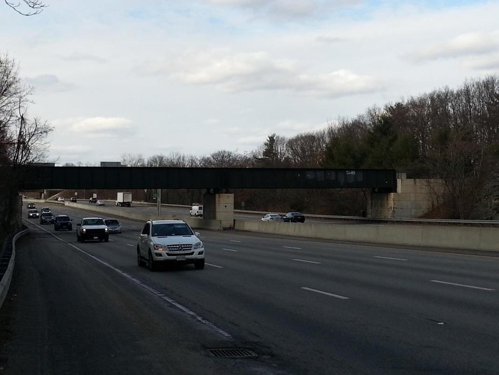
14 2009 Newton Lower Falls Rail Bridge

15 2012 After

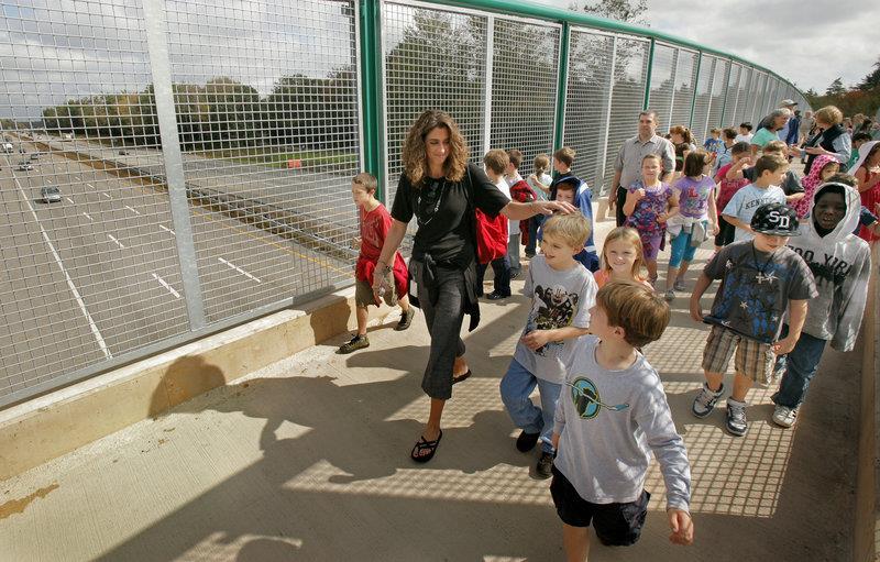
16 May 2012 Newton Lower Falls Rail Trail Opening


17 Bridges over 128 and Mass Turnpike Entrance (Recreation Road)
18 What are we asking for Endorse the concept of a North Section Organizational Challenges Better dialog with town Increase staff & committee involvement Parks & Rec Planning DPW Safe Routes to Schools Become certified bike-friendly town Designate a Bicycle Coordinator Plan for bike connections to, downtown, schools, other towns Involvement of DPW in bike efforts
19 Your action now is important 128 crossing Endorse a holistic rail trail plan, not just unconnected segments far from the population
20 Next Steps Groups meeting with (Wingate, Webster Green, Heights Association) Council on aging Senior Center Speakers Visits to other trails Want town employees and committee members to attend Let this be a shared journey of learning and community building Outreach plan Abutters Senior Center Businesses

21 Thank You Kid on bike, opening ceremony for the new Manahan rail trail bridge, Easthampton, MA

22 Questions? Community Path, Somerville, MA


23 Appendix Ghost Trail, Amesbury, MA

24 Could we do this in Needham? Community Path, Somerville, MA
25 Expected user counts Expected usage is related to available connections with other trails, paths, destinations Short, un-connected segments low usage Longer & well-connected high usage Desired destinations include Schools Transit Housing Shopping & restaurants Recreational (ball fields, parks) Civic (library, senior center, healthcare facilities)

26 Bruce Freeman Time of Day Counts Source:

27 Bruce Freeman Saturday User Counts Source:


28 Economic Impact Houses near the trail sell for a higher proportion of the asking price and in about half the time that it took for houses in the general inventory. The only traffic we got before was local people who live in the neighborhood and now there s a whole slew of people who never knew about this shopping center, mostly people from out east, Hays said. They drag their kids along behind them. They hang out and eat and ride back. A lot of my friends who live out east I see now regularly because before they had no reason to come here. Source:
29 What are the major work items? North Section: Evaluate Green Line / Busway / Rail Trail If Rail Trail is chosen, then study: Surface Paved vs. Stone Dust Bridges Charles River near Red Wing Bay / Fisher Street crossing to Dover Charles River near Wexford Street Needham / Oak Street Newton Route 128 Mass Highway plans to widen highway in 2014 or 2015 Parking Red Wing Bay? Cost Surfaces, bridges, parking Fundraising How much money is needed and how to raise it Lease from MBTA Liability from contamination Liability Insurance Maintenance Leaves, Litter, surface, parking, signs

30 Bridges (we have 3) Moms with stroller and dog, Lamoille Valley Rail Trail, Swanton VT

31 Stone Dust Surface? Moms with kids, Lamoille Valley Rail Trail, Swanton VT

32 Paved Asphalt Surface?
33 I have been hearing the rail trail is making progress, so why is a committee needed? South section is being studied Needham Junction to Dover 1.9 miles North section has been omitted Newton to Needham Heights 1.1 miles Need a public process for engagement with stakeholders No meeting agenda, notice, announcements, minutes, documents, meeting materials, budgets, timelines, decisions South Needham residents invited, North Needham residents excluded from private meetings held in town buildings
34 Why now? Lease is available to be signed with the MBTA Construction company will build it now for free Newton is building a rail trail up to the Needham Town Line at Wexford Street Green Line not feasible MBTA has no money Route 128 bridge needs to be replaced Selectmen policy regarding the north section is?
35 Could the rail line be used now for a rail trail and later converted to add a Bus Roadway or Green Line Extension? Yes This is why the MBTA only leases the right-ofway to the town, so later they can build transportation projects Another option preferred by the selectmen is to offer the rail right-of-way to adjacent future potential developers This would likely be rejected by the neighbors and MassDOT
36 Is the rail line a recommended place to build a bus roadway? Probably not Neighbors would likely object to a roadway adjacent to their house Transit typically is built near density, road networks, merchants, multi-unit housing (called Transit-Oriented-Development, TOD) The existing rail right-of-way is quarter to half mile away from existing density Ideally, use signal prioritization on existing # 59 bus to reduce delays from traffic signals. Signal prioritization is used by emergency vehicles to turn lights green to clear intersections. Needham emergency vehicles are already equipped for this MBTA can inexpensively add signal prioritization to improve bus fleet service, making it more attractive and desirable for middle class riders This is called BRT Bus Rapid Transit, an affordable transit option

37 Newton Needham Green Line Extension New Green Line riders would be cannibalized from commuter rail Fast commuter rail would be traded for slow Green Line Few net-new riders High operating subsidy per rider High capital cost per rider Image from 2003 State Study

38 Millis Commuter Rail Image from 2003 State Study
39 A Better City: Fixing Transit Finance, a Framework for Discussion, April 2011
40 MBTA Debt Load bad and getting worse A Better City: Transportation Finance

41 A Better City: Fixing Transit Finance, a Framework for Discussion, April 2011

42 A Better City: Fixing Transit Finance, a Framework for Discussion, April 2011
43 A Better City: Fixing Transit Finance, a Framework for Discussion, April 2011
44 A Better City: Fixing Transit Finance, a Framework for Discussion, April 2011

45 Would adjacent private developers build the Green Line? Source: 2009 Dukakis Center / Conservation Law Foundation: Blue Ribbon summit on Financing the MBTA
46 2009 Former John Hancock CEO David D Alessandro MBTA Finance Funding Recommendations David F. D'Alessandro MBTA Review, November
47 A Better City: Fixing Transit Finance, a Framework for Discussion, April 2011

48 Plenty of available commuter rail seats

49 Community Path, Somerville, MA
50 Construction Timeline Newton Aldermen Vote October 2012 Lease with MBTA December 2012 Contract with Iron Horse company Q Construction Completed Q Needham?
51 Construction Cost Iron Horse company removes steel rail Sells for scrap or re-use Properly disposes of hazardous wooden ties Builds a basic surface All for no cost Make enough money to break even by selling the steel If more work is desired, such as parking, fencing, fancy surfaces, there may be extra cost But basically we can have a free rail trail in 2013
52 State Funding House 4373 July $250,000 shall be expended for a rail trail in the towns of Needham, Dover and Medfield no less than $50,000 shall be expended for the city of Newton's conversion of the abandoned, Massachusetts Bay Transportation Authority controlled rail line parallel to Needham street in the city of Newton to a linear park, with potential future conversion to a green-line extension House 2376 & Senate 2376 Authorizes funding Governor would need to Appropriate funding Thanks to our state house delegation, particularly Rep Denise Garlick!

53 We could use a bridge like this when route 128 adds more lanes in 2014 / 2015

54 Maine Turnpike Bridge
55

56 Many other towns have rail trails

57 Long range state-wide plan
58 Stone Dust Path, Devils River WI Needham Planning Board February Rail Trail Overview Needham Rail Trail Greenway: Working with the town to assist, advise and coordinate rail trail greenway planning, design, construction and operation
59 Street Webster and Gould
60 Organizational Challenges Who votes? Multi-town meetings are secret Town employees only talk with Tad Only Tad can talk with town employees No info on town website No meeting notice via town website
61 West Roxbury Connection Along Rail Line Under Power Lines Connections to Millennium Park Ideal for downtown bike commuting
62 Senior Center Senior center details Walkway along train line Rail with Trail examples Hersey
63 Charles River Bridge design
64 Summary of solution Surface Crossings Fences Parking
65 Project Management Individual citizens are carrying the project Without them it would stall, there is little town ownership & initiative Health Issues
66 Legal MBTA lease Town Contract Insurance
67 Schedule Tie to Newton s efforts Iron Horse (has anyone met with them?) Prepare for Paving
68 Issues / Concerns Has Iron Horse gone over a highway Would this project slow down add-a-lane project? What protections during bridge work over 128
69 Iron Horse Towns Miles Bridges Street Crossings Budgets Feasibility studies Town involvement Friends group involvements Schedule Contract Mitigation during construction
70 2009 Newton Lower Falls Rail Trail Bridge
71 2009 Newton Lower Falls Rail Trail Bridge
72 2009 Newton Lower Falls Rail Trail Bridge
Longmont to Boulder Regional Trail Jay Road Connection DRAFT FINAL REPORT
 Longmont to Boulder Regional Trail Jay Road Connection DRAFT FINAL REPORT December 2018 Project Summary Boulder County, Colorado, in partnership with the City of Boulder, is evaluating options for multi-use
Trail # NW Tuesday, June DESIGN. Provide an Review the Provide an. Project Goals: System system. wayfinding
 I. Welcome / Introductions Bethany Creek Trail #2 Segment 3 Neighborhood Meeting #1 Bethany Presbyterian Church 15505 NW Springville Road, Portland, OR 97229 Tuesday, June 26, 2018 @ 6:00PM Meeting Minutes
Georgetown-Lewes Rail/Trail Study. Rail/Trail Study: Cool Spring to Cape Henlopen State Park New Road Extension (House Resolution No.
 Georgetown-Lewes Rail/Trail Study Rail/Trail Study: Cool Spring to Cape Henlopen State Park New Road Extension (House Resolution No. 47) August 22, 2011 Presentation Outline Background Benefits Statewide
Non-Motorized Transportation
 Non-Motorized Transportation Non-motorized facilities are important components to the transportation system. They provide an environmentally-friendly, low-cost mode of travel. Some of the facilities can
Macleod Trail Corridor Study. Welcome. Macleod Trail Corridor Study Open House. Presentation of Proposed Design Concepts
 Macleod Trail Corridor Study Welcome Macleod Trail Corridor Study Open House Presentation of Proposed Design Concepts Study Purpose Develop a corridor plan for Macleod Trail that aligns with The City s:
Our Region. Mountains of Northeast Tennessee
 Rails to Trail Our Region Our Region Mountains of Northeast Tennessee Brief History / Whose Idea David Ornduff, City of Elizabethton 1991 Protect the corridor *Steve Darden, Mayor of Johnson City 2005,
Chapter 6: POLICY AND PROCEDURE RECOMMENDATIONS
 Chapter 6 POLICY AND PROCEDURE RECOMMENDATIONS FOR SRRA Below are seven policy elements that should be considered for adoption by the Southwest Regional Recreation Authority of Virginia: 1. Develop strategies
A CASE FOR COMPLETING THE JORDAN RIVER PARKWAY: A
 A CASE FOR COMPLETING THE JORDAN RIVER PARKWAY: A safe crossing at 9000 South and 850 West Proposed 9000 South Underpass Parkway Timeline Parkway, Trail, and Tourism Facts Blueprint Jordan River 1971 1973
University Region Non-Motorized Plan 2015
 Non-Motorized Transportation Non-motorized facilities are important components to the transportation system. They provide an environmentally-friendly, low-cost mode of travel. Some of the facilities can
City Council Workshop July 26, 2010
 Des Moines Trails Connecting a Community City Council Workshop July 26, 2010 1 OVERVIEW Trail Benefits Trails Progress How We Fund Trails What s Next for Trails 2 What is a trail? Paved Trails 10 wide
Miami Orlando Passenger Rail Project Overview
 Miami Orlando Passenger Rail Project Overview 1 The Historical Significance of Florida East Coast Industries Henry Flagler transformed Florida when he built his railroad FEC Railway connected cities along
City of Durango 5.8 FUNDING TRAILS DEVELOPMENT
 5.8 FUNDING TRAILS DEVELOPMENT The City has been successful in establishing dedicated local funding sources as well as applying for grants to develop the City s trail system, having received nearly $2.4
System Group Meeting #1. March 2014
 System Group Meeting #1 March 2014 Meeting #1 Outcomes 1. Understand Your Role 2. List of Revisions to Existing Conditions 3. Information Sources Study Area The Purpose of Mountain Accord is to Preserve
Citrus Heights Creek Corridor Trail Project Trail Advisory Group Field Trip #2 September 11, :00 11:00 am Trellis Hall, Citrus Heights
 September 11, 2013 9:00 11:00 am Trellis Hall, Citrus Heights Project Overview The City of Citrus Heights is studying the feasibility of establishing a multi use trail system within the City s 26 miles
Welcome to the Cross County Trail Public Input Session!
 Welcome to the Cross County Trail Public Input Session! Please sign in on the table below! What are we doing here? Camden County has proposed a bicycle and pedestrian trail spanning across the entire county.
Coast to Coast Connector Summit
 Project Partners Welcome to the Coast to Coast Connector Summit Winter Garden, Florida City Hall October 1, 2014 1 Why are we here? Objectives 1. Inform key stakeholders on the current state of the C2C
Stage 2 ION: Light Rail Transit (LRT) from Kitchener to Cambridge
 from Kitchener to Cambridge") Stage 2 ION: Light Rail Transit (LRT) from Kitchener to Cambridge Public Consultation Centre (PCC) No. 3 Please Sign-in Cambridge City Hall November 21, 2017 2:00 to 8:00pm Preston Memorial Auditorium
Stage 2 ION: Light Rail Transit (LRT) from Kitchener to Cambridge Public Consultation Centre (PCC) No. 3 Please Sign-in Cambridge City Hall November 21, 2017 2:00 to 8:00pm Preston Memorial Auditorium
AGENDA ITEM 5 D WAKULLA ENVIRONMENTAL INSTITUTE (WEI) TRAIL FEASIBILITY STUDY
 TRAIL FEASIBILITY STUDY") March 19, 2018 AGENDA ITEM 5 D WAKULLA ENVIRONMENTAL INSTITUTE (WEI) TRAIL FEASIBILITY STUDY TYPE OF ITEM: Action STATEMENT OF ISSUE The Wakulla Environmental Institute (WEI) Trail is one of several trails
March 19, 2018 AGENDA ITEM 5 D WAKULLA ENVIRONMENTAL INSTITUTE (WEI) TRAIL FEASIBILITY STUDY TYPE OF ITEM: Action STATEMENT OF ISSUE The Wakulla Environmental Institute (WEI) Trail is one of several trails
Dover Park Master Plan. Community Design Event Tuesday, May 22, 5 7 pm
 Dover Park Master Plan Community Design Event Tuesday, May 22, 5 7 pm Agenda I. Introduction / Overview 20 minutes II. Small Group Design Activity 60 minutes III. Small Group Report Out IV. Conclusion
OR MISSION TRAIL ELEMENTARY
 Leawood: overview OVERLAD PARK 24: p.70 I-LA PARK 32: p.72 TOMAHAWK PARK 23: p.69 31: p.71 GEZER PARK OR MISSIO TRAIL ELEMETARY 22: p.68 W 133rd St W 135th St KASAS CITY MO - other segments Beginning/end
ONONDAGA CREEKWALK PHASE II. Public Information Meeting Series 1
 ONONDAGA CREEKWALK PHASE II Public Information Meeting Series 1 Andrew Maxwell Director, Syracuse-Onondaga County Planning Agency Owen Kerney Assistant Director for City Planning Russell Houck, PE City
Blueways: Rivers, lakes, or streams with public access for recreation that includes fishing, nature observation, and opportunities for boating.
 Parks, Open Space and Trails PRINCE WILLIAM COUNTY 2008 COMPREHENSIVE PLAN TRAILS PLAN CONTENTS The components of the trails plan are: Intent Definitions Goals, Policies, and Action Strategies Trails Map
2. Goals and Policies. The following are the adopted Parks and Trails Goals for Stillwater Township:
 D. PARKS AND TRAILS 1. Introduction Stillwater Township s population is relatively low, with most residents living on rural residences on large lots. The need for active park space has been minimal in
IL 390 Station. Wood Dale Open House Summary 5/18/17
 Wood Dale Open House Summary 5/18/17 The first public open house for the Wood Dale Comprehensive Plan took place on May 18 th, 2017. The program was conducted as a fun community event and there were 216
DRAFT - APRIL 13, 2007 ROUTING STUDY FOR TRAIL CONNECTIONS BETWEEN CALAIS AND AYERS JUNCTION
 DRAFT - APRIL 13, 2007 ROUTING STUDY FOR TRAIL CONNECTIONS BETWEEN CALAIS AND AYERS JUNCTION Abstract The vision for the East Coast Greenway is an off-road urban trail system running from Calais, Maine
Sudbury to Hudson Transmission Reliability Project
 An independent assessment of routing options Sudbury to Hudson Transmission Reliability Project and use of a rail-banked corridor for this purpose Prepared by: NorthEast Logistics Systems, LLC August 29,
Introduction. Project Overview
 Washington Blvd./Andora Widening Project Community Open House & Public Scoping Meeting Summary Wednesday, September 21, 2016 6:00 7:30 p.m. Vencil Brown Elementary School, Roseville Introduction On Wednesday,
Multimodal Planning Studies
 Multimodal Planning Studies Commuter Park and Ride Study Steering Committee Meeting June 6, 2013 Agenda 1. Update on Project Schedule 2. Update on Online Interactive Mapping 3. Key Themes from the Open
Miami Orlando Passenger Rail Project Overview
 Miami Orlando Passenger Rail Project Overview 1 The Historical Significance of Florida East Coast Industries Henry Flagler transformed Florida when he built his railroad FEC Railway connected cities along
China Creek North Park Upgrades and Glen Pump Station. Park Board Committee Meeting Monday, July 10, 2017
 China Creek North Park Upgrades and Glen Pump Station Park Board Committee Meeting Monday, July 10, 2017 Purpose The purpose of this presentation is to: Share the results of the public engagement processes;
Trail Feasibility Study
 VOLUSIA COUNTY MPO CITY OF NEW SMYRNA BEACH FINAL REPORT JUNE 30, 2009 Trail Feasibility Study What s inside? 1 Introduction 2 Project Purpose & Scope 3 Physical Inventory & Assessment of Right-of- Way
STEP ALTERNATIVES RANKING TABLE
 ALTERNATIVES RANKING TABLE Priority Ranking 0 = Lowest Priority 1 2 3 4 5 = Highest Priority Abbreviations TD = Transportation Disadvantaged PWD = People with Disabilities I. Existing Enhancements Increase
Those with Interest in the City of Cambridge Trail System
 Community Services Department City Hall 50 Dickson Street, P.O. Box 669 Cambridge ON N1R 5W8 Tel: 519-740-4681 July 20, 2010 To: Re: Those with Interest in the City of Cambridge Trail System City of Cambridge
TransAction Overview. Introduction. Vision. NVTA Jurisdictions
 Introduction Vision NVTA Jurisdictions In the 21 st century, Northern Virginia will develop and sustain a multimodal transportation system that enhances quality of life and supports economic growth. Investments
ORANGE COUNTY TRANSPORTATION AUTHORITY. Go Local Fixed-Guideway Program History and Project Update. PowerPoint 3
 ORANGE COUNTY TRANSPORTATION AUTHORITY Go Local Fixed-Guideway Program History and Project Update PowerPoint 3 Santa Ana-Garden Grove Fixed Guideway Project OCTA Board of Directors September 26, 2011 Project
POLICY ON VISITOR USE AND ACTIVITIES IN PARRAMATTA PARK
 POLICY ON VISITOR USE AND ACTIVITIES IN PARRAMATTA PARK Contact Officer: Visitor Services Officer Policy Approval Date: 10 January 2017 Next Policy Review Date: 10 January 2019 Published Date: 13 January
Park to Playa Trail. June 17, 2014
 Park to Playa Trail June 17, 2014 Representatives: Park to Playa Trail Karly Katona, Deputy for Sustainability & Economic Development, Office of Supervisor Mark Ridley-Thomas David McNeill, Executive Officer,
FEASIBILITY CRITERIA
 This chapter describes the methodology and criteria used to evaluate the feasibility of developing trails throughout the study areas. Land availability, habitat sensitivity, roadway crossings and on-street
A VISION FOR EL MIRAGE
 el mirage A VISION FOR EL MIRAGE OASIS, ARIZONA A thriving desert jewel destination with a strong arts district, high-wage employment parks system joined together by cohesive, multi-use accessible trails
The Future of the Road to Revolutions. A Battle Road Scenic Byway Public Forum November 9, 2010
 The Future of the Road to Revolutions A Battle Road Scenic Byway Public Forum November 9, 2010 Who is the Battle Road Scenic Byway? Four Towns: Arlington, Lexington, Lincoln, Concord Minute Man National
2016 Regional Transportation Alternatives Program (TAP) Grant Application
 Grant Application") 2016 Regional Transportation Alternatives Program (TAP) Grant Application PROJECT TITLE: Yelm-Tenino Trail Extension Feasibility Study TRPC use only GENERAL PROJECT INFORMATION Agency or Organization City
2016 Regional Transportation Alternatives Program (TAP) Grant Application PROJECT TITLE: Yelm-Tenino Trail Extension Feasibility Study TRPC use only GENERAL PROJECT INFORMATION Agency or Organization City
Committee. Presentation Outline
 CW-33-15 11/9/2015 Community and Corporate Services Committee November 10, 2015 1 Presentation Outline Background Vision and Objectives Study Process and Timeline Public and Stakeholder Engagement Organization
McLean Citizens Association Transportation Committee Project Briefing
 McLean Citizens Association Transportation Committee Project Briefing November 10, 2015 Project Map 2 Project Context Only Interstate in the Country limited to HOV only traffic during rush hours Stoplight
Whittier Bridge Project
 Amesbury / Newburyport / Salisbury Whittier Bridge / I-95 Improvement Project Original Whittier Bridge Proposed Whittier Bridges 10/21/2016 Whittier Bridge Project 1 Project Description The project limits
At the time, the portion of the line through Eagle County remains wholly under the ownership of Union Pacific Railroad (UP).
.") Chapter 5 The Railroad Corridor as a Trail Corridor The intent of this chapter is to identify how the rail corridor, if available for lease or purchase in all or part, could be incorporated into the core
Chapter 5 The Railroad Corridor as a Trail Corridor The intent of this chapter is to identify how the rail corridor, if available for lease or purchase in all or part, could be incorporated into the core
Trail Etiquette. Hours of Operation. Trail Accessibility
 Trail Guide The Elmhurst Park District, with 28 parks and over 460 acres of land, offers nearly six miles of paved or asphalt park trails and maintains an additional 3.6 miles of trails within Elmhurst.
Public Information Meetings. October 5, 6, 7, and 15, 2015
 Public Information Meetings October 5, 6, 7, and 15, 2015 Project Map 2 Project Context Only Interstate in the Country limited to HOV only traffic during rush hours Stoplight at the end of I-66 eastbound
Welcome and thank you for being here! Kick-Off Public Workshop November 19, 2014
 Welcome and thank you for being here! Kick-Off Public Workshop November 19, 2014 OPEN SPACE MATTERS: Boise s First Reserve Master Plan Julia Grant Foothills and Open Space Manager City of Boise Ellen Campfield
MORGAN CREEK GREENWAY Final Report APPENDICES
 APPENDICES MORGAN CREEK GREENWAY Appendix A Photos of Existing Conditions in Trail Corridor Photos of existing conditions Main trail corridor - February 2009 Photos of existing conditions south bank Morgan
Creating Sustainable Communities Through Public Transportation
 Creating Sustainable Communities Through Public Transportation 21 st Transportation Committee January 16, 2008 Keith T. Parker Chief Executive Officer Charlotte Area Transit System (CATS) Charlotte Mecklenburg
Why we re here: For educational purposes only
 Transportation 2050 Why we re here: For educational purposes only Transportation 2050 Bus Elements PUBLIC TRANSIT DEPARTMENT City of Phoenix Citizens Committee on the Future of Phoenix Transportation (CCFPT)
Part 005 Implementation Strategy _
 Part 0 Implementation Strategy www. landlab.co.nz Queenstown Town Centre Masterplan Version 7 14 June 28 Section 0 Page 4 5.1 Implementation Plan The projects and initiatives contained within the Queenstown
Trail Use in the N.C. Museum of Art Park:
 Trail Use in the N.C. Museum of Art Park: New Connections, New Visitors Jacqueline MacDonald Gibson, PhD Daniel Rodriguez, PhD Taylor Dennerlein, MSEE, MCRP, EIT Jill Mead, MPH Evan Comen University of
Gardner: overview. Santa Fe, Oregon, and California National Historic Trails UNINCORPORATED JOHNSON COUNTY OLATHE UNINCORPORATED JOHNSON COUNTY
 Santa Fe, Oregon, and California ational Historic Trails : overview 99: p.134 100: p.135 GARDER JUCTIO 102: p.137 56: p.126 EDGERTO Burlington orthern Intermodal and Logistics 98: p.133 101: p.136 S Waverly
7:00 p.m. General meeting called to order. Paul Conte, Chair 7:05 p.m. Introductions Reminder: All JWN members should fill out and return a sign-in
 Agenda 7:00 p.m. General meeting called to order. Paul Conte, Chair 7:05 p.m. Introductions Reminder: All JWN members should fill out and return a sign-in card to receive a ballot. All guests are requested
SR 934 Project Development And Environment (PD&E) Study
 Study") SR 934 Project Development And Environment (PD&E) Study Project Advisory Group Meeting March 1, 2018 State Road 934/NE/NW 79th Street from west of I-95 (NW 13th CT) to N. Bayshore Drive PD&E STUDY SR 934/NE/NW
SR 934 Project Development And Environment (PD&E) Study Project Advisory Group Meeting March 1, 2018 State Road 934/NE/NW 79th Street from west of I-95 (NW 13th CT) to N. Bayshore Drive PD&E STUDY SR 934/NE/NW
EXHIBIT 1. BOARD AUTHORIZATION FOR PUBLIC HEARING AND SUBSEQUENT ISSUANCE OF A JOINT DEVELOPMENT SOLICITATION
 EXHIBIT 1. BOARD AUTHORIZATION FOR PUBLIC HEARING AND SUBSEQUENT ISSUANCE OF A JOINT DEVELOPMENT SOLICITATION Washington Metropolitan Area Transit Authority Board Action/Information Summary @Action O Information
Sevierville, TN. Technical Appendices
 Sevierville, TN Technical Appendices 2017 2955 Valmont Road Suite 300 777 North Capitol Street NE Suite 500 Boulder, Colorado 80301 Washington, DC 20002 n-r-c.com 303-444-7863 icma.org 800-745-8780 Contents
Northeast Quadrant Distinctive Features
 NORTHEAST QUADRANT Northeast Quadrant Distinctive Features LAND USE The Northeast Quadrant includes all the area within the planning area that is east of Interstate 5 and to the north of State Route 44.
FINCH HYDRO CORRIDOR TRAIL PROJECT
 FINCH HYDRO CORRIDOR TRAIL PROJECT Pharmacy Avenue to Birchmount Road January 29 th, 2018 L Amoreaux Community Centre (2000 McNicoll Avenue) 1 Purpose of Drop In Event The purpose of today s drop-in event
PLANNING COMMISSION AGENDA REPORT May 10, Members of the Planning Commission. Joyce Parker-Bozylinski, Contract Planner
 PLANNING COMMISSION AGENDA REPORT May 10, 2007 TO: FROM: PROPOSAL: APPLICANT: RECOMMENDATION: Members of the Planning Commission Joyce Parker-Bozylinski, Contract Planner Approval of the Calabasas Trails
Lafourche Parish Government REQUEST FOR QUALIFICATIONS. Landscape Architectural Services
 Lafourche Parish Government REQUEST FOR QUALIFICATIONS Landscape Architectural Services Bayou Lafourche Parish Multi-Use Path Feasibility Study Phase 1 And Bayou Lafourche Parish Multi-Use Path Feasibility
Tallahassee-St. Marks Historic Railroad Trail
 Revitalizing a Historic Trail Designated as a National Recreation Trail, the 16-mile Tallahassee-St. Marks Historic Railroad Trail has been enjoyed by countless bicyclists, runners, and outdoor enthusiasts
MARTA & City of Atlanta Sales Tax Referendums. Public Hearings May 25 & 26, 2016 June 1 & 2, 2016
 MARTA & City of Atlanta Sales Tax Referendums 1 MARTA & City of Atlanta Sales Tax Referendums Public Hearings May 25 & 26, 2016 June 1 & 2, 2016 MARTA & City of Atlanta Sales Tax Referendums 2 Guiding
PDAC Priority Project East Dayton Rails-to-Trails (Flight Line) Project Description
 Project Description") PDAC Priority Project East Dayton Rails-to-Trails (Flight Line) Project Description The Flight Line project represents an amazing opportunity to become a truly transformative urban recreational trail that
PDAC Priority Project East Dayton Rails-to-Trails (Flight Line) Project Description The Flight Line project represents an amazing opportunity to become a truly transformative urban recreational trail that
Public Informational Meeting
 Public Informational Meeting April 17, 2007 Bow-Concord I-93 I Transportation Planning Study Bow-Concord Interstate 93 Transportation Planning Study Context Sensitive Solutions Planning Steps Screen Alternatives
TRAFALGAR PARK. 78: p.140 W 99th St FLAT ROCK CREEK PARK. W 103rd St OVERLAND PARK. Quivira Rd. College Blvd. Shared use path. Mountain bike trail
 Lenexa: overview TRAFALGAR PARK 78: p.140 As the Westport Route crosses over Lenexa's boundaries with Olathe and Overland Park several times, approximately 2.75 or 3 miles of the historic route of the
Executive Summary. See Figure ES-5 on page 9. Figure ES-6: Typical At-Grade Alignment. Figure ES-7: Typical Underground Alignment
 Figure ES-5 shows all of the possible LRT routes and stations identified for study in the Draft EIS/EIR. The features and impacts of each of the build alternatives are described in the following section.
CITY OF BROOKFIELD Capital Improvement Fund Budget
 CITY OF BROOKFIELD Capital Improvement Fund Budget The City adopts an annual capital improvement budget, based on a five-year capital improvement program (CIP). The annual budget and CIP are prepared by
West Orange Trail. Clean, Green, Fun!
 West Orange Trail Clean, Green, Fun! The West Orange Trail - when completed - will be a 36-mile, multipurpose recreational greenway containing a 14-foot wide paved surface to be enjoyed by walkers, joggers,
MPRB: Southwest LRT Community Advisory Committee Issues and Outcomes by Location Current to: 12 November 2010
 MPRB: Southwest LRT Community Advisory Committee Issues and Outcomes by Location Current to: 12 November 2010 This is a compilation of issues and outcomes identified by the CAC. It is a work in progress,
Update of MDX Open Road Tolling
 Update of MDX Open Road Tolling Citizens Transportation Advisory Committee September 11, 2013 About MDX MDX is an agency of the state created by the State Legislature and the County Commission to assure
Making a River Segment Family and People Friendly: A Case Study of the Pemi River in the Plymouth Region
 Making a River Segment Family and People Friendly: A Case Study of the Pemi River in the Plymouth Region Kenneth Evans, Plymouth Rotary Club Patrick Hummel, DIvision of Parks & Recreation; Larry Spencer,
Assessing Your Trails, Keeping Them Safe and Enjoyable
 Jon Wood, PLA, ASLA Associate Vice President Stewart Bert Lynn, PLA, ASLA, LEED AP Project Manager Mecklenburg County Asset and Facility Management Assessing Your Trails, Keeping Them Safe and Enjoyable
A BOAT RAMP TO NOWHERE
 A BOAT RAMP TO NOWHERE A PROPOSAL FOR ACCESS TO HARVIE PASSAGE A Presentation to the City of Calgary December 2017 Presented by: Peter Crowe-Swords Bow River Trout Foundation Background: The Bow River
Metro ExpressLanes April 5, 2011 Community Meeting re: Adams Blvd Improvements
 Metro ExpressLanes April 5, 2011 Community Meeting re: Adams Blvd Improvements Jan Perry Councilwoman, District 9 Welcome Remarks Arthur T. Leahy Chief Executive Officer, Metro Metro ExpressLanes Overview
CITY COUNCIL AGENDA MEMORANDUM
 To: Mayor and City Council From: Charles Ozaki, City and County Manager Prepared By: Kevin Standbridge, Deputy City and County Manager Katie Allen, City and County Engineer David Shinneman, Community Development
Post Oak Blvd & San Felipe St
 MEMORIAL PARK RIVER OAKS UPTOWN PARK FREEWAY WEST LOOP FOUR OAKS PLACE ASTORIA CONDOS BELFIORE CONDOS FOUR LEAF TOWERS BHP BILLITON HQ FRESH MARKET WESTBRIAR LANE 1.6 ACRE DEVELOPMENT SITE STREET FELIPE
Clackamas County Development Agency
 Clackamas County Development Agency Development Services Building, 150 Beavercreek Rd., Oregon City, OR 97045 www.clackamas.us/transportation/renewal 503-742-4323 The Clackamas County Board of Commissioners
TRANSPORTATION ELEMENT
 Transportation TRANSPORTATION ELEMENT Data, Inventory, and Analysis Prepared by Contents 1.0 INTRODUCTION... 1 2.0 EXISTING CONDITIONS... 1 2.1 Roadways... 1 2.1.1 Jurisdiction... 1 2.1.2 Functional Classification...
CHAPTER 5. Chapter 5 Recreation Element
 CHAPTER 5 Recreation Element Chapter 5 Recreation Element The Recreation Element of the Meyers Area Plan is a supplement to the Recreation Element of the TRPA Regional Plan and the El Dorado County General
Attendance Presentation
 TO The Community of Saanich FROM District of Saanich DATE January 30, 2017 RE Meeting Notes Haro Woods Jan 28th Community Engagement Goward House, 2495 Arbutus Road, Victoria BC Attendance In total, 18
MEETING SUMMARY. RE: Transportation, Access, and Connectivity Working Group #1
 MEETING SUMMARY DATE: June 14, 2016 TIME: 9:30AM - 11:30AM LOCATION: 77 West Jackson ATTENDEES: Madeline Shepherd, MPC Sonali Tandon, CTA Jason Navota, CMAP Allison Buchwach, Metra David Kralik, Metra
Arlington County Board Meeting Project Briefing. October 20, 2015
 Arlington County Board Meeting Project Briefing October 20, 2015 Project Map 2 Project Context Only Interstate in the Country limited to HOV only traffic during rush hours Stoplight at the end of I-66
Establishing a National Urban Park in the Rouge Valley
 STAFF REPORT ACTION REQUIRED Establishing a National Urban Park in the Rouge Valley Date: March 29, 2012 To: From: Wards: Reference Number: Executive Committee Deputy City Manager, Cluster B All p:\2012\cluster
SANTA MONICA AIRPORT VISIONING PROCESS: PHASE III FINDINGS AND NEXT STEP RECOMMENDATIONS APRIL 30, 2013
 SANTA MONICA AIRPORT VISIONING PROCESS: PHASE III FINDINGS AND NEXT STEP RECOMMENDATIONS APRIL 30, 2013 Visioning Process: Overview SMO in 1917 (Cloverfield) Grass Landing Strip WWI Pilot Training Visioning
South Bay Metro Green Line Extension
 South Bay Metro Green Line Extension Spring 2011 Community Meetings 1 2 Agenda Introduction Where We ve Been Project Status What s Next Discussion 3 Where We ve Been Scoping Meetings April/May 2010 4 Meetings
CREATING CONNECTIONS IN THE CITY OF NIAGARA FALLS PUBLIC MEETING DECEMBER 6, 2017
 CREATING CONNECTIONS IN THE CITY OF NIAGARA FALLS PUBLIC MEETING DECEMBER 6, 2017 CONGESTION COSTS OUR ECONOMY The average commute in Ontario is already over 45 minutes, and that figure jumps to more than
Strengthening the Ontario Trails Strategy. Report on Consultations and the Environmental Bill of Rights Registry
 Strengthening the Ontario Trails Strategy Report on Consultations and the Environmental Bill of Rights Registry Purpose To report on the feedback and information received through the regional consultations,
Committee Report. Community Development Committee For the Metropolitan Council meeting of April 13, Business Item No.
 Committee Report Business Item No. 2016-48 Community Development Committee For the Metropolitan Council meeting of April 13, 2016 Subject: Harriet Island-South St. Paul Regional Trail Master Plan, Saint
3. COLTA / HUGA CONNECTIONS - PRELIMINARY
 9 3. COLTA / HUGA CONNECTIONS - PRELIMINARY 3.1 COLTA The Chain of Lakes Trail Association (COLTA) trail, formerly identified as the Chester Spur Line, was completed and opened for use in June 2011. The
Dungeness Recreation Area County Park Master Plan
 Dungeness Recreation Area County Park Public Outreach Meeting October 10, 2007 Project Overview USFWS Site Dungeness Recreation Area County Park Meeting Objectives: Re-Introduce project; provide status
Update on the I-680 Transit Corridor Improvement Project HOV on/off Ramps Environmental Impact Report Community Engagement Plan
 Update on the I-680 Transit Corridor Improvement Project HOV on/off Ramps Environmental Impact Report Community Engagement Plan Presentation Overview Introductions Susan Miller, Director of Projects, Contra
DALLAS PARK AND RECREATION BOARD AGENDA DALLAS CITY HALL 1500 MARILLA STREET, ROOM 6FN DALLAS, TEXAS THURSDAY, MARCH 1, 2012 (10:00 A.M.
 DALLAS PARK AND RECREATION BOARD AGENDA (10:00 A.M.) SUBCOMMITTEE MEETINGS: 9:00 am: Administration and Finance Committee, Dallas City Hall, Room 6FS 9:00 am: Planning and Design Committee, Dallas City
Sacramento Placerville Transportation Corridor Alternatives Analysis
 Sacramento Placerville Transportation Corridor Alternatives Analysis EL DORADO COUNTY TRANSPORTATION COMMISSION 1 Sacramento Placerville Transportation Corridor 2 Goal of the Project To give public officials
Charlotte Regional Express Lane Facilities: I-485 and US 74. North Carolina Turnpike Authority March 21, 2018
 Charlotte Regional Express Lane Facilities: I-485 and US 74 North Carolina Turnpike Authority March 21, 2018 NC Turnpike Authority Overview Created in 2002 by the General Assembly Authorized to design,
PROPOSED PARK ALTERNATIVES
 8 Chimne y Rock State Park M a ster Pl an 2011 PROPOSED PARK ALTERNATIVES Introduction Three different park development concepts were prepared and presented to the citizens of North Carolina through a
Welcome. Green Line in Your Community
 Welcome Green Line in Your Community Today s session will provide you with information on options The City is exploring for connecting the Green Line in the Beltline to the future Inglewood/Ramsay station.
Project Deliverable 4.1.3d Individual City Report - City of La Verne
 Pomona Valley ITS Project Project Deliverable 4.1.3d Individual City Report - City of La Verne Prepared by: April 19, 2002 099017000.1 Copyright 2002, Kimley-Horn and Associates, Inc TABLE OF CONTENTS
New System. New Routes. New Way. May 20, 2014
 Route Optimization I N I T I A T I V E New System. New Routes. New Way. May 20, 2014 1 Welcome Blueprint for Transportation Excellence (BTE) 20 year strategic plan Blueprint 2020 JTA s five-year plan for