Redtail Ranch Preliminary Plan and Filing No. 1 Final Plat, Review #2 (SP , SF )
|
|
|
- Miranda Eaton
- 5 years ago
- Views:
Transcription

 Hello Kari, The Planning Division of the Community Services Department has reviewed Redtail Ranch Preliminary Plan and Final Plat, Review #, and has no")
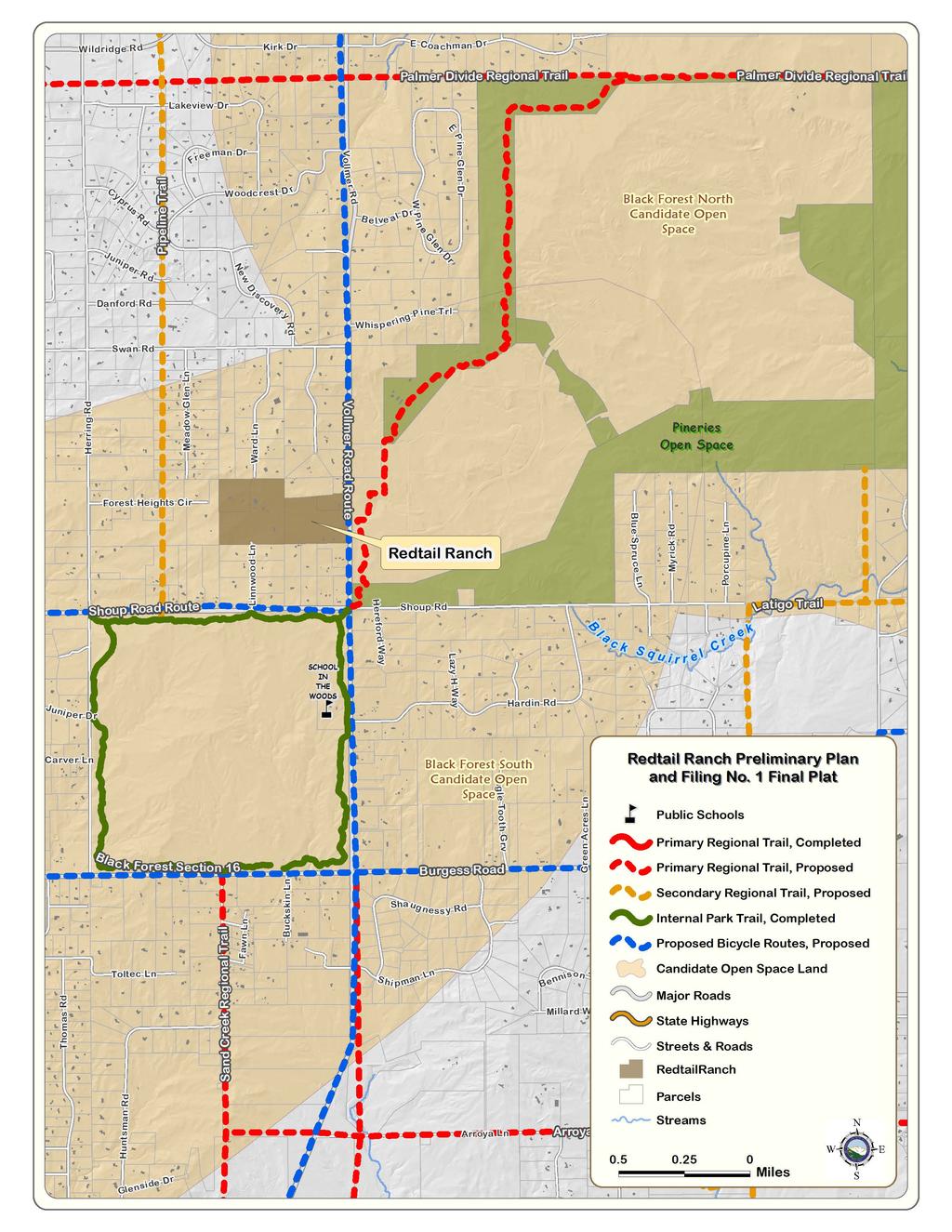
1 COMMISSINERS: DARRYL GLENN (PRESIDENT) MARK WALLER (PRESIDENT PRO TEMPORE) PEGGY LITTLETON LONGINOS GONZALEZ, JR. STAN VANDERWERF COMMUNITY SERVICES DEPARTMENT PARK OPERATIONS ~ PLANNING ~ CSU EXTENSION ~ COMMUNITY OUTREACH ENVIRONMENTAL SERVICES ~VETERANS SERVICES ~ RECREATION/CULTURAL SERVICES December 1, 018 Kari Parsons Project Manager El Paso County Development Services Department 880 International Circle Colorado Springs, CO Subject: Redtail Ranch Preliminary Plan and Filing No. 1 Final Plat, Review # (SP , SF-18-01) Hello Kari, The Planning Division of the Community Services Department has reviewed Redtail Ranch Preliminary Plan and Final Plat, Review #, and has no additional comments of behalf of El Paso County Parks. Staff acknowledges the dedication of the 10-foot wide trail easement along the northern boundary of Lot 1 for the establishment of a local trail connection by the Black Forest Trails Association. The following comments and recommendations were presented to and endorsed by the Park Advisory Board on September 1, 018: Redtail Ranch is a 1 residential lot subdivision totaling 67.9 acres, with a minimum lot size of 5 acres, located northwest of the intersection of Vollmer Road and Shoup Road. The property is currently zoned and is located within the Black Forest Preservation Plan area. The 013 El Paso County Parks Master Plan shows no parks, trails, or open space impacted by the proposed subdivision. The proposed Shoup Road and Vollmer Road Bicycle Routes are located approximately immediately adjacent and 0.5 mile south of the property, respectively while the proposed Pipeline Secondary Regional Trail is located approximately 0.5 mile to the west. The proposed Palmer Divide Primary Regional Trail is located approximately 0.10 mile to the east, within the Pineries Open Space, while the existing Black Forest Section 16 Trail is located approximately 0.5 mile south of the property. The Open Space Master Plan of the Parks Master Plan shows the Black Forest South Candidate Open Space encompassing the project site. Natural resource values include montane ponderosa pine forests intermixed with permanent and intermittent wetlands and woodland prairie communities, serving as habitats for native, relict, and various rare plant species. The project would not be in conflict with the plan, as long as its development does not adversely affect the surrounding existing environment. 00 S. CASCADE AVENUE, SUITE 100 OFFICE: (719) COLORADO SPRINGS, CO FAX: (719)
2 The Black Forest Trails Association is seeking numerous local trail connections both within and in the vicinity of Redtail Ranch. These trails would ultimately connect Black Forest residents with Black Forest Section 16 to the south, and Pineries Open Space to the east. Staff strongly recommends that the developer work closely with the Black Forest Trails Association to locate trail alignments and establish trail connections within the project area. As no park land or trail easements dedications are necessary for this filing, El Paso County Parks staff recommends fees in lieu of land for regional park purposes in the amount of $5,160 as shown on the attached Subdivision Review Form. Recommended Motion (Preliminary Plan): Recommend to the Planning Commission and Board of County Commissioners that approval of the Redtail Ranch Preliminary Plan include the following conditions: (1) work with the Black Forest Trails Association to locate trail alignments and establish local trail connections in the project area, and () fees in lieu of land dedication for regional park purposes in the amount of $5,160 will be required at time of the recording of the forthcoming final plat. Recommended Motion (Filing No. 1 Final Plat): Recommend to the Planning Commission and Board of County Commissioners that approval of the Redtail Ranch Final Plat include the following conditions: (1) work with the Black Forest Trails Association to locate trail alignments and establish local trail connections in the project area, and () require fees in lieu of land dedication for regional park purposes in the amount of $5,160. Please let me know if you have any questions or concerns. Sincerely, Ross A. Williams Park Planner Planning Division Community Services Department rosswilliams@elpasoco.com
3
4 September 1, 018 Redtail Ranch Preliminary Plan SP Preliminary Plan 0 Michael Ludwig 455 Arrowhead Drive Colorado Springs, CO N.E.S., Inc. 619 North Cascade Avenue, Suite 00 Colorado Springs, CO (.5 units or greater / 1 acre) Acres x 1 Dwelling Units = 0.3 acres Acres x 0 Dwelling Units = 0.00 acres Acres x 0 Dwelling Units = 0.00 acres 0.00 acres $ / Unit x 1 Dwelling Units= $5, $ / Unit x 0 Dwelling Units = $0.00 $ / Unit x 0 Dwelling Units = $0.00 $0.00 Recommend to the Planning Commission and Board of County Commissioners that approval of the Redtail Ranch Final Plat include the following conditions: (1) work with the Black Forest Trails Association to locate trail alignments and establish local trail connections in the project area, and () fees in lieu of land dedication for regional park purposes in the amount of $5,160 will be required at time of the recording of the forthcoming final plat. Endorsed 09/1/018
5 September 1, 018 Redtail Ranch Filing No. 1 Final Plat SF Final Plat 0 Michael Ludwig 455 Arrowhead Drive Colorado Springs, CO N.E.S., Inc. 619 North Cascade Avenue, Suite 00 Colorado Springs, CO (.5 units or greater / 1 acre) Acres x 1 Dwelling Units = 0.3 acres Acres x 0 Dwelling Units = 0.00 acres Acres x 0 Dwelling Units = 0.00 acres 0.00 acres $ / Unit x 1 Dwelling Units= $5, $ / Unit x 0 Dwelling Units = $0.00 $ / Unit x 0 Dwelling Units = $0.00 $0.00 Recommend to the Planning Commission and Board of County Commissioners that approval of the Redtail Ranch Final Plat include the following conditions: (1) work with the Black Forest Trails Association to locate trail alignments and establish local trail connections in the project area, and () require fees in lieu of land dedication for regional park purposes in the amount of $5,160. Endorsed 09/1/018
workshop that generated many ideas that found their way into the plan.
 www.blackforesttrails.org To create a safe, legitimate, non-motorized, multi-use recreational trail system that connects Black Forest neighborhoods to each other and the El Paso County Regional Trail System
MUNICIPALITY OF ANCHORAGE
 DATE: June 3, 2009 MUNICIPALITY OF ANCHORAGE PARKS & RECREATION DEPARTMENT MEMORANDUM PRC #09-35 TO: FROM: SUBJECT: Parks and Recreation Commission Tom Korosei, Park Planner Proposed Land Exchange for
Proposed Official Plan Amendment 41 to the Region of York Official Plan
 COMMITTEE OF THE WHOLE NOVEMBER 18, 2002 REGION OF YORK OFFICIAL PLAN AMENDMENT 41 THE OAK RIDGES MORAINE CONSERVATION PLAN Recommendation The Commissioner of Planning recommends: 1. That the City of Vaughan
Community Development Department Council Chambers, 7:30 PM, December 20, 2012
 STAFF REPORT 2012-56P: Alley Vacation Community Development Department Council Chambers, 7:30 PM, December 20, 2012 To: From: Re: Paul Luke, Chairman, Skokie Plan Commission Mike Voitik, Planning Technician
PARCEL ID ACREAGE MAIL TO MAILING ADDRESS
 PARCEL ID ACREAGE MAIL TO MAILING ADDRESS City, State, Zip Parcel Location Description 5720005001 0 Carolina Castro 7935 MOHAWK RD COLORADO SPRINGS CO 80908-5007 7485 Rancho Colorado Blvd 5717005005 7.4
Spadina Avenue Built Form Study Preliminary Report
 STAFF REPORT ACTION REQUIRED Spadina Avenue Built Form Study Preliminary Report Date: July 9, 2014 To: From: Wards: Reference Number: Toronto and East York Community Council Director, Community Planning,
Medina Park Commission Meeting Minutes August 26, 2014 Medina City Hall Page 1 of 6
 1 of 6 The Park Commission of Medina, Minnesota met in special session on at 6:00 p.m. at. Park Commission Chair Ann Thies presided. 1) Call to Order Commissioners Present: Commissioners Absent: Also Present:
Parker & Lincoln Development, LLC
 Parker & Lincoln Development, LLC 4643 S. Ulster Street, Suite 240 Denver, Colorado 80237 (303) 799-4030 VIA FEDEX OVERNIGHT DELIVERY December 19, 2017 Town of Parker Attn: Ryan McGee 20120 E. Mainstreet
Business Item No
 Metropolitan Parks and Open Space Commission Meeting date: February 6, 2018 For the Community Development Committee meeting of February 20, 2018 For the Metropolitan Council meeting of February 28, 2018
2. Goals and Policies. The following are the adopted Parks and Trails Goals for Stillwater Township:
 D. PARKS AND TRAILS 1. Introduction Stillwater Township s population is relatively low, with most residents living on rural residences on large lots. The need for active park space has been minimal in
Thornton Water Project. Larimer County Route Study and Project Update September 12, 2017
 Thornton Water Project Larimer County Route Study and Project Update September 12, 2017 Purpose of Meeting Provide information on the Thornton Water Project Present the results of the pipeline routing
PLATTE COUNTY PLANNING AND ZONING JANUARY 15, 2014
 PLATTE COUNTY PLANNING AND ZONING JANUARY 15, 2014 Acting Chairman Bob Brockman called the Platte County Planning and Zoning Commission meeting to order at 7:00 P.M. The only Commission member present
METROPOLITAN COUNCIL 390 North Robert Street, St. Paul, MN Phone (651) TDD (651)
 TDD (651)") DATE: March 27, 2012 METROPOLITAN COUNCIL 390 North Robert Street, St. Paul, MN 55101 Phone (651) 602-1000 TDD (651) 291-0904 TO: Metropolitan Parks and Open Space Commission FROM: Arne Stefferud, Planning
DATE: March 27, 2012 METROPOLITAN COUNCIL 390 North Robert Street, St. Paul, MN 55101 Phone (651) 602-1000 TDD (651) 291-0904 TO: Metropolitan Parks and Open Space Commission FROM: Arne Stefferud, Planning
MONTGOMERY COUNTY PLANNING DEPARTMENT THE MARYLAND-NATIONAL CAPITAL PARK AND PLANNING COMMISSION
 MONTGOMERY COUNTY PLANNING DEPARTMENT THE MARYLAND-NATIONAL CAPITAL PARK AND PLANNING COMMISSION Three Sisters Road: Abandonment No. AB740 MCPB Item No. 11 Date: 5-1-14 Katherine Holt, Senior Planner,
Toronto and East York Community Council. Director, Toronto Building, Toronto and East York District
 STAFF REPORT ACTION REQUIRED Sign Variance - 77 King St W Date: October 16, 2008 To: From: Wards: Reference Number: Toronto and East York Community Council Director, Toronto Building, Toronto and East
August 30, Adam Sayre City of Verona Planning & Development 111 Lincoln Street Verona, WI 53593
 August 30, 2018 Adam Sayre City of Verona Planning & Development 111 Lincoln Street Verona, WI 53593 RE: Second Addition to Cathedral Point City of Verona Future Public Works Facility Annexation Description
REQUEST FOR PLANNING COMMISSION ACTION
 REQUEST FOR PLANNING COMMISSION ACTION DATE: 06/03/09 ITEM NO: 5e Department Approval: Agenda Section: PUBLIC HEARINGS Item Description: Request by City of Roseville for the vacation of public right-of-way
Community Development Department Council Chambers, 7:30 PM, October 4, Related Case P: Site Plan Approval
 STAFF REPORT 2018-34P: Street Vacation Community Development Department Council Chambers, 7:30 PM, October 4, 2018 To: From: Re: Paul Luke, Chairman, Skokie Plan Commission Mike Voitik, Associate Planner
I-579 Urban Open Space CAP Project. Final Land Development Plan (FLDP) Pittsburgh Department of City Planning
 Pittsburgh Department of City Planning") Final Land Development Plan (FLDP) I-579 Urban Open Space CAP Project Sports & Exhibition Authority (SEA) of the City of Pittsburgh and Allegheny County Project bounded by Chatham St. / Centre Ave. / Washington
Final Land Development Plan (FLDP) I-579 Urban Open Space CAP Project Sports & Exhibition Authority (SEA) of the City of Pittsburgh and Allegheny County Project bounded by Chatham St. / Centre Ave. / Washington
City of Grand Island Tuesday, July 11, 2017 Council Session
 City of Grand Island Tuesday, July 11, 2017 Council Session Item G-4 #2017-193 - Approving Final Plat and Subdivision Agreement for Hope Valley Subdivision Staff Contact: Chad Nabity Grand Island Council
Appendix F Public authorities responses
 Planning Proposal under sec 55 of the EP&A Act LEP Refinements Appendix F Public authorities responses Appendix F Public authorities responses Prior to public exhibition, consultation was made with the
Village of Glenview Appearance Commission
 STAFF REPORT December 5, 2012 Village of Glenview Appearance Commission TO: Chairman and Appearance Commissioners FROM: Planning and Economic Development Department CASE MANAGER: Tony Repp, Planner SUBJECT:
Section II. Planning & Public Process Planning for the Baker/Carver Regional Trail began in 2010 as a City of Minnetrista initiative.
 Section II Planning & Public Process Planning for the began in 2010 as a City of initiative. city staff began discussions with the Park District on the possibility of a north/south regional trail connection
Bradley Brook Relocation Project. Scoping Notice. Saco Ranger District. United States Department of Agriculture Forest Service
 Bradley Brook Relocation Project United States Department of Agriculture Forest Service Scoping Notice White Mountain National Forest February 2011 For Information Contact: Jenny Burnett White Mountain
ORDINANCE NO. 612, DESCRIPTION ATTACHED
 Insert BOARD OF TRUSTEES, TOWN or PAGOSA SPRINGS STATE OF COLORADO ORDINANCE NO. 612, AMENDING ORDINANCE NO. 561, ESTABLISHING THE TOWN OF PAGOSA SPRINGS SANITATION ENERAL IMPROVEMENT DISTRICT, TO CLARIFY
MONTGOMERY COUNTY PLANNING DEPARTMENT THE MARYLAND-NATIONAL CAPITAL PARK AND PLANNING COMMISSION
 MONTGOMERY COUNTY PLANNING DEPARTMENT THE MARYLAND-NATIONAL CAPITAL PARK AND PLANNING COMMISSION MCPB Item No. Date: 6/23/2016 Lucy V. Barnsley Elementary School Addition, Mandatory Referral MR2016027
Dan Dallas, Supervisor July 3, 2017 Rio Grande National Forest 1803 W. Highway 160 Monte Vista, CO 81144
 Dan Dallas, Supervisor July 3, 2017 Rio Grande National Forest 1803 W. Highway 160 Monte Vista, CO 81144 Dear Supervisor Dallas: I am writing today on behalf of the Colorado Native Plant Society to express
Bloor Street West Rezoning Application for a Temporary Use By-law Final Report
 STAFF REPORT ACTION REQUIRED 3741 3751 Bloor Street West Rezoning Application for a Temporary Use By-law Final Report Date: June 12, 2007 To: From: Wards: Reference Number: Etobicoke York Community Council
The Chu property is a 6.57 acre parcel located in the Town of Superior on the west side of McCaslin Boulevard. In 2014, the Town of Superior acquired
 1 The Chu property is a 6.57 acre parcel located in the Town of Superior on the west side of McCaslin Boulevard. In 2014, the Town of Superior acquired the Chu property for open space with a contribution
Cascade River State Park Management Plan Amendment
 This document is made available electronically by the Minnesota Legislative Reference Library as part of an ongoing digital archiving project. http://www.leg.state.mn.us/lrl/lrl.asp Cascade River State
Committee Report. Community Development Committee For the Metropolitan Council meeting of April 13, Business Item No.
 Committee Report Business Item No. 2016-48 Community Development Committee For the Metropolitan Council meeting of April 13, 2016 Subject: Harriet Island-South St. Paul Regional Trail Master Plan, Saint
November 11, 2009 BY . Planning and Growth Management Department 110 Laurier Avenue West, 4 th Floor Ottawa, Ontario K1P 1J1. Dear Mr.
 November 11, 2009 Planning and Growth Management Department 110 Laurier Avenue West, 4 th Floor Ottawa, Ontario K1P 1J1 BY E-MAIL Attention: Mr. Don Herweyer Dear Mr. Herweyer: Reference: Abbott-Fernbank
April 10, Mark Stiles San Juan Public Lands Center Manager 15 Burnett Court Durango, CO Dear Mark,
 Mark Stiles San Juan Public Lands Center Manager 15 Burnett Court Durango, CO 81301 Dear Mark, We are pleased to offer the following comments on the draft San Juan Public Lands Center management plans
 SURVEYOR'S CERTIFICATE RIVERFRONT MASTER PLANNED MIXED USE DISTRICT PHASE 3 SUBDIVISION PLAT I, SATTAR N. TABRIZ, DO HEREBY CERTIFY THAT I AM A PROFESSIONAL LAND SURVEYOR LICENSED TO PRACTICE IN THE STATE
Mt. Hood National Forest
 United States Department of Agriculture Forest Service Mt. Hood National Forest Zigzag Ranger District 70220 E. Highway 26 Zigzag, OR 97049 503-622-3191 Fax: 503-622-5622 File Code: 1950-1 Date: June 29,
FOURMILE CANYON CREEK PARK Management Plan
 ~J ~l I),.:t '" FOURMILE CANYON CREEK PARK Management Plan LOCATION AND ACCESS Fourmile Canyon Creek Park is located west of Bow Mountain Subdivision. Access to the area is via Pinto Drive in the Bow Mountain
Town of Markham Yonge and Steeles Corridor Study and City of Vaughan Yonge Street Area Study
 STAFF REPORT ACTION REQUIRED Town of Markham Yonge and Steeles Corridor Study and City of Vaughan Yonge Street Area Study Date: August 14, 2009 To: From: Wards: Reference Number: North York Community Council
M I N U T E S OKLAHOMA COUNTY PLANNING COMMISSION
 M I N U T E S OKLAHOMA COUNTY PLANNING COMMISSION March 18, 2004 1:30 p.m. The meeting of the Oklahoma County Planning Commission convened and was called to order by Mr. Will Jones, Vice-Chairperson, at
WELCOME. Pikes Peak Summit Complex Environmental Assessment Scoping Meeting. August 25th, pm Colorado Springs, CO
 WELCOME Pikes Peak Summit Complex Environmental Assessment Scoping Meeting August 25th, 2015 3-7pm Colorado Springs, CO PROCESS AND PUBLIC INVOLVEMENT Public Scoping August 21- September 21, 2015 WE ARE
- AGENDA - November 22, 2016
 CLARKSVILLE-MONTGOMERY COUNTY REGIONAL PLANNING COMMISSION - AGENDA - November 22, 2016 2:00 P.M. 329 Main Street (Meeting Room - Basement) I. CALL TO ORDER/QUORUM CHECK/PLEDGE TO FLAG II. APPROVAL OF
DENISON STREET EXTENSION. Transportation Committee. January 14, Feasibility Study
 DENISON STREET EXTENSION Feasibility Study January 14, 2014 Transportation Committee Markham Transportation Strategic Plan (MTSP) analysis completed in 2012 reviewed transportation requirements to accommodate
Whitefish Range Partnership Tentatively Approved by WRP 11/18/2013!Rec. Wilderness Page 1
 Whitefish Range Partnership Tentatively Approved by WRP 11/18/2013!Rec. Wilderness Page 1 Recommended Wilderness Background The Whitefish Range has a long management and legislative history associated
CLARKSVILLE-MONTGOMERY COUNTY REGIONAL PLANNING COMMISSION - AGENDA - July 26, :00 P.M. 329 Main Street (Meeting Room - Basement)
") CLARKSVILLE-MONTGOMERY COUNTY REGIONAL PLANNING COMMISSION - AGENDA - 2:00 P.M. 329 Main Street (Meeting Room - Basement) I. CALL TO ORDER/QUORUM CHECK/PLEDGE TO FLAG II. APPROVAL OF MINUTES OF RPC MEETING:
CLARKSVILLE-MONTGOMERY COUNTY REGIONAL PLANNING COMMISSION - AGENDA - 2:00 P.M. 329 Main Street (Meeting Room - Basement) I. CALL TO ORDER/QUORUM CHECK/PLEDGE TO FLAG II. APPROVAL OF MINUTES OF RPC MEETING:
Boone County Commission Minutes 27 May Roger B. Wilson Boone County Government Center Commission Chambers
 TERM OF COMMISSION: PLACE OF MEETING: PRESENT WERE: May Session of the May Adjourned Term Roger B. Wilson Boone County Government Center Commission Chambers Presiding Commissioner Keith Schnarre District
TOWN OF SWANSBORO Planning Board Regular Meeting Community Room AGENDA
 TOWN OF SWANSBORO Planning Board Regular Meeting Community Room April 4, 2016 Monday 6:00 pm Town Hall 601 W. Corbett Ave. AGENDA 1. Call to Order 2. Roll Call and Quorum Verification 3. Approval of Meeting
SUBJECT: Noise Abatement Protocols for Hawthorne and Torrance Municipal Airports
 City Hall 1400 Highland Avenue Manhattan Beach, CA 90266-4795 Telephone (310) 802-5000 FAX (310) 802-5001 TDD (310) 546-3501 TO: FROM: Honorable Mayor Burton and Members of the City Council Matthew Cuevas,
MESA COUNTY DEPARTMENT OF PUBLIC WORKS Administration - Building - Engineering Road and Bridge Traffic - Planning - Solid Waste Management
 MESA COUNTY DEPARTMENT OF PUBLIC WORKS Administration - Building - Engineering Road and Bridge Traffic - Planning - Solid Waste Management 200 S. Spruce St. P.O. Box 20,000 Grand Junction, Colorado 81502-5022
Commercial Property Near Primary Island Intersection
 CORPUS CHRISTI, TEXAS Mainland Corpus Christi Laguna Madre JFK Causeway Padre Isles Country Club S. Padre Island Drive PROPERTY Sand Dollar Ave. (Platted) Highway 361 Town Center / Riverwalk Site Packery
1803 West Hwy 160 Monte Vista, CO (719) TTY (719)
 TTY (719)") USDA Forest Service Rio Grande National Forest http://www.fs.fed.us/r2/riogrande 1803 West Hwy 160 Monte Vista, CO 81144 (719)852-5941 TTY (719)852-6271 USDI Bureau of Land Management San Luis Valley Center
USDA Forest Service Rio Grande National Forest http://www.fs.fed.us/r2/riogrande 1803 West Hwy 160 Monte Vista, CO 81144 (719)852-5941 TTY (719)852-6271 USDI Bureau of Land Management San Luis Valley Center
MUSCATINE COUNTY BOARD OF SUPERVISORS
 MUSCATINE COUNTY BOARD OF SUPERVISORS Robert Howard, District One Matt Bonebrake, District Two Scott Sauer, District Three Nathan Mather, District Four Jeff Sorensen, District Five AGENDA 9:00 a.m. 1.
The below is select text taken from the February 20, 2018 City Commission meeting:
 AGENDA MANDAN CITY COMMISSION SPECIAL MEETING AUGUST 15, 2018 VETERANS CONFERENCE ROOM VIA TELE CONFERENCE 10:00 A.M. www.cityofmandan.com A. ROLL CALL: B. OLD BUSINESS: 1. Consider approval of revised
REGIONAL WATER QUALITY MANAGEMENT PLAN WALWORTH COUNTY METROPOLITAN SEWERAGE DISTRICT / ELKHORN SANITARY SEWER SERVICE AREA
 AMENDMENT TO THE REGIONAL WATER QUALITY MANAGEMENT PLAN WALWORTH COUNTY METROPOLITAN SEWERAGE DISTRICT / ELKHORN SANITARY SEWER SERVICE AREA AS ADOPTED BY THE SOUTHEASTERN WISCONSIN REGIONAL PLANNING COMMISSION
Decision Memo Broken Wheel Ranch Equestrian Outfitter Special-Use Permit Proposed Action
 Decision Memo Broken Wheel Ranch Equestrian Outfitter Special-Use Permit USDA Forest Service Mississippi Bluffs Ranger District, Shawnee National Forest Jackson and Union Counties, Illinois Proposed Action
CITY OF HOBART PLAN COMMISSION MINUTES OF MAY 3, 2018
 CITY OF HOBART PLAN COMMISSION MINUTES OF MAY 3, 2018 Maria Galka called the meeting to order at 7:00 p.m. followed by the recitation of the Pledge of Allegiance. Members in attendance: Maria Galka, Stuart
DRAFT TH AVE NE URBAN DESIGN MERIT PRESENTATION DPD# NOVEMBER 2017
 DRAFT 11.08.17 4801 24TH AVE NE URBAN DESIGN MERIT PRESENTATION 17-002 DPD#3027312 16 NOVEMBER 2017 PROJECT BACKGROUND URBAN DESIGN ANALYSIS VACATION / NO-VACATION COMPARISON URBAN DESIGN MERIT INTRODUCTION
Draft Concept Alternatives Analysis for the Inaugural Airport Program September 2005
 Draft Concept Alternatives Analysis for the Inaugural Airport Program September 2005 Section 3 - Refinement of the Ultimate Airfield Concept Using the Base Concept identified in Section 2, IDOT re-examined
David Johnson. Tom, Attached please find the final scoping letter and figures for your review. David
 David Johnson From: Sent: To: Cc: Subject: Attachments: David Johnson Tuesday, April 12, 2011 4:33 PM Thomas Malecek Dave Dyer; Jason Marks (jmarks@segroup.com) VWC Scoping Letter
White Mountain National Forest Saco Ranger District
 United States Department of Agriculture Forest Service White Mountain National Forest 33 Kancamagus Highway Conway, NH 03818 Comm: (603) 447-5448 TTY: (603) 447-3121 File Code: 1950 Date: February 26,
MEETING OF THE METROPOLITAN PARKS AND OPEN SPACE COMMISSION Tuesday, April 4, 2017
 Minutes of the MEETING OF THE METROPOLITAN PARKS AND OPEN SPACE COMMISSION Tuesday, April 4, 2017 Committee Members Present: Tony Yarusso, Rick Theisen, Robert Moeller, Todd Kemery, Sarah Hietpas, Margie
Mason County Planning & Zoning Department 102 E. FIFTH STREET SCOTTVILLE, MICHIGAN (231) FAX (231)
 FAX (231)") Mason County Planning & Zoning Department E. FIFTH STREET SCOTTVILLE, MICHIGAN (1) - FAX (1) - 1 1 1 1 1 0 1 0 1 0 1 November, 0 Minutes of the Mason County Planning Commission meeting held at E. Fifth
Mason County Planning & Zoning Department E. FIFTH STREET SCOTTVILLE, MICHIGAN (1) - FAX (1) - 1 1 1 1 1 0 1 0 1 0 1 November, 0 Minutes of the Mason County Planning Commission meeting held at E. Fifth
HUNTING/CATTLE RANCH
 HUNTING/CATTLE RANCH 6,400 DEEDED ACRES IN CATRON COUNTY, NEW MEXICO OFFERED EXCLUSIVELY BY HITCHING POST LAND CO. & SOUTHWEST PROPERTIES, INC. DAVID WOLFSWINKEL, BROKER Office 480-969-8000 Cell 602-377-2368
SAN RAFAEL CITY COUNCIL AGENDA REPORT
 Agenda Item No: 5.e Meeting Date: October 3, 2016 Department: Public Works SAN RAFAEL CITY COUNCIL AGENDA REPORT Prepared by: Bill Guerin, Director of Public Works TOPIC: QUIET ZONE DESIGNATION City Manager
Silver Center Development USA Parkway & Highway 50 Silver Springs, Nevada
 O f f e r i n g M e m o r a n d u m Silver Center Development USA Parkway & Highway 50 Silver Springs, Nevada 25.7 Acres presented exclusively by Ron Cobb Principal Direct: (775) 329-4000 x103 Cell: (775)
Business Item No XXX. Proposed Action That the Metropolitan Council approve the Coon Creek Regional Trail Master Plan.
 Business Item No. 2015-XXX Metropolitan Parks and Open Space Commission Meeting date: July 7, 2015 For the Community Development Committee meeting of July 20, 2015 For the Metropolitan Council meeting
ISTRIO MUNICIPALITY OF MUSKOK
 ISTRIO MUNICIPALITY OF MUSKOK.- -..-.. -.-... -- PLANNING AND ECONOMIC DEVELOPMENT DEPARTMENT 70 PINE STREET, BRACEBRIDGE, ONTARIO PI L 1 N3 Telephone (705) 645-2231 OR 1-800-461-4210 (705 area code) Fax
THE ALBERTA GAZETTE, SEPTEMBER
 VILLAGE OF CEREAL Order No. 16915 IN THE MATTER OF THE "Municipal Government Act": File No. 241(A)3 AND IN THE MATTER OF an application by the Council of the Village of Cereal, in the Province of Alberta,
CHAIR AND MEMBERS BOARD OF CONTROL MEETING ON JULY 20,2005 V. A. COTE GENERAL MANAGER OF FINANCE AND CORPORATE SERVICES
 ~~ ~ ~ Agenda Item # Page # 1 TO: CHAIR AND MEMBERS BOARD OF CONTROL MEETING ON JULY 20,2005 FROM: I SUBJECT V. A. COTE GENERAL MANAGER OF FINANCE AND CORPORATE SERVICES NAMING OF WALKING TRAIL IN THE
Toronto and East York Community Council
 STAFF REPORT ACTION REQUIRED Sign Variance Report 150 King Street West Date: February 21, 2008 To: From: Wards: Reference Number: Toronto and East York Community Council Acting Director, Community Planning,
REPORTS: 2. LC-774 (lot-combination) (CD 4) Location: Northwest corner of East 11 th Street South and South Atlanta Avenue
 (CD 4) Location: Northwest corner of East 11 th Street South and South Atlanta Avenue") TULSA METROPOLITAN AREA PLANNING COMMISSION Meeting No. 2723 June 1, 2016, 1:30 PM 175 East 2 nd Street, 2 nd Level, One Technology Center Tulsa City Council Chamber CONSIDER, DISCUSS AND/OR TAKE ACTION
TULSA METROPOLITAN AREA PLANNING COMMISSION Meeting No. 2723 June 1, 2016, 1:30 PM 175 East 2 nd Street, 2 nd Level, One Technology Center Tulsa City Council Chamber CONSIDER, DISCUSS AND/OR TAKE ACTION
CITY COUNCIL AGENDA MEMORANDUM
 To: Mayor and City Council From: Charles Ozaki, City and County Manager Prepared By: Kevin Standbridge, Deputy City and County Manager Katie Allen, City and County Engineer David Shinneman, Community Development
Hearings will be held in the Shirley Huffman Auditorium in the Charles D. Cameron Public Services Building, 155 North First Avenue, Hillsboro, Oregon.
 Hearings will be held in the Shirley Huffman Auditorium in the Charles D. Cameron Public Services Building, 155 North First Avenue, Hillsboro, Oregon. On September 24, 2013, the Board of County Commissioners
OAKDALE VILLAGE - 15 TOWNHOMES WITH APPROVED TENTATIVE MAP
 No Development Impact Fees in El Cajon 15-2 & 3 Story Townhomes With 2 Car Garages Average Unit Size 1,348 Square Feet 4 Unit Plans in 4 Buildings ASKING PRICE: $1,500,000 SUBJECT PROPERTY N 1st St E Madison
CITY OF PALMDALE. REPORT to the Mayor and Members of the City Council from the City Manager
 CITY OF PALMDALE REPORT to the Mayor and Members of the City Council from the City Manager DATE: June 4, 2014 SUBJECT: Specific Plan Amendment 14-01; Amending the Use Designation of 23.97 Acres within
Prepared by Cathy Quinlan & Brad Hertner Upper Thames River Conservation Authority. For the City of Woodstock
 Prepared by Cathy Quinlan & Brad Hertner Upper Thames River Conservation Authority For the City of Woodstock Burgess Park and Standard Tube Parks in the west end of Woodstock Pittock Reservoir Along the
07/24/14 PUBLIC HEARING SWANTON DEVELOPMENT REVIEW BOARD
 TOWN OF SWANTON ZONING OFFICE One Academy St., P.O. Box 711 Swanton, VT 05488-0711 Tel. (802) 868-3325 Fax. (802) 868-4957 Email: swanza@swantonvermont.org 07/24/14 PUBLIC HEARING SWANTON DEVELOPMENT REVIEW
Committee Report. Community Development Committee For the Metropolitan Council meeting of August 12, Business Item No.
 Committee Report Business Item No. 2015-168 Community Development Committee For the Metropolitan Council meeting of August 12, 2015 Subject: Coon Creek Regional Trail Master Plan, Anoka County Proposed
BIRDING Lake Fayetteville
 BIRDING Lake Fayetteville Lake Fayetteville is an impoundment of Clear Creek, created as a water supply for Fayetteville in 1949. With development of other water supplies, especially Beaver Lake, Lake
Elko County Planning Commission ELKO COUNTY PLANNING COMMISSION MINUTES
 540 COURT STREET, SUITE 104, ELKO, NV 89801 PH. (775)738-6816, FAX (775) 738-4581 ELKO COUNTY PLANNING COMMISSION MINUTES THURSDAY, MARCH 16, 2017 5:15 P.M. CALL TO ORDER: The meeting of the Elko County
Memorandum / Letter of Intent
 VERONA WAUKESHA KENOSHA APPLETON WESTON Memorandum / Letter of Intent To: Adam Sayre, Director of Planning & Development, City of Verona From: Kevin Yeska, JSD Professional Services, Inc. www.jsdinc.com
SMYRNA MUNICIPAL PLANNING COMMISSION MEETING MINUTES
 4 SMYRNA MUNICIPAL PLANNING COMMISSION MEETING MINUTES 6:00 p.m. Smyrna Town Hall The regular meeting of the Smyrna Municipal Planning Commission was called to order at 6:00 p.m. on Thursday, by Chairman
SPECIAL USE PERMIT - SUP West 159th Street. SBMS cell site 4459, Lot 1, a subdivision in Overland Park, Johnson County, Kansas.
 NOTICE OF PUBLIC HEARING CITY PLANNING COMMISSION CITY OF OVERLAND PARK, KANSAS Notice is hereby given that the City Planning Commission of Overland Park, Kansas, will hold a public hearing Monday, May
Arvidson, Adam R. Adam,
 Arvidson, Adam R. From: Andrew Hestness Sent: Wednesday, May 18, 2016 5:39 PM To: Arvidson, Adam R. Cc: Renee Spillum; Schroeder, Michael Subject: RE: Park Dedication Attachments: FranklinPlan - Bystrom
Front Carport Design Standards, Requirements & Application
 Front Carport Design Standards, Requirements & Application THIS PAGE INTENTIONALLY LEFT BLANK. Carport: A structure designed or used to shelter vehicles that is open on at least two sides. Carport shall
AGENDA ITEM 5 D WAKULLA ENVIRONMENTAL INSTITUTE (WEI) TRAIL FEASIBILITY STUDY
 TRAIL FEASIBILITY STUDY") March 19, 2018 AGENDA ITEM 5 D WAKULLA ENVIRONMENTAL INSTITUTE (WEI) TRAIL FEASIBILITY STUDY TYPE OF ITEM: Action STATEMENT OF ISSUE The Wakulla Environmental Institute (WEI) Trail is one of several trails
March 19, 2018 AGENDA ITEM 5 D WAKULLA ENVIRONMENTAL INSTITUTE (WEI) TRAIL FEASIBILITY STUDY TYPE OF ITEM: Action STATEMENT OF ISSUE The Wakulla Environmental Institute (WEI) Trail is one of several trails
2433 Dufferin Street Zoning By-law Amendment Application - Preliminary Report
 STAFF REPORT ACTION REQUIRED 2433 Dufferin Street Zoning By-law Amendment Application - Preliminary Report Date: July 22, 2014 To: From: Wards: Reference Number: North York Community Council Director,
Classifications, Inventory and Level of Service
 Classifications, Inventory and Level of Service Section 3 Kenmore Park, Recreation and Open Space Plan 1 P a g e Classifications and Inventory Park Classifications Kenmore classifies its parks based upon
Sundance Square. Liberty Hill, Texas 78642
 RETAIL / OFFICE DEVELOPMENT OPPORTUNITY Bulk Sale of ±24 Acres at $4.00 / sq. ft. Existing Williamson CAD Tax Parcels Property Features Area of high residential development growth Situated at the entrance
Access to the site is obtainable from the paved driveway leading to the MWD facility.
 County of Riverside Public Safety Enterprise Communication Project Appendix A: Candidate Site Descriptions Overview The site is located adjacent to a Metropolitan Water District (MWD) facility on El Sobrante
ZC08-06 Rezone request of Charles Leon Saltz from R3 High Density Single Family Residential to B-4 Business and Professional Office
 The Planning & Zoning Commission of the City of Fairhope met Monday, August 4, 2008, at 5:00 PM at the City Administration Building, 161 N. Section Street in the Council Chambers. Present: Jean Wilson,
Environment and Natural Resources Trust Fund 2019 Request for Proposals (RFP)
") Environment and Natural Resources Trust Fund 2019 Request for Proposals (RFP) Project Title: Glacial Edge Trail and Downtown Pedestrian Bridge Category: G. Land Acquisition for Habitat and Recreation ENRTF
Environment and Natural Resources Trust Fund 2019 Request for Proposals (RFP) Project Title: Glacial Edge Trail and Downtown Pedestrian Bridge Category: G. Land Acquisition for Habitat and Recreation ENRTF
Mark Kazmierczak, Chair ANC 6C Transportation and Public Space Committee By
 P. O. Box 15264 Washington DC 20003-0264 202-543-0425 www.chrs.org; caphrs@aol.com February 24, 2016 Mark Kazmierczak, Chair ANC 6C Transportation and Public Space Committee By email: Mark.kaz.anc@gmail.com
Town of Southern Pines Planning Board Meeting Douglass Community Center 1185 W. Pennsylvania Avenue November 17, 2016 at 7:00 p.m.
 AGENDA Town of Southern Pines Planning Board Meeting Douglass Community Center 1185 W. Pennsylvania Avenue November 17, 2016 at 7:00 p.m. I. Call to Order II. III. Approval of Minutes Public Hearing: CU-07-16:
Northwest Triangle. Redevelopment Proposal. Property Acquisition, Engineering, and Demolition. December, 2005 REDEVELOPMENT AUTHORITY OF THE
 Northwest Triangle Redevelopment Proposal Property Acquisition, Engineering, and Demolition December, 2005 REDEVELOPMENT AUTHORITY OF THE CITY OF YORK York City Redevelopment Authority 14 West Market Street,
Establishing a National Urban Park in the Rouge Valley
 STAFF REPORT ACTION REQUIRED Establishing a National Urban Park in the Rouge Valley Date: March 29, 2012 To: From: Wards: Reference Number: Executive Committee Deputy City Manager, Cluster B All p:\2012\cluster
- AGENDA - January 30, :00 P.M. 329 Main Street (Meeting Room - Basement)
") CLARKSVILLE-MONTGOMERY COUNTY REGIONAL PLANNING COMMISSION - AGENDA - January 30, 2019 2:00 P.M. 329 Main Street (Meeting Room - Basement) I. CALL TO ORDER/QUORUM CHECK/PLEDGE TO FLAG II. APPROVAL OF MINUTES
CLARKSVILLE-MONTGOMERY COUNTY REGIONAL PLANNING COMMISSION - AGENDA - January 30, 2019 2:00 P.M. 329 Main Street (Meeting Room - Basement) I. CALL TO ORDER/QUORUM CHECK/PLEDGE TO FLAG II. APPROVAL OF MINUTES
Dakota County Planning Commission Advisory Committee Meeting Minutes Date: May 23, 2017 Time: 6:00 p.m. to 8:30 p.m.
 Dakota County Planning Commission Advisory Committee Meeting Minutes Date: May 23, 2017 Time: 6:00 p.m. to 8:30 p.m. Members Present Staff Present Mike Greco Trinity Augesen Vacant Lori Hansen Jill Smith
BUFFALO TOWNSHIP PLANNING COMMISSION REGULAR MONTHLY MEETING FEBRUARY 1, 2017
 The Regular Monthly of the Buffalo Township Planning Commission was called to order on Wednesday, February 1, 2017, at 7:30 p.m. in the Buffalo Township Municipal Building by the Chairman Ray Smetana.
SCHOOL CAMPUS FOR SALE
 SCHOOL CAMPUS FOR SALE 2603, EL CERRITO, CA Permitted for 360 students, K-8 24 classrooms ± 30,704 square feet 2.98 acres LORI ROSENTHAL 510 524-2344 lori@gordoncommercial.com License # 01946676 KEVIN
APPROVED TENTATIVE PARCEL MAP FOR 8 UNITS WITH EXISTING DUPLEX
 .82 Gross Acres Grossmont Union High School District 4 Duplex Building Design (One Existing 3,096 SF Duplex to Remain) Total of 8 4 Bedroom 2.5 Bath 2 Car Garage Units SALE PRICE: $1,199,000 $895,000 SUBJECT
Becker County Trail Routing Feasibility Study
 2016 Becker County Trail Routing Feasibility Study CONNECTING DETROIT MOUNTAIN AND MOUNTAIN VIEW RECREATIONAL AREA TO THE HEARTLAND TRAIL BECKER COUNTY ULTEIG ENGINEERS Contents Acknowledgements...2 INTRODUCTION...3