Come explore the falling waters that have sculpted
|
|
|
- Aubrey Harvey
- 5 years ago
- Views:
Transcription
1
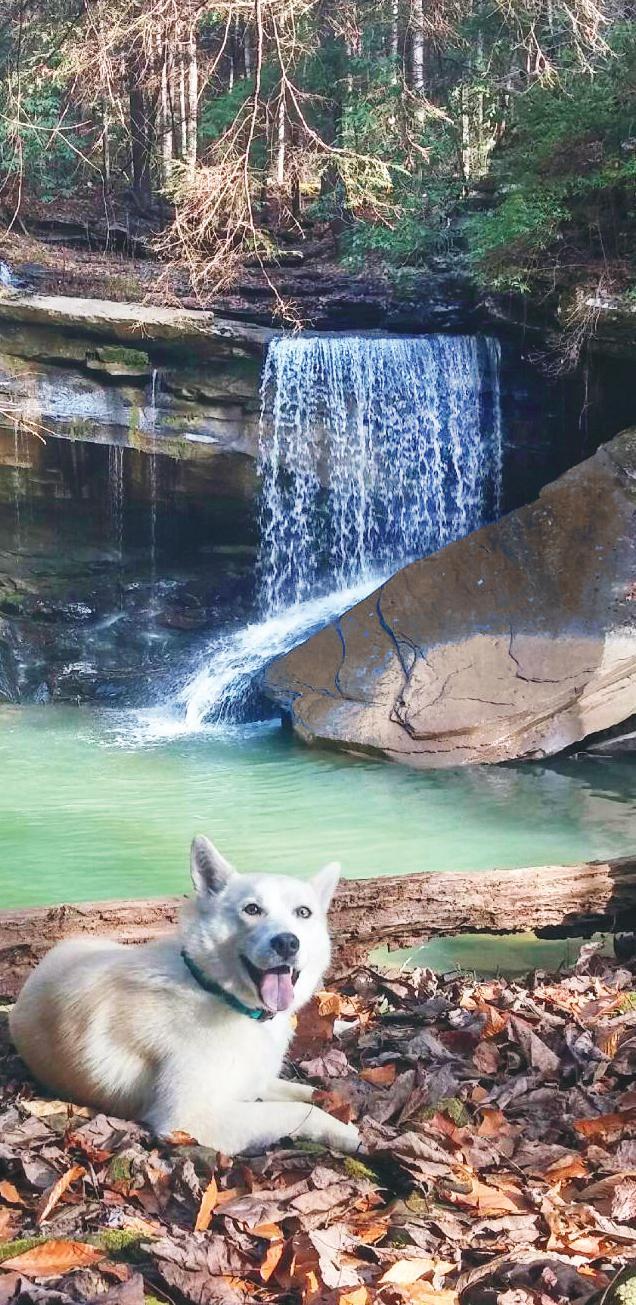
2 waterfalls of southeast tennessee On the Cover: Layla at Imodium Falls, Soddy-Daisy, TN Photo courtesy of Roger King PIKEVILLE 11 B L E D S O E «30 « DAYTON BEERSHEBA SPRINGS G R U N D Y «303 5 «7 399 GRAYSVILLE ALTAMONT SOUTH 7 CUMBERLAND STATE PARK «8 HIWASSEE WILDLIFE 3 REFUGE GRUETLI-LAAGER DUNLAP PALMER 10 «« Chickamauga COALMONT S E Q U A T C H I E Lake 11 9 GRUNDY LAKES STATE PARK SODDY-DAISY TRACY CITY «108 GRUNDY FOREST 2 «319 STATE NATURAL AREA H A M I L T O N MONTEAGLE WHITWELL LAKESITE FOSTER FALLS PARK 1 CHESTER HARRISON BAY FROST POWELLS CROSSROADS WALDEN «153 STATE PARK PARK M A R I O N «1124 PRENTICE COOPER STATE FOREST Tennessee 41 SIGNAL MOUNTAIN River BOOKER T. RED BANK 24 WASHINGTON STATE PARK Tennessee River CHATTANOOGA JASPER KIMBALL COLLEGEDALE «156 Nickajack «2 RIDGESIDE «60 SOUTH PITTSBURG Lake RED CLAY ORME «LOOKOUT MOUNTAIN EAST RIDGE 317 STATE NEW HOPE 134 HIST PARK ««« FRANKLIN STATE FOREST South Cumberland State Park 1. Foster Falls 2. Sycamore Falls and Bluehole Falls 3. Suter Falls and Horsepound Falls 4. Greeter Falls and Boardtree Falls 5. Laurel Falls 8 FALL CREEK FALLS STATE PARK «285 BLEDSOE STATE FOREST « Ranger Creek Falls 7. Savage Falls 8. Fall Creek Falls State Park Fall Creek Falls, Piney Creek, Cane Creek & Rockhouse Falls 9 R H E A M E I G S SPRING CITY Piney River Tennessee River «283 « DECATUR CALHOUN CHARLESTON «163 B R A D L E Y CLEVELAND «40 Watts Bar Lake «58 «28 « «74 27 «313 « Cumberland Trail 9. Big Soddy Creek Gulf Waterfall 10. Imodium & Richey Ridge Falls 11. Laurel Falls and Snow Falls 12. Upper & Lower Piney Falls 11 «305 «68 BENTON ATHENS M C M I N N NIOTA «307 ENGLEWOOD « Ocoee Lake HIWASSEE OCOEE STATE PARK ETOWAH « Hiwassee River P O L K CHEROKEE NATIONAL FOREST 64 Ocoee River «39 «315 icon legend DUCKTOWN COPPERHILL Blue Hole Leashed Dogs Welcome Easy Hike Moderate Hike Difficult Hike Restrooms «123 Cherokee National Forest 13. Benton Falls 14. Gee Greek Falls 15. Coker Creek Falls 16. Turtletown Falls Come explore the falling waters that have sculpted Southeast Tennessee s scenic landscape. There s just no better way to experience the region s lush green scenery than by sitting on a warm boulder in the misty realm of a waterfall or hiking alongside a cascading creek. Waterfall Wonder features some of the most scenic and accessible waterfalls on public lands in Southeast Tennessee, from impressive veils of water plunging over cliffs to cascades tumbling over rocky outcroppings. This guide spans the 10 counties of Southeast Tennessee, from South Cumberland State Park on the Cumberland Plateau, north to Fall Creek Falls State Park, south along sections of the Cumberland Trail in Dayton and the Greater Chattanooga Area, and east to the Cherokee National Forest. waterfall safety Please be cautious when visiting area waterfalls: Wear stable shoes and avoid slippery rocks or crossing in dangerous places. Keep children a safe distance from dangerous ledges and do not lean over ledges to view waterfalls. Do not jump off waterfalls or dive into pools of water because of dangerous unseen objects below the surface, including logs and boulders. Black bears reside in the wooded areas of Southeast Tennessee, especially the Cherokee National Forest. Before you set out, learn what to do if you unexpectedly encounter a bear. For more information, visit: Keep in mind that most waterfalls are located in remote locations without cell phone coverage.

 Foster Falls Small Wild Area along Fiery Gizzard Trail Sequatchie, TN (Marion Co.")
3 waterfalls within south cumberland state park South Cumberland State Park is composed of 30,845 acres in nine separate sections of the park. Part of the Cumberland Plateau, the area features spectacular waterfalls, blue holes, hiking trails, rock climbing and backcountry camping. South Cumberland State Park Visitor Center US-41 Monteagle, TN Open Mon. through Sun. 8 a.m. to 4 p.m. CST Photo credit: Bob Butters 1 Foster Falls (60 feet) Foster Falls Small Wild Area along Fiery Gizzard Trail Sequatchie, TN (Marion Co.) Foster Falls is a spectacular 60-foot waterfall plunging into a deep pool of water. It s a quick and easy walk along a handicapped-accessible trail to the overlook at Foster Falls. From there, a more difficult trail leads to a suspension bridge at the base of the falls (1 mile round-trip). Backcountry camping at Father Adamz Campground off the Climber s Loop Trail and vehicle camping at Foster Falls. Reservations: From Chattanooga, take I-24 W to TN-28 N in Jasper (exit 155). Follow signs for US-41 N/TN-150 toward Tracy City. Follow TN-150 to the top of the plateau and proceed 3 miles to Foster Falls Road on the left, which leads to the Foster Falls parking lot ,


4 2 Sycamore Falls (12 feet) and Bluehole Falls (9 feet) Grundy Forest State Natural Area along Fiery Gizzard Trail Tracy City, TN (Grundy Co.) This moderate 2.6-mile round-trip hike starts as the Grundy Day Loop and takes you past Bluehole Falls, Black Canyon Cascades and some interesting geologic formations. Take the short 0.6-mile spur trail (Fiery Gizzard Trail) to arrive at Sycamore Falls. Take a dip in swimming holes at both waterfalls. From Chattanooga, take I-24 W to exit 135 in Monteagle and continue right. Turn right to follow US-41 S toward Tracy City. Follow signs to Grundy Forest State Natural Area parking lot on right. GPS Waypoints: , , Suter Falls (50 feet) and Horsepound Falls (25 feet) Savage Gulf State Natural Area at Collins Gulf Near Gruetli-Laager and Palmer, TN (Grundy Co.) From the parking area trailhead, take a short access trail and turn left on the Collins Gulf Trail for a challenging 2-mile round-trip hike to Suter Falls. Watch for some interesting rock shelters and high bluffs along the way. From Suter Falls, continue on the Collins Gulf Trail an additional 3.6 miles (round-trip from Suter Falls) into the gorge to arrive at Horsepound Falls, where local residents hid their ammunition and horses from the advancing Union Army during the Civil War. From Chattanooga, take I-24 W to exit 155 (Jasper). Take TN-28 N to Whitwell. Turn left on TN-108 N toward Gruetli-Laager. Turn right on 55th Ave. Look for signs for Collins Gulf parking area on the left. GPS Waypoints: , ,
 Firescald Creek spills over Greeter Falls, which consists of a 15-foot upper waterfall and 50-foot lower waterfall. It s a 2.")

5 4 Greeter Falls (50 feet) and Boardtree Falls (30 feet) Savage Gulf State Natural Area in Stone Door Area Altamont, TN (Grundy Co.) Firescald Creek spills over Greeter Falls, which consists of a 15-foot upper waterfall and 50-foot lower waterfall. It s a 2.25-mile round-trip hike along the Greeter Falls Loop Trail to experience both the upper and lower sections of Greeter Falls, as well as Boardtree Falls. A metal spiral staircase descends the bluff, leading to the lower section of Greeter Falls. Watch for steep ledges along the trail. From the Greeter Falls Loop Trail, a 1-mile (round-trip) spur trail on the right heads down to a blue hole along Firescald Creek. From Chattanooga, take I-24 W to exit 135 in Monteagle and continue right. Turn right to follow US-41 S approx. 5.5 miles toward Tracy City. Turn left on TN-56 N and travel 16 miles. After passing through Altamont, look for the Greeter Falls sign on the right. Follow that road for less than a mile to the Greeter Falls parking lot. GPS Waypoints: , , Photo credit: Bob Butters 5 Laurel Falls (25 feet) Savage Gulf State Natural Area in Stone Door Area Beersheba Springs, TN (Grundy County) It s a short 0.3-mile round-trip hike from the Stone Door Ranger Station to view the overlook of Laurel Falls, where Laurel Creek drops 25 feet off a bluff with a hollowed-out amphitheater behind it into a pool of blue water. A long wooden staircase leads to the base of the falls. Look for remaining foundation stones from a mill that once operated along the creek. From Chattanooga, take I-24 W to exit 135 in Monteagle and continue right. Turn right to follow US-41 S approx. 5.5 miles toward Tracy City. Turn left on TN-56 N toward Coalmont. Turn right on Stone Door Rd. in Beersheba Springs and travel 1.5 miles to Stone Door Ranger s Station parking lot on left ,


6 6 Ranger Creek Falls (30 feet) Savage Gulf State Natural Area in Stone Door Area Beersheba Springs, TN (Grundy Co.) From the Stone Door Ranger s Station, it s a rugged 6.6-mile round-trip hike into the Big Creek Gorge to see Ranger Creek Falls, the widest waterfall in South Cumberland State Park. Take the Stone Door Trail to the Big Creek Gulf Trail. At the intersection of Stone Door Trail and Big Creek Gulf Trail, check out Great Stone Door Bluffs and walk down through the Great Stone Door Staircase. At the bottom of the Staircase, follow the trail 2 miles to Ranger Creek Falls Trail, which leads to the waterfall. From Chattanooga, take I-24 W to exit 135 in Monteagle and continue right. Turn right to follow US-41 S approx. 5.5 miles toward Tracy City. Turn left on TN-56 N toward Coalmont. Turn right on Stone Door Rd. in Beersheba Springs and travel 1.5 miles to Stone Door Ranger s Station parking lot on left , Photo credit: Bob Butters Photo credit: Bob Butters 7 Savage Falls (30 feet) Savage Gulf State Natural Area in Savage Gulf Area Palmer, TN (Grundy Co.) From the Savage Gulf Ranger Station, it s a 3.4-mile round-trip hike to Savage Falls. Along the way, enjoy two swinging bridges across Boyd Branch and Savage Creek. Take the Savage Day Loop Trail, turn left at the Loop Junction, and turn left on the South Rim Trail, which leads to Savage Falls. Enjoy a blue hole at the base of the falls. Savage Falls Campground offers eight backcountry camping sites within 100 yards from the falls. Reservations: From Chattanooga, take US-27 N to TN-111 N. After 47 miles, turn left on TN-399 W to the Savage Gulf Ranger s Station parking lot ,


7 waterfalls at fall creek falls state park Fall Creek Falls State Park is Tennessee s largest and mostvisited state park, encompassing more than 26,000 acres atop the Cumberland Plateau. The park is located 18 miles west of Pikeville and 11 miles east of Spencer. In addition to Fall Creek Falls, the tallest waterfall in the eastern United States, the park features more than 34 miles of trails and multiple waterfalls, an inn, restaurant, cabins and campsites, a golf course, pool, horseback riding and a nature center. Fall Creek Falls State Park 2009 Village Camp Rd. Spencer, TN Fall Creek Falls (256 feet) Fall Creek Falls State Park Pikeville, TN (Bledsoe Co.) At 256 feet, Fall Creek Falls is the tallest waterfall in the eastern United States. It s a quick and easy walk to the overlook at Fall Creek Falls. The Fall Creek Falls Trail is a more challenging 3-mile loop trail that leads to the bottom of the falls. Other trails throughout the park offer views of Fall Creek Falls and other waterfalls, including Piney Falls, Cane Creek Falls, Cane Creek Cascades and Rockhouse Falls. From Chattanooga, take US-27 N to TN-111 N. Travel 50 miles and turn right on TN-284 E to the entrance of Fall Creek Falls State Park ,

 Connects to the Cumberland Trail Soddy-Daisy, TN (Hamilton Co.")
8 waterfalls of the cumberland trail The Cumberland Trail traverses 190 miles of the Cumberland Plateau, spanning 11 counties in East Tennessee. This developing trail system, which currently features 15 segments, offers hikers access to remote areas with spectacular overlooks, waterfalls and wilderness experiences that are trademarks of the southeastern United States. Cumberland Trail State Park 220 Park Rd. Caryville, TN Big Soddy Creek Gulf Waterfall (30 feet) Connects to the Cumberland Trail Soddy-Daisy, TN (Hamilton Co.) It s an easy 2-mile round-trip hike along an old mining road to this wet-weather waterfall that tumbles over a rock wall into Big Soddy Creek. This family-friendly trail follows alongside the cascading river and includes stops for wading and skipping rocks. The waterfall is not visible during dry periods. From Chattanooga, take US-27 N to Hwy. 111 N. Take Back Valley Rd. exit and turn left on Back Valley Rd. Pass under highway and follow signs to parking area on the right. GPS Waypoint ,
 It s a short and easy walk from parking to view Richey Ridge Falls, an 18-foot wet-weather cascade along the Cumberland Trail.")

9 10 Richey Ridge Falls (18 feet) and Imodium Falls (25 feet) The Cumberland Trail: Possum Gorge Segment Soddy-Daisy, TN (Hamilton Co.) It s a short and easy walk from parking to view Richey Ridge Falls, an 18-foot wet-weather cascade along the Cumberland Trail. From Richey Ridge Falls, continue on for a more challenging 9-mile round-trip hike to Imodium Falls (aka Little Possum Creek Falls). From Chattanooga, follow US-27 N through Soddy-Daisy. Follow TN-111 N and proceed 5 miles to the Jones Gap Rd. exit and turn right. Immediately turn right on Heiss Mountain Rd., and travel 0.5 mile. Look for the trailhead with Cumberland Trail signage. Parking is available along the side of the road. GPS Waypoints: , , Laurel Falls (80 feet) and Snow Falls (35 feet) The Cumberland Trail: Laurel-Snow State Natural Area Dayton, TN (Rhea Co.) The Laurel-Snow section of the Cumberland Trail is an area of gorges cut into Walden s Ridge, part of the Cumberland Plateau. From the trailhead, it is 1.7 miles to the split where the Laurel Falls spur trail forks to the right and the Snow Falls spur trail forks to the left. Take the steep Laurel Falls spur trail 0.7 miles to the base of the falls and continue on to the top of the falls and to two overlooks for a 6.6-mile round-trip hike from the trailhead. The hike to Snow Falls, which is located at the end of the Snow Falls spur trail, is a moderate 9.6 mile hike (round-trip) from the trailhead. From Chattanooga, take US-27 N toward Dayton. Turn left on Walnut Grove Rd. Continue 0.7 mile and turn left on Back Valley Rd. In 0.7 mile, turn right on gravel road for Laurel- Snow State Natural Area. Proceed 1 mile to the parking lot on Richland Creek Rd. GPS Waypoints: , ,

 This 2.2-mile round-trip trail will take you to where Little Piney Creek plunges some 80 feet over Upper Piney Falls into a pool below, and then drops another 40 feet over Lower Piney Falls.")
10 waterfalls within the cherokee national forest Home to the Ocoee and Hiwassee rivers, the Cherokee National Forest, the largest tract of public land in Tennessee, is a landscape defined by cascades, rapids and scenic waters. The Forest also offers numerous opportunities for hiking, paddling, biking and camping. Ocoee Ranger District 3171 US-64 Benton, TN fs.usda.gov/main/cherokee/home Photo credit: Ronnie Phipps 12 Upper Piney Falls (80 feet) and Lower Piney Falls (40 feet) The Cumberland Trail: Piney Falls Designated State Natural Area Grandview, TN (Rhea Co.) This 2.2-mile round-trip trail will take you to where Little Piney Creek plunges some 80 feet over Upper Piney Falls into a pool below, and then drops another 40 feet over Lower Piney Falls. From the parking lot, follow the trail along an old dirt road for about a half mile until you come to a fork in trail. The trail to the right leads to the ledge overlook of Upper Piney Falls (use caution on ledges!) and a trail to the left leads to the base of the falls down in the gorge. These two trails eventually connect if you wish to hike the full loop. The Lower Falls is not easily accessible by the main trail for viewing. From Chattanooga, follow US-27 N to TN-68 N in Spring City. Follow TN-68 N into the Grandview Community. Look for a sign for Piney Falls State Natural area and turn left on Firetower Rd. Travel 1.5 miles to the parking area and trailhead on the right ,
 Gee Creek Trail #191, which lies almost entirely within the congressionally designated Gee Creek Wilderness, is an easy 2.")

11 14 Gee Creek Falls (25 feet) Cherokee National Forest: Gee Creek Wilderness Benton, TN (Polk Co.) Gee Creek Trail #191, which lies almost entirely within the congressionally designated Gee Creek Wilderness, is an easy 2.6-mile round-trip hike leading to a gorgeous double waterfall that plunges into a deep pool. Look for a concrete water divider within the creek that was used in the late 1800s to wash mined silica during the region s mining era. This is a hiking-only trail. Recreation in congressionally designated Wilderness is intended to be primitive in nature and group size is limited to 12 people. For more information, visit From Chattanooga, take I-75 N to exit 20 (Cleveland) and turn right on US-74 E. Travel US-74 E for 6 miles to US-64 E. Take US-411 N exit and travel approximately 14 miles. In Delano, turn right on Gee Creek Road and continue for 2.2 miles to the signed trailhead, just before a left curve. Paved road becomes dirt road ending at FS Trail #191 trailhead parking lot. Photo credit: Jim Caldwell , Benton Falls (65 feet) Cherokee National Forest: Chilhowee Recreation Area Benton, TN (Polk Co.) Located in the Chilhowee Recreation Area near the Ocoee River, the drive to Benton Falls following the Ocoee Scenic Byway is just as scenic as the waterfall, offering overlooks of Sugarloaf Mountain and Parksville Lake. From the McCamy Lake parking lot, take Benton Falls Trail #131 for an easy 3-mile round-trip hike to this stunning 65-foot-high waterfall. Cool off from your hike in the shallow pools at the bottom of the falls. From Chattanooga, take I-75 N to exit 20 (Cleveland) and turn right on US-74 E. Travel US-74 E for approx. 6 miles to US-64 E. From US-64 E, follow the Ocoee Scenic Byway and turn left on FS Road 77. Travel approx. 7.5 miles to the Chilhowee Recreation Area (McCamy Lake). Trail begins to the left of the bathhouse. Day use fee: $ ,

 and turn right on US-74 E. Travel US-74 E for 6 miles to US-64 E and continue to Ducktown. Take TN-68 N to Turtletown and turn left on Farner Rd.")
12 16 Turtletown Falls (Upper 30 feet, Lower 40 feet) Cherokee National Forest Turtletown, TN (Polk Co.) Turtletown Creek Trail #185 is a moderate 3.5 mile round-trip loop trail that follows Turtletown Creek and loops back to Shinbone Ridge. The hike features scenic views of the Hiwassee River and overlooks of two major waterfalls: Lower Turtletown Falls (40 ) and Turtletown Falls (30 ). From Chattanooga, take I-75 N to exit 20 (Cleveland) and turn right on US-74 E. Travel US-74 E for 6 miles to US-64 E and continue to Ducktown. Take TN-68 N to Turtletown and turn left on Farner Rd. Travel approx. 2.8 miles to the gravel FS Road #1166 on the left (not marked from the road). Once on FS Road #1166, continue approx. 1.5 miles until the road dead-ends at the FS Trail #185 trailhead. GPS Waypoint , Photo credit: Tennessee Overhill Heritage Association 15 Coker Creek Falls (45 feet) Cherokee National Forest Coker Creek, TN (Polk Co.) Take Coker Creek Trail #183 for a 3-mile round-trip hike to Coker Creek Falls, a series of cascades ranging from 5 to 45 feet. The trail follows Coker Creek, a shallow creek perfect for summertime splashing. From Chattanooga, take I-75 N to exit 60 (Sweetwater). Turn right on TN-68 S and drive approx. 35 miles to Coker Creek. Turn right on Ironsburg Road (County Rd. 628) and proceed approx miles. Turn left on FS Road 2138 and follow downhill for approx miles to the Coker Creek Falls trailhead parking lot. GPS Waypoint ,

13 produced by sedev.org The Southeast Tennessee Tourism Association is a part of Economic & Community Development within the Southeast Tennessee Development District (SETDD) based in Chattanooga, TN. We work with partners within the 10 counties of Southeast Tennessee and the Tennessee Department of Tourist Development to promote economic development through tourism, which is the second-largest industry in Tennessee. To learn more about SETDD, visit
Play Outside in Southeast Tennessee SoutheastTennessee.com
 Outdoor Adventure Guide Play Outside in Southeast Tennessee SoutheastTennessee.com Table of Contents Southeast Tennessee Map... 3 Regional Outdoor Information Centers... 4 Caves & Rocks... 5 Gardens &
Outdoor ADVENTURES. World-Class Adventures on Land, on Water, and in the Air OUTDOOR ADVENTURES
 OUTDOOR ADVENTURES Outdoor ADVENTURES World-Class Adventures on Land, on Water, and in the Air DID YOU KNOW? LOOKOUT MOUNTAIN HANG GLIDING In 2017, the Tennessee State Park system celebrated its 80th anniversary.
GIFFORD PINCHOT NATIONAL FOREST
 GIFFORD PINCHOT NATIONAL FOREST 9341 Wright Meadow 93 Spencer Meadow Spencer Butte 4247' 30 30A 19 24 80 31C Lewis River Lower Falls 5 Quartz Creek 90 Taidnapam Falls Upper Falls 31 Spencer Peak 3861'
GUIDE TO THE GREAT EASTERN TRAIL IN TENNESSEE
 GUIDE TO THE GREAT EASTERN TRAIL IN TENNESSEE FIRST EDITION, SEPTEMBER 2011 Covers Section TN1 Base of Lookout Mountain to Soddy Daisy, TN THIS GUIDE IS NOT FOR SALE OR RESALE Guide To The Great Eastern
Hiking Las Vegas.com
 Hike: Mt. Wilson via First Creek Canyon route Trailhead: First Creek marked Distance: 10 miles up and back Elevation gain: 3,400 feet Elevation of Peak: 7,070 feet Time: 7 to 9 hours (up and back) Difficulty:
ABOUT THE PARKS NANTAHALA NATIONAL FOREST MOUNTAINS NATIONAL PARK CHEROKEE NATIONAL FOREST PISGAH NATIONAL FOREST GREAT SMOKY HIKING TRAILS
 ABOUT THE PARKS GREAT SMOKY MOUNTAINS NATIONAL PARK NANTAHALA NATIONAL FOREST CHEROKEE NATIONAL FOREST PISGAH NATIONAL FOREST GREAT SMOKY MOUNTAINS NATIONAL PARK Straddling the border between North Carolina
Rogue Gorge (Mt. Stella) Roadless Area-- T30S R3E (primarily in portions of Sections 23, 26, 33, 34 & 35)
 Roadless Area-- T30S R3E (primarily in portions of Sections 23, 26, 33, 34 & 35)") Rogue Gorge (Mt. Stella) Roadless Area-- T30S R3E (primarily in portions of Sections 23, 26, 33, 34 & 35) Rogue River-Siskiyou National Forest--High Cascades Ranger District Upper, higher elevation trail
Rogue Gorge (Mt. Stella) Roadless Area-- T30S R3E (primarily in portions of Sections 23, 26, 33, 34 & 35) Rogue River-Siskiyou National Forest--High Cascades Ranger District Upper, higher elevation trail
Crystal Lake Area Trails
 Lake Area Trails Welcome to the Lake area of the Big Snowy Mountains! This island mountain range in central Montana features peaks reaching to 8,600 feet and long, high ridges from which vistas of the
SPRING 2018 TRIPS FEBRUARY
 SPRING 2018 TRIPS FEB. 18 (Sunday) ( Beginner Adv.) CLIMBING FEBRUARY $ Rec Members / $ Rec Non Kings Bluff, TN $33 / $36 Sign-up by: Friday, Feb. 9 Pre-Trip Meeting: Tuesday, 2/13 at 5:00 pm FEB. 10 (Saturday)
Cataloochee. Fishing Species Rainbow Trout and Brook Trout. Recreation
 Cataloochee River Information The Cataloochee River is located in the historic Cataloochee Valley--a relatively remote part of Smoky Mountain National Park. The campground is a secluded setting and offers
Cherokee Hiking Club Trail Blurb
 Cherokee National Forest Trail #164 Distance: 6.2 miles Elevation Change: 2280 feet High Point: 3692 feet (Waucheesi Mountain) Low Point: 1412 feet (Wildcat Creek) Trail Rating: Moderately Strenuous (NW
Black Hill Regional Park, Little Seneca Lake
 Black Hill Regional Park, ittle Seneca ake ittle Seneca ake, in Black Hill Regional Park, is a reservoir created after a previous drought struck the Washington area. The park is under Maryland-National
Other Agencies and Organizations
 Daniel Boone National Forest 1700 Bypass Road WInchester, KY 40391 859-745-3100 Location Northern terminus is near Morehead, Kentucky. Southern terminus is located in the Big South Fork NRRA in Tennessee.
Eagle Rock Loop Ouachita National Forest Page 1 of 8
 EAGLE ROCK LOOP Eagle Rock Loop Ouachita National Forest Page 1 of 8 Hiking: Biking: Equestrian: Trail Highlights: This trail offers the longest loop trail in Arkansas. A combination of the Little Missouri,
C E N T R A L C A T S K I L L S
 120 C E N T R A L C A T S K I L L S Central Catskills Once out of the southern parts of the Catskills, the Long Path enters the more well traveled and civilized regions. The trail joins the Devil s Path,
TENNESSEE MOUNTAIN LIVING
 NOVEMBER 2016 Featuring Jasper Highlands TNLand.com END of the YEAR December 26th to Land Sale December 31st See back cover for more info... TENNESSEE MOUNTAIN LIVING JASPER HIGHLANDS - TENNESSEE'S MOST
Driving Time: 3 hours (allow extra time for stops)
") Scenic Byways loop This journey takes visitors through the eastern edge of Mt. Rainier National Park and along two of Washington s most beloved scenic byways, the Chinook Byway and the White Pass Scenic
Scenic Byways loop This journey takes visitors through the eastern edge of Mt. Rainier National Park and along two of Washington s most beloved scenic byways, the Chinook Byway and the White Pass Scenic
playwinterpark.com Off The Beaten Path Hikes Hiking Recommendations for the Adventurous Hiker
 playwinterpark.com Off The Beaten Path Hikes Hiking Recommendations for the Adventurous Hiker Hike: Devil s Thumb (difficult) Length: 3.93 miles one-way Elevation: Trailhead 9609 Destination 12,236 Trailhead
GOLDEN EARS PROVINCIAL PARK
 GOLDEN EARS PROVINCIAL PARK Trail Information as of October 10 th 2015 Do not underestimate the mountainous wilderness of Golden Ears Provincial Park. The combination of rugged terrain and rapidly changing
Trail Phasing Plan. Note: Trails in the Clear Creek Canyon area (Segments will be finalized in the future to minimize wildlife impacts
 Note: Trails in the Clear Creek Canyon area (Segments 2 5 and a future JCOS connection) will be finalized in the future to minimize wildlife impacts Trail Phasing Plan P Parking 3 Easy Trail Intermediate
Visitor s Center 110 E. Meeting Street Morganton, NC
 5 unique trails worth checking out! Cross-Country skiing! No snakes! Don t sweat it! www.discoverburkecounty.com Visitor s Center 110 E. Meeting Street Morganton, NC Photo of Table Rock by Justin Costner
Difficult Run Stream Valley Park
 Difficult Run Stream Valley Park The more intense mountain bikers have known about for Difficult Run for some time. Equestrians have known it longer. Eight miles of unpaved trail, the Rails to River Trail
Blue Ridge Hiking Club Hike List July- September 2016
 Blue Ridge Hiking Club Hike List July- September 2016 Saturday, July 2, Elk Knob: 3.8 mile round trip with 900 ft. gain in elevation. Spectacular views at the summit. The trails are mostly moderate, but
Telluride-to-Moab Alternative Singletrack Options
 Telluride-to-Moab Alternative Singletrack Options Day 1 Day 1 Alternate 1: Galloping Goose to Deep Creek. 18.4 miles, ascent 3,530ft, descent 1,388ft. This is fun, flowey, moderate to intermediate singletrack
Little Grand Canyon near Pomona, Illinois
 Little Grand Canyon near Pomona, Illinois Below: View of the trail and the terrain created using the Map My Hike app Below: Summary of the hike created using the Map My Hike app Presented by: Jennifer
CONTENTS. 31 THE TRAILS See next page for a complete listing of all trails and a locator map. Trail descriptions begin on page 31.
 CONTENTS Page Topic 6 Trail List 7 Trail Locator Map 8 Trails Listed by Dificulty 9 Trail Ratings Deined 11 INTRODUCTION 11 Using this Book 12 The Right Trail for You 13 About Moab 15 Utah OHV Laws and
Lava Mountain Trail Distance: Elevation Range: Trail Type: Difficulty: Season: Driving Distance: Driving Time: USGS Maps: Pros Cons
 Lava Mountain Trail Distance: 13.4 miles (including the side trip to North Star Lake) Elevation Range: 5900'-8330' Trail Type: singletrack Difficulty: moderate Season: late June-October Driving Distance:
Bureau of Land Management Public Lands Guide Northwest District
 Bureau of Land Management Public Lands Guide Northwest District NORTHWEST Fee Site Restrooms Picnic Sites Developed Campgrounds Farmington Field Office (505) 564-7600 Alien Run Mountain Bike Trail Angel
Location: Height: Access: Distance: Elevation: Season: Difficulty: Lat/Long: Directions:
 Upper Eagle Falls Upper Eagle Falls (~20 ft.) is a short hike up from the roadside at the Eagle Falls picnic area. It is very difficult to get a parking spot here during the day, so it is recommended to
Tiger Mountain State Forest:
 98 60 hikes within 60 miles: SEATTLE 20 Tiger Mountain State Forest: West Tiger Mountain Three Loop i KEY AT-A-GLANCE INFORMATION Length: 5.1 miles round-trip Configuration: Loop Difficulty: Moderate difficult
Asheville & WNC Hikes
 Asheville & WNC Hikes Amazingly, we have 3,000+ miles of free public hiking trails near Asheville, including 1,600 miles in the Pisgah and Nantahala National Forests, 850 miles in Great Smokey Mountains
Trail Beginning Elevation: 7553 ft The Poison Creek Trailhead is located at the end of National Forest Road 646E (NF-646E).
.") West Mountain Trails Poison Creek Trail #134 Length: 2.9 miles (4.7 km) Difficulty Horseback: A good trail for the first time west mountain rider, some steep sections Hiking: Most Difficult USGS Maps:
West Mountain Trails Poison Creek Trail #134 Length: 2.9 miles (4.7 km) Difficulty Horseback: A good trail for the first time west mountain rider, some steep sections Hiking: Most Difficult USGS Maps:
Stein Valley Nlaka pamux Heritage Park
 Stein Valley Nlaka pamux Heritage Park - Trail Information Update and Winter Advisory November 2017 March 2018 Welcome to Stein Valley Nlaka pamux Heritage Park! **This trail update is to inform park users
The Cherokee Hiker. December 2010 Volume 26, Issue 12. Cherokee Hiking Club, Inc Varnell Road Cleveland, TN
 The Cherokee Hiker December 2010 Volume 26, Issue 12 ~CHC Hike Calendar~ Cherokee Hiking Club, Inc. 2349 Varnell Road Cleveland, TN 37311 www.cherokeehikingclub.org December 4, 2010 Saturday. Big Frog
2. Buck s Overnight Lodge - A nice place to stay on 300 acres.
 FENTRESS COUNTY Major Draws to the area: A. The horse back riding trails through the Big South Fork B. Sgt Alvin York C. The Hwy 127 Longest Yard Sale through 5 states. Fentress County started it and hosts
Route Combo) Mt. Bierstadt - Bierstadt, Sawtooth, Evans
 Mt. Bierstadt - Bierstadt, Sawtooth, Evans") Climbing 14ers can be very dangerous, please read the Mountaineering Safety Page and make sure you have a map+compass and can use them effectively, without the help of electronic devices. Route Combo)
Climbing 14ers can be very dangerous, please read the Mountaineering Safety Page and make sure you have a map+compass and can use them effectively, without the help of electronic devices. Route Combo)
Mazatzal Wilderness Trail Maintenance and Exploration
 Mazatzal Wilderness Trail Maintenance and Exploration March 15-19 (Wednesday - Sunday) Difficulty: Beginner Camping: Car Camping Mileage: Wednesday ~4 miles Thursday ~4-6 miles Friday ~4-6 miles Saturday
A DESERT CAMPING GUIDE FOR ANZA BORREGO DESERT STATE PARK
 A DESERT CAMPING GUIDE FOR ANZA BORREGO DESERT STATE PARK With over 500,000 acres of beautiful terrain, Anza Borrego Desert State Park offers endless opportunities for Boy Scout Troops, Venture Crews and
Blue Ridge Hiking Club - First Quarter 2018 Hikes
 Blue Ridge Hiking Club - First Quarter 2018 Hikes Monday, Jan 1: Trout Lake to Manor House & Figure 8 Trail: Meet at Trout Lake parking lot, at 9:30. (1st exit left off Parkway just south of Cone Manor
Southern Utah University Hike Brochure
 Southern Utah University Hike Brochure Taylor Creek Trail Twenty minutes from Cedar City Red Hollow An hour and a half from Cedar City Fees: Entrance fee to Kolb Canyon Length: 5 miles round trip Length:
Griffith Park Trail Run Trail Guide Click for
 The Griffith Park Trail Run by Hike- LosAngeles.com Griffith Park Trail Run Trail Guide Click for downloadable cell phone guide and map from EveryTrail. DISTANCE: 4.55 Miles ELEVATION: 1280' ELEVATION
Massanutten Mountain Cluster
 Massanutten Mountain Cluster Signal Knob Catback Mountain Southern Massanutten Mountain Five areas of almost 49,000 acres on the Lee Ranger District compose the Massanutten Mountain Cluster of Mountain
Tumbler Ridge Global Geopark
 Tumbler Ridge Global Geopark WILDERNESS WATERFALLS These waterfalls are in remote locations, no trails exist, and GPS is required. Not every geosite needs a hiking trail. Providing ready access to all
Hiking Las Vegas.com
 Hike: Juniper Peak up and back Trailhead: Oak Creek Canyon marked Distance: 5.5 miles round trip Elevation gain: 2,200 feet Elevation peak: 6,109 feet Time: 4 to 5 hours - Up and back Difficulty: 3 Danger
The Cherokee Hiker. March 2011 Volume 27, Issue 3. Cherokee Hiking Club, Inc Varnell Road Cleveland, TN
 The Cherokee Hiker March 2011 Volume 27, Issue 3 Cherokee Hiking Club, Inc. 2349 Varnell Road Cleveland, TN 37311 www.cherokeehikingclub.org ~CHC Hike and Events Calendar~ March 5, 2011 Saturday. Walls
LIFETIME SERVICE AWARD NOMINEE SAM H. POWELL
 LIFETIME SERVICE AWARD NOMINEE SAM H. POWELL Sam H. Powell and his wife Emilie started hiking 1955 to 1958 in the Smoky Mountains while students at the University of Tennessee in nearby Knoxville. They
NATIONAL ATV / UTV JAMBOREE RIDES
 NATIONAL ATV / UTV JAMBOREE RIDES Note: Rides range from Beginner to Advanced and will last from 2 to 3 hours or an entire day of riding. 1. DESERT RIDE (CLEAR LAKE BIRD REFUGE & LACE CURTAINS/LAVA TUBES)
Non-motorized Trail Plan & Proposal. August 8, 2014
 Town of Star Valley Ranch, Wyoming and the Star Valley Ranch Association in partnership with the USDA Forest Service, Bridger-Teton National Forest, Greys River Ranger District Non-motorized Trail Plan
OMH Trail Data / History
 Lake Sylvia Loop Ouachita National Forest (AR) This is a five-mile loop with several variations for Saturday hikes. The basic loop starts at Lake Sylvia campground and goes south to meet the Ouachita Trail
Logan Canyon Hiking Trail Guide
 C a c h e V a l l e y V i s i t o r s B u r e a u Logan Canyon Hiking Trail Guide Monique Beeley Legend Trail Location Guide WASATCH CACHE NATIONAL FOREST WILDERNESS PAVED WATER TRAILHEAD 9 Logan River
CIEC 9 PEAKS AWARD SUPPLEMENT POSSIBLE ROUTES FOR THE 9 PEAKS AWARD TRIP
 CIEC 9 PEAKS AWARD SUPPLEMENT POSSIBLE ROUTES FOR THE 9 PEAKS AWARD TRIP As you plan your trip, be aware of 3 regulations in this wilderness: 1. Camp only in designated campsites. 2. No campfires allowed.
Stephens State Park Trails
 TRAILS OF ALLAMUCHY MOUNTAIN & STEPHENS STATE PARKS Allamuchy Mountain and Stephens State Parks contain 28 marked trails providing access to diverse landscapes for walking, hiking, biking, bird-watching,
HIKING TRAILS IN THE DAHLONEGA AREA
 HIKING TRAILS IN THE DAHLONEGA AREA 22 Trails in the North Georgia Mountains within 32 miles of Dahlonega Provided by the Dahlonega- Lumpkin County Visitors Center Information compiled and produced by
The gorges of Mohican Park in Ohio create a hiker's paradise Sunday, May 22, 2011 By Bob Downing, Akron Beacon Journal
 Pittsburgh Post-Gazette The gorges of Mohican Park in Ohio create a hiker's paradise Sunday, May 22, 2011 By Bob Downing, Akron Beacon Journal Bob Downing Big Lyons Falls drops 80 feet into a shady U-shaped
The Cherokee Hiker. July 2012 Volume 28, Issue 7. Cherokee Hiking Club, Inc. 198 Crews Drive Benton TN
 The Cherokee Hiker July 2012 Volume 28, Issue 7 Cherokee Hiking Club, Inc. 198 Crews Drive Benton TN 37307 www.cherokeehikingclub.org ~CHC Hike and Events Calendar~ July 8, 2012 Sunday. Lower Hiawassee
NATIONAL ATV / UTV JAMBOREE RIDES
 NATIONAL ATV / UTV JAMBOREE RIDES Note: Rides range from Beginner to Advanced and will last from 2 to 3 hours or an entire day of riding. 1. DESERT RIDE (CLEAR LAKE BIRD REFUGE & LACE CURTAINS/LAVA TUBES)
San Luis Obispo. Bishop Peak Felsman Loop Eagle Rock Maino Open Space Poly Canyon Poly P Other Areas
 San Luis Obispo Bishop Peak Felsman Loop Eagle Rock Maino Open Space Poly Canyon Poly P Other Areas 1 JCT. ELEV. 72 400 00 0 FELSMAN LOOP GATE LOOP RIDGE 600 FENCE JCT. ELEV. 860 1000 1200 BISHOP PEAK
Cincinnati Nature Center s
 120 60 hikes within 60 miles: cincinnati 24 Cincinnati Nature Center s Rowe Woods i KEY AT-A-GLANCE INFORMATION Length: 8.9 miles Configuration: Loop Difficulty: Difficult Scenery: Forest, ponds, prairie,
Kitimat. Pacific Inland Coast. Hiking Guide Kitimat, British Columbia, Canada
 Kitimat Pacific Inland Coast Hiking Guide Kitimat, British Columbia, Canada 2010-2011 Sites and Trails Emergency Call 911 Police - Fire - Medical 2 Welcome to Kitimat This information was produced to assist
The Cherokee Hiker. MARCH 2019 Volume 36, Issue III. Cherokee Hiking Club, Inc. 198 Crews Drive Benton TN
 The Cherokee Hiker MARCH 2019 Volume 36, Issue III Cherokee Hiking Club, Inc. 198 Crews Drive Benton TN 37307 www.cherokeehikingclub.org CHC Hike and Events Calendar. Recent Hike and Event Calendar. FEBRUARY
BRYCE CANYON COUNTRY. A twisted tree endures rugged life on the rim of the Paunsaugunt Plateau.
 BRYCE CANYON COUNTRY Grand Staircase - Paunsaugunt Plateau Scenic backways itinerary A twisted tree endures rugged life on the rim of the Paunsaugunt Plateau. Travel to Bryce Canyon Country. Lodging check-in,
Durango. Durango Whitewater Park
 High Adventure Along Colorado s Million Dollar Highway Durango If you re looking for a multi-day trip of Jaw-dropping adventure in the Colorado mountains look no further! This guide outlays 4 days through
Hiking Trail Descriptions
 Hiking Trail Descriptions For ye shall go out with joy. And be led forth with peace. The mountains and the hills shall break forth before you in singing. And all the trees of the fields shall clap their
LOWER SPRING CANYON - CAPITOL REEF
 LOWER SPRING CANYON - CAPITOL REEF Rating: Moderate Hike Length: 5-7 hours (10-11 miles) Gear: Standard Hiking Gear Maps: Fruita, UT; Twin Rocks, UT; Water: A filterable spring a bit over 1/2 way. Recommend
The Cherokee Hiker. APRIL 2019 Volume 36, Issue IV. Cherokee Hiking Club, Inc. 198 Crews Drive Benton TN
 The Cherokee Hiker APRIL 2019 Volume 36, Issue IV Cherokee Hiking Club, Inc. 198 Crews Drive Benton TN 37307 www.cherokeehikingclub.org CHC Hike and Events Calendar. Recent Hike and Event Calendar. MARCH
Bryce Canyon Country ATV Multi-Day Itinerary
 Bryce Canyon Country ATV Multi-Day Itinerary Look for more trail information and maps on these web-sites listed below. www. Casto Canyon Kick off your ATV adventure with this 36 mile round-trip ride through
beach. Make the ford and follow the trail out to the junction with Red Creek Tr in an open grassy area.
 Description: This is a moderate to slightly strenuous 22.8 mile backpack (add 2.6 miles if you do the packless out and back to the Lion s Head) that will have you exploring nearly every thing that is The
Photographing Upper Peninsula Waterfalls
 Photographing Upper Peninsula Waterfalls Tod Poirier Freelance Photographer Photography is one of my passions. The following spread showcases several Upper Peninsula waterfalls. At times a single drop
Section 7: Pick Up Where You Left Off! S-Tree Road over the Todd Road
 2018 TRACE NOTES Helpful information for your adventure on Section 7 of the Hiker Challenge. Start Point S-Tree Rd. End Point Intersection Todd Rd. / Hale Ridge Rd. WEATHER DECISION Weather Alert!!!! Potential
APPENDIX F: Trail Maps Available on the Internet
 APPENDIX F: Trail Maps Available on the Internet There are over 25 trail maps highlighting more than 150 trails within the NCHA region featured on the internet. A list of these websites are provided below:
Peak to Peak MST Segment 1A
 1 Mountains-to-Sea Trail Last Updated 1/1/2017 Peak to Peak MST Segment 1A View from the Mountains-to-Sea Trail at Clingmans Dome Photo by Danny Bernstein CLINGMANS DOME TO WATERROCK KNOB ALTERNATE ROUTE
To Wellness. To Wellness PASSPORT PASSPORT. Partners. Partners. Ashland County Health & Human Services 630 Sanborn Avenue, Ashland, WI
 Partners Ashland County Health & Human Services 630 Sanborn Avenue, Ashland, WI Ashland Bretting Center 320 4th Avenue W., Ashland, WI PASSPORT Bayfield County Health Department 117 E. 6th Street, Washburn,
Henry s Fork Angler Access. Above Mesa Falls
 Henry s Fork Angler Access Above Mesa Falls Table of Contents 1. Frome Park 2. Henry s Lake Fish Hatchery 3. Henry s Lake State Park 4. Highway 20 Bridge 5. Flat Ranch 6. Big Springs 7. Big Springs Water
Trekking at Peuma Hue
 Trekking at Peuma Hue Peuma Hue is a paradise for those who love hiking and trekking. A large variety of trails cross pristine forest, ancient rocks and stunning waterfalls with beautiful views over the
Trail Details Location
 Blind Blue Ribbon Centennial Conditions: Forest trail, with duckboards, and rope railing. Need: Blind trail activity bag, available in the camp office. None Availability: Open all seasons. Use the outdoor
Explore Montana s Glacier National Park!
 Explore Montana s Glacier National Park! Sat-Sat, July 13-20 or July 20-27, 2019 1 P a g e Trailbound Trips Explore. Dream. Discover. Discover: * Stunning hikes * Glacier-studded mountain peaks * Wildlife
EVENT SALE - March 27th to April 2nd
 EVENT SALE - March 27th to April 2nd 888-777-5758 JasperHighlands.com LOCATION With all the conveniences of a large city just 25 minutes away in Chattanooga and the friendliness of a small southern town
BryceCanyon Country. Destination Vacation Itinerary.
 BryceCanyon Country Destination Vacation Itinerary Thisisanitinerarythatoutlinesasix-dayvacationexperienceintheBryceCanyon Countryarea.Theitinerarybeginsonthewestandconcludesonthenorthwest endofscenicbyway12,butcanbeadjustedtosuitanytravelplans.
A Publication of Friends of Sleeping Bear Dunes
 A Publication of Friends of Sleeping Bear Dunes 2014, Friends of Sleeping Bear Dunes, P.O. Box 545, Empire, MI 49630 www.friendsofsleepingbear.org info@friendsofsleepingbear.org Learn more about the Friends
Note: Coordinates are provided as Universal Transverse Mercator UTM Zone U21, North American Datum 1983 (NAD 83).
.") Northern Traverse Route Description The Northern Traverse (formerly the North Rim Traverse) is an unmarked and rugged backcountry hiking route. It is known be a demanding hike, because of its terrain and
Northern Traverse Route Description The Northern Traverse (formerly the North Rim Traverse) is an unmarked and rugged backcountry hiking route. It is known be a demanding hike, because of its terrain and
BRR Leg 1 (3.9 miles, Easy)
") BRR Leg 1 (3.9 miles, Easy) Min 3901 Max 4919 Ascent +21 Descent -1031 0.0 Start (Grayson Highlands State Park Visitor Center) 3.9 Grayson Highlands State Park Office & Gate, on R (EZ 1) Leg Notes: Minimal
BRR Leg 1 (3.9 miles, Easy) Min 3901 Max 4919 Ascent +21 Descent -1031 0.0 Start (Grayson Highlands State Park Visitor Center) 3.9 Grayson Highlands State Park Office & Gate, on R (EZ 1) Leg Notes: Minimal
Arches of the. Sandflats Area. By Virginia Allen
 Arches of the Sandflats Area By Virginia Allen TABLE OF CONTENTS Introduction Dedication Road Log Arches 1. Perforated View Arch 2. Fee Booth Arch 3. Windsong Arch 4. Weird Arch 5. Resting Arch 6. Bike
Welcome to The Town of Winfield SCOTT COUNTY, TN
 SCOTT COUNTY, TN Photo Tour and Recommendations The focus of Scott County tourism is as the Tennessee Gateway to the Big South Fork National Park, which is by far the largest tourism attractor to the region.
Anderson Mt. Proposed Wilderness Additions to the Rogue-Umpqua Divide Wilderness-- T30S R3E (mostly) Sections 4 & 9, and T29S R3E Section 33
 Sections 4 & 9, and T29S R3E Section 33") Anderson Mt. Proposed Wilderness Additions to the Rogue-Umpqua Divide Wilderness-- T30S R3E (mostly) Sections 4 & 9, and T29S R3E Section 33 When the 35,701 acre Rogue-Umpqua Divide Wilderness was designated
Anderson Mt. Proposed Wilderness Additions to the Rogue-Umpqua Divide Wilderness-- T30S R3E (mostly) Sections 4 & 9, and T29S R3E Section 33 When the 35,701 acre Rogue-Umpqua Divide Wilderness was designated
Waterfall Hikes Of North Georgia By Jim Parham READ ONLINE
 Waterfall Hikes Of North Georgia By Jim Parham READ ONLINE Waterfall Hikes of North Georgia includes 60 hikes to more than 200 waterfalls, all on public land in the mountains of north Georgia. Each hike
Great Falls National Park, Virginia
 Great Falls National Park, Virginia Despite having grown-up in the area, I had not seen Great Falls until I was near an adult. I used to think places like Great Falls only existed someplace else that you
Matthiessen State Park Dells Area Hike
 90 Easy Hikes Close to Home At the south end of the hike, you ll climb on top of a mound left over from a former coal-mining operation in the park. Not far from Goose Lake Prairie, the town of Morris hosts
Great Eastern Trail Newsletter
 Great Eastern Trail Newsletter Volume 1, Number 1, January 2011 By Timothy A. Hupp Please feel free to print out or copy and distribute this newsletter Note this is the first newsletter of the Great Eastern
26 Utah s Patchwork Parkway SCENIC BYWAY CORRIDOR MANAGEMENT PLAN (SR 143)
") Natural Natural Quality applies to those features in the visual environment that are in a relatively undisturbed state. These features predate the arrival of human populations and may include geological
Natural Natural Quality applies to those features in the visual environment that are in a relatively undisturbed state. These features predate the arrival of human populations and may include geological
Welcome to Natural Bridge
 Welcome to Natural Bridge Richard R. Randolph IV www.r4capital.com Www.r4land.com 205-879-5517 Work 205-413-8805 Fax 6 Carla Circle Birmingham, AL 35213 rich@r4capital.com Introduction NATURAL BRIDGE 160
West Trails Trek Guide. Chief Pontiac Trail Credential Hikes
 West Trails Trek Guide Kensington Start Edition Chief Pontiac Trail Credential Hikes RDS.WTW.110609 WP# Dist. Accum. Dist. Accum. Feet Miles Meters Meters 1 0 0.0 0 0 2 410 0.1 125 125 3 164 0.1 150 275
The Cherokee Hiker. September 2010 Volume 26, Issue 9. Cherokee Hiking Club, Inc Varnell Road Cleveland, TN
 The Cherokee Hiker September 2010 Volume 26, Issue 9 ~CHC Hike Calendar~ Cherokee Hiking Club, Inc. 2349 Varnell Road Cleveland, TN 37311 www.cherokeehikingclub.org September 11, 2010 Saturday. Bob Bald/Hangover
CAMELBACK MOUNTAIN: CHOLLA TRAIL
 CITY OF PHOENIX :: Camelback Mountain: Cholla T rail 21 CAMELBACK MOUNTAIN: CHOLLA TRAIL IN BRIEF Camelback Mountain is the tallest point in the city of Phoenix. From the 2,704-foot summit of Camelback,
Route #2) Mt. Massive - Southwest Slopes
 Mt. Massive - Southwest Slopes") Route #2) Mt. Massive - Southwest Slopes Difficulty: Class 2 Ski: Advanced, D6 / R2 / III Exposure: Summit Elevation: Trailhead Elevation: Elevation Gain: Round-trip Length: Trailhead: County Sheriff:
Route #2) Mt. Massive - Southwest Slopes Difficulty: Class 2 Ski: Advanced, D6 / R2 / III Exposure: Summit Elevation: Trailhead Elevation: Elevation Gain: Round-trip Length: Trailhead: County Sheriff:
The Cherokee Hiker. October 2010 Volume 26, Issue 10. Cherokee Hiking Club, Inc Varnell Road Cleveland, TN
 The Cherokee Hiker October 2010 Volume 26, Issue 10 ~CHC Hike Calendar~ Cherokee Hiking Club, Inc. 2349 Varnell Road Cleveland, TN 37311 www.cherokeehikingclub.org October 2, 2010 Saturday. Coker Creek
(west) onto Charleston Boulevard. Drive 16 miles on Charleston and turn right into Red Rock
 onto Charleston Boulevard. Drive 16 miles on Charleston and turn right into Red Rock") Hike: North Peak and Ice Box Overlook up and back Trailhead: 2.5 miles up the Rocky Gap Road not mark Distance: 5 miles round trip Elevation gain: 2,694 feet Elevation Peak: 7,094 feet Time: 3 to 5 hours
Hike: North Peak and Ice Box Overlook up and back Trailhead: 2.5 miles up the Rocky Gap Road not mark Distance: 5 miles round trip Elevation gain: 2,694 feet Elevation Peak: 7,094 feet Time: 3 to 5 hours
The Cherokee Hiker. April 2010 Volume 26, Issue 4. Cherokee Hiking Club, Inc Varnell Road Cleveland, TN
 The Cherokee Hiker April 2010 Volume 26, Issue 4 ~CHC Hike Calendar~ Cherokee Hiking Club, Inc. 2349 Varnell Road Cleveland, TN 37311 www.cherokeehikingclub.org April 17, 2010 Saturday. Three Forks to
COURSE DESCRIPTION AND DIRECTIONS
 COURSE DESCRIPTION AND DIRECTIONS START TO BOUNTIFUL B (MILE 0 to MILE 17.05) From the start at East Mountain Wilderness Park, go past the green metal gate of East Mountain Wilderness Park and follow the
1. Waterfall Gully Mt Lofty. 5 Of the Best Hikes in Adelaide
 Adelaide is a beautiful city, and one of the most incredible things about Adelaide is the quality of bushwalking available on the suburban fringe. It is surrounded by the Mt Lofty Ranges, and much of the
CWMGIEDD FROM ABERCRAVE
 Abercrave to Cwmgiedd Walk Page 1 Starting from The Abercrave Inn. Grid Ref: SN 824128 From the Abercrave Inn, an 11.3km (7 miles) walk to the foothills of the Cribarth Mountain, then through forest to