Alpine Lakes Central Loop, WA
|
|
|
- Rodney Holland
- 5 years ago
- Views:
Transcription

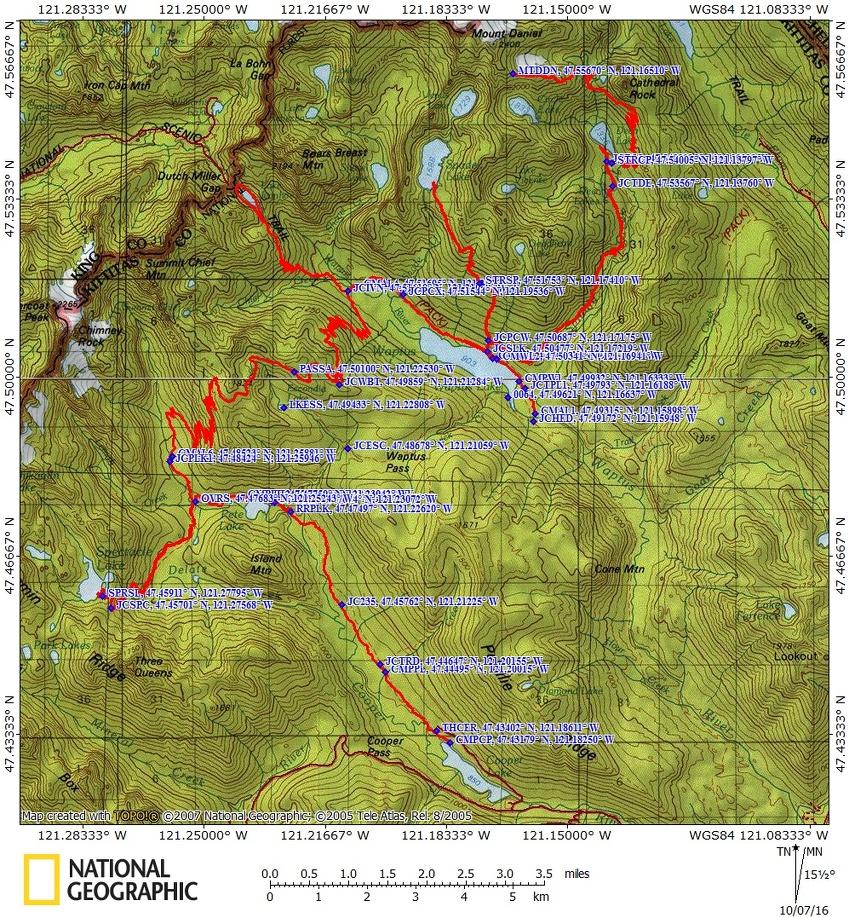
1 Alpine Lakes Central Loop, WA Vicinity Location: About 155 miles northeast of Portland, Oregon and 55 miles east of Seattle in the Okanogan- Wenatchee National Forest. Directions: From Portland drive north for about 235 miles to Cle Elum. From Seattle drive east about 80 miles to Cle Elum. From Cle Elum drive northwest on Hwy 903 about 18 miles, driving through Roslyn. Hwy 903 turns into Salmon La Sac road. Drive 17.5 miles from Cle Elum and turn left on FR 46, crossing over Cle Elum River. Follow FR 46 for 4.7 miles and turn right onto In about.7 mile, make a slight left onto FR 113 and drive about a mile to the Pete Lake trailhead, passing the horse trailer parking area. Once out of Rosyln, you should be able to follow signs to the northern end of Cooper Lake, which is where the Pete Lake Trailhead is. A Northwest Forest Pass is required to park here. A self-issuing Wilderness permit is required. There is a pit toilet in the parking lot. Trail: Multiple trails. Trail Maps: Topo Map future, Download Garmin.gpx file Length and Elevation: Alpine Lakes Central Loop Itinerary Mileage Camp elevation Ascent Descent Notes Day 1 Cooper Lake Waptus Lake Finished at 7:10 pm ,005 feet 3,600 3,400 Day 2 Waptus Lake Spade Lake Waptus Lake Finished 6:45 pm 9.9 3,115 feet 3,800 3,800 Day 3 Waptus Lake Mt. Daniel Waptus Lake Finished 7:30 pm 22 3,120 feet 7,200 7,200 Day 4 Waptus Lake Lake Ivanhoe Waptus River Camp Finished 4:30 pm 9.1 3,115 feet 2,200 2,100 Day 5 Waptus River Camp Lemai Creek Finished 4:30 pm ,130 feet 2,830 2, miles to Deep Lake, without Mt. Daniel
2 Day 6 Spectacle Lake Cooper Lake finished 7:15 pm ,803 feet 3,140 3,600 Totals: miles miles for Pamela 22,770 22, without Spectacle Lake Review: 9/12//2016 Day 0 Travel Our first day was set aside for final logistics and getting to the trailhead. Pamela had brought the large fuel canister and I convinced her to stop at REI in Olympia to change it out for the middle size that has 8 ounces of fuel. I have found that adequate for an 8 day trip of boiling water for breakfast and dinner. We also picked up another Green Trails map of the area. The next stop was Batteries Plus for a charger and camera battery and we were on our way. Looking back, we should have gotten our NW Forest Pass permit at REI. A few miles later we stopped at Starbucks for coffee and a snack. We made good time on the freeways except for one slow spot and noticed how congested southbound traffic was. Soon we were away from the urban sprawl and heading east. We got gas and took a bathroom break in Cle Elem, then stopped to take a few pictures in Rosyln. We almost got to camp and realized that we didn t have a NW Forest Pass so we drove back to Cle Elem and asked around. We found that Stewart Lodge sells them and it looks like there is someone at the front desk until late in the evening. We got to Salmon La Sac campground after dark and picked a nice single spot with plenty of room for our tents. We saw deer as we entered the campground an d 3 more were hanging around our campsite. We set up in the dark, fixed dinner, and soon went to sleep. Day 1 Cooper Lake to Waptus Lake It was a beautiful morning as we made breakfast and went through our gear and decided what to leave behind. On the way out of Salmon La Sac campground I saw a water pump. It had a crank that you turn to pump water and we each took two liters of water. One last time for nice pit toilets, got rid of our trash, and headed to the trailhead,. We arrived at Pete Lake trailhead and Pamela used the nearby toilet and we started from the well marked trailhead. The trail goes along Cooper River but the river views only last for about a mile. The trail to Pete Lake is a nice gentle walk through a lovely mix of old growth trees and younger trees. There are a few small streams along the way but we pushed on to Pete Lake where we talked to a couple of bow hunters camped on the eastern shore, just past the junction to Waptus Pass. We decided we wanted to take the easier route and not the Tired Creek trail. The junction to Waptus Lake is on the right just before you enter a large camping area about 200 feet before the lake. We enjoyed the views at the lake, filtered water, and took the short walk back to the junction. The trail to Waptus Lake soon narrows as it begins a steep climb up the hillside. There are dozens of switchbacks that lead out of the forest, through a sun parched slope, and back into the forest again. After gaining about 1,300 feet and passing some nice little waterfalls we reached the junction to Escondito Lake, dropped out packs, and walked up to the lake. It was a lot farther than we thought
3 and when we got by the lake there was a hunting camp with two canvas sided cabins with some people lounging around. We said hi and walked along a trail to the western shore of the lake for some photos. There were ripe huckleberries and blueberries and their leaves were showing fall colors. On the way back to Waptus Pass we compared this trip to the Enchantments, which has more dramatic scenery than we have seen so far. Back at the pass we donned out packs and chatted a minute with two campers who were set up by a little stream. We headed out thinking we were at the top of the pass but we were wrong. There was still quite a bit of gentle climbing and some little descents. We passed the junction for the Waptus Burn Trail which branches off to the right to the PCT and shortly after, the Polallie Ridge Trail. Continue further before finally dropping down a fairly steep trail along Quick Creek. It was some time before we finished switchbacking down to near the lake. There is a washout just where the trail veers right. It took us a minute to puzzle it out but I saw some cut logs upstream. Near the lake was another trail junction that leads a few hundred yards to some nice camps but we wanted to cross the Waptus River that night so we turned right to head southeast and walked and walked. We came to the horse ford and walked on hoping the bridge was in. We saw another signt that said the bridge was out so we went back to the horse ford and waded across the lake outlet which has a gentle flow and is less than knee deep. Pamela saw a small campsite on the left right at the ford so we stayed there because it was getting dark. The map showed some campsites on the south side of the lake but we couldn t find them. Day 2 Spade Lake dayhike -The next morning we broke camp and moved a short distance to one of the nicest spots on the lake. On the way we met Lori who lives in Portland and loves to backpack. We traded contact information and promised to get in touch. The camp has great views up and down the lake and a nice gravel beach. There was even a pit toilet near camp that wasn t too smelly. We hung out in camp until about 11 and started up a steep little trail to the Spade Lake Trailhead, off the PCT. The Spade Lake trailhead is just to the right from where the steep little trail meets the PCT. The Spade Lake trail also goes pretty much straight up the mountainside without many switchbacks. In some places the forest is quite open and the sun feels hot as you climb the south facing slopes. It doesn t look like the deadfalls get cleared out very often because we had to climb over several trunks. We met a woman and her little dog and then an elderly couple who had spent the night at Spade Lake. After climbing quite a bit, the trail goes up and down a lot and crosses a pretty little waterfall. After quite awhile you get mostly above the trees and we had great views all around. We were able to get Verizon cell phone service in this area. We followed the undulating trail to a beautiful view of Spade Lake ringed by mountain peaks. The trail seemed to stay above the lake where we were. We needed to turn back so we didn t get a chance to go to Venus Lake. If you want to continue to Venus lake, follow the eastern shore of Spade Lake and scramble up to Venus Lake. We got back to camp just before dark and remarked how few bugs there were at the lake. Pamela had not hung her food but nothing had bothered it while we were gone. We had dinner and soon dropped off to sleep. Day 3 Mt. Daniels and Deep Lake dayhike I left camp at 6am and when it was just getting light. I climbed up the terrible little trail again up to the PCT and turned right to make my way towards Deep Lake. The trail to Deep Lake is higher than our camp but there are places where the PCT dips down. There are a couple of sets of switchbacks that pass beneath some cliffs and steep hillsides. After the switchbacks there is a junction on the left for Lake Vicente followed by the junction to
4 Deep Lake. The PCT makes a 90 degree right and passes across a nice meadow with Cathedral Rock as a backdrop. Crossing the meadow brings you to a nice little stream with a couple of campsites nearby. This is the last place to get water until Peggy s Pond. There are rocks placed to allow you to get across the gently flowing stream and from there into the forest where a long series of switchbacks await. These switchbacks on the PCT are gentle but take a long time to gain elevation up to the unsigned trail junction to Peggy s Pond. The trail junction is a trail off to the left at a switchback just before the top of Cathedral Pass. Follow this trail to a tarn just below Peggy s Pond. It is possible to lose this trail and end up at a scramble. Turn around and look for the trail, it is a reasonably easy trail to Peggy s Pond. Once at the tarn, you can follow the user trails up the slopes of Mt. Daniel to the vegetation line. From here, there are a couple of ways up the slopes. Use the map to choose your route. Eventually you will get to a catwalk with great views all around. I stopped at a big rock at the 7,000 foot level, but others continue past and on to the summit. Note that I was able to get Verizon LTE service above Peggy s Pond. On the way back down I stopped at Peggy s Pond and filtered more water and took beautiful photos of Cathedral Rock reflected in Peggy s Pond. From there it was back down the switchbacks to Deep Lake meeting several PCT through hikers along the way. I like the patterns of all the logs that jam the outlet of Deep Lake. From there, I moved fairly quickly down the trail and got back to camp at 7:30, just as it was getting dark where Pamela was at camp, having ventured to Deep Lake and spending most of the day there. The next morning we broke camp after breakfast and moved just a few miles to camp at Waptus River. After setting up camp we started our day ike up to Ivanhoe Lake. Along the way we met a few PCT through hikers that were using the trail to cut off 10 miles. By now many through hikers are in a big hurry to finish. Some had hard dates but others just wanted to be done, with the end of the trail relatively close. It is a good trail up to Ivanhoe Lake, but like most of the trails we travelled, there are sections full of rocks as the horses have worn away all the dirt and turned the trail into a rut. Ivanhoe Lake is beautiful and we decided to hike around the lake on a rustic trail that rises and falls as it circumnavigates the lake. We found a nice spot for lunch on the west side of the lake and admired the mountain peaks that ring the lake. The weather was turning cloudy but we only felt a few passing raindrops during the day. We had heard the forecast was for rain the next day. I had Pamela leave her pack cover because I didn t think it was going to rain, so I improvised a pack cover from a garbage bag, cording, and duct tape. We made our first campfire and I put my pot over the fire to cook dinner. After dinner I went down to the river and brought back water to put out the fire at the end of the evening. As we went to bed we wondered how much rain we were in for. Day 4 About 3:50am we heard the first wisps of rain. The intermittent sprinkles gradually turned into a light rain by breakfast but we stayed dry under the trees. We headed up to climb two passes. The trail climbed steadily up switchbacks and the rain got steadily harder. After a few hours we were getting totally soaked. I stopped to put on my fleece and Pamela added donned her hat and gloves. She had brought some hot hands but for some reason we tried 6 and none got warm. We met a few backpackers heading north as we climbed through the fog and rain.
5 Eventually we got to the first pass and by then I had forgotten there was a second pass. I was looking forward to dropping down into the trees and getting warmer but the trail keeps meandering and overall gently climbing. We stopped again and Pamela had to take her raincoat off and put on another layer. We were just about shivering by the time we were done. We had a little snack and persevered into the chilly rain. Finally we started dropping down but there had been a forest fire and only charred trunks remained and the wind was blowing harder on this side of the pass. Pamela was moving at a trot and I kept pace, hoping she didn t have to stop for a pee along the unsheltered trail. The trail switchbacks down a very steep slope and slipping off the trail would be very painful. Finally we passed through groves of trees which offered some protection from the wind. Here we found a few through hikers camped out at the switchbacks with no water around. We continued down and the trail became very brushy but by then we were totally wet so it didn t matter. We finally made it to Lemah Creek and found another through hiker hunkered down for the day. I helped Pamela pitch her tent and that finally warmed me up a bit. I got my tent set up and mopped out the water with my wet socks. I always bring a Nalgene bottle and I made a hot water bottle, got into my sleeping bag, and put the Nalgene at my feet to warm me up and dry them out. I camped in the open so I could listen for breaks in the rain to make a dash for water. On my first dash out of the tent I took the nearest water and it was rather brown. As I made my meal I thought about the horse smell in the area, all the rain, and the thought of that creek draining a horse meadow used for 100 years turned me off to eating that meal. I waited for a break in the rain to dash out again. While getting dressed to go get better water I tipped over my pot and spilled some of my dinner in the tent. Out came the wet socks to mop up the floor again, just when it was beginning to dry out. I soon found a path to the much larger and cleaner looking Lemah Creek and ventured out on some logs to get water. I didn t mind boiling the water as I didn t want to stand around filtering water getting colder by the minute. Back into the tent and I boiled the water. Some went into my Nalgene and the rest was for dinner. Finally I was warm and comfortable, listening to the rain. We had talked to some people who told us the bridge was out and a big log was across the trail. We talked it over and thought that since we were leaving the PCT, we might not encounter those. Day 5 The next morning the rain had stopped but nothing was dry. Pamela decided to hike out and dry things out so she could go on another backpacking trip. I decided to dayhike to Spectacle Lake, backpack to Cooper Lake and spend the night so we could get an early start back to town. We set off along a mostly level trail for about a mile where we found the trail junction to Spectacle Lake flooded and no bridge for the Spectacle Lake Trail. We filtered water here then parted ways for the day. I stashed my pack and waded across Lemah Creek. Thinking back on it, I should have used my camp shoes then stashed them in the bushes for the return trip. I moved up the gently rising trail enjoying the sunshine as I slowly dried out. Pretty soon the climb starts in earnest and the trail goes through an old forest fire with blackened trunks all around. There are some little streams to step over then after negotiating a bunch of switchbacks you come to a spectacular waterfall on the stream that drains Spectacle Lake, Delate Creek. From here it is a bunch more switchbacks to the junction that leaves the PCT and goes a short distance to a fantastic overlook of Spectacle Lake. Drop down to the lake by following the most obvious trail which joins a small network of trails near the lake. Taking paths that lead left provide nice views and a few campsites. Return back along the
6 same path, winding back down the switchbacks to the junction with the PCT. Continue back through the forest and wade the creek. The creek is about 50 feet wide, normally about knee deep, and flows fast even in summer. The creek rises with rains and during spring runoff so there are times when the it is too dangerous to cross the creek. From the junction of Pete Lake Trail and the Lemah Meadow Trail, continue on a gently rolling trail along Lemah Creek to the shores of Pete Lake. There are several nice places along the lake to camp. You can camp here or if you want to get an early start, you can finish the trip back to Cooper Lake. From Pete Lake to Cooper Lake the trail seemed very different than on the way in. The recent day of rain made the trail seem completely different. Multiple puddles and little mudholes had to be negotiated. The climbs and drops seemed taller than on the way in. I made it back to the trailhead just before dark and walked down the Cooper River trail marking potential campsites with a stick in the trail so I could find it in the dark. I finally found a wonderful spot near the lakeshore. For camping at Cooper Lake, follow the Cooper River trail down from the parking lot. There are a few primitive sites under the trees and then some campsites along the lake. Day 6 Break camp and drive home. Enjoy the photos!! Gallery Pics Switchback Steve
7
The temperature is nice at this time of year, but water is already starting to be scarce.
 In March of 2003, Scott Morrison and I went backpacking in the Grand Canyon. The temperature is nice at this time of year, but water is already starting to be scarce. Another issue with this time of year
DAY 1 Ten miles out of Detroit, we cut off onto Whitewater Road 2243, a bumpy, gravel road that ends in a parking lot at the Whitewater Trailhead.
 1 WILDERNESS TREK VIII August 14-18, 2014 Greg and I chose to return to JEFFERSON PARK, a pristine, lake-filled, high mountain meadow on the North side of Oregon's own beautiful, Mt. Jefferson. In preparing
Route #1) Mt. of the Holy Cross - North Ridge
 Mt. of the Holy Cross - North Ridge") Climbing 14ers can be very dangerous, please read the Mountaineering Safety Page and make sure you have a map+compass and can use them effectively, without the help of electronic devices. Route #1) Mt.
Climbing 14ers can be very dangerous, please read the Mountaineering Safety Page and make sure you have a map+compass and can use them effectively, without the help of electronic devices. Route #1) Mt.
County Line trail - Miller Peak to Little Navaho
 County Line trail - Miller Peak to Little Navaho 7-17-2008 This hike features a portion of the County Line trail in the Teanaway that receives extremely little use despite offering a spectacular ridge-run
GOLDEN EARS PROVINCIAL PARK
 GOLDEN EARS PROVINCIAL PARK Trail Information as of October 10 th 2015 Do not underestimate the mountainous wilderness of Golden Ears Provincial Park. The combination of rugged terrain and rapidly changing
Other Agencies and Organizations
 Daniel Boone National Forest 1700 Bypass Road WInchester, KY 40391 859-745-3100 Location Northern terminus is near Morehead, Kentucky. Southern terminus is located in the Big South Fork NRRA in Tennessee.
beach. Make the ford and follow the trail out to the junction with Red Creek Tr in an open grassy area.
 Description: This is a moderate to slightly strenuous 22.8 mile backpack (add 2.6 miles if you do the packless out and back to the Lion s Head) that will have you exploring nearly every thing that is The
Trail Beginning Elevation: 7553 ft The Poison Creek Trailhead is located at the end of National Forest Road 646E (NF-646E).
.") West Mountain Trails Poison Creek Trail #134 Length: 2.9 miles (4.7 km) Difficulty Horseback: A good trail for the first time west mountain rider, some steep sections Hiking: Most Difficult USGS Maps:
West Mountain Trails Poison Creek Trail #134 Length: 2.9 miles (4.7 km) Difficulty Horseback: A good trail for the first time west mountain rider, some steep sections Hiking: Most Difficult USGS Maps:
Mazatzal Wilderness Trail Maintenance and Exploration
 Mazatzal Wilderness Trail Maintenance and Exploration March 15-19 (Wednesday - Sunday) Difficulty: Beginner Camping: Car Camping Mileage: Wednesday ~4 miles Thursday ~4-6 miles Friday ~4-6 miles Saturday
Trip Report: Backpack to East Boulder Lake in California Trinity Alps, July 7-9, 2016
 Trip Report: Backpack to East Boulder Lake in California Trinity Alps, July 7-9, 2016 Trekkers: Richard Hales, Aleece Townsend, Carol Mockridge, Rosalie Rybka, Elisabeth Zinser Day 1: Richard and Aleece
August 4-8, 2003 Collecting Cambrian Trilobites in the Bob Marshall Wilderness Area
 August 4-8, 2003 Collecting Cambrian Trilobites in the Bob Marshall Wilderness Area "The Bob". For the rest of my life those two words will conjure up images of pristine forests, beautiful scenery, and
Hiking Las Vegas.com
 Hike: Mt. Wilson via First Creek Canyon route Trailhead: First Creek marked Distance: 10 miles up and back Elevation gain: 3,400 feet Elevation of Peak: 7,070 feet Time: 7 to 9 hours (up and back) Difficulty:
Mount Daly a Most Prominent Peak via South Ridge
 Mount Daly a Most Prominent Peak via South Ridge Difficulty: Class 3 Exposure: Exposed in places along the ridge Summit Elevation: 13,305 Elevation Gain: 4100 from trailhead; 1800 from Capitol Lake camp
Three Sisters Wilderness Oct. 2009
 Three Sisters Wilderness Oct. 2009 I was in Bend, OR and had the whole day to travel back to Boise so I decided to take a hike to the popular Green Lakes and summit the South Sister in Three Sisters Wilderness.
Dnigi Hut. Dnigi is Dnaina for Moose. Location:
 Dnigi Hut in places. Stay on the main thoroughfare. Continue along the ridge top, going east to a pass above Knob Creek. Just beyond here look for a left turn which descends north-northwest (61,45.578,-148,52.414,2081
Route #2) Mt. Massive - Southwest Slopes
 Mt. Massive - Southwest Slopes") Route #2) Mt. Massive - Southwest Slopes Difficulty: Class 2 Ski: Advanced, D6 / R2 / III Exposure: Summit Elevation: Trailhead Elevation: Elevation Gain: Round-trip Length: Trailhead: County Sheriff:
Route #2) Mt. Massive - Southwest Slopes Difficulty: Class 2 Ski: Advanced, D6 / R2 / III Exposure: Summit Elevation: Trailhead Elevation: Elevation Gain: Round-trip Length: Trailhead: County Sheriff:
CIEC 9 PEAKS AWARD SUPPLEMENT POSSIBLE ROUTES FOR THE 9 PEAKS AWARD TRIP
 CIEC 9 PEAKS AWARD SUPPLEMENT POSSIBLE ROUTES FOR THE 9 PEAKS AWARD TRIP As you plan your trip, be aware of 3 regulations in this wilderness: 1. Camp only in designated campsites. 2. No campfires allowed.
Jeff at Bar 10, trikes and planes in background. My trike. Living room, dining room Bar 10 Lodge
 Monday, October 23, 2017 Cobra flight #609, PIC #622, 4 landings Zion Canyon, Bruce Canyon, Escalante, Stevens Arch, San Juan Goosenecks, Bluff Dirt Road I got a great night sleep, and woke up a little
SATURDAY NIGHT LAKE LOOP
 BACKCOUNTRY GUIDE SATURDAY NIGHT LAKE LOOP This trail winds through the hills west of Jasper and visits several small lakes. It can be hiked as a long day or an easy overnight trip. Photo: R Gruys SEMI-PRIMITIVE
Hiking. Lesson 4.1. Fitness. Hiking
 Lesson 4.1 By Carone Fitness If you enjoy walking, you will probably enjoy hiking. The main difference between hiking and fitness walking is the change in terrain. is typically done in a forest, wilderness,
GIFFORD PINCHOT NATIONAL FOREST
 GIFFORD PINCHOT NATIONAL FOREST 9341 Wright Meadow 93 Spencer Meadow Spencer Butte 4247' 30 30A 19 24 80 31C Lewis River Lower Falls 5 Quartz Creek 90 Taidnapam Falls Upper Falls 31 Spencer Peak 3861'
HIKING IN THE CANADIAN ROCKIES
 HIKING IN THE CANADIAN ROCKIES Distance Time Elevation y MORAINE LAKE TRAILS THE ROCKPILE 0.8 km (0.5 mi) 20 min 30 m (98 ft) Located adjacent to the Lodge, the short interpretive trail up the Rock Pile
Oregon Section B - Page m
 Oregon Section B - Page 1 5 35000m 5 36000m 5 37000m 5 38000m 46 57000m 46 58000m Hwy5B - Interstate Highway 5 - mi 1716.4-4271 ft RD1717 - PCT departs paved Old Highway 99 - mi 1716.8-4357 ft PL1717 -
Rogue Gorge (Mt. Stella) Roadless Area-- T30S R3E (primarily in portions of Sections 23, 26, 33, 34 & 35)
 Roadless Area-- T30S R3E (primarily in portions of Sections 23, 26, 33, 34 & 35)") Rogue Gorge (Mt. Stella) Roadless Area-- T30S R3E (primarily in portions of Sections 23, 26, 33, 34 & 35) Rogue River-Siskiyou National Forest--High Cascades Ranger District Upper, higher elevation trail
Rogue Gorge (Mt. Stella) Roadless Area-- T30S R3E (primarily in portions of Sections 23, 26, 33, 34 & 35) Rogue River-Siskiyou National Forest--High Cascades Ranger District Upper, higher elevation trail
GOING CAMPING HAL AMES
 GOING CAMPING HAL AMES Robert did not like camping. He liked his house, his bed and his shower. When he was eight years old his father had taken him on their first, and last, camping trip together. It
Tour de Tasmania 1200 Ride Report
 When I first read about the TdT1200 I was immediately interested. Interesting terrain, plenty of climbing, and close enough to New Zealand to make for an affordable trip. I registered my interest and secured
Charnley Explorer June 24 - July 15, 2018 Bachsten Creek and the Charnley River. Second draft: 14 November 2017
 Charnley Explorer June 24 - July 15, 2018 Bachsten Creek and the Charnley River. Second draft: 14 November 2017 The best part of the original section one is now part of out Gibb Road Gorges trip. The dates
(west) onto Charleston Boulevard. Drive 16 miles on Charleston and turn right into Red Rock
 onto Charleston Boulevard. Drive 16 miles on Charleston and turn right into Red Rock") Hike: North Peak and Ice Box Overlook up and back Trailhead: 2.5 miles up the Rocky Gap Road not mark Distance: 5 miles round trip Elevation gain: 2,694 feet Elevation Peak: 7,094 feet Time: 3 to 5 hours
Hike: North Peak and Ice Box Overlook up and back Trailhead: 2.5 miles up the Rocky Gap Road not mark Distance: 5 miles round trip Elevation gain: 2,694 feet Elevation Peak: 7,094 feet Time: 3 to 5 hours
Mountain Footsteps. Photo: Ric Carless
 ho: Ric Carless Road Directions Middle White River FS Roads Deep Lake and Driftwood Lake see page 101, Connor Lakes along Maiyuk Creek see page 105, and for access Top of the World rovincial ark see page
Asheville & WNC Hikes
 Asheville & WNC Hikes Amazingly, we have 3,000+ miles of free public hiking trails near Asheville, including 1,600 miles in the Pisgah and Nantahala National Forests, 850 miles in Great Smokey Mountains
Southern Utah University Hike Brochure
 Southern Utah University Hike Brochure Taylor Creek Trail Twenty minutes from Cedar City Red Hollow An hour and a half from Cedar City Fees: Entrance fee to Kolb Canyon Length: 5 miles round trip Length:
2019 DAY HIKE AT IRON MOUNTAIN SATURDAY, JANUARY 19
 WHERE? In Google Maps, paste the following coordinates for Iron Mountain: 32.978215,-116.972593 or CLICK ON THIS LINK. I. Purpose of the Day Hike A. THE WBC Day Hike is a relatively short trail hike to
Climbing Oak and Brushy Top Mountains
 Climbing Oak and Brushy Top Mountains Story and photographs by Vann Helms www.blueridgeimpressions.org Brushy Top Mountain- February 2, 2014 Brushy top summit After a January of record breaking cold weather,
playwinterpark.com Off The Beaten Path Hikes Hiking Recommendations for the Adventurous Hiker
 playwinterpark.com Off The Beaten Path Hikes Hiking Recommendations for the Adventurous Hiker Hike: Devil s Thumb (difficult) Length: 3.93 miles one-way Elevation: Trailhead 9609 Destination 12,236 Trailhead
Section 7: Pick Up Where You Left Off! S-Tree Road over the Todd Road
 2018 TRACE NOTES Helpful information for your adventure on Section 7 of the Hiker Challenge. Start Point S-Tree Rd. End Point Intersection Todd Rd. / Hale Ridge Rd. WEATHER DECISION Weather Alert!!!! Potential
New Zealand Hiking & Kayaking Trip
 TRIP DURATION 7 days, 6 nights GRADE Moderate Hikes - Overnight hikes, some uneven terrain, you need to be reasonably fit and enthusiastic. Suitable for women who walk 2-3 times per week (regular walkers)
Juan de Fuca Trail Hiking/Backpacking Guide
 Juan de Fuca Trail Hiking/Backpacking Guide By Candice Camera Brief Background of the JDF Trail The Juan de Fuca Trail is a located in Juan de Fuca Provincial Park on Vancouver Island. The 47KM trail goes
Class of 1965 Second Annual Winter Trip To The 1965 Cabin at Mount Moosilauke February 12-14, 2018
 Class of 1965 Second Annual Winter Trip To The 1965 Cabin at Mount Moosilauke February 12-14, 2018 1965 Classmates Hank Amon, Rich Beams, Dave Beattie, and Mike Gonnerman spent February 12 14 at the Class
Stephens State Park Trails
 TRAILS OF ALLAMUCHY MOUNTAIN & STEPHENS STATE PARKS Allamuchy Mountain and Stephens State Parks contain 28 marked trails providing access to diverse landscapes for walking, hiking, biking, bird-watching,
Washington Section I - Page 1 WGS84 Zone 10T m
 73 N. 72 N. 71 N. 70 N. 69 N. 68 N. These maps are provided as a free service to PCT hikers. I believe the information is accurate but they may contain errors. The maps are distributed in the hope that
Before leaving the campsite make sure that nothing has been left and especially make sure that there is no litter lying around.
 B.10(b) CAMEL TREKKING 1 Peter Drake Revised 2008 An exciting venture is the camel trekking expedition and the following notes aim to help expeditioners when on the trek. Trekking with camels is a great
Augerpoint Traverse - Pre Trip Information Package
 Thank you for choosing us as your guides for your trip on the Augerpoint Traverse. The following information is intended to help you prepare for your trip. We hope that it answers most of your questions.
TREK THE ROCKIES ABOUT THE CHALLENGE TREK THE ROCKIES FOR HIGHLAND HOSPICE CANADA TREK DEMANDING
 TREK THE ROCKIES CANADA TREK DEMANDING ABOUT THE CHALLENGE The Canadian Rockies are justifiably world-famous for their magnificent scenery: the combination of impressive, jagged mountains, bright turquoise
Lava Mountain Trail Distance: Elevation Range: Trail Type: Difficulty: Season: Driving Distance: Driving Time: USGS Maps: Pros Cons
 Lava Mountain Trail Distance: 13.4 miles (including the side trip to North Star Lake) Elevation Range: 5900'-8330' Trail Type: singletrack Difficulty: moderate Season: late June-October Driving Distance:
Note: Coordinates are provided as Universal Transverse Mercator UTM Zone U21, North American Datum 1983 (NAD 83).
.") Northern Traverse Route Description The Northern Traverse (formerly the North Rim Traverse) is an unmarked and rugged backcountry hiking route. It is known be a demanding hike, because of its terrain and
Northern Traverse Route Description The Northern Traverse (formerly the North Rim Traverse) is an unmarked and rugged backcountry hiking route. It is known be a demanding hike, because of its terrain and
Marilla Reservoir to Chestnut Ridge via Marilla Trails and Bullis Hollow Trail east to west
 USGS topographic maps useful to this hike are the Bradford and Stickney 7.5 minute sectionals. These notes are designed to assist in identifying distance and location using geophysical and man-made characteristics
Machame 7 Days 6 Nights
 Machame 7 Days 6 Nights If Marangu is the Coca Cola route, then the Machame Route is the Whiskey route. It is the second most popular and one of the most scenic routes on the mountain. All climbers sleep
MT KILIMANJARO TREK- LEMOSHO ROUTE
 #Trekking MT KILIMANJARO TREK- LEMOSHO ROUTE 10 Days 9 Nights Overview Take the challenging and less-travelled Lemosho route up to the highest peak in Africa, considered by many to be the most beautiful
Crystal Lake Area Trails
 Lake Area Trails Welcome to the Lake area of the Big Snowy Mountains! This island mountain range in central Montana features peaks reaching to 8,600 feet and long, high ridges from which vistas of the
HB/VS-078 Üssers Barrhorn
 HB/VS-078 Üssers Barrhorn Paul HB9DST, August 23, 2015 Summary: This was a HB9SOTA club project, an activation of the highest summit in Europe you can hike up without ropes or other equipment. The headline
WHAT TO BRING to WILDERNESS ADVENTURE TREK
 WHAT TO BRING to WILDERNESS ADVENTURE TREK Campers will be outside most of the time and should bring rugged clothes that can get dirty. Please label items with child's name. Items needed while in front-country
Most Excellent Solar Lights
 Mills Lake, Rocky Mountain National Park 9941, north 40 17 29, west 105 38 32 Saturday, September 19, 2010 Rocky Mountain National Park, Larimer County, Colorado Our last planned RV camping trip of 2010
Draft II - Trip Report by Kurt Wibbenmeyer
 Draft II - Trip Report by Kurt Wibbenmeyer COLORADO MOUNTAIN CLUB FAIRWEATHER MOUNTAIN EXPEDITION 2010 TEAM Rich McAdams Leader Mike Butyn Wayne Herrick Gerry Roach Bill Blazek Dave Covill Jim Rickard
Route Combo) Mt. Bierstadt - Bierstadt, Sawtooth, Evans
 Mt. Bierstadt - Bierstadt, Sawtooth, Evans") Climbing 14ers can be very dangerous, please read the Mountaineering Safety Page and make sure you have a map+compass and can use them effectively, without the help of electronic devices. Route Combo)
Climbing 14ers can be very dangerous, please read the Mountaineering Safety Page and make sure you have a map+compass and can use them effectively, without the help of electronic devices. Route Combo)
Drawing Conclusions and Making Inferences
 Drawing Conclusions and Making Inferences G TO THE STUDENT In this book, you will learn how to use the reading strategy called Drawing Conclusions and Making Inferences. With your teacher s help, you will
Marble: 7:09 am Creede: 1:01 pm Today s Airtime: 5.8 hrs Cartographic length 351 miles. Total PIC Time: Total Logged Time 1623.
 Monday, September 11, 2017 Cobra flight #600, PIC #613, 1 landings Misty Meadows, Clear Creek Falls, Lost Lakes, Ute Ridge, Silex, Rio Grande Pyramid, Hossick Lake, Pagosa Peak, Chama Headwaters and Falls,
Location: Height: Access: Distance: Elevation: Season: Difficulty: Lat/Long: Directions:
 Upper Eagle Falls Upper Eagle Falls (~20 ft.) is a short hike up from the roadside at the Eagle Falls picnic area. It is very difficult to get a parking spot here during the day, so it is recommended to
Oregon Section F - Page 1 WGS84 Zone 10T m
 08 N. 07 N. 06 N. Oregon Section F - Page 1 WGS84 Zone 10T LavaCampLakeTR - Lava Camp Lake Trail #4060 junction. - mi 1982.6-5287 ft LavaCampLake - Lava Camp Lake, campground, outhouse, 1/2 mile NE of
Mount Kilimanjaro Climbing via Rongai Route 8 day-itinerary
 Mount Kilimanjaro Climbing via Rongai Route 8 day-itinerary Total hiking distance: Approximately 70 kms The Rongai route ascends Kilimanjaro from the north-eastern side of the mountain, along the border
Looking back across Emerald Lake at Wapta Mountain (on the left) and Mount Burgess (on the right):
 and Mount Burgess (on the right):") YOHO LAKE FROM EMERALD LAKE, YOHO NATIONAL PARK, BRITISH COLUMBIA, CANADA We decided to hike to Yoho Lake from Emerald Lake even though the distance is longer than the trail from Takakkaw Falls (about
YOHO LAKE FROM EMERALD LAKE, YOHO NATIONAL PARK, BRITISH COLUMBIA, CANADA We decided to hike to Yoho Lake from Emerald Lake even though the distance is longer than the trail from Takakkaw Falls (about
TRAIN TO MOSCOW HAL AMES
 TRAIN TO MOSCOW HAL AMES Sasha, come to the kitchen. I have something to show you! Papa called out. Just a minute Papa, I ll be right there. I replied to my father as I finished putting on my pants. I
The Rains at Kennesaw Mountain - Its Daily Impact
 The Rains at Kennesaw Mountain - Its Daily Impact Sherman wrote that, prior to arriving at Kennesaw Mountain in June 1864, it had rained for 19 straight days. One of his soldiers said 21 days of rain.
Trail Details Location
 Blind Blue Ribbon Centennial Conditions: Forest trail, with duckboards, and rope railing. Need: Blind trail activity bag, available in the camp office. None Availability: Open all seasons. Use the outdoor
Marten & Kelly Lakes 10 th Annual Daddy-daughter Backpacking Adventure
 Marten & Kelly Lakes 10 th Annual Daddy-daughter Backpacking Adventure I took my daughters to Marten and Kelly Lakes this year (mid July 2016) for our daddy-daughter overnighter. Marten Lake is west of
Skiing and Snowshoes on Un-groomed Fernan Saddle Terrain
 Skiing and Snowshoes on Un-groomed Fernan Saddle Terrain Three ski or snowshoe routes are available from the Fernan Saddle Parking Lot which either do not cover routes ordinarily groomed for snow machine
Mt. Elbert East Ridge
 Mt. Elbert East Ridge Difficulty: Class 1 Exposure: None Summit Elev.: 14,440 feet Trailhead Elev.: 10,400 feet Elevation Gain: 4,100 feet Roundtrip Length: 8.5 miles Trailhead: South Elbert (near Twin
KUSHILAND Expeditions & Tour Safaris Ltd
 KILIMANJARO TREK MACHAME ROUTE TOUR CODE KMC 02 7 DAYS MACHAME ROUTE Kilimanjaro s Machame Route, often referred to as the Whiskey route, is more scenic and is longer than Marangu. The minimum duration
Hiking Las Vegas.com
 Hike: Juniper Peak up and back Trailhead: Oak Creek Canyon marked Distance: 5.5 miles round trip Elevation gain: 2,200 feet Elevation peak: 6,109 feet Time: 4 to 5 hours - Up and back Difficulty: 3 Danger
Camp Geronimo Rainbow Trails
 Camp Geronimo Rainbow Trails With over 5,000 acres of surrounding national forest, the possibilities of getting out and seeing the wilderness are almost limitless. Camp Geronimo offers some of the greatest
TROOP FIVE BOY SCOUTS OF AMERICA (
 TROOP FIVE BOY SCOUTS OF AMERICA (http://www.troop5.net) HISTORIC MOUNT WASHINGTON HIKE LOCATION: White Mountain National Forest, New Hampshire DATE: Friday - Monday, June 25-28 th, 2010. TIME: Be at the
Photo Credit: Banff Lake Louise Tourism / Paul Zizka Photography MOUNTAIN ADVENTURES
 Photo Credit: Banff Lake Louise Tourism / Paul Zizka Photography MOUNTAIN ADVENTURES MOUNTAIN ADVENTURE PROGRAM Operated by Fairmont Chateau Lake Louise Fairmont Chateau Lake Louise has a long and proud
Koroc River Palmer River Loop
 parkscanada.gc.ca Multi-Day Hiking Route Koroc River Palmer River Loop Torngat Mountains National Park T. Knight, Parks Canada 425000m.E. 64 15'0"W 30 64 10'0"W 35 64 5'0"W 40 64 0'0"W 45 63 55'0"W 50
Coyote Gulch, Glen Canyon National Recreation Area, Utah, Spring Break 2009
 Coyote Gulch, Glen Canyon National Recreation Area, Utah, Spring Break 2009 This year, Jen and I decided to revive a tradition begun in our early years together: a yearly Spring Break trip to southern
Silvertip 1996 By Peter Sprouse
 Silvertip 1996 By Peter Sprouse The north cirque of Silvertip Mountain. Photo by Peter Sprouse It had been quite a long time since I had been caving at Silvertip Mountain. The long drive from Texas, the
L A Y O F T H E L A N D
 LAY OF THE LAND You ve come so far. Escaped the grind, broken your routine and begun to disconnect in nature. Now, try simply doing nothing. To help you truly let go, we ve outlined everything you ll need
Airtime: 3.3. Airtime: 1.1
 Sunday, October 22, 2017 Cobra flight #607, PIC #620, 2 landings National Canyon, Havasu Canyon, Grand Gulch Bar10: Airtime: 3.3 10:44 am Bar10: 2:04 pm Sunday, October 22, 2017 Cobra flight #608, PIC
Congewai Track Head (East) to Watagan Headquarters
 to Watagan Headquarters") Congewai Track Head (East) to Watagan Headquarters 7 hrs Hard track 17.2 km One way 4 973m This full day walk starts from the Congewai valley trackhead (east) and follows the Great North Walk up into the
Congewai Track Head (East) to Watagan Headquarters 7 hrs Hard track 17.2 km One way 4 973m This full day walk starts from the Congewai valley trackhead (east) and follows the Great North Walk up into the
Tiger Mountain State Forest:
 98 60 hikes within 60 miles: SEATTLE 20 Tiger Mountain State Forest: West Tiger Mountain Three Loop i KEY AT-A-GLANCE INFORMATION Length: 5.1 miles round-trip Configuration: Loop Difficulty: Moderate difficult
Mt. Kilimanjaro Trek. WanderTours P.O. Box Seattle WA Itinerary dates: January 23 - February 1, 2019 Tour Escort: Beth Whitman
 WanderTours P.O. Box 16102 Seattle WA 98116 Mt. Kilimanjaro Trek Itinerary dates: January 23 - February 1, 2019 Tour Escort: Beth Whitman HIGHLIGHTS The six-day Machame Route to Uhuru Peak, considered
The Story of Stickeen
 r4 WT/Math/Rdg Rel '03 4/3/03 11:55 AM Page 65 Read this selection. Then answer the questions that follow it. The Story of Stickeen John Muir (1838 1914) was a well-known author and explorer who helped
CAMELBACK MOUNTAIN: CHOLLA TRAIL
 CITY OF PHOENIX :: Camelback Mountain: Cholla T rail 21 CAMELBACK MOUNTAIN: CHOLLA TRAIL IN BRIEF Camelback Mountain is the tallest point in the city of Phoenix. From the 2,704-foot summit of Camelback,
KILIMANJARO 2018 RUN & TREK February 28 March 12
 KILIMANJARO 2018 RUN & TREK February 28 March 12 Wednesday 28 Feb Depart USA to Kilimanjaro International Airport, Tanzania, Africa Thursday 01 March Arrive Kilimanjaro. Met upon arrival at the Kilimanjaro
It is important that each student has a suitable mountain bike in working condition with treaded tires for gravel/dirt paths.
 Dear Riverstone Grade 7 Parents, During the Grade 7 fall outdoor education trip, students will have a memorable experience of riding a bike along the Weiser River Trail. The Weiser River Trail is an old
September 2012 Newsletter
 NEXT MEETING September 2012 Newsletter Location: Juanita Community Club 13027-100th Ave. NE, Kirkland, WA 98034 When: Friday, September 21, 2012. 7:30 p.m. (7:00 p.m. for juniors) Regular Program: Rock
YELLOWSTONE S I G H T S E E I N G I T I N E R A R Y. follow me on
 T H E 4 - D A Y YELLOWSTONE S I G H T S E E I N G I T I N E R A R Y DAY 1 DAY SITE NAME TIME LENGTH OF HIKE/SIGHTSEEING SITE TYPE TIPS/RESOURCES Heart of The Caldera 5 Min. Pull-In Sight Tower Falls 30
BRYCE CANYON COUNTRY Boulder Mountain Scenic backways itinerary
 BRYCE CANYON COUNTRY Boulder Mountain Scenic backways itinerary Boulder Mountain Area The high plateaus of the Aquarius Plateau (Boulder Mountain), are heavily forested and covered in countless winding
Stein Valley Nlaka pamux Heritage Park
 Stein Valley Nlaka pamux Heritage Park - Trail Information Update and Winter Advisory November 2017 March 2018 Welcome to Stein Valley Nlaka pamux Heritage Park! **This trail update is to inform park users
Victoria Falls Lookout to Blue Gum Forest
 Victoria Falls Lookout to Blue Gum Forest 8 hrs Experienced only 13.8 km One way 5 112m This long day-walk follows a remote track down from Victoria Falls lookout, passing the waterfall, and into the Grose
Appendix I Case-Studies in Wilderness Management
 Appendix I Case-Studies in Wilderness Management Management Issue Scenarios Note: These scenarios are meant to be used as guidelines for the program leader rather than to be read verbatim. Introduce a
Waterproof Debris Shelter
 Bushcraft Video Series: David Styles, creator of 'Deep Nature Mentoring' presents Waterproof Debris Shelter Transcript Of Video 1. How Do We Make A Debris Shelter? Today we are going to learn about how
Alaska Backpacking Journey to Oz
 St. Elias Alpine Guides, LLC Wrangell-St. Elias National Park, Alaska (888) 933-5427 (907) 345-9048 www.steliasguides.com Alaska Backpacking Journey to Oz Traversing some of the most stunning terrain in
7 DAYS RONGAI ROUTE ON KILIMANJARO ROUTE
 7 DAYS RONGAI ROUTE ON KILIMANJARO ROUTE Day 1: Drive to Kilimanjaro National Park Rongai Gate (Nale Moru), Hike to Simba Camp Drive to the attractive wooden village of Nale Moru (about 2 hours including
A Bike Adventure by Rebecca Regeth
 A Bike Adventure by Rebecca Regeth In the spring of 2017 I went for a walk on the Montour trail. I walk this trail frequently and often glance at this sign. This time I spent a few minutes really looking
WHAT TO BRING to TEEN HIGH ADVENTURE
 WHAT TO BRING to TEEN HIGH ADVENTURE Campers will be outside most of the time and should bring rugged clothes that can get dirty. Please label items with child's name. Items needed while on Tremont campus
Guthega to Mt Twynam. 2183m. 1583m. 6 hrs 45 mins 14.8 km Return. Experienced only. 913m
 Guthega to Mt Twynam 6 hrs 45 mins 14.8 km Return Experienced only 5 913m This walk starts from Guthega and makes its way along the Snowy River to the Illawong Lodge, via the Blue Cow Creek flying fox.
Hiking and kayaking/canoeing in the Boundary Waters
 Hiking and kayaking/canoeing in the Boundary Waters Boundary Waters, Minnesota May 24 th May 27 th, 2013 Comprehensive guide and packing list Trip at a glance: Enjoy your Memorial Day weekend in the wilderness
Attending: John Little, Brett Henderson, Kyle Musick, Annie Hollibaugh, J.C. Armoto, John Gilliland, Rusty, Roger Ault
 Do a 1 or 2 night trip in Deam Wilderness 15Feb2014 16Feb2014 Attending: John Little, Brett Henderson, Kyle Musick, Annie Hollibaugh, J.C. Armoto, John Gilliland, Rusty, Roger Ault Trip planned and led
Zion National Park/Gooseberry Weekend
 WATCH THE VIDEO Zion National Park/Gooseberry Weekend LENGTH: 3 Days / 2 Nights ACCOMMODATIONS: Camping FITNESS LEVEL: Intermediate For up-to-date pricing and dates, please visit our website. This fun-filled
San Luis Obispo. Bishop Peak Felsman Loop Eagle Rock Maino Open Space Poly Canyon Poly P Other Areas
 San Luis Obispo Bishop Peak Felsman Loop Eagle Rock Maino Open Space Poly Canyon Poly P Other Areas 1 JCT. ELEV. 72 400 00 0 FELSMAN LOOP GATE LOOP RIDGE 600 FENCE JCT. ELEV. 860 1000 1200 BISHOP PEAK
Drive and Stop Routes
 Drive and Stop Routes Limantour Road 1 - easy and likely productive. From Bear Valley Visitor Center drive back out and turn left onto Bear Valley Rd. Turn left at Limantour Road (the first road). Drive