The Rocky Mountaineers
|
|
|
- Amie Quinn
- 5 years ago
- Views:
Transcription
1 1
2 The Rocky Mountaineers Climb. Hike. Ski. Bike. Paddle. Dedicated to the Enjoyment and Promotion of Responsible Outdoor Adventure. Club Contacts Website: Mailing Address: The Rocky Mountaineers PO Box 4262 Missoula MT President: Steve Niday ( ) Vice-President: Forest Dean ( ) Secretary: Steve Schombel ( ) Treasurer: Julie Kahl ( ) Webmaster: Alden Wright Newsletter Editor: Forest Dean The Mountain Ear is the club newsletter of The Rocky Mountaineers and is published near the beginning of every month. Anyone wishing to contribute articles of interest are welcomed and encouraged to do so- contact the editor. ABOUT THE CLUB: Mission Statement: The Rocky Mountaineers is a non-profit club dedicated to the enjoyment and promotion of responsible outdoor adventures. Meetings and Presentations: Meetings are held the second Wednesday, September through May, at 6:00 PM at Pipestone Mountaineering. Each meeting is followed by a featured presentation or speaker at 7:00 PM. Activities: Hiking Backpacking Alpine Climbing & Scrambling Peak Bagging Backcountry Skiing Winter Mountaineering Track Skiing Snowshoeing Snowboarding Mountain Biking Rock Climbing Canoeing & Kayaking Rafting Kids Trips Terracaching/Geocaching Membership application can be found at the end of the newsletter. 2


3 May - Meeting & Presentation Climbing in the Cordillera Blanca Peru Join us for a short slide show of one yank and four Canadians during a four week climbing trip in the Cordillera Blanca range of Peru. Jim Cossitt will present what is sure to be an interesting show about his trip to this incredible range. Not to be missed! Wednesday, May 9 th at 7:00 PM at Pipestone Mountaineering. The Rocky Mountaineers monthly business meeting preceeds the show at 6:00 PM. All are encouraged to attend this as well. President s Message May 9 th brings the end of our regularly scheduled general meetings at Pipestone Mountaineering, the show resumes in September. The officers, webmaster, and anyone else who wants to, will continue to get together over the summer to work on business issues. If you are interested in participating, please contact one of the officers, we can always use new blood. May also brings the election of officers, you can vote if your dues were paid by the end of April. More exciting will be the results of the logo contest. I have received 32 votes, out of around 80 members, and we are counting votes until the start of the May meeting. We will adopt the voter favorite at the meeting and then decide what items we want to have produced. The most likely candidates are T-shirts, caps, water bottles, decals, pins, and patches. We are always in need of trip leaders and general input from the membership. Please consider leading a trip or contributing an article for the newsletter. For our August Glacier Classic gathering, we will have several campsites reserved at Fish Creek Campground, on Lake McDonald. This is a great opportunity to get together with fellow members, go on a hike or two, and tell stores around a campfire. Suggest a trip, or better yet, offer to lead one. Stay in tune to your Club through the newsletter and website: Steve Niday East Chacraraju (6,001 meters) in the Cordillera Blanca. Photo: 3 NE Ridge of Gray Wolf, Paolo Segre returning from summit. S. Niday


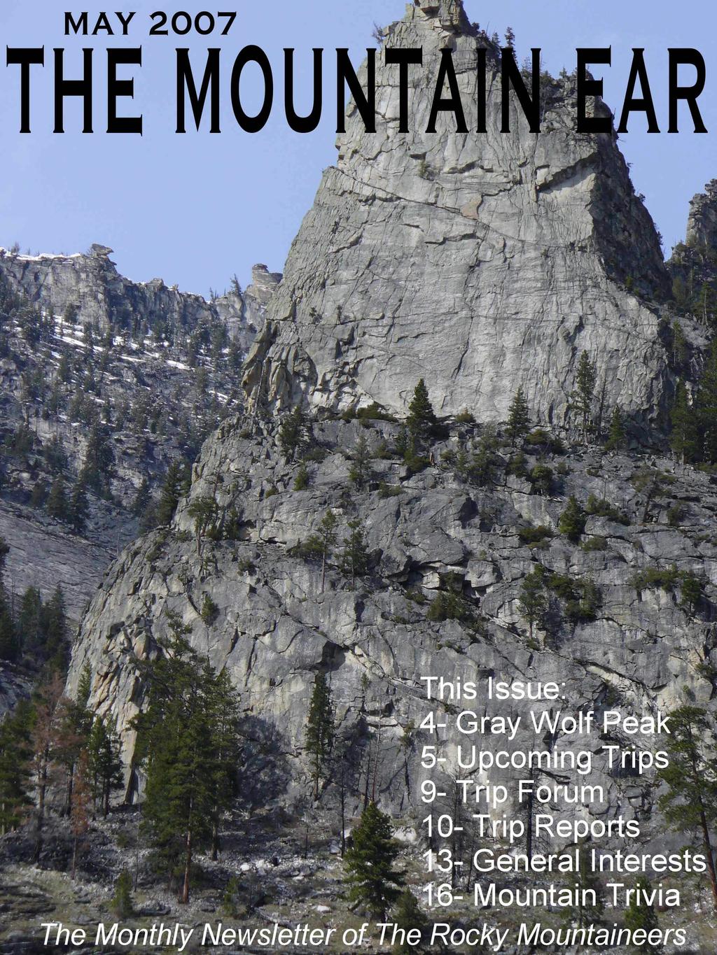
4 Classic Places Gray Wolf Peak This month s Classic Series Trip leads us to the Mission Mountains for a classic spring snow ascent of the south couloir of Gray Wolf Peak. At 9001 Gray Wolf isn t close to the highest in the range, but it may be one of the most interesting and challenging to climb. The following information on this great peak is extracted from Climbers Guide to Montana and used with permission from its author (and TRM member) Pat Caffrey: The west side of Gray Wolf. F. Dean photo South side of Gray Wolf. S. Niday photo. Approaches are unique and exciting. All routes are technical under less than ideal conditions, or when snow is present. Many climbers head into this one early to catch the snow, either in the broad couloir on the south side of the peak, or in the narrow and often icy couloir on the southeast side. Both routes are approached via Riddell Lakes. Start off on an old logging road above Twin Lakes and follow a ridgetop approaching Riddell Lakes from the southwest. The south couloir is right above Riddell Lakes. Reaching the southeast couloir involves striking eastward from between Riddell Lakes, feasting on huckleberries as you cross a low spot in the ridge, and swinging left (northward) into Scenic Lakes Cirque. Both couloirs require a rope and ice axe. The southeast couloir has more tendency to be icy, but if either one has ice you ll also want crampons. The southeast couloir is only about wide, and usually has a moat on each side. It ends in a notch between the main peak and a false summit on the south end of the mountain. Drop out onto the west side of the mountain (you might want to use your rope here) a couple hundred feet, turn right, and find a break up to the summit. If you go up the broad south couloir, cross over the false summit and drop into the notch at the top of the southeast couloir in order to finish out the climb on the west face. If you happen to be in Dry Creek you can do the entire climb up the west face. Climb the talus slope into the main couloir. Near the top of this large gully, traverse left to avoid an overhang, then work up into the high broad basin and on to the summit. If you descend the west face, consider having a rope along for rappelling. This route is an intriguing one to find, and if you do well you ll have no technical difficulties. A more straightforward route is the northeast ridge, another C-rated route which is great if you have a little extra time to get to it. Finally, there is the north ridge, gained by a couloir from No Fish Lake. The couloir ends in an indentation called the Wind Notch, above which technical protection is necessary. 4
5 UPCOMING TRIPS AND ADVENTURES Trip Notes: Please contact the trip leader for more information regarding any listed trips. Mileage listed is round trip mileage. Elevation listed is gain only. For information on Class Rating see below: Class Rating System CLASS 1 HIKING Mostly on trails, but may also include some easy cross country travel. CLASS 2 EASY SCRAMBLING Rugged off trail hiking, no hands required. CLASS 3 SCRAMBLING Use of hand to ascend some sections of rock. Little to no exposure; a fall would not likely cause serious injury. CLASS 4 CLIMBING Easy climbing, great exposure; a fall would quite possibly cause serious injury. Use of a rope and protection at times possible. CLASS 5 TECHNICAL CLIMBING Use of rope, protection and belay are a must. CLASS 6 AID CLIMBING Use of equipment to support your weight as you climb. Saturday, May 5 GREY WOLF PEAK (Mission Mountains) CLASSIC SERIES TRIP Rating: Class 4-5, Mileage: 8 miles, Elevation: ~4200 Description: Will hike up to Riddell Lakes and climb the south snow couloir. This is intended as a snow climb, certain changes to equipment will be dictated by conditions. Participants should have some experience with technical snow and rock climbing, as well as be in reasonably good condition. Special equipment: Tribal recreation permit; ice ax, harness, crampons, helmet; proper clothing. Leader: Forest Dean, or , fdean@midlandimplement.com Sat-Mon, May GUNSIGHT MOUNTAIN (Glacier National Park) Note: This trip co-listed with Glacier Mountaineering Society. Limit 6 participants. Rating: Class 3-4, Mileage: 19 miles, Elevation: 6050 Description: For intermediate climbers/backcountry skiers. On Saturday we will hike in and spend the night at the Sperry campground. Sunday, climb Gunsight (9258 ) crossing the Sperry Glacier & return. Monday, break camp and hike out. This trip may be done as a ski mountaineering trip and the final decision will depend on conditions just prior to the trip. Special Equipment: Climbing harness; winter camping gear Leader: Jim Cossitt - jhckal@yahoo.com Sunday, May 20 th GOAT MOUNTAIN (Bitterroots) Rating: Class 1-2, Mileage: 6.0 miles, Elevation: Description: We will follow a trail to the top of this smaller mountain in the Roaring Lion drainage of the Bitterroots. Goat Mountain is an easternmost point of a long ridge which goes higher and gets more rugged after the trail ends. This point has an elevation of around 6,000', making a steep three mile one way hike with an elevation gain of 1600'-1700'.We will be joined by Mario Locatelli, who lives nearby and who has a lifetime of stories and adventures in the Bitterroots. According to Mario, those in good shape can sprint to the top in half an hour; one and a half hours would be an average time estimate. We will also encourage people who want to keep a slower pace to come along. It is not a very big mountain and there is plenty to see and talk about on the way. Call Steve to find out about meeting times and carpools. Leader: Steve Schombel
6 Sat-Mon, May HUMBUG SPIRES MEMORIAL WEEKEND BASH (Humbug Spires) Description: This trip is intended for all by hopefully appealing to different interests and ability levels. Feel like a simple hike/backpack? Maybe some backcountry fishing? Off trail adventure? Technical rock climbing on some of MT s best rock? Or maybe just a good social time? Well, come along! If you are new to backpacking, this could be a good intro. Plan is to drive down (located about 26 miles south of Butte) on Saturday morning, backpack in to a basecamp (approx. 4 miles), then enjoy your choice of activities until hiking back out on Monday. Kids more than welcome. Some gear assistance can be provided if needed. Leaders: Forest and Angie Dean , , fdean@midlandimplement.com Sat-Sun, June 9-10 EDITH LAKE (Anaconda Pintler Wilderness) Rating: Class 1 (trail), Mileage: 10 miles Description: This will be an overnight backpack to Edith Lake in the Anaconda Pintlers as a shake down trip for the Bob Marshall (see below). This is an easy 5 mile hike to Edith Lake just below Warren Peak. Go in Sat. come out Sun. Those who would like to do it as a day hike also welcome. Leader: Julie Kahl Sunday, June 10 NORTH TRAPPER PEAK (Bitterroots) Rating: Class 4-5, Mileage: 7.5 miles, Elevation Gain: 4400 Description: Will park at the Baker Lake trailhead and use this trail for the approach via Baker, Middle, Gem Lakes, then north over saddle and west to North Trapper. Will climb the southeast couloir and face to the summit (9801 ). Return the same way. Expect a long day and we will get an early start. This will most likely be a mixed alpine climb. Special Equipment: Rope, harness, protection, belay device, helmet. Crampons and ice axe. Leader: Forest Dean H: , C: , fdean@midlandimplement.com Saturday, June 9 WARRIOR MOUNTAIN (Swan Range) Note: This trip co-listed with Glacier Mountaineering Society. Limit 10 participants. Rating: Class 2, Mileage: 10 miles, Elevation: 1500 Description: Trailhead is at Napa Point in the Goat Creek State Forest (elevation 6,423). The trip is an easy trail hike,about 10 miles round trip, along the southern part of the Alpine Trail to Inspiration Pass and on to Warrior Mountain (7903 ). There will be abundant snow on the N & E slopes and an mountain ax is required (the slopes are not steep, but can be very slippery). Dogs are welcome on this non-technical trip. For hikers and intermediate climbers. Special Equipment: Ice ax Leader: Jim Cossitt - jhckal@yahoo.com Fri-Sun, July 6-8 GRAND TETON (Grand Teton National Park) Rating: Class 5,Mileage: 8 miles, Elevation Gain: 7000 Description: Intended route will be the Upper Exum ( ). Group size limit of 4. We will drive down on Friday and possibly hike up to a high camp. We have a reservation for the Lower Saddle for Saturday night. Depending on weather, climb could be done on Saturday or Sunday. Either way we can stay at high camp on Saturday night. Possibly also climb another nearby peak if desired. Special Equipment: Rock climbing gear, possibly crampons, ice ax, backcountry camping gear. Leader: Forest Dean, or , fdean@midlandimplement.com 6
7 Fri-Mon, July PYRAMID PASS to YOUNGS PASS (Bob Marshall Wilderness) Description: The Pyramid Pass to Youngs Pass trip in the Bob Marshall Wilderness is tentatively scheduled for July 13-16th. The 1st day would be trailhead to Pyramid Lake (5 mi); 2nd day Pyramid Lake to Jenny Creek (5 mi); the third day Jenny Creek to trailhead, 7 miles, but the last 4 miles are all down hill. Anyone interested in training hikes over the coming months should contact me also. Leader: Julie Kahl Sun-Thurs, July BLACKFOOT MOUNTAIN and WALTON MOUNTAIN (Glacier National Park) Note: This trip co-listed with Glacier Mountaineering Society. Limit 6 participants. Rating: Class 3-5 Description: For intermediate to advanced climbers. On the 22nd we will hike in and set up base camp near the toe of Jackson Glacier. We will climb on the 23rd and 25th; the 24th will be a rest day at base camp. On the 26th we will break camp and hike out. Both Blackfoot (9597 ) (11 hours, 5,700 vertical) and Walton (8926 ) (14 hours) are long days. For more info, see trip description in 2003 GMS Journal, pp Special Equipment: Glacier gear; backcountry camping gear. Leader: Jim Cossitt - jhckal@yahoo.com Thurs-Sun, July WALLOWA ODYSSEY (Eagle Cap Wilderness NE Oregon) Notes: A more detailed trip description can be found in the March newsletter. Description: July 26 th (Thursday) Leave Missoula 8 a.m. Travel to Joseph, Oregon. Mt Howard Tramway at 1 p.m. (Pacific Time). Take the tram ($15 per person) to the summit 8150 feet for a European style lunch on the patio. Sample the local Terminal Gravity microbrew. Enjoy the view & blubber about climbing. Visualize prospective routes on our destination peaks. Optional short hikes on mountaintop trails. Descend tram by 4 p.m. Hike from nearby West Fork Wallowa River Trailhead (4645 feet) 2.8 miles up the Wallowa Ck Trail. Ice Lake Trail Junction (6040 feet). July 27 th (Friday) Hike 5.1 miles to Ice Lake (7850 feet). Late arrivals, climbers in good shape who only have 3 days for the trip (skipping Day 1), or those who had too much beer on Mt. Howard should be able to catch up from the Trailhead. July 28 th (Saturday) Climb one or both of the two highest peaks in the Eagle Cap Wilderness, Matterhorn (9826 feet) and/or Sacajawea Peak (9838 feet), 6 th & 7 th highest peaks in Oregon. Both are scrambles, but Matterhorn is easier. The ridge connecting the two has some Class 4 outcrops, but it does go. Return to Ice Lake. Warning: Pat will not be packing beer to Ice Lake. July 29 th (Sunday) Descend to Wallowa Cr Trailhead & return to Missoula. Leader: Pat Caffrey Thurs-Sun, August 2-5 BOULDER DASH (Glacier National Park) Notes: Campsite permits have been secured for up to eight persons. Thursday night will be spent at the head of Bowman Lake (beer provided), then we will split between two high-elevation campgrounds. Spots for six persons are still available. 1 st come - 1 st Serve. Send $5.00 to Pat Caffrey, Box 341, Seeley Lake MT to cover share in reservation processing, and state which campgrounds/climbing objectives you prefer. A finalized itinerary & Info Sheet found in the March newsletter will be ed to all participants in July. Description: Excellent opportunity to attempt Kintla Peak using Boulder Pass as a base camp, or to visit other locales in northcentral Glacier National Park without an exhausting approach hike. Thursday August 2 Polebridge Ranger Station in the morning to get permits. Drive to foot of Bowman Lake and motorboat 7 miles to our campsite at the head of the lake (4030 ft). 7
8 Friday August 3 Hike to campsites at Hole In The Wall (6400 ft) 8.3 miles and Boulder Pass (7280 ft) 12.3 miles. Saturday August 4 Climbing day! Stay at campsites at Boulder Pass or Brown Pass (6255 ft 6.7 miles from Bowman Lake). Sunday August 5 Return hike to Bowman Lake. Ferry to foot of lake. Return home. Leader: Pat Caffrey , pcaffrey@plumcreek.com. Sun, Sept 2 HEAVENS PEAK (Glacier National Park) Note: This trip co-listed with Glacier Mountaineering Society. Limit 10 participants. Rating: Class 3-4, Mileage: 6 miles, Elevation: 5000 Description: For intermediate climbers. A long day with over 5000 feet in elevation gain. We will cross McDonald Creek, ascend the Glacier Wall, traverse across the base of the mountain and ascend from there. Summit is Leader: Jim Cossitt - jhckal@yahoo.com 2007 CLASSIC SERIES Details about these trips will be listed in the newsletter as the times get closer. May trip is listed above. Month Destination Area Type Leader May Grey Wolf Peak Missions Snow Climb Forest Dean Jun Burnt Fork Pinnacle Reservation Divide Hike Alden Wright Jul Lolo Peak Bitterroots Hike/Scramble Steve Schombel Aug 3 rd Glacier Classic Logan Pass Various Steve Niday Sep Warren Peak Pintlers Scramble Jim Wilson Oct McDonald Peak Missions Climb Forest Dean Nov Chief Joseph Pass Bitterroots Ski Steve Schombel Dec Sweeney Peak Bitterroots Hike/Ski/Snowshoe Forest Dean Note: Sudden urge to go do something this weekend and want some fellow club members to do it with? Anyone wishing to submit last minute trips can do so by either calling or ing the editor. A mass can then be sent out to the membership. Call , or fdean@midlandimplement.com 8
9 Trip Forum Thinking about a trip this coming summer/fall or even next winter, but no definite dates yet? Looking for partners to plan some big adventure? Well here is the place to do it! The Trip Forum section serves as a bulletin board for those grand plans circling around in your head. Once you firm up dates and details, the trip can then be moved into the Upcoming Trips and Adventures section, if you so choose. Feel free to submit your ideas! The following is a sampling: Pilot Knob This will be a hike/scramble to this rocky point in the Lolo Pass area of the Bitterroots. More information will follow in next newsletter. Leader: Julie Kahl ( ) Missoula Summit Day The Bitterroot-Mission Group of the Sierra Club is looking for outdoor groups to join in Missoula Summit Day set for Saturday, August 4th. Groups who practice quiet use recreation can lead a hike to their "adopted" local peak and give the public an opportunity to experience an outing to one of our local high places. In the process our community can become more familiar with the groups who routinely explore, enjoy and protect our wildlands. Thus far the Sierra Club has "adopted" Lolo Peak, the UM Outdoor Club plans to do Sleeping Woman Peak and the Back Country Horsemen are considering a ride up Mount Jumbo. Mary Dalton has expressed interest in leading a Rocky Mountaineers trip to Stuart Peak and would like for anyone interested in co-leading to call her at Along with the trip descriptions each group will have the opportunity to attach a few sentences about their mission statement, activities, meetings and contact information. The Sierra Club will handle the local publicity, flyering and overall coordination for this event. For more information contact the Bitterroot-Mission Group's Outings Chairperson John Wolverton at or yodelingdog@hotmail.com 3 rd Annual Glacier Classic Dates: August Location: Glacier National Park Camp: Fish Creek Campground on Lake McDonald We are still putting the details together for this event. A schedule of events with hikes and climbs will be available in the June newsletter. We are currently working on reserving some campsites at Fish Creek Campground. If you would like to attend, please let us know as it will affect how many sites we reserve. All attendees will split the costs of the campsites, so it should be pretty minimal. We hope to have three hikes, climbs, or other activities to list for both Saturday and Sunday. If you are interested in leading a hike or climb, just let us know. The plan will be to arrive up at the campground any time on Friday, set up camp, eat, drink, and be merry. Then on Saturday you can partake in one of the trips. Back to camp for more revelry on Saturday night. On Sunday partake in another trip (if you want), then drive home (if you want). Here is what we have so far. Saturday 1 Reynolds Mountain 2 Huckleberry Mountain Lookout 3 Sunday 1 Piegan Mountain, Pollock Mountain and Bishops Cap Traverse 2 3-9

. We parked at the second crossing of Troy Creek (5500 ) and headed up with our skies on our backs.")

10 TRIP REPORTS April 14 Trapper Peak (Bitterroots) As the April 2007 installment of the Rocky Mountaineers Classic Series Trips, Alden Wright led a ski trip up the normal route of Trapper Peak. We met at 6:35am in the K-mart parking lot and headed down the root. Ron Pierson, Alden and I arrived at the turn off for the Trapper Peak trailhead and found that we were following Brett Doucett up the mountain on our way to the trailhead (a bit of foreshadowing for the coming climb). We parked at the second crossing of Troy Creek (5500 ) and headed up with our skies on our backs. It had been cold enough the night before to allow us to hike on top of the snow to approximately 8000 before we donned our skis. At one point we were accompanied by some bobcat tracks paralleling our path. We made the summit by 2pm and were joined by two others (that, as it turns out, participated in Alden s trip last year!) The visibility was excellent and we marveled at the array of snow capped mountains that Trapper offers. As the wind intensified and the clouds gathered, our bodies began to chill and we retreated from the summit one by one. It had been a brilliantly sunny day and the snow had softened considerably. The downhill offered mostly wet, heavy snow that was difficult for me to navigate (Alden seemed to do fine)! There was one really good stretch of skiing roughly between 9600 and On our way down we met three other skiers who were headed up for a short run. Back at the truck at about 6pm, hungry and tired, we thanked Alden for picking a perfect weather window for leading a great trip. Joshua Phillips (trip photos by Joshua as well) Trip leader Alden Wright on the descent. April 21- Columbia Mountain (Swan Range) On a sunny & brisk late April Saturday morning, 7 of us kicked off the 2007 GMS season on Columbia Mountain. After the usual long traverse around the base of Columbia, we started the climb. At the 5,600 foot level (where the trail switchback meets the big gully on the right of the trail) we began to encounter intermittent snow (it had been storming in the Flathead valley for the 2 days preceding our trip). From about 6,000 feet to the summit (7,234) it was a tough snow climb, with a breakable crust and about inches of unconsolidated snow underneath. Many calories were expended by the group during the final 1,200 feet to the summit. Alden, Brett and Ron on the summit. 10 Climbing towards the summit. Jim Cossitt photo. Trip stats according to my Suunto watch: 5, 089 feet up, 5,082 feet down and 7:34 elapsed time. We started about 0830, summitted about 1230-


11 1300, departed the summit around 1330 and got back to the trailhead around As we were starting our hike, we saw Linda Soper at the trailhead who advised us she had started at 0415 or so and just returned to her car. Sounds like a good cure for insomnia..... Our group included Dennis & Shirley Twohig, Frank Weslowski, Nancy Riva, Keith Kratzer, Ned Sohl, Jim Cossitt and the star of the trip: Vidar. Vidar traveled at least twice as far and twice as much vertical as the rest of us! Woof! Jim Cossitt Summit photo! Jim Cossitt photo. April 21 - Mt Sentinel TerraCaching Hike Patricia and Lorraine joined Jon on the Intro to TerraCaching hike. After a quick trip back to the house for warmer clothes by a hiker to remain nameless, and a (maybe too) brief tutorial on how to use a GPS, we got started at 10:30 and headed up the Kim Williams trail toward the junction with Hellgate 11, then on up the mountain. We reached the first cache part way up the mountain at about noon, and the ladies looked around for the cache for a little while until Jon was able to confirm the cache wasn't where it was last time he was here. Wallowing in the despair of starting the trip with a no-find, we ate some lunch. Lorraine had to get back home claiming better things to do, so she headed back and Patricia and Jon pressed on. 11 Our next cache was on the top of University Mountain, but on the way up we happened to run into the hider of the previous missing cache on his way back down the mountain, so we chatted for a while and Jon reported the missing cache. There were a couple inches of show on top this morning, which can making finding a small container a little more challenging. Patricia looked high and low, but not having been to this cache in over 2 years, Jon wasn't sure himself where it was. So, at 2:30pm, we were 0 for 2. Back down we went toward the summit of Mt. Sentinel, where an easy find was to be had. This was a virtual cache where the finder was required to count the number of holes, bolts, and washers in an iron post apparently placed just off the summit ages ago to keep the mountain from walking away. Patricia spotted the requisite item from 50 feet away. From there, it was a nice walk south along the ridge to our final cache. After about 3 minutes of checking likely looking spots, Patricia found an ammo can with a log book, pencil, and a handful of plastic dinosaurs. She signed the log, noted the confirmation code she needed to submit a find to the website, and off we where back down to the trail head. We reached the parking lot again at 5:15pm. Jon managed to shoot some video of the trip, and posted a short movie Trip Report to... Jon Garvin Patricia and Jon on University Mtn. J. Garvin photo.


12 April 22 Kootenai Creek (Bitterroots) Eileen & Fred Schwanemann, Steve Schombel, Julie & Dave Kahl, and Barbara Ross took Kootenai Creek trail to the Wilderness Boundary and back. We had many Earth Day surprises. Early on we spotted a very tiny Winter Wren which was perched close to the ground. After about an hour of hiking, we started seeing many flowers which included Yellow Bells, Shooting Stars, Trillium, Glacier Lilies,and Indian Paintbrush. There were many more Trillium than the few raindrops at the hike's start. The sun came out at lunch and on the way back. The sun brought out the butterflies. We saw at least five species including the Morning Cloak, the MT butterfly. Fred Schwanemann us, hit the brakes hard, and abruptly reversed course. Does that count as a wolf sighting? Under better conditions, this looks like a good early season climb, not too hard, and not too easy. Steve Niday April Edward Mtn (Glacier N.P.) First there were five, then there were two. Forest and I started up the Sperry Chalet trail in the early afternoon and put our skis on at around two miles and We camped in the lower Glacier Basin at around At 6:20 AM on Saturday, we were moving toward our objective. Less than a mile later, and a mere 700 higher, we called it quits. Forest s energy was not enough to offset the reality that the snow conditions would not allow a safe summit bid. The weather system that deposited snow on the foothills around Missoula recently deposited over a foot of new snow in this area of Glacier Park. The new snow slid easily on the older snow, we witnessed several big spontaneous slides late Friday afternoon. When it got steep and we removed our skis, we sunk. Progress would have been too slow to summit and return while the snow was still stable. The options were to climb on and spend the night high to allow the snow to solidify for a safe descent on Sunday morning, or turn around and head home. We opted for the latter. We did visit Sperry Chalet and could have easily skied onto the roof, there s still at least 7 feet of snow. In the upper Glacier Basin, where Sperry Chalet is located, we saw one set of elk tracks and one set of wolf tracks, one following the other. Lower down I saw a flash of fur and when we got to where I saw it, there was a very fresh wolf track deeply embedded in the mud in the trail. Following the trajectory of the track there was a large expanse of snow and no tracks. We surmised the wolf saw 12 Forest at our high point (6700 ). S. Niday photo. Edwards Mountain. S. Niday photo.
13 GENERAL INTERESTS LOLO PEAK FILM Monday, May 7-7:30 PM, Missoula Children's Theater One of Missoula's long time independent film makers has completed his latest project. It is titled "Oh No Lolo" by Gene Bernofsky. It runs for 43 minutes and advocates the protection of Lolo Peak. A $6.00 donation is requested. ADVENTURES IN THE BITTERROOTS In case you missed it, Mario Locatelli is giving a second showing of his slides about his "Adventures in the Bitterroots." Mario has spent 30 some years hiking every peak, ridge and drainage in the Bitterroots, and has many spectacular slides. This time his show will be followed by a shorter show about winter skiing on Lolo Peak by Jeremy Lurgio. Some of you may remember a great skiing show Jeremy did at one of the Rocky Mountaineers meetings a few years ago. This will be followed by a presentation on the recent activities of the Bitterroot Resort, and information on why many people would like to keep Lolo Peak and Carleton Ridge wild and undeveloped. This show will be at the Lolo Community Center on Thursday, May 17th, at 7:00 PM, and is free. The Lolo Community Center is on Highway 93 just south of the junction with Highway 12, and is on the right (west) when you're headed south. PENGELLY DOUBLE DIP Saturday, June 16, :00 AM This is year FOUR for the Double Dip, an epic trail run to benefit Youth Homes, a non-profit that is committed to caring for children in need. Course options: One Dip: A 4.6 mile circle up the M trail, along the fire road and returning to the Univeristy of Montana oval. Two Dips: The 12.5 mile challenging mountain run. This course winds its way up Mount Sentinel peaking at the University Beacon. It consists of steep terrain and scenic views atop Missoula's most popular mountain! Create a relay team or be a daring individual. Monte Mile Fun Run: The course uses the oval and will not run along any streets. All kids received a participant ribbon and fun run number. Strollers welcome! NEW THIS YEAR! A 5K flat ground run/walk on the Kim Williams Trail. Enjoy the sights and sounds of the Clark Fork River as this course starts and finishes at the oval on the UM campus! ml Note: This event is named in honor of the late Dave Pengelly, TRM Member, one time President, and friend to many. 13
14 APRIL BUSINESS MEETING Minutes Called to Order 6:08 2. Attendance: Steve Niday, Julie Kahl, Dave Wright, Alden Wright, Steve Schombel, Forest Dean, Lorraine Riedl, Jim Wilson 3. Minutes: Approved with no changes 4. Correspondence: Steve N. heard from Becky Richards about the club helping with a remembrance for her son, Ben Richards who died recently in the Gallatin N.F. She is thinking about a speaker next year from the Gallatin on avalanche awareness, combined with youth outreach and maybe a training course. Forest will contact Becky to see if she would suggest someone, and we could provide the time and place and publicity. No other correspondence. 5. Treasurers report: $ balanced on Club Business A. Slate of officers: Dave Wright was talked into running for secretary instead of Lorraine. Forest brought up the issue that this will be his 3 rd year as V.P., which violates the bylaws. Steve N. will ask the members later if there are any objections to making an exemption. (None were raised). Other nominees remain: Steve Niday as President and Julia Kahl as treasurer. (None from the floor later.) B. Other clubs: We did not feel we would like to have joint meetings with the Grotto, but maybe a few times a year, and alternate speakers. We should try to limit presentations to 1 hour, and Steve S. will inform upcoming speakers. There are some problems with GMS having a member s only policy and having some of their trips listed as joint trips. Jim Cossit is going to ask the GMS board to allow us to go on their trips. Forest wants this cleared up before listing more trips, and more info on their sign up policy. No problems seen with Sierra Club and summitpost is just a few employees who may go to Glacier, not a club to club connection. C. Logo contest: Steve N. went to a shirt shop to see which designs would work well. They happen to be the ones we favor. He also wants us to think about approving money up front from treasury to start merchandizing. He will send an with the three favored design and a description and number for a vote. We will take the final vote at the May meeting. D. Trips: Glacier Classic- the reservation system was down but Steve N. will try again for a group site or 3 adjoining sites at Fish Creek. Cabin Work Day- the date, Sept. 29 th, was picked last month, and it was suggested and approved that we have the picnic at the overlook. Lolo Peak- Dave may not be able to lead it, but Alden is interested. He would like to do the Westside route. E. Achievement Awards: Not enough time for much discussion, but Steve N. is thinking of a list of categories to send to members for comments. F. Other business: Julie showed a calendar she made of Ireland photos and would like to make one for us for merchandizing. Other members will be encouraged to submit photos. 7. Meeting adjourned at 6:58 14

15 Sunset on Mount Rainier ( Left to Right: Sunset Amphitheater, Tahoma Glacier, Point Success) Deep Thinking.. Photo courtesy of Kevin Ball "In light of the rising frequency of human/grizzly bear conflicts, the Department of Fish and Game is advising hikers, hunters, and fishermen to take extra precautions and keep alert for bears while in the field. We advise that outdoors men wear noisy little bells on their clothing so as not to startle bears that aren't expecting them. We also advise outdoors men to carry pepper spray with them in case of an encounter with a bear. It is also a good idea to watch out for fresh signs of bear activity. Outdoors men should recognize the difference between black bear and grizzly bear droppings. Black bear droppings are smaller and contain lots of berries and squirrel fur. Grizzly bear droppings have little bells in them and smell like pepper." Grizzly bear notice. "Solo climber: One climber falling. Alpine style: Lots of climbers falling, tied together. Bouldering: One climber falling and missing a thick mat. Trad: One climber falling on another climber." "Was that 'on belay' or 'off belay'?" Common climbing last words. 15
16 Mountain Trivia Challenge!! This Month: Where (in the Bitterroot Mountains) Am I? Last month I either made this too challenging or nobody cared! So to increase interest I figured I better give away a prize. Anyone answering the following questions correctly will be entered into a drawing. The winner will receive their choice of either (2) six packs of Big Sky beer or (2) bottles of wine. Deadline for ing or calling me with your answers will be May 25 th. Good luck! All answers are places that can be found in the Bitterroot Mountain. (Note: I said the Bitterroot Mountains- not the entire Bitterroot Range) 1 The lake I am camped at is a result of a massive landslide let loose from the 4 th highest peak in the Bitterroot Mountains. The slide created a rock dam which in turn created the lake. Where am I? 2 The lake I am now camped at is the first one I could have possible camped at after hiking up this drainage that has several prominent spires and buttresses with Native-American names. Where am I? 3 The view from this pit toilet just feet from the summit of this foot peak is incredible! Surely having a chance to sit on such a throne must be the reason why this peak is one of the more popular climbs in these mountains. Where am I? 4 I am camped at a lake named after a species of tree. To my north/northwest lies a peak without an official USGS name, but nevertheless one of the top 10 highest in the Bitterroot Mountains. Another top 10 highpoint lies to my south/southeast (this one is named). Any idea what lake I am at? 5 There must be some way out of here, said the joker to the thief. I sing this opening line from a song written by Bob Dylan and famously covered by Jimi Hendrix. Why? Because the name of the peak almost due west of the foot peak where I now sit is part of the title of that song. Where am I? Last Month s Answers: I am looking to the north and see some lakes below me. My altimeter says 7960 feet as I rest on this summit. A SNOTEL site is nearby. Thinking about running the 10 miles back to the trailhead. Where am I? Stuart Peak (Rattlesnake) Elsewhere in this range a Little Mountain is higher than Mountain ( is the same name). As I sit here on this summit I ponder this oddity; I also enjoy the views to the east/southeast of this ranges highest point. Maybe it s the 10,000 + air! Where am I? Warren Peak (Pintlers) If my feet were 34 above where they are right now I would be at the highest point of the state I am currently in. But my feet are here. Do you know where? Grand Teton (Grand Teton National Park) I know where I am! I am enjoying some nice cold samplers at the Big Sky Brewery tasting room! I love free! Worked up this thirst when I followed some (unnamed) trip leader up a mountain that we could have just driven to the top of. As I step out of the tap-room, I look south and see where I was. Where was that? Blue Mountain (Blue Mtn Rec Area) As I sit here on this summit I think about the book I just read about a group of five climbers who died on this same mountain. Where am I? Mt. Cleveland (Glacier National Park) 16
17 This month s cover photo: Shoshone Spire in Blodgett Canyon- Bitterroot National Forest. Photo by Forest Dean. THE ROCKY MOUNTAINEERS MEMBERSHIP APPICATION Annual Membership Fee: $20.00 for paper newsletter $10.00 for electronic newsletter Note: Membership includes all members of a family or household. Make checks payable to The Rocky Mountaineers and send to: The Rocky Mountaineers, PO Box 4262, Missoula, MT Name: Additional Family Members Names: Address: Home Phone: Cell Phone (optional): Additional (optional): Joining or maintaining your Rocky Mountaineers membership has never been easier! PayPal is now available on the Rocky Mountaineers website. Click on the membership link on the main page. 17
18 THE ROCKY MOUNTAINEERS PO Box 4262 Missoula, MT
March, Monthly Newsletter of The Rocky Mountaineers
 March, 2017 Monthly Newsletter of The Rocky Mountaineers Cover Photo: Florence Crags from Little St. Joe Mt. Photo: Matt Roscoe Climb, Hike, Ski, Bike, Paddle. Dedicated to the Enjoyment, and Promotion
The Mountain Ear. April 2018
 The Mountain Ear April 2018 President s Message Greetings! My standard method of writing these monthly newsletters is to compose all the information that follows, then prepare the President s Message last.
Grizzly Peak A - East Ridge July 15, 2012
 Grizzly Peak A - East Ridge July 15, 2012 Difficulty: Difficult Class 2/Class 3 Upper Elevation: 13,995 feet Trailhead Elevation: 11,360 feet Elevation Gain: 3,000 feet Round-trip Length: 6.0 miles Trailhead:
GOLDEN EARS PROVINCIAL PARK
 GOLDEN EARS PROVINCIAL PARK Trail Information as of October 10 th 2015 Do not underestimate the mountainous wilderness of Golden Ears Provincial Park. The combination of rugged terrain and rapidly changing
Rogue Gorge (Mt. Stella) Roadless Area-- T30S R3E (primarily in portions of Sections 23, 26, 33, 34 & 35)
 Roadless Area-- T30S R3E (primarily in portions of Sections 23, 26, 33, 34 & 35)") Rogue Gorge (Mt. Stella) Roadless Area-- T30S R3E (primarily in portions of Sections 23, 26, 33, 34 & 35) Rogue River-Siskiyou National Forest--High Cascades Ranger District Upper, higher elevation trail
Rogue Gorge (Mt. Stella) Roadless Area-- T30S R3E (primarily in portions of Sections 23, 26, 33, 34 & 35) Rogue River-Siskiyou National Forest--High Cascades Ranger District Upper, higher elevation trail
Lava Mountain Trail Distance: Elevation Range: Trail Type: Difficulty: Season: Driving Distance: Driving Time: USGS Maps: Pros Cons
 Lava Mountain Trail Distance: 13.4 miles (including the side trip to North Star Lake) Elevation Range: 5900'-8330' Trail Type: singletrack Difficulty: moderate Season: late June-October Driving Distance:
Route #2) Mt. Massive - Southwest Slopes
 Mt. Massive - Southwest Slopes") Route #2) Mt. Massive - Southwest Slopes Difficulty: Class 2 Ski: Advanced, D6 / R2 / III Exposure: Summit Elevation: Trailhead Elevation: Elevation Gain: Round-trip Length: Trailhead: County Sheriff:
Route #2) Mt. Massive - Southwest Slopes Difficulty: Class 2 Ski: Advanced, D6 / R2 / III Exposure: Summit Elevation: Trailhead Elevation: Elevation Gain: Round-trip Length: Trailhead: County Sheriff:
Trail Report for KOKANEE GLACIER PROVINCIAL PARK and other Kootenay Lake Area parks (including west side of Purcell Wilderness Conservancy)
") Updated: October 23, 2017 Please call 250-354-6333 if you have new trail conditions to report. PARK AREA ROADS TRAILS ADDITIONAL INFORMATION Kokanee Creek SPECIAL NOTICE: Trail from Gibson Lake to drainage
Updated: October 23, 2017 Please call 250-354-6333 if you have new trail conditions to report. PARK AREA ROADS TRAILS ADDITIONAL INFORMATION Kokanee Creek SPECIAL NOTICE: Trail from Gibson Lake to drainage
TUPPER DESIGNATED ACCESS ROUTE
 TUPPER DESIGNATED ACCESS ROUTE 1 FOR ACCESS/EGRESS TO CONNAUGHT, LOOKOUT, STONE ARCH, PORTAL PATHS AND TUPPER TRAVERSE EGRESS Length: 2.6km Vertical Gain: +162m / -83m (Values are for access. For egress,
Mt. Thielsen Trip Report: April 29, 2012
 Mt. Thielsen Trip Report: April 29, 2012 Outing Organizer: Geoff Hance, with Brent McGregor Elevation Gain: 3,800 feet, over warming snow, with an exposed summit block Distance: About 9 miles round trip
Three Sisters Wilderness Oct. 2009
 Three Sisters Wilderness Oct. 2009 I was in Bend, OR and had the whole day to travel back to Boise so I decided to take a hike to the popular Green Lakes and summit the South Sister in Three Sisters Wilderness.
Route #1) Mt. of the Holy Cross - North Ridge
 Mt. of the Holy Cross - North Ridge") Climbing 14ers can be very dangerous, please read the Mountaineering Safety Page and make sure you have a map+compass and can use them effectively, without the help of electronic devices. Route #1) Mt.
Climbing 14ers can be very dangerous, please read the Mountaineering Safety Page and make sure you have a map+compass and can use them effectively, without the help of electronic devices. Route #1) Mt.
Glacier National Park, MT
 Glacier National Park, MT July 28 Aug. 1, 2010 We decided to go to Glacier National Park for our family vacation this year. We had a great time seeing beautiful scenery and a variety of wildlife which
Mount Daly a Most Prominent Peak via South Ridge
 Mount Daly a Most Prominent Peak via South Ridge Difficulty: Class 3 Exposure: Exposed in places along the ridge Summit Elevation: 13,305 Elevation Gain: 4100 from trailhead; 1800 from Capitol Lake camp
CIEC 9 PEAKS AWARD SUPPLEMENT POSSIBLE ROUTES FOR THE 9 PEAKS AWARD TRIP
 CIEC 9 PEAKS AWARD SUPPLEMENT POSSIBLE ROUTES FOR THE 9 PEAKS AWARD TRIP As you plan your trip, be aware of 3 regulations in this wilderness: 1. Camp only in designated campsites. 2. No campfires allowed.
Cycle OrEgon Hells Canyon/wallowas
 Cycle OrEgon 215 Hells Canyon/wallowas Live to Ride. Ride to Give. We may be born to be wild, but we live to do good things. From mountain bike trails near Baker City to a renovated city park in Cambridge,
Route Combo) Mt. Bierstadt - Bierstadt, Sawtooth, Evans
 Mt. Bierstadt - Bierstadt, Sawtooth, Evans") Climbing 14ers can be very dangerous, please read the Mountaineering Safety Page and make sure you have a map+compass and can use them effectively, without the help of electronic devices. Route Combo)
Climbing 14ers can be very dangerous, please read the Mountaineering Safety Page and make sure you have a map+compass and can use them effectively, without the help of electronic devices. Route Combo)
Glacier National Park
 Glacier National Park West Glacier, MO Page 1 Page 3-6 Report Rough Draft Glacier National Park Glacier National Park is located in the northwest corner of Montana and extends into Canada. It is located
Trip Report: Backpack to East Boulder Lake in California Trinity Alps, July 7-9, 2016
 Trip Report: Backpack to East Boulder Lake in California Trinity Alps, July 7-9, 2016 Trekkers: Richard Hales, Aleece Townsend, Carol Mockridge, Rosalie Rybka, Elisabeth Zinser Day 1: Richard and Aleece
Skiing and Snowshoes on Un-groomed Fernan Saddle Terrain
 Skiing and Snowshoes on Un-groomed Fernan Saddle Terrain Three ski or snowshoe routes are available from the Fernan Saddle Parking Lot which either do not cover routes ordinarily groomed for snow machine
PERUVIAN ANDES ADVENTURES. ARTESONRAJU CLIMB 6025m (19767 ft) Grade: D+ to TD/ Technical. Routes: The two routes to climb Artesonraju are;
 Grade: D+ to TD/ Technical. Routes: The two routes to climb Artesonraju are;") PERUVIAN ANDES ADVENTURES ARTESONRAJU CLIMB 6025m (19767 ft) Grade: D+ to TD/ Technical Routes: The two routes to climb Artesonraju are; *Via the Paron Valley South East Ridge 5 days (option for 6 with
PERUVIAN ANDES ADVENTURES ARTESONRAJU CLIMB 6025m (19767 ft) Grade: D+ to TD/ Technical Routes: The two routes to climb Artesonraju are; *Via the Paron Valley South East Ridge 5 days (option for 6 with
SYNOPSIS WEATHER AND SNOWPACK
 Peak 6996 Avalanche Fatality Incident Report Glacier National Park, MT Date of Avalanche: 31 March 2010 Date of Investigation: 2 April 2010 Investigation Team: Erich Peitzsch (USGS), Ted Steiner (Chugach
Mt. Rainier Three-Day Muir Climb
 Mt. Rainier Three-Day Muir Climb Details below provided by AAI Elevation: 14,411 feet Guide Service: Alpine Ascents International (AAI) Fundraising minimum: $5,000.00 USD Muir Three-Day Overview Our three-day
Itinerary Overview. Sawatch Range Mountaineering Ages days
 Itinerary Overview Sawatch Range Mountaineering Ages 14-16 22 days Course Description Welcome, you re in for an experience of a lifetime! Imagine hiking through rolling forests, sharing alpine meadows
Friday October 3. Lower Javelina Trail - Level D. about 3 miles, less than 500. Hike Contact: Joel Tormoen
 Friday October 3 Lower Javelina Trail - Level D. about 3 miles, less than 500 Hike Contact: Joel Tormoen joeltormoen@gmail.com Depart WB trailhead 8:00 am - return before 11:00 am This quite easy hike
30 years TRAIL TAILS JULY MAY OFFICERS
 EAST SLOPE BACK COUNTRY HORSEMEN 30 years TRAIL TAILS JULY MAY 2013 2010 OFFICERS President: Bob Hermance Vice President: Dick Kinyon Secretary/ Treasurer: LeAnn Hermance State Directors: Fred Fitzpatrick
The Wilderness Voice
 The Wilderness Voice Newsletter of the Madison Gallatin Chapter Vol 6, No. 3, - Winter 2018 Forest Planning Update Your Voice Is Needed by Sally Cathey, SW Montana field director Soon we will see our first
Non-motorized Trail Plan & Proposal. August 8, 2014
 Town of Star Valley Ranch, Wyoming and the Star Valley Ranch Association in partnership with the USDA Forest Service, Bridger-Teton National Forest, Greys River Ranger District Non-motorized Trail Plan
TREK THE ROCKIES ABOUT THE CHALLENGE TREK THE ROCKIES FOR HIGHLAND HOSPICE CANADA TREK DEMANDING
 TREK THE ROCKIES CANADA TREK DEMANDING ABOUT THE CHALLENGE The Canadian Rockies are justifiably world-famous for their magnificent scenery: the combination of impressive, jagged mountains, bright turquoise
Trail Beginning Elevation: 7553 ft The Poison Creek Trailhead is located at the end of National Forest Road 646E (NF-646E).
.") West Mountain Trails Poison Creek Trail #134 Length: 2.9 miles (4.7 km) Difficulty Horseback: A good trail for the first time west mountain rider, some steep sections Hiking: Most Difficult USGS Maps:
West Mountain Trails Poison Creek Trail #134 Length: 2.9 miles (4.7 km) Difficulty Horseback: A good trail for the first time west mountain rider, some steep sections Hiking: Most Difficult USGS Maps:
Location: Height: Access: Distance: Elevation: Season: Difficulty: Lat/Long: Directions:
 Upper Eagle Falls Upper Eagle Falls (~20 ft.) is a short hike up from the roadside at the Eagle Falls picnic area. It is very difficult to get a parking spot here during the day, so it is recommended to
playwinterpark.com Off The Beaten Path Hikes Hiking Recommendations for the Adventurous Hiker
 playwinterpark.com Off The Beaten Path Hikes Hiking Recommendations for the Adventurous Hiker Hike: Devil s Thumb (difficult) Length: 3.93 miles one-way Elevation: Trailhead 9609 Destination 12,236 Trailhead
Dnigi Hut. Dnigi is Dnaina for Moose. Location:
 Dnigi Hut in places. Stay on the main thoroughfare. Continue along the ridge top, going east to a pass above Knob Creek. Just beyond here look for a left turn which descends north-northwest (61,45.578,-148,52.414,2081
Itinerary Overview. Maroon Bells Mountaineering 22-days. Course Description
 Itinerary Overview Maroon Bells Mountaineering 22-days Course Description Welcome, you re in for an experience of a lifetime! Imagine hiking through rolling forests, sharing alpine meadows with mountain
18 day itinerary: ACONCAGUA Normal Route 15 day trek. T r i p I t i n e r a r y
 T r i p I t i n e r a r y HIGHLIGHTS Summit the highest mountain in South America, and the second highest of the Seven Summits Breath-taking views of the Andes Three days set aside for the summit attempt
Mountain Footsteps. Photo: Ric Carless
 ho: Ric Carless Road Directions Middle White River FS Roads Deep Lake and Driftwood Lake see page 101, Connor Lakes along Maiyuk Creek see page 105, and for access Top of the World rovincial ark see page
Quandary Peak East Ridge
 Quandary Peak East Ridge Difficulty: Class 1 / 2 June 28,2013 Exposure: Summit Elev.: 14,265 feet Trailhead Elev.: 10,850 feet Elevation Gain: 3,450 feet Roundtrip: 6.75 miles Hikers: Shan Stuart, Rick
Explore Montana s Glacier National Park!
 Explore Montana s Glacier National Park! Sat-Sat, July 13-20 or July 20-27, 2019 1 P a g e Trailbound Trips Explore. Dream. Discover. Discover: * Stunning hikes * Glacier-studded mountain peaks * Wildlife
Adventures in the Rockies. 6 Days
 Adventures in the Rockies 6 Days Adventures in the Rockies On this action-filled adventure, experience two different sides to the Rockies on the western side, discover hidden gems that few visitors get
Bradshaw Trails Series
 Bradshaw Trails Series Curtis James Troop 7014 Curtis.James@erau.edu My Motto: Never get lost! Hiking Rules Bradshaw Hiking Patch Series Hiking Tools Hiking Rules Hiking Merit Badge* Take five 10-mile
Draft II - Trip Report by Kurt Wibbenmeyer
 Draft II - Trip Report by Kurt Wibbenmeyer COLORADO MOUNTAIN CLUB FAIRWEATHER MOUNTAIN EXPEDITION 2010 TEAM Rich McAdams Leader Mike Butyn Wayne Herrick Gerry Roach Bill Blazek Dave Covill Jim Rickard
Avalanches and the Mount Whitney Basin
 Avalanches and the Mount Whitney Basin 10 April 2006 by Bob Rockwell Prelude Avalanches are a fact of life in high mountains in winter, and we take courses to find out about them. We learn how to assess
Kitimat. Pacific Inland Coast. Hiking Guide Kitimat, British Columbia, Canada
 Kitimat Pacific Inland Coast Hiking Guide Kitimat, British Columbia, Canada 2010-2011 Sites and Trails Emergency Call 911 Police - Fire - Medical 2 Welcome to Kitimat This information was produced to assist
Camp Geronimo Rainbow Trails
 Camp Geronimo Rainbow Trails With over 5,000 acres of surrounding national forest, the possibilities of getting out and seeing the wilderness are almost limitless. Camp Geronimo offers some of the greatest
OMH Trail Data / History
 Lake Sylvia Loop Ouachita National Forest (AR) This is a five-mile loop with several variations for Saturday hikes. The basic loop starts at Lake Sylvia campground and goes south to meet the Ouachita Trail
Get Out And Hike! From Bruce Rieman, scientist and retired fish guy:
 Get Out And Hike! Living between the Swans and Missions and not hiking is like living in Anaheim, California and not visiting Disneyland. To help others and myself enjoy our unique surroundings, I asked
Excelsior Pass Avalanche Accident January 1, 2008
 Excelsior Pass Avalanche Accident January 1, 2008 Accident Summary Time: 1 January 2008, approximately 13:00 hrs Location: Near Excelsior Pass to east of Church Mt, Northern Washington Cascades WA Activity:
County Line trail - Miller Peak to Little Navaho
 County Line trail - Miller Peak to Little Navaho 7-17-2008 This hike features a portion of the County Line trail in the Teanaway that receives extremely little use despite offering a spectacular ridge-run
Mt. Eolus and North Eolus
 Mt. Eolus and North Eolus Difficulty: Class 3 Exposure: Summit Elev.: Mt. Eolus: 14,083 feet N. Eolus: 14,039 feet Camp Elev.: 11,100 feet Elevation Gain: 3,200' starting at Chicago Basin 6,300' starting
ABOUT THE PARKS NANTAHALA NATIONAL FOREST MOUNTAINS NATIONAL PARK CHEROKEE NATIONAL FOREST PISGAH NATIONAL FOREST GREAT SMOKY HIKING TRAILS
 ABOUT THE PARKS GREAT SMOKY MOUNTAINS NATIONAL PARK NANTAHALA NATIONAL FOREST CHEROKEE NATIONAL FOREST PISGAH NATIONAL FOREST GREAT SMOKY MOUNTAINS NATIONAL PARK Straddling the border between North Carolina
Itinerary Overview. Continental Divide Alpine Backpacking 22 days Ages Course Description
 Itinerary Overview Continental Divide Alpine Backpacking 22 days Ages 16-18 Course Description Welcome, you re in for an experience of a lifetime! Imagine hiking through rolling forests, sharing alpine
Vatnajökull Glacier Expedition (IMG51)
") 2018 Vatnajökull Glacier Expedition (IMG51) Nine-Day Cross Country Ski-Tour with Pulkas / Sledges across the mighty Vatnajökull Glacier in Iceland - Expedition manual - Content overview Expedition overview
2018 Vatnajökull Glacier Expedition (IMG51) Nine-Day Cross Country Ski-Tour with Pulkas / Sledges across the mighty Vatnajökull Glacier in Iceland - Expedition manual - Content overview Expedition overview
Trail Phasing Plan. Note: Trails in the Clear Creek Canyon area (Segments will be finalized in the future to minimize wildlife impacts
 Note: Trails in the Clear Creek Canyon area (Segments 2 5 and a future JCOS connection) will be finalized in the future to minimize wildlife impacts Trail Phasing Plan P Parking 3 Easy Trail Intermediate
The Cirque. Everything you need to know about climbing the Lotus Flower Tower. Southeast Face 2000 feet 19 pitches up 10 rappels down 5.
 The Cirque Cirque of the Unclimbables, Northwest Territories, Canada Created: Sept 4, 2011 Everything you need to know about climbing the Lotus Flower Tower Southeast Face 2000 feet 19 pitches up 10 rappels
San Luis Obispo. Bishop Peak Felsman Loop Eagle Rock Maino Open Space Poly Canyon Poly P Other Areas
 San Luis Obispo Bishop Peak Felsman Loop Eagle Rock Maino Open Space Poly Canyon Poly P Other Areas 1 JCT. ELEV. 72 400 00 0 FELSMAN LOOP GATE LOOP RIDGE 600 FENCE JCT. ELEV. 860 1000 1200 BISHOP PEAK
Mt. Sneffels (from Yankee Boy Basin) - A Cool Fourteener
 - A Cool Fourteener") Mt. Sneffels (from Yankee Boy Basin) - A Cool Fourteener Difficulty: Difficult Class 3 Exposure: Summit Elev.: 14,150 feet Trailhead: Yankee Boy Basin Climbers: Rick Crandall; Shan Stuart; Laura Welch
Mt. Sneffels (from Yankee Boy Basin) - A Cool Fourteener Difficulty: Difficult Class 3 Exposure: Summit Elev.: 14,150 feet Trailhead: Yankee Boy Basin Climbers: Rick Crandall; Shan Stuart; Laura Welch
Stein Valley Nlaka pamux Heritage Park
 Stein Valley Nlaka pamux Heritage Park - Trail Information Update and Winter Advisory November 2017 March 2018 Welcome to Stein Valley Nlaka pamux Heritage Park! **This trail update is to inform park users
Twin Shaw Lakes. The girls at Upper Shaw Lake
 Twin Shaw Lakes 11 th Annual Daddy-daughter Adventure The girls at Upper Shaw Lake On Aug. 14-15, 2017 we (Brynn, Hailey, Kylie & Madilyn) decided to hike into Twin Shaw Lakes near McCall, ID. This was
ANGEL PEAK SCENIC AREA
 Activities: Facilities: ANGEL PEAK SCENIC AREA Hiking, photography, watchable wildlife, camping, picnicking. Note: While formal hiking trails in the area are limited, dispersed hiking opportunities abound
KILIMANJARO 2018 RUN & TREK February 28 March 12
 KILIMANJARO 2018 RUN & TREK February 28 March 12 Wednesday 28 Feb Depart USA to Kilimanjaro International Airport, Tanzania, Africa Thursday 01 March Arrive Kilimanjaro. Met upon arrival at the Kilimanjaro
The temperature is nice at this time of year, but water is already starting to be scarce.
 In March of 2003, Scott Morrison and I went backpacking in the Grand Canyon. The temperature is nice at this time of year, but water is already starting to be scarce. Another issue with this time of year
Hike and Backpack with the Mountaineers!
 Hike and Backpack with the Mountaineers! 2017 Mountaineers Hiking Programs 2017 Mountaineers Hiking Programs Free Hikes and Backpacks Are Available Year-round Every season of the year the Mountaineers
Date Name Trail Segment Conditions, Hazards and General Notes on Trails
 Trail Reports for Sawtooth NRA ***Unless otherwise reported-expect high creeks, snow levels at 7500 ft. and trees on trails. Due to high winds in the area, if trees were previously reported removed there
Axe and Saw Permit: Safe Use of Axes
 Page 1 of 7 Objective: The objective of this workshop guide is for the Scout Leader and/or Scout youth to be able to describe and demonstrate safe use of the Axe. Axe or Hatchet: What s the difference?
Hike at Pico Blanco Labor Day Weekend!
 Hike at Pico Blanco Labor Day Weekend! The Pico Blanco Hymn Here among the trees majestic Pleasures you will find On the trails of Pico Blanco With your friends and mine Trail the Eagle ever onward This
Itinerary Overview: What you will be doing Maroon Bells Alpine Backpacking 22 days
 Itinerary Overview: What you will be doing Maroon Bells Alpine Backpacking 22 days 0BCourse Description Welcome, you re in for an experience of a lifetime! Imagine hiking through rolling forests, sharing
Other Agencies and Organizations
 Daniel Boone National Forest 1700 Bypass Road WInchester, KY 40391 859-745-3100 Location Northern terminus is near Morehead, Kentucky. Southern terminus is located in the Big South Fork NRRA in Tennessee.
HIKING IN THE CANADIAN ROCKIES
 HIKING IN THE CANADIAN ROCKIES Distance Time Elevation y MORAINE LAKE TRAILS THE ROCKPILE 0.8 km (0.5 mi) 20 min 30 m (98 ft) Located adjacent to the Lodge, the short interpretive trail up the Rock Pile
The Mountain Ear. May, June & July Monthly Newsletter of the Rocky Mountaineers
 The Mountain Ear May, June & July 2016 Monthly Newsletter of the Rocky Mountaineers Climb, Hike, Ski, Bike, Paddle. Dedicated to the Enjoyment, and Promotion of Responsible Outdoor Adventure Club Contacts
Driving Time: 3 hours (allow extra time for stops)
") Scenic Byways loop This journey takes visitors through the eastern edge of Mt. Rainier National Park and along two of Washington s most beloved scenic byways, the Chinook Byway and the White Pass Scenic
Scenic Byways loop This journey takes visitors through the eastern edge of Mt. Rainier National Park and along two of Washington s most beloved scenic byways, the Chinook Byway and the White Pass Scenic
Suggested Day Hikes. Mount Greylock State Reservation 3, 4 1, 2. Take a Hike! Things to remember:
 Suggested Day Hikes Mount Greylock State Reservation Take a Hike! This guide offers suggested day hike routes in two parts: 1) Year-round Hikes and 2) Seasonal Hikes (late-may to Nov.1). Use this guide
Oman Trek Trek the dramatic and beautiful scenery of Oman
 Oman Trek Trek the dramatic and beautiful scenery of Oman Discover Oman on this breath taking 5 day challenge. The mountain ranges and deserts of Oman offer spectacular trekking, and enables you to experience
Best of the Rockies - Jasper Wilderness 7 Days/6 Nights - Detailed Itinerary
 Published on White Mountain Adventures (https://www.whitemountainadventures.com) Home > Best of the Rockies - Jasper Wilderness 7 Days/6 Nights - Detailed Itinerary Best of the Rockies - Jasper Wilderness
Itinerary Overview. Colorado San Juan Mountaineering 15-days
 Itinerary Overview Colorado San Juan Mountaineering 15-days Course Description Welcome, you re in for an experience of a lifetime! Imagine hiking through rolling forests, sharing alpine meadows with mountain
9 December 2016 Maxwell Wolckenhauer NYS DEC State Highway 10, Suite 1 Stamford, NY Conservation.
 Conservation Education Recreation Since 1922 9 December 2016 Maxwell Wolckenhauer NYS DEC 65561 State Highway 10, Suite 1 Stamford, NY 12167 r4.ump@dec.ny.gov RE: Windham-Blackhead Range Wilderness UMP
Note: Coordinates are provided as Universal Transverse Mercator UTM Zone U21, North American Datum 1983 (NAD 83).
.") Northern Traverse Route Description The Northern Traverse (formerly the North Rim Traverse) is an unmarked and rugged backcountry hiking route. It is known be a demanding hike, because of its terrain and
Northern Traverse Route Description The Northern Traverse (formerly the North Rim Traverse) is an unmarked and rugged backcountry hiking route. It is known be a demanding hike, because of its terrain and
Canada Rocky Mountain Adventure Into the Wild
 Canada Rocky Mountain Adventure Into the Wild Itinerary Canada Rocky Mountain Adventure Into the Wild 15 days / 14 nights Calgary Kananaskis Country Spray Lake Canmore Banff Lake Louise Moraine Lake Jasper
White Mountain Wilderness Trails
 The area in which these hikes are located is rugged high mountain country along the Mogollon Rim. This famous eastwest escarpment separates Arizona's high plateau from the basin and range below. These
Date Name Trail Segment Conditions, Hazards and General Notes on Trails
 Trail Reports for Sawtooth NRA ***Unless otherwise reported-expect high creeks, snow levels at 7900 ft. and trees on trails. Due to high winds in the area, if trees were previously reported removed there
30 th Annual Alaska Mountain Wilderness Ski Classic 2017 * Atigun Gorge Wind River Wiseman Route Event Coordinator: Dave Cramer (907)
") Participant Guidelines 30 th Annual Alaska Mountain Wilderness Ski Classic 2017 * Atigun Gorge Wind River Wiseman Route Event Coordinator: Dave Cramer (907) 291-2339 1. The start is Sunday, April 2, 2017
Participant Guidelines 30 th Annual Alaska Mountain Wilderness Ski Classic 2017 * Atigun Gorge Wind River Wiseman Route Event Coordinator: Dave Cramer (907) 291-2339 1. The start is Sunday, April 2, 2017
Henderson Mountain Avalanche Accident Two riders caught, one partially buried, one fully buried
 Henderson Mountain Avalanche Accident Two riders caught, one partially buried, one fully buried Custer-Gallatin National Forest 28 November 2014 Synopsis A group of 6 or 7 snowmobilers (part of a larger
HB/VS-078 Üssers Barrhorn
 HB/VS-078 Üssers Barrhorn Paul HB9DST, August 23, 2015 Summary: This was a HB9SOTA club project, an activation of the highest summit in Europe you can hike up without ropes or other equipment. The headline
Mount Kilimanjaro Climbing via Marangu Route 6 day-itinerary
 Mount Kilimanjaro Climbing via Marangu Route 6 day-itinerary (For the 5-day route, simply exclude the additional acclimatisation day at Horombo hut - day 3 on the itinerary below.) Total hiking distance:
A Long Weekend in Yosemite. 4 Days
 A Long Weekend in Yosemite 4 Days A Long Weekend in Yosemite On this relaxed yet action-paced 4-day hiking adventure, discover the wildly scenic, glacially sculpted Yosemite Valley, deep in the heart of
Podcast 31 - The Australian Alps - A Trip to Thredbo
 Podcast 31 - The Australian Alps - A Trip to Thredbo by Rob McCormack - Friday, January 03, 2014 http://slowenglish.info/?p=918 Learn English while learning about daily life in Australia, with Rob McCormack
August 4-8, 2003 Collecting Cambrian Trilobites in the Bob Marshall Wilderness Area
 August 4-8, 2003 Collecting Cambrian Trilobites in the Bob Marshall Wilderness Area "The Bob". For the rest of my life those two words will conjure up images of pristine forests, beautiful scenery, and
Tiger Mountain State Forest:
 98 60 hikes within 60 miles: SEATTLE 20 Tiger Mountain State Forest: West Tiger Mountain Three Loop i KEY AT-A-GLANCE INFORMATION Length: 5.1 miles round-trip Configuration: Loop Difficulty: Moderate difficult
GIFFORD PINCHOT NATIONAL FOREST
 GIFFORD PINCHOT NATIONAL FOREST 9341 Wright Meadow 93 Spencer Meadow Spencer Butte 4247' 30 30A 19 24 80 31C Lewis River Lower Falls 5 Quartz Creek 90 Taidnapam Falls Upper Falls 31 Spencer Peak 3861'
Date Name Trail Segment Conditions, Hazards and General Notes on Trails
 Trail Reports for Sawtooth NRA ***Unless otherwise reported-expect high creeks, snow levels at 7900 ft. and trees on trails. Due to high winds in the area, if trees were previously reported removed there
Date Name Trail Segment Conditions, Hazards and General Notes on Trails
 Trail Reports for Sawtooth NRA ***Unless otherwise reported-expect high creeks, snow levels at 7900 ft. and trees on trails. Due to high winds in the area, if trees were previously reported removed there
Itinerary Overview. Sangre de Cristo Alpine Backpacking 22 days Ages Course Description
 Itinerary Overview Sangre de Cristo Alpine Backpacking 22 days Ages 16-18 Course Description Welcome, you re in for an experience of a lifetime! Imagine hiking through rolling forests, sharing alpine meadows
Mt. Massive Southwest Slopes
 Mt. Massive Southwest Slopes Difficulty: Class 2 Exposure: Summit Elevation: 14,421 feet Trailhead Elevation: 10,500 feet Elevation Gain: 4,050 feet Round-trip Length: 8.00 miles Trailhead: N. Halfmoon
climb Mount Elbrus at a glance trip highlights
 climb actionchallenge on Our ascent of begins in the foothills of the lower Caucasus. Elbrus, an inactive volcano, is one of the famous Seven Summits and, at 5,642 m, is the highest mountain in Europe.
Arches of the. Sandflats Area. By Virginia Allen
 Arches of the Sandflats Area By Virginia Allen TABLE OF CONTENTS Introduction Dedication Road Log Arches 1. Perforated View Arch 2. Fee Booth Arch 3. Windsong Arch 4. Weird Arch 5. Resting Arch 6. Bike
PERUVIAN ANDES ADVENTURES. EXPEDITION Climbing Alpamayo & Huascaran. PEAKS: Maparaju 5350m Alpamayo 5947m Huascaran Sur 6768m
 PERUVIAN ANDES ADVENTURES EXPEDITION Climbing Alpamayo & Huascaran PEAKS: Maparaju 5350m Alpamayo 5947m Huascaran Sur 6768m 23 days Huaraz to Huaraz Grade: Technical, physically demanding This is a comprehensive
Anderson Mt. Proposed Wilderness Additions to the Rogue-Umpqua Divide Wilderness-- T30S R3E (mostly) Sections 4 & 9, and T29S R3E Section 33
 Sections 4 & 9, and T29S R3E Section 33") Anderson Mt. Proposed Wilderness Additions to the Rogue-Umpqua Divide Wilderness-- T30S R3E (mostly) Sections 4 & 9, and T29S R3E Section 33 When the 35,701 acre Rogue-Umpqua Divide Wilderness was designated
Anderson Mt. Proposed Wilderness Additions to the Rogue-Umpqua Divide Wilderness-- T30S R3E (mostly) Sections 4 & 9, and T29S R3E Section 33 When the 35,701 acre Rogue-Umpqua Divide Wilderness was designated
Little Grand Canyon near Pomona, Illinois
 Little Grand Canyon near Pomona, Illinois Below: View of the trail and the terrain created using the Map My Hike app Below: Summary of the hike created using the Map My Hike app Presented by: Jennifer
Yellowstone. "I've taken six MTS trips and they have all exceeded my expectations.
 Yellowstone 7 Days Yellowstone See Wyoming and Montana in all their natural glory during this one-week adventure through the celebrated national parks of Yellowstone and Grand Teton. Experience rugged
ANCHORAGE, ALASKA N, W. northern SUMMER lights
 ANCHORAGE, ALASKA 61.2181 N, 149.9003 W northern lights trip overview Wilderness of a completely different scale sets the scene for our most challenging and thrilling experience in Alaska. This Northern
ARCTIC AURORA TOUR 5-Day Itinerary
 ARCTIC AURORA TOUR 5-Day Itinerary If you are serious about the northern lights, then you ll want to dedicate more than day to it. This trip carries you away from Fairbanks to the historic village of Wiseman