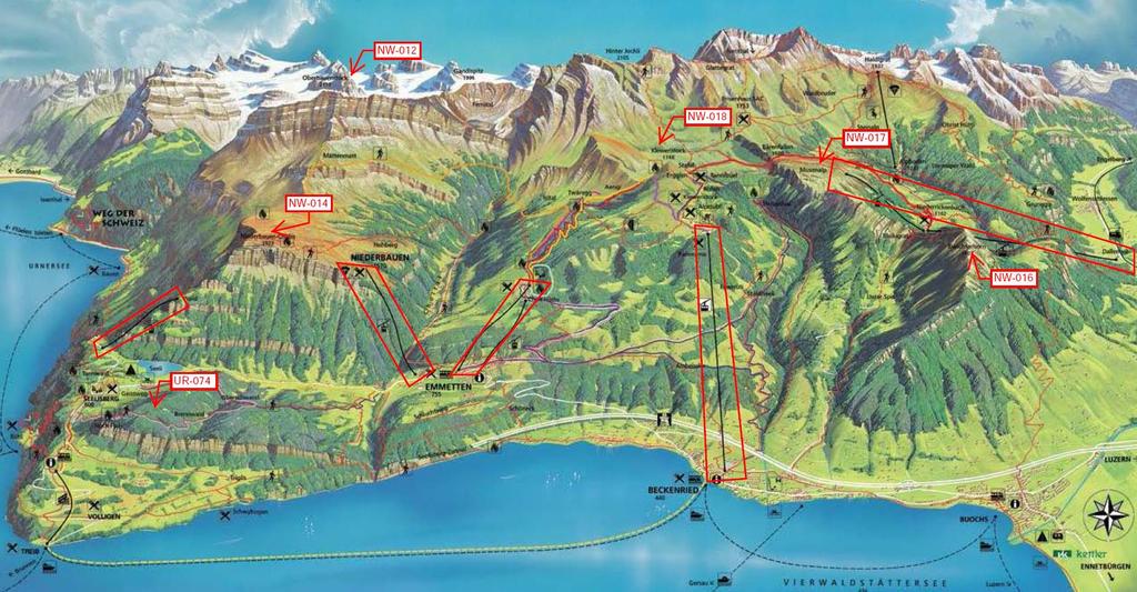
Klewenalp Region HB/NW-012 / NW-014 / NW-016 / NW-017 / NW-018 / UR-074
|
|
|
- Josephine Jefferson
- 5 years ago
- Views:
Transcription
1 Klewenalp Region HB/NW-012 / NW-014 / NW-016 / NW-017 / NW-018 / UR-074 by Paul HB9DST Visitors to Lucerne will frequently hear about Mount Pilatus, which dominates the city skyline, and for SOTA activators Pilatus' nearby summit of Tomlishorn (HB/NW-011) is quite easy. However, about half an hour southeast of Lucerne you will find the attractive Klewenalp Region. It offers a number of SOTAs that are also quite accessible, including two counting for the difficult to activate Canton of Uri (HB/UR- XXX). In addition, on the way there you pass by two additional famous and family-friendly SOTA summits: Stanserhorn HB/NW-015 (which involves riding up a "convertible" open-air gondola) and Bürgenstock HB/NW-019 (where you can ride up Europe's highest open-air elevator). Getting to the Klewenalp Region is easy with either a car or public transportation (via train, bus or even commercial ferry boat on Lake Lucerne). For most of these summits you are well advised to take one of the cable cars that service the area. These are indicated on the second map below with the red polygons. They vary in seating capacity and frequency, and on a nice day you might spend a bit of time waiting for your turn to ride. In addition, you might elect to enjoy the scenery and do some extra hiking by "mixing and matching" various combinations of summits and cable cars, going up and down from different spots. The summits to be discussed in this article (in this order) are: HB/UR-074 Brandegg (1108 meters) HB/NW-014 Niderbauen Chulm (1923 meters) HB/NW-012 Oberbauenstock (2117 meters) HB/NW-018 Klewenstock (1748 meters) HB/NW-017 Musenalper Grat (1785 meters) HB/NW-016 Buochserhorn (1807 meters)

2
3

4 HB/UR-074 Brandegg (1108 meters) Activation date: May 9, 2013 If you are working on the HB9SOTA Edelweiss certificate/cowbell, you will find that there are few summits in the Canton of Uri that are possible without considerable effort and difficulty. HB/UR-074 is one of them and thus has been activated numerous times. I did this joint activation with Peter HB9TVK. Our point of departure was Seelisberg, which can be reached by bus or with a funicular railway from the lakeside town of Treib. I took the bus here, and Peter drove his motorcycle to the parking lot for the funicular summit station. The hike up was relatively easy. From Seelisberg you won't find hiking signs going to Brandegg because there is no official hiking trail going to this nondescript summit. Instead, first follow the signs to Höch Flue, continue on the path and then look for the highest point. Having a GPS along will help you know when you are in the activation zone. In our case, we fought through some brush until we were safely within the activation zone. The hike was roughly 3 km with an ascent of 344 meters and took just under an hour.

5 Near Höch Flue on the way to the summit, which itself is in a wooded area with no views at all. To the left in the background: Bürgenstock HB/NW-017, in the middle Vitznauer Stock HB/SZ-036. (photo courtesy of Peter HB9TVK).

.")
6 HB/NW-014 Niderbauen Chulm (1923 meters) Activation date: October 1, 2015 This is a very pleasant and only moderately difficult summit -- except if the wind is blowing 50 km/h with gusts exceeding 70 km/h as on the day I chose. The 2.6 km hike has an ascent of 397 meters and took me just a few minutes over an hour. It's a very popular (even on a very windy day), but the activation zone is quite large with plenty of room for antennas. First you ride the Emmetten/Niderbauen cable car. It holds only 8 people at once, and on a nice day there will be a considerable waiting line (also given the fact that this leads to a popular hang-gliding takeoff point). From the summit station the first half of the hike has only a little gain in elevation, most of the work is in the second half. Niderbauen gondola valley station, has limited parking and is easily accessible by bus.
 Much of the steep")

7 View of the summit after getting off the cable car (it's the one in the left rear) Much of the steep part of the trail is paved with these stones. To the upper right is the summit station of the cable car.


8 The last third of the hike goes up this slope and then on the ridge to the left. The activation zone is quite large, which is good because this summit is a popular destination in good weather.

9 HB/NW-012 Oberbauenstock (2117 meters) (Not yet activated by HB9DST) This is the most difficult SOTA of all those in the Klewenstock region. As of late 2015, it has been activated just once, and the reports published on hikr.org give it a rating of at least T4. The logical starting point is once again the summit station of the Niderbauen cable car. According to wanderland.ch, this hike is 4 km in distance with an ascent of 627 meters. The estimated time required is just over 2 hours. To repeat, however, it is of above average difficulty.

10 Oberbauenstock as seen from Niderbauen Chulm. You hike up the ridge in the center and approach the summit from the right side in this photo.

11 HB/NW-018 Klewenstock (1748 meters) Activation dates: November 2, 2015 / March 13, 2013 (on snowshoes for the Winter bonus) This is one of the easiest summits in the group. Most efficient is to take the large gondola from Beckenried on the lake up to the Klewenalp summit station. From there, the hike up the summit is about 1.2 km with an ascent of 165 meters and takes roughly half an hour. Note that there is no formal trail for the final approach up the summit, you just hike up a steep grassy slope, but it not the least bit dangerous. In the winter you can even take a chair lift that brings you almost directly to the summit peak, and snowshoes are not necessarily needed.


12 The activation zone is not huge but has enough space for several antennas, and there are many posts to which you can lash a mast. Taken from the summit, the activator here is Uli HB9CGA. In the background you can see the Klewenalp summit station where the hike starts.
 to Niederrickenbach station.")

13 HB/NW-017 Musenalper Grat (1785 meters) Activation date: October 5, 2012 This SOTA is without doubt the easiest of all the ones in the Klewenalp region. You first take the 30- occupant gondola from Dallenwil (on the far western side of the region, just south of Stans) to Niederrickenbach station. You then transfer over to the smaller 4-person Musenalpbahn gondola (meaning possible wait times) that does not run on a set schedule but rather on demand. But on a nice day you don't worry about sufficient demand but instead a long waiting line. This brings you to the Ober Musenalp summit station, where there is a pleasant restaurant for a coffee, beer or small meal. From there, the Musenalper Grat is a trivial hike of 300 meters long, 38 meters ascent and takes less than 10 minutes. Unfortunately, the second cable car runs only until November 1, so snowshoe activations are difficult.

14 Niederrickenbach (valley) station of the Musenalpbahn, the second cable car which brings you all the way up to the Musenalp summit station. It holds 4 people, so there can be long waiting times on a nice day. The activation zone on the Musenalper Grat is quite large with room for multiple operators and antennas. Shown is Hugo HB9AFH experimenting with my AlexLoop.

15 HB/NW-016 Buochserhorn (1807 meters) Activation date: October 5, 2012 The logical place to depart for Buochserhorn is the Ober Musenalp summit station as described in the writeup for HB/NW-017 Musenalper Grat or, as Hugo HB9AHF and I did, continuing from Musenalper Grat for a double activation on that day. The hike to Buochserhorn is 2.5 km, involving an ascent of 261 meters and takes roughly 75 minutes. Most of the hike is straightforward, but at Bleikigrat there is a rocky section that can be very tricky (do not hike across this section when it is wet!). After the activation, rather than return back to the summit station at Ober Musenalp, we decided to hike down to the middle station at Niederrickenbach. This was just short of 4 km, with a descent of roughly 900 meters and require roughly 2.5 hours. We then took the cable car to the valley where Hugo had parked his car.


16 View of the Bleikigrat section as seen from Buochserhorn. One of the trickier sections of the Bleikigrat.

17 After crossing the Bleikigrat, it's smooth sailing to the Buochserhorn summit seen here.
HB/VS-078 Üssers Barrhorn
 HB/VS-078 Üssers Barrhorn Paul HB9DST, August 23, 2015 Summary: This was a HB9SOTA club project, an activation of the highest summit in Europe you can hike up without ropes or other equipment. The headline
HB/VD-034 La Dôle. February 22, 2015 Paul HB9DST
 HB/VD-034 La Dôle February 22, 2015 Paul HB9DST Summary: So many options, your choice will depend on conditions. As in previous hikes, most of the work is in the second half. Not a technically difficult
FROM JUTA TO ROSHKA via Chaukhi pass
 FROM JUTA TO ROSHKA via Chaukhi pass Duration: 1-2 days The hike can take one or two days, depending on how you plan it. I will focus on the 1-day version of the trek which takes 8-9 hours and starts in
(west) onto Charleston Boulevard. Drive 16 miles on Charleston and turn right into Red Rock
 onto Charleston Boulevard. Drive 16 miles on Charleston and turn right into Red Rock") Hike: North Peak and Ice Box Overlook up and back Trailhead: 2.5 miles up the Rocky Gap Road not mark Distance: 5 miles round trip Elevation gain: 2,694 feet Elevation Peak: 7,094 feet Time: 3 to 5 hours
Hike: North Peak and Ice Box Overlook up and back Trailhead: 2.5 miles up the Rocky Gap Road not mark Distance: 5 miles round trip Elevation gain: 2,694 feet Elevation Peak: 7,094 feet Time: 3 to 5 hours
Grizzly Peak A - East Ridge July 15, 2012
 Grizzly Peak A - East Ridge July 15, 2012 Difficulty: Difficult Class 2/Class 3 Upper Elevation: 13,995 feet Trailhead Elevation: 11,360 feet Elevation Gain: 3,000 feet Round-trip Length: 6.0 miles Trailhead:
Location: Height: Access: Distance: Elevation: Season: Difficulty: Lat/Long: Directions:
 Upper Eagle Falls Upper Eagle Falls (~20 ft.) is a short hike up from the roadside at the Eagle Falls picnic area. It is very difficult to get a parking spot here during the day, so it is recommended to
Below is an example of a well laid-out template of a route card used by the Sionnach Team which is a good format to begin with.
 Route Card A route card is used as a navigational aid to hill walkers by setting out a step by step plan for an intended hike. It is good practice to make out a route card before every hike you or your
Route #1) Mt. of the Holy Cross - North Ridge
 Mt. of the Holy Cross - North Ridge") Climbing 14ers can be very dangerous, please read the Mountaineering Safety Page and make sure you have a map+compass and can use them effectively, without the help of electronic devices. Route #1) Mt.
Climbing 14ers can be very dangerous, please read the Mountaineering Safety Page and make sure you have a map+compass and can use them effectively, without the help of electronic devices. Route #1) Mt.
Route Combo) Mt. Bierstadt - Bierstadt, Sawtooth, Evans
 Mt. Bierstadt - Bierstadt, Sawtooth, Evans") Climbing 14ers can be very dangerous, please read the Mountaineering Safety Page and make sure you have a map+compass and can use them effectively, without the help of electronic devices. Route Combo)
Climbing 14ers can be very dangerous, please read the Mountaineering Safety Page and make sure you have a map+compass and can use them effectively, without the help of electronic devices. Route Combo)
C E N T R A L C A T S K I L L S
 120 C E N T R A L C A T S K I L L S Central Catskills Once out of the southern parts of the Catskills, the Long Path enters the more well traveled and civilized regions. The trail joins the Devil s Path,
Piestewa Peak/Dreamy Draw Trail Guide
 Piestewa Peak/Dreamy Draw Trail Guide Trail #1A - Perl Charles Memorial Trail Length: 4.8 miles Elevation: 2,200 ft. - 1,340 ft. Difficulty: Moderate to difficult The Perl Charles trailhead is located
RUSSIA. Elbrus. I
 RUSSIA Elbrus RUSSIA Elbrus Mount Elbrus is the highest peak in Russia and Europe and although many mountaineers visit the area to climb the mountain, there are also many other attractions here. On the
L U N C H C R E E K T R A I L GLACIER NATIONAL PARK
 D I R T I N M Y S H O E S L U N C H C R E E K T R A I L GLACIER NATIONAL PARK Lunch Creek "Secret" Hike This short hike on the Lunch Creek Trail will knock your socks off! It's the perfect mix of length,
PERUVIAN ANDES ADVENTURES. TOCLLARAJU CLIMB or ISHINCA + TOCLLARAJU CLIMBING. Tocllaraju 4 Days Ishinca + Tocllaraju 5 or 6 days
 PERUVIAN ANDES ADVENTURES TOCLLARAJU CLIMB or ISHINCA + TOCLLARAJU CLIMBING Tocllaraju 4 Days Ishinca + Tocllaraju 5 or 6 days PEAKS Tocllaraju: 6034m (19797 ft) Grade: D / Hard / Some steep & technical
KILIMANJARO 2018 RUN & TREK February 28 March 12
 KILIMANJARO 2018 RUN & TREK February 28 March 12 Wednesday 28 Feb Depart USA to Kilimanjaro International Airport, Tanzania, Africa Thursday 01 March Arrive Kilimanjaro. Met upon arrival at the Kilimanjaro
Trail Beginning Elevation: 7553 ft The Poison Creek Trailhead is located at the end of National Forest Road 646E (NF-646E).
.") West Mountain Trails Poison Creek Trail #134 Length: 2.9 miles (4.7 km) Difficulty Horseback: A good trail for the first time west mountain rider, some steep sections Hiking: Most Difficult USGS Maps:
West Mountain Trails Poison Creek Trail #134 Length: 2.9 miles (4.7 km) Difficulty Horseback: A good trail for the first time west mountain rider, some steep sections Hiking: Most Difficult USGS Maps:
Hiking Las Vegas.com
 Hike: Mt. Wilson via First Creek Canyon route Trailhead: First Creek marked Distance: 10 miles up and back Elevation gain: 3,400 feet Elevation of Peak: 7,070 feet Time: 7 to 9 hours (up and back) Difficulty:
Kuruwita Erathna Trail to Sri Pada (Adam s Peak)
") Kuruwita Erathna Trail to Sri Pada (Adam s Peak) Trail Difficulty: Easy Moderate Strenuous Tough Trail Head: Adevikanda, Erathna (near entrance to mini-hydro power plant) Nearest Town: Erathna Nearest
Kuruwita Erathna Trail to Sri Pada (Adam s Peak) Trail Difficulty: Easy Moderate Strenuous Tough Trail Head: Adevikanda, Erathna (near entrance to mini-hydro power plant) Nearest Town: Erathna Nearest
Self-Guided Walk Langdale Pikes. Start & Finish: NT car park (free to members) at Sticklebarn - on the right just beyond the New Dungeon Ghyll hotel.
 at Sticklebarn - on the right just beyond the New Dungeon Ghyll hotel.") Self-Guided Walk Langdale Pikes Key Information These mountains form a collection of spires and cliffs on the north side of Langdale. This walk visits four of the main tops Pavey Ark, Harrison Stickle,
Self-Guided Walk Langdale Pikes Key Information These mountains form a collection of spires and cliffs on the north side of Langdale. This walk visits four of the main tops Pavey Ark, Harrison Stickle,
Tiger Mountain State Forest:
 98 60 hikes within 60 miles: SEATTLE 20 Tiger Mountain State Forest: West Tiger Mountain Three Loop i KEY AT-A-GLANCE INFORMATION Length: 5.1 miles round-trip Configuration: Loop Difficulty: Moderate difficult
LOWER SPRING CANYON - CAPITOL REEF
 LOWER SPRING CANYON - CAPITOL REEF Rating: Moderate Hike Length: 5-7 hours (10-11 miles) Gear: Standard Hiking Gear Maps: Fruita, UT; Twin Rocks, UT; Water: A filterable spring a bit over 1/2 way. Recommend
Jumbo Glacier Resort Master Plan Appendix 2-A
 Jumbo Glacier Resort Master Plan Appendix 2-A Avalanche Studies and Reports prepared by P. Schaerer of Stetham & Associates Pheidias Project Management Corp. Copyright June, 2005 JUMBO
Saas- Fee, Switzerland Pearl of the Alps
 Saas- Fee, Switzerland Pearl of the Alps Background Saas- Fee (1800m) is the main village in the Saastal (Saas Valley) and is a municipality in the district of Visp in the canton of Valais in Central Southern
U.S.A. W0N - Nebraska
 Summits on the Air U.S.A. W0N - Nebraska Association Reference Manual Document Reference S100.1 Issue number 1.0 Date of issue 1 st February 2014 Participation start date 1 st February 2014 Authorised
County Line trail - Miller Peak to Little Navaho
 County Line trail - Miller Peak to Little Navaho 7-17-2008 This hike features a portion of the County Line trail in the Teanaway that receives extremely little use despite offering a spectacular ridge-run
The height of Machu is 6630m on the Swiss map, 6612m on the Russian map and 6603m on Google Earth.
 Hispar Expedition 2017 Expedition Final Report MEF reference: 17-42 Country and region visited: Pakistan, Hunza Valley, Karakoram. Objective To make the first ascent of Machu (6630m) by the southwest and
2015 Cordillera Central Mountains of Peru, Sullcon and Paca climbing Expedition
 Introduction The Cordillera Central (also called the Huarochiri or Pariacacca Mountains) is the closest Andean Mountain Range to Lima the Capital of Peru (see Map 1). It is located approximately 80 to
Friday October 3. Lower Javelina Trail - Level D. about 3 miles, less than 500. Hike Contact: Joel Tormoen
 Friday October 3 Lower Javelina Trail - Level D. about 3 miles, less than 500 Hike Contact: Joel Tormoen joeltormoen@gmail.com Depart WB trailhead 8:00 am - return before 11:00 am This quite easy hike
Route #2) Mt. Massive - Southwest Slopes
 Mt. Massive - Southwest Slopes") Route #2) Mt. Massive - Southwest Slopes Difficulty: Class 2 Ski: Advanced, D6 / R2 / III Exposure: Summit Elevation: Trailhead Elevation: Elevation Gain: Round-trip Length: Trailhead: County Sheriff:
Route #2) Mt. Massive - Southwest Slopes Difficulty: Class 2 Ski: Advanced, D6 / R2 / III Exposure: Summit Elevation: Trailhead Elevation: Elevation Gain: Round-trip Length: Trailhead: County Sheriff:
Appalachian Mountain Club
 Appalachian Mountain Club January 30, 2013 Groton Planning Board 754 North Groton Road Groton, NH 03241 Re: Re-opened public hearing regarding a request by EDP Renewables (Lessee), EXPX2/MAXAM (Owner)
PERUVIAN ANDES ADVENTURES. ARTESONRAJU CLIMB 6025m (19767 ft) Grade: D+ to TD/ Technical. Routes: The two routes to climb Artesonraju are;
 Grade: D+ to TD/ Technical. Routes: The two routes to climb Artesonraju are;") PERUVIAN ANDES ADVENTURES ARTESONRAJU CLIMB 6025m (19767 ft) Grade: D+ to TD/ Technical Routes: The two routes to climb Artesonraju are; *Via the Paron Valley South East Ridge 5 days (option for 6 with
PERUVIAN ANDES ADVENTURES ARTESONRAJU CLIMB 6025m (19767 ft) Grade: D+ to TD/ Technical Routes: The two routes to climb Artesonraju are; *Via the Paron Valley South East Ridge 5 days (option for 6 with
Royal Gorge Far Out Trail to Le Point
 Royal Gorge Far Out Trail to Le Point Direction to trailhead: From East Ridge Campground: Drive west from Canon City on US 50 to County Road 3A, the entrance road to the Royal Gorge Park. Turn left onto
CIEC 9 PEAKS AWARD SUPPLEMENT POSSIBLE ROUTES FOR THE 9 PEAKS AWARD TRIP
 CIEC 9 PEAKS AWARD SUPPLEMENT POSSIBLE ROUTES FOR THE 9 PEAKS AWARD TRIP As you plan your trip, be aware of 3 regulations in this wilderness: 1. Camp only in designated campsites. 2. No campfires allowed.
South East Wales Hang Gliding and Paragliding Club Ltd
 Section Release/Amendment Summary Rev Date All Initial issue 1 07/12/2016 Created By: Reviewed By: Approved By: Steve Millson Safety Officer Chris Jones Avon Committee Management Representative: Page 1
Peak to Peak Mega Challenge FAQs
 Peak to Peak Mega Challenge FAQs Friday 27- Sunday 29 April 2018 1 The Peak District The itinerary Arrive on the Friday evening to spend the night at Losehill Youth Hostel. Your leaders will be there to
Mt. Thielsen Trip Report: April 29, 2012
 Mt. Thielsen Trip Report: April 29, 2012 Outing Organizer: Geoff Hance, with Brent McGregor Elevation Gain: 3,800 feet, over warming snow, with an exposed summit block Distance: About 9 miles round trip
Sheet n 35 La Roche de Vendeix (Vendeix s Rock)
") Sheet n 35 La Roche de Vendeix (Vendeix s Rock) Name: La Roche de Vendeix (Vendeix s Rock) Name of the village/town: La Bourboule, 63150 Owner: Inhabitants of Vendeix References: GPS : Latitude : 45 34
Sheet n 35 La Roche de Vendeix (Vendeix s Rock) Name: La Roche de Vendeix (Vendeix s Rock) Name of the village/town: La Bourboule, 63150 Owner: Inhabitants of Vendeix References: GPS : Latitude : 45 34
Camp Jack Wright PERMANENT ORIENTEERING COURSE (2004)
") Camp Jack Wright PERMANENT ORIENTEERING COURSE (2004) WHAT IS ORIENTEERING? The skill which enables a person to navigate with a map. In the competitive sport, the winner is the person who finishes in the
Camp Jack Wright PERMANENT ORIENTEERING COURSE (2004) WHAT IS ORIENTEERING? The skill which enables a person to navigate with a map. In the competitive sport, the winner is the person who finishes in the
Staunton River Trail to Hoover Camp and Fork Mtn. Relay Tower (Based on September 18, 2013 hike by Ron Singleton, Fredericksburg, Va.
 Staunton River Trail to Hoover Camp and Fork Mtn. Relay Tower (Based on September 18, 2013 hike by Ron Singleton, Fredericksburg, Va.) The President's Cabin (The "Brown" House) at Camp Hoover. Sign on
Skiing and Snowshoes on Un-groomed Fernan Saddle Terrain
 Skiing and Snowshoes on Un-groomed Fernan Saddle Terrain Three ski or snowshoe routes are available from the Fernan Saddle Parking Lot which either do not cover routes ordinarily groomed for snow machine
TREK THE ROCKIES ABOUT THE CHALLENGE TREK THE ROCKIES FOR HIGHLAND HOSPICE CANADA TREK DEMANDING
 TREK THE ROCKIES CANADA TREK DEMANDING ABOUT THE CHALLENGE The Canadian Rockies are justifiably world-famous for their magnificent scenery: the combination of impressive, jagged mountains, bright turquoise
Byelorussian Battlefields
 Byelorussian Battlefields All Flames Of War battles need terrain! Battles in the Second World War were rarely fought over open plains with unobstructed lines of sight. In Flames Of War, wide open tables
GIFFORD PINCHOT NATIONAL FOREST
 GIFFORD PINCHOT NATIONAL FOREST 9341 Wright Meadow 93 Spencer Meadow Spencer Butte 4247' 30 30A 19 24 80 31C Lewis River Lower Falls 5 Quartz Creek 90 Taidnapam Falls Upper Falls 31 Spencer Peak 3861'
KUSHILAND Expeditions & Tour Safaris Ltd
 KILIMANJARO TREK MACHAME ROUTE TOUR CODE KMC 02 7 DAYS MACHAME ROUTE Kilimanjaro s Machame Route, often referred to as the Whiskey route, is more scenic and is longer than Marangu. The minimum duration
Cherokee Hiking Club Trail Blurb
 Cherokee National Forest Trail #164 Distance: 6.2 miles Elevation Change: 2280 feet High Point: 3692 feet (Waucheesi Mountain) Low Point: 1412 feet (Wildcat Creek) Trail Rating: Moderately Strenuous (NW
1. Waterfall Gully Mt Lofty. 5 Of the Best Hikes in Adelaide
 Adelaide is a beautiful city, and one of the most incredible things about Adelaide is the quality of bushwalking available on the suburban fringe. It is surrounded by the Mt Lofty Ranges, and much of the
Little Grand Canyon near Pomona, Illinois
 Little Grand Canyon near Pomona, Illinois Below: View of the trail and the terrain created using the Map My Hike app Below: Summary of the hike created using the Map My Hike app Presented by: Jennifer
Germany - Bavarian Lake Road Cycle Tour 2019 Individual Self-guided 7 days / 6 nights
 Germany - Bavarian Lake Road Cycle Tour 2019 Individual Self-guided 7 days / 6 nights On the edge of the Bavarian Alps you will find a wonderful landscape with rivers, lovely lakes and mountain. The area
Mount Kilimanjaro Climbing via Rongai Route 8 day-itinerary
 Mount Kilimanjaro Climbing via Rongai Route 8 day-itinerary Total hiking distance: Approximately 70 kms The Rongai route ascends Kilimanjaro from the north-eastern side of the mountain, along the border
Figure 1 Understanding Map Contours
 Figure 1 Understanding Map Contours The light brown lines overprinted on topographic maps are called contour lines. They indicate the elevation above sea level of land features and thus permit you to view
The Cleo s Bath North Side Hike
 The Cleo s Bath North Side Hike This hike is a cross-country hike from Pinecrest Lake to the north side of Cleo s Bath. It is quieter and much less crowded than the normal route, which goes up the south
Lava Mountain Trail Distance: Elevation Range: Trail Type: Difficulty: Season: Driving Distance: Driving Time: USGS Maps: Pros Cons
 Lava Mountain Trail Distance: 13.4 miles (including the side trip to North Star Lake) Elevation Range: 5900'-8330' Trail Type: singletrack Difficulty: moderate Season: late June-October Driving Distance:
7 DAYS RONGAI ROUTE ON KILIMANJARO ROUTE
 7 DAYS RONGAI ROUTE ON KILIMANJARO ROUTE Day 1: Drive to Kilimanjaro National Park Rongai Gate (Nale Moru), Hike to Simba Camp Drive to the attractive wooden village of Nale Moru (about 2 hours including
ODYSSEIA-IN AND ZIG ZAG HOLIDAYS TRAVEL TEAM SOFIA 1000, 20-V АL. STAMBOLIISKI, (ENTRANCE FROM LAVELE STR.) ТЕL: , FAX:
 ТЕL: , FAX:") High Mountain Traverses and Via Ferrata BULGARIA TRIP DOSSIER Focus: Strenuous Hiking and traverse Duration: 9 days Period: July 1 August 30 Trip Highlights: Traverse on the highest peak on the Balkans
High Mountain Traverses and Via Ferrata BULGARIA TRIP DOSSIER Focus: Strenuous Hiking and traverse Duration: 9 days Period: July 1 August 30 Trip Highlights: Traverse on the highest peak on the Balkans
Retrieving a Free Flight Model at 1200m
 Retrieving a Free Flight Model at 1200m Fernando Zito, fzito@hotmail.com Between April 30th and May 3rd the 68 Free Flight National Championship was held in Angaco, San Juan, Argentina. It was also the
Scenic Swiss Alps by Rail The Grand Train Tour of Switzerland
 SwissVistas.com Scenic Swiss Alps by Rail The Grand Train Tour of Switzerland TOUR SWITZERLAND BY RAIL IN LEGENDARY TRAINS Activity Level Our Adventures are designed for people who are energetic, active,
Griffith Park Trail Run Trail Guide Click for
 The Griffith Park Trail Run by Hike- LosAngeles.com Griffith Park Trail Run Trail Guide Click for downloadable cell phone guide and map from EveryTrail. DISTANCE: 4.55 Miles ELEVATION: 1280' ELEVATION
Mt. Massive Southwest Slopes
 Mt. Massive Southwest Slopes Difficulty: Class 2 Exposure: Summit Elevation: 14,421 feet Trailhead Elevation: 10,500 feet Elevation Gain: 4,050 feet Round-trip Length: 8.00 miles Trailhead: N. Halfmoon
Trail Phasing Plan. Note: Trails in the Clear Creek Canyon area (Segments will be finalized in the future to minimize wildlife impacts
 Note: Trails in the Clear Creek Canyon area (Segments 2 5 and a future JCOS connection) will be finalized in the future to minimize wildlife impacts Trail Phasing Plan P Parking 3 Easy Trail Intermediate
THE RESERVE III AT SUGAR MOUNTAIN, NORTH CAROLINA
 THE RESERVE III AT SUGAR MOUNTAIN, NORTH CAROLINA Information Memorandum AUGUST 2015 THE RESERVE III Contents I. THE PROPERTY... 3 OVERVIEW... 3 READY TO BUILD... 4 INEXPENSIVE CONSTRUCTION... 5 ADDITIONAL
Saas Fee (1800m) Switzerland Pearl of the Alps
 Switzerland Pearl of the Alps") Saas Fee (1800m) Switzerland Pearl of the Alps 1. Background In the next- door valley to the world famous Zermatt, just 9 miles away, Saas- Fee (1800m) is the main village in the Saastal (Saas Valley)
Saas Fee (1800m) Switzerland Pearl of the Alps 1. Background In the next- door valley to the world famous Zermatt, just 9 miles away, Saas- Fee (1800m) is the main village in the Saastal (Saas Valley)
Kirigalpoththa Nature Trail Horton Plains National Park
 Kirigalpoththa Nature Trail Horton Plains National Park Trail Difficulty: Easy Moderate Strenuous Tough Trail Head: Horton Plains Visitor Centre Nearest Town: Pattipola Nearest City: Nanu-Oya Access to
Cycling el Mundo Guides Guides for Outdoors Adventures
 Cycling el Mundo Guides Guides for Outdoors Adventures ISSUE 01 JANUARY 2013 WILDERNESS Hiking and Packrafting the Hollyford & Pyke River (New Zealand) The Hollyford Track, combined with the Pyke Big Bay
Typical avalanche problems
 Typical avalanche problems The European Avalanche Warning Services (EAWS) describes five typical avalanche problems or situations as they occur in avalanche terrain. The Utah Avalanche Center (UAC) has
COSTA BLANCA MOUNTAIN WALKERS - WALK DESCRIPTION. Visit for more walks descriptions in Spain
 COSTA BLANCA MOUNTAIN WALKERS - WALK DESCRIPTION Visit www.walksinspain.org for more walks descriptions in Spain Walk description originally prepared by:- Ralph Phipps Last Updated 25th Sep 2015 Title
Note: Coordinates are provided as Universal Transverse Mercator UTM Zone U21, North American Datum 1983 (NAD 83).
.") Northern Traverse Route Description The Northern Traverse (formerly the North Rim Traverse) is an unmarked and rugged backcountry hiking route. It is known be a demanding hike, because of its terrain and
Northern Traverse Route Description The Northern Traverse (formerly the North Rim Traverse) is an unmarked and rugged backcountry hiking route. It is known be a demanding hike, because of its terrain and
ID: 283 Distance: 6.2 miles Height gain: 500 Metres Map: Explore OL 19 Contributor David and Chris Stewart
 Walkingworld Wild Boar Fell ID: 283 Distance: 6.2 miles Height gain: 500 Metres Map: Explore OL 19 Contributor David and Chris Stewart Features Birds, Great Views, Hills or Fells Description: Wild Boar
Machame 7 Days 6 Nights
 Machame 7 Days 6 Nights If Marangu is the Coca Cola route, then the Machame Route is the Whiskey route. It is the second most popular and one of the most scenic routes on the mountain. All climbers sleep
Epic Family Adventure in the Austrian Alps. 9 Days
 Epic Family Adventure in the Austrian Alps 9 Days Epic Family Adventure in the Austrian Alps On this extraordinary family adventure through Germany, Austria and Italy, cross the mighty Alps on one of Europe's
Northern Greece: Olympos & Pieria - Greece
 S-CAPE TRAVEL - EMAIL: INFO@S-CAPETRAVEL.EU - TELEPHONE +34 985846455 - WWW.S-CAPETRAVEL.EU style : level : duration : comfort : period: code: TREKKING WALKING Selfguided 8 days Jun Jul Aug Sep Oct GRSW020
Life in the Alpine Zone
 Life in the Alpine Zone Conditions change as elevation is gained. For every 1,000 foot increase in elevation, temperature drops about 3-5 degrees Fahrenheit and precipitation increases approximately 8
PERUVIAN ANDES ADVENTURES. EXPEDITION Climbing Alpamayo & Huascaran. PEAKS: Maparaju 5350m Alpamayo 5947m Huascaran Sur 6768m
 PERUVIAN ANDES ADVENTURES EXPEDITION Climbing Alpamayo & Huascaran PEAKS: Maparaju 5350m Alpamayo 5947m Huascaran Sur 6768m 23 days Huaraz to Huaraz Grade: Technical, physically demanding This is a comprehensive
GOLDEN EARS PROVINCIAL PARK
 GOLDEN EARS PROVINCIAL PARK Trail Information as of October 10 th 2015 Do not underestimate the mountainous wilderness of Golden Ears Provincial Park. The combination of rugged terrain and rapidly changing
Three Sisters Wilderness Oct. 2009
 Three Sisters Wilderness Oct. 2009 I was in Bend, OR and had the whole day to travel back to Boise so I decided to take a hike to the popular Green Lakes and summit the South Sister in Three Sisters Wilderness.
CONTRIBUTOR REWARDS PROGRAM
 CONTRIBUTOR REWARDS PROGRAM Here s how it works... Document + submit an adventure Earn Adventure Points (AP) when it s published Get rewards: awards, prizes, pro deals + earn cash Page Document + submit
BRR Leg 1 (4.0 miles, Easy)
") BRR Leg 1 (4.0 miles, Easy) Min 3881 Max 4948 Ascent +36 Descent -1027 0.0 Start (Grayson Highlands State Park Visitor Center) 4.0 Grayson Highlands State Park Office & Gate, on L (EZ 1) Leg Notes: Minimal
BRR Leg 1 (4.0 miles, Easy) Min 3881 Max 4948 Ascent +36 Descent -1027 0.0 Start (Grayson Highlands State Park Visitor Center) 4.0 Grayson Highlands State Park Office & Gate, on L (EZ 1) Leg Notes: Minimal
Hiking Las Vegas.com
 Hike: Juniper Peak up and back Trailhead: Oak Creek Canyon marked Distance: 5.5 miles round trip Elevation gain: 2,200 feet Elevation peak: 6,109 feet Time: 4 to 5 hours - Up and back Difficulty: 3 Danger
The Cirque. Everything you need to know about climbing the Lotus Flower Tower. Southeast Face 2000 feet 19 pitches up 10 rappels down 5.
 The Cirque Cirque of the Unclimbables, Northwest Territories, Canada Created: Sept 4, 2011 Everything you need to know about climbing the Lotus Flower Tower Southeast Face 2000 feet 19 pitches up 10 rappels
Regatta Venue Information
 Regatta Venue Information Lucerne, Switzerland Event World Cup III Lucerne, Switzerland 13th 15th July 2018 Event website: http://www.worldrowing.com/events/2018-world-rowing-cup-iii/event-information
Adventure Travel Trip Itinerary
 Adventure Travel Trip Itinerary Mt. Kilimanjaro & Mt. Meru Climbs, Tanzania July 8 23, 2017 Leader: Bill Blazek Date Activity (distances are approximate) Accommodation, Notes Meals 1 Saturday July 8, 2017
Island Peak (Imja Tse )
") Popularly known as Imja Tse, Island Peak is the most climbing peaks in Nepal. It appears as an island of the icy sea while viewing form Dingbuche and on close inception, it exposes itself to be the most
Popularly known as Imja Tse, Island Peak is the most climbing peaks in Nepal. It appears as an island of the icy sea while viewing form Dingbuche and on close inception, it exposes itself to be the most
! Kilimanjaro Expedition
 ! Kilimanjaro Expedition Tanzania 2016 Climb Only: $4,350 (land costs) Feb 4-12; June 12-20; July 10-18; Aug 6-14; Sept 11-19; Dec 4-12 2016 Climb & Safari: $5,850 (land costs) Feb 4-15; June 12-23; July
Guide Book Excerpts. Wham Ridge 2006
 Guide Book Excerpts Wham Ridge 2006 Approach: Molus Lake / Elk Park / Vestal Creek Roach and Roach Description Take the Durango & Silverton Narrow Gauge train from either Durango or Silverton and get off
HIKING IN THE CANADIAN ROCKIES
 HIKING IN THE CANADIAN ROCKIES Distance Time Elevation y MORAINE LAKE TRAILS THE ROCKPILE 0.8 km (0.5 mi) 20 min 30 m (98 ft) Located adjacent to the Lodge, the short interpretive trail up the Rock Pile
New Guadernales 64 miles
 Cycling Route 64 miles Region: Fredericksburg, Texas Author: Gregory L. Kagay Catalog: 1022.1 Route Elevation Profile 5,000 Feet 4,000 3,000 2,000 Center Point Slope Bat Cave Summit Piedmont de San Antonio
Access. Road from start point (W01) to campground (W56) Water Taxi Pick-up (W03)
 to campground (W56) Water Taxi Pick-up (W03)") WAIKAREMOANA GREAT WALK 260 Series Map: W18 Waikaremoana NZ Grid GPS: Geodetic Datum 1949 Topo50 Maps: BG39 Ruatahuna & BG40 Waikaremoana Gaps: on WGS84 Topo250 Map: Sheet 10 To get to START: Exit Taupo
WAIKAREMOANA GREAT WALK 260 Series Map: W18 Waikaremoana NZ Grid GPS: Geodetic Datum 1949 Topo50 Maps: BG39 Ruatahuna & BG40 Waikaremoana Gaps: on WGS84 Topo250 Map: Sheet 10 To get to START: Exit Taupo
White Horse. For your own safety warn the MCA Coastguard Helicopter (01305) They have been known to low fly in this area
 They have been known to low fly in this area") Site Code 2.078 OS Grid Ref: SY 715 844 (Map 194) GPS: N50:39.514 Owned and farmed by: Nearest Phone: Casualty Units: W2:24:273 P & J Critchell Farm Osmington 01305 834314 Broadmayne or Sutton Poyntz County
Site Code 2.078 OS Grid Ref: SY 715 844 (Map 194) GPS: N50:39.514 Owned and farmed by: Nearest Phone: Casualty Units: W2:24:273 P & J Critchell Farm Osmington 01305 834314 Broadmayne or Sutton Poyntz County
Climbing Trikora and Mandala
 Climbing Trikora and Mandala After climbing Carstensz Pyramid and 3 surrounding peaks (Sumantri, Ngga Pulu, East Carstensz) in February, Anthony Nightingale, Dan Zokaites and Steven Drive Liwe, this time
CRANBERRY. Introduction
 Introduction Introduction The Cranberry Boulders are a group of 60 problems set in a beautiful mossy forest above the Cranberry Creek. The boulders are located approximately 36km south of Revelstoke on
Charnley Explorer June 24 - July 15, 2018 Bachsten Creek and the Charnley River. Second draft: 14 November 2017
 Charnley Explorer June 24 - July 15, 2018 Bachsten Creek and the Charnley River. Second draft: 14 November 2017 The best part of the original section one is now part of out Gibb Road Gorges trip. The dates
Access Statement for Leighton Hall
 Access Statement for Leighton Hall Introduction Leighton Hall is located 3 miles from J35 of the M6. Brown tourism signs are in situate to bring you right to the door. There is plenty of parking, with
Appalachian Mountain Club
 Appalachian Mountain Club June 3, 2013 Town of Alexandria Board of Selectmen 47 Washburn Road Alexandria, NH 03222 Re: Appalachian Mountain Club s comments on EDP Renewables building permit application
Colorado s forests are slated to lose thousands of miles of roads through the new OHV Route Designation process. DON T LET IT HAPPEN!
 Colorado s forests are slated to lose thousands of miles of roads through the new OHV Route Designation process. DON T LET IT HAPPEN! This packet identifies many roads that you may lose if you don t act.
Garibaldi Provincial Park Trail Conditions
 Garibaldi Provincial Park s August 2, 2018 Garibaldi Park is located in the coast mountain wilderness and the weather can be severe and unforgiving. Be well prepared, properly equipped and informed before
OFFER. Let s get active. Dates: Summer 2018 Number of guests: 2 / 4 persons
 OFFER Tour: Let s get active Duration: 8 days / 7 nights Dates: Summer 2018 Number of guests: 2 / 4 persons Accommodation 5* Hotels Day 1 3 Lucerne Hotel Schweizerhof www.schweizerhof-luzern.ch or Grand
South East Wales Hang Gliding and Paragliding Club Ltd
 Section Release/Amendment Summary Rev Date All Initial issue 1 12/12/2016 Created By: Reviewed By: Approved By: Martin Cray Committee Member Chris Jones Avon Committee Member Management Representative:
Km point Height Landmark Description 0 km m. Ordino. 3,5 km m. La Cortinada. 5 km m. Llorts. 10 km m.
 Organisation 0 km 1.280 m Ordino Starting from the centre of town along with by enchanting music and fireworks. We are surrounded by a crowd admiring our courage. It is the beginning of an unforgettable
In southern Upper Valais a very high avalanche danger will be encountered in some regions Edition: , 08:00 / Next update: 9.1.
 Page 1/6 In southern Upper Valais a very high avalanche danger will be encountered in some regions Edition: 9.1.2018, 08:00 / Next update: 9.1.2018, 17:00 Avalanche danger updated on 9.1.2018, 08:00 region
HAUTES ALPES SKI AREA GUIDE
 HAUTES ALPES SKI AREA GUIDE www.ernalowproperty.com +44 (0)20 7590 16254 enquiries@ernalowproperty.com Hautes Alpes, so close to the difference The Hautes Alpes encompasses many of the most popular resorts
Ceuta and Melilla (EA9) Association Reference Manual
 Association Reference Manual") Summits on the Air Ceuta and Melilla (EA9) Association Reference Manual Document Reference S138.1 Issue number 1.0 Date of issue 01-Apr-2017 Participation start date 01-Apr-2017 Authorised SOTA MT 01-Mar-2017
Summits on the Air Ceuta and Melilla (EA9) Association Reference Manual Document Reference S138.1 Issue number 1.0 Date of issue 01-Apr-2017 Participation start date 01-Apr-2017 Authorised SOTA MT 01-Mar-2017