WHITE PASS SCENIC BYWAY
|
|
|
- Toby Austin
- 5 years ago
- Views:
Transcription

1 WHITE PASS SCENIC BYWAY Corridor Management Plan Lewis County, Washington Gifford Pinchot National Forest Okanogan-Wenatchee National Forest Mount Rainier National Park
2 WHITE PASS SCENIC BYWAY Corridor Management Plan A guide to enhancing one of the Pacific Northwest s great recreational travel destinations Sponsoring agencies Lewis County, Washington Gifford Pinchot National Forest Okanogan-Wenatchee National Forest Mount Rainier National Park In partnership with Yakima County, Washington Naches, Washington Morton, Washington Mossyrock Washington Tacoma Power Washington State Department of Transportation Washington State Department of Fish and Wildlife Washington State Parks Prepared by Destination Packwood Parametrix Corridor Management Plan i
3 ii White Pass Scenic Byway
4 Contents Introduction The Byway and Its Resources Design Guidelines Visitor Services Site Enhancements Organizational Development Corridor Management Plan iii
5 Chapter 1 A MANAGEMENT PLAN for the WHITE PASS SCENIC BYWAY Corridor Management Plan 1-1
6 Purpose The White Pass Scenic Byway is an exceptional driving destination, offering travelers experiences of wildlife, outstanding scenic and natural landscapes, and outdoor recreation. The Corridor Management Plan for the byway focuses on improving the highway corridor as a destination for recreational travelers, and finding ways for tourism to contribute more to local economies. The planning process included extensive public involvement, including locally-based working committees and dozens of public meetings in communities throughout the corridor. Guidance from local stakeholders has shaped the plan, from the identification of improvement opportunities to the proposed look and feel of byway improvements. Completion of a Corridor Management Plan for the byway is intended to have several benefits. First, it is a tool for identifying local priorities for improvements, and helping local stakeholders organize to seek funding and implement projects. Second, the plan will be a valuable tool for seeking grant funding for projects in the corridor. Third, the plan will help byway communities be more coordinated in their marketing and tourism development activities. Corridor Management Plan 1-

7 Location of the Corridor and Scenic Byway Status The White Pass Scenic Byway is 124 miles long, and is currently designated as a state scenic byway between Mary s Corner (near I-5) and the intersection of US 12 and SR 410. It is also a designated US Forest Service Scenic Byway between Packwood and the US 12 / SR 410 intersection. Currently, the byway is not a designated National Scenic Byway. Following the completion of the Corridor Management Plan, local communities will have the opportunity to decide whether to apply for National Scenic Byway designation. Mount Rainier Mount St. Helens Mount Adams 1- White Pass Scenic Byway
8 A Great Place to Visit, a Great Place to Live The White Pass Scenic Byway passes through small communities, resource lands, river valleys, foothills, and alpine country. The region surrounding the byway includes privately-owned residential, agricultural, commercial and forestland properties, as well as state parks and wildlife areas, power projects with associated recreation lands, the Gifford Pinchot and Okanogan-Wenatchee National Forests and Mount Rainier National Park. The Corridor Management Plan for the White Pass Scenic Byway is intended to enhance livability of the byway region through tourism economic development, support for the corridor s rural communities, improved highway safety, and development of amenities that will benefit both residents and visitors. While the primary focus of the plan is on tourism, it is a type of tourism that supports local residents rooted in the character of local communities, and at a scale that will maintain the balance between local residents and outside visitors. Developed by a grass roots group of citizens from throughout the corridor, working together with agency representatives, the Corridor Management Plan focuses on strategies to enhance the corridor and conserve its unique resources. The plan is not a regulatory document, and does not limit any activities allowed on private lands by local planning, zoning, and environmental requirements. The plan also does not weaken or modify local control over land use decisions. The plan focuses on enhancements for the corridor that will provide more opportunities for recreation and tourism, and strengthen an important sector of the local economy. Corridor Management Plan 1-5
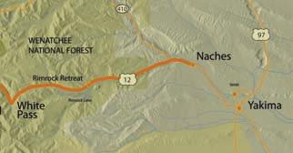
9 Regional Context The White Pass Scenic Byway is located in south central Washington State, about half way between Puget Sound and the Columbia River. The west portal to the byway is near the communities of Centralia and Chehalis, and the east portal is near Yakima, the largest city in central Washington. The west end of the byway connects to the I-5 corridor, with average traffic volumes of over 40,000 vehicles per day, and over 5 million residents live within a two-hour driving radius of the intersection of the byway and I-5. The corridor rises from lowlands on both ends of the byway to a 4500 high pass at the crest of the Cascade Mountains. Mount Rainier National Park is to the north, Mount St. Helens is to the south, and the road system through the Gifford Pinchot National Forest connects to the Columbia River Gorge. The byway passes through an exceptionally diverse range of habitats, geological features, and river valleys that set it apart from other recreational driving opportunities in the region. 1- White Pass Scenic Byway

10 The regional setting for the White Pass Scenic Byway corridor Corridor Management Plan 1-

11 The White Pass Scenic Byway Corridor 1- White Pass Scenic Byway


12 Corridor Management Plan 1-
13 VISION, THEMES, and GOALS 1-10 White Pass Scenic Byway
14 Vision The White Pass Scenic Byway will provide an exceptional traveler experience combining improved information and amenities, and vibrant local communities with unique character and hospitality. As the byway becomes better recognized as a travel destination of regional and national significance, more travelers will plan multi-day itineraries to experience the byway. The byway will be recognized as one of Washington State s premier wildlife viewing destinations. Wildlife viewing locations like Swofford Pond, Woods Creek, Riffe Lake, Timberwolf Mountain and other locations throughout the byway will be linked to provide wildlife tours for viewing a variety of birds, fish and mammals. The Oak Creek Wildlife Area will develop into Washington State s single best opportunity for a wildlife viewing experience. Following completion of facilities in Naches and at its headquarters complex, Oak Creek Wildlife Area will draw travelers from throughout the region to view the elk, bighorn sheep, birds, and other wildlife that thrive in its diverse habitats. More and more visitors to Mount Rainier National Park and Mount St. Helens will be attracted to the undeveloped, wilder recreation opportunities available in the White Pass Corridor Management Plan 1-11
15 Byway corridor, and choose the byway as their access to those destinations. Loop trips that include Mount Rainier, Mount St. Helens, and portions of the byway will be part of more visits, increasing the number of Mount Rainier and Mount St. Helens visitors who also drive the byway and take advantage of byway communities as base camps for their trips. Other recreational projects in the region, for example the development of trail systems in the Cowlitz Wildlife Area, establishment of excursion rail service to Morton, the Naches rail-trail project and the proposed William O. Douglas Trail, will improve the range of activities available to travelers in the region, and enhance the byway as a destination. Water-based recreation, including fishing, rafting, and kayaking will continue to be popular, and draw visitors from around the region. A focus on winter recreation will help to maintain the tourism economy throughout the year, as corridor communities provide food, lodging, and services for alpine and cross-country skiers, snowshoers, and snowmobilers. Regional recreational stakeholders will partner with the Okanogan-Wenatchee and Gifford Pinchot National Forests, and Mount Rainier National Park to support their ongoing recreation programs. Byway communities will benefit from additional tourism revenues, and continue their processes of revitalization. Mossyrock, Morton, Packwood, and Naches will have healthy, walkable downtowns with a variety of restaurants, lodging opportunities, and retail shops that benefit local residents as well as travelers. Tourism development will be complemented by continuing recovery of the forest products industry, and other commercial economic development to provide a balanced and sustainable regional economy. The scenic byway management organization, supported by predictable and sustainable operating revenues, will develop and strengthen partnerships with stakeholder agencies and regional recreation and tourism organizations. Working in partnership with WSDOT, local governments, and state and local agencies, the byway will contribute to quality of life and quality of the environment throughout the region, growing to be a valued asset for communities, and one of the region s favorite travel destinations White Pass Scenic Byway
16 Byway Themes What s unique about the White Pass Scenic Byway? What are the most important aspects of the visitor experience? Byway themes are intended to articulate what the byway is about they help visitors understand what to expect about the byway, and they also provide byway stakeholders with a touchstone for the characteristics of the byway that are most important to emphasize and enhance. They are the basis for the story that the byway has to tell to visitors, providing an experience of the underlying character of the byway s resources and communities. Corridor Management Plan 1-13
17 Byway Theme #1 Washington s Wildlife Trail Rocky Mountain Elk, Bald Eagles, Mountain Goats, Bighorn Sheep, Marmots, Spawning Salmon, Black Bear, and so many more... The White Pass Scenic Byway is Washington State s best roadway for wildlife watching opportunities. From low elevation lakes to sub-alpine ridges, wet west-side forests to the open steppes of eastern Washington, from Mount St. Helens blast zone to Mount Rainier s lush meadows, US 12 and its adjacent public lands provide a range of wild habitats you won t find anywhere else in the state. In addition to high quality and diverse habitat, the corridor also provides many accessible locations for wildlife watching, making it relatively easy for visitors to see the sometimes elusive wild residents. Some of the highlights for wildlife watching in the US 12 region include: Washington State s largest salmon hatchery near Mossyrock Swofford Pond Wildlife watching park and future trails at Riffe Lake The Woods Creek watchable wildlife trail near Randle Trails and viewpoints inside the Mount St. Helens National Monument Packwood watchable wildlife site Skate Creek Road Mount Rainier National Park White Pass Goat Rocks Wilderness Rimrock Lake and Clear Lake Timberwolf Mountain Oak Creek Wildlife Area There is no better location in the state to see such a diverse collection of species and habitats. The White Pass Scenic Byway is Washington s Wildlife Trail White Pass Scenic Byway


18 Corridor Management Plan 1-15
19 Byway Theme #2 South Cascades Outdoor Playground The White Pass Scenic Byway is a recreational paradise in the shadow of Mount Rainier, Mount St. Helens and Mount Adams. Whether you enjoy camping, wilderness hiking, fishing, snowmobiling or even hang gliding, there are more outdoor recreational opportunities along the byway than anywhere else in the south Cascades region. In the summertime campgrounds are buzzing with activity as visitors enjoy the rivers, lakes, forests, and trails from their base camps. Early in the summer, when the high country trails are still covered in snow, forests and grasslands along the byway are coming to life with wildflowers and wildlife. Early fall can be the best season for hiking, as trails are snow-free, sub-alpine vegetation is beginning to change color, and mosquitoes have called it quits for the year. Later in the fall hunters come to the forest for some of the state s best deer and elk range. Of course, fish follow their own seasons, and there s almost always something to be caught. Wintertime brings visitors to the byway to enjoy the White Pass ski area, snowmobiling, backcountry skiing and snowshoeing. Whatever your outdoor activity, whatever the season, there s something to do along the White Pass Scenic Byway White Pass Scenic Byway
20 Corridor Management Plan 1-17
21 Byway Goals Improve the byway visitor experience Support enhancement of visitor activities and facilities in byway communities Support expanded recreation opportunities in the corridor Improve visitor information Emphasize hospitality in byway communities Improve the tourism economy of the byway and its communities Establish the byway as one of Washington s best wildlife watching destinations and support the development of Oak Creek Wildlife Area to provide a sustainable, high quality wildlife experience for more visitors year-round Improve awareness of the byway as a travel destination Increase number of overnight visitors to the byway Increase percentage of Mount St. Helens and Mount Rainier visitors using the byway as part of their itinerary Improve coordination between byway tourism providers Protect byway resources Participate in land use and land management planning processes by local government, state agencies, and federal agencies to represent recreation, tourism, and conservation interests in the corridor Develop sustainable byway facilities and organization Build lasting partnerships with community, local government, and agency stakeholders Establish a byway management organization with stable participation and funding Identify resources for maintenance and operation of new facilities prior to capital development 1-18 White Pass Scenic Byway

22 Corridor Management Plan 1-19

23 1-20 White Pass Scenic Byway
24 RESOURCES and the ROAD Corridor Management Plan 1-21
25 Protecting the Byway s Intrinsic Resources The intrinsic resources identified as contributing to the White Pass Scenic byway include outstanding examples of scenic vistas, opportunities to view indigenous wildlife, and access to resource-based outdoor recreation. The corridor management plan is intended to improve the visitor experience of these resources by improving access, interpretation, and traveler services along the corridor. The majority of the features that express these intrinsic resources along the byway are in public ownership, and protection or enhancement of intrinsic resources is included in the mandate of the land management agencies responsible for them. Where there are specific needs to protect or enhance a resource, they are included in the discussion of specific projects. Local Land Use Requirements The general character of the corridor is affected by local land use regulation, including county and city comprehensive plans and associated zoning ordinances. In addition, the two counties in the corridor also have Critical Areas and Shorelines Ordinances that protect sensitive natural 1-22 White Pass Scenic Byway
26 resources including wetlands, shorelines, and steep slopes. Both Lewis and Yakima counties are required to plan for growth management under Washington State s Growth Management Act (GMA). The intent of the GMA is to prevent urban sprawl by defining limited urban growth boundaries, and requiring protection of rural resource lands outside of urban areas. The GMA also requires designation and protection of specific rural resource lands and high quality habitat areas. Forest Management Private forest owners are subject to Washington state s Forest Practices Act. This legislation requires forest land owners to protect certain sensitive habitats, limits the size of clearcuts, and includes requirements for reforestation practices. Timber management for the two national forests on the byway is regulated by the Forest Plan for each forest. The forest plans define management requirements for harvest activities visible from a priority visual corridor, setting standards for acceptable change in visual character. As the lead agency for managing a large section of the byway, the US Forest Service is committed to maintaining and enhancing the scenic and recreational character of the byway. Wildlife Management Wildlife in the corridor is generally managed by Washington State Department of Fish and Wildlife, although habitat is managed by the underlying landowner or land management agency. The majority of high quality terrestrial habitat in the corridor is in public ownership, and should maintain its function for the foreseeable future. Tacoma Power and Lewis County PUD play a major role in maintaining the quality of the fisheries in the Cowlitz River and its tributaries, including the operation of salmon and trout hatcheries near Mossyrock. Requirements to maintain these fisheries are included in the FERC licensing requirements for the corridor power projects. Highly visible populations of Rocky Mountain Elk and Bighorn Sheep are maintained by the Oak Creek Wildlife Area, which is managed for the health and protection of these species, along with a range of other species that are supported by the high quality Oregon Oak, riparian, and shrubsteppe habitat protected in the wildlife area. Corridor Management Plan 1-23
27 The Highway as Transportation Facility Safety, Mobility, Recreation US 12 is a two-lane rural highway. Average daily traffic in the corridor (ADT) ranges from less than 1,500 near the Oak Creek Wildlife Area to about 9,000 at each end of the corridor near I-5 and Naches. In general, the highway has adequate capacity to meet current traffic volumes, and there are no identified high accident locations or high accident corridors along the byway. US 12 is designated by WSDOT as a highway of statewide significance, one of only three year-round passes over the Cascades. It is a critical freight route, and at times needs to accommodate unusually high traffic when I-90 is temporarily closed due to snow or rock slide. Keeping the highway open through the winter is a daily challenge. The highway also has several adjacent unstable rock slopes. Major maintenance projects to scale and stabilize rock slopes are frequent, and there are rockfall protection installations along the roadway in several locations near White Pass. Recommendations in the Design Guidelines section of the Corridor Management Plan suggest that recreational and aesthetic considerations be included in planning for snow and rock management near 1-24 White Pass Scenic Byway
28 the pass, however nothing in the plan is intended to limit WSDOT s ability to protect travelers or keep the highway open. WSDOT uses Route Development Plans (RDP) as the capital planning tool for state highways. An RDP was completed for the eastern section of the byway (from approximately Rimrock Lake to the US 12 / SR 410 intersection) in WSDOT anticipates completing an RDP for the remainder of the byway to I-5 in the next few years. The proposed site improvements included in the Corridor Management Plan will be incorporated into the analysis for the RDP. The RDP for the eastern section of the roadway includes several suggested improvements to accommodate recreational travelers and improve safety for the byway. First, the plan calls for widening the roadway to meet bicycle route standards (12 lane width and 4 shoulders) wherever it is currently deficient. This would widen the paved surface of the roadway by approximately four feet for several miles of roadway. This recommendation would improve the byway as a recreational facility and should not have any significant impacts on the intrinsic resources of the corridor. The plan supports the development of a safety rest area at the Tieton Work Center/ Hause Creek Campground site, included in the Corridor Management Plan, and access improvements to the Oak Creek Wildlife Area, also included in the CMP. During public outreach for the Corridor Management Plan process, several safety or mobility concerns for the west side of the byway were discussed by public meeting participants. These locations should be reviewed in the upcoming RDP process to evaluate the need for improvements: Larson Road, Mossyrock Beach Road, Mossyrock MP Glenoma Post Office Throughout Add turn lane Add turn lane Add flashing light to warn drivers of icy conditions in winter Add turn lane Explore options to reduce elk strikes Corridor Management Plan 1-25

29 1-26 White Pass Scenic Byway
30 Chapter 2 THE BYWAY AND ITS RESOURCES Corridor Management Plan 2-


31 2-2 White Pass Scenic Byway
32 Following the Rivers between Mount Rainier, Mount Saint Helens, and Mount Adams To the north, Mount Rainier rises over 14,000 feet the highest point in Washington State and fifth highest in the continental United States. To the south, the jagged crater of Mount St. Helens reminds visitors of its massive explosion in Even today its occasional smaller eruptions send clouds of ash and steam billowing into the southern sky. Further east, the graceful cone of Mount Adams looks over the arid steppe country of Eastern Washington. The White Pass Scenic Byway follows two river valleys that wind between the volcanic giants, the Cowlitz on the west side, the Tieton on the east, cresting at White Pass in the cascade subalpine zone. The story of the road is a story of mountains and rivers, the habitats they create, and the outstanding recreation opportunities they offer. Corridor Management Plan 2-
33 Corridor Overview A dream for more than 30 years, the new White Pass highway will be dedicated on Sunday, August 12, Although constructed primarily as a commercial route across the Cascade Mountains, White Pass Highway, just completed at a cost of 6-1/2 million dollars, will open up one of the finest outdoor recreation areas in the state. Seattle Post-Intelligencer, Friday, August 10, 1951 From the west, the White Pass Scenic Byway begins at its connection to Interstate 5, follows the Cowlitz River valley until it climbs over White Pass, then follows the Tieton River to the town of Naches. It winds from lowland farms and forests through the subalpine zone of White Pass, then descends to arid eastern Washington State. Traveling through a series of distinct life zones and ecotypes, the byway provides travelers with a range of opportunities for wildlife viewing, spectacular outdoor recreation, and places to explore the geology (and sheer beauty) of the volcanic landscape surrounding three of the United States most significant volcanic peaks. The highway itself was the last year-round connection through the Cascades completed in the Pacific Northwest, finally making the connection over White Pass in Intended as a direct freight route from Yakima to Puget Sound and the Interstate 5 corridor, it was also anticipated from the beginning as a major new recreational highway. Native American Cultures in the Corridor Native American cultures in the region took advantage of the varied landscapes of volcano country, organizing their lives around the resources that were available in the different ecosystems of the volcanic landscape. The region around Mount Rainier was inhabited by Native American peoples for thousands of years before European contact and settlement. At the time of European contact, Mount Rainier was an important spiritual presence for Native Americans throughout the larger region. The bands and tribes that now constitute the modern Yakama Indian Nation and Cowlitz Indian Tribe were the primary inhabitants of what is now the US 12 corridor. There were no clear boundaries between the traditional use areas of the people in the corridor. Where the groups came together there was sharing and overlap of resources, along with cultural mixing over the several thousands of years of interaction. In the high country use was seasonal, and many hunting and collecting areas were shared. Members of what are now the Cowlitz and Yakama tribes were trading partners, and there was 2-4 White Pass Scenic Byway
34 frequent social contact and intermarriage among the Yakama Indian Nation and the Cowlitz of the upper Cowlitz River area. Archeological evidence shows that there were people residing in this area four to five thousand years ago, and possibly as much as fifteen thousand years ago. Although the 1980 eruption of Mount St. Helens is the only major volcanic event since Euro-American settlement, archeological evidence indicates that native peoples lived continuously in the region through a number of periods of volcanic activity. On Mount Rainier, archeological remains found between volcanic tephra layers testify to the long-term presence of Indian people in the region and on the mountain. Contemporary descendents of the historical residents of the region retain distinctly different cultures and strong tribal identities. Although the details of treaty history vary, the Yakama Indian Nation and Cowlitz tribe are federally recognized sovereign governments that interact in a state-to-state relationship with the federal government. Each tribe is governed by an elected Tribal Council, and owns at least some tribal trust lands. The occupation of the region by tribal peoples has left a cultural legacy of sites and artifacts throughout the corridor. Although some of these sites have been documented, the great majority of them have not. Cultural sites are of continuing importance to tribes. Whether sites are documented or not, tribes have specific rights regarding protection of their cultural resources. Project development should include an investigation for potential cultural sites, consultation with tribes, and safeguards against disturbing cultural resources in cases where they are discovered during project development. Natural resources are also important as elements of the tribes cultural heritages, continuing cultural survival, and contemporary livelihood. Salmon play an important cultural and economic role in contemporary life, and the health of river systems and their watersheds are areas of great interest for each tribe. In general, Native American interests in the health of the natural world range from concern over site-specific habitats for culturally important plants or other resources, to the very large scale health of regional watersheds. Corridor Management Plan 2-5


35 Resource Lands Most of the White Pass Scenic Byway corridor is surrounded by working landscapes resource lands that are managed for food crops, ornamental plant production, forestry, and grazing. On the west side bulb and Christmas tree farms and some small acreages of food crops give way to timberland in the foothills, and pastures in the valley bottoms. Forest land on the west side of the pass is generally dense western hemlock and Douglas fir forest, giving way to subalpine conifers as the byway rises towards White Pass. On the eastern slopes of the Cascades the forest is dominated by ponderosa pine, with cinnamon colored bark and a vanilla scent that fills the air on warm days. Near Naches on the east end of the byway the landscape is filled with tree fruit orchards apples, cherries and pears and grape vineyards. The working landscapes of the corridor are both a reminder of traditional agriculture developed over generations, and a vital part of contemporary life in the corridor. Trips to see the bulb fields in bloom, cut a Christmas tree, or buy flats of cherries are part of the way of life in the corridor, and are also growing in popularity as tourist activities. For many visitors, agritourism in the corridor lowlands is a more important draw than the nationally famous mountain destinations of Mount Rainier and Mount St. Helens. Federal lands in the US 12 corridor have influenced the development of communities and economies almost from the earliest American settlement. Mount Rainier National Park, the Okanogan-Wenatchee National Forest, and the Gifford Pinchot National Forest make up a large share of the lands in the corridor. The purpose and management of those lands directly influences the development of the corridor and its communities. Commodity development on the Gifford Pinchot and Okanogan-Wenatchee National Forests has been in steady decline for decades, with a growing emphasis on recreation as a major use on national forest lands. 2-6 White Pass Scenic Byway

36 Mount Rainier is a regional icon, and has been an international travel destination for over 100 years. Following the eruptions of Mount St. Helens in 1980 the Mount St. Helens National Volcanic Monument developed into a second major tourist destination. The public lands which would eventually become Mount Rainier National Park, the Gifford Pinchot National Forest, and a portion of the Okanogan-Wenatchee National Forest were originally set aside as Forest Reserves under the authority of the Forest Reserve Act of As the early management structure of the nation s public lands developed, the boundaries and management responsibility for the public lands in the area changed several times until reaching the general boundaries of the current federally-owned public lands units in the corridor. Timber emerged as the dominant industry in the region in the early 1900 s, with large-scale logging operations made possible by the arrival of the Tacoma Eastern Railroad in Morton in Traveling from Morton to Mineral and then back to Tacoma, the railroad made it possible to ship raw logs and finished lumber from the US 12 corridor back to the port and railroad connections in Tacoma. For nearly 75 years the timber industry boomed in the region. Currently timber employment has been reduced by modernization and changes in public lands policy, however timber harvest and processing remains one of the foundations of the region s industrial economy. Mount Rainier National Park was established in 1899, becoming the nation s fifth National Park. Even before it was officially added to the growing list of National Parks, Mount Rainier was a popular recreation destination. By 1915 the Park was accommodating over 34,000 visitors per year, a staggering number considering the population of Seattle and Tacoma at that time Corridor Management Plan 2-


37 and the difficulty of traveling to the park. Today Mount Rainier National Park supports over 1,000,000 annual visits, including a high percentage of outof-state and international visitors. Peak period crowding is becoming an issue for the park, and park managers are supporting the development of appropriate recreational opportunities in the gateway regions to provide visitors with alternative destinations and itinerary options. Privately-owned resource lands include agriculture in the flatter tablelands and valley bottoms west of the Cascades, and in the Naches Valley east of the Cascades, and private timberlands on the hillsides bordering the Cowlitz River Valley. On the west side, agriculture in the corridor generally includes pasture lands, Christmas tree farms, and bulb farms. On the east side, agriculture in the Naches River Valley is primarily fruit orchards. Development of dams on the major rivers of the corridor the Cowlitz and the Tieton was a significant engineering challenge, and brought major change to the communities of the corridor. Completed in 1918, the Rimrock Dam on the Tieton River is primarily an irrigation reservoir. Irrigation systems using water from the Tieton River provide water for 28,000 acres in the arid lowlands between Yakima and Naches. Three dams on the Cowlitz provide power for the City of Tacoma and Lewis County PUD. From upstream to downstream the Barrier Dam, Mossyrock Dam, and Mayfield Dam each creates a lake with popular recreation facilities. Developed relatively recently between the early 1960 s and early 1990 s, the dams and their reservoirs were created after the development of communities in the corridor. The creation of Riffe Lake displaced the towns of Riffe and Kosmos, and remnants of the Kosmos town site can 2-8 White Pass Scenic Byway
38 still be seen in late summer when the lake levels are down. Rising over 600 feet from its bedrock foundations, the Mossyrock Dam is the highest in Washington State. Currently, timber harvest levels are beginning to rise again, but there is no expectation that they will return to pre-1980 s levels. The corridor economy is re-shaping itself. Timber remains the primary industrial base, but other segments of the economy are growing to provide a more diversified employment base. While the corridor s resource lands have always supported recreation, there is a new emphasis on enhancing the year-round tourism economy in the region as an important component of healthy rural communities. Corridor Management Plan 2-9
39 Corridor Communities An important part of the travel experience for a byway is the character of the byway communities. Much more than simply providing necessary traveler services, corridor communities allow travelers to experience the culture of the byway, make personal connections with local residents, and value the corridor as a place to live as well as a place to visit. Welcoming communities, with shops, restaurants, and friendly faces are some of the best places along the byway. A primary goal of the byway is to enhance the benefits of tourism for local communities. Major focuses include enhancing the travel experience for community visitors, improving travel information and wayfinding, and developing improved visitor amenities in byway communities White Pass Scenic Byway
40 Naches Located near the intersection of SR 410 and US 12, Naches has a small historic downtown and larger highway-related commercial strip along US 12. Roadside retail in Naches includes fresh local tree fruit in season apples, peaches, and pears as well as other seasonal produce. Naches has a few restaurants and a hotel for lodging. The ranger station for the Naches Ranger District of the Okanogan-Wenatchee National Forest provides visitor information. Several community projects are underway to enhance Naches historic downtown core, and provide visitor amenities. Naches was incorporated in 1921 and has a population of about 800. Rimrock Retreat A small resort area with a few hotels, general store, and vacation homes tucked on the banks of Rimrock Lake. The community is highly seasonal, offering camping, fishing, and boating through the summer then slowing down for the wintertime. US 12 is Rimrock Retreat s main street, and serves a bustling small community during the summer season. Packwood Packwood is the last major town on the west side of White Pass. Set at the base of the Tatoosh Range and on the banks of the Cowlitz River, Packwood is surrounded by dramatic natural landscapes, most of which are in public ownership. Packwood, located less than ten miles from the Ohanapecosh entrance to Mount Rainier National Park, also has a fairly direct connection to the Nisqually entrance via Skate Creek Road during the summer months. Packwood has several restaurants in its downtown core along US 12, also the town s main street, and offers a wide range of lodging. In addition to travelers visiting Mount Rainier, Mount St. Helens, and the Gifford Pinchot National Forest in the summer, Packwood provides lodging for White Pass skiers during the winter season. Randle Randle is a mostly residential community, with an active timber mill and the ranger station for the Cowlitz Valley Ranger District of the Gifford Pinchot National Forest. Randle is also the intersection between the White Pass Scenic Byway and the road connecting to the major roads through the Gifford Pinchot National Forest, FS 23, FS 25 and FS 99. This is the direct route to the Windy Ridge viewpoint of Mount St. Helens, and to a wide variety of outdoor recreation in the forest. Corridor Management Plan 2-11
41 Morton Morton is located at the intersection of US 12 and SR 7. Morton has a compact, historic downtown area and a contemporary commercial area at the highway intersection. Morton is the terminus of the rail line connecting from Tacoma to the Mount Rainier region, and is the home of one of the corridor s major annual events, the Logger s Jubilee. Morton was the terminus of the railroad connecting to Tacoma, and has been a major commercial and transportation hub since the early 1900 s. With two active lumber mills, Morton continues to be a commercial center for this area of the corridor. For travelers from the south, Morton is on the direct route to the Nisqually entrance of Mount Rainier National Park, via SR 7 and Ashford. Morton offers both lodging and food for travelers. Morton also provides the most convenient support services for travelers on the west and south sides of the mountain, including a hospital, full service grocery store, and laundromat. Morton is an incorporated city, with a population of about 1,000. Mossyrock Mossyrock is in the heart of the Lakes District. The city has recently completed a main street renovation, and the charming downtown includes restaurants, lodging, outfitters, and a small theater. Mossyrock is a popular base camp for travelers fishing the Cowlitz River, Mayfield Lake, and Riffe Lake. Mossyrock also is the location of DeGoede s Bulb Farm, which includes a popular display garden and extensive tulip and daffodil fields. Glenoma Primarily residential community that provides recreational access to the east end of Riffe Lake. Glenoma provides limited traveler services. Salkum A small residential community with a library and a bed & breakfast, Salkum has limited traveler services but provides access to the Cowlitz River for fishing, boating and visiting salmon and trout hatcheries White Pass Scenic Byway
42 The Intrinsic Qualities of the Byway Scenic views, historic buildings, natural landscapes, local cultural events these are the aspects of a scenic byway that provide a unique experience for visitors. The National Scenic Byways Program defines these resources as Intrinsic Qualities and uses a byway s intrinsic qualities, and the strategies identified to manage them, as the criteria for national designation. The program defines six intrinsic qualities as contributing to the experience of a scenic byway: archeological, cultural, historic, natural, recreational, and scenic. To meet the criteria for designation as a National Scenic Byway, byways must offer at least one intrinsic quality that is of regional significance. To qualify as an All-American Road, the byway must possess more than one intrinsic resource, and that resource must be recognized as nationally significant. All-American Roads must be considered of high enough quality that they would be considered destinations unto themselves the primary motivation for a trip. The following section includes an overview of the byway s resources, and the intrinsic qualities they represent. Many of these resources are single locations, although there are also corridor-wide resources that represent the most significant experiences of the byway. Many of the resources display more than one of the intrinsic qualities used to describe byways. For example, the Goat Rocks wilderness is an important scenic, natural, and recreation resource. The descriptions of the resource are organized by different regions within the corridor (see key map), and a summary table provides basic information for resources that aren t described in more detail later. The summary table includes a qualitative evaluation of the significance of the resource, categorizing each resource as either supporting, contributing, or defining. A supporting resource is one that local residents enjoy, and contributes to quality of life in the corridor. A visitor may stop to enjoy this resource if they are already in the region, but it wouldn t be the primary reason for a visit. A contributing resource is a regionally significant feature that would be part of a planned itinerary. While a contributing feature may not be the reason that travelers visit, it would be a should see thing to do if you are spending time in the corridor. Defining resources are the features that would motivate a visit to the corridor as a destination. These are must see features, and if you asked someone visiting the corridor why they came, you would expect that their answer would be to experience one of the defining resources of the byway. Corridor Management Plan 2-13

43 White Pass Scenic Byway Landscape Districts Key Map 2-14 White Pass Scenic Byway
44 White Pass Scenic Byway Intrinsic Resources Inventory Landscape District Resource Natural Recreational Scenic Historic Cultural Archeological Significance Milepost Distance from Byway Corridor Wide Watchable Wildlife Opportunities * Contributing Mount Rainier Region Experience * * * * Defining Mount St. Helens Region Experience * * * Defining River and Lake Recreation Contributing Salkum Plateau Lewis & Clark State Park old growth habitat and nature trail * Supporting 69 2 Cowlitz Salmon Hatchery * Supporting Cowlitz Trout Hatchery * Supporting 73 4 Cowlitz River fishing areas * Contributing several 0-5 Three Volcano View * Supporting 76 hwy John R. Jackson Courthouse * Supporting Lakes Mayfield Lake fishing, boating and camping (Ike Kinswa State Park, Lake * Contributing several 0-5 Mayfield State Park) Riffe Lake fishing, boating and camping (Mossyrock Park, Kosmos Boat * Contributing several 0-5 Launch, Taidnapam Park) Dog Mountain hanggliding site * Supporting DeGoede s demonstration garden * Supporting 85 0 Swofford Pond watchable wildlife * Supporting Cowlitz Wildlife Area * Supporting 94 3 Mayfield lake views from causeway * Supporting 80 0 Riffe Lake views from viewpoints * Supporting Mount St. Helens view from Hopkins Hill * Contributing 94 4 Mossyrock area bulb, berry and Christmas tree farms * Supporting Mossyrock Dam (highest in Washington State) * Supporting 90 0 Corridor Management Plan 2-15
45 Landscape District Resource Morton Gust Backstrom Park camping and picnicking * Supporting 98 2 Access to Mount Rainier Nisqually Entrance * Contributing Morton Depot * Contributing 98 2 Morton Museum * Supporting 98 2 Loggers Jamboree * Contributing 98 2 Natural Recreational Scenic Historic Cultural Archeological Significance Milepost Distance from Byway Big Bottom Valley Access to Mount St. Helens Windy Ridge visitor area * * Contributing Access to hiking trails * Contributing Mountain bike trails * Contributing Mount Adams view * Supporting Layser Cave archeological site * Supporting Views to the Cowlitz River * * Supporting many Elk habitat in fields and riparian areas * Supporting Woods Creek watchable wildlife site * Supporting Access to Mount Rainier Nisqually Entrance (via Skate Creek Road) * Contributing Packwood watchable wildlife site * * * Contributing Lake Scanewa fishing, boating and camping * Supporting 111 Access to Mount Rainier Stevens Canyon Entrance (via SR 123) Contributing Snowmobile trails Supporting many 2-16 White Pass Scenic Byway
46 Landscape District Resource Alpine Pass Views to Mount Rainier, Goat Rocks wilderness, collonades, waterfalls * Contributing Trailheads to backcountry hiking and horseback riding * Defining 0 Cascade Crest Trail trailhead * Contributing Alpine lake (dog lake and leach lake) camping, fishing and day use * Contributing White Pass Alpine Ski Area * Defining Palisades viewpoint * * * Contributing White Pass ski area crosscountry skiing groomed trails * Supporting White Pass area backcountry skiing * Supporting Subalpine and Alpine wilderness areas (Goat Rocks, Tatoosh, William O. Douglas, Mount Rainier Backcountry) * Defining varies Natural Recreational Scenic Historic Cultural Archeological Significance Milepost Distance from Byway Rimrock Rimrock and Clear Lake recreation (boating, fishing, camping) * Contributing Rimrock Dam * Supporting Snowmobile trails * Defining many Tieton Riverside Tieton River rafting * Contributing Tieton River recreation (day use, camping, fishing) * Contributing Tieton River riparian habitat * Supporting Oak Creek Oak Creek Wildlife Area steppe, riparian, and Oregon White Oak habitat * Contributing Oak Creek Wildlife Area watchable wildlife activities, including elk feeding * Defining Tieton River rock climbing area * Contributing Bethel Ridge and Timberwolf Mountain wildlife watching areas * Supporting Naches Valley Oak Creek Wildlife Area Big Horn Sheep feeding area * Contributing Naches Valley fruit orchards * * Supporting City of Naches visitor information building * Supporting City of Naches fruit vending stands * Supporting Corridor Management Plan 2-17
47 Corridor-Wide Resources While many unique resources are located at different points along the byway, three of the most important resource themes are found throughout the corridor, and distinguish it from any other drive in the region. The combination of high quality and diverse wildlife habitats along the byway, recreation associated with the byway s natural setting, and the dramatic volcanic landscapes that the byway passes through including three of the western United States most prominent volcanic peaks create a recreational driving experience hard to match in the Pacific Northwest White Pass Scenic Byway
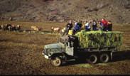
48 Watchable Wildlife Opportunities The White Pass Scenic Byway is the gateway to a variety of wildlife habitats that support diverse and healthy wildlife populations. Several of the species that thrive in the corridor Rocky Mountain Elk, Bighorn Sheep, Mountain Goat, Bald Eagle, and Salmon are popular species for wildlife watching, and are relatively abundant in the corridor. A wildlife experience of any one of these high profile species would be the highlight of a trip for many visitors. There are protected areas of wildlife habitat and developed sites for wildlife watching throughout the corridor, from the Cowlitz Wildlife Area and Swofford Pond in the Lakes District, to the Oak Creek Wildlife Area at the east end of the corridor. The byway is also one leg of the Southwest Washington Birding Trail, and is a popular destination for birders. The Oak Creek Wildlife Area is a good place to check off Lewis or Whiteheaded woodpeckers on your life list. During the wintertime when they are providing supplemental feedings, the Oak Creek Wildlife Area is a spectacular location for viewing Rocky Mountain elk. With advance reservations visitors can ride one of the hay trucks and help out with the daily feeding for hundreds of elk. Oak Creek typically hosts over 100,000 visitors each winter to view the elk feedings. Without exploring any of the other resources of the byway, a wildlife watching trip though the corridor could support an itinerary of several days. Corridor Management Plan 2-19
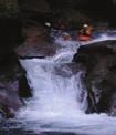
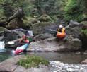
49 Mountain, River and Lake Recreation World-class outdoor recreation opportunities are available throughout the corridor. Visitors can fish for salmon, trout, kokanee and steelhead; hike easy day trails or set off on extended wilderness adventures; ride through great horse country; whitewater raft down the Tieton River; ski at the White Pass Ski Resort, or explore backcountry skiing beyond the lift lines; or snowmobile on hundreds of miles of trails. On the western end of the corridor, the Cowlitz River is a well-known sport fishing destination, with abundant salmon and steelhead. The large lakes impounded behind the dams developed for the Tacoma Power project and Lewis County PUD Riffe Lake, Mayfield Lake and Lake Scanewa, have become very popular recreation destinations. The power companies have developed high quality parks with camping and lake access, and Washington State Park s Ike Kinswa Park is located on Mayfield Lake. These parks provide boat access, swimming beaches and hundreds of campsites for water-based recreation. Closer to White Pass, the Gifford Pinchot National Forest provides camping opportunities and trailheads into the backcountry. Also in this area Mount Rainier National Park and Mount St. Helens National Volcanic Monument are only short side trips away. For experienced backcountry travelers, the congressionally designated Goat Rocks Wilderness Area, William O. Douglas Wilderness Area, Tatoosh Wilderness Area and Glacier View Wilderness Area are nearby. Together, theses wilderness areas provide 300,000 acres of primitive and undeveloped mountain landscapes for exploration and adventure. White Pass includes a developed ski area, as well as easy access to high country lakes near the highway and trailheads that take off from the pass into the high country. The Pacific Crest National Scenic Trail crosses the highway here, and there are numerous other trailheads for hikers and horseback riders. Every fall the Rimrock Lake reservoir on the Tieton River is drawn down to provide storage volume for winter floods. During this time, often lasting several weeks, the Tieton becomes one of the most popular river rafting destinations in the state, attracting thousands of rafters. Rimrock and Clear lakes are high elevation boating and fishing destinations White Pass Scenic Byway
50 On the east side of the pass the Okanogan-Wenatchee National Forest operates campgrounds and trailheads all along the corridor, with riverside camping and access to the eastern cascades backcountry. Fishing is popular in the fast waters of the Tieton, and the Oak Creek Wildlife Area protects cliffs that are both wildlife habitat and popular rock climbing areas. Corridor Management Plan 2-21
51 Mount Rainier, Mount St. Helens and Mount Adams Volcanic Region Many visitors to the byway come to the region to experience either Mount Rainier, Mount St. Helens, or both. Mt Rainier, the second highest peak in the contiguous 48 states, rises about nine miles north of Packwood. Designated America s fifth national park in 1899, Mount Rainier currently hosts approximately one million visitors per year. Many visitors to the park include at least a portion of the byway in their itinerary, either coming to explore the byway itself or as part of one of the many driving loops that include one of the mountains and the byway. Mount St. Helens, south of Morton, erupted in 1980 and currently is the most dramatic example of active volcanic activity in the continental United States. The blast zone is a world-renowned area of scientific research into the regeneration of living systems following volcanic disturbance. Most international visitors to the byway are primarily visiting Mount Rainier or Mount St. Helens, and find the more remote, wild character preferable to the more developed gateway areas as a base camp. More adventurous travelers will include a visit to Mount Adams the least developed of the three volcanoes in the corridor. With no visitor centers or paved access roads, Mount Adams country is a true backcountry experience, with stunning alpine lakes, plentiful wildlife, and opportunities for long or short hikes. Even for byway travelers who don t take advantage of the short side trips to visit one of the volcanoes, the story of the volcanic region is an important part of the travel experience, and volcanic geology is prominent throughout the corridor. Especially on the more arid east side of the byway, exposed volcanic geology is everywhere you turn, with different geologic layers and formations creating a distinctive visual character to the landscape White Pass Scenic Byway
52 Resources Overview Corridor Management Plan 2-23
53 Salkum Plateau Small-scale agriculture, rural residential communities, and rolling hills are typical of the west end of the byway. Views of all three of the corridor s volcanoes can be seen from this section of roadway the only place on the byway where all three mountains can be seen at once. A short side-trip from the byway takes visitors to Cowlitz River salmon and trout hatcheries. The Cowlitz salmon hatchery is the largest in Washington State, and has a very good self-guided tour through the facility. Lewis and Clark State Park has easy access to a protected stand of old growth forest habitat, and also includes one of the corridor s most significant historic buildings, the 1850 John R. Jackson courthouse. Cowlitz River Fishing The Cowlitz River attracts visitors for fishing from throughout the west coast. Including salmon, steelhead, and cutthroat trout fisheries, the Cowlitz has yearround fishing opportunities. Visitors enjoy the spectacular fishing and also the beautiful setting of the river, with abundant wildlife, healthy forests, and majestic peaks rising above the river. Cowlitz Salmon Hatchery The hatchery produces over 13 million salmon each year. Returning salmon are collected, their eggs are harvested, then they are raised in a series of pens until they are strong enough for release and their journey to the Pacific. The Cowlitz Salmon Hatchery is an important producer for the sport fishing industry for both the Cowlitz and Columbia Rivers. Lewis and Clark State Park With facilities built by the Civilian Conservation Corps, Lewis and Clark State Park preserves a large tract of lowland old growth forest. Eight miles of hiking trails in the park include an interpretive loop through the heart of the old growth forest stand. The park also manages the nearby John R. Jackson Courthouse. Built in 1845, it is the first pioneer house built west of the Cascades and north of the Columbia River White Pass Scenic Byway
54 Lakes The Lakes District includes one of the most dramatic driving moments on the corridor turning the corner to the Mayfield Lake causeway, with the clear water of the lake surrounding the road and the green backdrop of the forested shoreline. Recreation facilities on Mayfield and Riffe Lakes are some of the busiest in the corridor, including camping, fishing, wildlife watching and hiking. Approaching Mossyrock, the display gardens and flower fields of DeGoede s Bulb Farm are a major seasonal destination in the springtime, but offer something for visitors to see throughout the growing season. The community of Mossyrock provides small-town character and services for visitors. Mayfield Lake Formed by the Mayfield Dam on the Cowlitz River, the 13 mile long Mayfield Lake is the setting for camping and recreational facilities. Mayfield Lake Park and Ike Kinswa State Park, both operated by Tacoma Power, include camping facilities, boat ramps, and day use facilities. The Cowlitz Wildlife Area, also managed by Tacoma Power, provides wildlife viewing opportunities for visitors to both Mayfield Lake and Riffe Lake. Riffe Lake Formed by the Barrier Dam, the tallest dam in Washington State, Riffe Lake winds for over 20 miles through steep walled canyons. Mossyrock Park provides recreational facilities on the west end of the lake, with Taidnapam Park on the east end. Two viewpoints on the highway the barrier dam overlook and Riffe Lake overlook are important visitor facilities in this area. DeGoede s Bulb Farm A major attraction in spring when the bulb fields are in bloom, DeGoede s also offers a year-round display garden along with classes and other visitor activities. Hopkins Hill Viewpoint A short drive to an elevated viewpoint provides a view straight into Mount St. Helens blast crater. Popular with travelers, this viewpoint is one of the best spots to see Mount St. Helens when volcanic activity closes down facilities closer to the mountain. Corridor Management Plan 2-25


55 Morton The highway turns north away from the Cowlitz River Valley for a short while as it heads towards Morton, a major byway community and an intersection with one of the northern routes to Mount Rainier National Park. Morton provides a range of visitor services, including grocery stores, lodging, laundry, and the corridor s only hospital, along with a charming historic downtown with dining and shopping. Morton has a thriving timber processing industry, with two active mills, and is the home of the annual logger s jamboree. Morton Depot Morton s historic depot has been relocated, and is being developed as a visitor center, museum, and hub for revitalized excursion train service. The historic building is architecturally distinguished, and anchors the community s revitalized downtown. Loggers Jubilee The region s largest celebration of logging skills and culture takes place every August in Morton. Communities for miles around are packed as visitors come to Morton to watch the smalltown parade, lawnmower races, and of course the logging skills competitions White Pass Scenic Byway
56 Big Bottom Valley After Morton, the highway swings south again to the upper end of Riffe Lake and the Cowlitz River Valley. The broad lowland floodplain is surrounded by forested foothills, and with occasional views to the big volcanoes. This district includes several more lakeside parks with boating, camping and fishing. Randle, the largest community in the district, is the turning-off point for the Mount St. Helens National Volcanic Monument and Columbia River Gorge. The valley bottom is prime elk habitat especially in the winter months as elk come down from the highlands and they can frequently be seen in large herds in the valley s extensive grassland grazing areas. Side roads from the highway in this district provide access to the rich recreational opportunities in the Gifford Pinchot National Forest, including hiking trails, scenic backcountry driving routes, and mountain biking sites. Forest Recreation Hiking and mountain biking in the Gifford Pinchot National Forest attract thousands of visitors each year to the byway. From easy family hikes to challenging backcountry singletracks, there are dozens of options with access from this section of the byway. Windy Ridge Viewpoint Visitors to Windy Ridge are right in the middle of the blast zone, surrounded by views of pumice plains and Spirit Lake, with the volcano itself rising only four miles away. Mount Adams views Turning the corner into Randle, Mount Adams comes into view, rising high above the nearer foothills. This is the best view from the byway of Mount Adams, the easternmost of the region s three volcanoes. Cowlitz Valley Elk Habitat The Big Bottom Valley is at its best here a wide river plain with the Cowlitz winding through rich farmland and riparian areas. Fields in this area are often filled with elk, quietly grazing in the bottomland fields. Corridor Management Plan 2-27

57 Alpine Pass The scenic crown of the White Pass Scenic Byway, this section climbs steeply towards the pass with outstanding views into the Goat Rocks wilderness and Mount Rainier National Park. Scenic pullouts provide views to Mount Rainier and other alpine peaks, along with steep-walled canyons, tall waterfalls, and unique volcanic geological formations. Wilderness Trails Trailheads along this section of the byway provide access to the Tatoosh, William O. Douglas, and Goat Rocks wilderness areas hundreds of thousands of acres of spectacular sub-alpine terrain. Several short hikes from byway trailheads provide access to alpine lakes and mountain vistas without the commitment of a full day (or multi-day) hike. White Pass A major winter ski destination, White Pass also offers some hiking in the summer, and a pleasant stop along the roadway in a high mountain environment. Mount Rainier & Goat Rocks Viewpoint A jaw-dropping view of Mount Rainier, and the complex subalpine area of the Goat Rocks Wilderness. Palisades Viewpoint This newly-renovated viewpoint offers views of dramatic volcanic palisade rock formations, forming the backdrop of a steep valley White Pass Scenic Byway
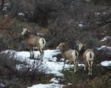
58 Rimrock As the byway crosses over White Pass and begins winding down the east slope of the Cascades, it passes Rimrock Lake, a large reservoir created by a dam on the Tieton River. This section of the byway includes beautiful ponderosa pine forests and scenic vistas over the lake. In the fall, larches on the surrounding hillsides turn a clear yellow, celebrating the season before winter snowfall. Trails and camping areas are located throughout the Rimrock area. Rimrock Lake The highest elevation large lake along the byway, Rimrock Lake offers recreation, camping, and beautiful views to surrounding foothills. Rainbow Trout and Kokanee are available for anglers. Clear Lake Located near Rimrock Lake, the smaller Clear Lake is another popular fishing destination and also a good watchable wildlife location. Like Rimrock, Clear Lake is a good place to view bald eagles, osprey, and elk. Corridor Management Plan 2-29
59 Tieton Riverside The byway follows the Tieton River, a sparkling alpine river in a relatively narrow canyon. Along with the river, there is evidence of volcanic geology throughout this section colonnades, pillow lava, and other formations, all exposed in the more arid eastside environment. There are also frequent wildlife sightings in this section of the byway. River recreation sites are also scattered along the highway in this area for camping, water access, and day use. Tieton River Rafting As part of annual management of lake levels in the Rimrock Lake reservoir, water is released into the Tieton River over several weeks each fall, providing a great river rafting opportunity. Outfitters and self-guided rafters flock to the river, filling campgrounds and bouncing down the rapids. Tieton River Recreation When the river isn t filled with rafts, it s a popular destination for fishing, camping, and wildlife viewing. A small, fast-flowing river in a scenic high-walled canyon, the Tieton is a favorite place for all sorts of water-related recreation. Tieton River Canyon Geology Without the heavier vegetation of the west slopes, the volcanic geology of the region is exposed for dramatic views from the highway. Steep canyon walls show the contorted shapes and complex bedding of thousands of years of volcanic deposition White Pass Scenic Byway
60 Oak Creek Extending from the highlands of the eastern White Pass area to the confluence of the Tieton and Naches Rivers, the Oak Creek area is a narrow riparian canyon defined by steep rock walls. The volcanic origins of the roadside cliffs display the intricate patterns of lava deposition and cooling, support raptor nests in the spring, and are a rock climbing destination when not closed during nesting season. The Tieton River in this section is a popular for fishing, and the Oregon White Oak ecosystem provides habitat for a wide variety of animals, from songbirds to bighorn sheep. Oak Creek Wildlife Area Wildlife Watching One of the best locations for watching elk in the United States, Oak Creek also provides opportunities to see other wildlife throughout the year. In winter elk congregate at the Oak Creek feeding station by the hundreds. Visitors see the elk up close as the jostle for position at the hay drop, and interact in a large herd. Other wildlife viewing includes bighorn sheep, woodpeckers, raptors, and a variety of songbirds. Oak Creek Natural Habitats Oak Creek is a great wildlife location because of its high quality habitat. From the narrow riparian zone around the Tieton River to Oregon White Oak savannah habitat, and higher elevation steppe country, the Oak Creek wildlife area includes beautiful, diverse, habitat areas that offer visitors an experience of an unusually rich natural landscape. Tieton River Rock Climbing Besides its scenic value, the dramatic volcanic geology of the Tieton River is also one of Washington State s better rock climbing destinations. Climbers come from throughout Oregon and Washington to test themselves on over 300 different routes. Corridor Management Plan 2-31

61 Naches Valley Following the Naches River from its confluence with the Tieton, the byway winds through fruit orchards and rural residential areas to the small town of Naches. Inside Naches the highway is lined with fresh fruit stands selling local produce, and a historic art deco gas station restored as a visitor center marks the entry to downtown. Oak Creek Wildlife Area Bighorn Sheep Feeding Station Although Bighorn Sheep are not as numerous as the Rocky Mountain Elk fed at the main location for the Oak Creek Wildlife Area, they can be seen throughout the year at a small feeding station set at the base of a dramatic cliff on Mount Clemans. City of Naches Visitor Information Building A preserved art-deco gas station, the Naches visitor information building is a fun, graceful landmark for the town of Naches. The Naches depot, adjacent to the historic gas station will be the hub of visitor activities for this section of the byway White Pass Scenic Byway
62 Chapter 3 DESIGN GUIDELINES Corridor Management Plan 3-
63 Purpose and Intent Traveling a scenic byway is intended to be a different experience than traveling regular roads. Roadway elements should support that experience and contribute to making the road distinctive and memorable. For the most part, the quality of the travel experience depends on corridor resources the landscapes and communities that are the context for the byway. However, appropriate design of scenic byway features can enhance the travel experience by drawing travelers attention to corridor resources, enhancing their understanding of the landscape they are passing through, and reinforcing the byway theme with their design character. Design Guidelines are a tool for consistent development of capital improvements along the roadway. The primary focus of the design guidelines is on amenities for recreational travelers. However, selected roadway, roadside, and maintenance elements are also included because of their importance to the traveler experience. These guidelines are intended to be used for all byway-related roadside facilities throughout the corridor. As guidelines they are intended to be flexible, and allow reasonable modification in the development of individual sites. In all cases, the guidelines are focused on providing a safe and convenient experience for travelers. 3- White Pass Scenic Byway
64 Goals The goals for the design guidelines are to: Improve the visitor experience of the highway by enhancing its scenic character Improve the aesthetic and design consistency of byway capital improvements Improve wayfinding and decision-making for travelers by providing them with a recognizable image for byway-related sites and features Improve the traveler experience and support local tourism businesses by improving signing for travel-related businesses (Traveler-Oriented Destination Signs) Streamline the design and approval process through the development of standard designs for common byway-related features Corridor Management Plan 3-3

65 3- White Pass Scenic Byway
66 Using the Guidelines The guidelines document describes: the overall byway theme general considerations for use of materials aesthetic guidelines for commonly used byway elements overviews of considerations for major roadway projects and corridor-wide traveler amenities These guidelines are a starting point for planning and designing visitor-oriented capital improvement projects along the byway. It is important to remember that the guidelines are not a replacement for coordination with the White Pass Scenic Byway management group and other stakeholder agencies. Related design resources, including details developed for other byway projects, specifications, and material sources, may be available. You are encouraged to contact the White Pass Scenic Byway management group early in the design and planning process to identify what resources may be applicable to your project. Corridor Management Plan 3-
67 Guiding Theme The overall byway themes focus on watchable wildlife and outdoor recreation. The visual/aesthetic theme for the design guidelines is intended to be compatible with those themes, and with the aesthetic character of the byway s resources. Many visitors to the byway are also visiting either Mount Rainier National Park, the Mount St. Helens National Volcanic Monument, or both. Mount Rainier National Park includes nationally significant examples of rustic architecture, characterized by overscaled timber and stone construction, visible joining, and rustic detailing. Facilities at Mount St. Helens were developed more recently and display a more contemporary aesthetic approach, however the facilities were developed at very high standards for materials and finishes. They provide valuable examples for interpreting rustic design in a contemporary project. The design theme and materials choices for the White Pass Scenic Byway are inspired by the quality and character of the two iconic public landscapes in the region. Generally the theme is consistent with the rustic Cascadian style typical of WPA and CCC-era public construction. The style is typified by the use of native materials, overscaled proportions, and visible joinery. Local examples of design elements consistent with this theme include the monumental entry portals to Mount Rainier National Park, and the recent improvements to the Mather Memorial Parkway section of the Chinook Scenic Byway. 3- White Pass Scenic Byway
68 Guidelines Materials The materials for built elements along the byway should be durable and of high quality. Locally-sourced materials are preferred over imported materials. Where design elements are located near the operational zone of a roadway or parking area, or are in a location where visitors might have direct contact with them, safety and durability should be considered in both materials choices and construction methods. Corridor Management Plan 3-
69 Stone Stone for design elements should be locally-sourced river rock, generally installed as a veneer over a poured concrete or other masonry core. In general, the veneer stone should vary in size, with larger stones used near the bottom of the installation and smaller stones at the top. Smaller filler stones should be used between larger stones to minimize mortar joints. Wood Wood members should generally be large scale and rough sawn. Finishes should be stain or clear, rather than paint. Where wood is exposed to weather western red cedar is preferred. Treated wood may also be appropriate for applications that are exposed to weather, however treated wood with visible knife cuts should not be used. Where wood is protected under roofs or other shelters Douglas fir, ponderosa pine, and hemlock are also appropriate. Metal caps may be appropriate where end grain is exposed to the weather, or where they are aesthetically consistent and would protect wood from weathering. Simple joinery is appropriate, including rough notches and exposed hardware. Decorative metal fasteners, including straps, exposed bolts, plates, braces, etc. are appropriate, and should be designed to enhance the proportions and rhythm of the structure. Metal hardware should be painted or powder-coated rather than galvanized. Pre-fabricated galvanized hardware, for example joist hangers and nailing plates, should not be used where they will be prominent to viewers. Concrete Visible concrete should be avoided for use in vertical elements. Concrete is preferred for curbing over asphalt, and is preferred for paving pedestrian areas. Simple paving treatments are preferred for byway facilities. Stained or patterned concrete should be avoided. Asphalt Asphalt is the preferred paving surface for vehicle areas. Asphalt may also be used for pedestrian areas. Asphalt should be avoided for curbs. 3- White Pass Scenic Byway
70 Guidelines Gateway Signs Welcome to the White Pass Scenic Byway and its friendly communities. You can t welcome every recreational traveler personally, so Gateway Signs serve that function, letting travelers know where they are and that they re welcome. The character of gateways signs also tells travelers a little bit about the byway what kind of experience they might expect, and that locals are committed to providing a good travel experience. The proposed gateway signs for the corridor would be constructed of stone and wood, with a similar look to the historic CCC structures familiar to visitors from their experiences at favorite National Park, State Park and National Forest sites. Four types of gateway signing are included in the guidelines. Corridor entry gateways are located at either end of the byway. Corridor intersection gateways are located where major connecting routes meet the byway. Major community gateways announce the bigger towns on the highway, and minor community gateways announce the smaller towns. Centralia Elbe 706 Ashford MT RAINIER NATIONAL PARK 123 WENATCHEE NATIONAL FOREST Rimrock 410 Naches Chehalis Mary's Corner Mossyrock 7 Morton Randle Skate Creek Road Packwood White Pass Yakima Salkum Glenoma GIFFORD PINCHOT NATIONAL FOREST Toledo MT ST HELENS NATIONAL MONUMENT YAKAMA INDIAN RESERVATION Corridor Entry Gateways Corridor Intersection Gateways Major Community Gateways Minor Community Gateways Corridor Management Plan 3-
71 WHITE PASS Scenic Byway WHITE PASS SCENIC BYWAY Corridor Gateways Corridor Entry Gateways will be located at either end of the byway, one near Mary s Corner and one near Naches. These large signs mark the byway, and let travelers know they ve come to an area where they can expect outstanding scenery and recreational opportunities White Pass Scenic Byway
72 Packwood Mt. Rainier Yakima WHITE SCENIC PASS BYWAY Mossyrock Interstate 5 Corridor Intersection Gateways Corridor Intersection Gateways will be located at major intersections with the byway, for SR 410, SR 123, Skate Creek Road, the SR 131, and SR 7. These signs welcome travelers to the byway and provide directional information. Corridor Management Plan 3-11
73 MORTON Welcome To home of the Logger's Jubilee WHITE SCENIC PASS BYWAY Major Community Gateways Major Community Gateways will be located both east and west of the five major byway towns Mossyrock, Morton, Randle, Packwood, and Naches. One sign is also located at White Pass, an important byway location. These signs will raise awareness of communities, and hopefully increase recreational traffic and tourism spending. Entry elements for individual communities along the byway may be located both east and west of the byway or at the major turn location for entering the community, as appropriate. Community gateways may be used to indicate services/amenities available as well as the community name White Pass Scenic Byway
74 Welcome To RIMROCK RETREAT Tieton River P aradise WHITE SCENIC PASS BYWAY Minor Community Gateways Minor Community Gateways will be located both east and west of the byway s smaller towns Salkum, Glenoma, and Rimrock Retreat. Note: this sign type may also be used for other gateway locations if they need to be placed inside the clear zone. The sizing of individual members and either drilling or mounting on a breakaway pedestal as per WSDOT specifications. Corridor Management Plan 3-13
75 Guidelines Site and Information Signs Site signs are much more varied than gateway signs, and the guidelines will need to be applied with more flexibility. Typically roadside features are signed twice an advance sign that provides early warning, then an intersection or entry sign that prompts action. For most locations, it is anticipated that advance warning signs would follow MUTCD standards without modification, and intersection or entry signs would be consistent with the design guidelines. Any signs to be mounted inside the clear zone need to be consistent with WSDOT requirements for traveler safety. Typically, the wood-base options for site signs can be designed to meet breakaway and mass requirements. Corridor-specific guidelines for traveler services signs (TODS) are intended to be implemented in coordination with a phase-out of current Motorist Information Signs in place on the byway. The traveler services signs would not include individual business names. Instead they would provide direction to generic tourist services, including food, lodging, retail areas, and others White Pass Scenic Byway
76 I C Palisades Viewpoint Palisades Viewpoint WHITE PASS WHITE PASS SCENIC BYWAY SCENIC BYWAY Dog Lake CAMPGROUND Palisades WENATCHEE Viewpoint NATIONAL FOREST WHITE PASS WHITE PASS Scenic Byway WHITE S C E N PASS B Y W A Y Palisades Viewpoint WHITE PASS SCENIC BYWAY SCENIC BYWAY Site Signs Site Signs will be used to locate access to individual sites, helping travelers understand where to turn or stop. For example, these signs will be used at the entries of viewpoints, trailheads or other roadside activity areas. The stone base design is only appropriate outside of the clear zone. The wood base can be designed to meet safety requirements for placement in the clear zone. A modified US Forest Service pedestal base maintains the easily recognizable Forest Service signs, but is consistent with the byway sign family. Corridor Management Plan 3-15
77 Taidnapam Park Peterman Hill WHITE SCENIC PASS BYWAY Recreation Opportunity Signs Recreation Opportunity Signs will provide direction to recreational sites in the corridor. These signs will provide consistency for recreation sites in the corridor, and emphasize major destinations. Recreation activity logos will be used widely to improve information on available activities, and site names will also be included to ease coordination with byway maps or brochures White Pass Scenic Byway
78 Historic Downtown Information Center Lodging Dining Services WHITE SCENIC PASS BYWAY Traveler Services Signs Traveler Services Signs will provide direction to common support services for travelers gas, food, lodging, restrooms, information, and other practical needs. These signs will be located on both sides of major corridor communities, and also throughout the corridor where these services are offered. Communities and businesses will have input on the content of these signs, which are intended to support travel-related businesses in corridor communities. Corridor Management Plan 3-17
79 Guidelines Sign Panels Information is critical to byway travelers especially first time visitors and consistency helps travelers recognize and understand wayfinding signs. In general, although sign supports for certain kinds of signs are unique to the byway, sign panels follow WSDOT sign manual, MUTCD, and individual agency standards. The significant exception is the implementation of traveler services signs along the byway, which vary somewhat from the standard WSDOT Traveler Oriented Directional Sign or Motorist Information Signs, although they generally comply with MUTCD standards White Pass Scenic Byway
80 Land Management Agency Byway Signs Agency sign panel design guidelines, including shape, color, text, and other design features are appropriate for use where the agency would prefer to maintain their own graphic style. Where possible, sign supports should follow the byway guidelines to provide consistency throughout the corridor. Maintaining the look and feel of agency sign graphics is valuable to byway travelers, who are generally familiar with agency signs and have developed expectations for the type and quality of services provided by different agencies. Scenic Byway Logos and Shield Use The White Pass Scenic Byway shield is a distinct visual element intended to identify byway-related facilities. It includes a unique shape, a specific type font, and the byway logo. It can be used at different scales, either as the primary sign, or as a small badge attached to signs or sign supports to indicate participation in the byway. The White Pass Scenic Byway logo may also be used as an identifying element on site signs. The shield is more visible at higher speeds, while the logo has more of an identifying image for the byway. Community gateway signs share a common size and shape, however within that size and shape they are intended to be unique to each community, and designed by the community. Materials Materials for sign panels should match their intended use, and be durable and colorfast. Wood signs may be used if there is a committed maintenance partner. The current US Forest Service synthetic sign fabrication material is an appropriate choice for large signs, including byway and community gateways. Standard paint or reflective sheeting on metal substrate are appropriate for many roadway-related signs. If signs are not two-sided, the back side should be painted a neutral brown to minimize visual intrusion. Corridor Management Plan 3-19
81 Maintenance Maintenance for signs located in byway sites is the responsibility of the underlying land management agency unless a specific maintenance agreement is developed. Maintenance should be included in any partnership discussions during the project development process. Maintenance for non-standard signs in the right of way is the responsibility of the byway organization. Prior to installation of any non-standard signs WSDOT will require a maintenance agreement clearly describing the appropriate responsibilities for landscape care (if necessary), repairs necessary due to normal wear and tear, and a plan for responding to unusual maintenance needs (for example major vandalism or other damage). Traveler Services Signs Traveler services signs are intended to promote local communities and businesses, and assist travelers in finding necessary services. Current WSDOT Motorist Information Signs have not been widely used in the corridor, and are not providing effective traveler information. Community stakeholders and operators of travel-related businesses are interested in developing a system of traveler services signs that are based on categories of traveler needs, rather than names of individual businesses. Since they would not advertise individual businesses, the signs would also not require annual fees. Signs will use standard MUTCD layout, with white text on a blue field. Content for the panels will be proposed by byway stakeholders, with final approval by WSDOT. Where signs serve incorporated communities, requests for panel content is the responsibility of the community, and must have city council approval. In unincorporated areas of the two counties, requests for panel content is the responsibility of the county, and must have approval of the county commission. Cities and counties are encouraged to consult with the scenic byway management committee prior to developing requests for signs. Individual businesses are eligible for signing where they are not adequately served by a community sign. Requests for signs serving individual businesses should be made first to the appropriate city or county, who will finalize the request to WSDOT. Cities and counties are encouraged to investigate whether there are other eligible businesses served 3-20 White Pass Scenic Byway
82 by the same intersection prior to developing a request to WSDOT. Where trailblazer signs are necessary to direct a traveler to the service after they have left the highway, these signs are the responsibility of the appropriate city or county. Where trailblazer signs are necessary in WSDOT s judgement, requests for traveler information signs will not be approved prior to completion of an interlocal agreement that trailblazer signs will be provided. Local jurisdictions may require individual businesses to contribute to funding trailblazer signs outside of the highway right of way. Supports for travel information signs are shown above, however they may be modified or replaced with standard metal supports where they only support one or two signs, or where there is no committed maintenance partner. For this category of byway signs, WSDOT will be responsible for maintaining sign panels, and local partners will be responsible for non-standard supports. Corridor Management Plan 3-21
83 Guidelines Site Development Design Guidelines will provide continuity and consistency to the capital improvement projects along the byway. Consistency in design benefits travelers by providing a familiar image for byway sites, and promotes quality design throughout the byway. As an added benefit, design guidelines can simplify the design and approvals process, saving money and time. Individual sites should be designed with some variation and individual character, so the design guidelines allow flexibility based on site needs. Where consistency is strongly recommended for gateway sign supports and visitor information signs, individual site features can show more diversity, maintaining general design and materials similarity without being identical from one site to the next. As detailed designs are developed for individual sites, the plans and specifications will be useful resources for other projects developed along the byway White Pass Scenic Byway
84 WHITE PASS S C E N I C B Y W AY WHITE PASS WHITE PASS S C E N I C B Y W AY S C E N I C B Y W AY WHITE PASS WHITE PASS S C E N I C B Y W AY S C E N I C B Y W AY Information and Interpretive Kiosks Kiosks provide opportunities for travel information or interpretive displays. They are large site features often easily seen from the roadway and will help to communicate the significance of a site to the traveler Corridor Management Plan 3-23
85 Site Information and Interpretive Signs Site signs provide interpretive or travel information. These freestanding sign supports are used instead of, or in some cases in addition to kiosks White Pass Scenic Byway
86 Pedestrian Railings and Barrier Walls Pedestrian railings and barrier walls are common site features that enhance public safety, protect sensitive resources from disturbance, and improve the aesthetics of visitor sites. A variety of design options can be used that combine native wood with river rock, compatible with other site features. Corridor Management Plan 3-25
87 Guidelines Highway Construction and Maintenance The section of US 12 in the area of the White Pass Scenic Byway is a highway of statewide significance that also includes a mountain pass. Snow clearing and storage in the winter months is a continuous challenge, and small snow slides that temporarily close the road are a regular occurrence. There are several locations as the road nears White Pass where rockfall is a significant safety and maintenance concern year round. Safety and operations are the highest priority for the roadway. However, supporting recreational travelers and the interests of local communities for tourism development are also important functions for the roadway. Almost all aspects of the roadway s development and management have aesthetic implications, and may also affect recreational access and opportunities. Highway improvement projects, major maintenance, and selected routine maintenance activities (particularly vegetation management, rockfall and snow collection and storage, and maintenance of highway appurtenances like barriers) should be developed in consultation with byway stakeholders, and include aesthetic and recreational considerations White Pass Scenic Byway
88 General Highway Construction Roadway alignment, profile, section, and roadside design all provide opportunities to gracefully integrate the highway into the surrounding landscape. Highway improvements often provide opportunities to enhance views, and improve the travel experience. Careful planning can also reduce the impacts of highway construction and operations on byway resources. Design opportunities will vary with specific projects, however the scenic and recreational character of the roadway should be considered for most projects developed for the highway. In general, the following guidelines are recommended: Capital and major maintenance projects should include a collaborative design review process including appropriate byway stakeholders and WSDOT State Scenic Byway Coordinator. Formation of project-specific advisory committees should occur early in the planning process, and should be maintained through final design. WSDOT project teams should include project staff with environmental and aesthetic expertise. General principles of context-sensitive solutions should be applied as possible. Projects in other areas of the state and along other scenic byways provide valuable examples of context-sensitive solutions that may be applicable to US 12 projects. Aesthetic enhancements may be opportunities for cost sharing between byway stakeholders, or might be eligible for special grant funding. Aesthetic enhancements should not be excluded due to cost prior to investigating alternate funding strategies. Barriers In general, w-beam guardrails are acceptable for most corridor locations, however other options for barriers more compatible with the scenic environment should be considered as part of the project development process. Weathering steel guardrails, cable barriers, and steel-backed wood guardrails might be appropriate in specific locations. Barriers damaged due to accident or during maintenance/snow removal activities should be replaced as part of regular maintenance activities. Concrete barriers, including jersey barriers and single-slope concrete barriers generally block views and are more visually prominent than guardrails, and are not preferred. Corridor Management Plan 3-27
89 Aesthetic barriers, for example steel-backed wood guardrails or stone veneer walls, may be appropriate for low-speed circulation areas inside byway-related sites, and should be considered on a site-by-site basis. Rockfall Rockfall protection technology is continuously evolving, and solutions for preventing rockfall and protecting the roadway are extremely site specific. Rockfall solutions are often visually prominent, whether they include scaling to expose new rock or structural catchments, and can have a significant influence on highway aesthetics. Because of the different conditions that apply to different rockfall locations and continuing improvements to rockfall catchments, specific design guidelines are not appropriate. However, aesthetics are appropriate for consideration as part of rockfall management projects. In general, the following guidelines are recommended: All rockfall projects, including both capital projects and major maintenance, should include aesthetic considerations in the selection of best technology. Similar to other highway improvement projects, project teams should include representatives from the byway, US Forest Service, and WSDOT landscape architects. Aesthetic benefits should be included as one of the evaluation criteria for projects. Mitigation, including techniques like weathering stain, materials selection, and color selection for catchment elements, should be considered where appropriate. Pullouts Pullouts for scenic views or interpretation are highly valued by recreational travelers, and an important component of the byway. Any location where vehicles are entering and leaving traffic on an access-controlled highway is a concern, and because scenic locations are often in steeper or more difficult terrain, viewpoints can be challenging from a safety perspective. The following guidelines are recommended for pullouts: Separation between the highway and parking areas is preferred, generally with a landscaped buffer. If the buffer is not adequate to provide a clear zone, then a guardrail may be used in combination with a buffer. Single two-way or separate oneway entries and exits are both appropriate depending on the location White Pass Scenic Byway
90 Where separated pullouts are not feasible or appropriate, parking and any internal vehicle circulation should be outside of the clear zone. Appropriate sight distance should be available for any pullout. Where good sight distance is not available improvements including grading of eyebrow hillsides, or vegetation management should be considered if they could be used to improve sight distance to meet standards. Acceleration and deceleration lanes are not necessary where appropriate sight distance is provided and the other roadway characteristics (accident history, speed, etc.) do not indicate that entry to the roadway from the pullout would be unsafe. Access to pullouts from the opposing lane require site-specific design review. Turn pockets are preferred, but not required, where sight distance, traffic volumes, and typical speed are appropriate. Where entry and exit from a pullout would not be safe from the opposing lane, the pullout may still be developed, but not signed for opposing traffic. Vegetation Management Roadside vegetation is an important contributor to the aesthetic character of the highway. Every effort should be made to preserve mature trees and healthy vegetation communities in the right-of-way. Strategies may include selective pruning rather than removal of an entire tree, use of guardrails to protect trees in the clear zone, and selection of locations for wasting materials (snow and rock) to avoid damage to roadside vegetation. Where viewpoints are being considered, vegetation management plans should be developed to ensure that scenic views are sustainable. Selective tree removal is often necessary to maintain views. Where trees on adjacent ownerships may grow to block views over time, a maintenance agreement with the propriety owner should be finalized prior to capital expenditure. Corridor Management Plan 3-29
91 The Naches Depot 3-30 White Pass Scenic Byway
92 Chapter 4 VISITOR SERVICES Corridor Management Plan 4-
93 A Pleasant Trip The byway provides travelers with exceptional opportunities for recreational driving, learning, and nature-based recreation. These are the reasons people visit the byway. However, a pleasant trip on the byway also requires the visitor services that meet the practical needs of travelers as they spend their days on the road. Food, lodging, restrooms, and traveler information can be as important as views, trails, and elk to watch. Resources are what the trip is about, but practicalities make it easy and enjoyable. Food and lodging are available at a variety of private businesses and public campgrounds throughout the corridor. The byway plan includes recommendations for improving the availability of traveler information and restrooms to complement private businesses in the local communities. A key part of a successful trip is that visitors feel welcome, and that the services they need are provided with a welcoming attitude. Community facilities are often best at this, where a store clerk or visitor center staffer can provide information along with a friendly, personal connection. 4- White Pass Scenic Byway
94 Traveler Information System Traveler information kiosks, brochures, maps, or a friendly staffer is very important to recreational travelers. It also provides residents with the opportunity to influence visitors travel decisions. Research by Washington State Tourism shows that a surprising number of recreational travelers have changed their itineraries even adding extra days to their trip because of travel information they have received while on their trip. Currently Destination Packwood and the City of Morton operate staffed visitor centers. Travel and recreation information is also available at the Cowlitz Valley Ranger Station in Randle, the Naches Ranger Station in Naches, and at the Ohanapecosh Ranger Station at Mount Rainier National Park. Unstaffed sites are located throughout the corridor in a few locations, including the intersection of I-5 and US 12, Mossyrock, Packwood and Naches. The Scenic Byway project is proposing several improvements to the travel information network along the byway, including both staffed and unstaffed sites. A byway-oriented information area is proposed for each of the major communities along the byway, along with selected byway-related sites where traveler information would be appropriate. Trip planning will also be supported by a byway website and tear-off maps/brochures for incorridor itinerary development. Corridor Management Plan 4-
95 Goals Develop traveler information web site to support trip planning. Develop tear-off maps /brochures to support in-corridor wayfinding and itineraries. Provide an unstaffed travel information display in each of the major communities using byway design guidelines and including scenic byway travel information. Supplement existing staffed information centers with outdoor displays to serve visitors outside of operating hours and in the off-season. Upgrade selected unstaffed information displays consistent with byway design guidelines, and improve information displays. Develop training materials and an outreach program to train retail and services staff in the corridor to provide effective travel information. Encourage local tourism contact staff from visitor center staffers to gas station clerks to consistently provide friendly hospitality and accurate information for visitors. 4-4 White Pass Scenic Byway
96 Information Site Standards Where possible, information areas should have a look and feel consistent with the byway design guidelines. A consistent image for traveler information areas will help visitors recognize information sites and encourage their use. Unstaffed information sites should provide safe access to and from the highway, and adequate public parking. The ability to accommodate RV s is strongly preferred. The site should feature a kiosk large enough to display two panels of information. Other site elements, including interpretive features, trash receptacles, and restrooms, may be appropriate, depending on partnership agreements for maintenance and operations. All information sites should have a designated site steward who can check for vandalism or damage at least weekly, and update information at least monthly through the travel season. Where possible, unstaffed information areas should be located adjacent to active businesses or other locations where the regular presence of people can deter vandalism. Staffed visitor centers should be signed on the byway, and provide effective trailblazer signing where necessary. Parking for several vehicles, including RV s, is preferred. All staffed visitor centers should provide public restroom facilities. Staffed visitor centers are also encouraged to develop unstaffed kiosks as supplemental information for hours when they are closed. Many forest service information centers include a covered vestibule that can provide 24-hour access to brochures and allow travelers to get out of the weather. Corridor Management Plan 4-5
97 Information Site Projects Centralia Elbe 706 Ashford MT RAINIER NATIONAL PARK 123 WENATCHEE NATIONAL FOREST Rimrock 410 Naches Chehalis Mary's Corner 7 Morton Randle Skate Creek Road Packwood White Pass Yakima Salkum Mossyrock Glenoma GIFFORD PINCHOT NATIONAL FOREST Toledo MT ST HELENS NATIONAL MONUMENT YAKAMA INDIAN RESERVATION Travel Information Sites Enhance existing unstaffed information kiosk New unstaffed information kiosk Enhance existing staffed visitor center 4- White Pass Scenic Byway


98 I-5 Intersection (KOA Campground) This popular information kiosk is operated by the owners of the adjacent KOA campground and service station. Staff at the service station are also trained to provide travel information, and stock both local and regional brochures. The location is signed as a travel information location both on I-5 and US 12. The kiosk relies on maps and displays provided by others, and is often outdated. This location offers a good opportunity to display byway information. The audience for the kiosk and information center includes travelers from both I-5 and US 12. The kiosk is privately owned. A future project could improve the aesthetics of the kiosk to be more consistent with byway design standards. Mossyrock Town Hall The Mossyrock Town Hall/ Community Hall is a natural town square for downtown Mossyrock. Currently, the city operates a small bulletin board with travel information. Enhancement of this site would include a new information kiosk located adjacent to the community hall parking area. The existing Mossyrock interpretive sign would also be relocated to this site. Morton Visitor Information Center The current staffed visitor information center (VIC) will remain as the primary information site in Morton. Signing would be improved to help visitors find the VIC, and the existing Morton heritage interpretive sign will be relocated here. Following its completion, the Morton depot is likely to become an important visitor destination, and provides a second opportunity to provide visitor information in the city. Project opportunities for the existing rest area include enhancement or replacement of the existing outdoor kiosk to meet byway design standards, and development of an enclosure for the outdoor portable restrooms. Corridor Management Plan 4-
99 Randle Intersection Visitor Information Site A new unstaffed visitor information site is proposed for the southeast corner of the intersection between US 12 and the 99/25 road. This is the primary route to Mount St. Helens and the Gorge from US 12, and also provides access to a wide variety of outdoor recreation in the Gifford Pinchot National Forest. This site would include parking, picnicking, a visitor information kiosk and vault toilet. This site is described in the Projects section of the corridor management plan. Cowlitz Valley Ranger Station, Randle US Forest Service ranger stations are important visitor information and service hubs. Recreational travelers generally have prior experience with ranger stations, and have an expectation that they will find reliable and complete recreational information as well as any necessary permits. Currently, the public information entry to the ranger station is nondescript, and minor design improvements could provide travelers with visual cues that would improve the prominence of the information area. Other opportunities to enhance the Randle ranger station include enhancement of an outdoor information kiosk, and provision of seasonal outdoor portable restrooms. If possible, the addition of a small entry vestibule with 24-hour access through the travel season would also be a benefit. WSDOT Rest Area The existing rest area would be enhanced with a new visitor information kiosk. This site has a very high traffic volume, providing a good opportunity to reach recreational travelers. 4- White Pass Scenic Byway

100 Packwood Visitor Information Center Currently, Packwood provides an unstaffed information kiosk in the parking lot of the Packwood Community Hall, and a staffed visitor center at the east end of town. Both of these facilities are operated by Destination Packwood. The current location of the VIC is inadequate too far from the community, not visible from the highway, and with poor parking circulation. The Packwood VIC would be relocated to a site in the town center, with better access and parking for visitors. Preferred sites include the Packwood Elementary building and the former Packwood Ranger Station. The existing information kiosk in the Community Hall parking lot would be upgraded with new information and a byway map. When the Packwood VIC finds a permanent home, it may be appropriate to develop a new exterior kiosk at that site with a byway look and feel, providing 24 hour information to supplement the staffed VIC. White Pass Passes are natural places for travelers to stop, stretch their legs, and read a sign. A new kiosk would be located at White Pass somewhere near the existing store/gas station, focused on summer season travelers. Corridor Management Plan 4-9


101 US 12/SR 410 Intersection A new information pullout with kiosk would orient byway travelers to both SR 410 and US 12, and let travelers know about the services available in nearby Naches. This site is described in more detail in the Projects section. Naches Depot The new (construction beginning 2006) Naches Depot will be a major information and interpretive facility for the byway. In partnership with the Washington Department of Wildlife and the US Forest Service, the depot is intended to be the initial contact point for many travelers visiting the Oak Creek Wildlife Area, and to provide a staging area for commercial raft trips on the Tieton River White Pass Scenic Byway
102 Restrooms Public restrooms are important to travelers, and several byway projects include new or upgraded restroom facilities. Standards typically call for spacing of miles between rest areas, or approximately one hour s drive. This spacing is too infrequent for recreational highways, where travelers are often stopping at corridor features and spending more time on the roadway. Restrooms are labor-intensive, and no new restrooms should be developed without management agreements for maintenance and operations. At several locations on the corridor, land management agencies are willing to allow development of new rest areas, but will require maintenance partnerships with local communities or the byway organization to support operations. In some more remote locations vandalism is a significant concern. Where long-term maintenance or vandalism of restroom facilities is a concern, portable restrooms should be considered as an interim strategy. Temporary placement of portable restrooms provides an opportunity to evaluate whether communities can maintain the resources for restroom maintenance, and whether vandalism will be a significant problem at new sites. Corridor Management Plan 4-11
103 Public Restrooms Centralia Chehalis Mary's Corner Elbe Morton Ashford 3. MT RAINIER NATIONAL PARK Randle Skate Creek Road Packwood 7. WENATCHEE NATIONAL FOREST White Pass Rimrock Naches 11. Yakima Salkum Mossyrock Glenoma 4. GIFFORD PINCHOT NATIONAL FOREST Toledo MT ST HELENS NATIONAL MONUMENT YAKAMA INDIAN RESERVATION Existing restrooms Enhance existing restrooms Proposed new restrooms 1. Mossyrock Dam Overlook 2. Morton Visitor Information Center 3. Randle Intersection Information Area* 4. Cowlitz Valley Ranger Station 5. WSDOT Rest Area 6. Packwood Visitor Information Center 7. Palisades overlook 8. Clear Creek Falls overlook 9. Wild Rose Day Use Area 10. Oak Creek Wildlife Area 11. Naches Depot 4-12 White Pass Scenic Byway
104 Chapter 5 SITE ENHANCEMENTS Corridor Management Plan 5-
105 Places for Activity and Experience Byway-related capital projects mostly located on or near the byway allow visitors to broaden their experience of the byway, and encourage them to spend more time or return to explore the places and resources that make this such a compelling part of the western Unites States. Some of the site improvements described here provide new wildlife watching opportunities, some showcase spectacular views, some include enhanced travel information, and some beautify the byway to improve the travel experience. Together, they have the opportunity to significantly improve the travel experience for visitors, enriching their visit to the region. Often, these sites become ambassadors for the byway places where visitors appreciate the care and effort that local byway stakeholders have taken to host their visit and provide a good travel experience. 5- White Pass Scenic Byway
 8. morton depot 9. Morton traveler information site 10. mount adams viewpoint. 11.")
106 Project Key Map 6 2 7,8, , Byway gateway signs 2. Feeder route signs 3. Mossyrock traveler information site 4. Flower festival overflow parking 5. swofford pond 6. mossyrock dam viewpoint 7. morton gateway corridor (SR 7) 8. morton depot 9. Morton traveler information site 10. mount adams viewpoint. 11. randle traveler information site 12. packwood rest area enhancements 13. Packwood main street plan 14. packwood traveler information center 15. tatoosh ridge and butter butte viewpoint 16. mount rainier and goat rocks viewpoint 17 Rd winter parking 18. white pass traveler information site 19. rimrock lake boat ramp 20. tieton dam viewpoint 21. tieton work center 22. wild rose day use area 23. tieton river rafting access 24. oak woodland gateway site 25. oak creek wildlife area visitor services plan 26. naches traveler information site Corridor Management Plan 5-
107 Gateway Signs DESCRIPTION & PURPOSE: Gateway signs are both practical wayfinding elements for travelers, and physical symbols of the scenic byway. Gateway signs of different types (see Design Guidelines for a detailed description) are proposed for locations throughout the byway. WHITE PASS BENEFITS: The gateway signs will benefit travelers by providing reassurance that they are on the scenic byway, and establishing landmarks for orientation and wayfinding. The project will benefit communities by prominently featuring them as byway destinations. The community gateways will be especially valuable to the communities of Mossyrock and Morton, whose town centers are not located directly on the byway. PROJECT ELEMENTS: Signs Minor improvements to the right-of-way (grading and vegetation management) POTENTIAL CONSTRAINTS: Gateway signs are intended to be located in the WSDOT right-ofway. The signs are not intended to meet breakaway standards and need to be located outside of the clear zone, preferably in locations where an adjacent side slope provides some protection from vehicles leaving the roadway. Community entries are a complex location for signs. Often several sets of signs are necessary to provide the necessary information to travelers. Spacing between signs at community entries is governed by WSDOT and MUTCD standards. Prior to selecting the final location for gateway signs, a full sign plan should be completed for each intersection to ensure that the location of the gateway does not conflict with other desired signs. WSDOT has final approval authority for the design and content of all signs on the byway. WSDOT representatives should be included in all phases of sign projects to assure compliance with necessary safety and traveler service requirements. MAINTENANCE CONSIDERATIONS: Maintenance of non-standard signs is the responsibility of the byway organization or byway community. Prior to installation of the sign WSDOT will require a maintenance agreement. Local groups should work with WSDOT maintenance staff to develop site-specific installation details and develop a vegetation management approach to limit required maintenance. Mowing strips around the base of the sign or small areas of low shrub/groundcover might be appropriate on a site-by-site basis. LEAD AGENCY / Partners: The byway organization and corridor communities will be the lead for gateway projects. WSDOT will be a partner in all sign locations. In some locations, land management agencies will also be appropriate partners. 5- White Pass Scenic Byway
108 Recreation and Traveler Services Signs DESCRIPTION & PURPOSE: Recreation and traveler services signs provide valuable wayfinding information for byway visitors. At selected locations, these signs replace the current brown recreation signs and blue motorist information signs along the byway. Traveler service signs are discussed more completely in the Design Guidelines section of the plan. BENEFITS: The proposed traveler service signs will improve information for travelers and better serve rural tourism-oriented businesses by including all relevant service sectors represented in each community. Development of these signs using the byway construction guidelines will reinforce the aesthetic character of the byway, and hopefully promote higher use of the signs as information sources. Historic Downtown Information Center Lodging Dining Services WHITE S C E N I C PASS B Y W AY PROJECT ELEMENTS: Signs Minor improvements to the right-of-way (grading and vegetation management) POTENTIAL CONSTRAINTS: Recreation and traveler services signs are intended to be located in the WSDOT right-of-way. These signs can be designed to meet breakaway standards and are preferred to be located inside the clear zone for legibility. Placement of recreation and traveler services signs should be coordinated with the placement of other nearby signs. However, because they are more easily relocated if necessary, coordination is not as significant a concern as it is with gateway signs. Taidnapam Park Peterman Hill WHITE S C E N I C PASS B Y W AY MAINTENANCE CONSIDERATIONS: Maintenance of non-standard signs is the responsibility of the byway organization or byway community. In the case of recreation and traveler services signs, the sign panels are intended to be compatible with WSDOT standards, and maintenance of sign panels would be the responsibility of WSDOT. Maintenance of the sign supports would be the responsibility of the byway organization or partner community. Prior to installation of the sign WSDOT will require a maintenance agreement. LEAD AGENCY / Partners: The byway organization and corridor communities will be the lead for recreation and traveler services signs projects. WSDOT will be a partner in all sign locations. In some locations, land management agencies will also be appropriate partners. Corridor Management Plan 5-5

109 Byway Reassurance Signs DESCRIPTION & PURPOSE: Scenic byway reassurance signs are simple identification plaques featuring the byway logo and mounted on standard WSDOT supports. These signs are intended to reassure drivers that they are still on their desired route. They are especially valuable to first time visitors. BENEFITS: Byway reassurance signs improve the travel experience by reducing drivers uncertainty, and build awareness of the byway. They also help to build the byway brand, and remind local stakeholders that the byway is an active participant in local communities. Sign plaques developed as reassurance signs can also be added to existing directional or services signs to establish a byway presence without requiring replacement of an entire sign. PROJECT ELEMENTS: Signs POTENTIAL CONSTRAINTS: Byway reassurance signs should be compatible with standard WSDOT sign fabrication technology, and meet WSDOT scenic byway sign guidelines. MAINTENANCE CONSIDERATIONS: Maintenance of highway signs is the responsibility of WSDOT. LEAD AGENCY / Partners: The byway organization and WSDOT are appropriate partners for these signs. Initial funding for reassurance signs and supplemental badges to add to existing signs is anticipated to be grant-supported. 5- White Pass Scenic Byway
110 Scenic Byway Feeder Route Signs DESCRIPTION & PURPOSE: This project would install advance warning and directional signs to the White Pass Scenic Byway on the major highways that connect with US 12. Connecting routes include I-5, SR 7 at Elbe, SR 410, and US 12 in Yakima. BENEFITS: Directional signs for the byway assist travelers who are planning to visit the byway, and also help to build awareness of the byway as a destination for other travelers. PROJECT ELEMENTS: Signs POTENTIAL CONSTRAINTS: Byway directional signs should be compatible with the WSDOT scenic byway signing standards. MAINTENANCE CONSIDERATIONS: Maintenance for highway signs is the responsibility of WSDOT. LEAD AGENCY / Partners: The byway organization and WSDOT are appropriate partners for these signs. Corridor Management Plan 5-
111 Mossyrock Traveler Information Site DESCRIPTION & PURPOSE: This project is intended to improve wayfinding and travel information for visitors, and encourage travelers to explore downtown Mossyrock. The project would include the development of a new kiosk in downtown Mossyrock adjacent to the Community Hall and City Hall, and using the parking lot for the Community Hall to provide shortterm visitor parking. The project would also relocate the Mossyrock Interpretive Sign, currently located adjacent to US 12, to the project site. BENEFITS: The project would provide visitor information on the west end of the byway, and orient visitors to the wide range of recreational opportunities available nearby, including Ike Kinswa State Park, Mossyrock Park, Swofford Pond, and access to the Cowlitz River below the Mayfield Dam. Development of the project would attract visitors to Mossyrock s town center, supporting restaurants, outfitters, and gift shops. PROJECT ELEMENTS: Travel information/interpretive kiosk Relocated interpretive sign Minor grading and paving to develop location for the kiosk and visitor area. POTENTIAL CONSTRAINTS: There is some potential for conflict between visitor use of the Community Hall parking lot and local demand. However, visitor demand is expected to be low, and visitors are expected to use the site during off-peak times for Community Hall parking demand. MAINTENANCE CONSIDERATIONS: The project would be maintained by the City of Mossyrock. There may be an opportunity to contract with Tacoma Power for maintenance services. LEAD AGENCY / Partners: The City of Mossyrock would be the project lead, with the byway organization and Tacoma Power anticipated partners. 5- White Pass Scenic Byway

112 City Hall Access Expanded planter area and relocated wall relocated interpretive sign Information Kiosk Parking sidewalk Community Hall Access Corridor Management Plan 5-

113 Flower Festival Overflow Parking DESCRIPTION & PURPOSE: Parking is regularly over capacity during spring weekends when bulbs are in bloom. This project would identify options to accommodate additional vehicles safely, and improve signing. BENEFITS: The annual flower festival hosted by DeGoede s Bulb Farm is a popular tourism event and benefits the community of Mossyrock. Additional parking would improve the visitor experience and potentially accommodate more visitors than currently attend. PROJECT ELEMENTS: Grading, gravel paving, and drainage to accommodate approximately vehicles, depending on available space. Visitor Services signing for turnoff to DeGoede s. POTENTIAL CONSTRAINTS: Use of the right-of-way for additional parking may not be possible given safety and operations concerns at this location. Further evaluation of other location options should be considered prior to finalizing the project. For peak weekend days it may be possible to run van shuttles between downtown Mossyrock and the bulb farm, improving the benefit to downtown Mossyrock businesses. MAINTENANCE CONSIDERATIONS: It is assumed that maintenance would be the responsibility of DeGoede s. LEAD AGENCY / Partners: The City of Mossyrock, DeGoede s Bulb Farm, and WSDOT are stakeholders for this project White Pass Scenic Byway
114 Swofford Pond DESCRIPTION & PURPOSE: Swofford Pond is popular fishing and bird watching destination managed by Tacoma Power. Facilities include a small boat launch, several fishing access locations, and a loop trail. The project would improve wayfinding, provide an additional 2-3 parking spaces, and provide barrier-free access to an ADA-compliant portable restroom. BENEFITS: Swofford Pond is an excellent wildlife watching location, especially for waterfowl and songbirds. Currently, most use of the site is local, or by anglers who have visited the site previously. Access to the site goes through downtown Mossyrock, and increased use of the site by byway travelers would benefit the town s travel-related businesses. The project would accommodate increased use that might accompany new marketing of the site, and improve the site to better accommodate visitors of all abilities. PROJECT ELEMENTS: Wayfinding signage improvement of existing parking and development of 2-3 additional gravel parking spaces Paved pad and access path to accommodate an accessible portable restroom POTENTIAL CONSTRAINTS: Access to the site is complex, and parts of the site will not accommodate recreational vehicles. Opportunities to increase parking are limited due to topography and vegetation, and further site investigation will be necessary to determine how many additional parking spaces are feasible. Public outreach has shown general support for the project however it is possible that current users would be concerned with improvements. Further outreach should be considered prior to moving forward with the project. MAINTENANCE CONSIDERATIONS: The project would be maintained by Tacoma Power. LEAD AGENCY / Partners: Tacoma Power would be the project lead, with Lewis County as an anticipated partner for signing on local roads. Corridor Management Plan 5-11
115 Mossyrock Dam Viewpoint DESCRIPTION & PURPOSE: The Mossyrock Dam viewpoint is a popular wayside and fishing access directly adjacent to US 12. Currently, the site interprets the Mossyrock Dam and the history of Riffe Lake; it also provides portable restrooms. With the proposed improvements this site is intended to be the primary byway facility in the Lakes District. This project includes redevelopment of the parking area, the addition of a traveler information kiosk, improved restroom facilities, and redevelopment of interpretive and site features consistent with byway design guidelines. BENEFITS: This site is heavily used, with demand for six portable toilets. The site also provides the only parking and access to either Mayfield or Riffe Lakes directly adjacent to the byway. Currently, the site needs aesthetic improvement, better definition of access to and from the site, and improved definition between the parking area and pedestrian areas. The project will improve pedestrian safety, clarify access from the highway, and improve site aesthetics. PROJECT ELEMENTS: Travel information kiosk Redeveloped interpretive display integrated into new site walls Improved restrooms (vault toilets preferred, permanent structure to house portable restrooms if underlying geology doesn t allow vault toilets) New sidewalk and viewing areas Asphalt removal and revegetation Improved picnic areas POTENTIAL CONSTRAINTS: The site includes both WSDOT and Tacoma Power ownership, and is operated by Tacoma Power under agreement with WSDOT. New development will require amendment of the operations agreement following review for safety and operations. Access to the dam itself is near the existing viewpoint, and Tacoma Power has recently upgraded security fencing and monitoring to meet Department of Homeland Security requirements. Any viewpoint improvements will require security review. Bedrock is at or close to the surface for much of the site. Further site investigation will be necessary to evaluate the feasibility of vault toilet installation. MAINTENANCE CONSIDERATIONS: The project would be maintained by Tacoma Power. LEAD AGENCY / Partners: Tacoma Power would be the project lead, with the byway organization and WSDOT as anticipated partners White Pass Scenic Byway


116 US 12 The viewpoint, picnic area, and fishing access at Mossyrock dam is a popular roadside amenity for travelers. This project would improve the parking area, including providing some RV sites, upgrade restrooms to either vault toilets or a structure to house portable toilets, and improve travel information. Mossyrock Dam The proposed project would improve safety by redesigning the parking area to be outside of the highway clear zone, and provide a defined pedestrian area protected from vehicle circulation. Stone and wood design features would enhance the site s aesthetics, and tie in to other byway sites. RV Parking (2-3 RV capacity) Picnic area Improved viewpoint with new sidewalk, guardrail, information kiosk, and improved restroom facilities. Access to fishing is maintained. Parking (17 car capacity) Corridor Management Plan 5-13

117 City of Morton Gateway Corridor US 12/ SR 7 DESCRIPTION & PURPOSE: The City of Morton is the largest byway community, offering a range of visitor services. Morton is currently working to revitalize their historic downtown, with projects including the restoration of a historic theater, and the relocation and reuse of the community s historic train depot. When completed, the depot is anticipated to service excursion trains connecting Morton to Elbe. Downtown Morton is located approximately 1/2 mile from US 12, along SR 7. The US 12 / SR 7 intersection, while providing valuable travel services, currently does not represent the historic, small town character of the community. Also, wayfinding to both downtown and the Morton Visitor Information Center is difficult. Most US 12 travelers never realize that Morton is more than the highway-related commercial district located at the intersection of the two highways. A coordinated set of recommendations for the gateway area at the intersection is intended to improve safety, wayfinding, and character. BENEFITS: Morton wants to draw travelers from US 12 to historic Main Street shops and restaurants, while also supporting travel-oriented businesses in the highway-related commercial development near the intersection. Improvements to the Morton entry corridor would enhance the character of the entry to town, and provide improved information about businesses and services. Minor modifications to intersections, and pedestrian crossings would improve safety for travelers and pedestrians, and simplify wayfinding. Enhanced signing and visual elements would draw more travelers off the highway to support local businesses. PROJECT ELEMENTS: Community and Scenic Byway Gateway Signs Roadside planting and medians in selected locations Enhanced gateway element at the intersection of US 12 and SR 7 Reconfigured intersection of SR 7 and Westlake Avenue Visitor Information Center enhancements, including a relocated interpretive sign and scenic byway kiosk. Wayfinding signs along SR 7 POTENTIAL CONSTRAINTS: All traffic and roadway design suggestions require further review for operational and safety performance. The suggested relocation of a carved logger figure to a median near the US 12 / SR 7 intersection may not meet WSDOT standards, and could encourage unsafe pedestrian behaviors. An alternate location near the intersection of SR 7 and Westlake Avenue may be more appropriate. Depending on the timing of improvements, the city may choose to relocate some or all of the current VIC s functions to the redeveloped Morton depot. This issue should be resolved with participation by the Morton City Council, Morton Chamber of Commerce, and Scenic Byway Management Committee prior to development of an information kiosk White Pass Scenic Byway


118 MAINTENANCE CONSIDERATIONS: Highway-related improvements would be the responsibility of WSDOT. Community enhancements would be maintained by the City of Morton, Morton Chamber of Commerce, or other community stakeholders. LEAD AGENCY / Partners: WSDOT would be lead agency for all highway improvements, the City of Morton or Morton civic groups would be the anticipated leads for aesthetic enhancements. Corridor Management Plan 5-15
119 conifers BOTH SIDEs of SR 7. CONIFERS DO not extend to us 12 INTERSECTION TO PROTECT VISIBILITY OF EXISTING BUSINESSES sr 7 INTERSECTION AND PEDESTRIAN SAFETY IMPROVEMENTS landscaped median, possible location of OLE sculpture us 12 New Gateway feature to complement loggers memorial existing loggers memorial conifers on south side of us White Pass Scenic Byway
120 Intersection redevelopment : - Define edges on west side of intersection - Eliminate dedicated "right turn" lane in southbound direction - Improve crosswalk Planted median and pedestrian refuge. Possible location for relocated logger sculpture ("Ole") if other median location not feasible. Large wayfinding sign ("Historic Downtown", etc. ) N Planted median and relocated logger sculpture ("Ole") Roadside Conifer Planting (both sides of road) Relocate access to businesses to improve intersection safety Wayfinding Opportunity for median and sculpture location require further operational and safety review (WSDOT) SR 7 Lodging Visitor Information Improve parking and relocate interpretive sign to visitor's center Community Gateway and Visitor Services Signs Historic Downtown Information Center Lodging Dining Services US 12 Byway Gateway & Roadside Conifer Planting Community gateway element (companion to logger's memorial) Community Gateway and Visitor Services Signs Historic Downtown Information Center Lodging Dining Services Corridor Management Plan 5-17

121 Morton Depot DESCRIPTION & PURPOSE: the Morton Depot project is relocating and renovating a historic train depot as a visitor information center, museum, and station for an excursion train connecting Morton with Mineral and Elbe. This is a multi-phase project the depot has been stabilized and relocated. Also, funding has been secured for site improvements. Funding is still necessary for interior displays, track improvements to allow reestablishment of rail service to the site, and other needs. BENEFITS: The Morton Depot will provide a new visitor information center and visitor activity in the byway s largest community. It will also support travelers entering the corridor by a new transportation mode. The project is a cornerstone of Morton s downtown revitalization, and an important new visitor attraction for the byway. PROJECT ELEMENTS: Several ongoing phases POTENTIAL CONSTRAINTS: Capital funding is the mot significant current challenge, especially for track upgrades to support train service. MAINTENANCE CONSIDERATIONS: The project will be maintained by the Cowlitz River Valley Historical Society. LEAD AGENCY / Partners: The Cowlitz River Valley Historical Society is project lead. Partners include the City of Morton, US Forest Service, WSDOT, Lewis County, and others White Pass Scenic Byway
122 Morton Traveler Information Site DESCRIPTION & PURPOSE: This project is intended to improve visitor information displays in Morton. The project would include the development of a new kiosk in downtown Morton adjacent to the current visitor information center. The project would also relocate the Morton interpretive sign, which is currently located near the Morton service station, to the project site. BENEFITS: The project would provide visitor information for travelers on US 12 and SR 7, and complement the seasonal visitor information center. Traveler information in this location could also be used to direct visitors to the downtown retail/services core along Morton s historic main street. PROJECT ELEMENTS: Travel information/interpretive kiosk Relocated interpretive sign Minor grading and paving to develop the site for the kiosk and visitor area. POTENTIAL CONSTRAINTS: The location and design of the site needs to be coordinated with the current visitor information center s building, pedestrian circulation, and parking. MAINTENANCE CONSIDERATIONS: The project would be maintained by the City of Morton. LEAD AGENCY / Partners: The Morton Chamber of Commerce or City of Morton would be the expected project lead, partnering with the byway organization. Corridor Management Plan 5-19
123 Mount Adams Viewpoint DESCRIPTION & PURPOSE: One of the best views to Mount Adams along the byway is from the highway just west of Randle. An existing pullout is located in the right location for a viewpoint, however existing vegetation blocks the view to the mountain. Improvements for this site include some tree removal to improve the view, and the development of a pedestrian viewing area with stone pillars, guardrails, and an interpretive sign. Currently the viewpoint site is unpaved, and trees block the best views. The project would develop a paved pedestrian area outside the current guardrail and trees will be thinned to provide the best views. BENEFITS: On a clear day, the view to Mount Adams from this location is one of the highlights of the corridor. Development of this site will provide travelers with a scenic view, and provide a location for interpreting the corridor volcano story. PROJECT ELEMENTS: Pedestrian wall/railing Pedestrian area paving/minor grading Interpretive display Vegetation management Site signing POTENTIAL CONSTRAINTS: The site is within the WSDOT right-of-way, however trees that would need to be removed to open up the view are partly in WSDOT right-of-way, and partly in Lewis County PUD right-of-way. MAINTENANCE CONSIDERATIONS: The project would be maintained by the scenic byway organization. As part of their routine powerline maintenance, Lewis County PUD may be able to contribute to long-term vegetation management for the site. LEAD AGENCY / Partners: The scenic byway organization would serve as lead agency for this project, with WSDOT and Lewis County PUD as project partners White Pass Scenic Byway


124 This photo simulation shows the view to Mt Adams after tree removal, and the proposed viewpoint improvements. Viewpoint with new paving, guardrail, and interpretive sign Parking & Circulation (approx. 4 car capacity) US 12 Corridor Management Plan 5-21
125 Randle Traveler Information Site Description & PURPOSE: This intersection, located in the town of Randle, provides access to Mount St. Helens, Mount Adams, a variety of recreational sites in the Gifford Pinchot National Forest, and the Columbia River Gorge. This project would develop a traveler information site, restroom, and picnic area in a currently undeveloped quadrant of the intersection. It is possible that building costs for the project could be reduced by reusing structures from the Woods Creek information area, currently closed. BENEFITS: Randle is an important crossroads for the traveling public, providing the last services before entering the Gifford Pinchot National Forest. Travelers also often need additional wayfinding information prior to beginning an extended drive on the forest road system. This project would provide travel information and a restroom, as well as allowing visitors an opportunity to picnic and enjoy a natural riverside area. The project would beautify an abandoned property that currently detracts from the character of the community, and would improve the visitor experience of the White Pass Scenic Byway. PROJECT ELEMENTS: Travel information/interpretive kiosk Vault toilet White Pass Scenic Byway gateway sign 8-12 passenger car parking spaces 4-6 Recreational vehicle/vehicle+trailer parking spaces ADA Pedestrian path from lower parking area to kiosk/restroom area Vehicle circulation and entries onto adjacent roads POTENTIAL CONSTRAINTS: The property is made up of multiple parcels and is currently in private ownership. The parcel adjacent to US 12 was previously a filling station, and the status of underground tanks or historic soil contamination has not been evaluated. The southern portion of the property is located in the floodplain, and is not suitable for the development of structures. The scope of the project could be reduced or the project could be phased if ownership or environmental considerations become significant issues. MAINTENANCE CONSIDERATIONS: The project is anticipated to be maintained by the Gifford Pinchot National Forest. Volunteer assistance may be available from the Randle Garden Club. Public restrooms are available nearby at the Cowlitz Valley Ranger Station, although most users of the project site are anticipated to approach from the west, so a side trip to the ranger station for use of the restrooms would require out of direction travel White Pass Scenic Byway

126 LEAD AGENCY / Partners: This site would likely be developed with the byway organization as lead. As a gateway to the most important recreational access roads in the Gifford Pinchot National Forest and to the north/east sides of Mount St. Helens there is a good opportunity to improve Forest Service visitor services and deliver management messages at this site. Potential partners include the Gifford Pinchot National Forest, Mount St. Helens National Monument, Randle Garden Club, and Cispus Environmental Learning Center. Parking (9 car capacity) RV Parking (5 RV capacity) Picnic area Recreational Vehicle exit Visitor information kiosk, vault toilet, and interpretive information. US 12 Primary entry and exit Corridor Management Plan 5-23

127 Packwood Rest Area Enhancements DESCRIPTION & PURPOSE: This project would develop an improved travel information display at the existing rest area near Packwood. The rest area is heavily used. Other aesthetic enhancements to the rest area are possible, but would not be included in the initial project. BENEFITS: The project would provide byway-related travel information at a heavily used site. PROJECT ELEMENTS: Travel information/interpretive kiosk Grading and paving for a small pad supporting the kiosk POTENTIAL CONSTRAINTS: Like many rest areas, this location has been the site for several incidents of vandalism. MAINTENANCE CONSIDERATIONS: The overall site is maintained by WSDOT, and it is anticipated that WSDOT would provide the minimal day-to-day maintenance for the kiosk. Major maintenance, including response to vandalism, would be the responsibility of the byway organization. LEAD AGENCY / Partners: The scenic byway organization is anticipated as the project lead, 5-24 White Pass Scenic Byway

128 Packwood Main Street Plan DESCRIPTION & PURPOSE: Packwood is one of the byway s major communities the gateway to alpine country for travelers heading east, and located within easy access of two entries to Mount Rainier National Park. US 12 is the community of Packwood s main street, and the community faces a range of challenges that accompany having a major highway in a community center. Currently, parking for downtown businesses is head-in angle parking, requiring vehicles to back into highway traffic as they exit. There is limited capacity for RV parking, and no sidewalks or other designated pedestrian areas. To enhance its tourism economy, improve highway safety, and improve quality of life for Packwood s residents, a downtown plan needs to be developed that focuses on design improvements to create a livable downtown with a unique local flavor. BENEFITS: A downtown plan for Packwood is anticipated to select a preferred option for development of a pedestrian-friendly, safe, and attractive main street for Packwood. The plan would be the basis for seeking implementation funding. PROJECT ELEMENTS: Plan POTENTIAL CONSTRAINTS: Community stakeholders, WSDOT, Lewis County Public Works and Lewis County Planning are key stakeholders in developing a plan for the downtown. Several likely plan elements including off-street parking, street frontage changes, sewer hook-up requirements, and others, are likely to be somewhat controversial and challenging to resolve. MAINTENANCE CONSIDERATIONS: None. LEAD AGENCY / Partners: Lewis County, working with local Packwood stakeholder groups, is the anticipated lead for the project. WSDOT and the Washington Department of Community, Trade and Economic Development are anticipated to be active partners in the development of the plan. Corridor Management Plan 5-25

129 Packwood Traveler Information Center DESCRIPTION & PURPOSE: Packwood is one of the byway s major visitor communities, with a high proportion of the byway s lodging, and year-round tourism focusing on Mount Rainier National Park in the summer season and White Pass Ski Resort in the winter. The Packwood Visitor Information Center is operated by Destination Packwood. Since the closure of the Packwood Ranger Station the VIC been located in a building somewhat east of town, with poor visibility from the highway, and with inadequate parking. This project would include relocating the VIC to the community s downtown area, and development of an outdoor visitor information kiosk to complement the VIC. BENEFITS: Even in its current location, the Packwood VIC has relatively high visitor counts. There is strong demand for visitor information in the Packwood area, and an improved VIC would provide an important traveler service. Relocating the VIC to Packwood s retail and services area would also support local businesses, and enhance the community s tourism economy. Currently, the VIC includes several museum-style local history displays. A more prominent location would also make it a more effective interpretive facility for the byway. PROJECT ELEMENTS: Minor renovation of selected site to accommodate visitor use Scenic Byway information kiosk Relocated Packwood interpretive sign POTENTIAL CONSTRAINTS: The two preferred sites for the VIC the former Packwood Ranger Station and the closed Packwood School are both in uncertain ownership status. The Gifford Pinchot NF has begun the process to divest the Packwood Ranger Station, and the White Pass School District is uncertain of its plans for the Packwood School. Other commercial sites may be available, however lease costs could be prohibitive. Final site selection and project planning will require resolution of ownership issues for the two public buildings. MAINTENANCE CONSIDERATIONS: The project would be maintained by Destination Packwood. LEAD AGENCY / Partners: Destination Packwood is the anticipated lead organization, with possible other partners depending on final site selection White Pass Scenic Byway
130 Tatoosh Ridge & Butter Butte Viewpoint DESCRIPTION & PURPOSE: This project would develop a new viewpoint on the north side of the highway to view the Tatoosh Range and Butter Butte. This view of the nearby alpine ridges reinforces the traveler s sense of being in mountain country, and is one of the few viewpoint opportunities for westbound travelers. BENEFITS: The project provides visitors with safe access to a scenic view. It also provides the opportunity to interpret the Tatoosh Range, one of the major alpine ridges within Mount Rainier National Park. PROJECT ELEMENTS: Grading and paving to accommodate 3-6 vehicles Scenic byway design standard site features, including barrier wall Interpretive signs POTENTIAL CONSTRAINTS: This site has not been evaluated for sight distance or for safety concerns when entering and leaving the highway. MAINTENANCE CONSIDERATIONS: The project would be maintained by the Gifford Pinchot National Forest. LEAD AGENCY / Partners: The Gifford Pinchot NF would be the lead agency for the project, with WSDOT and the scenic byway organization as partners. Corridor Management Plan 5-27

131 Mount Rainier and Goat Rocks Viewpoint DESCRIPTION & PURPOSE: Providing the most spectacular view of Mount Rainier from the byway, this site is currently (2006) under development by the Gifford Pinchot NF. The proposed project includes parking, a paved pedestrian area, barriers to protect visitors from the adjacent steep hillside, and interpretive signs. Depending on the timing of construction for the project, the byway project includes minor enhancements to supplement the project, including a scenic byway information panel and minor signing consistent with scenic byway design guidelines. BENEFITS: The overall project provides visitors with safe access to a unique and compelling scenic view. It also provides the opportunity to interpret the Goat Rocks wilderness, one of the significant natural and recreational resources of the scenic byway. PROJECT ELEMENTS: Scenic byway travel information display Site signs POTENTIAL CONSTRAINTS: Possible scenic byway additions to the site are anticipated to be accommodated in the design during initial site development. MAINTENANCE CONSIDERATIONS: The project would be maintained by the Gifford Pinchot National Forest. LEAD AGENCY / Partners: The Gifford Pinchot NF is the lead agency for the project, with the scenic byway organization as partner White Pass Scenic Byway
132 Rd Winter Parking & Trailhead Improvements DESCRIPTION & PURPOSE: Road 1284 is a popular winter cross-country ski location offering a backcountry experience with views to Mount Rainier. Currently, WSDOT maintains a parking area for approximately 20 cars as part of their regular maintenance to clear access for a nearby highway maintenance shed. This project would improve parking and trailhead facilities for winter recreation. BENEFITS: This site is well-used as a winter trailhead. Minor modifications will improve visitor service, and support USFS stewardship of the area. PROJECT ELEMENTS: Grading and sitework to improve parking and snow storage areas Trailhead sign POTENTIAL CONSTRAINTS: This site is under snow for a significant part of the year, and design will need to accommodate plowing and snow storage. MAINTENANCE CONSIDERATIONS: The project would be maintained in partnership by WSDOT and the Gifford Pinchot NF. LEAD AGENCY / Partners: Gifford Pinchot NF would be the project lead, with WSDOT as partner. Corridor Management Plan 5-29


133 White Pass Traveler Information Site DESCRIPTION & PURPOSE: Travelers love to stop at passes. This project will improve wayfinding and travel information for visitors at a popular location. The project would include the development of a new kiosk at White Pass, with a likely location on the north side of the highway near the current gas station and store. BENEFITS: The project would provide visitor information for the White Pass section of the byway, an area that is rich with recreation opportunities. The project would orient visitors to recreational driving opportunities, as well as the trailheads, campgrounds, and alpine lake areas clustered around the pass. PROJECT ELEMENTS: Travel information/interpretive kiosk POTENTIAL CONSTRAINTS: The pass is a high snowfall location, and the kiosk will need to be located in close coordination with current and anticipated future snow clearing and storage needs. It is likely that the structure would not be cleared during the winter, and so would need to be constructed to withstand snow loads and weathering. White Pass is currently completing an EIS for a proposed expansion, which includes modifications to the base area. In the long-term, the White Pass area might be a good location for a small rest area facility, partnering with the Ski Area to provide septic service. This opportunity is premature to explore prior to the outcome of the ski area s expansion request, however it should be considered when selecting a potential site for an information kiosk. MAINTENANCE CONSIDERATIONS: The project is located on US Forest Service property leased by the White Pass Ski Area. It is anticipated that the kiosk would be maintained by the White Pass Ski area as part of its day-to-day operations. LEAD AGENCY / Partners: The US Forest Service is anticipated as the project lead, with the byway organization and White Pass Ski Area anticipated as partners White Pass Scenic Byway
134 Rimrock Lake Boat Ramp DESCRIPTION & PURPOSE: This project would improve an existing boat launch and restroom facility adjacent to US 12. The site currently includes a single boat ramp and parking for 15 vehicles. BENEFITS: The project would improve boating access to Rimrock Lake, and improve visitor services with an upgraded restroom facility. PROJECT ELEMENTS: Improve boat ramp Improve restroom facilities. POTENTIAL CONSTRAINTS: The site is already developed, and there are few constraints for minor upgrades to the facility. MAINTENANCE CONSIDERATIONS: The project would be maintained by the Okanogan- Wenatchee National Forest. LEAD AGENCY / Partners: The Okanogan-Wenatchee NF is anticipated as the project lead. Corridor Management Plan 5-31
135 Tieton Dam Viewpoint and Interpretive Display DESCRIPTION & PURPOSE: This project would improve an existing viewpoint over Rimrock Lake to the Tieton Dam. At the time of its construction, the structure was the largest earthen dam in the nation, and it is one of the byway s significant historic sites. Improvements include a new interpretive display, and development of advance guide signs for eastbound travelers. BENEFITS: The project would improve the travel experience for byway visitors, and provide an opportunity to interpret byway resources. PROJECT ELEMENTS: Repair and upgrade existing interpretive display consistent with scenic byway design guidelines. POTENTIAL CONSTRAINTS: This location is snow covered for much of the year, and the site design should accommodate snow cover and take snow removal and storage into consideration. MAINTENANCE CONSIDERATIONS: The project will be maintained by the Okanogan- Wenatchee National Forest. LEAD AGENCY / Partners: The Okanogan-Wenatchee National Forest is anticipated to be the project lead White Pass Scenic Byway
136 Tieton Work Center DESCRIPTION & PURPOSE: This site, no longer operated as a Forest Service work center, has significant infrastructure in place that can be reused as a visitor facility. The site is also an important wayfinding hub, providing access to the Bethel Ridge Road and Timberwolf Mountain. The project would include development of parking areas, restroom facilities, and interpretive and information displays. The site would include facilities for a residential host to care for the site. BENEFITS: The project would provide much needed restrooms in this part of the corridor, and serve as a wayfinding area for the many forest service facilities located nearby along the Tieton. The high country accessed by the Bethel Ridge Road is scenic, and Timberwolf Mountain is the best site along the byway for viewing mountain goats. There are good interpretive opportunities here, particularly for telling the story of the Okanogan-Wenatchee National Forest in this area. PROJECT ELEMENTS: Parking for 15 passenger cars and 2 RV s/buses Restroom building with 4-8 flush toilets Host facility POTENTIAL CONSTRAINTS: The site is owned by the US Forest Service and has adequate room to provide the facilities. This is a major project with significant capital and ongoing operational costs, and would likely require several partners. It may be possible to phase the project, however it is important not to put the existing forest service buildings at risk by opening the project to use without appropriate overwatch. MAINTENANCE CONSIDERATIONS: Maintenance is anticipated to be the responsibility of the forest service, however there may be other partners involved. LEAD AGENCY / Partners: The Okanogan-Wenatchee National Forest is anticipated as the project lead. WSDOT is a potential major partner with potential for the site to be part of the state s rest area program. Corridor Management Plan 5-33
137 Wild Rose Day Use Area DESCRIPTION & PURPOSE: This project would develop the Wild Rose area as a day use site with access to the Tieton River. This project is currently (2006) in the design phase with construction expected in 2007 or Following the first phase of construction, a byway project would supplement the site with byway-related travel information and possibly enhanced site signs consistent with byway design guidelines. BENEFITS: This site is large, with the opportunity to accommodate many vehicles. The site also has safe access from the highway, with good sight distance and an existing accel/decel lane eastbound. Following construction, the site will provide easily accessible restrooms for travelers and good access to the Tieton River for fishing, picnicking, or water recreation. The site also has the opportunity to provide interpretation of the Tieton River canyon and travel information. PROJECT ELEMENTS: Scenic Byway travel information display POTENTIAL CONSTRAINTS: The current project will be designed to accommodate future byway enhancements if appropriate. MAINTENANCE CONSIDERATIONS: Maintenance is anticipated to be the responsibility of the Okanogan-Wenatchee National Forest. LEAD AGENCY / Partners: The Okanogan-Wenatchee National Forest is anticipated as the project lead, with the scenic byway organization as partner White Pass Scenic Byway
138 Tieton River Rafting Access DESCRIPTION & PURPOSE: The Tieton River is a popular rafting destination during the short fall season in part because the high water is caused by a predictable release from the Tieton dam, and it is one of the few good rafting opportunities in the state at this time of year. Both self-guided and commercial groups use the river at this time, often overwhelming the capacity of existing parking and camping areas, and causing safety concerns for the highway. In combination with the development of the Naches depot project, the City of Naches is interested in hosting a rafting shuttle service that would provide parking, van shuttles, and possibly camping in Naches downtown park. This site could potentially accommodate a large number of vehicles, and reduce demand at forest service sites and along the highway. The success of a shuttle system will rely on coordinated management, including possible site use restrictions, with the forest service. Currently, demand is higher than many popular rafting locations can accommodate. Without a shuttle service, improvements have been proposed at Wildcat Creek, Tieton Crossing parking area, and Bear Canyon. Depending on details of the shuttle service, demand may be reduced at these sites. The City of Naches and US Forest Service will coordinate in planning for a shuttle service, and evaluate appropriate needs for capital improvements. BENEFITS: This project could reduce high seasonal demand on forest service sites, reduce turning movements on the two-lane highway, and support tourism-related businesses in downtown Naches. Replacing some of the camping along the Tieton River with camping in downtown Naches also reduces the risks of a fire being started by campers, and reduces the life safety risk if a fire should start in the canyon. Although there has not been a major fire in the Tieton drainage it is an ongoing concern for land managers. A fire could potentially move very quickly through the valley, and there are limited options for escape. PROJECT ELEMENTS: Planning POTENTIAL CONSTRAINTS: Constraints will be evaluated in the planning process. LEAD AGENCY / Partners: The Okanogan-Wenatchee National Forest and City of Naches are primary partners, with participation by WSDOT and the Oak Creek Wildlife Area. Shuttle service is expected to be provided by a private organization; participation by the service provider in the planning process may be necessary to explore the feasibility of different shuttle service options. Corridor Management Plan 5-35
139 Scenic Byway Gateway and Oak Woodland Site DESCRIPTION & PURPOSE: This project would develop a gateway and travel information site at the east end of the byway, west of the intersection of US 12 and SR 410 (the Chinook Scenic Byway). The site is accessible from both directions of travel, and provides an opportunity to orient travelers to both the White Pass Scenic Byway and Chinook Scenic Byway. The site is also a good location to provide travel information for the community of Naches. Located near the confluence of the Tieton and Naches Rivers in the Oak Creek Wildlife Area, the site will also include a short nature trail and interpretive materials on Oregon Oak woodland habitat. BENEFITS: Many travelers combine trips on the White Pass and Chinook Scenic Byways, and this project provides travel information near the intersection of these routes. The project will benefit travelers by assisting them with wayfinding, and providing a new interpretive site. The project is also intended to benefit the community of Naches by providing travel information informing visitors of available services. PROJECT ELEMENTS: Byway Gateway sign Byway information kiosk Interpretive trail and associated signs Minor landscape and paving improvements POTENTIAL CONSTRAINTS: Although close to the Oak Creek Wildlife Area main facility, the site does not have direct oversight and vandalism is a concern. MAINTENANCE CONSIDERATIONS: Maintenance is anticipated to be the responsibility of the byway organization with potential participation by the Naches Chamber of Commerce and Oak Creek Wildlife Area. LEAD AGENCY / Partners: The scenic byway organization is anticipated as the project lead, with the City of Naches, Naches Chamber of Commerce, Oak Creek Wildlife Area, and WSDOT as partners White Pass Scenic Byway


140 BY WAY S CE NI C AS S PWHI T E WHITE PASS Scenic Byway interpretive TRAIL information KIOSK BYWAY GATEWAY SIGN US 12 Corridor Management Plan 5-37

141 Oak Creek Wildlife Area Visitor Services Plan DESCRIPTION & PURPOSE: The Oak Creek Wildlife Area is one of the most popular and significant visitor attractions on the byway. Attracting over 100,000 visitors for winter elk viewing, Oak Creek is a year-round destination for viewing large mammals like elk and bighorn sheep, birds like Lewis Woodpecker, and unique scenery. Current staffing levels and visitor facilities would not support higher visitation. In coordination with the Naches depot project, the City of Naches and Naches community stakeholders would like to strengthen the relationship between the city and Oak Creek by basing tours, shuttles, and interpretation of the wildlife area at the depot. Preferably, the majority of visitors to Oak Creek would use the depot for staging, visitor orientation, signing up for tours, and paying any fees prior to visiting the wildlife area itself. Oak Creek Wildlife Area management generally supports this concept. However, all stakeholders recognize that given the distance from Naches to Oak Creek, it will be challenging to direct visitors to Naches prior to visiting the wildlife area. Visitor services are also closely related to the wildlife area s primary mission of wildlife conservation and habitat stewardship. Planning for visitor services will need to coordinate with the development of the wildlife area s overall management plan. The plan for Oak Creek is anticipated to be complete in BENEFITS: Increasing the wildlife area s capacity to serve visitors would be a significant benefit for byway tourism. As one of the state s best locations for unique wildlife experiences Oak Creek is a destination unto itself, and would increase the overall benefits from tourism on the east side of the byway. An effective partnership between the City of Naches and the wildlife area would support the city s goals for downtown revitalization, and contribute to the operational success of the depot project following completion. Increasing capacity to handle visitors at the wildlife area would also benefit Oak Creek by broadening their resource base, and freeing up more staff for land management activities. PROJECT ELEMENTS: Planning POTENTIAL CONSTRAINTS: Constraints will be evaluated in the planning process. LEAD AGENCY / Partners: The Oak Creek Wildlife Area and City of Naches are primary partners, with participation by WSDOT. Shuttle service is expected to be provided by a private organization; participation by the service provider in the planning process may be necessary to understand the feasibility of different shuttle service options White Pass Scenic Byway

142 Naches Traveler Information Site DESCRIPTION & PURPOSE: This project would develop an outdoor scenic byway travel information display to complement the Naches Depot as a Visitor Information Center. This project would assist with wayfinding, and orient travelers to the byway at the east gateway to the corridor. BENEFITS: The project would provide visitor information on the east end of the byway, and orient visitors to the wide range of recreational opportunities available nearby, including Oak Creek Wildlife Area, Naches area trails, recreation along the Tieton River, and the Chinook Scenic Byway. PROJECT ELEMENTS: Travel information/interpretive kiosk POTENTIAL CONSTRAINTS: Final location for the kiosk needs to be coordinated with the depot project. The Naches Ranger Station could be considered as an alternate location for the kiosk. Located directly on US 12, the ranger station is more visible than the depot location, however this location does not support revitalization of Naches downtown area. The ranger station is leased, and construction of the kiosk in this location would require approval of the building owner. MAINTENANCE CONSIDERATIONS: The project would be maintained by the City of Naches. LEAD AGENCY / Partners: The City of Naches would be the project lead, with the byway organization, Oak Creek Wildlife Area and Okanogan-Wenatchee National Forest as anticipated partners. Corridor Management Plan 5-39

143 5-40 White Pass Scenic Byway
PASSPORT DISCOVERY. Would you like to find out more about the byway? Check us out at Thanks to Our Partners
 Thanks to Our Partners Lewis County Town of Naches City of Morton City of Mossyrock Tacoma Power Lewis County PUD Mount Rainier National Park Mount St. Helens National Monument White Pass Ski Area Visit
Driving Time: 3 hours (allow extra time for stops)
") Scenic Byways loop This journey takes visitors through the eastern edge of Mt. Rainier National Park and along two of Washington s most beloved scenic byways, the Chinook Byway and the White Pass Scenic
Scenic Byways loop This journey takes visitors through the eastern edge of Mt. Rainier National Park and along two of Washington s most beloved scenic byways, the Chinook Byway and the White Pass Scenic
WHITE PASS SCENIC BYWAY CORRIDOR MANAGEMENT PLAN UPDATE 2014 WHITE PASS SCENIC BYWAY CORRIDOR MASTER PLAN UPDATE
 WHITE PASS SCENIC BYWAY CORRIDOR MANAGEMENT PLAN UPDATE 2014 WHITE PASS SCENIC BYWAY CORRIDOR MASTER PLAN UPDATE 2014 1 UPDATING THE WHITE PASS SCENIC BYWAY CORRIDOR MANAGEMENT PLAN The original White
National Scenic Byways Program US Department of Transportation
 1 2 National Scenic Byways Program US Department of Transportation Abstract The Cowlitz-Wahkiakum Council of Governments in partnership with Cowlitz, Skamania and Lewis Counties and the U.S. Forest Service,
Map 1.1 Wenatchee Watershed Land Ownership
 Map 1.1 Wenatchee Watershed Land Ownership Map 1.1 Wenatchee Watershed Land Ownership The Wenatchee watershed lies in the heart of Washington state in Chelan County. Just larger than the state of Rhode
13.1 REGIONAL TOURISM ISSUES AND SUMMARY OF FINDINGS
 13 REGIONAL TOURISM T he County of Mariposa s recreation needs and facilities fall within two categories: regional tourism and local recreation. This Element focuses on regional tourism issues related
The Vision for the San Juan Islands Scenic Byway
 The Vision for the San Juan Islands Scenic Byway 2 Judd Cove, Orcas Island, Courtesy of Kurt Thorson (kurtthorson.com) and San Juan County Land Bank Vision for the San Juan Islands Scenic Byway The San
GIFFORD PINCHOT NATIONAL FOREST
 GIFFORD PINCHOT NATIONAL FOREST 9341 Wright Meadow 93 Spencer Meadow Spencer Butte 4247' 30 30A 19 24 80 31C Lewis River Lower Falls 5 Quartz Creek 90 Taidnapam Falls Upper Falls 31 Spencer Peak 3861'
Itinerary: West Side Loop
 Itinerary: West Side Loop Length: 115 miles Driving Time: 3 hours (allow extra time for stops) Open Season: The route is usually snow-free by the end of May and remains open through October. The road closes
TAYLOR CANYON RANCH COLORADO - ROUTT COUNTY - STEAMBOAT SPRINGS
 TAYLOR CANYON RANCH COLORADO - ROUTT COUNTY - STEAMBOAT SPRINGS Tucked up against the steep valley shaped by Mt. Pau and rising to the Routt National Forest, Taylor Canyon Ranch is an easily accessible,
Brinker Creek Ranch. Colorado - Routt County - Yampa
 Located at the base of the Flattops Range in the Steamboat/Vail corridor, Brinker Creek Ranch consists of 1,451 acres ideally suited for high country grazing and native grass hay production. Traditionally
CHAPTER 5. Chapter 5 Recreation Element
 CHAPTER 5 Recreation Element Chapter 5 Recreation Element The Recreation Element of the Meyers Area Plan is a supplement to the Recreation Element of the TRPA Regional Plan and the El Dorado County General
Preferred Recreation Recommendations Stemilt-Squilchuck Recreation Plan March 2018
 Preferred Recreation Recommendations Stemilt-Squilchuck Recreation Plan March 2018 Below are the recommended recreation ideas and strategies that package together the various recreation concepts compiled
Rogue Gorge (Mt. Stella) Roadless Area-- T30S R3E (primarily in portions of Sections 23, 26, 33, 34 & 35)
 Roadless Area-- T30S R3E (primarily in portions of Sections 23, 26, 33, 34 & 35)") Rogue Gorge (Mt. Stella) Roadless Area-- T30S R3E (primarily in portions of Sections 23, 26, 33, 34 & 35) Rogue River-Siskiyou National Forest--High Cascades Ranger District Upper, higher elevation trail
Rogue Gorge (Mt. Stella) Roadless Area-- T30S R3E (primarily in portions of Sections 23, 26, 33, 34 & 35) Rogue River-Siskiyou National Forest--High Cascades Ranger District Upper, higher elevation trail
26 Utah s Patchwork Parkway SCENIC BYWAY CORRIDOR MANAGEMENT PLAN (SR 143)
") Natural Natural Quality applies to those features in the visual environment that are in a relatively undisturbed state. These features predate the arrival of human populations and may include geological
Natural Natural Quality applies to those features in the visual environment that are in a relatively undisturbed state. These features predate the arrival of human populations and may include geological
April 10, Mark Stiles San Juan Public Lands Center Manager 15 Burnett Court Durango, CO Dear Mark,
 Mark Stiles San Juan Public Lands Center Manager 15 Burnett Court Durango, CO 81301 Dear Mark, We are pleased to offer the following comments on the draft San Juan Public Lands Center management plans
Northeast Quadrant Distinctive Features
 NORTHEAST QUADRANT Northeast Quadrant Distinctive Features LAND USE The Northeast Quadrant includes all the area within the planning area that is east of Interstate 5 and to the north of State Route 44.
OPPORTUNITIES FOR WILD & SCENIC RIVER DESIGNATION
 OPPORTUNITIES FOR WILD & SCENIC RIVER DESIGNATION IN SOUTHWEST WASHINGTON S VOLCANO COUNTRY Washington's legendary volcanoes - Mount St. Helens, Mount Rainier and Mount Adams - are the source of wild,
2.0 PARK VISION AND ROLES
 2.0 PARK VISION AND ROLES 2.1 Significance in the Protected Area System Marble Range and Edge Hills provincial parks protect 6.8% of the Pavillion Ranges Ecosection, which is located in the Southern Interior
BUCK POINT RANCH. Aspen Associates Realty
 BUCK POINT RANCH Aspen Associates Realty www.aspenassociatesrealty.com 970.544.5800 WELCOME TO Buck Point Ranch is a 960± acre property located in one of the last pristine valleys in close proximity to
National Recreation Trail Application for Designation
 National Recreation Trail Application for Designation Introduction Thank you for your interest in the National Recreation Trail (NRT) program. Completed NRT application packages must be submitted by December
Washakie Wilderness Ranch
 Washakie Wilderness Ranch Dubois, Wyoming Fly Fishing Hunting Ranching Conservation Washakie Wilderness Ranch Dubois, Wyoming Introduction: A stunning 160-acre parcel located at the base of the Ramshorn
Morgan Estates. Lassen County, CA. Proudly Offered By
 Morgan Estates Lassen County, CA Proudly Offered By 707 Merchant Street, Suite 100, Vacaville, Ca 95688 (707) 455-4444 Office (707) 455-0455 Fax info@caoutdoorproperties.com Introduction Looking North
FEASIBILITY CRITERIA
 This chapter describes the methodology and criteria used to evaluate the feasibility of developing trails throughout the study areas. Land availability, habitat sensitivity, roadway crossings and on-street
Restore and implement protected status that is equivalent, or better than what was lost during the mid-1990 s
 THE ROSSLAND RANGE, OLD GLORY AREA. Executive summary. The Friends of the Rossland Range Society, on behalf of the local outdoor community, seeks to accomplish the following with respect to the Old Glory
Proposal to Redevelop Lower Kananaskis River-Barrier Lake. Bow Valley Provincial Park
 Frequently Asked Questions Proposal to Redevelop Lower Kananaskis River-Barrier Lake Bow Valley Provincial Park Frequently Asked Questions What has been decided? What are the details of the plan? What
Appendix A BC Provincial Parks System Goals
 Appendix A BC Provincial Parks System Goals The British Columbia Provincial Parks System has two mandates: To conserve significant and representative natural and cultural resources To provide a wide variety
ANAGEMENT. LAN November, 1996
 M ANAGEMENT P LAN November, 1996 for Paul Lake Provincial Park Ministry of Environment, Lands and Parks BC Parks Department Paul Lake Provincial Park M ANAGEMENT P LAN Prepared by BC Parks Kamloops Area
Proposal to Redevelop Lower Kananaskis River-Barrier Lake. Bow Valley Provincial Park. Frequently Asked Questions
 Proposal to Redevelop Lower Kananaskis River-Barrier Lake Bow Valley Provincial Park Frequently Asked Questions What is being proposed? What are the details of the proposal? Where is the project area located?
The Geological Pacific Northwest. Wednesday February 6, 2012 Pacific Northwest History Mr. Rice
 The Geological Pacific Northwest Wednesday February 6, 2012 Pacific Northwest History Mr. Rice 1 Free Response #2 Please do not simply list the items for this response. Full sentences!!! Minimum of 3-5
National Recreation Trail Update Form
 National Recreation Trail Update Form Introduction Thank you for taking the time to complete this form. Your assistance will help ensure that the National Recreation Trail (NRT) database is complete and
2016 Regional Transportation Alternatives Program (TAP) Grant Application
 Grant Application") 2016 Regional Transportation Alternatives Program (TAP) Grant Application PROJECT TITLE: Yelm-Tenino Trail Extension Feasibility Study TRPC use only GENERAL PROJECT INFORMATION Agency or Organization City
2016 Regional Transportation Alternatives Program (TAP) Grant Application PROJECT TITLE: Yelm-Tenino Trail Extension Feasibility Study TRPC use only GENERAL PROJECT INFORMATION Agency or Organization City
Crystal Lake Area Trails
 Lake Area Trails Welcome to the Lake area of the Big Snowy Mountains! This island mountain range in central Montana features peaks reaching to 8,600 feet and long, high ridges from which vistas of the
Yard Creek Provincial Park. Management Plan
 Yard Creek Provincial Park Management Plan Draft January 2010 Yard Creek Provincial Park Management Plan Approved by: telàlsemkin/siyam/chief Scott Benton Bill Williams Squamish Executive Director ation
Existing Resource Information
 Botanical and Wildlife Vegetation alliances/wildlife habitats Grasslands annual/perennial Chaparral mixed/montane/chamise-redshank Riparian montane/valley foothill riparian Sierran mixed conifer Montane
APPENDIX. Alberta Land Stewardship Act AMENDMENTS TO THE SOUTH SASKATCHEWAN REGIONAL PLAN
 APPENDIX Alberta Land Stewardship Act AMENDMENTS TO THE SOUTH SASKATCHEWAN REGIONAL PLAN 1 All references to Alberta Environment and Sustainable Resource Development, Environment and Sustainable Resource
2. Goals and Policies. The following are the adopted Parks and Trails Goals for Stillwater Township:
 D. PARKS AND TRAILS 1. Introduction Stillwater Township s population is relatively low, with most residents living on rural residences on large lots. The need for active park space has been minimal in
Role of the Protected Area
 Role of the Protected Area Provincial and Regional Context Height of the Rockies and Elk Lakes provincial parks lie in southeastern British Columbia in the Rocky Mountains, about 85 km southwest of Calgary,
KANANASKIS COUNTRY PROVINCIAL RECREATION AREAS MANAGEMENT PLAN DRAFT TERMS OF REFERENCE - November 20, 2007
 KANANASKIS COUNTRY PROVINCIAL RECREATION AREAS MANAGEMENT PLAN DRAFT TERMS OF REFERENCE - November 20, 2007 BACKGROUND There are 42 Provincial Recreation Areas (PRAs) within Kananaskis Country located
Continental Divide National Scenic Trail Legislative History and Planning Guidance
 Continental Divide National Scenic Trail Legislative History and Planning Guidance Legislation, Policy, and Direction Regarding National Scenic Trails The National Trails System Act, P.L. 90-543, was passed
Everett Riverwalk Life style explore
 Life style explore Project Overview The 217-acre Everett Riverfront redevelopment is visible from I-5 with traffic counts charted at 170,000+ vehicles per day with direct freeway access from 4-way interchange.
LIST OF LOCAL SIGHTS AND RECREATION
 LIST OF LOCAL SIGHTS AND RECREATION Pictures of Klamath Falls - http://members.spree.com/sip/sunnidaze/me/kfalls.html One of the local members of Kingsley Field took some pictures of the local area in
ANAGEMENT P LAN. February, for Elk Lakes and Height of the Rockies Provincial Parks. Ministry of Environment, Lands and Parks BC Parks Division
 M ANAGEMENT P LAN February, 1999 for Elk Lakes and Height of the Rockies Provincial Parks Ministry of Environment, Lands and Parks BC Parks Division Elk Lakes & Height of the Rockies Provincial Parks M
17: Good Design - Tombs Site
 Rural Design Workbook: 17: Good Design - Tombs Site Site Introduction: The Tombs/Sullivan/Horton site is located within the Town of Campbell and is a combination of three properties totaling 356 acres:
A CASE FOR COMPLETING THE JORDAN RIVER PARKWAY: A
 A CASE FOR COMPLETING THE JORDAN RIVER PARKWAY: A safe crossing at 9000 South and 850 West Proposed 9000 South Underpass Parkway Timeline Parkway, Trail, and Tourism Facts Blueprint Jordan River 1971 1973
discover Genuine Montana The Last Best Place Great Falls Montana
 discover Genuine Montana The Last Best Place Great Falls Montana the grandest sight I ever beheld... 1805 Meriwether Lewis journal entry Resting on the high plains along Montana s Rocky Mountain Front
B HALL RANCH FISHTAIL, MONTANA
 Brochure Courtesy of: B HALL RANCH FISHTAIL, MONTANA w w w. m c c a s l i n l a n d. c o m Page 1 LOCATION The Hall Ranch is ideally located in the foothills of the Beartooth Mountains, approximately 5
OPEN SPACE. The Open Space Element describes the County s goals and policies with respect to open space areas and addresses the following topics:
 PURPOSE This element addresses open spaces for: the managed production of resources, outdoor recreation, public health and safety, and the preservation of natural resources. Amador County s open space
BROCHURE. APPLE HILL WOODS 118 +/- Acres Camino, California. Presented by Jim Copeland
 BROCHURE APPLE HILL WOODS 118 +/- Acres Camino, California Presented by Jim Copeland 1 The Property This 118 acre is a rare gem in the Sierra Nevada foothills. Covered with lush forestland and scattered
Frizzell Creek Ranch Summerville, OR $1,400, ± Acres
 Frizzell Creek Ranch Summerville, OR $1,400,000 165± Acres 1 Introduction The Frizzell Creek Ranch is a beautiful 165± acre ranch located in northeast Oregon at the base of the Wallowa Whitman National
Nature-based Tourism Development Workshop Oregon Rural Tourism Studio John Day River Territory December 7, Group Discussion: Outcomes
 Nature-based Tourism Development Workshop Oregon Rural Tourism Studio John Day River Territory December 7, 2010 Group Discussion: Outcomes Top Unique/Uncommon Natural Features in the Region River canyons
Appalachian Mountain Club
 Appalachian Mountain Club January 30, 2013 Groton Planning Board 754 North Groton Road Groton, NH 03241 Re: Re-opened public hearing regarding a request by EDP Renewables (Lessee), EXPX2/MAXAM (Owner)
FINAL TESTIMONY 1 COMMITTEE ON RESOURCES UNITED STATES HOUSE OF REPRESENTATIVES. July 13, 2005 CONCERNING. Motorized Recreational Use of Federal Lands
 FINAL TESTIMONY 1 STATEMENT OF DALE BOSWORTH CHIEF Of the FOREST SERVICE UNITED STATES DEPARTMENT OF AGRICULTURE Before the SUBCOMMITTEE ON FORESTS AND FOREST HEALTH And the SUBCOMMITTEE ON NATIONAL PARKS,
The following criteria were used to identify Benchmark Areas:
 7.0 BENCHMARK AREAS The Churn Creek Protected Area offers a significant opportunity to learn more about how grassland ecosystems function. One of the key tools that will be used to monitor larger grassland
CHAPTER 4 -- THE LAND USE PLAN: DESCRIPTIONS AND POLICIES FOR THIRTEEN PLANNING AREAS
 CHAPTER 4 -- THE LAND USE PLAN: DESCRIPTIONS AND POLICIES FOR THIRTEEN PLANNING AREAS NORTH CENTRAL CAC AREA LITTLE VALLEY ROAD TO JUG HANDLE CREEK PLANNING AREA This planning area includes Cleone, Noyo,
5.0 OUTDOOR RECREATION OPPORTUNITIES AND MANAGEMENT
 5.0 OUTDOOR RECREATION OPPORTUNITIES AND MANAGEMENT 5.1 Introduction This section describes the range of recreational activities that currently take place in Marble Range and Edge Hills Parks, as well
NORTH GEORGIA MOUNTAINS, USA. Knights Mill Farm
 NORTH GEORGIA MOUNTAINS, USA Knights Mill Farm Knights Mill Farm NORTH GEORGIA MOUNTAINS, USA Introduction: This historically significant property is perfect for development into a family compound with
COUNTY COMPREHENSIVE PLAN
 50 : Policy Statement Lewis County has a unique and attractive rural character, which makes it a wonderful place to visit and explore. The region abounds with recreation opportunities that attract visitors
MANAGEMENT DIRECTION STATEMENT June, 1999
 Thompson River District MANAGEMENT DIRECTION STATEMENT June, 1999 for Clearwater River Corridor (Addition to Wells Gray Park) Ministry of Environment Lands and Parks BC Parks Division ii Table of Contents
Ortiz River Ranch Pagosa Springs, Colorado
 Ortiz River Ranch Pagosa Springs, Colorado This ranch provides an exceptional opportunity to own a property with frontage on the San Juan and Navajo Rivers, lush irrigated pastures, and beautiful rolling
S Central Coast Heritage Protection Act APRIL 21, 2016
 STATEMENT OF GLENN CASAMASSA ASSOCIATE DEPUTY CHIEF, NATIONAL FOREST SYSTEM U.S. FOREST SERVICE U.S. DEPARTMENT OF AGRICULTURE BEFORE THE UNITED STATES SENATE COMMITTEE ON ENERGY AND NATURAL RESOURCES
DOYLE SPRINGS PLANNING UNIT Kern-Tule River Watershed
 Existing Conditions & Uses Overview Consists of a mostly forested parcel with small hydropower developments and part of a private recreation cabin development, along with two small transmission line corridor
As outlined in the Tatshenshini-Alsek Park Management Agreement, park management will:
 Management Strategy General Strategy The priority management focus for the park is to ensure that its internationally significant natural, cultural heritage and recreational values are protected and that
Evaluation of Outstanding Remarkable Values for Collawash River March 2011
 Evaluation of Outstanding Remarkable Values for Collawash River March 0 Segment From headwaters of East Fork Collawash River to Buckeye Creek Mileage: miles Free flowing: Yes Scenic:, Substantial River
Segment 2: La Crescent to Miller s Corner
 goal of the USFWS refuges is to conserve, protect and enhance fish, wildlife and plants and their habitats for the continuing benefit of the American people. Refuge lands are used largely for fishing,
BUTCHER CREEK RANCH. Butcher Creek Ranch. Roscoe, Montana. Reduced to $1,650,000.
 BUTCHER CREEK RANCH Butcher Creek Ranch Roscoe, Montana Reduced to $1,650,000. Offered Exclusively By: Sonny Todd Real Estate 301 West First Avenue, PO Box 788 Big Timber, Montana 59011 Office: (406) 932-1031
PROUDLY BRINGING YOU CANADA AT ITS BEST. Management Planning Program NEWSLETTER #1 OCTOBER, 2000
 PROUDLY BRINGING YOU CANADA AT ITS BEST VUNTUT NATIONAL PARK Management Planning Program NEWSLETTER #1 OCTOBER, 2000 INTRODUCTION This newsletter launches the development of the first management plan for
(Short Listing) DUPUYER ACREAGE, ROCKY MOUNTAN FRONT
 DUPUYER ACREAGE, ROCKY MOUNTAN FRONT") (Short Listing) DUPUYER ACREAGE, ROCKY MOUNTAN FRONT This unique property is located 8½ miles northwest of Dupuyer, Montana and approximately thirty 30 miles northwest of Choteau, Montana. Great Falls
(Short Listing) DUPUYER ACREAGE, ROCKY MOUNTAN FRONT This unique property is located 8½ miles northwest of Dupuyer, Montana and approximately thirty 30 miles northwest of Choteau, Montana. Great Falls
Whitefish Range Partnership Tentatively Approved by WRP 11/18/2013!Rec. Wilderness Page 1
 Whitefish Range Partnership Tentatively Approved by WRP 11/18/2013!Rec. Wilderness Page 1 Recommended Wilderness Background The Whitefish Range has a long management and legislative history associated
Bureau of Land Management Public Lands Guide Northwest District
 Bureau of Land Management Public Lands Guide Northwest District NORTHWEST Fee Site Restrooms Picnic Sites Developed Campgrounds Farmington Field Office (505) 564-7600 Alien Run Mountain Bike Trail Angel
Clearwater Lake Provincial Park. Draft Management Plan
 Clearwater Lake Provincial Park Draft Management Plan Clearwater Lake Provincial Park Draft Management Plan Table of Contents 1. Introduction... 3 2. Park History... 4 3. Park Attributes... 4 3.1 Location/Access...4
Regional Wayfinding Sign Strategy Thurston County Trails 2017
 Regional Wayfinding Sign Strategy Thurston County Trails 2017 Partners: Members and partnering organizations of the Thurston Thrives Community Design Action Team City of Lacey, City of Olympia, City of
THE SETTING REGION COMMUNITY ANALYSIS
 THE SETTING REGION COMMUNITY ANALYSIS REGION Historical Setting The Crane Lake waterway pre-dates the American Indians who traveled its waters for generations before it became a fur-trading route for the
Pinellas County Environmental Lands
 Pinellas County Environmental Lands In addition to traditional parks and recreation facilities, Pinellas County owns and manages a system of environmental lands that provides specialized resource-based
VOLUME II APPENDIX F DETAILED PHYSICAL DESCRIPTION OF PROJECT RESERVOIRS AND LANDS
 VOLUME II APPENDIX F DETAILED PHYSICAL DESCRIPTION OF PROJECT RESERVOIRS AND LANDS THE CENTRAL NEBRASKA PUBLIC POWER AND IRRIGATION DISTRICT FERC PROJECT NO. 1417 PHYSICAL DESCRIPTION OF PROJECT LANDS
FINGER-TATUK PROVINCIAL PARK
 FINGER-TATUK PROVINCIAL PARK PURPOSE STATEMENT AND ZONING PLAN March 2003 FINGER-TATUK PROVINCIAL PARK Purpose Statement and Zoning Plan Finger-Tatuk Provincial Park is 17,151 ha in size. It includes the
Cascade River State Park Management Plan Amendment
 This document is made available electronically by the Minnesota Legislative Reference Library as part of an ongoing digital archiving project. http://www.leg.state.mn.us/lrl/lrl.asp Cascade River State
Appendix D Dispersed/Displaced Recreation Visitor Survey Results
 Appendix D Dispersed/Displaced Recreation Visitor Survey Results Dispersed/Displaced Recreation Visitor Survey Results Lewis River Hydroelectric Projects FERC Nos. 2111, 2213, 2071, and 935 Prepared by:
Proposed Action. Payette National Forest Over-Snow Grooming in Valley, Adams and Idaho Counties. United States Department of Agriculture
 United States Department of Agriculture Forest Service January 2012 Proposed Action Payette National Forest Over-Snow Grooming in Valley, Adams and Idaho Counties Payette National Forest Valley, Adams
Rogue River Access and Management Plan Draft Alternatives
 Rogue River Access and Management Plan Draft Alternatives The Rogue River Access and Management Plan was initiated in December, 2011 and is being led by Jackson County Parks (JCP) and Oregon Department
Adventures in the Rockies. 6 Days
 Adventures in the Rockies 6 Days Adventures in the Rockies On this action-filled adventure, experience two different sides to the Rockies on the western side, discover hidden gems that few visitors get
Whitemouth Falls Provincial Park. Draft Management Plan
 Whitemouth Falls Provincial Park Draft Management Plan Whitemouth Falls Provincial Park Draft Management Plan Table of Contents 1. Introduction... 3 2. Park History... 3 3. Park Attributes... 4 3.1 Natural...
STONE MOUNTAIN PROVINCIAL PARK Purpose Statement and Zoning Plan
 1 STONE MOUNTAIN PROVINCIAL PARK Purpose Statement and Zoning Plan Stone Mountain Provincial Park is situated 140 km west of Fort Nelson at Kilometre 595 of the Alaska Highway. The 25 690 ha park is located
MANAGEMENT DIRECTION STATEMENT June, 1999
 Thompson River District MANAGEMENT DIRECTION STATEMENT June, 1999 for Roche Lake Provincial Park Ministry of Environment Lands and Parks BC Parks Division Table of Contents I. Introduction A. Setting
Welcome and thank you for being here! Kick-Off Public Workshop November 19, 2014
 Welcome and thank you for being here! Kick-Off Public Workshop November 19, 2014 OPEN SPACE MATTERS: Boise s First Reserve Master Plan Julia Grant Foothills and Open Space Manager City of Boise Ellen Campfield
THE RESERVE III AT SUGAR MOUNTAIN, NORTH CAROLINA
 THE RESERVE III AT SUGAR MOUNTAIN, NORTH CAROLINA Information Memorandum AUGUST 2015 THE RESERVE III Contents I. THE PROPERTY... 3 OVERVIEW... 3 READY TO BUILD... 4 INEXPENSIVE CONSTRUCTION... 5 ADDITIONAL
Weston County, Wyoming
 The Sweet 200-Acre Property Weston County, Wyoming A unique opportunity to own a little piece of the old West, where one can experience unparalleled scenery, adventure and history walk in the footsteps
Please Tell Us What You Think: Candidate Sites for Recreation Business Activities
 Please Tell Us What You Think: Candidate Sites for Recreation Business Activities Background In January 2015, the Washington State Parks and Recreation Commission (Commission) approved some forms of privately
THE SENSIBLE ROCKY MOUNTAIN INVESTMENT CHOICE.
 THE SENSIBLE ROCKY MOUNTAIN INVESTMENT CHOICE 1 2 THE SENSIBLE ROCKY MOUNTAIN INVESTMENT CHOICE BIG MOUNTAINS. BIG BUSINESS. BIG OPPORTUNITY. Sparwood, BC is yours and mine. We may be known as that town
PAUL S PLACE ELK, DEER AND VIEWS FISHTAIL, MONTANA
 McCaslin Land 2010 PAUL S PLACE ELK, DEER AND VIEWS FISHTAIL, MONTANA LOCATION Paul s Place is ideally located in the foothills of the Beartooth Mountains, approximately 5 to 5-1/2 miles west of Fishtail,
Connie Rudd Superintendent, Black Canyon of the Gunnison National Park
 National Park Service U.S. Department of the Interior Black Canyon of the Gunnison National Park and Curecanti National Recreation Area Information Brochure #1 Wilderness and Backcountry Management Plan
THE REGION LAKE SUPERIOR THE GITCHI-GAMI TRAIL & THE NORTH SHORE
 LAKE SUPERIOR THE GITCHI-GAMI TRAIL & THE NORTH SHORE 7 LAKE SUPERIOR: Water covers 70% of the earth s surface area, but only 3% of it is freshwater. Saltwater makes up 97% of the earth s water supply.
MASTER PLAN EXECUTIVE SUMMARY
 Biscuit Run State Park Scottsville Road (State Route 20) Charlottesville, VA 22902 Biscuit Run State Park MASTER PLAN EXECUTIVE SUMMARY Department of Conservation and Recreation Division of Planning and
Tracy Ridge Shared Use Trails and Plan Amendment Project
 Tracy Ridge Shared Use Trails and Plan Amendment Project Scoping Document Forest Service Allegheny National Forest Bradford Ranger District McKean, County, Pennsylvania In accordance with Federal civil
Ribbon Cliff - Ribbon Mesa text and photos by Charlie Hickenbottom
 Ribbon Cliff - Ribbon Mesa text and photos by Charlie Hickenbottom Looking for something a little different than Sage Hills or Saddlerock? Perhaps something a little wilder, a little less traveled? Look
CAMP ROCK RANCH JACK KAVANAUGH RMABROKERS.COM
 CAMP ROCK RANCH JACK KAVANAUGH 303.909.1706 JACK@RMABROKERS.COM RMABROKERS.COM CAMP ROCK RANCH COLORADO - CLEAR CREEK COUNTY - UPPER BEAR CREEK ROAD, EVERGREEN The 162±-acre Camp Rock Ranch is surprisingly
Southwest Quadrant Distinctive Features
 SOUTHWEST QUADRANT Southwest Quadrant Distinctive Features LAND USE The 31.17 square mile Southwest Quadrant includes all the area within the planning area west of I-5 and south of the Sacramento River.
Silver Lake Park An Environmental Jewel for the Citizens of Prince William County
 Silver Lake Park An Environmental Jewel for the Citizens of Prince William County The Prince William Park Authority Mission Statement states: The Prince William County Park Authority will create quality
RUSHMORE CONNECTOR TRAIL PROPOSAL
 PURPOSE AND NEED Background The U.S. Forest Service, Black Hills National Forest (Forest Service) has received a special use permit application from the State of South Dakota Department of Game, Fish and
Appalachian Mountain Club
 Appalachian Mountain Club June 3, 2013 Town of Alexandria Board of Selectmen 47 Washburn Road Alexandria, NH 03222 Re: Appalachian Mountain Club s comments on EDP Renewables building permit application