New Mountain Bike Trails Proposal. Wharncliffe Woods- Sheffield
|
|
|
- Domenic Williams
- 5 years ago
- Views:
Transcription

1 New Mountain Bike Trails Proposal. Wharncliffe Woods- Sheffield

2 Overview We propose to create two new cross country trail within Wharncliffe woods, one to replace the existing black trail, which has become severely eroded in places, and is not well sited, this trail would be graded as red, with optional black and/or double black sections. We also propose to mark out an extension to the existing green route which would be graded blue, using existing forest roads and public rights of way, thus greatly expanding the appeal of the woods to a wider number of users. We feel that is not worth trying to restore the existing black graded trail as it would be incredibly difficult and expensive to make the trail sustainable due to the fall line route it takes in many places and that it has been sited in parts on very poorly draining and wet ground. Further more, the end result would not be as good a trail as if we started afresh. Trail Route We feel that is not worth trying to restore the existing black graded trail as it would be incredibly difficult and expensive to make the trail sustainable due to the fall line route it takes in many places and that it has been sited in parts on very poorly draining and wet ground. Further more, the end result would not be as good a trail as if we started afresh. A trail route has been proposed by FC for the new red graded route, which contours round the woods, avoiding the overly wet central section, we intend to follow this route proposal as closely as we can. Any large deviation will be discussed and approved before we start. Each new section we start work on we are happy to flag out and get final approval before starting work. I have marked on the map below the 3 routes that would form the network of cross country trails in Wharncliffe, they are coloured according to the proposed grade.
3 The trails will link into the Trans Pennine trail, and which will offer scope to link them up with other rights of way to provide extended loops and enable traffic free access from Penistone Train Station, as well as being easily accessible from Chapeltown train station on relatively quite roads linked to the Trans Pennine trail. Grading of the Trail It is our goal to create a trail that is ride-able and enjoyable by as wide a range of mountain bikers as possible. We do not intend that the red route will be a family trail and a reasonable level of fitness as skill will be required to ride the trail as it will include some unavoidable sections which are narrow single track and are steep up or down, but the trail should be ride-able by a competent adult cyclist on an suitable bike who is in good heath and reasonably fit. We also want to make the trail appealing to fit, technically skilled experienced mountain bikers. This is difficult to achieve, but we believe it is possible by including a number of Technical trail features that are either optional having what are know as Chicken Runs around them, for example drop offs, rock slaps, rock gardens rooty sections and jumps. Or only become more challenging the faster you approach them, for example rocky sections that you can pick a line through slowly, but become much harder to ride at speed, drops in trail height that can be rolled slowly or wheelie dropped at speed, undulations in the trail that can be pedalled through, pumped for speed like a BMX track or used as jumps. We intend to utilise the natural features where they occur, such as roots, rocks and undulations in the terrain as much as possible, rather than creating article features. To make the trail easier to use we will follow the standard procedure of the hardest option being the line on the right, we intend to include this information on the trail information signs, and include signage along the route, following the colour coding system of blue, red, black and double black diamond to indicate the grade of a particular section, any very hard feature (black or double black) will have clear signage and a good line of sight to the feature so people do not end up riding above their intentions or abilities. The over all goal is to achieve one trail that is ride-able as an easy red grade, or a hard black grade, with a few double black features. The Proposed Blue route will be on existing wide forest road and public right of way, this trail will inevitably be mixed use and riders will encounter other trail users, such as horse riders and walkers. Due to the steep nature of the woods it is not possible to site the blue route in such a way that avoids all steep sections while maintaining a reasonable length (estimated to be around 6 miles) without building significant sections of new trail, this would be very costly as the trail would have to be wide and built to withstand heavy usage by not only bikes, but horses, which can take quite a toll on trail surfaces. Therefore we propose that signs warning people of steep descents be placed at appropriate places, encouraging riders to dismount and push their bikes. Technical Trail Features (TTF) Raised wooden trail or boardwalk often referred to as North Shore after the area of Canada where if first came to prominence. There are sections on the trail were the easiest and quickest way to cross a particular section is with a wooden bridge of some kind, usually where the ground it particularly badly drained or crossing marsh or water features. It can also be used to cover ground where a lot of erosion would occur, for example short sections of fall line trail where it is not possible, or very difficult to armour. We expect to use some wooden construction as part of the trail, where it is needed or it is the most practical or cheapest trail building method. Where there is only one trail route option we will keep the height at or below 300mm off the ground, and the width will be at least 900mm. The height may be exceeded for short sections if the ground drops away suddenly for example when a stream is being crossed. Where harder options can be included to make a challenging feature we will keep the height of the deck below 900mm from the ground, at that height we would not go under 450mm width, for lower constructions we may go as narrow as 200 to 300mm, but these would not be more than 300mm of the ground. We would submit detailed plans for any wooden construction over 450mm off the ground and less than 450mm wide; general specifications for the construction of wooden trail is included at the end of this document. Trail Specifications The trail will be built to or in excess of IMBA specifications, to ensure it is sustainable and usable in all weathers, it is expected the trail will have to be armoured and hardcored in excess of IMBA specs due to UK conditions. For further details of the trail specs please see our website I have also included the
4 specifications at the end of this document, we will also be referring to the IMBA trail building handbook Building Better Trails. In order to keep user conflicts to a minimum we propose that the red trail be marked as a specific mountain bike trail and that no entry signs are placed at trail exits to try to stop people travelling along the trail in the wrong direction. The Blue route will be multi user and we would propose that information about trail etiquette is placed on the information boards, including the correct way to pass a horse and rider. We also intend to use slowing and catching features where the red route joins or crosses existing forest roads and public rights of way. Features such as sharp, un-cut able corners and slowing areas boxed in with boulders with a tight 90 degree turn at the end can be used when the trail joins forest road or the Trans Pennine Trail. Chicanes built out of fencing can be used when the trail crossed forest walks or footpaths, such as have been used on other forestry sites, for example the Northface trail at Grizedale. Phased Opening Plan As the Blue route needs no actual trail building, just way markers to map out the route, we would mark this out first, it could be done very quickly, once we have the permission and materials needed. We would propose that at the same time information boards are put up, with the trail information on, we could then also include information about the building work being carried out on the new route, and update this information as the work progresses. We propose to open the red trail in sections, using existing parts of the black route that are usable, or need very little work to make useable, forest roads and existing rights of way to make a useable loop, meaning that there will continue to be a ride-able route in the woods, hopefully keeping visitor numbers, and volunteer interest high throughout the whole of the build. To illustrate this proposal I have mapped out the Phases on the following pages.
5
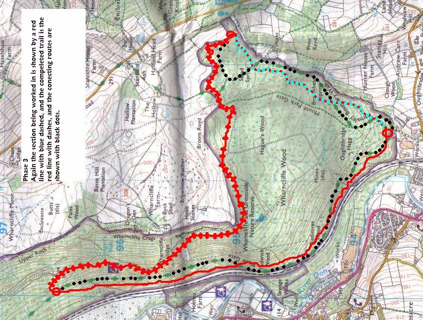
6

7 As can be seen from the maps, it will be possible to open smaller sections when they are complete, when they conveniently link in with the existing trails that will be used as part of the temporary route.
8
9 Trail Specifications - 1 IMBA trail construction specifications Aims & Objectives The creation of a top-level recreational facility for wide cross section of users.the creation of a challenging premier MTB facility, able to draw enthusiast &highly experienced level mountainbikers, whilst still being enjoyed by moderatelyexperienced mountainbikers The systematic provision of increased off road, and where possible off forest road access within the woodland, maximising singletrack and providing challenging routes whilst minimising uncontrolled access or environmental disturbance. Provision of an aesthetically pleasing & fulfilling countryside experience. Primary Considerations Avoidance of environmental degradation or wildlife disturbance, prevention of trail tread creep. Particular consideration must be given to the presence of nesting schedule 1 bird species in areas of the forest. Avoidance of user conflict, particularly in those areas where trails / users meet or share trails. Restriction of users to on trail activity, corralling of users into chosen areas of woodland and avoidance of straying or undesired activities. Particular avoidance of conflict with ecological, historical or forest operation interests. Minimising visual / perceptive impact. Provision of interpretative & educational facilities for trail users. Prevention of watercourse disturbance or pollution. Ability of trail to support all weather use with minimal construction & maintenance costs. Road safety on areas of trail that may meet or cross public & forest roads. General safety of trail and control of user speeds. Public liability in event of user injury. Trail Specifications - 2 Proposed Construction Specifications Research carried out by IMBA has produced well established trail design and construction guidelines, these are detailed in IMBA s Building Better Trails Handbook. Further work in the UK has produced variations of these plans that are particularly suited to Britain s wetter and heavier used trails. It is proposed that trails should be constructed to support a trail tread width of mm for MTB and foot access, and mm for horse routes. Trail line will be raked and cleared of physical obstructions to denote trail line & allow safe passage, No further ground preparation is required. It is envisaged that this construction method will be used on those areas of the trail which are already reasonably condusive to passage, with well structured free draining soils, and a resilient surface already present. Constructed Trail Soil (loam) and vegetation will be cleared from the trail, exposing mineral soil underneath. Tread will require a minimal 5% outslope to facilitate drainage, along with the wide dispersal of removed soil onto downhill side. Final preparation of trail will involve the smoothing & /or compaction of exposed mineral soil to a reasonable standard. Exposed roots and stone need not be removed. Further stone may be used to denote trail line and corral users onto correct trail line. Where necessary constructed trail will be used in conjunction with full bench construction or other recognised IMBA trail construction techniques dependent on slope and ground conditions.
10 Hardened Trail As above, but exposed mineral soil will be capped with a layer of Crusher run stone(80mm to dust) With high fines content, with a surface layer of compacted dust laid down wet (it is imperative that all stone is compacted as soon as it goes down otherwise the fines will get washed out and it will be useless) to a minimum fill depth of 80mm. Additional exposed stone may be embedded within the trail edge or tread as trail features or to denote trail line. As with Constructed Trail, IMBA construction techniques will be used in conjunction where ground conditions require. Trail Specifications - 3 Armoured Trail Where required, mineral soil will be sealed with a layer of rock and/or broken stone, before capping with crusher run stone (80mm to dust) With high fines content, which will be compacted as per hardened trail. It is envisaged that this level of construction will only be required on steep slopes or areas with particularly unstable soil. Raised Trail / Armoured Raised Trail In areas of wet soil, or where extensive water problems may occur, trails may be constructed as per hardened trail, but laid on unprepared ground. Extensive amounts of broken stone may be required to build a secure platform for the construction of trail tread, particularly where the trail may be required to support horse passage. Boardwalk To avoid any risk of watercourse disturbance, it is envisaged that some short areas of boardwalk may be constructed to allow MTB passage without impacting on streams or adjoining riparian zones. Proposed construction from rail sleeper supports, 100x25mm cellcured softwood rails with chicken mesh surface to prevent slipping. Culverts Large watercourses or lateral obstructions may be passed by use of bridges or culverts as deemed necessary (it is noted that often culverts provide a more user friendly passage, in addition construction regulations and risk of damage are often less extreme with the creation of a culvert than a full bridge). Materials It is proposed that stone, wherever possible, should be locally collected, either from local loose stone or established borrow pit quarries located within the woodland. Trail surface materials as already specified. Trail Specifications - 4 Construction The selection of a single route, which is of a higher quality & rider desirability is likely to increase user pressure on the trail, to combat this it is proposed that a widespread programme of trail hardening and reconstruction should be undertaken. Funding for proper construction with machine and personnel (contractors) must be viewed as a priority. The possibility of Lottery Sports council partial funding for trail construction in currently being investigated by IMBA. Recent FE trail construction in Wales has shown the advantage of proper machine use in trailbuilding. Pioneering work by Daffyd Davis at Coed-Y- Brenin and other Welsh forests has also shown the effect of trail construction to IMBA standards on both construction and maintenance costs. User Facilities Adequate facilities are already available within the forest, although the provision of a pay for use bike washing facility would be advantageous, as might the
11 stocking of minor accessories, such as inner tubes, in the forest visitor centre & shop. Interpretation It is considered as vital that any development of trails should include trailhead interpretation boards, giving route information such as distance, terrain, conditions and technical difficulty. It should also carry details of local emergency contacts (and nearest payphone) as well as information on the FE cycling programme, IMBA and Singletraction. The existing trail route marker system provides an effective, discreet waymarking method, and is regarded as being totally in keeping with the aims of the new trail.
APPENDIX D: SUSTAINABLE TRAIL DESIGN. APPENDICES Town of Chili Parks and Recreation Master Plan Update
 APPENDIX D: SUSTAINABLE TRAIL DESIGN APPENDICES Town of Chili Parks and Recreation Master Plan Update Sustainable Trail Construction Sustainable trails are defined by the US Forest Service as trails having
INTRODUCTION. Mailing address: Burke County Community Development Attn: Tim Johnson P. O. Box 219 Morganton, NC
 REQUEST FOR QUALIFICATIONS: PROFESSIONAL, EXPERIENCED TRAIL BUILDERS FOR THE CONSTRUCTION OF THE FONTA FLORA STATE TRAIL LAKE JAMES SECTION BURKE COUNTY COMMUNITY DEVELOPMENT INTRODUCTION Burke County
Understanding user expectations And planning for long term sustainability 1
 Understanding user expectations And planning for long term sustainability 1 What is a natural surface trail? It can be as simple has a mineral soil, mulched or graveled pathway, or as developed as elevated
Mt. Hood National Forest
 United States Department of Agriculture Forest Service Mt. Hood National Forest Zigzag Ranger District 70220 E. Highway 26 Zigzag, OR 97049 503-622-3191 Fax: 503-622-5622 File Code: 1950-1 Date: June 29,
2. STAKEHOLDER FEEDBACK // What We Heard
 1. QUARRY ROAD TRAIL // Welcome to the Information Session PROJECT DESCRIPTION WHY WE ARE HERE Quarry Road Trail is a popular commuter trail and recreational area for Calgarians. 1. To report citizen feedback
Specification for Grip blocking using Peat Dams
 Technical Guidance Note 1 Specification for Grip blocking using Peat Dams 1. Introduction Moorland drains (grips) have been dug across much of the Yorkshire upland peatlands. Many of these grips have become
Bear Creek Habitat Improvement Project
 06/10/10 Bear Creek Habitat Improvement Project El Paso County, Colorado Pike National Forest and Colorado Springs Utilities Owned Land Report prepared by: Eric Billmeyer Executive Director Rocky Mountain
Thank you for the opportunity to comment on the proposed action to add trails and trailheads to the Red Rock District trail system.
 July 14, 2010 Jennifer Burns Red Rock Ranger District PO Box 20429 Sedona, AZ 86341 Flagstaff Biking Organization PO Box 23851 Flagstaff, AZ 86002 Dear Jennifer- Thank you for the opportunity to comment
Appendix 3. Greenway Design Standards. The Whitemarsh Township Greenway Plan
 Appendix 3 Greenway Design Standards This chapter discusses two design standards for the greenway types discussed above. First, trail design standards are presented together with trailhead facilities and
Trails Technical Committee
 Trails Technical Committee Winter 2017 Draft Report Alignment Proposals for the Inyo National Forest and the Town of Mammoth Lakes Map ID #S18 February 08, 2017 Map ID #S18 Key Agreements As of February
Appendix A Appendix A (Project Specifications) Auk Auk / Black Diamond (Trail 44) Reroute
 Auk Auk / Black Diamond (Trail 44) Reroute") Appendix A (Project Specifications) Auk Auk / Black Diamond (Trail 44) Reroute I. Proposed Action: This project proposes to reroute approximately 1,800 feet of a 50 inch wide trail, off of private property
Appendix A (Project Specifications) Auk Auk / Black Diamond (Trail 44) Reroute I. Proposed Action: This project proposes to reroute approximately 1,800 feet of a 50 inch wide trail, off of private property
Procedure for the Use of Power-Driven Mobility Devices on Mass Audubon Sanctuaries 1 September 17, 2012
 Procedure for the Use of Power-Driven Mobility Devices on Mass Audubon Sanctuaries 1 September 17, 2012 Background As part of Mass Audubon s mission to preserve the nature of Massachusetts for people and
Rule Governing the Designation and Establishment of All-Terrain Vehicle Use Trails on State Land
 Rule Governing the Designation and Establishment of All-Terrain Vehicle Use Trails on State Land 1.0 Authority 1.1 This rule is promulgated pursuant to 23 V.S.A. 3506. Section 3506 (b)(4) states that an
Permeable RECREATIONAL TRAILS
 SMART EARTH SOLUTIONS Permeable RECREATIONAL TRAILS GEOWEB GEOPAVE GEOTERRA Innovative Solutions for Designing & Building Trails. Trail Surface Stabilization The key to planning and building trails into
DATE: 23 March, 2011 TO: Communities FROM: BlazeSports America. RE: Accessible Trails Checklist 1
 M E M O R A N D U M DATE: 23 March, 2011 TO: Communities FROM: BlazeSports America RE: Accessible Trails Checklist 1 The purpose of the Accessible Trails Checklist (below) is to help the community review
National Forests and Grasslands in Texas
 United States Department of Agriculture Forest Service National Forests and Grasslands in Texas Sam Houston NF 394 FM 1375 West New Waverly, Texas 77358 Phone 936-344-6205 Dear Friends, File Code: 1950
Form for Project Descriptions - December 2013 version! 1. Stone Valley Cooperative Recreation Area (SVCRA) Project Description
 Project Description") Form for Project Descriptions - December 2013 version 1 Stone Valley Cooperative Recreation Area (SVCRA) Project Description The Stone Valley partners request that proposed work on land within the SVCRA
Form for Project Descriptions - December 2013 version 1 Stone Valley Cooperative Recreation Area (SVCRA) Project Description The Stone Valley partners request that proposed work on land within the SVCRA
Management Standards for Recreational Trails
 Management Standards for Recreational Trails First edition October 2008 The National Trails Office The National Trails Office (NTO) is a programme run by the Irish Sports Council building on the work of
Property access tracks
 Property access tracks Planning, location, construction and maintenance The need for farm roads and tracks The efficient running of a property depends on, among other things, ready access to various locations
Table of Contents. page 3 Long term Goals Project Scope Project History. 4 User Groups Defined Trail Representative Committee. 5 Trail Users Breakdown
 Launched April 27th, 2010 1 Table of Contents page 3 Long term Goals Project Scope Project History 4 User Groups Defined Trail Representative Committee 5 Trail Users Breakdown 13 Trail Users Desires 16
American Conservation Experience
 ACE Project Report For Tonto National Forest, Arizona Trail Association and Arizona State Parks Title of Project: 4 Peaks Trail Maintenance Award Contract Number: ASP NM11021 Project Partner: Paul Burghard
The Whitefish Trail
 The Trail - 2017 Trail Construction Specifications & Scope of Services The Lower Haskill section of Trail construction will take place on two different land ownerships: City of and Iron Horse. This section
Felixstowe Branch Line FAQ
 Felixstowe Branch Line FAQ How was the location of the track doubling work decided? We undertook a study to identify how to meet the freight demand along the Felixstowe Branch Line by modelling the route.
Bibbulmun Track. Cape to Cape Track. Two of the world s great long distance walking tracks. 973 km. 135 km km Off-road cycle touring
 Trail revitalising Western Australia Bibbulmun Track 973 km Cape to Cape Track 135 km Two of the world s great long distance walking tracks 1062 km Off-road cycle touring Trail revitalising 1. Framework
TRAIL MAINTENANCE AND CONSTRUCTION MANUAL
 TRAIL MAINTENANCE AND CONSTRUCTION MANUAL MAINTAINING THE TRAIL CORRIDOR GENERAL MAINTENANCE Debris and Obstacles Remove dangerous obstacles that riders may fall on - logs and branches one-half inch in
GATEWAY PHASE 2. U.S. Forest Service and the Mount Shasta Trails Association
 GATEWAY PHASE 2 U.S. Forest Service and the Mount Shasta Trails Association PROJECT DEVELOPMENT Brief history - Gateway Phase 1 - IMBA conceptual plan - BikeShasta: concert series - USFS & MSTA partnered
Port Gamble Shoreline Area Conceptual Trail Proposal
 The North Kitsap Trails Association is pleased to be a partner to the Kitsap Forest and Bay Project and assist Kitsap County, Forterra, Olympic Property Group, Great Peninsula Conservancy and the Port
Kelly Motorized Trails Project Proposed Action
 Kelly Motorized Trails Project Proposed Action November 28, 2011 The Flagstaff Ranger District of the Coconino National Forest is seeking public input on the proposed Kelly Motorized Trails Project (formerly
ROAD AND TRAIL PROJECT APPROVAL
 ROAD AND TRAIL PROJECT APPROVAL www.marincountyparks.org Marin County Parks, 3501 Civic Center Dr, Suite 260, San Rafael, CA 94903 DATE: July 12, 2017 PRESERVE: Gary Giacomini Open Space Preserve PROJECT:
MORAY COAST TRAIL - Notes on multi-use access
 MORAY COAST TRAIL - Notes on multi-use access The Moray Coast Trail in the north-east of Scotland is one of Scotland s Great Trails. Approximately 50 miles long, the route links settlements between Findhorn
Land Management Summary
 photo credit: ANGAIR Anglesea Heath Land Management Summary The Anglesea Heath (6,501 ha) was incorporated into the Great Otway National Park in January 2018. This provides an opportunity to consider the
Proposed Peninsula Bay Bike Track Development
 Proposed Peninsula Bay Bike Track Development May 2018 BACKGROUND The area of land at the northern extreme of Wanaka's Peninsula Bay development (Lot 923 DP 501325), currently owned by Infinity Investment
Loop Walks Key Criteria
 Loop Walks Key Criteria 1/31/2012 CONTENTS Mission... 3 Background... 3 Phase 1... 3 Guidelines... 3 Occasional Walker... 5 Level of Difficulty... 5 Loop Furniture... 6 1. Mapboard... 6 2. Waymarkers...
5.0 OUTDOOR RECREATION OPPORTUNITIES AND MANAGEMENT
 5.0 OUTDOOR RECREATION OPPORTUNITIES AND MANAGEMENT 5.1 Introduction This section describes the range of recreational activities that currently take place in Marble Range and Edge Hills Parks, as well
Trail Master Plan. Hungry Mother State Park
 Trail Master Plan For Hungry Mother State Park Prepared for Virginia State Parks Presented by Trail Dynamics, LLC PO Box 664 Cedar Mountain, NC 28719 www.traildynamics.com 1 1 Table of Contents Introduction
Island Eastern Corridor Boardwalk-Cycleway Feasibility Study
 For discussion on 12 January 2012 Island Eastern Corridor Boardwalk-Cycleway Feasibility Study PURPOSE The purpose of this paper is to understand and promote the feasibility of incorporating the Harbourfront
Wimpole Estate Multi-use Trail 2017 Frequently asked questions
 Wimpole Estate Multi-use Trail 2017 Frequently asked questions Why does the National Trust want to create new trails? We want to play our part in helping to reconnect the nation with the outdoors. At the
Abbey Chesterton bridge Questions & Answers
 Abbey Chesterton bridge Questions & Answers Please click on links below to go to individual subjects: Bridge location and access routes Timescales Bridge details and accessibility Construction compound
Design Considerations For Accessible Parks & Trails
 Design Considerations For Accessible Parks & Trails Measuring Up: Campbell River 2008 Dave Calver Consulting City of Campbell River Legacies Now: Measuring Up Design Guidelines Design Considerations for
Great Pond Mountain Conservation Trust Request for Bids Wildlands Hillside Trail Relocation and Restoration Project
 Great Pond Mountain Conservation Trust Request for Bids Wildlands Hillside Trail Relocation and Restoration Project Project Description: Great Pond Mountain Conservation Trust (GPMCT), a nonprofit land
Non-motorized Trail Plan & Proposal. August 8, 2014
 Town of Star Valley Ranch, Wyoming and the Star Valley Ranch Association in partnership with the USDA Forest Service, Bridger-Teton National Forest, Greys River Ranger District Non-motorized Trail Plan
CRAZY HORSE TRAIL GUIDE
 CRAZY HORSE TRAIL GUIDE Abridged Version: July 2016 This is a short form of our interpretive trail guide for the Crazy Horse Trail. The full version of the guide has a more detailed description of the
Walking Track Classification System Parks and Wildlife Service
 Appendix A Walking Track Classification Specifications Walking Track Classification System Parks and Wildlife Service This Walking Track Classification System is the outcome of a review of the track classifications
Theme: Predominately natural/natural appearing; rustic improvements to protect resources. Size*: 2,500 + acres Infrastructure**:
 Recreation Opportunity Spectrum (ROS) Classes The Recreation Opportunity Spectrum (ROS) provides a way to describe the variations in the degree of isolation from the sounds and influences of people, and
Curbar And Froggatt Edge Proposed Concessionary Bridleway Works
 Curbar And Froggatt Edge Proposed Concessionary Bridleway Works This route is currently a footpath (PROW) and after consultation there is a want for it to become a concessionary bridleway. The route will
PRESERVE TRAIL GUIDELINES Resource Management Guidelines for Trails in Preserves
 PRESERVE TRAIL GUIDELINES Resource Management Guidelines for Trails in Preserves County of San Diego Department of Parks and Recreation April 2018 sdparks.org Table of Contents CHAPTER 1: INTRODUCTION...
MORGAN CREEK GREENWAY Final Report APPENDICES
 APPENDICES MORGAN CREEK GREENWAY Appendix A Photos of Existing Conditions in Trail Corridor Photos of existing conditions Main trail corridor - February 2009 Photos of existing conditions south bank Morgan
Barbour Rock Recreation Trails Plan Columbia Valley Greenways Trails Alliance and Columbia Valley Cycling Society
 7/9/2016 Barbour Rock Recreation Trails Plan Columbia Valley Greenways Trails Alliance and Columbia Valley Cycling Society Kootenay Planning Consultants 1 Columbia Valley Greenways Trail Alliance P.O.
Trail Phasing Plan. Note: Trails in the Clear Creek Canyon area (Segments will be finalized in the future to minimize wildlife impacts
 Note: Trails in the Clear Creek Canyon area (Segments 2 5 and a future JCOS connection) will be finalized in the future to minimize wildlife impacts Trail Phasing Plan P Parking 3 Easy Trail Intermediate
September 14, Comments of the Colorado Trail Foundation On the USFS Scoping Notice of August 13, 2010 RE: the relocation of the CDNST/CT Page 1
 THE COLORADO TRAIL FOUNDATION Comments on the U.S. Forest Service Scoping Notice of August 13, 2010 Regarding the Relocation of THE COLORADO TRAIL AND CONTINENTAL DIVIDE NATIONAL SCENIC TRAIL From La Garita
Appendix 1: Best Management Practices For Hang Gliding and Paragliding in Jasper National Parks
 Appendix 1: Best Management Practices For Hang Gliding and Paragliding in Jasper National Parks Name of Best Management Practice Best Management Practices for Hang Gliding and Paragliding in Jasper National
Evergreen Trail School
 Evergreen Trail School Making Washington a Better Place to Ride Preston, WA & Tiger Mt. Sat, April 9, 2015 8-11:45am: Classroom 11:45-12:45pm: Lunch 12:45-4pm: Trail Work Classroom Agenda Introduction
Unlocking our Coastal Heritage Strand 2 - Watermouth Bay, nr Ilfracombe
 Unlocking our Coastal Heritage Strand 2 - Watermouth Bay, nr Ilfracombe In order to provide a safe route for users of the South West Coast Path this project realigned 265m of the A399 coast road to incorporate
A summary of Draft Makara Peak Mountain Bike Park Master Plan
 A summary of Draft Makara Peak Mountain Bike Park Master Plan OVEMBER 216 Image: Peter Marshall 2 3 Introduction Since it was established in 1998, the Makara Peak Mountain Bike Park (Makara Peak) has grown
Standard waymarked path grading system for Scotland
 Standard waymarked path grading system for Scotland Version 2 July 2015 FOR A HAPPIER, HEALTHIER SCOTLAND Contents Contents Why we need a grading system 3 A Six Part System 4 1. Path Name 5 2. Path Promotion
WEST HIGHLAND WAY Notes on multi-use access
 WEST HIGHLAND WAY Notes on multi-use access The West Highland Way was one of Scotland s four original long distance routes. Now one of Scotland s Great Trails, it is renowned world-wide for the spectacular
DAVA WAY. Notes on multi-use access
 DAVA WAY Notes on multi-use access The Dava Way is a 24 mile (38km) waymarked long distance route based largely on the dismantled Highland Railway Line between Forres, near the Moray Coast in north-east
Agenda. Part I! Trailbuilding! Foundations" Part II! Essential Elements! of Sustainable Trails" Part III # Designing! Sustainable Trails"
 Agenda Part I! Trailbuilding! Foundations" Part II! Essential Elements! of Sustainable Trails" Part III # Designing! Sustainable Trails" IMBA"s mission is to protect# create# and $ enhance quality trail
The Roots of Carrying Capacity
 1 Applying Carrying Capacity Concepts in Wilderness 1872 1964...shall be preserved for the use & enjoyment of the American people...in such manner as will leave them unimpaired for future generations...
TOWPATH MOWING GUIDELINES
 TOWPATH MOWING GUIDELINES 24 September 2007 CONTENTS Introduction Scope and Status of Guidelines Influences on the Guidelines Health and Safety Biodiversity INTRODUCTION Towpath management is a key issue
Blueways: Rivers, lakes, or streams with public access for recreation that includes fishing, nature observation, and opportunities for boating.
 Parks, Open Space and Trails PRINCE WILLIAM COUNTY 2008 COMPREHENSIVE PLAN TRAILS PLAN CONTENTS The components of the trails plan are: Intent Definitions Goals, Policies, and Action Strategies Trails Map
FAQS and Code of Conduct for use under the Tamar Trails heading on the Tamar Valley AONB and Tamar Trails websites: Tamar Trails FAQs
 FAQS and Code of Conduct for use under the Tamar Trails heading on the Tamar Valley AONB and Tamar Trails websites: Tamar Trails FAQs What are the Tamar Trails? The Tamar Trails are 25km of new and improved
Applying Carrying Capacity Concepts in Wilderness
 Applying Carrying Capacity Concepts in Wilderness...shall be preserved for the use & enjoyment of the American people...in such manner as will leave them unimpaired for future generations... CSS 490 Professor
Thank you for this second opportunity to comment on the proposed revisions to the Coconino National Forest Management plan.
 March 8, 2011 Flagstaff Biking Organization PO Box 23851 Flagstaff, AZ 86002 Yewah Lau Coconino National Forest Attn: Plan Revision 1824 South Thompson Street Flagstaff, Arizona 86001 Sent via electronic
Kit Carson-Challenger Ridge Trail Project
 Kit Carson-Challenger Ridge Trail Project Project Accomplishments Report-USFS December 15, 2015 Photo courtesy of Justin Peterson 815 South 25 th Street, Suite 101 Colorado Springs, CO 80904 Dedicated
Presented by Dave Hiatt to attendees at the 11/6/2016 WOHVA Annual Meeting. (Mention the picture above is of the front number plate on my dirt bike)
") Presented by Dave Hiatt to attendees at the 11/6/2016 WOHVA Annual Meeting. (Mention the picture above is of the front number plate on my dirt bike) I have been looking for it ever since Ron Loomis and
Presented by Dave Hiatt to attendees at the 11/6/2016 WOHVA Annual Meeting. (Mention the picture above is of the front number plate on my dirt bike) I have been looking for it ever since Ron Loomis and
ATVANS Trail Assessment for Five Bridge Lakes Wilderness Area Report and Recommendation. December 28, Prepared by.
 ATVANS Trail Assessment for Five Bridge Lakes Wilderness Area Report and Recommendation December 28, 2011 Prepared by Peter Bush Background This report documents the results and recommendations of an all-terrain
Snowmobile GUIDELINES FOR TRAIL SIGNING
 STATE OF NEW HAMPSHIRE BUREAU OF TRAILS Snowmobile GUIDELINES FOR TRAIL SIGNING TRAIL FUNDED BY REGISTRATION FEES Table of Contents Introduction... Some Things to Take Into Consideration... BOT Provided
Group similar facilities together separate dissimilar facilities.
 Park design Principle #1 Group similar facilities together separate dissimilar facilities. Why do we do this? Safety Differences in admission fees Differences in seasonal use Reduce user conflicts Principle
BHS ADVICE ON Dimensions of Width, Area and Height
 BHS ADVICE ON Dimensions of Width, Area and Height 2 In providing specifications for equestrian ways and facilities, The British Horse Society considers all equestrian users, which may result in a high
ETOBICOKE CREEK NORTH TRAIL PROJECT. May 18, 2017 at Michael Power High School 105 Eringate Drive, Etobicoke ON M9C 3Z7
 ETOBICOKE CREEK NORTH TRAIL PROJECT May 18, 2017 at Michael Power High School 105 Eringate Drive, Etobicoke ON M9C 3Z7 1 Purpose of Open House The purpose of today s open house is to present the design
GOLDEN EARS PROVINCIAL PARK
 GOLDEN EARS PROVINCIAL PARK Trail Information as of October 10 th 2015 Do not underestimate the mountainous wilderness of Golden Ears Provincial Park. The combination of rugged terrain and rapidly changing
The National Path Demonstration Site
 The National Path Demonstration Site at Battleby an introductory guide Good paths are essential if people are to enjoy the outdoors. Thoughtful path design really opens up access but there s more to building
Longmont to Boulder Regional Trail Jay Road Connection DRAFT FINAL REPORT
 Longmont to Boulder Regional Trail Jay Road Connection DRAFT FINAL REPORT December 2018 Project Summary Boulder County, Colorado, in partnership with the City of Boulder, is evaluating options for multi-use
October Polhill consultation on new tracks
 October 2016 Polhill consultation on new tracks Brooklyn Trail Builders (BTB) is a community volunteer group that has been building and maintaining trails, planting trees, and removing rubbish in Polhill
Recreation News. Welcome. Chris Jackson. In this Issue: O S U C o l l e ge F o r e s t s
 Recreation News O S U C o l l e ge F o r e s t s In this Issue: Welcome New tree identification posts... New Arboretum Trails New Interpretive Signs Ridge Trail Seasonal Closures Leave No Trace reminder
Attendance Presentation
 TO The Community of Saanich FROM District of Saanich DATE January 30, 2017 RE Meeting Notes Haro Woods Jan 28th Community Engagement Goward House, 2495 Arbutus Road, Victoria BC Attendance In total, 18
KENNESAW MOUNTAIN TRAIL CLUB WORKDAY
 WORKDAY 2-10-18 1 Trail ambassadors or others see next page. 1 work sites TOOLS 15 1 3 1 2 SCHEDULE: 7:15 Start load tools; Send registration stuff out 8:00 Send tools to grassy area near trail head. 8:15
BACKCOUNTRY TRAIL FLOOD REHABILITATION PROGRAM
 BACKCOUNTRY TRAIL FLOOD REHABILITATION PROGRAM Backcountry Trail Flood Rehabilitation A June 2013 Flood Recovery Program Summary In June 2013, parts of Southern Alberta were devastated from significant
Member-led Review of Cycling Infrastructure
 Member-led Review of Cycling Infrastructure Survey Results: A1 Cambridge to Royston June 17 cambridgeshire.gov.uk Contents 1. Introduction... 3. About you... 3.1 Age... 3. What is your gender?... 3.3 Do
Lake Apopka Trail Loop Design Guidelines
 November 2002 Prepared for 14908 Tilden Road Winter Garden, FL 34787 Prepared by 140 North Orlando Avenue Suite 295 Winter Park, FL 32789 November, 2002 I. INTRODUCTION...1 II. DESIGN GUIDELINES FOR TRAILS...3
Buena Vista Community Trails Plan
 Buena Vista Community Trails Plan Prepared by the Buena Vista Trails Advisory Board For the Buena Vista Board of Trustees May 2008 Table of Contents Acknowledgments 1 Introduction 1 I. Trails and the Town
Chapter 10: Recreation Trail Management. List of Figures
 Chapter 10: Recreation Trail Management Chapter 10: Recreation Trail Management... 1 List of Figures... 1 10.1 Introduction... 2 10.2 Trail Planning... 2 10.2.1 Trail Concept Planning... 3 10.2.2 Trail
Appendix C. Tenderfoot Mountain Trail System. Road and Trail Rehabilitation Plan
 Appendix C Tenderfoot Mountain Trail System Road and Trail Rehabilitation Plan All rehabilitation work would be under the direction of the District Fisheries Biologist, the Forest Hydrologist, and/or the
Chorley Park Trail Connection New Design Options. Information Booklet Prepared for June 9, 2014 Public Meeting
 Chorley Park Trail Connection New Design Options Information Booklet Prepared for June 9, 2014 Public Meeting Chorley Park Trail Booklet June 9, 2014 Page 1 of 12 Our Goals for the Chorley Park Trail Connection
General Issues with the Portland Parks & Recreation Trail Design Guidelines for Portland s Park System ( Portland Guidelines )
") Why the City of Portland s current Trail Design Guidelines (2009) are substandard & need to be updated. For purposes of this discussion we will be referring to the following natural surface trail guidelines:
Why the City of Portland s current Trail Design Guidelines (2009) are substandard & need to be updated. For purposes of this discussion we will be referring to the following natural surface trail guidelines:
Welcome to the future of Terwillegar Park a Unique Natural Park
 Welcome to the future of Terwillegar Park a Unique Natural Park 1 Introduction The Terwillegar Park Concept Plan study will develop an overall concept plan, management objectives and development guidelines
Salmo Ski Hill 2015 Operating Season SVTS Annual Work Plan
 Salmo Ski Hill 2015 Operating Season SVTS Annual Work Plan 2014 Review Our goal for 2014 had been to complete construction of a 2.5km loop trail (Figure 1) with scouting and possibly layout for the remainder
ACCESS STATEMENT LAKE VYRNWY HOTEL & SPA
 ACCESS STATEMENT LAKE VYRNWY HOTEL & SPA August 2014 Access Statement for Lake Vyrnwy Hotel & Spa Overview: On the site at Lake Vyrnwy is a 52-bedroom Hotel, a formal Restaurant open to both staying guests
Byelorussian Battlefields
 Byelorussian Battlefields All Flames Of War battles need terrain! Battles in the Second World War were rarely fought over open plains with unobstructed lines of sight. In Flames Of War, wide open tables
LANDER AREA MASTER TRAILS PLAN. Lander Cycling Club November 2012
 LANDER AREA MASTER TRAILS PLAN Lander Cycling Club November 2012 Table of Contents A. Overview 3 B. Introduction 4 C. Visitor Profile 5 D. Benefits to the Community 6 E. Area wide Goals and Objectives
AGENDA LANARK COUNTY MUNICIPAL TRAILS CORPORATION BOARD OF DIRECTORS
 AGENDA LANARK COUNTY MUNICIPAL TRAILS CORPORATION BOARD OF DIRECTORS Monday, September 17, 2012 8:30 a.m. to 10:00 a.m. Lanark County Administration Building Drummond/North Elmsley Boardroom Page President,
RECREATION TRAILS MASTER PLAN
 RECREATION TRAILS MASTER PLAN Prepared by: and The Kimberley Advisory Trail Planning Committee April 2003 Table of Contents 1.0 Project Description 4 2.0 Goals 4 3.0 Planning Principles 4 4.0 Master Planning
College Forests Recreation Planning Focus Group Results Summary, Spring 2013
 Broad Themes by Prevalence 1) Trails 2) University Relations & Management 3) User Conflict 4) Access 5) Use Types and Extent 6) Ecology 7) Change 8) Information & Education College Forests Recreation Planning
1. Study the Ordnance Survey Map of Brodick, Isle of Arran.
 1. Study the Ordnance Survey Map of Brodick, Isle of Arran. To find the map go to: > http://www.bing.com/maps/ > change maps type to Ordnance Survey Map from Road. > search for Glenrosa Water (it is near
Appendix 8 Sawston Greenway Review
 Appendix 8 Sawston Greenway Review Nigel Brigham & Associates A report for 1 Introduction This report is based on fieldwork carried out in 2016 to review the Greenway network around Cambridge as shown
Arrowhead Park Flow Trail Construction 16 April 2018 SPECIFICATIONS AND SCOPE OF WORK ARROWHEAD PARK FLOW TRAIL CONSTRUCTION
 SPECIFICATIONS AND SCOPE OF WORK ARROWHEAD PARK FLOW TRAIL CONSTRUCTION Section 1: Project Description and Scope 1.1 General Project Description and Scope 1.2 Mountain Bike Specific Flow Trail 1.3 Signage
Access Statement for Leighton Hall
 Access Statement for Leighton Hall Introduction Leighton Hall is located 3 miles from J35 of the M6. Brown tourism signs are in situate to bring you right to the door. There is plenty of parking, with
Welcome KROSNO CREEK DIVERSION PROJECT CLASS ENVIRONMENTAL ASSESSMENT
 Welcome KROSNO CREEK DIVERSION PROJECT PUBLIC INFORMATION CENTRE # 1 Tonight s Presentation Study Overview Background Existing Conditions Alternative Solutions Preliminary Preferred Solution Next Steps
Tracy Ridge Shared Use Trails and Plan Amendment Project
 Tracy Ridge Shared Use Trails and Plan Amendment Project Scoping Document Forest Service Allegheny National Forest Bradford Ranger District McKean, County, Pennsylvania In accordance with Federal civil