March 12, 2014 DRAFT Burgess and Standard Tube Parks Master Plan 2014 to 2024
|
|
|
- Elijah Dixon
- 5 years ago
- Views:
Transcription

1 March 12, 2014 DRAFT Burgess and Standard Tube Parks Master Plan 2014 to 2024 Produced by the Upper Thames River Conservation Authority For the City of Woodstock 1
2 Prepared by the Upper Thames River Conservation Authority for the City of Woodstock. Principle Authors Cathy Quinlan, Terrestrial Biologist Brad Hertner, Community Partnership Specialist Photos All photos in this document were taken by Cathy Quinlan, UTRCA, unless otherwise noted. Cite as Upper Thames River Conservation Authority. Burgess Park and Standard Tube Master Plan Prepared for the City of Woodstock. This report is available on-line at: or ISBN
3 Acknowledgements Thanks to the City of Woodstock Parks and Recreation staff, specifically Brian Connors and Chris Kern, for their guidance, input and support on this project. A special thanks to the Local Advisory Committee for their time, knowledge and input with the Master Plan. Finally, thanks to the team at the Upper Thames River Conservation Authority, especially Tracey Haycock for the mapping and Eleanor Heagy for the editing and layout. Cathy Quinlan Brad Hertner (Principle Authors) 3
4 Executive Summary Significance The Burgess/Standard Tube Park is a 195 acre (79 ha) site along the South Thames River in west Woodstock, one of the largest natural areas in the city. The park contains rich floodplain forests, hardwood swamps, marshes, ravines and regenerating farm fields. The Burgess Park Wetland (UT60), a provincially significant wetland, is located immediately upstream of the Thames River Wetland (UT63), creating a long, vegetated river corridor. The protected river corridor is a hot spot for wildlife and protects the quality of the river water. The Burgess/Standard Tube Park is popular with people who use the 9 km trail system. Process The Burgess Park/Standard Tube Park Master Plan has been completed collaboratively by the UTRCA, City of Woodstock, and interested community organizations and individuals. An online survey was created and promoted in the newspaper, on stakeholder websites, through , and by word-of-mouth. Some 111 surveys were completed, and their results summarized. At a community meeting in June 2013, 35 people attended and gave input on issues, concerns and opportunities for the parks. From this meeting, a Local Advisory Committee (LAC) was formed, consisting of 12 members. They met four times to discuss issues, opportunities and help develop recommendations. A review of City and UTRCA files and other maps and sources was reviewed to describe the history of the parks, their acquisition, development and other works and issues over the years. Several on-site visits were conducted to examine the vegetation of the fallow fields and The Island, as well as issues and amenities along the trails and access points. Results A series of 17 recommendations are made, some with sub-recommendations, addressing issues from field naturalization, new trails, retiring trails, access point amenities, trailhead signage and so on. A summary table of the recommendations is provided along with estimated costs and priorities. A major recommendation is the naturalization of the four fallow farm fields totaling 18.5 ha (45.7 acres) involving tree planting with school groups and invasive species management. The creation of three new loop trails through these fields to the new subdivisions planned to the north will add another 3 km of walking/cycling opportunities. Maps 11 to 15 show the current and future trail system and naturalization plans. These recommendations have been reviewed by the Woodstock Recreational Advisory Committee. 4
5 Table of Contents Acknowledgements... 3 Executive Summary... 4 Significance... 4 Process... 4 Results... 4 Table of Contents... 5 List of Maps... 7 Chapter 1. Background General Description of the Study Area Purpose of the Master Plan Methodology Chapter 2. Historical Overview Pre-European period to Historic Air Photo Sequence Purchase of Burgess Park, Purchase of Standard Tube, Recreation Needs Analysis, Park Development Concept & Park Design, Trail and Access Development, Golf Course Proposal, Agricultural Fields, 1979 to Pits and Mounds Restoration of Field 5, Sewers and Roads, 2010 to Dead Ash Tree Removal and Reforestation, 2012 to Chapter 3. Physical Features and Vegetation Soils, Surficial Geology and Glacial History Floodlines and Elevation Small Watercourses and Oxbows Vegetation Communities Moist Deciduous Forest Deciduous Swamp (Wetland) Deciduous Thicket and Meadow Marsh (Wetland) Cultural Thicket, Savanna and Meadow Cultural Plantation Deciduous and Coniferous Created Tallgrass Prairie with Pits and Mounds Provincially Significant Wetland Wildlife Species at Risk and Locally Rare Species Natural Heritage Linkages Chapter 4. Existing Access Points and Trails Existing Access Points and Ammenities Existing Trails Chapter 5. Issues, Opportunities and Recommendations Fallow Farm Field Naturalization Field
6 5.1.2 Field Field Field Field New Trails and Access Points in Fields 1 to Reducing the Number of Existing Trails Riverbank Erosion Near Existing Trails Possible Foot Bridge(s) Park Names, Trail Names and Entrance Signs Trailhead and Permitted Use Signage at Access Points Access Point Amenities: Garbage Cans and Port-a-Johns Benches and Picnic Tables Stockpile Areas Old Foundations from Burgess Homestead and Old Rail Abutment Boundary Survey Pine Plantation Thinning Connection between Dundas Street and 11 th Line Access Points Fencing and Gate near Tecumseh Street Entrance Pre-Contact Sites Accessibility for Ontarians with Disabilities Act (AODA) Chapter 6. Summary of Recommendations, Costs & Priorities Accessibility for Ontarians with Disabilities Act New trails, amenities and signage must meet current ADOA standards for Built Environment References Appendices Appendix A-1. Master Plan Public Survey Summary Appendix A-2. Community Meeting Notice Appendix A-3. Minutes of the Community Meeting, June 26th, Appendix B Park Development Concept Plan Map by Biologic Appendix C. Embro Sewer Line Route through Hartley/Hargreaves land and Burgess Park Appendix D. Future Road Route through the Hartley/Hargreaves Subdivision & Burgess Park Appendix E-1. Burgess/Standard Tube Detailed Vegetation Communities Maps Appendix E-2. Burgess/Standard Tube Parks, Vegetation Community Details (see Appendix E-1 maps) Appendix E-3. Wetland Plant List Appendix E-4. Botanical Inventory of Field 1, June 14 th, Appendix F-1. Bird Sightings Appendix F-2. Reptile, Amphibian and Mammal Sightings Appendix G-1. Naturalization Plan Details for Field Appendix G-2. Naturalization Plan Details for Field Appendix G-3. Naturalization Plan Details for Field Appendix G-4. Naturalization Plan Details for Field Appendix G-5. Legislation Governing Pesticide Use Appendix H. Map of Burgess/Standard Tube Park within the 2007 City of Woodstock Trail Master Plan Map 103 Appendix I. Westminster Ponds/Pond Mills ESA Brochure (page 1 of 2) Maps
7 List of Tables Table 1. Public Access Points Table 2. Recommended Naturalization Plan for Fields 1 to 4 Table 3. Park and Trail Name Options List of Maps Map 1. Study Area Setting Map 2. Property Ownership and Neighbouring Lands Map 3. Historical Aerial Photographs: 1945, 1955 and 1972 Map 4. Historical Aerial Photographs: 1978, 1989 and 2000 Map 5 Historical Aerial Photographs: 2006 and 2010 Map 6. Surficial Geology Map 7. Soils Map 8. Elevation Map 9. Flood and Regulation Limits Map 10. Vegetation Communities Map 11. Existing Trails, Access Points and Cultural Features Map 12. Future Trail Plan Map 13. Naturalization Plan Map 14. Naturalization, Trail and Access Point Plan Map 15. Option 2 Naturalization, Trail and Access Point Plan (with bridge option) 7
8 8
9 Chapter 1. Background 1.1 General Description of the Study Area Together, the Burgess and Standard Tube Parks form a 95.6 ha (236 ac) passive parkland in the west end of Woodstock (see Map 1). The parks are located between Dundas Street to the south and Sally s Creek subdivision to the north. The parks are situated along a 2.5 km stretch of the South Thames River. Immediately west of the parks is the Municipality of East Zorra Tavistock. Burgess Park (43.6 ha, ac) is owned by the Upper Thames River Conservation Authority (UTRCA) and managed under agreement with the City of Woodstock. Standard Tube Park (52 ha, ac) is owned and managed by the City of Woodstock s Parks and Recreation Department. Map 2 shows the boundary of both parks and the neighbouring owners. Approximately 80% of the park area is wooded or naturalized and 20% is fallow farm field. There are about 9 km of managed trails in the parks that are used for hiking, walking, running, bicycling, nature viewing, fishing, and passive enjoyment. The parks are designated Open Space in the Official Plan on Schedule W-1 for the City of Woodstock. They are zoned OS2 (Open Space 2) in the City of Woodstock Zoning By-law. OS2 lands are protected for passive recreation and habitat preservation. The Burgess Park Wetland (UT60) that spans both Burgess and Standard Tube Parks is recognized as a Provincially Significant Wetland by the Ontario Ministry of Natural Resources. Burgess/Standard Tube Park is one of the largest natural areas in the City. The parks are important links in a large, natural riparian (river-side) park and floodplain system that stretches from Innerkip, through Pittock Conservation Area and downstream to Beachville. 1.2 Purpose of the Master Plan Several factors have led to the need for a Master Plan for the Burgess/Standard Tube parklands. In the last decade there has been considerable activity and attention in the parks including a golf course proposal, ash tree dieback, new sewer lines, reforestation and naturalization projects, farmland lease expiration, and new neighbouring subdivisions planned. Many of the pressures on the parks are the result of rapid suburban development of the north end of the City of Woodstock since annexation in 2001 and Now that the agricultural fields are no longer farmed, there is a need for a naturalization plan for four of the five fields (one has already been successfully naturalized). Also, there is a need to coordinate and plan for new trails through these fields to connect to the planned subdivisions and the existing trails. There has never been a master plan for either park since the trail network was developed and the area was actively promoted. Natural parkland sites need management to preserve the ecological integrity and to control access, limit conflicts, educate users and allow safe recreational opportunities. 9
10 The City of Woodstock contracted the UTRCA to undertake the master plan in the spring of Key components of this master plan are: A review of the existing trail system to minimize impacts on the ecology while meeting visitor desires, A review of the access points and signage, A plan(s) to naturalize fallow farm fields and incorporate new trails, A review of the existing infrastructure such as benches, parking lots, outhouses, A review of signage/education needs, A review of the naming of the parks and trails, To document major changes that have occurred to the ecology of the parks, To flag any issues, and To identify stressors and their impacts. 1.3 Methodology Background documents were assembled and reviewed including: correspondence, reports, development reports, historic and present air photos, trail maps and GIS layers, bio-physical information, ecological inventories, etc. A series of maps was produced to illustrate the location and ownership of the parks, existing trails and possible trail and restoration options. The Master Plan study was officially launched with a news release and media interviews in May of A community consultation process was undertaken to solicit community input. An on-line survey was created and completed by 111 people. A community meeting was hosted on June 26 th, 2013 at Goff Hall, in the evening. The public meeting flyer, minutes and survey results are included in Appendix A. Attendees viewed the maps, the summarized results of the survey and provided feedback on issues. Those interested, signed up to be on a Local Advisory Committee. The consultants continued to gather information and conduct field work to document vegetation types and conditions, opportunities for naturalization and trails, etc. Four Local Advisory Committee (LAC) meetings were held: October 9 th at 7 p.m., November 12 th at noon, December 10 th at 9:30 a.m. and January 24 th at 9:30 a.m. 10
11 Chapter 2. Historical Overview This chapter summarizes the history of Burgess Park and Standard Tube Park before and after they were in public ownership. 2.1 Pre-European period In the pre-european period, the study area was likely used by many First Nations people over the centuries, owing to its location close to the river. The 2007 Archaeologix study of Burgess Park found two pre-contact Aboriginal sites close to the Millenium/Rotary Trail and Unnamed Drain (see Map 11). One site, location 4, was recommended for further assessment because Kettle Point chert debris was found to 1976 The Burgess land was owned by generations of the Burgess family since about 1820, starting with Samuel Burgess and ending with Fred E. and Winnifred Burgess in the 1970s. Figure 1 shows the property owners of East Zorra circa 1876, nine years after Confederation. At that time, the Burgess farm was owned by S.G. Burgess (the J.P. after his name suggests he was a Justice of the Peace). The Standard Tube Park land was owned by T. Cummings. Figure 2 shows the historic town of Woodstock and the original course of the South Thames River more accurately than Figure 1. The Text Box below summarizes the Burgess family history, taken from a 2008 article in the Woodstock Sentinel-Review recounted by the two remaining Burgess sisters, Fran Dopp and Jean McGuire. According to this article, not only did the Burgess family own the land now known as Burgess Park, but they also owned the land now known as Standard Tube Park for a time. The northern property was farmed first and longest. During WWII their farmhouse burned down, so after the war they bought the farm on the adjoining land to the south. The family worked the two farms, about 146 hectares, for several years until the cattle became sick from raw sewage in the river, supposedly dumped by the Standard Tube factory. Though the family sued Standard Tube and won a lawsuit, the family struggled financially and later were forced to sell that farm to Standard Tube Inc. Several years later, in 1976, they got out of farming altogether and sold the original farm to the City of Woodstock. A 2007 Archaeologix study identified three Euro-Canadian locations within Burgess Park (see Map 11). Each of these sites corresponds with the location of the foundations of the Burgess barns (locations 1 and 2) and houses (locations 2 and 3). The buildings were torn down prior to UTRCA ownership. The Archaeologix study found late 19 th and early 20 th century artifacts from the buildings such as glass, nails and porcelain that were determined to be of limited archaeological value. Historic family photos are shown in Figure 3. 11


12 Figure 1. Map of land ownership in East Zorra Township circa 1876 showing the Burgess and Cummings lands. Source: Walker and Miles, Historical Atlas of Oxford County, Figure 2. West Woodstock, circa 1876, showing the original course of the South Thames River. Source: Walker and Miles, Historical Atlas of Oxford County,
13 Burgess Family History Summary The Burgess family emigrated from the British Isles to Boston. Shortly before the onset of the American War of Independence, , these United Empire Loyalists were pushed north to Upper Canada. They eventually moved to a farm on the 6 th Concession of Blenheim, just south of Drumbo. Two brothers were raised on the farm, Merinus and Samuel. Samuel Burgess later settled on about 40 hectares west of the South Thames River where the Burgess Park is today. The farmhouse (circa 1830) was perched atop the highest hill. Samuel s son, Erastus, was born and raised on the farm. Erastus s son Fred O. Burgess was born in Fred O. Burgess built the second house around 1900 (now fronts Tecumseh Street at the park entrance) and it is the only house that remains. Fred O. Burgess s son, Fred Erastus Burgess, built the third home on the property near the original farmhouse. He and his wife, Winifred, had five children including Fran and Jean. Fred E. Burgess served with the Elgin Regiment in Italy during the Second World War. During the war, the family moved off the farm to Delatre Street. Their farmhouse was rented out to generate money. Unfortunately, the old kitchen wood stove was left unattended, starting a fire that burnt the home to the ground. When Fred E. Burgess returned in 1945, the family bought a farmhouse on the adjoining land (presumably on what is now Standard Tube Park). The Burgess clan worked two farms on a vast property (146 ha) that stretched from the 11 th Line to what is now Hwy 59/Vansittart Avenue and down to Dundas Street. Later, the Burgess family was forced to sell some of the land to Standard Tube. The family believed the company was dumping raw sewage into the waterway, causing the cows to become sick. Fred E. Burgess sued the company and won, but lawyer fees took much of the winning settlement. Several years later, after Fred O. Burgess died, Fred E. Burgess stopped farming and, ironically, went to work for Standard Tube. After Fred E. died, his wife Winifred sold the Burgess property to the City of Woodstock and auctioned off almost all of the family s art, documents and items collected throughout their years in Oxford County. Source: Woodstock Sentinel-Review, May 22, 2008, article Home sweet home by Nicole O Reilly. 13


14 Figure 3. Historic photos of the Burgess Family homes and barn, circa Source: Bryan Smith.. 14
15 2.3 Historic Air Photo Sequence The historic aerial photographs shown in Maps 3-5 ( ) tell the story of the Burgess/Standard Tube lands as they transitioned from farmland to natural parkland and trails air photo (Map 3): The majority of the Burgess/Standard Tube Park lands were in agricultural use. The higher ground, along with a small field along the railroad tracks, was in crops. The lowland areas along the river were used as cattle pasture, likely. The cattle, along with regular flooding and ice scour, probably kept the tree cover to a minimum in the floodplain area. The pasture land extended east of the river where industry is situated today. The houses and barns of the Burgess farm are visible. The laneway to the houses and barns is visible (this laneway became the basis for the present-day Upper Trail). At the south end, Dundas Street formed the southern boundary of the farm where today the parking lot is located. The CN rail line to Hickson ran through the northeastern end of the site (where the Burgess park entrance gate is today). The Standard Tube plant (or its predecessor) is small but present in air photos (Map 3): The area continued to be largely agricultural. The row of houses along the 11 th Line appear to have been recently built on former farmland. The farmhouses and barns are less visible owing to the tree cover around the buildings (one had burned down by this point) air photo (Map 3): By 1972, the floodplain area appears to be more wooded. The cattle pasturing may have ceased a short time before the photo was taken. The Pittock Dam was completed in 1966 and its operation may have reduced the severity of flooding in this area. On Tecumseh Street new industries are present including the Woodstock Waste Water Treatment Plant. The Standard Tube plant has almost doubled in size from Dundas Street had been realigned to the south, leaving a triangular piece of land that later became the parking lot for Standard Tube Park air photo (Map 4): By 1978, the middle section of the Thames River had been realigned. A new channel about 400 m long was dug, splitting off from the original channel, then rejoining it. The original channel was left but shortened, taking out a long meander. The result was an island between the new channel and the original channel. This realignment work may have been undertaken to reduce flooding on the industrial lands and to provide more land for Standard Tube to expand onto. The CN rail line spur to Hickson was retired sometime prior to air photo (Map 4): The floodplain woodland has filled in substantially since 1978, likely because the cessation of pasturing allowed the wetland and woodland vegetation to regenerate. The Standard Tube plant has enlarged westward (closer to the river) air photo (Map 4): The floodplain forest looks similar to the 1989 photo. The little field south of the County Farm Drain has been retired and appears to be a meadow. The small pine plantation in Burgess Park, planted in 1990 by the Boy Scouts and UTRCA, is very noticeable in the 2000 air photo. The neighbouring lands look similar to 1989, except a conifer plantation has been planted just north of Field 1 (outside the park) air photo (Map 5): Most of the gravel trails are visible as white lines. The four access points are visible. The area nearest the Bexley entrance that was bare in the earlier photos is now looking well vegetated (trees were planted). The upper trail along Fields 4 and 5 appears to be a laneway and not a trail at this point. The Sally Creek floodplain just north of Burgess Park is still wooded air photo (Map 5): The Sally Creek Golf Course has been developed, replacing the natural floodplain around the creek with fairways. Field 5 in Standard Tube Park has been naturalized with pits and mounds and prairie plantings and is quite noticeable on the air photo (lumpy texture). 15
16 2.4 Purchase of Burgess Park, The Burgess farm was for sale in 1976 and the City of Woodstock wished to purchase the 72 acres for use as parkland. The City of Woodstock dialogued with the UTRCA about the possibility of provincial funding under Scheme 43 Floodplain Acquisition. In late 1976 the City bought the land for $57,301 ($46,887 plus legal and survey costs) knowing it could be partially reimbursed under Scheme 43. The UTRCA purchased the land in 1979 (53 acres) and 1981 (19 acres), paying the City half of the total price ($28,655.37). At this time, the Burgess farm was in East Zorra-Tavistock, immediately north of the city boundary. In 1981 a 20-year Memorandum of Agreement was signed between the UTRCA and City of Woodstock whereby the UTRCA permitted the City to develop and maintain the land for park and recreational purposes. The agreement outlined the UTRCA s role in approving any plans for the site as well as importation of fill and structures into the floodplain area and control over the protection of the river. There was no significant recreational development in Burgess Park until after the Standard Tube land was purchased, some 15 years later. In the 1980s and 1990s, there was likely a lot of trespass occurring, with people (and their trucks and ATVs) making trails through the site. 2.5 Purchase of Standard Tube, In 1994, a proposal was submitted to Standard Tube Canada Incorporated by the City of Woodstock with Woodstock Minor Ball Association, Woodstock Minor Soccer Association and Office of the Development Commissioner (Woodstock 1994). The proposal asked Standard Tube to transfer the majority of its Woodstock lands designated as Open Space to the City of Woodstock for the development of active (sports fields) and passive (trails) public recreation areas. In return, the City would issue a charitable donation receipt. The proposal was accepted and in 1996 Standard Tube Canada Inc. donated 50 hectares (122 acres) of land to the City of Woodstock for the purpose of establishing a public park. Standard Tube Inc. received a tax receipt (fair market value was $669,543 at the time). The agreement included restrictive covenants for 50 years, one of which included that it be used for a municipal public park and related leisure and recreational uses only. Another covenant stated that Standard Tube Inc. reserves the right to require that the name be The Standard Tube Park or such variation. In 2003, Standard Tube Inc. became LTV Copperweld and more recently it became Arcelor Mittal. 2.6 Recreation Needs Analysis, Park Development Concept & Park Design, In 1997, soon after the Standard Tube land was transferred to the City, the Standard Tube/Burgess Park Steering Committee was established by the City. The committee s role was to tender a Sports Field Needs Assessment and a Master Plan for the lands. The studies were coordinated by the County of Oxford as Burgess Park was principally within the Township of East Zorra Tavistock at that time and the Standard Tube lands were within the City of Woodstock. The work was scoped into three phases. Phase I involved a recreational needs assessment by Monteith Zelinka Priamo (1998). Phase II involved the identification of opportunities and constraints presented by the land base with respect to park development and was carried out by BioLogic (1998). Phase III provided 16
17 several alternative designs for the development of the lands for passive and active recreation as well as a detailed implementation strategy for a preferred concept (Biologic 1999). As part of Phases I and II, a public opinion survey was undertaken by the consultants. The results showed that Woodstock residents placed an extremely high value on preservation of natural areas. The survey also identified walking/hiking as the number one recreational activity, especially for the 50+ age demographic that was expected to grow. Recommendations from Phases I and II stated that existing City parkland and the Oxford Regional Center institutional grounds were more feasible options for playing fields than Burgess/Standard Tube land. The Oxford Regional Center was closed in 1998/99 and put on the market. The study listed numerous constraints to sports field development on the Burgess/Standard Tube site including severely sloping gradients for parking and an extremely variable moisture regime. The consultants concluded that while portions of Burgess/Standard Tube Parks were suitable for soccer pitch development, the public s first priority for this park was the preservation of natural areas and the development of trails. Phase III was then initiated for the purposes defining the passive recreation elements and of cost comparison with other sports field alternatives. The Master Plan/Park Development Concept for the Standard Tube Lands and Burgess Park (BioLogic, February 1999) was presented to county council in March A copy of the concept map is included in Appendix B. The key aspects of the concept included the following: Three active areas or sport field nodes accessed from Fanshawe Rd (11 th Line), Bexley Street and the Sally Creek Development A passive system consisting of three levels of trail development: multi-purpose (granular or asphalt), maintained (mulch surface), and selectively maintained (unsurfaced). Six access points (parking lots) at Tecumseh Street, the Sewage Treatment Plant, Bexley Street, Dundas Street, the 11 th Line (Fanshawe Road or County Road 30) and future Sally Creek neighbourhood. One or two river crossings (bridges) to connect the south and north ends of the park. Two crossings were proposed on either side of the island to the sewage treatment plant access point or a single larger crossing about 200 m downstream of the island. An internal road system to access the north side sports fields was also proposed (similar to Southside Park). Interpretive stations to describe the site s terrestrial and aquatic ecosystems including lookouts, capstone viewing areas, and a thematic interpretive program. It was noted that the proposed trail system largely existed but improvements were needed. The total cost of the plan was estimated at 1.9 to 2.6 million dollars, to be phased in. The Design Concept was intended to be flexible so that it could be changed to respond to new opportunities. The development of trails and access points were seen as the urgent priorities, while the active sports fields were expected to be developed later. In fact, the ORC lands were eventually purchased by the City and sports fields were developed there. 17
18 2.7 Trail and Access Development, In 1999, soon after the above studies were completed, the City initiated work on the development of the trail system and access points and sought partners to help. The Lions Club of Woodstock offered to develop a Lions Park at the south end of the designated area and the walking trail from Dundas Street to Bexley Street. They offered to maintain the trail and park as well. The Lions Club received funding from the Millennium Bureau of Canada and Canada Trust Friends of the Environment Foundation. The Rotary Club of Woodstock offered to help with trails on the north side of the river. Originally the City put $317,189 in reserve for trail development (i.e., bridge crossing, surfacing, interpretive centre, furnishings, and equipment) plus $14,000 for operations. By 2000 the City had plans for a focal entry point at Dundas Street, an access at Bexley Street and an access through the Pollution Control Plant via Admiral Street (that never happened). On the north side, there were plans to develop the Tecumseh Street access and Fanshawe Road/11 th Line. Eventual connections to the Pittock trails were planned. By 2001 work was underway by the City and partners. The Sally Creek culvert was installed, trails were cleared and woodchipped, wooden boardwalks built, and the parking lots at the Bexley and Tecumseh entrances were built. Figures 4 and 5 show photographs taken of the early trail and boardwalk construction. Names for the park were brainstormed and included Millennium Park, Standard Tube/Burgess/Millennium Park, Standard Tube/Burgess Park, and Millennium Trail. The Lions Club and Rotary Club paid for interpretive signage that was designed by the UTRCA (see Figure 6). In 2001, North Woodstock was annexed from East Zorra Tavistock, bringing Burgess Park into the city limits. In 2002 work continued on the Lions Park section including parking lot improvements, signage, log jam removal, trail maintenance, culvert installation and bank stabilization. Progress was slow on the Rotary Trails due to the installation of a major Sanitary Trunk Line through Burgess Park which was completed in In 2003, Standard Tube Inc. became LTV Copperweld. By 2004, the trails were blazed and marked, parking lots constructed, map boards, identification signs and some benches installed. About 2000 feet (610 m) of boardwalk and water crossings were installed using concrete slats made for pig barn because of the history of ice damage on the wooden boardwalks. On the Lion s Trail some granular surfacing work was done as the woodchips decomposed, but most of the trail was natural grass/earth. Maintenance was shared by the City and Lions Club. The UTRCA and local students planted trees in Burgess Park to restore the areas impacted by the sewer installation, paid for by the County of Oxford. The Grand Opening of the Millennium Trail System was planned for summer


19 Figure 4. Trail Development, February 2000 near Dundas and Bexley entrances. Source: City files. Figure 4. Early Boardwalk Construction, circa Source: City files. 19

20 Figure 6. Trailhead signage information for Bexley entrance, circa
21 In 2006, the City sought permission from CPR Railway to build a proper crossing under the CPR line across from the Tecumseh Street entrance. People had been crossing over the tracks for years to connect the Roth Park trail system with the Burgess Park trails. The crossing was completed by In 2008 the City looked at options for two pedestrian bridges to connect the Lions Trail and Rotary Trail across the South Thames River. The bridges would be placed at the top and bottom ends of the island created by the two river channels. One bridge was to be permanent and big enough for equipment to service the sewer line, and the other was to be smaller and removable. The estimated costs for the two bridges were $200,000 and $20,000 respectively. No decision was made to undertake the project. In 2008, the Lions Club continued to do trail inspections, mowing and maintenance. In 2009 a trail connection was built from the Dundas Street access point (#3) to the 11 th Line access point (#4) across the Dundas Street Bridge to link the Lions and Rotary Trails. This trail connection is shown on Map 11. Some of the trail had been laid out earlier and is seen in the 2006 air photo (Map 5), but it ran only between access point #4 and a former parking lot directly across the river from the Dundas Street parking lot. Between 2006 and 2010, more trails were surfaced with packed gravel and screenings and the Dundas Street parking lot was expanded. 2.8 Golf Course Proposal, In 2000, the City was first approached by the original developer of Sally Creek Golf Course to begin preliminary discussions on the possibility of using the Burgess Park table lands for a portion of the golf course. Then, in 2003 when the current owners purchased the development lands, they carried on the pursuit of the discussions. The proponents wished to lease or purchase approximately 67 acres of land in Burgess and Standard Tube Parks, of which 48 acres were farm land and 19 acres were naturally vegetated. In 2006, staff from the City and the UTRCA discussed the request and agreed that the terms of the Scheme 43 Agreement would require an open and public process before any consideration could be given to the request. Since the City had responsibility for the use of the land, it took the lead. In spring 2007, the City issued a public call for proposals on the Burgess and Standard Tube Park lands. As part of the background work in preparation for the acceptance of proposals the City hired consultants to do some preliminary evaluations of the Burgess/Standard Tube property including an archeological assessment (Archaeologix 2007) and an environmental scan. In July 2007, four proposals were presented at an open Woodstock Council meeting. Two proposals were for parkland preservation/naturalization (Friends of Pittock and Green Earth Campaign), one was for a small land exchange with a neighbouring developer (Hargreaves), and the fourth was for the lease of 67 acres for nine holes of golf by Sally Creek Golf Club. On October 16, 2007, the City hosted a public open house for any interested members of the public to attend and examine the four proposals. Public opinion was divided. On December 13, 2007, Woodstock City Council gave support in principle for the golf course subject to a series of recommendations for the consideration of the UTRCA Board. The City presented their position to the UTRCA Board of Directors on March 25, The City proposed that the golf course lease be 25 years in length, after which the City would turn the land into a Regional Park. 21
22 The UTRCA received a great deal of communication from the public and stakeholders, both for and against the golf course proposal, as there was a lot of media attention. The April 22 nd, 2008 UTRCA Board of Director s meeting was held at Goff Hall in Woodstock and following the meeting, the Board heard from delegations about the Burgess Park issue. On May 27 th, 2008 the UTRCA Board of Directors discussed the property matter at Burgess Park and the following motion was carried: Resolved that the UTRCA Board of Directors deny approval of the use of the Burgess Park land as a golf course because in the opinion of the Board of Directors it is not in the best interests of the corporation as it does not meet the mandate of the Upper Thames River Conservation Authority or what the Board envisions as the future long term use of the Burgess property. 2.9 Agricultural Fields, 1979 to 2010 Since purchasing the Burgess and Standard Tube lands the City tendered and leased the five agricultural fields (totaling about 23 ha or 57 ac) to local farmers. In 2001 Field 5 was taken out of production as the field was too difficult and stony. By 2007 none of the fields were being farmed as local farmers were not interested in leasing this marginal farmland with awkward shaped fields in an urbanizing area. In 2008, the UTRCA provided advice to the City regarding requirements for farm management plans. Notill was recommended due to the fact that the fields are sandy and sloping. In 2009, the City attempted to rent the land again but no bids were received. In 2010 the City again issued a public tender for the agricultural lands. Some members of the public objected to the farm rental because the fields were regenerating to trees and neighbours on Tecumseh Street complained about tractor access and noise. No bids were accepted by council and the fields have been fallow ever since. Chapter 5 presents naturalization options for the fields Pits and Mounds Restoration of Field 5, Field 5 (13 ha), the most southerly of the five fields, was not part of the golf course proposal and because of the slope on the land was not suitable for other uses. It had been out of crop production since In 2004, MECO (Millennium EcoCommunities Oxford) was looking for naturalization projects and decided this field was an ideal site. MECO and the UTRCA submitted a project proposal for an innovative Pits and Mounds Afforestation Project to the City of Woodstock for Field 5. The City approved the project and funded the site preparation work. Additional funds for seed and trees were raised from various foundations. The Pits and Mounds technique mimics the micro-topography that exists in old growth forests. An ecological consultant, Mathis Natvick of Orford Ridges Native Plants was retained to guide and design the process. Site preparation started in the fall of 2004 and seeding and tree planting was mostly completed by Supplemental tree and shrub planting continued until Over 1000 local students and community volunteers participated in the UTRCA s Communities for Nature Program at this site (see Figure 7). Over 7000 trees were plants and the entire area was seeded with a native tallgrass prairie mix. Today, the site is doing very well and in late summer is a colourful showcase of blooming native plants (see Figure 8). 22


23 Figure 7. Students plants trees in the Pits and Mounds Project, Photo: Brad Hertner. Figure 8. Field 5 (pits and mounds project) in bloom, summer

24 2.11 Sewers and Roads, 2010 to 2012 In 2010 an Environmental Assessment was completed for the City for a sewer and a road. The Embro Sanitary Sewer Project proposed a sanitary sewer through Field 2 in Burgess Park to the existing sanitary sewer line along the Millennium Upper Trail to provide the connection for the Embro Sanitary Sewer System to the City of Woodstock Sewage Treatment Plant. A sanitary sewer connection for the proposed Hargreaves/Hartley Subdivision was also considered as part of the Environmental Assessment. The project was approved and in 2012 the Embro Sewer Line was installed through Field 2 (see Map 10 and Appendix C). The County of Oxford has an easement to maintain the line. A new road was proposed extending east from the 11 th Line, through the proposed Hargreaves/Hartley Subdivision to the Sally Creek subdivision. The Fire Chief recommended the road be built to assist with emergency response times for homes along the 11 th Line. Through the Environmental Assessment Process, three route options were proposed and the route chosen is shown in Appendix D. The UTRCA was asked to sell a small piece of land at the northwest corner of Field 2 along the new road easement to allow for this road connection (see Map 2). The UTRCA Board of Directors approved the sale in Dead Ash Tree Removal and Reforestation, 2012 to 2013 Around 2010, the Emerald Ash Borer began sweeping through southwestern Ontario, killing millions of ash trees in its path. The south end of Standard Tube Park had a high density of ash trees, some of which were planted in the past, especially near Bexley entrance. For public safety, the hazardous dead trees were cut down over the winter of 2012/2013. The instant loss of the trees and their shade shocked many residents. The spring floods of 2013 were especially hard on this area with many of the trees gone. In the spring of 2013, the City moved the existing soil and stumps around somewhat to create islands of higher ground on which to plant new trees. The City spaded in about 80 large sized native trees to restore the site (see Figure 9). In addition, hundreds of seedlings were planted with the help of the Beavers, the UTRCA and students, and other community volunteers. More trees will be added as needed in the future. In addition, the two trail entrances at Dundas Street were merged into one accessible trail head. New culverts were installed as well to protect the trail from washouts in times of high water. Figure 9. Newly planted large-stock trees near the Dundas Street access point, summer
25 Chapter 3. Physical Features and Vegetation 3.1 Soils, Surficial Geology and Glacial History Map 6 shows the surficial geology of the area, that is, inorganic materials 1-2 metres below the surface. Most of the park is underlain by sand with some gravel in the northwestern parts of Standard Tube Park and diamicton (glacial till) on the higher ground at the north end of Burgess Park. Map 7 shows the soils of the area. Much of the Thames River floodplain is Bottomland, while the upper fields of Burgess Park are Guelph Loam. Much of Standard Tube Park is mapped as urban, but older soils maps show this area also to Bottomland and Guelph Loam (Soil Map of Oxford County, Experimental Farm Service, 1958). The Bottomland is characterized as recent alluvium with variable drainage. The Guelph Loam is calcareous loam till with good drainage. Because of the slope on the fields, it would be classified as Class 4 Farmland or higher (poorer). The surficial geology and soils reflect the glacial history of the area. As the glacier(s) started to melt about 15,000 years ago, a small lake of meltwater formed at the foot of the glacier where the parks are today. As melting continued throughout Ontario and more land was exposed, the lake was able to drain. Glacial meltwater continued to pour out of the receding glaciers each spring over former lake bed, now an outwash plain. Finer silt materials were carried downstream while heavier sands and gravels were deposited at the edges of the plain as the water dried up each summer. After the glacier was fully melted about 12,000 years ago and the land dried, plants and trees colonized the area quickly. The watercourses narrowed and stabilized and the Thames River was formed. The Thames River continues to meander through its floodplain, changing course as climate and vegetation directed. 25

26 3.2 Floodlines and Elevation The South Thames River runs through the length of the Burgess/Standard Tube Parks. Map 8 illustrates the elevation of the area with topographic lines that range from 285 m at the edge of the bottomland/ floodplain climbing up the valley wall to over 300 m on the upper fields. The fallow farm fields are situated on the valley lands where the slope is approximately 7.5% (see Figure 10). Because of this moderately steep slope, the farm fields are classified as Class 4 Farmland. On the east side of the South Thames, the valley is much flatter and broader and the lands are used for industrial and commercial uses. The Upper Thames River Conservation Authority s flooding Hazard Line roughly follows the 285 m topographic line or the Upper Trail (Millennium Trail Rotary Section) in Burgess Park (see Map 9). While the former farm fields are outside of the flooding hazard, all of the floodplain/bottomland is within the flood hazard. These low lands are occupied by swamp and moist forest communities with species that tolerate regular or occasional flooding. On the east side of the Thames, the valley is much flatter and broader and the lands are used for industrial and commercial uses. Figure 10. Field 1 in Burgess Park slopes 7.5%, on average, down to the Thames River floodplain. 26
 and likely are not under a drainage report.")
27 3.3 Small Watercourses and Oxbows Three small intermittent watercourses flow through the parks to the Thames River and are described below and shown on most of the maps. The unnamed watercourses do not appear on the City if Woodstock s Municipal Drains map (City Engineer s office, 2010) and likely are not under a drainage report. Unnamed Ravine This narrow, steep ravine flows in from the north between Fields 1 and 2. There is a tile outlet at the head of it, indicating it originates as buried field tile in the neighbouring farm field. This is an intermittent watercourse, meaning it may dry up in summer and periods of low precipitation. Unnamed Drain This small open drain flows in from the northwest and goes through the former Burgess homestead area between Fields 2 and 3, then crosses the Rotary Trail and discharges towards the large oxbow feature. The headwater of this drain is a buried tile in the neighbouring farm field (soon to be part of the Hargreaves subdivision). This is an intermittent watercourse. County Farm Drain This moderate sized drain flows in from the west edge of Burgess Park behind the houses on the 11 th Line (see Figure 11). The drain has a well vegetated buffer. The presence of watercress growing in the water suggests good water quality or groundwater discharge. The headwater of this drain is a buried tile in the farm field across the 11 th Line. This is an intermittent watercourse. Figure 11. County Farm Drain in the summer of There are several oxbow features associated with the South Thames River in Burgess and Standard Tube Parks. Oxbows are abandoned meander channels of a river that were cut off when the river took a shorter route. This process of channel abandonment can be natural or man-made and both processes appear to have played a role in these parks. Oxbows often become ponds or marshes as they receive water from river flooding in the spring and, because there is no river outlet, the water sits until it percolates down or evaporates later in the summer. 27
28 3.4 Vegetation Communities Map 10 illustrates the vegetation community types within the Burgess and Standard Tube Parks. The information is based on inventory work undertaken in the spring and summer of 2005 by the UTRCA for the Woodstock Natural Heritage Study (2007). This study focused on mapping vegetation communities and the dominant species, not a full botanical inventory. The original detailed vegetation maps and accompanying tables with ELC (Ecological Land Classification) codes and other notes are included in Appendix E. Map 10 is a simplified version of the original map as it groups some of the tiny communities (less than 0.5 ha) in with the larger, dominant communities. The large island in the Thames River was surveyed in 2013 as it was not done in The section below summarizes the major community types. The floodplain area can be challenging to characterize as the land undulates between slightly wetter (i.e., wetland) and slightly drier areas (i.e., forest). Moist Deciduous Forest Using the ELC (Ecological Land Classification System), most of this community is classified as Deciduous Forest (FOD) and Fresh-Moist Lowland Deciduous Forest Ecosite (FOD7). Shown in green on Map 10, this community is dominated by Manitoba Maple, willow, White Elm, Green Ash, and Silver Maple. These tree species tolerate moist loamy soil regimes typical of floodplains and lowlands. On slightly higher ground, there are deciduous forest communities of Black Cherry, Basswood, Sugar Maple, and Black Walnut. Most of the forests are young to mid-aged, having grown up after cattle pasturing was ceased years ago. Deciduous Swamp (Wetland) Using the ELC, most of this community is classified as Manitoba Maple Mineral Deciduous Swamp Ecosite (SWD3-4) and Willow Mineral Deciduous Swamp (SWD4-1). This wetland community, shown in pink on the Map 10, is dominated by trees similar to the moist deciduous forest above, but on wetter soils. Dominant species include Silver Maple, willow, Manitoba Maple, Green Ash with some Bur Oak, Cottonwood, and Black Walnut. Most of this wetland has mineral soils, though there are a few pockets of organic Silver Maple swamp (DWD6-2). The ground cover in these swamps is made up of species such as Pale Jewelweed, Nodding Beggars Ticks, Sensitive Fern, Clearweed, False Nettle and Skunk Cabbage. Deciduous Thicket and Meadow Marsh (Wetland) This community is classified as Mineral Thicket Swamp (SWT2) and is shown in blue on Map 10. The thickets are dominated by shrubs and young trees along with small pockets of marsh and meadow marsh. The thickets are dominated by willow, Green Ash, Black Cherry, Manitoba Maple with some Red Osier Dogwood and Nannyberry. Black Cherry is not normally found in wetlands and was, in fact, poor quality. The Meadow Marsh (MAM) communities are dominated by Canary Reed Grass, Spotted Joe Pye Weed, Duckweed and Coon Tail. Many of the marshes are too small to map on their own (minimum area is 0.5 ha) as they occupy small or narrow oxbows of the river and other small depressions (see Figure 12). 28
, Cultural Savanna (CUS) and Cultural Meadow (CUM).")
29 Figure 12. A meadow marsh wetland occupies an oxbow in Standard Tube Park. Cultural Thicket, Savanna and Meadow There are several small, recently disturbed areas that are classified as Cultural Thicket (CUT), Cultural Savanna (CUS) and Cultural Meadow (CUM). They are shown in yellow on Map 10. The thickets (shrub height) are dominated by Green Ash, Manitoba Maple, hawthorn, buckthorn and Black Walnut. The Cultural Savannas are open areas with a scattering of Manitoba Maple and Black Walnut. The Cultural Meadows are dominated by grasses, goldenrods, and other sun-loving wildflowers (both native and nonnative) and include the former farm fields. Cultural Plantation Deciduous and Coniferous Shown in orange on the map, these plantation are areas where coniferous or deciduous trees were planted by people. There is a small Cultural Plantation (CUP) of White Pine along the Rotary Upper Trail (planted 23 years ago by Scouts). There is another small area along the Upper Trail where a mix of trees were planted by the UTRCA following the sewer line disturbance. Created Tallgrass Prairie with Pits and Mounds This unique tallgrass prairie community occupies Field 5 and is shown in purple on Map 10. It is difficult to characterize with ELC as it is a created/cultural tallgrass prairie with young trees, but is dominated by native species planted over a terrain carved with pits and mounds. 29

30 3.5 Provincially Significant Wetland In 2009 Burgess and Standard Tube Parks were surveyed by the Wetland Evaluation Team of the Ministry of Natural Resources. The wetland vegetation communities were mapped and other aspects of the wetland hydrology and features were scored. The site scored as Provincially Significant. The plant list (107 species) for the wetland communities is included in Appendix E-3. Figure 13 depicts a silver maple swamp. Figure 13. A Silver Maple Swamp in Standard Tube Park, fall
 conducted various field visits and botanical")
31 3.6 Wildlife No studies have been carried out specifically to record wildlife in the Burgess/Standard Tube Parks. Incidental wildlife sightings were recorded when UTRCA staff (Brenda Gallagher, Vegetation Specialist and Cathy Quinlan, Terrestrial Biologist) conducted various field visits and botanical inventories and these are listed in Appendix F. Added to this list are the sightings of Scott Gillingwater, Species at Risk Biologist with the UTRCA and Woodstock resident who has kept records of his wildlife sightings since Finally, animals seen by the MNR while doing the wetland evaluation in 2009 have been added to the list also. Undoubtedly there are many more species that could be added if one compiled all of the sightings seen by park visitors and naturalists over the last several years. However, for the purposes of this report, the following accounts give a good representation of the species and the quality of the habitats in the parks. Birds A total of 92 species of birds have been recorded from the above authors, most from Scott Gillingwater. These birds are typical of scrubby areas and old fields and include a good diversity of sparrows, swallows, chickadees and nuthatches and woodpeckers. During spring and fall migration, there is a good diversity of warblers including Yellow, Magnolia, Black and White and Yellow Rumped. Many water birds reside on and near the river including Mallard, Canada Goose and Great Blue Heron (see Figure 14). Migrating waterfowl seen in the parks include Common Merganser, Bufflehead and Green Winged Teal. Recently, Tourism Oxford has produced a brochure titled Oxford Nature: Birding and Trails. The Millennium Trail system is listed as a birding destination. Figure 14. Great Blue Heron on the Thames River in Burgess Park, summer

32 Reptiles and Amphibians Five species of reptiles have been seen in the parks including Snapping Turtle, Midland Painted Turtle (see Figure 15), Eastern Garter Snake, Milk Snake and Northern Brown Snake. An equally good diversity of amphibians has been seen including Leopard Frog, Green Frog, Spring Peeper, American Toad and Northern Redbacked Salamander. Scott Gillingwater notes that there is a moderate spring breeding chorus of all of the frog and toad species in the floodplain wetlands. Mammals Some 18 mammal species have been recorded in the parks, mostly by Scott Gillingwater. Species seen (live or dead or tracks) include Beaver, Muskrat, American Mink, Racoon, White tailed Deer (up to 26 observed together), Red Fox, Virginia Opossum, Coyote, Eastern Cottontail, Grey Squirrel, Red Squirrel, Eastern Chipmunk, Star-nosed Mole, vole, Deer Mouse, House Mouse, Short-tailed Shrew, and Domestic Cat. Figure 15. Midland Painted Turtle in Burgess Park, summer
33 3.7 Species at Risk and Locally Rare Species Butternut (Juglans cinera) grow in the area and in the Burgess/Standard Tube Park system. This tree has been listed as Endangered in Ontario because of the Butternut Canker, a fungus that kills the tree. This fungus has spread throughout North America, killing most of the Butternut trees. Unfortunately, the Butternut trees found in the Burgess/Standard Tube Park (one close to the Tecumseh Street entrance) are infested with the canker. There were five unconfirmed sightings of American Badger in 2010 (Scott Gillingwater and John Duffy, personal communication) and a dead badger was found near Beachville Road. This mammal is listed as Threatened due to grassland habitat loss. There have been no recent sightings. A small population of the threatened Spiny Softshell Turtle reside upstream and downstream of Pittock Dam, but there are no confirmed nesting sites within the Burgess/Standard Tube Park system (Scott Gillingwater, personal communication). Scott Gillingwater has seen Common Nighthawks, as species of Special Concern, flying in the area, but it likely does not nest in the parks. Scott also saw Chimney Swifts in the area, a threatened species that nests mostly in old chimneys, but it is not likely to nest in the parks. 3.8 Natural Heritage Linkages Burgess Park and Standard Tube are part of the South Thames valley, an important corridor for vegetation and wildlife. Upstream is the Pittock Conservation Area that extends almost to Innerkip. Downstream is the Thames River Wetland (Youth Start Trail follows some of it). Woodstock has only about 8% woodland cover, so conserving remaining habitats is very important. 33
34 Chapter 4. Existing Access Points and Trails 4.1 Existing Access Points and Ammenities There are four public access points into the park, one in Burgess Park and three in Standard Tube Park (see Map 11). According to the survey that was provided in advance of the public open house for this master plan, citizens use Tecumseh the most often (52%), followed by Dundas (28%), the 11 th Line (11%) and Bexley (4%) (see Appendix A-1). Approximately 63% of those surveyed said they drive to the parks,while the others arrive on foot or bicycle. No one indicated they use public transportation. Table 1 summarizes details about each access point in terms of parking space, signage and amenities. A gated laneway on the 11 th Line north of Access Point #4 is for staff use only and so is not included here. Photos of the access points are shown in Figures Table 1. Public Access Points Access Point Street Access Space for Cars (approx) Wood Entrance Sign(s) Wording Information Signage Other Ammenities 1 Tecumseh Street 10 Standard Tube, Burgess Park: Millennium Trail System, Rotary Club Trail, City of Woodstock Old White sign: Burgess Park Natural Life Sanctuary, Managed by the City of Woodstock (No Motorized Vehicles) Map board fell down several years ago and removed. No Entry After Dark sign. Port-A-John (regular size) Garbage Receptacle (Molok) 2 Bexley Street (next to railway underpass) 6 Standard Tube Park: Millennium Trail System, Lions Club Trail, City of Woodstock Map board vandalized and missing from frame. Garbage Receptacle (Molok) 3 Dundas Street (Hwy 2) 30 Standard Tube Park: Millennium Trail System, Lions Club Trail, City of Woodstock Map board vandalized and missing from frame. Garbage Receptacle (Molok) Port-A-John (regular size) Accessible fishing dock 4 11 th Line 10 None Garbage Receptacle (Molok) 34


")
35 Figure 16. Tecumseh Street Access Point (#1) Figure 17. Bexley Street Access Point (#2) 35


")
36 Figure 18. Dundas Stret Access Point (#3) Figure th Line Access Point (#4) 36

37 4.2 Existing Trails Map 11 shows the existing trail system. In total, there are about 8 km of official trails managed by the City in Burgess and Standard Tube Parks. In addition, there is another kilometer of unmanaged trails. The managed trails have a packed stone bed (Hydro One material) that is less erodible than other substrates for this wet, floodplain environment. Concrete boardwalks made from pig barn flooring have been installed over wet areas and stream crossings (see Figure 20). The use of these concrete slabs is somewhat innovative in trail design. The unmanaged trails are either cut/mown or earthen foot trails made by trail users or neighbours. The trail system is well used and approximately 72% of the survey respondents said they use the trails more than once a month (see Appendix A-1). The Millenium/Rotary Trail is located on the west side of the Thames River. There is an upper and river trail as well as other shorter trails and connecting loops totaling about 5 km in length. The trail extends from the Tecumseh Street Access Point (#1) to the 11 th Line Access Point (#4). The Millenium/Lions Trail is located on the east side of the Thames River. The trail forms a long loop with three short-cut trails that dissect it into four smaller loops, totaling about 3 km. This trail is accessed from the Bexley Street access point (#2) and the Dundas Street access point (#3). A connecting trail was built in 2009 along the 11 th Line between Access Points #3 and #4 to allow trails users to link the entire trail network on both sides of the river. The connecting trail is about 0.5 km in length. In 2006 or 2007 the City developed a trail connection under Hwy 59 and the railroad tracks to connect Burgess Park (at the Tecumseh Street access) with the Southside/Roth Park trails. Figure 20. Concrete pig barn slats are used to cross wet areas. 37
38 Chapter 5. Issues, Opportunities and Recommendations 5.1 Fallow Farm Field Naturalization Map 11 shows the location of the four fallow farm fields. Fields 1, 2 and 3 are in Burgess Park and Field 4 is in Standard Tube Park. Field 5 in Standard Tube Park has already been restored with native tallgrass prairie and woody species and so is not included in this section. The results from the survey given in advance of the public open house for this master plan, showed that 72% of respondents wanted to see more tree planting and naturalization work in the Burgess/Standard Tube Park (see Appendix A-1). Since farming activities ceased around 2006, the fields have been colonized by meadow wildflowers, mostly goldenrod (see Figure 21). Meadows are temporary plant communities that develop on recently disturbed ground. Meadow species tolerate full sunlight and poor soil conditions. In time (10-30 years), the meadow plants will be shaded out by shrubs and trees and eventually a forest will develop. Unfortunately, each field in the Burgess and Standard Tube Parks has been colonized by Manitoba Maple (Acer negundo), an aggressive, non-native tree. Manitoba Maple seedlings are found throughout the fields, and are especially dense and tall in Field 1 (see Figure 22). Native to Western Canada, Manitoba Maple, also called Box Elder, is a fast-growing tree that has naturalized far outside its native range into Ontario and elsewhere. The tree spreads by seed and suckers/roots and can quickly dominate an area before native species can get established, resulting in poor quality habitat. Manitoba Maples are brittle trees that break easily and require much pruning if located near trails. It is a common tree in the lowland/riverside areas of Burgess/Standard Tube Park as well. To ensure the fields naturalize into productive quality habitats with desirable native species, some human intervention is needed. Field 5 was in a similar state several years ago, but was carefully restored/naturalized by the UTRCA s Communities for Nature Program. Using pits and mounds contouring, site preparation and tallgrass prairie plantings, Field 5 is now flourishing with many species of native plants and wildlife. After visiting the fields over three seasons and taking into consideration the current and future accessibility to these fields, a recommended restoration plan was developed. The Local Advisory Committee made input into the plan as well. Table 2 summarizes the recommended naturalization plan for Fields 1, 2, 3 and 4 and Maps 13 depicts it in map form. Additional details are provided in Appendix G. The plan can be implemented over the next few years. The plan uses a mixture of restoration techniques and plant community types to augment the existing vegetation in the parks. The plan presents approximate costs and timelines, but these can change as opportunities present themselves (e.g., some options are offered). The UTRCA proposes to take the lead on this restoration work. The UTRCA Community Partnerships staff has undertaken numerous restoration projects in Oxford County and the City of Woodstock over the years, including the Pits and Mounds project on Field 5. Under this program, the UTRCA partners with the municipality, funders, service clubs and school groups to complete projects. It is desirable that some of the work be started soon before the invasive trees become too large. All fields should be mowed down with a brush hog (or similar machine) in 2014 prior to any site work to reduce competition and improve access for planting. 38
39 Table 2. Recommended Naturalization Plan for Fields 1 to 4 Field Size Habitat Goal Major Activities Required (Site preparation, planting) Cost Estimate over 3 Years Access Issues* ha (12.7 ac) Mixed meadow, slowly evolving to deciduous forest Kill mature (seed source) Manitoba Maples in ravine and replace with native trees Brush hog the field Spot-kill Manitoba Maples in field Plant native trees and shrub in pockets with school groups; potential Arbour Day site in addition Plant a windbreak along eastern boundary next to golf course $38,000 Use Tecumseh St. entrance ha (9.4 ac) Mixed meadow slowly evolving to deciduous forest Brush hog the field Spot-kill Manitoba Maples in field Plant native shrubs and trees in pockets with school groups $16,000 Best to wait until new road is built through Hargreaves Subdivision ha (10.3 ac) Mixed meadow slowly evolving to shrubland thicket and forest Brush hog the field Spot-kill Manitoba Maple seedlings Plant pockets of native wildlife shrubs and trees with school groups $15,000 Some work via Tecumseh St. entrance. For north part, wait until new road is built through Hargreaves Subdivision ha (13.5 ac) Half the field tallgrass prairie Half the field mixed meadow evolving to shrubland Prairie Brush hog field Plow and spray to kill existing vegetation Seed native prairie mix by machine Mow or burn prairie every 3-5 years Shrubland Brush hog field Plant pockets of wildlife shrubs with school groups Plant a windbreak along the western boundary next to the backyards of the houses on the 11 th Line $28,000 Use gated access on 11 th Line by Field 5. Total 18.5 ha (45.7 ac) $97,000 *Access refers to road/trail access for restoration workers and school groups to get to the site with plants and equipment. 39
40 5.1.1 Field 1 This 5.1 ha (12.7 ac) field in the northeast corner of Burgess Park supports a meadow community dominated by goldenrod. A quick inventory taken in June of 2011 by UTRCA staff documented 30 species, mostly a mix of native and non-native wild flowers, grasses and some tree and shrub seedlings, typical of cultural meadows in southwestern Ontario (see Appendix E-4). The dominant native species were Tall Goldenrod, asters and pockets of Black-eyed Susan. Some of the non-native meadow plants included Oxeye Daisy, Sweet White Clover and Yarrow. Figure 22a and 22b show the fast growth of the Manitoba Maples over three years. Restoration Plan The goal is to slowly transition this field from a meadow to a deciduous forest. Detailed tasks and costs are provided in Appendix G-1. The major tasks are summarized below. Over three years, kill the seed-bearing Manitoba Maple trees in the nearby ravine that are the source of the seedlings in Field 1 (see Appendix G-5 for pesticide bylaw information) Over three years, plant large, native trees in the ravine to restore the shade to the creek where the Manitoba Maples were removed. Mow the southern half of the field using a Brush hog where the Manitoba Maple seedlings are densest. Kill as many of the small Manitoba maple seedlings that re-emerge using spot herbicide treatment. Plant nodes of native shrubs and trees (focusing on those that deer don t like to eat) throughout the field involving school children and community volunteers. The trees will kick-start the naturalization process towards forest. This field can be the site of future Arbour Day events as well, a source of additional tree planting. Plant a windbreak on the eastern boundary of the field to buffer the site from the golf course. 40


41 Figure 21a. Wildflowers in bloom in Field 1 in Jul Figure 21b. Goldenrod in bloom in Field 1 in September Figure 22a. Small Manitoba Maple seedlings in Field 1, spring Figure 22b. A tall stand of Manitoba Maple seedlings in Field 1, summer

42 5.1.2 Field 2 Field 2 located west of the Unnamed Ravine in Burgess Park is 3.2 ha in size, the smallest of the fields. The meadow growing here has similar species to Field 1. The ultimate goal for Field 2 is to slowly move from meadow to deciduous forest. In the near future a new east-west road will be built along the northwest corner of Field 2, connecting the 11 th Line to the Sally Creek community. As part of this Master Plan, a new access point and parking lot is proposed to be built here (see Section 5.2). The road will allow people and machinery to access Field 2 more easily to do restoration work. It is desirable to start the site preparation on this field as soon as the road is built so that the work is nearly completed by the time the houses are built and people have moved in. The goal is to slowly transition this field from a meadow to a deciduous forest. Detailed tasks and costs are provided in Appendix G-2. The major tasks are summarized below. Over three years, kill the seed-bearing Manitoba Maple trees in the nearby ravine that are the source of the seedlings in Field 1 and re-plant with native trees (if not already done as part of Field 1 s plan). Mow the field using a Brush Hog. Kill the Manitoba maple seedlings that re-emerge using spot herbicide treatment. Plant nodes of native shrubs and trees with school children and community volunteers. The shrubs and trees will kick-start the naturalization process towards woodland and forest. Because of the large deer population in the park, to ensure the plantings survive, there should be a focus on tree and shrub species that deer don t like to eat (see Figure 23). Figure 23. White-tailed deer in Field 2, summer

43 5.1.3 Field 3 Field 3 is located between the County Farm Drain and the Unnamed Drain and is 4.3 ha (10.3 ac) in size. This field is in Burgess Park. A couple of years ago the Embro Sewer Line was installed down the centre of the field so the meadow community here is somewhat younger than in the other fields. The field is dominated by goldenrod with a mix of other flowers, Manitoba Maple and Black Walnut (see Figure 24). The goal for this field is a mixed meadow slowly evolving to shrubland, then woodland. Berry-producing shrubs such as Elderberry, Highbush Cranberry, and American Plum are important for many species of wildlife, especially birds. The shrub s flowers provide nectar for pollinators as well. Shrubs tolerate deer browse better than trees, as the shrubs can sucker and maintain their form. Detailed tasks and costs are provided in Appendix G-3. The major tasks are summarized below. - Mow the field with a Brush Hog. - Kill the Manitoba maple seedlings that re-emerge using spot herbicide treatment. - Plant nodes of native shrubs (focusing on those that deer don t like to eat) throughout the field involving school children and community volunteers. Figure 24. The north end of Field 3 looking towards the wind break along the boundary,

44 5.1.4 Field 4 Field 4 is a 5.4 ha (13.5 acre) immediately south of Field 3 and east of the houses on the 11 th Line, in Standard Tube Park. There is a steep slope in the upper left corner of the field. The meadow is not as thick as the other fields, indicating the soil may be poorer. The goal is to put about half the field into tallgrass prairie and the other half into wildlife shrubs. The tallgrass prairie planted in Field 5 is doing very well, so it is beneficial to continue this habitat type into Field 4 to create a larger prairie parcel. As well, the poorer soil is more conducive to prairie. Detailed tasks and costs are provided in Appendix G. The major tasks are summarized below. Using school groups, plant pockets of wildlife shrubs in the north half of the field. Plant a windbreak / buffer along the western border of the field to separate the backyards of the houses from the park. Site Preparation for Prairie: Plow or brush-hog the site two to three times, followed by herbicide treatment to kill the plants that come up. Seed the prairie plot with a tallgrass prairie seed mix, using machine. Mow a fire break or trail around the perimeter of the prairie. Conduct a prescribed burn on the prairie every 3-5 years or mow or lightly plow it at the same frequency to keep woody plants from establishing. Figure 25. Field 4 near the edge of the trail,

45 5.1.5 Field 5 Field 5 in Standard Tube Park was naturalized several years ago by the UTRCA with the assistance of student groups and community volunteers. The land was prepared and pits and mounds were carved into the earth. Tallgrass prairie plants were planted and seeded in along with native shrubs and trees. Today, it is doing very well and serves as an example of what Field 4 can look like. Figure 26. Prairie grasses and flowers growing in Field 5 in Recommendation 1 Undertake the naturalization of Fields 1 to 4 following the recommended restoration plan as detailed in Table 2, Appendix G and Map
46 5.2 New Trails and Access Points in Fields 1 to 4 New foot trails are recommended through the naturalized fields to allow park users to see and experience the different habitats that will be evolving over time. The trail loops will connect the existing trails to the new Hartley/Hargreaves and Sally Creek subdivisions planned north of Burgess Park as well as the existing homes on the 11 th line. Planning and installing trails prior to suburban development is advised as it dissuades people from making their own trails. Map 12 shows a preferred trail route through the fields with two new access points. There are three large trail loops, totaling about 3 km. New trail options were presented to the LAC and this was the preferred option. The 2007 City Trails Master Plan (see map in Appendix H) recommends a trail linkage from the Millennium Trail in Burgess Park to the Stewardship Heritage Trail on the Outdoor Farm Show site to the northwest. A trail connection to the Hartley/Hargreaves subdivision would be the first step in creating such a linkage. The three-loop route shown in Maps 12 and 14 is approximate and may change as site-specific circumstances dictate (e.g., may need more switchbacks to accommodate slopes). The more eastern loop allows trail users to travel from the Rotary Upper Trail, through Fields 1 and 2 to a new Access Point (#6) on the future road. It connects to the second loop near the former Burgess homestead to a second new Access Point (#5) at the Hargreaves Subdivision. The trail then follows the Embro Sewer Line back to the Rotary Trail. The third loop goes through Field 4 between the proposed tallgrass prairie restoration area and the shrubland behind. The trail plan attempts to minimize human disturbance of the habitats by going along the edges of the fields (as opposed to the interior), and following existing disturbed areas such as the Embro Sewer Line (see Figure 27). As well, a trail around the proposed tallgrass prairie in Field 4 will serve as a fire break in the event a prescribed burn is used to maintain the plot and allow a separation of different habitats. It is recommended that these new trails be mowed pathways about 1.8 m wide (mower width) or as narrow as possible to make them passable (see Figure 28). In time with continuous use, the trails may become naturally hardened foot trails. This type of trail was chosen for several reasons. Firstly, the public have voiced their desire for more natural trails in the park instead of the hard surfaced, gravel trails that exist closer to the river. Secondly, the fields are not affected by flooding from the Thames and so should not need the extra level of hardening to keep them from eroding. Thirdly, mowed trails are less expensive to develop and maintain. Finally, mowed trails can be relocated relatively easily and cheaply, if needed. Some grading or hard surfacing may be needed in specific problem locations. The trail over the Embro Sewer Line may need to be hardened somewhat if service vehicles access the line. 46


47 Figure 27. The new trail should follow the Embro Sewer Line in Field 3. Figure 28. Example of a narrow mowed path through a meadow. 47
48 Access point #5 from the Hartley/Hargreaves subdivision will include only signs and a garbage can, not a parking lot or Port-a-John. It is hoped there will be a sidewalk between house lots or alongside the future stormwater management pond to direct the public to the trails. Access point #6 on the south side of the proposed east-west road should have all the amenities such as parking, signage, port-a-john and garbage can. Recommendation 2 2a. Create a system of new mowed trails, approximately 1.2 m wide, in Fields 1, 2, 3 and 4, based on the concept trail plan shown in Map 12. Grade or hard surface problem spots as needed. Coordinate the timing or commencement of the new trails with the field naturalization work and the future road and subdivision construction. 2b. Build Access Points #5 (Hargreaves/Hartley subdivision) and #6 (Future Road) as shown in Map 12. Include all amenities (parking, garbage, port a john, signage) at #6 and only signage at #5. 48

49 5.3 Reducing the Number of Existing Trails Currently there are about 9 km of trails in this 96 ha property. Some trails are very close together. Some trails were constructed by the City as temporary trails for construction projects or short-cuts for maintenance work and are no longer necessary. In addition, unmanaged trails have been added by park users (see Figure 29). Figure 29. Unmanaged shortcut trail in Burgess Park. The basic principle for trail planning and design is to protect the environment while permitting appropriate use. Some members of the public find the trail pattern to be confusing due to the numerous loops. There is a general consensus that some trails can be closed to minimize the impact on the environment, reduce costs and simplify the trail design. Map 12 shows the trails that are recommended to be retired or closed. Unmanaged pathways can be closed with piles of brush to block the way. Some gravel pathways may need to have the gravel removed. Trail closures should be carried out in phases, starting from north to south, to give the public an opportunity to get used to the changes and/or provide feedback. The unmanaged foot trails south of the Tecumseh Street access should be closed first. Recommendation 3 Proceed with trail closures as shown in Map 12, starting from the north and working southward over time. Remove signage at unmanaged trails. 49


50 5.4 Riverbank Erosion Near Existing Trails In some areas the existing managed trail is very close to the river (see Figure 30). Problems can occur when the outside meander of the river is near a trail and erosion cuts the bank closer and closer to the trail, threatening the trail. Rivers are dynamic systems, constantly moving and meandering within their floodplains. Where possible, trails should be moved farther from the river. Where this is not possible, it is recommended that bioengineering work be employed to stabilize the bank and slow down bank erosion. The UTRCA utilizes structures such as log cribwalls and LUNKERS (Little Underwater Neighbourhood Keepers Encompassing Rheotactic Salmonoids) to stabilize banks and provide fish habitat (see Figure 31). These structures utilize rocks, logs and live dogwood fascines that take root to stabilize banks. Where wash-outs occur on the trail as a result of water flowing over the trails during high water, the City has been installing extra culverts under the trail. Concrete pig flooring is used in wet areas as well. These activities should continue. Figure 30. Example of an outside bend of the Thames River very close to the trail. Figure 31. Example of cribwall construction by the UTRCA near Ingersoll. Recommendation 4 The City should work with the UTRCA to investigate the feasibility of installing cribwalls, LUNKERS or other bioengineering structures at the three to four sites where bank erosion threatens trails. 50
 and, alternatively, one bridge downstream of the island over the Thames.")
51 5.5 Possible Foot Bridge(s) The 1999 Design Concept/Master Plan for Burgess Park (Biologic 1999) showed three possible river crossings: one bridge to the island and one bridge to the Sewage Treatment Plant (when that access point was being considered) and, alternatively, one bridge downstream of the island over the Thames. The 2007 City of Woodstock Trails Master Plan showed a potential linkage as well (see Appendix H). In 2008 the City looked at options for two pedestrian bridges to connect the Lions Trail and Rotary Trail and this is described in Section 2.7. The option of two bridges, a larger one at the top end of The Island (following the existing sewer line as shown in Figure 32) and a smaller one at the bottom end of the island, was investigated. Cost estimates were $200,000 and $20,000 for the two bridges respectively. However, the project was put on hold. Figure 32. Location of the existing sewer line crossing under the South Thames River to The Island. The need for trail connectivity came up as a priority within the City of Woodstock Strategic Master Plan. However, the need for a bridge did not come up during the public consultation for the Burgess/Standard Tube Master Plan in 2013/2014. However, it is likely that if it is built, it will be used. Many park visitors are now using the connection between the Dundas Street and 11 th Line parking lots to link the two trail systems. This connection may become even better used once there are signs installed at the access points. There is some concern that a bridge and trail through The Island will disturb the deer and other wildlife that use it as a little sanctuary. Map 15 shows a possible location for a pedestrian bridge downstream of the island. Since, a pedestrian bridge is part of the Woodstock s Trails Master Plan and Strategic Plan, it should be studied to provide a definitive answer to the question about the feasibility, cost and need for a crossing. Recommendation 5 Continue investigating pedestrian/foot bridge options. 51

52 5.6 Park Names, Trail Names and Entrance Signs The fact that the park system is made up of two adjoining parks with different names has been a point of confusion over the years. The park names are often referred to incorrectly. Community input for this master plan was divided on the question of creating one unifying name for the park, primarily because of the history of both the Burgess and Standard Tube names in the city. Burgess Park is named after the Burgess family that owned the land from 1885 to 1975 before they sold it to the City (see Section 2.2). Standard Tube Park is named after the tube-making industry that owned the land prior to donating it the city for a tax receipt (see Section 2.3). The 1996 agreement between the City and Standard Tube contains a covenant that Standard Tube Inc. reserves the right to require that the name be The Standard Tube Park or such variation, for 50 years. In the early years, Standard Tube employees had a commitment to the park. In 2003, Standard Tube Inc. became LTV Copperweld and more recently it became ArcelorMittal. It is unclear if the naming rights persist now that the company has been bought. In addition to the two park names, there are a several names for the trails (Millennium Trail System, Rotary Trail, Lions Trail, Upper Trail, River Trail). Both the Lions Club and Rotary Club were early partners in the trail development, maintenance or fundraising and so the trails were named after them. The Millennium name comes from the fact that the work started in the year 2000 and applies to many trails in Woodstock, not just Burgess/Standard Tube. The wooden entrance signs at the access point entrances list a lot of names. At the Dundas Street entrance it reads Standard Tube Park, Millennium Trail System, Lions Club Trail and includes the City of Woodstock logo (see Figure 33). At the Tecumseh Street entrance the wooden sign reads Standard Tube, Burgess Park, Millennium Trail System, Rotary Club Trail with the City logo (see Figure 34). The UTRCA, owner of Burgess Park, is not listed. There is an old white sign behind the wood sign that reads Burgess Park, Natural Life Sanctuary that should be removed as it is not part of the standard City signage. Figure 33. Wooden entrance sign at Dundas Street access point. 52
53 Figure 34. Entrance signage at Tecumseh Street access point. As a result of the great number of names and lack of trail maps at the access points, the names for the parks and trails are often referred to incorrectly, creating some confusion. There is a need to simplify and reduce the number of names used. By comparison, London s Environmentally Significant Areas have only one name, regardless if the site has more than owe owner, and the trails are not named, just shown on a map. Currently, Emergency 911 signs are going up in Woodstock s parks. Table 3 provides two options for simplifying the names of the parks and trails. These options can be explored further in the future. Table 3. Park and Trail Name Options Current Names Option 1 Option 2 Park Name(s) Burgess Park & Standard Tube Park Burgess Park Burgess Park & Standard Tube Park. Trail Names: West Side of River & East Side of River Millennium Trail, Rotary Club Trail, Upper Trail, River Trail & Millennium Trail, Lions Club Trail Burgess Trail & Standard Tube Trail Rotary Club Trail & Lions Club Trail 53
54 Rationale for naming options: The Millennium name does not seem to resonate strongly with citizens any longer. It is used throughout Woodstock so it is not area specific. It can be retired. The Rotary Club and Lions Club helped in the early days of trail development and the Lions Club continues to help with cleanups and provide donations. However, it might be better to list them, along with other park contributors, on trailhead signs and kiosks, brochures, etc., rather than naming trails after them. A trail named after a specific club can hamper future participation or funding from other clubs. The Rotary and Lions Clubs should be approached to discuss options to recognize them in appropriate ways while simplifying the naming dilemma in the parks. The Upper Trail and River Trail don t need names. Instead, use signs pointing to the river. Recommendation 6 6a. The Millennium Trail System wording should be retired and not included on future signage in the Burgess/Standard Tube Park system. 6b. The City and Local Advisory Committee should continue to explore naming options for the Burgess/Standard Tube Parks, including if the Standard Tube naming covenant can be broken or if a unified name is desirable. 6e. The old white sign ( Burgess Park Natural Life Sanctuary ) should be removed from the Tecumseh Street access point. 6d. The UTRCA should be listed as an owner on all new signs in Burgess Park. 54

55 5.7 Trailhead and Permitted Use Signage at Access Points Trailhead signs containing maps and other points of interest had been installed at Access Points 1, 2 and 3 in the past. The Tecumseh Street sign fell over and was removed and the other two were partly vandalized leaving only the frame. There is a need to replace these trailhead signs at all the access points to give direction and other key points of information to the public. Simple signs or covered kiosks are recommended. An example of a two-sided trailhead kiosk, sponsored by the Rotary Club of London West, at the Westminster Ponds/Pond Mills Environmentally Significant Area in London is shown in Figure 35. These kiosks are sturdy and have been in place for several years. The new trailhead signs at the Burgess and Standard Tube access points should include a detailed map along with information on natural heritage features, trail length and conditions, cultural history, community partnerships, etc. Also, this information should be made available in brochure form available at tourist locations and/or on the City s website. An example of a brochure from one of London s Environmentally Significant Areas is included in Appendix I. Permitted Use signs should be installed at each access point. These signs state the City s by-laws and allow staff or police to enforce them. An example of a sign from the City of London is included in the Figure 36. Figure 35. Trailhead kiosk at Westminster Ponds/Pond Mills Environmentally Significant Area in London. 55

56 Figure 36. Example of a Permitted/Prohibited Activities sign used in the City of London. Recommendation 7 7a. Install standardized trailhead signs or kiosks at all the access points. 7b. Provide the trailhead information in a brochure and/or on the City website. 7b. Install standardized Permitted Use signs near all access points. 56


57 5.8 Access Point Amenities: Garbage Cans and Port-a-Johns All four existing access points are equipped with a large, partially sunken garbage receptacle called a Molock (see Figure 37). These large receptacles are used because they don t over-flow, require less frequent emptying and the garbage odour is reduced as the waste is mostly underground where it is cooler. Some visitors don t know that they are garbage cans as they are a new design. There was some feedback from the community that the garbage container at the Dundas Street parking lot is too far from the trail start and people were using the Port-a-John to drop waste into as it is closer. Currently, the Tecumseh and Dundas Street access points have blue Port-a-Johns (see Figure 38). The public appreciate the convenience. A larger, more family friendly sized Port-a-John (e.g., wheelchair accessible size) would be preferred and the cost differences should be investigated. The bright blue colour makes the Port-A-John very visible, but it does not blend well with the natural setting. If possible, green or brown porta-johns are preferred. All of the access points should contain a Molock and Port-a-John. Access #5 (Hargreaves/Hartley) will be a neighbourhood access only and so may not require a Port-a-John.. Figure 37. Molock garbage receptacle at Tecumseh Street access point. Figure 38. Blue Port-a-John at the Dundas Street Access Point. Recommendation 8 8a. Each access point should have a garbage can (Molock) close to the trail start, with a clear sign that these containers are for waste. 8b. Access points #1, 3, 4, and 6 should be upgraded to include a family friendly sized (e.g., wheelchair accessible) Port-a-John, preferably in a green or brown colour to blend with the landscape, in a suitable location. 57


58 5.9 Benches and Picnic Tables Currently there are 11 benches in the Burgess and Standard Tube Parks that seem to get good usage (see Map 11). Most of these benches are situated on the edge of the river for their scenic appeal. There is one metal bench, but all the others are made of wood or wood with metal frames. Many are in need of some repair or replacement (see Figure 39). Figure 39. Example of a bench in need of repair or replacement, too close to the water s edge. Figure 40. Example of a plastic lumber bench. When the benches are replaced, it is recommended that a standard design be used throughout. Recycled plastic lumber (not composite) benches should be examined as an option also (see Figure 40). Benches should be located at least 1.5 to 2 metres from the water s edge (summer level) to protect them from high water and to avoid undermining the bank. Community input suggests a need for a couple more benches, specifically in areas away from the river. The Local Advisory Committee (LAC) should work with City staff to recommend new locations for benches based on need. To help with funding, individuals, agencies, businesses or clubs may wish to sponsor a bench and have their name engraved on it. 58

59 There is only one usable picnic table in the park and it is located on the Burgess Trail near the top end of the Island (see Figure 41). Community input suggests it does not get a lot of usage due the distance from the access points. Trash tends to accumulate here as well. Picnic tables, if needed, should be located at the access points/parking lots. A table at the Bexley entrance would service both trail users and the nearby Parkette. Figure 41. Picnic table and bench in Standard Tube Park near The Island. Recommendation 9 9a. As benches need replacing, they should be replaced with a standardized model, situated no closer than 1.5 m from the water s edge (summer). 9b. Donors/sponsors should be sought to support the cost of the new benches (inscriptions optional). 9c. Install at least two new benches and dialogue with the Local Advisory Committee and other park users as to the best location. 9d. The picnic table located on the trail should be moved to the Bexley or Dundas Street access point. 59

60 5.10 Stockpile Areas There are three stockpile areas within Standard Tube Park where gravel, woodchips, concrete slabs, debris and other materials are stored for use by the Public Works and Parks Departments. The stockpiles are located close to trails and park users have complained about their appearance. One site is located near the Bexley Road Access Point (see Figure 42), another is at the southeast edge of Field 5 near the Rotary Trail and the third at the northeast edge of Field 4 near the trail (see Map 11). Figure 42. Stockpile/yardworks along the trail near the Buxley Street Access point, Public Works and the Parks Department stockpile and use the materials for trail maintenance and restoration work, such as the recent tree planting efforts at the south end Standard Tube Park. The stockpiles are meant to be temporary but have been around for several years and have grown in size. The City will seek new locations for these materials in the city and/or contain the material to improve the appearance. In addition, at the Bexley site some site remediation may be needed once the material is gone, to bring back the native vegetation. Soil compaction may be an issue as well. Recommendation 10 10a. Move the stockpiled materials to other locations outside of Standard Tube/Burgess Park or contain the material in metre blocks to improve the appearance. 10b. Restoration work (e.g., tree planting) should follow removal of the stockpiled material, where needed. 60
. The proposed new trail will skirt by the foundations and not go directly to them (see Map 12).")
61 5.11 Old Foundations from Burgess Homestead and Old Rail Abutment There are some visible remains of the Burgess family house and barn foundations (see Figure 43) in the area west of the pine plantation (see Map 11, Archaelogical Sites 2b and 3). The proposed new trail will skirt by the foundations and not go directly to them (see Map 12). Currently, there is an unmanaged trail to each of the foundations (see Map 10). Figure 43. Foundation remains from the Burgess family barn, The foundation sites are overgrown with Periwinkle Myrtle (a garden escape), lilacs and other vegetation. The house foundation is difficult to see in summer, aside from some low stairs. A large tree has fallen across the site. The barn foundation has several low walls as well as the partial remains of a silo. There is some interest from the community in visiting or recognizing these remains for their historical interest. The Periwinkle Myrtle and lilacs should be removed (pulled and sprayed) to stop them from spreading further into the naturalizing woods that surrounds the sites. The foundations should be minimally managed for safety and left in place for their historical interest. The remains of former railway bridge abutments are located near the Tecumseh Street Access Point (see Figures 44 and 45). The steep hills and walls are an attraction for youth on bicycles to play on. They may present some danger or liability and should be examined at and mitigated if needed. 61


62 Figure 44. Former earthen railway bridge abutment near Tecumseh Street Access Point. Figure 45. Former concrete railway bridge abutment on the Thames near Tecumseh Street entrance. Recommendation 11 11a. The Burgess family barn foundation should be examined and managed minimally for safety. 11b. A metal/bronze plaque on a rock could be erected to commemorate the history of the Burgess family at this site. 11c. The Periwinkle Myrtle (groundcover) and lilacs should be removed/killed and contained where possible so they do not spread into the naturalizing fields. 11d. The former railway bridge abutments near the Tecumseh Street access should be examined and managed minimally for safety. 62
.")
63 5.12 Boundary Survey The eastern boundary of Field 1 in Burgess Park borders onto the Sally Creek Golf Course. The current property lines shown on Maps do not line up with the edge of the golf course as the golf course seems to encroach slightly onto the Burgess Park side (see Figure 46). In the past, Field 1 extended beyond the Burgess Park property onto the Sally Creek side up to the original edge of the Sally Creek floodplain forest (see Map 5, 2006 air photo). Figure 46. Possible property boundary stake near the border of Field 1 and Sally Creek Golf Course. As outlined in Section 5.1, Field 1 should have a windbreak planted on the eastern boundary of the property to buffer Burgess Park from the golf course and to define the boundary, so the boundary line needs to be correct. Recommendation 12 Survey the eastern boundary of Field 1 in Burgess Park to determine the precise boundary prior to planting the windbreak. 63
.")
64 5.13 Pine Plantation Thinning The small pine plantation at the bottom of Field 2 next to the Rotary Trail was planted in 1990 by the UTRCA and Boy Scouts. It is now 23 years old and the trees have grown very tall and shade out the forest floor, so there is very little ground cover or understory (see Figure 47). The trees are healthy, despite the fact that the lower branches are dead, a natural condition in shaded stands. Figure 47. The pine plantation, summer Soon it will be time to thin the plantation to allow hardwood trees, shrubs and other plants to come in. Plantations require thinning at various intervals to prevent tree growth from stagnating. A qualified forester from the UTRCA should mark the plantation and recommend which trees should be cut and when. A first cut often involves removing every 3 rd or 4 th row of trees. Because of the small size of the plantation and the young age of the trees, there may not be a market for the logs. The logs can be felled and left on the ground to decompose naturally. The most cost-effective approach may be to combine tree thinning here with other future tree thinning work in Pittock Conservation Area and Roth Park. Recommendation 13 Upon the advice of a professional forester from the UTRCA, thin the pine plantation. 64
65 5.14 Connection between Dundas Street and 11 th Line Access Points The connection between the Dundas Street access point and the 11 th Line access point along the 11 th Line was created a few years ago. The trail is getting some usage but usage could be increased if there was some signage and landscaping to increase visibility. Large sized trees should be planted along the trail to provide shade and improve the appearance. Signs are needed to tell the public where this trail goes and what it connects. The trail is on County of Oxford land, so permission will be needed to undertake any work. Recommendation 14 14a. Install signs along the Dundas-11 th Line trail connection to indicate where it goes. 14b. Plant large-caliper trees along the trail on the 11 th Line to shade the trail and improve its appearance, pending approval from the County of Oxford (landowners) Fencing and Gate near Tecumseh Street Entrance There is a fence separating Burgess Park from Sally Creek Golf Course on the north side of the Rotary Trail. The fence also extends westward along the border of Field 1 for a distance. A gate was installed in the fence just west of Sally Creek to allow residents of the Sally Creek subdivision to cross-country ski and hike to the Burgess Trail. There has been mixed response from the public about this one-way link (i.e., the public are not allowed to access the subdivision from Burgess Park). Unfortunately snowmobilers have been using this gate to gain access to the trails as well. Motorized vehicles are not allowed in the park. There is a need to narrow the gate to eliminate motorized vehicles. As Field 1 becomes naturalized and the new trail is installed, there will be no need for the fence between Field 1 and the Rotary Trail and so it should be removed. Recommendation 15 15a. Investigate the gate in the fence at the Sally Creek Golf Course to ensure motorized vehicles cannot gain entry to Burgess Park and the trails. 15b. Remove the fence between Field 1 and the Rotary Trail Pre-Contact Sites The 2007 Archaeologix study of Burgess Park (conducted in advance of the Sally Creek Golf Course expansion proposal) found two pre-contact Aboriginal sites close to the Millenium Rotary Trail and unnamed drain. One site (site 4 on Map 11) was recommended for further assessment because Kettle Point chert debris was found. Burial mounds (human remains) are also believed to be located here (Bryan Smith, personal communication). If further details are uncovered, an interpretive plaque could be erected on the nearby trail to explain the significance of the findings. Recommendation 16 16a. Conduct a followup investigation of pre-contact site 4 shown in Map 11, as recommended in the 2007 Archaeologix study. 16b. Consider placing an interpretive plaque at the site to explain any significant findings. 65
66 5.17 Accessibility for Ontarians with Disabilities Act (AODA) 2005 The AODA 2005 applies to new and redeveloped recreation trails in public spaces. Minimum requirements for recreation trails are defined (e.g., clear width of 1 m, firm and stable surface, signage at trailheads). All newly constructed trail, amenities and signage in the Burgess/Standard Tube Park must meet current AODA standards for Built Environment and the accessibility advisory committee is to be consulted prior to construction. Recommendation 17 New trails, amenities and signage must meet current ADOA standards for Built Environment. 66
67 Chapter 6. Summary of Recommendations, Costs & Priorities Recommendation Lead Organization Approx. Cost over 10 years Funding Source Start Time Priority Fallow Farm Field Naturalization 1. Undertake the naturalization of Fields 1 to 4 following the recommended restoration plan as detailed in Table 2, Appendix G and Map 13. UTRCA (Communities for Nature) $97,000 Grants, City Start within 5 years New Trails and Access Points through Fields a. Create a system of new mowed trails, approximately 2.5m ( 8 ft) wide, in Fields 1, 2, 3 and 4, based on the concept trails shown in Map 12. Grade or hard surface problem spots as needed. Coordinate the timing or commencement of the new trails with field naturalization work and the future road and subdivision construction. 2b. Create Access Points #5 (Hargreaves /Hartley subdivision) and #6 (Future Road) as shown in Map 12. Include all amenities (parking, garbage, port a john, signage) at #6 and only signage at #5. City $30,000 Parks Budget 2a. Start within 2 years. 2b. Start time based on suburban development, probably 2015 or Reducing the Number of Existing Trails 3. Proceed with trail closures as shown in Map 12, starting from the north and working southward over time. Remove signage at unmanaged trails. City minimal Parks Budget Start within 2 years. Riverbank Erosion Near Trails 4. The City should work with the UTRCA to investigate the feasibility of installing structures such as cribwalls, LUNKERS or other bioengineering structures at the three to four sites where bank erosion threatens trails. City and UTRCA $60,000 ($15,000 per project x 4) Grants, City Start within 2 years. 67
68 Recommendation Lead Organization Approx. Cost over 10 years Funding Source Priority or Time Line Possible Foot Bridge 5. Continue investigating pedestrian bridge options. (Map 15 shows a possible bridge location.) Park Names, Trail Names and Entrance Signs 6a. The Millennium Trail System wording should be retired and not included on future signage in the Burgess/Standard Tube Park system. 6b. The City and Local Advisory Committee should continue to explore naming options for the Burgess/Standard Tube Parks, including if the Standard Tube naming covenant can be broken or if a unified name is desirable. 6e. The old white sign ( Burgess Park Natural Life Sanctuary ) should be removed from the Tecumseh Street access point. 6d. The UTRCA should be listed as an owner on any new signs in Burgess Park. City $60,000 Parks Budget City, LAC $5,000 Parks budget Start within 2 years. Start within 2 years Trailhead and Permitted Use Signage at Access Points 7a. Install standardized trailhead signs or kiosks at all access points. 7b. Provide the trailhead information in a brochure and/or on the City website. City $20,000-60,000 Parks budget, sponsors, grants Start within 2 years 7c. Install standardized permitted use signs near all access points. 68
69 Recommendation Lead Organization Approx. Cost over 10 years Funding Source Priority or Time Line Access point Amenities: Garbage Cans and Port-a-Johns 8a. Each of the access points should have a garbage can (Molock) close to the trail start. 8b. Access points 1, 3, 4 and 6 should upgrade to a family friendly sized (e.g., wheelchair accessible) Port-a-John, in a green or brown colour to blend with the landscape, in a suitable location. City $10,000 (above existing budget; $1000 more per year) Parks budget Start within 5 years. Benches and Picnic Tables 9a. As benches need replacing, they should be replaced with a standardized model, situated no closer than 1.5 m from the water s edge (summer). 9b. Donors/sponsors should be sought to support the cost of the new benches (inscriptions optional). 9c. Install at least two new benches and dialogue with the LAC and other park users as to the best location. City $5,000 - $10,000 ($500 - $1000 per bench x 10) Parks, sponsors Start within 5 years 9d. The picnic table located on the trail should be moved to the Bexley or Dundas Street access point. Stockpile Areas 10a. Move the stockpiled material to other locations outside of the parks or contain the material in metre blocks to improve the appearance. 10b. Restoration work (e.g., tree planting) should follow material removal, where needed. city $5,000 City Budget, grants for restoration work Start within 2 years 69
70 Recommendation Lead Organization Approx. Cost over 10 years Funding Source Priority or Time Line Old Foundations and Rail Abutment 11a. The Burgess barn foundation should be examined and managed minimally for safety. 11b. A metal/bronze plaque on a rock could be erected to commemorate the history of the Burgess family at this site. 11c. The Periwinkle Myrtle (groundcover) and lilacs should be removed /killed and contained where possible so they do not spread into the naturalizing fields. 11d. The former rail bridge abutment near the Tecumseh Street access should be examined and managed minimally for safety. Boundary Survey City $15,000 Parks Budget Start within 3 years 12. Survey the eastern boundary of Field 1 in Burgess Park to determine the precise boundary prior to planting the windbreak. UTRCA $10,000 UTRCA and City? Start within 2 years Pine Plantation Thinning 13. Upon the advice of a professional forester from the UTRCA, thin the pine plantation. UTRCA, City $5,000 Parks budget or within Pittock CA budget Start within 10 years Connection between Dundas and 11 th Line Access Points 14a. Install signs along the trail connection between the Dundas and 11 th Line access points to indicate where it goes and what it is for. 14b. Plant large-caliper trees along the trail on the 11 th Line to shade the trail and improve its appearance, pending approval from the County of Oxford (landowner). city $8,000 parks Start within 5 years 70
71 Fencing and Gate Near Tecumseh Street Entrance 15a. Investigate the gate in the fence at the Sally Creek Golf Course to ensure motorized vehicles cannot gain entry to the Burgess Park trails. 15b. Remove the fence between Field 1 and the Rotary Trail. City $3,000 Parks Start within 2 year Pre-Contact Sites 16a. Conduct a followup investigation of Pre-contact Site 4 shown in Map 10, as recommended in the 2007 Archaeologix study. 16b. Consider placing an interpretive plaque at the site to explain any significant findings. City $10,000 Parks Budget Start within 10 years Accessibility for Ontarians with Disabilities Act 17. New trails, amenities and signage must meet current ADOA standards for Built Environment. City In advance of installation of trails, amenities and signage TOTAL over 10 years $388,000 71
72 References Archaeologix Inc Archaeological Assessment (Stages 1 & 2) Burgess Park, Preliminary Report. Part Lot 2 & 3 Concession XI, Geographic Township of East Zorra, now City of Woodstock, Oxford County, Ontario. Submitted to City of Woodstock and Ontario Ministry of Culture. BioLogic Environmental Inventory & Analysis Report, Oxford Park Master Plan. For City of Woodstock, Standard Tube Park Steering Committee, Woodstock, Ontario. January 19, (Phase II of the Master Planning Process). BioLogic Park Development Concept for the Standard Tube Lands and Burgess Park. Experimental Farms Service Soil Map of Oxford County Ontario, Soil Survey Report No. 28. Compiled, drawn and published by the Experimental Farms Service, Ottawa, 1958, from base maps supplied by the Department of Mines and Technical Surveys, Ottawa. GSP Group Inc. City of Woodstock, Woodstock Trails Master Plan Prepared for the City of Woodstock. Monteith Zelinka Priama Ltd. and Biologic City of Woodstock Outdoor Recreation Needs Assessment and Environmental Inventory Analysis Report of Standard Tube Park. MTE (More Than Engineering), Consultants for the City of Woodstock Class EA, Road Network Extension, Sally Creek Subdivision to County Rd 30 (11 th Line). Notice given Jan MTE (More Than Engineering) Hartley Farm Residential Subdivision: Scoped Environmental Impact Study Report. Prepared for Albert Hargreaves Real Estate Ltd., Woodstock. Oxford County Oxford Natural Heritage Study. Produced by the Upper Thames River Conservation Authority. Upper Thames River Conservation Authority Woodstock Natural Heritage Inventory. Written for City of Woodstock. Walker and Miles (publishers) Historical Atlas of Oxford County Ontario Illustrated. Reprinted by Mika Silk Screening Ltd, Belleville [Topographical and Historical Atlas of the County of Oxford, Ontario by Wadsworth, Unwin and Brown, PLS, Toronto] Woodstock, City of, Woodstock Minor Ball Association, Woodstock Minor Soccer Association and Office of the Development Commissioner Standard Tube Canada Inc. Proposal. Woodstock Sentinel Review. May 22, Home Sweet Home. By Nicole O Reilly. 72
73 Appendices A-1 Master Plan Public Survey Summary A-2 Community Meeting Notice A-3 Minutes of Community Meeting, June 26 th, 2013 B C D E Park Development Concept Plan Map by Biologic Embro Sewer Line Route through Hartley/Hargreaves land and Burgess Parek Future Road Route through the Hartley/Hargreaves Subdivision and Burgess Park Burgess/Standard Tube Park: Detailed Vegetation Communities Maps E-2 Burgess/Standard Tube Park: Vegetation Community Details E-3 Wetland Plant List E-4 Botanical Inventory of Field 1, June 14 th, 2011 F -1 Bird Sightings F-2 Reptile, Amphibian and Mammal Sightings G-1 Naturalization Plan Details for Field 1 G-2 Naturalization Plan Details for Field 2 G-3 Naturalization Plan Details for Field 3 G-4 Naturalization Plan Details for Field 4 G-5 Legislation Governing Pesticide use H I Map of Burgess/Standard Tube Park within the 2007 City of Woodstock Trail Master Plan Map Westminster Ponds/Pond Mills ESA Brochure 73
74 Appendix A-1. Master Plan Public Survey Summary Response % Response 1. I am a (check all that apply): (rounded up) Count Woodstock resident Neighbour of the Burgess/Standard Tube Park Other (Standard Tube retiree; recreational runner; resident of Oxford County (2); resident of East Zorra Township; foremer resident; Woodstock Lions Club; Friends of Pittock; trail user; mountain biker, curious) Member of a local environmental group 8 9 Member of a local recreational group/club 8 9 Municipal staff 2 2 Response % Response 2. How do you use the park? (check all that apply) (rounded up) Count Walking - to enjoy nature Walking for exercise Dog walking Cycling Running Fishing 9 10 Other (relaxation; quiet place; observing plants and exploring archeological history; running with dog; cross country skiing) When you visit the park, who are you usually with (check all that apply) Response % (rounded up) Response Count With family / friends By myself With my dog(s) With a walking or cycling club 5 5 Other (with a naturalist who can describe plants (e.g. WEAC member) 3 3 Response % Response 4. What is your primary access point? (choose one) (rounded up) Count Tecumseh Street Dundas Street th Line Other (Roth Park; Roth/Lansdowne; Chieftain; Hunter Street) 6 6 Bexley Street
75 Appendix A-1. Survey Summary Continued Response % Response 5. How do you usually get to the park? (choose one) (rounded up) Count Drive Walk Bike Other (drive, walk or bike depending on my location) 2 2 Public transit 0 0 Response % Response 6. How often do you visit the park? (choose one) (rounded up) Count More than once a week Once a month or less More than once a month Once a week Would you like to see more of any of the following? (please check all that apply) Response % (rounded up) Response Count Tree planting, naturalization, habitat restoration Trail amenities (e.g., benches, garbage cans, etc.) Trail maintenance New or redesigned trails Interpretive signs Accessibility Other (the more natural the better; reduce trail width; less destruction by trucks; mountain bike trails; native trees to replace the downed ash and signs identifying trees and plants; wildflowers; more naturalization; no more improvements; dog poop bag stations; washrooms; cycling; drinking water fountain with dog tap; lights Which of the following issues/concerns do you feel are important? (please check all that apply) Response % (rounded up) Response Count Degraded or damaged habitat Litter or vandalism Dogs off leash Flooded trails ATVs, off road vehicles Conflicts between users (e.g., walkers and cyclists) Other (trails overgrown or rutted out; persistent attempts to reduce the parkland; trail maps needed; signs about respective rules; people intoxicating themselves in the dark; maintain trails to avoid ticks and poison ivy; maintain natural habitat; if trail floods post a sign and if a tree falls, only cut the portion across the trail; flying golf balls)
76 Appendix A-1 continued 9. I am interested in being involved in the Burgess/Standard Tube Park by (please check all that apply) Response % (rounded up) Response Count Staying informed of the project s progress (e.g., fact sheets, website, s, newsletter) Volunteering to implement restoration projects such as tree planting Being part of a local action committee Having my school class or service club participate in tree planting 11 8 Other (None; just by being able to enjoy it) Any other comments? 1. Have a 911 phone installed, covered shelter 2. This park I use the most. Place to unwind and exercise. Delighted there will be a plan to restore the area and planned expansion. Thank you 3. It is great we have these trails. Better if cycling lanes were put in to give safer access to the trails. 4. I am glad that we have these trails for enjoyment and nature. 5. Trails need to be used like a friend (litter pickup, obstacles cleared, some signage is good) 6. We don t need any more development. Need quiet places to explore. 7. Like to see more biking trails, ungroomed. 8. Some accessible trails are good, but like to see more mountain biking trails. 9. Due to the density of the area, I am concerned about walking the trail alone. 10. Keep accessibility for people of all abilities to many of the best and busiest trails. 11. Control erosion. Make trails level. More signage (dogs on leash, litter). No paved trails. 12. Find Burgess park quite clean, very little litter. I pick up a grocery bag full occasionally. 13. Is the trail going north out of Woodstock almost to Hickson included in the Master Plan? 14. Desist in the constant widening of the trails; its not a highway. 15. Children s area or outdoor forum. 16. Great work! 17. Great to move forward. 18. Sad to see the ash tree clear cutting. Were they all ash? Need to be replenished. This park is great for seeing wildlife; I appreciate postings about poison ivey and hog weed. Maintenance is good given budget. Miss the outside exercise equipment. 19. Particularly concerned with Standard Tube trail. 20. Love the wildlife seen. Maintenance is more than adequate. 21. It will take years to restore the trail and am hoping the redesign does not get too complicated and takes over the beauty. Like the names of the parks or trails to stay (history, donation) 22. Love the park but too many dogs off leash. 23. Reforest all the farmland currently owned by UTRCA. 24. No paving of trails. Level trail for cycling. 25. Local jewel. It should be part of a walking trail from Innerkip Rd to Beachville. 26. It would be nice to see a much greater diversity of native trees planted to replace the ash trees. Why are horses prohibited? 27. We love Burgess Trail. We find it impeccably maintained and it is wonderful to be in nature without going out of the city. Favourite place to walk my dog and have met many other nature lovers there. 76
77 28. No more paved trails like Roth Park. Keep natural as possible. 29. Need to design trail loop to NW corner of Burgess by new subdivision will be built. A parking area could be located off the new street. 30. Naturalize the city. Forget groomed gardens. Hire summer students to remove invasive alien species and replace with native species. Label trees in the park and educate people about native species. Bring back Education Centres for kids. 31. Changes should be made for safety only. 32. We need more people like John Duffy. 33. No more new or expanded golf courses near trails. 34. Ensure trees replacing the ash are native for habitat preservation. 35. Healthy communities need trails open to the public for well being. 36. The Burgess/Standard Tube land were donated to all citizens to enjoy for future years and for free. Their ancestors still live around Woodstock. Hate to see name changes. Keep park for people and wildlife. Like to see more hardwood tree planting. Like the benches. 37. The amenities selection concerns me. The last thing we need is garbage cans and benches. It gets out of control and end up with concrete pads and exercise equipment. The amenities should be the ones nature provides. 77

78 Appendix A-2. Community Meeting Notice 78
79 Appendix A-3. Minutes of the Community Meeting, June 26th, 2013 Questions and Answers and Comments Access points: Q - New access points: will they interfere with nature? A -- They will help direct the new neighbours who will inevitably make their way onto the park Q - Will all trails have bans on motorized vehicles? A -- Yes Q - Hargreaves subdivision was approved with no parkland dedication, assuming they d use Burgess park. C -- Like the access point on the 11 th Line, used by people on the west side of the park. Names: C - Prefer names stay as Burgess since the family donated the land [actually they sold it] and Standard Tube was a long-term employer for many people over the years. C - Like to keep both names of parks because of their historical reference. Trails: Q - What is an invasive species? A -- Non-native invasive species such as Manitoba Maple are not locally native and they have the ability to spread rapidly, choking out native species. C - No more crazy gym equipment. C - Paths don t need to be over-done and look like roads. Already Roth Park is paved, so that s enough. C - An aging population may require more paved trails for access. C - Stone and gravel/dust is already accessible to wheelchairs, so no need to pave further. C - Gravel and dust is easier to walk on than pavement. C - Stone dust is okay except when it is not leveled. Sometimes the aggregate is just dumped on low spots and that is difficult to traverse. C - Higher, drier land can be paved, not flood-prone areas. C - Keep in mind the Oxford County Trails Master Plan is ongoing too. Consider new subdivision users. C - Low trail just south of Tecumseh entrance is washing out; gravel added but made it worse. A -- This is a challenging section and the Sally Creek keeps shifting; May need to relocate the trail. C - Like to see some foot paths or rugged trails as opposed to all gravel trails. C - Are there options for more rugged trails? 79
80 A - Obviously, some trails need to be wide enough for vehicle access, but not all. Q - Trail options maps, why does one map show and loop and the other only one-way? A - Trail options show shorter vs. longer routes. Q - Is there a stormwater pond with Hargreaves and is there an opportunity for naturalization of it? A --. Yes, we hope to naturalize the pond. River Levels: Q - How much influence does Pittock Dam have on flow or river and how often is it operated? A -- More unpredicatable storms now no new adjustments are being made. The dam is designed for low flow summer augmentation Q - Any past trenching of the river to ease flooding? A Not that we know of. Other: Q - Have we benchmarked other master plans to see how other agencies are doing master plans? Volunteers? A -- We review a lot of master plans and conduct several ourselves. Can t count on volunteers to do the bulk o of the maintenance. Q -Tender Process, how did the contractor for ash removal get the bid? Do they have WSIB? A -- Lowest bid and yes they have WSIB. There is a Contractor Management Plan to ensure certifications and licenses are held. Signage: C - Like to see interpretive brochures as they have in Algonquin Park. They also label trails easy, moderate, and difficult. C - Like to see recognition of Rotary and Lions Clubs Other Comments made to staff while mingling: Bridge: People do connect both trails so no real desire for a bridge. There is some quick sand in that central area. The north little bridge might be doable, but the southern location may not be solid footings. Barn Foundations: Like something to be made of the old barn foundation so school kids can use it as a lunch spot or something during outings. The new trail loop will pass by the old homesteads. Some plaques would be nice to remind of history. New Road A lot of people did not know anything about it. The timing is not known. Trails 80
81 Other Pig slat on north end of trails seemed excessive, but okay, but insult to injury was when they added screenings/gravel over top of it. Another person countered that they needed to do that in order to make the approach level. Bioengineering of eroding areas needed. Cyclists use the trails and connect to the other trails as well. Interest in the Youth Start Trail and where it goes. Screenings (gravel dust) end up in the river, ruining trout spawning beds. Don t retire trails next to river as a river-view is why people use those trails. County Farm Drain banks were cribbed and working well to hold banks. Do similar here? A few people mentioned the trails are being mowed too widely and the trail itself is already wide enough. Also, they cut too low to the ground, practically plowing it! The blade was set too low. Maybe so they don t have to do it so often. Parking lot on the 11 th Line is well used in the evenings and weekends. Interpretive information about Pits & Mounds would be nice. Tecumseh and Dundas parking lots too small, potholed, wet Add a Bandshell amphitheatre Thin the pine plantation Don t need grass cut next to trail in burgess; like it to be more natural with wildflowers next to trail. 81

82 Appendix B Park Development Concept Plan Map by Biologic 82

83 Appendix C. Embro Sewer Line Route through Hartley/Hargreaves land and Burgess Park 83

84 Appendix D. Future Road Route through the Hartley/Hargreaves Subdivision & Burgess Park. 84

85 Appendix E-1. Burgess/Standard Tube Detailed Vegetation Communities Maps (Source: Woodstock Natural Heritage Study 2007) 85
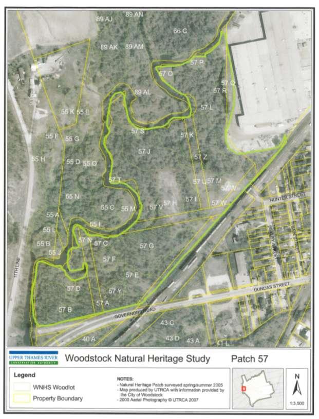
86 t 86
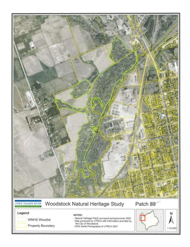
87 87
88 Appendix E-2. Burgess/Standard Tube Parks, Vegetation Community Details (see Appendix E-1 maps) Patch ELC Size Age Topography Dominant Species (Features) (ha) 55a SWD M lowland Slv maple, willow wh elm, bl walnut 55b FOD Y lowland Man maple, willow, wh elm 55c FOD Y lowland Man maple 55d CUW P lowland Man maple, bl walnut 55e FOD Y terrace Bla walnut, bl cherry, hawthorn 55f SWD M lowland Willow, bal poplar, bl walnut 55g SWT P lowland Bl walnut, hawthorns 55h FOD M valleyland Bl walnut, willow, hawthorns 55I CUM j CUM k FOD 0.34 Bal poplar 55L CUM M CUM N CUM O CUM A FOD M lowland Gr ash, man maple 57B SWD M lowland Cottonwood, slv maple 57C FOD M lowland Man maple, gr ash, wh elm, bl oak 57D CUM P lowland Grass 57E CUT P lowland Gr ash, man maple 57F SWD M lowland Willow, Gr. Ash, Man. Maple 57G FOD Y lowland Gr. Ash, Man. Maple 57H CUS P lowland Man. Maple 57I SWD Y lowland Man. Maple, Slv. Maple 57J FOD M lowland Gr. Ash, Slv. Maple, Man. Maple 57K SWD M lowland Willow, Slv. Maple, Cottonwood 57L FOD Y lowland Ma. Maple, Willow 57M CUT P lowland Hawthorn, buckthorn, Bl. Walnut 57N CUM 0.04 lowland 57O CUM 0.11 lowland 57P CUM 0.09 lowland 57Q CUM 0.29 lowland 57R SA 0.13 lowland Shallow Pond 57S CUM 0.05 lowland 57T CUM 0.03 lowland 57U CUM 0.08 lowland 57V SA 0.07 lowland Shallow Pond 57W CUP 0.15 lowland Community Forestry Site 57X CUM 0.51 lowland 57Y SWD M lowland Cottonwood, Slv. Maple 57Z SA 0.08 lowland Shallow Pond 66A FOD Y Terrace Man. Maple 66B FOD Y Valleyland Slv. Maple, Man. Maple 66C A FOD P Valleyland Tr. Aspen 89b CUW P Terrace Bl. Walnut, Man. Maple 89C FOD Y Valleyland Basswood, Bl. Cherry. Sgr. Maple, Bl. Walnut, Wh Ash 88
89 89D SWD Y lowland Willow, man maple, bl walnut 89E SWD M lowland Willow, man maple, bl walnut 89F CUW P valleyland Bl. Cherry, Wh. Ash, Bl.Walnut, Wh.Elm, Man. Maple 89G FOD Y lowland Bl.Cherry, Basswood, Sgr. Maple, Bl. Walnut, Gr. Ash 89H SWD M lowland Slv.Maple, Gr. Ash 89I SWD Y lowland Slv. Maple, Willow, Gr. Ash 89J SWD Y Lowland Slv. Maple, Willow, Man. Maple 89K FOD Y Lowland Bur Oak, Slv.Maple, Gr.Ash, Bl.Walnut, Bl.Cherry, Basswood 89L SWD Y lwoalnd Gr.Ash, Slv.Maple 89M CUS P valleyland Bl.walnut 89N CUW Y valleyland Bl.Walnut, Bl. Locust, bl.cherry 89O MAM P lowland Slv.Maple 89P SWT P Lowland Gr. Ash, Slv.Maple, Man.Maple 89Q SWD Y Lowland Willow 89R SWD M Lowland Willow 89S SWD Y lowland Man.maple, Gr. Ash, Slv. Maple, Wh.Elm 89T SWD M lowland Willow, Slv. Maple, Man. Maple 89U SWD M riverine Willow, Slv. Maple, Man. Maple 89V SWD Y lowland Man.maple, willow, slv. Maple, gr. Ash 89W SWD M lowland Willow, slv. Maple, man maple 89X FOD Y lowland Man. Maple, willow, bl. Walnut, bur oak 89Y SWD M lowland Slv.maple 89Z SWT P lowland Hawthorn, man.maple, red dogwood, nannyberry 89AA MAM P lowland Canary reed grass 89AB CUW P valleyland Bl.cherry, hawthorn, bl. Walnut, man maple, apple 89AC SWD M riverine Willow, man.maple 89AD SWT P terrace Gr ash, bl cherry, bl Walnut 89AE CUM P terrace Grass 89AF SWT P terrace Willow, gr ash, bl cherry 89AG FOD P terrace Tr aspen 89AH SWT P terrace Willow, gr ash, bl cherry 89AI SWD M lowland Willow, man maple 89AJ FOD Y terrace Tr aspen, bal poplar, bl cherry 89AK SWD M lowland Willow 89AL SWD Y riverine Man maple, willow 89AM SWD M lowland Willow, cottonwood, man maple, bur oak, slv Maple 89AN SWD P riverine Willow, manmaple, gr ash 89AO SWD Y tableland Bl walnut 89AP FOD M tableland Sug maple 89AQ FOD Y tableland Bl Walnut, gr ash 89AR CUS P valleyland Wh cedar, gr ash 89AS CUP Y tableland Man maple, wh pine, bl walnut 89AT FOD Y valleyland Man maple, wh ash, bl walnut, tr aspen 89AU FOD M valleyland Wh ash, basswood, bl walnut, bur oak, bl cherry 89AV FOD P terrace Tr aspen 89AW SWD Y lowland Slv maple, willow, man maple 89AX CUM AY FOD AZ CUM BA CUM BB CUM BC CUM BD CUM
90 89BE CUM A CUP3-2 Y tableland Wh pine 100B Fod7 Y tableland Man maple, Wh Ash, Basswood NOTES ELC Ecological Land Classification SWD Deciduous Swamp SWT Deciduous Thicket FOD Deciduous Forest CUW Cultural Woodland CUM - Cultural Meadow CUT Cultural Thicket CUP Cultural Plantation CUS Cultural Savanna MAM Meadow Marsh SA Pond, Submergent Aquatic Size ha (0.5 ha is usually the minimum) Age P (Pioneer), Y (Young), M (Mid-age) Species short forms: Bal poplar balsam poplar Bl walnut black walnut Bl locust black locus Bl cherry black cherry Gr ash green ash Man maple Manitoba maple or Box Elder Slv maple Silver Maple Sug maple Sugar Maple Tr aspen trembling aspen Wh ash White Ash Wh Pine White pine Source: Woodstock Natural Heritage Inventory Vegetation Units (55, 57, 62, 66, 89, 100). 90
91 Appendix E-3. Wetland Plant List (Source: 2009 MNR Wetland Evaluation) Scientific Name Common Name Acer negundo Manitoba Maple Acer nigrum Black Maple Acer saccharinum Silver Maple Agrimonia gryposepala Agrimony Alliaria petiolata * Garlic Mustard * Ambrosia artemisiifolia Common Ragweed Amphicarpa bracteata Hog Peanut Anemone canadensis Canada Anemone Angelica atropupurea Great Angelica Asclepias incarnata Swamp Milkweed Bidens cernua Nodding Bur Marigold Bidens spp. Bidens Bidens spp. Beggar Ticks Boehmeria cylindrica False Nettle Bromus ciliatus Fringed Brome Calamagrostis canadensis Canada Blue Joint Calystegia speium ssp. Angulata * Hedge Bindweed * Cardamine pensylvanica Pennsylvania Bitter Cress Carex grisea Grey Sedge Carex spp. sedge Celtis occidentalis Hackberry Cephalanthus occidentalis Buttonbush Ceratophyllum demersum Hornwort or Coontail Cicuta maculata Water Hemlock Circaea canadensis Enchanter's Nightshade Clyceria striata Fowl Manna Grass Cornus amomum ssp. oblique Silky Dogwood Cornus racemosa Gray Dogwood Cornus stolonifera Red-osier Dogwood Crataegus spp. Hawthorn Echinocystis lobata Wild Mock-cucumber Elodea canadensis Common Waterweed Equisetum spp. Horsetail Erigeron philadelphicus Philadelphia Fleabane Eupatorium spp. Joe-Pye Weed Eutrochium maculatum var. maculatum Spotted Joe-Pye Weed Fraxinus nigra Black Ash 91
92 Fraxinus pennsylvanica Green Ash Galium sp. Bedstraw Galium triflorum Fragrant Bedstraw Geranium maculatum wild geranium Geum canadense White Avens Heracleum maximum Cow-parsnip Hesperis matronalis * Dame's Rocket * Impatiens capensis Spotted Jewelweed Impatiens pallida Pale Jewelweed Impatiens spp. Jewelweed Iris versicolour Harlequin Blue Flag Juglans nigra Black Walnut Juncus effusus Soft Stem Rush Juniperus virginiana Eastern Redcedar Leersia oryzoides Rice cut grass Lemna spp. Duckweed Lonicera spp. Honeysuckle Lonicera tatarica * Tartarian Honeysuckle * Lycopus americanus Water Horehound Lysimachia nummularia * Moneywort Lysimachia terrestris Yellow Loosestrife Mentha arvensis Field Mint Onoclea sesibilis Sensitive Fern Oxalis stricta Wood Sorrel Parthenocissus quinquefolia Virginia Creeper Phalaris arundinaceae Reed Canary Grass Physocarpus opulifolius Ninebark Pilea pumila Canada Clearweed Polygonum amphibium Water Smartweed Polygonum hydropiper Water Pepper Polygonum ssp. Smartweed Populus deltoides ssp. Deltoides Eastern Cottonwood Populus tremuloides Trembling Aspen Potamogeton crispus * Curly-leaved Pondweed * Prunella vulgaris ssp. vulgaris * Heal-all, Self-heal * Quercus bicolor Swamp White Oak Quercus macrocarpa Bur Oak Rhamnus spp. * Buckthorn * Ribes americanum Black Currant Ribies spp. gooseberry Rubus occidentalis Black Raspberry 92
93 Rubus spp. raspberry Rumex sp. * dock * Sagittaria latifolia Arrowhead Salix eriocephala Heart-leaved Willow Salix euxina * Crack Willow * Salix nigra Black Willow Salix petiolaris Meadow Willow Sicyos angulatus One-seeded Bur Cucumber Sium suave Water-parsnip Solanum dulcamara * Bittersweet Nightshade * Solidago spp. goldenrod Sparganium americanum American Burreed Spiraea latifolia Meadowsweet Symphotrichum lateriflorus Calico Aster Symplocarpus foetidus Skunk Cabbage Sypmphotrichum spp. aster Thalictrum spp. Meadow-rue Toxicodendron radicans Poison Ivey Tussilago farfara * Colt's-foot * Typha spp. cattail Ulmus americana White Elm Urtica dioica Stinging Nettle * Urtica spp. Nettle Verbena hastata Blue Vervain Verbena urticifolia White Vervain Viola spp. violets Vitis aestivalis Summer Grape Vitis riparia Riverbank Grape Alien or Non-native species are denoted with an asterisk (*) 93
94 Appendix E-4. Botanical Inventory of Field 1, June 14 th, 2011 Scientific Name Acer negundo * Achillea millefolium * Asclepias syriaca Aster urophyllus Cerastium fontanim * Chrysanthemum leucanthemum * Cirsium vulgare * Cornus spp. Daucus carota * Erigeron annus * Geum aleppicum Geum canadensis Hieracium vulgatum * Hyperiucm perforatum * Juglans nigra Lychnis alba * Medicago lupulina * Melilotus spp. * Parthenocissus quinquefolia Potentilla recta * Prunus serotina Rumex crispus * Rubus idaeus Silene vulgaris * Solidago altisima Sonchus arvensis * Taraxicum officinalis* Trifolium pretense* Verbascum Thapsus * Vicia cracca * * Non-native species Common Name Manitoba Maple (saplings) Yarrow Common Milkweed Arrow-leaved Aster Mouse-ear Chickweed Oxeye Daisy Bull Thistle Dogwoods Queen Anne s Lace Annual or Daisy Fleabane Yellow Avens White Geum Common Hawkweed St. Johnswort Black Walnut (saplings) White Campion Black Medic Sweet Clovers Virginia Creeper Rough-fruited Cinquefoil Black Cherry (saplings) Curled Dock Wild Red Raspberry or Thimbleberry Bladder Campion Tall Goldenrod Field Sow Thistle Dandelion Red Clover Common Mullein Cow Vetch Birds: American Goldfinch, Common Yellowthroat, Chipping Sparrow, Field Sparrow, Song Sparrow, Tree Swallow (nesting in box), Wren Other Viceroy Butterfly, Monarch Butterfly, White Dragonfly Inventory by Brenda Gallagher, Vegetation Specialist and Cathy Quinlan, Terrestrial Biologist, UTRCA. 94
95 Appendix F-1. Bird Sightings SG (Scott Gillingwater), BG (Brenda Gallagher), CQ (Cathy Quinlan) of UTRCA and MNR (Ministry of Natural Resources wetland evaluation team) Bird Species Source Bird Species Source 1. DUCKS, GEESE, SWANS 22. JAYS, CROWS, RAVENS Redhead SG Blue Jay SG Common Merganser SG Red-headed Merganser SG 23. LARKS Hooded Merganser Canada Goose SG 24. SWALLOWS SG Mallard SG Tree Swallow SG Bufflehead SG Barn Swallow SG Northern Shoveler SG Cliff Swallow SG Green Winged Teal SG Northern Roughwinged Swallow SG American Wigeon SG Mute Swan SG 25. CHICKADEES AND ALLIES Wood Duck SG Black-capped Chickadee SG White Breasted Nuthatch 2. GALLINACEOUS BIRDS Red Breasted Nuthatch SG 3. LOONS AND GREBES Brown Creeper SG 4. PELICANS, CORMORANTS, ANHINGAS 26. WRENS 5. BITTERNS, HERONS, ALLIES Wren SG Great Blue Heron SG, CQ Green Heron SG 27. KINGLETS & GNATCATCHERS Golden Crowned Kinglet SG 6. VULTURES Ruby Crowned Kinglet SG Turkey Vulture SG 28. THRUSHES 7. HAWKS, KITES, EAGLES, FALCONS Eastern Bluebird SG Coopers Hawk SG Veery SG Red-tailed Hawk SG Wood Thrush SG Rough legged Hawk SG American Robin SG American Kestrel SG 29. MOCKINGBIRDS, THRASHERS 8. RAILS, COOTS, GALLINULES, CRANES Grey Catbird SG 9. PLOVERS, SANDPIPERS, ALLIES Greater Yellowlegs SG 30. STARLINGS Killdeer SG European Starling SG Spotted Sandpiper SG Semi-palmated Plover SG 32 WAXWINGS American Woodcock SG Cedar Waxwing SG SG 95
96 10.GULLS AND TERNS 34.WOOD-WARBLERS Ring-billed Gull SG Yellow Warbler SG, MNR Herring Gull SG Magnolia Warbler SG Black and White Warbler SG 11. MURRES Blackburnian Warbler SG Black-throated Green Warbler SG 12. PIGEONS AND DOVES American Redstart SG Rock Dove (Pigeon) SG Connecticut Warbler SG Mourning Dove SG Ovenbird SG Yellow Rumped Warbler SG 13. CUCKOOS Chestnut sided Warbler SG Yellow Billed Cuckoo SG, BG Common Yellowthroat BG 14. OWLS 35. SPARROWS Barred Owl SG Song Sparrow SG, BG Great Horned owl SG American Tree Sparrow SG White Throated Sparrow SG 15. GOATSUCKERS White Crowned Sparrow SG Common Nighthawk (Special Concern) SG Field Sparrow BG Chipping Sparrow MNR 16. SWIFTS AND HUMMINGBIRDS Swamp Sparrow SG Chimney Swift (Threatened) SG Eastern Towhee SG Ruby throated Hummingbird SG Dark Eyed Junco SG 17. KINGFISHERS 36. TANAGERS, CARDINALS, ALLIES Belted Kingfisher SG Rose-breasted Grosbeak SG Scarlet Tanager SG 18. WOODPECKERS Northern Cardinal SG Northern Flicker SG Downy Woodpecker SG 37. BLACKBIRDS Hairy Woodpecker SG Baltimore Oriole SG Yellow-bellied Sapsucker SG Brownheaded Cowbird SG 96 Red winged Blackbird 19. TYRANT FLYCATHERS Common Grackle SG Eastern Wood Pewee SG, MNR Great Crested Flycatcher 38. FINCHES SG House Finch SG 20. SHRIKES American Goldfinch SG Northern Shrike SG 39. OLD WORLD SPARROWS 21. VIREOS House Sparrow SG Red eyed Vireo SG TOTAL 92 species SG
97 Appendix F-2. Reptile, Amphibian and Mammal Sightings Reptiles Species Source Notes Milk Snake SG Two along edge of upper trail Snapping Turtle SG About 10 in the river and adjacent floodplain wetlands and nesting on upper trail Midland Painted Turtle SG About 5 in floodplain wetlands and nesting on upper trail Eastern Garter Snake SG, CQ About 20 on upper and lower trails and in adjacent retired fields and open woodlots Northern Brown Snake SG Two along edge of upper trail Amphibians Species Source Notes Leopard Frog SG Many along trail edges, river edge, and floodplain wetlands Green Frog SG, MNR Many along floodplain wetlands and river edge Spring Peeper SG Many along trail edges in woods American Toad SG, CQ Many found in multiple areas Northern Red-backed Salamander SG Upland forest area near road Mammals Species Source Notes White Tailed Deer SG, CQ Yarding in winter; up to 26 observed together Red Fox Beaver Muskrat Virginia Opossum Coyote Eastern Cottontail Grey Squirrel Red Squirrel Eastern Chipmunk Star-nosed Mole Vole Deer Mouse House Mouse Short-tailed Shrew American Mink Racoon SG SG, CQ SG SG SG SG SG, CQ SG SG SG SG SG SG CQ SG SG Domestic Cat SG SG (Scott Gillingwater), BG (Brenda Gallagher), CQ (Cathy Quinlan) of UTRCA and MNR (Ministry of Natural Resources wetland evaluation team) 97
98 Field 1 - Meadow Slowly Evolving to Forest Timing Year 1 Site Preparation Work / Task Appendix G-1. Naturalization Plan Details for Field 1 Expenses (pd=person day, chem=chemical) Total Cost Estimate Early Spring Brush saw the taller clumps of Manitoba Maple (MM) seedlings 3 pd $1,100 Early Spring Cut down 1/3 of the seed-bearing MM in the ravine and treat stumps. Or, EZ-JECT standing trees for about half the cost. 3 pd + chem $1,300 Mid Spring Brush hog field Contract out $3,000 Summer Spot spray MM re-sprouts with herbicide (first time) 1 pd + chem $500 Fall Spot spray MM re-sprouts with herbicide (second time) 1 pd + chem $500 Tree Planting Mid Spring Mid Spring and Fall Plant a windbreak on eastern border of field (~250 m long) to buffer golf course. UTRCA tree planting crew and includes herbicide spray. Plant nodes of trees/shrubs in eastern half of field using UTRCA Communities for Nature School Program 75 trees x $40 $3,000 2 days Communities for Nature Program $7,000 Year 1 Total $16,400 Year 2 Site Preparation Early Spring Spot spray MM re-sprouts in western field 1 pd + chem $500 Early Spring Chemically kill another third of the large MM in the ravine. 3 pd + chem $1,300 Tree Planting Mid Spring Spade in very large trees along ravine to replace the MMs and restore shade to creek. Or plant large trees for about 2/3 the cost. 10 trees x $500 $5,000 Mid Spring and Fall Plant nodes of trees and shrubs in eastern half of field using UTRCA Communities for Nature School Program (as above) 2 days Communities for Nature Program $7,000 Spring Host Arbour Day events here to provide additional opportunities to do tree planting Year 2 Total $13,800 Year 3 Early Spring Chemically kill last third of seed-bearing MM in ravine. 3 pd + chem $1,300 Early Spring Plant or spade in last of the trees along the ravine. 10 trees x $500 $5,000 Year 3 Total $6,300 THREE YEAR TOTAL $36,500 n/a 98
99 Appendix G-2. Naturalization Plan Details for Field 2. Field 2 - Meadow Slowly Evolving to Shrubland then Forest Timing Work / Task Year 1 Expenses (p=person, d=day, chem=chemical) Total Cost Estimate Early Spring Brush saw the taller clumps of Manitoba Maple (MM) seedlings 3 pd $1,500 Mid Spring Brush hog entire field (9 ac) $3,000 Summer to Fall Spot spray MM regrowth once in summer and once in fall $1,000 Fall Plant shrubs and trees with school groups 1 Day $3,500 Year 1 Total $9,000 Year 2 spring Plant shrubs and trees with school groups 2 days $7,000 Year 2 Total $7,000 TWO YEAR TOTAL $16,000 99
100 Appendix G-3. Naturalization Plan Details for Field 3 Field 3 Meadow Slowly Evolving to Shrubland and Forest Timing Year 1 Early Spring Summer Work / Task Brush saw the taller clumps of Manitoba Maple (MM) seedlings and Expenses (p=person, d=day, chem=chemical) Total Cost Estimate 3 pd $1,500 brush hog the entire field $2,000 Spot spray the Manitoba Maple re-sprouts and saplings with herbicide 1 pd + chemical $500 Year 1 Total $4,000 Year 2 Spring With school groups, plant notes of wildlife shrubs throughout field. 1 day Communities for Nature Program $3,500 Fall With school groups, plant notes of wildlife shrubs throughout field. (potted stock more expensive) 1 day Communities for Nature Program $4,000 Year 2 Total $7,500 Year 3 Spring With school groups, plant notes of wildlife shrubs throughout field. 1 day Communities for Nature Program $3,500 Year 3 Total $3,500 THREE YEAR TOTAL $15,
101 Appendix G-4. Naturalization Plan Details for Field 4 Field 4 - Part Tallgrass Prairie and Part Shrubland Timing Work / Task Year 1 Prairie Preparation Expenses (p=person, d=day, chem=chemical) Total Cost Estimate Spring Brush hog the field Custom $3,000 Late spring Prairie Site preparation (plow, till, mulch). Custom $2,000 Early summer Later summer Prairie: After green-up, spray the plot with Roundup (1 st application) $1,500 Prairie: Till $1,000 Fall After green-up, spray the plot with Roundup (2 nd application) $1,500 Year 1 Total $9,000 Year 2 Early Spring Seed by machine native prairie species custom $6,500 Late Spring After green-up, spray plot with Roundup (3 rd application) custom $1,500 Mid Spring Plant a windbreak on western border of the field (~250 m long) to buffer the back yards. UTRCA tree planting crew and includes herbicide spray. 75 trees x $40 $3,000 Year 2 Total $11,000 Year 3 Late Spring or fall Shrub planting with school groups 2 days community forestry $7,500 summer Mow prairie to keep weeds down $500 Year 3 Total $8,000 THREE YEAR TOTAL $28,000 Ongoing Work: Conduct a prescribed burn on the prairie every 3-5 years or mow/lightly plow it at the same frequency to keep woody plants from establishing. 101
102 Appendix G-5. Legislation Governing Pesticide Use Legislation governing pesticide use: The Ontario Pesticides Act and Ontario Regulation 63/09 provide natural resources, forestry and agricultural exceptions which may allow chemical control of invasive plants on your property. Other exceptions under the Act include golf courses, and for the promotion of public health and safety. Natural Resources Exception A natural resources exception exists for the use of prohibited pesticides to manage, protect, establish or restore a natural resource. This exception allows the use of certain prohibited herbicides for control of invasive plants on your property provided your project meets specific conditions and you obtain the necessary approvals. If your project meets the natural resources criteria specified in section 33 of Ontario Regulation 63/09 and includes the use of pesticides in accordance with Integrated Pest Management principles outlined in the BMP guide you will need to contact the Ontario Ministry of Natural Resources ( to obtain a written letter of opinion from the MNR Regional or Branch Director. Forestry Exception If honeysuckle is within a forest*, chemical control may fall under the exception for forest management, and a letter of opinion may not be required. Class 9 pesticides can be used under the forestry* exception to protect trees from pests and to control competing vegetation. *O. Reg. 63/09 defines forest and forestry as: Forest means a treed area of land that is one hectare in size or larger and is not used for producing an agricultural crop as part of an agricultural operation. Forestry means activities relating to any of the following: harvesting, renewing, maintaining or establishing a forest, protecting forest resources derived from a forest, and accessing a forest for these purposes. Refer also to the Ministry of Environment s factsheet titled Pesticides Act and Ontario Regulation 63/09 Private Land and Woodlot Owners April Anyone using a pesticide is responsible for complying with all federal and provincial legislation. Most nondomestic (i.e. commercial, restricted etc.) herbicides can only be applied by licensed exterminators. For more information, refer to the Ontario Pesticides Act and Ontario Regulation 63/09 (available on or contact the Ontario Ministry of the Environment ( Source: Tassie, Danielle Invasive Bush Honeysuckles (Lonicera spp.) Best Management Practices in Ontario. Ontario Invasive Plant Council, Peterborough, ON. Draft November Peterborough, Ontario. 102

103 Appendix H. Map of Burgess/Standard Tube Park within the 2007 City of Woodstock Trail Master Plan Map 103

104 Appendix I. Westminster Ponds/Pond Mills ESA Brochure (page 1 of 2) 104

105 Appendix I continued 105
Prepared by Cathy Quinlan & Brad Hertner Upper Thames River Conservation Authority. For the City of Woodstock
 Prepared by Cathy Quinlan & Brad Hertner Upper Thames River Conservation Authority For the City of Woodstock Burgess Park and Standard Tube Parks in the west end of Woodstock Pittock Reservoir Along the
Geoscape Toronto The Oak Ridges Moraine Activity 2 - Page 1 of 10 Information Bulletin
 About 13,000 years ago as the Laurentide Ice Sheet melted, glacial meltwater accumulated between the ice sheet and the Niagara Escarpment. This formed a lake basin into which gravel and sand were deposited.
CRAZY HORSE TRAIL GUIDE
 CRAZY HORSE TRAIL GUIDE Abridged Version: July 2016 This is a short form of our interpretive trail guide for the Crazy Horse Trail. The full version of the guide has a more detailed description of the
Conservation Area Management Statement
 Conservation Area Management Statement Miller Creek Wildlife Area Resolution #: Approval: Issue Date: Date of Last Revision: Table of Contents 1. Purpose....... 1 2. Property Description...... 1 2.1. Legal
3.0 EXISTING PARK & RECREATION SPACE
 3.0 EXISTING PARK & RECREATION SPACE TOWN PARK & RECREATION SPACE An inventory of current parks and recreation area in the Town of Cedarburg is shown in Table 3. These areas total roughly 381.89 acres.
ETOBICOKE CREEK NORTH TRAIL PROJECT. May 18, 2017 at Michael Power High School 105 Eringate Drive, Etobicoke ON M9C 3Z7
 ETOBICOKE CREEK NORTH TRAIL PROJECT May 18, 2017 at Michael Power High School 105 Eringate Drive, Etobicoke ON M9C 3Z7 1 Purpose of Open House The purpose of today s open house is to present the design
Understanding user expectations And planning for long term sustainability 1
 Understanding user expectations And planning for long term sustainability 1 What is a natural surface trail? It can be as simple has a mineral soil, mulched or graveled pathway, or as developed as elevated
Town of Oakfield Agricultural and Farmland Protection Plan
 SECTION III COMMUNITY OVERVIEW A. Regional Setting / Location The Town of Oakfield is located in the northwestern portion of Genesee County. Located west of New York's Finger Lakes, the Town is uniquely
3.0 LEARNING FROM CHATHAM-KENT S CITIZENS
 3.0 LEARNING FROM CHATHAM-KENT S CITIZENS An important aspect in developing the Chatham-Kent Trails Master Plan was to obtain input from stakeholders and the general public. Throughout the course of the
Port Bruce. Interim Management Statement
 Port Bruce Interim Management Statement Port Bruce Interim Management Statement August 3, 1999 This Port Bruce Provincial Park Interim Management Statement provides direction for the custodial management
THOMAS A. SWIFT METROPARK Introductions History Present Conditions Future Development Plans Implementation Strategies Statistics
 THOMAS A. SWIFT METROPARK Introductions History Present Conditions Future Development Plans Implementation Strategies Statistics Introduction As an open meadow park positioned along the Mahoning River,
Segment 2: La Crescent to Miller s Corner
 goal of the USFWS refuges is to conserve, protect and enhance fish, wildlife and plants and their habitats for the continuing benefit of the American people. Refuge lands are used largely for fishing,
THAT the Board approve the final proposed concept plan for the Jericho Marginal Wharf site as shown in Figure C-4 of Appendix C.
 Date: January 17, 2012 TO: Board Members Vancouver Park Board FROM: General Manager Parks and Recreation SUBJECT: Jericho Marginal Wharf Phase 2 Concept Plan RECOMMENDATION THAT the Board approve the final
Establishing a National Urban Park in the Rouge Valley
 STAFF REPORT ACTION REQUIRED Establishing a National Urban Park in the Rouge Valley Date: March 29, 2012 To: From: Wards: Reference Number: Executive Committee Deputy City Manager, Cluster B All p:\2012\cluster
Welcome to the future of Terwillegar Park a Unique Natural Park
 Welcome to the future of Terwillegar Park a Unique Natural Park 1 Introduction The Terwillegar Park Concept Plan study will develop an overall concept plan, management objectives and development guidelines
MORGAN CREEK GREENWAY Final Report APPENDICES
 APPENDICES MORGAN CREEK GREENWAY Appendix A Photos of Existing Conditions in Trail Corridor Photos of existing conditions Main trail corridor - February 2009 Photos of existing conditions south bank Morgan
2.0 Physical Characteristics
 _ 2.0 Physical Characteristics 2.1 Existing Land Use for the Project The site is comprised of approximately 114 acres bounded by Highway 101 to the north, the existing town of Los Alamos to the east, State
MASTER PLAN EXECUTIVE SUMMARY
 Biscuit Run State Park Scottsville Road (State Route 20) Charlottesville, VA 22902 Biscuit Run State Park MASTER PLAN EXECUTIVE SUMMARY Department of Conservation and Recreation Division of Planning and
DIXIE HIGHWAY Region of Peel NAI Area # 1304, 1320, 2449, 2625, 3961
 DIXIE HIGHWAY 407 1 Region of Peel NAI Area # 1304, 1320, 2449, 2625, 3961 Toronto and Region Conservation Authority City of Brampton Size: 36 hectares Watershed: Etobicoke Creek Con 4 E, Lots 13, 14 Ownership:
Watchorn Provincial Park. Management Plan
 Watchorn Provincial Park Management Plan 2 Watchorn Provincial Park Table of Contents 1. Introduction... 3 2. Park History... 3 3. Park Attributes... 3 3.1 Natural... 4 3.2 Recreational... 4 3.3 Additional
Blue River Trail Master Plan JSA to Town Hall June 2004
 Blue River Trail Master Plan JSA to Town Hall June 2004 Prepared for: Silverthorne Town Council Silverthorne SPORT Committee Department of Recreation and Culture Silverthorne Public Works Silverthorne
Sasagiu Rapids Provincial Park. Draft Management Plan
 Sasagiu Rapids Provincial Park Draft Management Plan 2 Sasagiu Rapids Provincial Park Table of Contents 1. Introduction... 3 2. Background and Park Attributes... 3 2.1 Park History.... 3 2.2 Natural Features...
White Mountain National Forest Saco Ranger District
 United States Department of Agriculture Forest Service White Mountain National Forest Saco Ranger District 33 Kancamagus Highway Conway, NH 03818 Comm: (603) 447-5448 TTY: (603) 447-3121 File Code: 1950
SUMMER VILLAGE OF SILVER SANDS. Municipal Development Plan
 SUMMER VILLAGE OF SILVER SANDS Municipal Development Plan Bylaw 253-2014 Adopted August 22, 2014 Summer Village of Silver Sands Municipal Development Plan Bylaw No. 253-2014 Page 2 1 INTRODUCTION 1.1 SETTING
2. Goals and Policies. The following are the adopted Parks and Trails Goals for Stillwater Township:
 D. PARKS AND TRAILS 1. Introduction Stillwater Township s population is relatively low, with most residents living on rural residences on large lots. The need for active park space has been minimal in
Yard Creek Provincial Park. Management Plan
 Yard Creek Provincial Park Management Plan Draft January 2010 Yard Creek Provincial Park Management Plan Approved by: telàlsemkin/siyam/chief Scott Benton Bill Williams Squamish Executive Director ation
APPENDIX D: SUSTAINABLE TRAIL DESIGN. APPENDICES Town of Chili Parks and Recreation Master Plan Update
 APPENDIX D: SUSTAINABLE TRAIL DESIGN APPENDICES Town of Chili Parks and Recreation Master Plan Update Sustainable Trail Construction Sustainable trails are defined by the US Forest Service as trails having
Clearwater Lake Provincial Park. Draft Management Plan
 Clearwater Lake Provincial Park Draft Management Plan Clearwater Lake Provincial Park Draft Management Plan Table of Contents 1. Introduction... 3 2. Park History... 4 3. Park Attributes... 4 3.1 Location/Access...4
Approval Statement. Brian Pfrimmer, Central Zone Manager Ontario Parks
 Approval Statement I am pleased to approve this Interim Management Statement for Dividing Lake Provincial Nature Reserve. This Nature Reserve contains biological features of provincial significance and
Criddle/Vane Homestead Provincial Park. Management Plan
 Criddle/Vane Homestead Provincial Park Management Plan 2 Criddle/Vane Homestead Provincial Park Table of Contents 1. Introduction... 3 2. Park History.... 3 3. Park Attributes.... 4 3.1 Natural.... 4 3.2
National Forests and Grasslands in Texas
 United States Department of Agriculture Forest Service National Forests and Grasslands in Texas Sam Houston NF 394 FM 1375 West New Waverly, Texas 77358 Phone 936-344-6205 Dear Friends, File Code: 1950
Gatwick Stream Riverside Garden Park, Horley
 Gatwick Stream Riverside Garden Park, Horley An Advisory Visit by the Wild Trout Trust January 2014 1 1. Introduction This report is the output of a Wild Trout Trust visit to the Gatwick Stream in Horley,
EAST DON TRAIL ENVIRONMENTAL ASSESSMENT. Community Liaison Committee Meeting #3 July 15, :30 to 8:30 pm Flemingdon Park Library
 EAST DON TRAIL ENVIRONMENTAL ASSESSMENT Community Liaison Committee Meeting #3 July 15, 2013 6:30 to 8:30 pm Flemingdon Park Library Agenda 1. Welcome 2. Housekeeping and Updates a) Housekeeping b) CLC
Bradley Brook Relocation Project. Scoping Notice. Saco Ranger District. United States Department of Agriculture Forest Service
 Bradley Brook Relocation Project United States Department of Agriculture Forest Service Scoping Notice White Mountain National Forest February 2011 For Information Contact: Jenny Burnett White Mountain
ANAGEMENT. LAN November, 1996
 M ANAGEMENT P LAN November, 1996 for Paul Lake Provincial Park Ministry of Environment, Lands and Parks BC Parks Department Paul Lake Provincial Park M ANAGEMENT P LAN Prepared by BC Parks Kamloops Area
Mt. Hood National Forest
 United States Department of Agriculture Forest Service Mt. Hood National Forest Zigzag Ranger District 70220 E. Highway 26 Zigzag, OR 97049 503-622-3191 Fax: 503-622-5622 File Code: 1950-1 Date: June 29,
Rule Governing the Designation and Establishment of All-Terrain Vehicle Use Trails on State Land
 Rule Governing the Designation and Establishment of All-Terrain Vehicle Use Trails on State Land 1.0 Authority 1.1 This rule is promulgated pursuant to 23 V.S.A. 3506. Section 3506 (b)(4) states that an
Criddle/Vane Homestead Provincial Park. Draft Management Plan
 Criddle/Vane Homestead Provincial Park Draft Management Plan 2 Criddle/Vane Homestead Provincial Park Table of Contents 1. Introduction... 3 2. Park History.... 3 3. Park Attributes.... 3 3.1 Natural....
Mackinnon Esker Ecological Reserve Draft - Management Plan
 Mackinnon Esker Ecological Reserve Draft - Management Plan May 2011 Photo Credit: This document replaces the direction provided in the Carp Lake Provincial Park and Protected Area and Mackinnon Esker Ecological
 March 25, 1994 To: Re: MEMO TO FILE MINOR AMENDMENT - PINERY PROVINCIAL PARK MANAGEMENT PLAN The following paragraph from page 5 of the Pinery Provincial Park Management Plan (ISBN 0-7729-0290-9) lnsects
Nakina Moraine Provincial Park. Interim Management Statement. Ontario. Ministry of Natural Resources
 Nakina Moraine Provincial Park Interim Management Statement Ontario Ministry of Natural Resources 1999, Queen's Printer for Ontario Printed in Ontario, Canada Additional copies of this publication can
Marchand Provincial Park. Management Plan
 Marchand Provincial Park Management Plan 2 Marchand Provincial Park Table of Contents 1. Introduction... 3 2. Park History... 3 3. Park Attributes... 4 3.1 Natural... 4 3.2 Recreational... 4 3.3 Additional
FEASIBILITY CRITERIA
 This chapter describes the methodology and criteria used to evaluate the feasibility of developing trails throughout the study areas. Land availability, habitat sensitivity, roadway crossings and on-street
DRAFT. Dorabelle Campground Rehabilitation
 DRAFT Dorabelle Campground Rehabilitation September 2012 1.1 REGIONAL SETTING AND PROJECT LOCATION The Dorabelle Campground is located on the western shore of Shaver Lake in Fresno County, California (Section
Business Item No XXX. Proposed Action That the Metropolitan Council approve the Coon Creek Regional Trail Master Plan.
 Business Item No. 2015-XXX Metropolitan Parks and Open Space Commission Meeting date: July 7, 2015 For the Community Development Committee meeting of July 20, 2015 For the Metropolitan Council meeting
Appendix 3. Greenway Design Standards. The Whitemarsh Township Greenway Plan
 Appendix 3 Greenway Design Standards This chapter discusses two design standards for the greenway types discussed above. First, trail design standards are presented together with trailhead facilities and
EXECUTIVE SUMMARY PROGRAM DEVELOPMENT REPORT PURPOSE EXISTING SETTING EXPANDING PARKLAND
 EXECUTIVE SUMMARY PROGRAM DEVELOPMENT REPORT PURPOSE As the culmination of the first phase of the master planning process, this Program Development Report creates the framework to develop the Calero County
BRACEVILLE NATURE PRESERVE Introductions History Present Conditions Future Development Plans Implementation Strategies Statistics
 BRACEVILLE NATURE PRESERVE Introductions History Present Conditions Future Development Plans Implementation Strategies Statistics Introduction Braceville Nature Preserve is one of MetroParks largest preserves.
Southsea Flooding and Coastal Erosion Risk Management Scheme
 Southsea Flooding and Coastal Erosion Risk Management Scheme Public Consultation Report 3 rd November 29th December 2014 TABLE OF CONTENTS 1 INTRODUCTION... ERROR! BOOKMARK NOT DEFINED. 1.1 Purpose of
Gold Coast. Rapid Transit. Chapter twelve Social impact. Chapter content
 Gold Coast Rapid Transit Chapter twelve Social impact Chapter content Social impact assessment process...235 Existing community profile...237 Consultation...238 Social impacts and mitigation strategies...239
Section II. Planning & Public Process Planning for the Baker/Carver Regional Trail began in 2010 as a City of Minnetrista initiative.
 Section II Planning & Public Process Planning for the began in 2010 as a City of initiative. city staff began discussions with the Park District on the possibility of a north/south regional trail connection
Auburn Trail / Ontario Pathways Trail Connector Feasibility Study Public Information Meeting Wednesday, August 22, 2012
 Auburn Trail / Ontario Pathways Trail Connector Feasibility Study Public Information Meeting Wednesday, August 22, 2012 Purpose of Feasibility Study Purpose Evaluate the feasibility of constructing a multiuse
ROAD AND TRAIL PROJECT APPROVAL
 ROAD AND TRAIL PROJECT APPROVAL www.marincountyparks.org Marin County Parks, 3501 Civic Center Dr, Suite 260, San Rafael, CA 94903 DATE: July 12, 2017 PRESERVE: Gary Giacomini Open Space Preserve PROJECT:
Winnipeg Beach Provincial Park. Draft Management Plan
 Winnipeg Beach Provincial Park Draft Management Plan 2 Winnipeg Beach Provincial Park Table of Contents 1. Introduction... 3 2. Park History... 3 3. Park Attributes... 4 3.1 Natural...4 3.2 Recreational...4
WALKER SWAMP INFORMATION DAY Saturday 23 rd June 2018
 WALKER SWAMP INFORMATION DAY Saturday 23 rd June 2018 Introduction to the Upper Wannon River Floodplain wetlands and the new Walker Swamp Restoration Reserve Mark Bachmann and Greg Kerr, Nature Glenelg
Presentation Overview
 DON NARROWS Historical and Existing Conditions March 29, 2008 Presentation Overview 1. Project Location and Background 2. Historical Context How did the Don Narrows Come to Be? 3. The Today 4. Next Steps
Dungeness Recreation Area County Park Master Plan
 Dungeness Recreation Area County Park Public Outreach Meeting October 10, 2007 Project Overview USFWS Site Dungeness Recreation Area County Park Meeting Objectives: Re-Introduce project; provide status
Rating: 5.0 (scale of 1-10)
") 95 Community Trail System Groundcover: 2-metre paved path, 1- metre grass buffer on either side. Location: Fort St. John Ownership: City of Fort St. John Rating: 5.0 (scale of 1-10) Strategic value: Linear
95 Community Trail System Groundcover: 2-metre paved path, 1- metre grass buffer on either side. Location: Fort St. John Ownership: City of Fort St. John Rating: 5.0 (scale of 1-10) Strategic value: Linear
2.1 Physical and Biological Description Matabitchuan River Watershed
 2.1 Physical and Biological Description Watershed 2.1.1 Physical Description The system watershed has a total area of about 933 km 2 and is a tributary system to Lake Temiskaming and the Ottawa River Drainage
Flow Stand Up Paddle Board Parkway Plan Analysis
 Regional Parks Department Jeffrey R. Leatherman, Director County of Sacramento Divisions Administration Golf Leisure Services Maintenance Rangers Therapeutic Recreation Services Flow Stand Up Paddle Board
Northeast Quadrant Distinctive Features
 NORTHEAST QUADRANT Northeast Quadrant Distinctive Features LAND USE The Northeast Quadrant includes all the area within the planning area that is east of Interstate 5 and to the north of State Route 44.
Whitemouth Falls Provincial Park. Draft Management Plan
 Whitemouth Falls Provincial Park Draft Management Plan Whitemouth Falls Provincial Park Draft Management Plan Table of Contents 1. Introduction... 3 2. Park History... 3 3. Park Attributes... 4 3.1 Natural...
Wallace Lake Provincial Park. Management Plan
 Wallace Lake Provincial Park Management Plan 2 Wallace Lake Provincial Park Table of Contents 1. Introduction... 3 2. Park History... 3 3. Park Attributes... 4 3.1 Natural... 4 3.2 Recreational... 4 4.
MANAGEMENT DIRECTION STATEMENT June, 1999
 Thompson River District MANAGEMENT DIRECTION STATEMENT June, 1999 for Roche Lake Provincial Park Ministry of Environment Lands and Parks BC Parks Division Table of Contents I. Introduction A. Setting
PSP 75 Lancefield Road. Northern Jacksons Creek Crossing Supplementary Information
 PSP 75 Lancefield Road Northern Jacksons Creek Crossing Supplementary Information September 2017 The northern crossing of Jacksons Creek proposed within the Lancefield Road PSP is a key part of the ultimate
Committee Report. Community Development Committee For the Metropolitan Council meeting of August 12, Business Item No.
 Committee Report Business Item No. 2015-168 Community Development Committee For the Metropolitan Council meeting of August 12, 2015 Subject: Coon Creek Regional Trail Master Plan, Anoka County Proposed
KANANASKIS COUNTRY PROVINCIAL RECREATION AREAS MANAGEMENT PLAN DRAFT TERMS OF REFERENCE - November 20, 2007
 KANANASKIS COUNTRY PROVINCIAL RECREATION AREAS MANAGEMENT PLAN DRAFT TERMS OF REFERENCE - November 20, 2007 BACKGROUND There are 42 Provincial Recreation Areas (PRAs) within Kananaskis Country located
Pembina Valley Provincial Park. Draft Management Plan
 Pembina Valley Provincial Park Draft Management Plan 2 Pembina Valley Provincial Park Table of Contents 1. Introduction... 3 2. Park History... 3 3. Park Attributes... 3 3.1 Natural... 3 3.2 Recreational...
Appendix A Appendix A (Project Specifications) Auk Auk / Black Diamond (Trail 44) Reroute
 Auk Auk / Black Diamond (Trail 44) Reroute") Appendix A (Project Specifications) Auk Auk / Black Diamond (Trail 44) Reroute I. Proposed Action: This project proposes to reroute approximately 1,800 feet of a 50 inch wide trail, off of private property
Appendix A (Project Specifications) Auk Auk / Black Diamond (Trail 44) Reroute I. Proposed Action: This project proposes to reroute approximately 1,800 feet of a 50 inch wide trail, off of private property
Header i
 Header i 048285014.10 Header Sub Title Body Text here. Body text here. Body text here. Section 1... 1 Executive Summary... 1 Opportunities and Constraints... 3 Overall Opportunities and Constraints Map
Region 1 Piney Woods
 Region 1 Piney Woods Piney Woods 1. This ecoregion is found in East Texas. 2. Climate: average annual rainfall of 36 to 50 inches is fairly uniformly distributed throughout the year, and humidity and temperatures
The Frank Church River of No Return Wilderness
 ALLIANCE FOR WILDERNESS EDUCATION AND STEWARDSHIP PO Box 2667, Bellingham, WA 98227-2667 Tele: 360-927-1804 Fax: 360-527-9679 bradt@wildernessalliance.org www.wildernessalliance.org STEWARDS OF AMERICA
Pinellas County Environmental Lands
 Pinellas County Environmental Lands In addition to traditional parks and recreation facilities, Pinellas County owns and manages a system of environmental lands that provides specialized resource-based
Park-specific management and policies Wainuiomata Recreation Area
 Park-specific management and policies Wainuiomata Recreation Area 6.8 Wainuiomata Recreation Area 6.8.1 Legal status Title held: Legislative status: Wellington Regional Council Administered under Local
Arrangements for the delivery of minor highway maintenance services by Town and Parish Councils
 Arrangements for the delivery of minor highway maintenance services by Town and Parish Councils Cabinet Date of Meeting 8 March 2017 Officer Cllr Peter Finney, Cabinet Member for Environment, Infrastructure
Environment and Natural Resources Trust Fund 2019 Request for Proposals (RFP)
") Environment and Natural Resources Trust Fund 2019 Request for Proposals (RFP) Project Title: Glacial Edge Trail and Downtown Pedestrian Bridge Category: G. Land Acquisition for Habitat and Recreation ENRTF
Environment and Natural Resources Trust Fund 2019 Request for Proposals (RFP) Project Title: Glacial Edge Trail and Downtown Pedestrian Bridge Category: G. Land Acquisition for Habitat and Recreation ENRTF
Welcome KROSNO CREEK DIVERSION PROJECT CLASS ENVIRONMENTAL ASSESSMENT
 Welcome KROSNO CREEK DIVERSION PROJECT PUBLIC INFORMATION CENTRE # 1 Tonight s Presentation Study Overview Background Existing Conditions Alternative Solutions Preliminary Preferred Solution Next Steps
TOWPATH MOWING GUIDELINES
 TOWPATH MOWING GUIDELINES 24 September 2007 CONTENTS Introduction Scope and Status of Guidelines Influences on the Guidelines Health and Safety Biodiversity INTRODUCTION Towpath management is a key issue
Cooloolabin Dam Recreation Management Discussion Paper. November 2013
 Cooloolabin Dam Recreation Management Discussion Paper November 2013 Contents November 2013... 1 Background... 3 Overview of Cooloolabin Dam... 6 Weed Management... 7 Cultural Heritage... 7 Commercial
2. STAKEHOLDER FEEDBACK // What We Heard
 1. QUARRY ROAD TRAIL // Welcome to the Information Session PROJECT DESCRIPTION WHY WE ARE HERE Quarry Road Trail is a popular commuter trail and recreational area for Calgarians. 1. To report citizen feedback
Chapter eight. Parks and Recreation. Introduction. Crystal Lake Park District
 Chapter eight Parks and Recreation Introduction One of the indicators of quality of life in a city is the parks and recreation system. The City of Crystal Lake is fortunate to have an excellent parks and
APPENDIX F List of Commitments
 APPENDIX F List of Commitments s Table F.1 Standard Mitigation Measures Mitigation Measure MnDOT Specification Number Status Update Description Status Update Utilities Provide early notice to utility operators
Business Item No
 Metropolitan Parks and Open Space Commission Meeting date: February 6, 2018 For the Community Development Committee meeting of February 20, 2018 For the Metropolitan Council meeting of February 28, 2018
POLICY & STRATEGIES The Vancouver Park Board approves major changes in Vancouver parks, including the design and development of parks.
 September 8, 2017 TO: Park Board Chair and Commissioners FROM: General Manager Vancouver Board of Parks and Recreation SUBJECT: Brewers Park and Clinton Park Renewal Concept Plans RECOMMENDATION THAT the
4 VIVA PHASE 2 YONGE STREET - Y2, AND HIGHWAY 7 - H3 CORRIDORS PRELIMINARY ENGINEERING UPDATE
 4 VIVA PHASE 2 YONGE STREET - Y2, AND HIGHWAY 7 - H3 CORRIDORS PRELIMINARY ENGINEERING UPDATE The Rapid Transit Public/Private Partnership Steering Committee recommends the following: 1. The presentation
USDA Forest Service Deschutes National Forest DECISION MEMO. Round Lake Christian Camp Master Plan for Reconstruction and New Facilities
 USDA Forest Service Deschutes National Forest DECISION MEMO Round Lake Christian Camp Master Plan for Reconstruction and New Facilities Jefferson County, Oregon T. 13 S., R. 8 E., Section 16, W.M. Background:
At the time, the portion of the line through Eagle County remains wholly under the ownership of Union Pacific Railroad (UP).
.") Chapter 5 The Railroad Corridor as a Trail Corridor The intent of this chapter is to identify how the rail corridor, if available for lease or purchase in all or part, could be incorporated into the core
Chapter 5 The Railroad Corridor as a Trail Corridor The intent of this chapter is to identify how the rail corridor, if available for lease or purchase in all or part, could be incorporated into the core
Preferred Recreation Recommendations Stemilt-Squilchuck Recreation Plan March 2018
 Preferred Recreation Recommendations Stemilt-Squilchuck Recreation Plan March 2018 Below are the recommended recreation ideas and strategies that package together the various recreation concepts compiled
Classifications, Inventory and Level of Service
 Classifications, Inventory and Level of Service Section 3 Kenmore Park, Recreation and Open Space Plan 1 P a g e Classifications and Inventory Park Classifications Kenmore classifies its parks based upon
Welcome! metrovancouver.org. Aldergrove Regional Park - Management Plan
 Welcome! Aldergrove Regional Park - Management Plan The process to create a Management Plan for Aldergrove Regional Park is underway and we would like your input on the draft Vision, Framework and Concept.
Committee. Presentation Outline
 CW-33-15 11/9/2015 Community and Corporate Services Committee November 10, 2015 1 Presentation Outline Background Vision and Objectives Study Process and Timeline Public and Stakeholder Engagement Organization
October 23, 2017 Council Workshop
 MAPLEWOOD VILLAGE CENTRE AND INNOVATION DISTRICT IMPLEMENTATION PLAN & DESIGN GUIDELINES October 23, 2017 Council Workshop COMMUNITY PLAN Purpose of Council Workshop Highlight What We Heard Phase 3 & Key
Seager Wheeler Lake. Representative Area. -- Concept Management Plan --
 Seager Wheeler Lake Representative Area -- Concept Management Plan -- Saskatchewan Environment and Resource Management January, 1999 Saskatchewan s Representative Areas Network Program The Government of
METROPOLITAN COUNCIL 390 North Robert Street, St. Paul, MN Phone (651) TDD (651)
 TDD (651)") DATE: March 27, 2012 METROPOLITAN COUNCIL 390 North Robert Street, St. Paul, MN 55101 Phone (651) 602-1000 TDD (651) 291-0904 TO: Metropolitan Parks and Open Space Commission FROM: Arne Stefferud, Planning
DATE: March 27, 2012 METROPOLITAN COUNCIL 390 North Robert Street, St. Paul, MN 55101 Phone (651) 602-1000 TDD (651) 291-0904 TO: Metropolitan Parks and Open Space Commission FROM: Arne Stefferud, Planning
Hawke s Bay Regional Parks Network. Pekapeka Regional Park Individual Park Plan
 Hawke s Bay Regional Parks Network Pekapeka Regional Park Individual Park Plan 2015-2024 Hawke s Bay Regional Council 159 Dalton Street Private Bag 6006 Napier 4110 Hawke s Bay New Zealand Telephone: 0800
Proposed Official Plan Amendment 41 to the Region of York Official Plan
 COMMITTEE OF THE WHOLE NOVEMBER 18, 2002 REGION OF YORK OFFICIAL PLAN AMENDMENT 41 THE OAK RIDGES MORAINE CONSERVATION PLAN Recommendation The Commissioner of Planning recommends: 1. That the City of Vaughan
SAN ANTONIO RIVER IMPROVEMENTS PROJECT. April 27, 2009
 SAN ANTONIO RIVER IMPROVEMENTS PROJECT April 27, 2009 1 Project Limits 2 Project Partners City of San Antonio Provides project funding for project amenities (i.e.. Sidewalks, Landscaping, Lighting, etc.)
Bayview Escarpment. Interim Management Statement
 Bayview Escarpment Interim Management Statement Bayview Escarpment Provincial Nature Reserve Interim Management Statement January 15, 1995 REGIONAL DIRECTOR'S APPROVAL STATEMENT This Interim Management
Lake Myra County Park. Wake County, North Carolina Community Forum #2 June 12, 2008
 Lake Myra County Park Wake County, North Carolina Community Forum #2 June 12, 2008 Welcome and Introduction Meeting Agenda Welcome Introductions of Project Team Master Plan Process Community Forum #1 Updates
Chapter 2: Summary of Existing Open Space System
 Chapter 2: Summary of Existing Open Space System In 1976, the Wake County Board of Commissioners established the Wake County Parks and Recreation Department in order to provide park facilities and programs