Bob Marshall Wilderness Complex Limits of Acceptable Change (LAC) Monitoring Period Summary
|
|
|
- Chastity Doyle
- 5 years ago
- Views:
Transcription
 2003-2007 Monitoring")
1 Bob Marshall Wilderness Complex Limits of Acceptable Change (LAC) Monitoring Period Summary
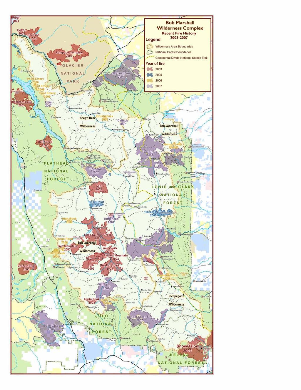
2 Introduction: Recreation management direction for the Bob Marshall Wilderness Complex (BMWC) directs managers to maintain certain recreation opportunities over time. In order to ascertain whether or not these objectives are being met managers, researchers and wilderness users (LAC task force) agreed on several key items or indicators of change that could be measured to assess the overall condition of the wilderness. The limited list of indicators is not intended to provide a comprehensive inventory of wilderness conditions, but rather to alert the manager that change is taking place. The indicators include both biophysical and social components. Each indicator has associated with it a standard that dictates at what point change becomes of concern. The BMWC has been divided into four Opportunity Classes (OC) to provide a range of recreational experiences for wilderness visitors. The Opportunity Classes vary along a spectrum ranging from pristine; little used areas (OCI) to heavily used travel routes (OCIV). It is important to remember that all Opportunity Classes meet or exceed standards for wilderness set in the Wilderness Act and in Forest Service policy. Indicators of change remain constant across all Opportunity Classes. Standards on the other hand, vary from one Class to the next. Resource Areas have been delineated in the BMWC to aid in summarizing data across large landscapes. The Bob Marshall Wilderness Complex, made up of the Great Bear, Scapegoat and Bob Marshall Wilderness Areas and has just completed the 4 th Five-Year monitoring period; The report that follows summarizes the monitoring completed and results of the analysis for this fiveyear period. Complex managers emphasized resource condition monitoring during this period and as a result completed a 94% inventory and re-inventory of all known sites. Additionally, site locations were field validated and database records were updated and verified. Fire was a frequent visitor to the BMWC during the period with over 250,000 acres affected to varying degrees. Significant area and trail closures due to the fire activity were common throughout the complex in 2003 and The summary of resource areas on the following page addresses generalized fire affects as they relate to LAC monitoring. Enjoy! 2
3 Bob Marshall Wilderness Complex Resource Areas - Summary *Note: all acreages and mileages rounded, all numbers from GIS spatial analysis, sites do not include nondiscernable sites, admin sites, approved stock handling sites or historic locations. Resource Area 1 South Fork Flathead Spotted Bear RD Flathead NF Wilderness area: Bob Marshall Wilderness Size: 538,000 acres Approximate miles of trail within area: 570 miles Number of current sites with impact rating-most recent survey: 425 sites Approximate acreage within recent ( ) fire perimeters: 106,150 acres Number of current sites within recent fire perimeters: 116 sites Miles of trail with recent fire perimeters: 148 miles Resource Area 2 Spotted Bear River Spotted Bear RD Flathead NF Wilderness areas: Bob Marshall Wilderness & Great Bear Wilderness Size: 95,000 acres Approximate miles of trail within area: 108 miles Number of current sites with impact rating-most recent survey: 33 sites Approximate area within recent ( ) fire perimeters: 14,520 acres Number of current sites within recent fire perimeters: 3 sites Miles of trail with recent fire perimeters: 12 miles Resource Area 3 Middle Fork Flathead Hungry Horse & Spotted Bear RDs Flathead NF Wilderness areas: Great Bear Wilderness & Bob Marshall Wilderness Size: 366,000 acres Approximate miles of trail within area: 387 miles Number of current sites with impact rating-most recent survey: 382 sites Approximate area within recent ( ) fire perimeters: 30,980 acres Number of current sites within recent fire perimeters: 25 sites Miles of trail with recent fire perimeters: 31 miles Resource Area 4 Rocky Mountain Front Rocky Mountain RD Lewis and Clark NF Wilderness areas: Bob Marshall Wilderness & Scapegoat Wilderness Size: 386,000 acres Approximate miles of trail within area: 458 miles Number of current sites with impact rating-most recent survey: 264 sites Approximate area within recent ( ) fire perimeters: 73,850 acres Number of current sites within recent fire perimeters: 82 sites Miles of trail with recent fire perimeters: 100 miles Resource Area 5 Lincoln Lincoln RD Helena NF Wilderness area: Scapegoat Wilderness Size: 84,000 acres Approximate miles of trail within area: 98 miles Number of current sites with impact rating-most recent survey: 81 sites Approximate area within recent ( ) fire perimeters: 6,970 acres Number of current sites within recent fire perimeters: 2 sites Miles of trail with recent fire perimeters: 9 miles Resource Area 6 Seeley Lake Seeley Lake RD Lolo NF Wilderness area: Scapegoat Wilderness Size: 76,000 acres Approximate miles of trail within area: 82 miles Number of current sites with impact rating-most recent survey: 104 sites Approximate area within recent ( ) fire perimeters: 18,270 acres Number of current sites within recent fire perimeters: 37 sites Miles of trail with recent fire perimeters: 24 miles 3
4 I. TRAIL ENCOUNTERS SOCIAL CONDITIONS A. Indicator: Number of Trail encounters with other parties B. Standard: OCI 80% probability of 0 encounters per day OCII 80% probability of 1 or fewer encounters per day OCIII 80% probability of 3 or fewer encounters per day OCIV 80% probability of 5 or fewer encounters per day C. Monitoring Results Complex-wide by Resource Area: Resource Area OC # of Days Monitored # of Days over Standard Average % Probability 1 I % II % III % IV % 2 I % II % III % 3 I % II % III % IV % 4 I % II % III % IV % 5 I % II % III % IV % 6 I % II % III % IV % BMWC Totals I % II % III % IV % 4
5 D. Charts: Opportunity Class I: Trail Encounters % Probability 120.0% Average % Probability 100.0% 80.0% 60.0% 40.0% 66.7% 87.5% 71.4% 92.9% 100.0% 85.0% 20.0% 0.0% RA1 RA2 RA3 RA4 RA5 RA6 Resource Area Opportunity Class II: Trail Encounters % Probability 120.0% Average % Probability 100.0% 80.0% 60.0% 40.0% 97.6% 100.0% 97.6% 99.0% 89.5% 86.0% 20.0% 0.0% RA1 RA2 RA3 RA4 RA5 RA6 Resource Area 5
6 Opportunity Class III: Trail Encounter % Probability 120.0% 100.0% 100.0% 100.0% 98.4% 99.8% 99.3% 95.1% Average % Probability 80.0% 60.0% 40.0% 20.0% 0.0% RA1 RA2 RA3 RA4 RA5 RA6 Resource Area Opportunity Class IV: Trail Encounter % Probability 120.0% 100.0% 99.2% 98.3% 99.7% 97.8% 98.2% Average % Probability 80.0% 60.0% 40.0% 20.0% 0.0% N/A RA1 RA2 RA3 RA4 RA5 RA6 Resource Area 6
7 Trail Encounter % Probability by Opportunity Class for the Bob Marshall Wilderness Complex 120.0% Average % Probability 100.0% 80.0% 60.0% 40.0% 20.0% 85.4% 96.8% 99.4% 99.0% 0.0% OCI OCII OCIII OCIV Opportunity Class 7
8 II. CAMPSITE ENCOUNTERS A. Indicator: Number of other parties camped within site or continuous sound of an occupied site. B. Standard: OCI 80% probability of 0 parties per day OCII 80% probability of 0 parties per day OCIII 80% probability of 1 or 0 parties per day OCIV 80% probability of 3 or fewer parties per day C. Monitoring Results Complex-wide by Resource Area Resource Area OC # of Occupied Campsites Monitored Camp Encounters over Standard Average % Probability 1 I 0 0 N/A II 0 0 N/A III 0 0 N/A IV % 2 I 0 0 N/A II 0 0 N/A III 0 0 N/A 3 I 0 0 N/A II 0 0 N/A III % IV 0 0 N/A 4 I % II % III % IV % 5 I 0 0 N/A II % III % IV % 6 I % II % III % IV % BMWC Totals I % II % III % IV % 8
9 RESOURCE CONDITIONS III. BARREN CORE AND HIGHLY IMPACTED SITES A. Indicator: Area of Barren Core (Square feet of area void of vegetation) B. Standard: OCI 100 sq ft of barren core permitted per site OCII 500 sq ft of barren core permitted per site OCIII 1000 sq ft of barren core permitted per site OCIV 2000 sq ft of barren core permitted per site C. Monitoring Results Complex-wide by Resource Area RA OC # Sites Monitored # of Sites with H igh Index Rating # of Sites with Barren Core Red Flags 1 I II III IV I II III I II III IV I II III IV I II III IV I II III IV BMWC I Totals II III IV
10 D. Charts Number of Sites with Barren Core Red Flags in Opportunity Class I Number of Sites RA1 RA2 RA3 RA4 RA5 RA6 Resource Area Number of Sites with Barren Core Red Flags in Opportunity Class II Number of Sites RA1 RA2 RA3 RA4 RA5 RA6 Resource Area 10
11 Number of Sites with Barren Core Red Flags in Opportunity Class III Number of Sites RA1 RA2 RA3 RA4 RA5 RA6 Resource Area Number of Sites with Barren Core Red Flags in Opportunity Class IV Number of Sites N/A 0 RA1 RA2 RA3 RA4 RA5 RA6 Resource Area 11
12 Number of Sites with Barren Core Red Flags for the Bob Marshall Wilderness Complex 50 Number of Sites OCI OCII OCIII OCIV Opportunity Class 12
13 IV. DENSITY OF HUMAN IMPACTED SITES PER 640 ACRE AREA A. Indicator: Number of human impacted sites permitted per 640 acre area B. Standard: OCI 1 permitted OCII 2 permitted OCIII 3 permitted OCIV 6 permitted C. Monitoring Results for areas over Standard Complex-wide by Resource Area: General Locations in Resource Area 1 OC # of sites in 640 acre areas Lena Peak I 2 Marshall Mountain I 2 Woodward Lake I 3 Big Knife Lakes II 3 George Lake II 6 Lena Lake II 3 Lick Lake II 3 Picture Lake II 4 Upper Bartlett Creek II 3 Basin Creek III 4 Brushy Park III 4 Cabin Creek III 6 Hahn Cabin III 6 Mid White River III 6 Pyramid Lake III 5 Sunburst Lake III 8 Youngs/ Big Slide III 4 Alloy Creek/ Danaher IV 7 Bar Creek IV 10 Big Prairie IV 9 Black Bear Cabin IV 8 Black Bear Creek IV 9 Butcher Point IV 9 Camp Creek Confluence IV 12 Kelly Point IV 20 Lower White River IV 7 13
14 IV. DENSITY OF HUMAN IMPACTED SITES PER 640 ACRE AREA (cont.) General Locations in Resource Area 1 (cont.) OC # of sites in 640 acre area Mouth of Limestone Creek IV 13 Mouth of the S. Fk of the White River IV 13 Necklace Lakes IV 13 Salmon Forks Cabin IV 10 White River Confluence IV 12 General Locations in Resource Area 2 OC # of sites in 640 acre area Mid Dean Creek I 2 Shadow Lake I 2 Upper Silvertip Creek I 2 Pentagon Creek Forks II 3 Pentagon Cabin III 6 General Locations in Resource Area 3 OC # of sites in 640 acre area Mid Dolly Varden I 4 Upper Dolly Varden I 2 Upper Grouse Creek I 2 Dean Lake/ Switchback Pass II 9 Trilobite Peak II 5 Moose Lake II 3 Beaver Lake III 9 Big River Meadows III 9 Grizzly Park III 9 Lower Cox Creek III 5 Mouth of Trail Creek III 4 Three Forks III 6 Upper Strawberry Creek III 5 Stanton Lake III 4 Marion Lake III 4 Spruce Park III 7 Tranquil Basin III 6 Elk Lake III 5 25 Mile/Castle Creek III 4 Castle Lake III 6 Granite Creek III 6 14
15 IV. DENSITY OF HUMAN IMPACTED SITES PER 640 ACRE AREA (cont.) General Locations in Resource Area 4 OC # of sites in 640 acre area Lake Levale II 4 Whitetail Cr. (Grassy Hills) II 3 Lower Bruce Cr. II 3 S. Fk Birch Cr. (Crazy Cr.) III 4 Wrong Creek Area (Wrangle Cr.) III 5 My Lake III 5 Head of Moose Creek III 5 Cabin Creek Cabin Area III 6 Bear Lake III 7 Upper W. Fk. Sun (Burnt Creek) III 4 Upper W. FK Sun (Grizzly Gulch) III 6 Upper W. Fk Sun (Indian Creek) III 5 Lower Dearborn River (Wilderness Boundary) III 5 N. Fk. Sun (Gates Park Pack Bridge) IV 8 N. Fk Sun (Sulphur Cr / Grouse Cr.) IV 10 N. Fk. Sun (Cabin Cr.) IV 9 N. Fk. Sun (Glenn Cr. / Circle Cr.) IV 7 S. Fk Sun (Windfall Cr.) IV 7 S. Fk Sun (Pretty Prairie) IV 8 W. Fk. / S. Fk. Sun (Forks) IV 8 W. Fk. Sun (Wapiti Creek.) IV 8 W. Fk. Sun (Allen Meadows) IV 7 W. Fk. Sun (Indian Meadows) IV 13 General Locations in Resource Area 5 OC # of sites in 640 acre area Geo Unit , Valley of the Moon II 5 Geo Unit , Lower E.FK. Meadow II 4 Geo Unit , Alpine Park II 3 Geo Unit , Meadow Lake III 5 Geo Unit , Heart Lake IV 9 General Locations in Resource Area 6 OC # of sites in 640 acre area Dwight Creek I 4 Upper Dry Fork I 5 Carmichael Cabin III 7 North Fork Falls/East Fork IV 7 North Fork Cabin IV 11 Dry Fork IV 10 15
16 V. DENSITY OF HUMAN IMPACTED SITES-HIGH or MODERATE RATINGS PER 640 ACRE AREA A. Indicator: Number of human impacted sites permitted above a particular condition class index per 640 acres B. Standard: OCI No moderately or highly impacted sites per 640 acres OCII No more than (1) moderately impacted site and (0) highly impacted sites per 640 acre area OCIII - No more than (2) moderately impacted site and (0) highly impacted sites per 640 acre area OCIV - No more than (3) moderately impacted site and (1) highly impacted sites per 640 acre area C. Monitoring Results for areas over standard Complex-wide by Resource Area: General Locations in Resource Area 1 OC # of Moderately Impacted sites # of Highly Impacted sites Lena Peak I 1 1 Marshall Mountain I 1 0 Minaret Peak I 1 0 Otis Creek I 1 0 Snow Lake I 1 0 Woodward Lake I 1 2 Upper S. Fk of the White River I 1 0 Ayres Creek II 0 1 Big Knife Lakes II 2 0 Camp Creek Pass II 0 1 Doctor Lake II 2 0 Feline Creek II 0 1 George Lake II 2 3 Koessler Lake II 1 1 Lena Lake II 2 1 Lick Lake II 2 0 Lion Creek Pass II 1 1 Mid Marshall Creek 1 (upper) II 2 0 Mid Marshall Creek 2 (lower) II 0 1 Pagoda Creek II
17 V. DENSITY OF HUMAN IMPACTED SITES-HIGH or MODERATE RATINGS PER 640 ACRE AREA (cont.) # of Highly General Locations in Resource Area 1 (cont.) OC # of Moderately Impacted sites Impacted Picture Lake II 2 1 Stadium Creek II 0 1 Upper Bartlett Creek II 1 2 Upper Holbrook Creek II 0 1 Babcock Creek Confluence III 1 1 Basin Creek III 2 2 Below Hole in the Wall III 3 0 Brushy Park III 0 3 Cabin Creek III 2 2 Hahn Cabin III 3 1 Jenny Creek III 2 1 Juliet Creek III 1 1 Lone Butte III 1 1 Lower Youngs Creek III 1 1 Mid Gorge Creek III 0 1 Mid Little Salmon Creek III 0 1 Mid White River III 5 0 Molly Creek III 1 1 Mouth of Marshall Creek III 3 0 Pyramid Lake III 2 1 Sunburst Lake III 6 2 Sunburst Trail Junction III 1 1 Youngs/ Big Slide III 1 3 Stadler/Hoadley Pass III 0 1 Bar Creek IV 4 4 Big Prairie IV 6 0 Black Bear Cabin IV 4 2 Black Bear Creek IV 4 1 Brownie Creek IV 0 2 Butcher Point IV 5 1 Camp Creek Confluence IV 3 5 Gordon Ford IV 2 3 sites 17
18 V. DENSITY OF HUMAN IMPACTED SITES-HIGH or MODERATE RATINGS PER 640 ACRE AREA (cont.) # of Highly General Locations in Resource Area 1 (cont.) OC # of Moderately Impacted sites Impacted Head of Big Salmon Lake IV 0 3 Kelly Point IV 6 8 Mid Creek IV 4 0 Mouth of Ayres Creek IV 5 0 Mouth of Limestone Creek IV 8 3 Mouth of the S. Fk of the White River IV 7 3 Necklace Lakes IV 10 2 Salmon Forks Cabin IV 4 1 Shaw Cabin IV 1 2 White River Confluence IV 4 3 General Locations in Resource Area 2 OC # of Moderately Impacted sites sites # of Highly Impacted Mid Dean Creek I 2 0 Shadow Lake I 2 0 Upper Silvertip Creek I 0 1 Hart Lake I 1 0 Pentagon Creek Forks II 2 0 Dean Falls III 2 1 Mouth of Dean Creek III 0 2 Pentagon Cabin III 3 3 Upper Spotted Bear River III 1 1 Mouth of Wall Creek III 2 1 sites 18
19 V. DENSITY OF HUMAN IMPACTED SITES-HIGH or MODERATE RATINGS PER 640 ACRE AREA (cont.) # of Highly General Locations in Resource Area 3 OC # of Moderately Impacted sites Impacted Argosy Creek I 0 1 North Creek I 0 1 Porter Creek I 1 0 Upper Grouse Creek I 0 1 Upper West Fork Schafer Creek I 1 0 Dean Lake/ Switchback Pass II 6 0 Trilobite Peak II 2 0 Whistler Creek II 2 0 Beaver Lake III 5 1 Big River Meadows III 3 5 Gooseberry Cabin III 1 1 Grizzly Park III 6 0 Lower Cox Creek III 2 1 Mid Clack Creek III 0 1 Morrison Creek III 1 1 Sabido Cabin III 0 1 Three Forks III 5 0 Upper Strawberry Creek III 3 0 West Fork Schafer Creek III 0 1 Winter Creek III 3 0 Stanton Lake III 2 2 Marion Lake III 2 1 Spruce Park III 5 0 Tranquil Basin III 3 1 Elk Lake III Mile/Castle Creek III 2 2 Castle Lake III 5 1 Granite Creek III 4 0 Schafer Work Center IV 4 0 Scott Lake IV 5 0 sites 19
20 V. DENSITY OF HUMAN IMPACTED SITES-HIGH or MODERATE RATINGS PER 640 ACRE AREA (cont.) # of Highly General Locations in Resource Area 4 OC # of Moderately Impacted sites Impacted Tr. #227 Ellis Cr. I 1 0 Head of Cave Creek I 1 0 Middle Fk. Birch Creek II 2 0 Upper Bruce Creek II 1 1 Lower Bruce Creek II 2 0 Lake Levale II 2 2 Ahorn Cr. (Pearl Basin) II 2 0 Upper S. Fk. Sun River II 0 1 Whitetail Creek (Grassy Hills) II 1 1 S. Fk. Birch Cr. (Lake Cr.) III 1 1 S, Fk Birch Cr. (Crazy Cr.) III 2 1 Wrong Creek Area III 3 1 Upper Route Cr. (Nesbit Cr.) III 3 0 Lower Route Cr. (10 Mile Park) III 3 0 My Lake III 3 1 Head of Moose Creek III 4 1 Cabin Creek Cabin Area III 4 0 Bear Lake III 4 1 W. Fk. Sun River (Indian Cr.) III 3 0 Elbow Pass / Straight Creek III 0 1 Halfmoon Park III 1 1 Lower Dearborn (Wilderness Boundary) III 4 1 N. Fk. Sun (Gates Park Pack Bridge) IV 8 0 N Fk Sun (Rock Cr.) IV 5 0 N. Fk. Sun (Sulphur Cr. / Grouse Cr.) IV 10 0 N. Fk. Sun (Cabin Cr.) IV 8 1 N. Fk. Sun (Circle Cr. / Glenn Cr.) IV 6 0 Lower N. Fk. Sun (Whiskey Cr.) IV 4 0 S. Fk. (Pretty Prairie) IV 5 3 S. Fk. Sun (Windfall Cr.) IV 6 1 W. Fk. / S. Fk. Sun Confluence (Forks) IV 5 0 W. Fk. Sun (Wapiti Cr.) IV 6 0 W. Fk. Sun (Allen Meadows) IV 5 1 W. Fk. Sun (Indian Meadows) IV 7 4 sites 20
21 V. DENSITY OF HUMAN IMPACTED SITES-HIGH or MODERATE RATINGS PER 640 ACRE AREA (cont.) # of Highly General Locations in Resource Area 5 OC # of Moderately Impacted sites Impacted Geo Unit II 4 1 Geo Unit II 3 0 Geo Unit II 3 0 Geo Unit II 0 1 Geo Unit III 3 1 Geo Unit : 640 acre circle crosses OC boundary III & II 2 1 Geo Unit IV 7 2 # of Highly General Locations in Resource Area 6 OC # of Moderately Impacted sites Impacted sites Dwight Creek I 2 0 Upper Dry Fork I 3 1 Sarbo Creek I 1 0 North Fork/Sarbo II 2 0 Cooney Creek II 2 0 Cabin Creek II 2 0 Mid Cabin Creek II 0 1 Theodore Creek III 0 1 Carmichael Cabin III 4 1 North Fork Cabin IV 5 1 Dry Fork IV 5 1 sites 21
22 VI. Noxious Weed Summary Preventing the introduction and spread of Noxious Weeds is a major land management issue for the Forest Service in the Bob Marshall Complex. Monitoring of noxious weeds is not an inventory item outlined in the 1987 LAC Plan for the BMWC, however, managers feel inventory and monitoring is important and partially fills the requirement for tracking Range Conditions as called for in the 1987 Plan. There is little doubt that noxious weeds are being transported and are spreading in the Complex. By the summer of 2008, all districts will have active programs mapping, treating, and monitoring weed infestations. Each district currently has developed individual methods for mapping and monitoring. It is our goal to complete a complex-wide invasive weed inventory, which includes mapping weed populations and entering data about these populations in our corporate data storage system, before the end of the upcoming 5-year monitoring period. The Noxious Weeds present in the Complex includes Spotted Knapweed, Oxeye Daisy, Musk and Bull Thistle, Hounds-Tongue, Yellow and Dalmatian Toadflax, Yellow Hawkweed, St. Johnswort, Leafy Spurge, Burdock and Canada Thistle. These weeds are present in varying degrees with infestations near high water tables being of the most concern. All species are currently being managed with eradication as our goal. Canada Thistle is one exception to the eradication rule. The explosion of this species across the landscape, particularly in the aftermath of recent fires, has made the goal of reducing spread a more realistic endeavor. Generally, herbicide or mechanical treatment of Canada Thistle will be conducted along trails and in campsites only. Biological control will be employed in areas away from trails and campsites. Monitoring and treatment efforts will increase during the next 5-year monitoring period. Education of all wilderness users regarding the identification and methods to reduce spread will continue to be a top priority in our formal and day-today education efforts in the Bob Marshall Complex. VII. Management Summary This is a summary of management in the last five year monitoring period. The BMWC has been monitoring for 20 years or four five year periods. Monitoring to standard has been difficult due to declining budgets and large fires. The decreased budgets has caused managers to choose either monitoring or management actions. In most cases managers choose to monitor to complete the data collection for five-year period. The increased presence of large fires in the complex has caused managers to direct more funding to reconstruct trails and trail structures affected by fire and do less monitoring in that season. Many of the areas of concern were areas of concern in the previous five year monitoring period. The concerns, management and proposed management actions are consistent throughout the complex. Increased use in some areas of the Wilderness has caused increased both social and resource impacts. The preferred management response in the complex to social and resource impacts is education and visitor contacts for all resource areas and opportunity classes. Site rehabilitation is used to address resource impacts, decrease the impact rating and bring a site into standard. In some areas site naturalization is used to achieve a non-discernable (NOND) impact rating and reduce the number of sites in an area. A brief summary of each district below provides a look at the complex management responses. The management responses are consistent through the complex. 22
23 Management Summary (cont.) Hungry Horse has a situation in which trails in OC-I are easily accessible from the trailhead. The use of these trails has increased and trail encounters are not within standards. The management response is to increase of Wilderness Rangers patrols, educate, and direct use to other similar areas. Part of the education proposal is to provide Leave No Trace (LNT) at camping areas and trailheads. New river regulations will be in effect for and these are expected to help improve site impacts in the river corridor. Human waste containment will address improper waste disposal and the use of fire pans will reduce the number of fire rings in the river corridor. Continue monitoring to determine what and how much affect the new regulations have. It was noted that only slight changes, increase or decrease, have occurred in all indicators. Most use is occurring in OC-III. On the Rocky Mountain District the areas of concern will be used to prioritize management activities in the next five years. 73,850 acres of the district have burned in the last five years and 82 of the 246 camping sites are within the burned areas. Approximately 100 miles of trail are also within the burned areas. Noxious weed inventory and treatment is a priority. Stock impacts are also increasing in some areas; minimum impact stock handling techniques will be a priority in visitor contacts. Other management options are signing sites informing visitors of proper stock containment techniques and designating stock containment areas. Rehabilitate sites, in all OC, to reduce impacts and naturalize sites to a NOND rating to reduce the number of sites in a 640 acre area in to standard. Seeley Lake District met standards for encounters in all OC. Fires in the last five year period did have an effect on sites and trails in the Wilderness. The effects of the 2007 fires on sites and trails are still not fully known. Many of the areas of concern in the previous five year period are the same as in this period. The preferred management in all OC areas is education and contacts. Some sites are recovering naturally as a result of the 1988 Canyon Creek Fire. Snags and blow down are making some sites inaccessible and/or difficult to use. Weeds continue to be a primary focus, locating and treating infestations. Areas where weeds have been treated are monitored to determine if treatment has been successful. Yellow Toadflax is invading and is one of the most difficult to treat; only partial success has been accomplished. Some of the treated sites are within the Conger fire; the fire area will be monitored for old and new infestations. Lincoln District met standards for encounters in all OC. Some areas of concern showed a slight improvement and a few showed some decline in conditions in this five year period. The areas of concern are primarily the same as in the previous periods. The designated stock areas, hitch rails, are working well to contain the stock impacts. In most areas the campsites near the stock areas have lower impact ratings. Another designated stock area is being considered, where stock impacts are increasing barren core and tree damage. Education and visitor contacts are the primary management tools in all OC. Other management is rehabilitating sites to reduce impacts and decrease the number of sites in some areas. Weeds location and treatment is a priority. The Helena Weeds EIS was signed in 2007 and will allow us to chemically treat weeds in the Wilderness for the first time. Prior to this we were restricted to pulling weeds in the Wilderness. In the past weeds were only sprayed at trailheads and along the trails leading into the Wilderness. Spotted Bear Ranger District has focused on completing inventory on the nearly 700 campsites in Resource Areas 1, 2 and portions of 3. Our areas of concern deal primarily with barren core and campsite density that are out of standard, and weed populations. Social data was not consistently collected during the current sampling period due to fire related trail issues and our focus on campsite inventory. Our intention is to increase social monitoring in the coming monitoring period. Many of our areas of concern are concentrated in the South Fork river corridor and are due to campsite impacts and weed infestations. We continue to develop and expand our river 23
24 Management Summary (cont.) ranger program to help spread Leave No Trace messages to floaters. Our efforts with outfitters to reduce the amount of stock camping in the river corridor have made a noticeable, positive, change. A strong wilderness weed program will continue to be a major emphasis. A primary goal of these efforts will be to limit the spread of knapweed to areas outside the river corridor. We will be focusing management actions on our areas of concern, looking for effective ways to reduce impacts and bring these areas back into standard. Examples will range from increased visitor contact, education efforts and campsite naturalization, to setting up seasonal high lines. The airstrip at Schafer Meadows has standards for aviation activity. Total flights should not exceed 550 annually and daily flights should not exceed 5 per day on 90% of days. During this 5 year period, the standard for total flights was not exceeded. Days with more than 5 flights were less than 90% briefly during peak river running season. In summary all districts are approaching issues consistently and are choosing education and visitor contacts and the preferred course of action. Declining budgets and large fire impacts on resources have forced managers to direct funds to correct resource damage and not monitor to standard. The preferred response to social and resource impacts in the complex is an increased Wilderness Ranger presence. VIII. Successes and Lessons Learned Managers of the Bob Marshall Wilderness Complex (BMWC) have had the opportunity to observe and evaluate the overall effectiveness of the implementation of past LAC management actions over time. Some of the past management actions implemented have been successful at reducing impacts on the ground while other actions have caused unexpected results that have actually led to a degradation in overall resource condition in some locations. In the future, managers should try and use those methods that have worked in the past and learn from our mistakes. This section of the monitoring report will outline a few examples of actions that have worked well and others that have not. 1) Education / Enforcement: All managers in the BMWC feel there is a significant positive value in having a consistent field presence in the form of experienced Wilderness Rangers making one-on-one visitor contacts with the public and our commercial outfitters. These field contacts serve to remind Wilderness users there is an expectation from our agency that they treat the resource with the respect it deserves. While most visitor contacts in the BMWC are informative and educational by design, there are those few contacts with individuals each season who do not respond well to polite, educational messages. At times, these contacts can evolve from informal conversations to a need to enforce established wilderness regulations with more formal authority. A good Wilderness Ranger knows how to make the most of their educational contacts with the public, only having to take on the role of an enforcer of regulations as a last resort. Direct, professional, polite, informative, visitor contacts along the trail or on the river during the day or at a campsites in the evening, provide our best opportunities as managers to educate the public about the value of wilderness and the best ways to protect this fragile resource. Placing a high priority on funding personnel to do this important field work during the summer and fall hunting seasons is crucial to the future success of management of the BMWC. 24
25 Lessons Learned (cont.) 2 ) Plan ahead and prepare for potential shifts in visitor use. During the past 5 year monitoring period the BMWC has experienced significant shifts in the patterns of visitor use due to fire activity. By being proactive and trying to anticipate where and how Wilderness use patterns might shift after a fire, managers can be better prepared to handle increased pressure from the public in popular locations that have not been impacted by fire. One of the ways that managers have been successful in managing increased visitor use pressure has been to proactively direct users to more durable campsites through informational signing and during office or field contacts with users planning their trips. Trails that previously were lightly used may see significantly increased use levels after fire has impacted adjacent areas. Because of this, managers need to look ahead and adjust priorities when planning trail reconstruction and heavy maintenance projects to deal with anticipated shifts in visitor use. 3) Encourage the proper Leave-No-Trace principles for camping. Resource impacts can be greatly reduced in popular areas by encouraging future users to camp at highly impacted sites. At first glance, this concept may seem to be a backwards approach, but research of campsite impacts over time have shown that approximately 90% of the resource impact to a previously unused location is caused in the first 4 nights of use when a site is used by a large stock party. Conversely, the use of an existing highly impacted site by a similar size stock party will actually lead to far less of an increase in resource damage, essentially because you can t cause much more hurt to a site that already has a high level of impact. In the past, it was common to instruct our Wilderness Rangers to encourage the public to camp at unused or lightly used sites in popular areas. As a result of this policy, we found that we were, in fact, greatly increasing the overall level of resource impact to a given location over time. These are the basic LNT principles when it comes to minimizing your camping impacts: A) Always camp on the most durable surfaces possible. B) Camp only at existing, heavily impacted sites in highly popular areas. C) Camp (1 night only) at previously unused sites in remote, lightly used OC I locations. D) In all locations try to avoid camping at those sites that are just starting to show signs of camping impact. 4) Closing campsites can lead to a net increase in resource impact. In the past, it was common practice in the BMWC to temporarily close campsites to public use for Wilderness rehabilitation purposes when monitoring revealed resource impacts had increased beyond a certain point. In most cases, this failed policy has not led to an improvement in resource condition, but in fact, has caused a significant increase in overall resource impact in some areas. Most highly impacted campsites get this way for one simple reason; people like to camp in that location. If we take the opportunity away from users to camp at an existing site in a popular area of the Wilderness, those campers don t go away, they just establish new places to camp in the vicinity of the site we displaced them from. In one extreme example of this situation, the public established 5 new sites in an area because managers prevented them from using their favorite established highly impacted campsite. Within about 5 years of the implementation of the closure, the collective square footage of the impacted 25
26 Lessons Learned (cont.) camp area and barren core area devoid of vegetation at the new sites was ten fold what the closed site ever had. Learning from this example and others, managers have moved away from the policy of closing popular sites to use in most cases. Current thinking is to focus campsite rehabilitation efforts on reducing the future expansion of the square footage of a site and on naturalizing existing resource damage around the site perimeter, while still allowing the public to use the core camping area. This type of management does not force users to create new sites in an area they have come to camp. The public can continue to use their favorite sites and rangers can work with users to help try and reduce the impacts to the perimeter. 5) Coordination among Outfitter/Guide Permittees We have been actively working with Outfitters to minimize overlap of itineraries. This reduces the likelihood of outfitted parties being at the same place at the same time. When these efforts are successful, the positive effects are two fold, the stress on the resource is reduced and the quality of the experience for the visitor in enhanced. We have seen conditions stabilize in some high use locations and the quality of the experience improve. Most outfitters are more than willing to work with us in this effort. 6) Stock Holding Facilities We have identified a few locations where resource damage has occurred as a result of increased or prolonged stock holding in sensitive areas. We have constructed temporary hitch rail or highlines in some of these areas. The goal is to encourage stock holding in more durable areas and reducing spread of resource damage. These efforts have be successful in most applications, especially when the stock holding facility is easy for the stock user to find and is in a location that meets their needs (close to the attraction they are visiting, and within sight or sound of where they will be spending their time). In cases where one or both of these elements are lacking, the facility is generally not used. It is critical that these facilities be developed in locations that provide for stock users needs. 26
27 27
Theme: Predominately natural/natural appearing; rustic improvements to protect resources. Size*: 2,500 + acres Infrastructure**:
 Recreation Opportunity Spectrum (ROS) Classes The Recreation Opportunity Spectrum (ROS) provides a way to describe the variations in the degree of isolation from the sounds and influences of people, and
RECREATION. Seven issues were identified that pertain to the effects of travel management on outdoor recreation within portions of the project area.
 RECREATION Seven issues were identified that pertain to the effects of travel management on outdoor recreation within portions of the project area. OPPORTUNITIES FOR SOLITUDE / QUIET TRAILS. One attraction
Preferred Recreation Recommendations Stemilt-Squilchuck Recreation Plan March 2018
 Preferred Recreation Recommendations Stemilt-Squilchuck Recreation Plan March 2018 Below are the recommended recreation ideas and strategies that package together the various recreation concepts compiled
Keeping Wilderness Wild: Increasing Effectiveness With Limited Resources
 Keeping Wilderness Wild: Increasing Effectiveness With Limited Resources Linda Merigliano Bryan Smith Abstract Wilderness managers are forced to make increasingly difficult decisions about where to focus
Sawtooth National Forest Fairfield Ranger District
 United States Department of Agriculture Forest Service Sawtooth National Forest Fairfield Ranger District P.O. Box 189 Fairfield, ID. 83327 208-764-3202 Fax: 208-764-3211 File Code: 1950/7700 Date: December
Alternative 3 Prohibit Road Construction, Reconstruction, and Timber Harvest Except for Stewardship Purposes B Within Inventoried Roadless Areas
 Roadless Area Conservation FEIS Summary Table S-1. Comparison of Key Characteristics and Effects by Prohibition Alternative. The effects summarized in this table A would occur in inventoried roadless areas
SOCIAL CONFLICT BETWEEN MOTORIZED AND NON-MOTORIZED RECREATIONAL ACTIVITIES.
 SOCIAL CONFLICT BETWEEN MOTORIZED AND NON-MOTORIZED RECREATIONAL ACTIVITIES. There is a great disparity in opinions about the effects on a person s recreational experience when they encounter others on
Appendix D CURRENT OUTFITTER-GUIDES
 Appendix D CURRENT OUTFITTER-GUIDES The outfitters being studied in this analysis are described below. Refer to Figure 3.0-2 beginning on page 3-8 for a list of all outfitters operating within the analysis
Yard Creek Provincial Park. Management Plan
 Yard Creek Provincial Park Management Plan Draft January 2010 Yard Creek Provincial Park Management Plan Approved by: telàlsemkin/siyam/chief Scott Benton Bill Williams Squamish Executive Director ation
Kit Carson-Challenger Ridge Trail Project Annual Performance Report-2014 October 22, 2014
 1 Kit Carson-Challenger Ridge Trail Project Annual Performance Report-2014 October 22, 2014 Willow Lake and Kit Carson Peak 2 SUMMARY The Rocky Mountain Field Institute began Phase 1 of a multi-phase,
Daisy Dean Trail 628/619 ATV Trail Construction
 Background and Purpose and Need The Daisy Dean ATV Trail Construction Project is located in the Little Belt Mountains, Musselshell Ranger District, Lewis and Clark National Forest approximately 32 miles
Outdoor Recreation Opportunities Management
 Outdoor Recreation Opportunities Management Introduction The natural features of Height of the Rockies and Elk Lakes provincial parks provide a wide variety of outdoor recreational activities. However,
TAYLOR CANYON RANCH COLORADO - ROUTT COUNTY - STEAMBOAT SPRINGS
 TAYLOR CANYON RANCH COLORADO - ROUTT COUNTY - STEAMBOAT SPRINGS Tucked up against the steep valley shaped by Mt. Pau and rising to the Routt National Forest, Taylor Canyon Ranch is an easily accessible,
BACKCOUNTRY PROGRAM WATERSHED REPORT 2002
 BACKCOUNTRY PROGRAM WATERSHED REPORT 2002 Pfeifferhorn Peak, Lone Peak Wilderness Area Salt Lake Ranger District, Wasatch Cache National Forest Prepared by Backcountry Rangers: Joelle Dickson, Greg Hilbig
As outlined in the Tatshenshini-Alsek Park Management Agreement, park management will:
 Management Strategy General Strategy The priority management focus for the park is to ensure that its internationally significant natural, cultural heritage and recreational values are protected and that
San Juan Resource Area Recreation Impact Inventory/Monitoring
 San Juan Resource Area Recreation Impact Inventory/Monitoring Indian Creek Climbing Area Overview & Summary of Findings 2007 Pam Foti, Professor Aaron Divine, Lecturer Janet Lynn, Program Coordinator Northern
Central Cascades Wilderness Strategies Project
 Central Cascades Wilderness Strategies Project Wilderness is Unique What makes designated Wilderness different from other national forest lands? Wilderness Act of 1964 to assure that an increasing population
DECISION MEMO North Zone (Legacy Trails) Trail Stabilization Project
 Trail Stabilization Project") DECISION MEMO North Zone (Legacy Trails) Trail Stabilization Project USDA FOREST SERVICE Rocky Mountain Region (R2) Shoshone National Forest Wapiti and Greybull Ranger District Park County, Wyoming Background
DECISION MEMO North Zone (Legacy Trails) Trail Stabilization Project USDA FOREST SERVICE Rocky Mountain Region (R2) Shoshone National Forest Wapiti and Greybull Ranger District Park County, Wyoming Background
A GIS Analysis of Probable High Recreation Use Areas in Three Sisters Wilderness Deschutes and Willamette National Forests
 Lindsey Kiesz Geo 565 Term Project 3/15/2010 A GIS Analysis of Probable High Recreation Use Areas in Three Sisters Wilderness Deschutes and Willamette National Forests Introduction The Three Sisters Wilderness
Chattahoochee- Oconee National Forests. Decision Memo
 Page 1 of 6 USDA Forest Service Chattahoochee- Oconee National Forests Decision Memo Chattahoochee-Oconee National Forests Home Page Recreation Information Forest History Forest Facts Forest Management
MANAGEMENT DIRECTION STATEMENT June, 1999
 Thompson River District MANAGEMENT DIRECTION STATEMENT June, 1999 for Roche Lake Provincial Park Ministry of Environment Lands and Parks BC Parks Division Table of Contents I. Introduction A. Setting
SEGMENT ASSESSMENT REPORT
 2017 SEGMENT ASSESSMENT REPORT SEGMENT 3: MT ROSE / TAHOE MEADOWS TO SPOONER SUMMIT REPORT SUMMARY This report is a compilation of information collected on the Tahoe Rim Trail during assessments performed
Dear Reviewing Officer:
 From: To: Subject: Date: Attachments: Peter Hart FS-r02admin-review Objection Re: Maroon Bells Snowmass Wilderness Overnight Visitor Use Management Plan Monday, August 14, 2017 8:38:01 PM Final Objection
Response to Public Comments
 Appendix D Response to Public Comments Comment Letter # Response 1, 2, 3, 4, 5, 7, 8, 9, 10, 11, 12, 13, 14, 15, 16, 17, 18, 19, 20, 22, 23, 24, 25, 26, 27, 29, 30, 31, 32, 33, 34, 35, 36, 37, 38, 39,
2/7/2012. Mission Mountains Wilderness Contracting as a management alternative Climb the mountains and get their good tidings John Muir
 Wilderness Contracting as a management alternative Climb the mountains and get their good tidings John Muir Kari Gunderson Wilderness Education and Management Specialist Swan Valley, Montana In memory
White Mountain National Forest. Appendix E Wilderness Management Plan
 White Mountain National Forest Appendix E Wilderness Management Plan Contents 1.0 Introduction... 3 2.0 Zoning... 4 2.1 Zone Descriptions... 5 3.0 Indicators and Standards... 10 3.1 Wilderness Indicators...
CHAPTER 2: DESCRIPTION OF ALTERNATIVES
 CHAPTER 2: DESCRIPTION OF ALTERNATIVES This chapter includes a description of the no-action alternative and two action alternatives for trail designation for the Dry Bay area of Glacier Bay National Preserve.
(Short Listing) DUPUYER ACREAGE, ROCKY MOUNTAN FRONT
 DUPUYER ACREAGE, ROCKY MOUNTAN FRONT") (Short Listing) DUPUYER ACREAGE, ROCKY MOUNTAN FRONT This unique property is located 8½ miles northwest of Dupuyer, Montana and approximately thirty 30 miles northwest of Choteau, Montana. Great Falls
(Short Listing) DUPUYER ACREAGE, ROCKY MOUNTAN FRONT This unique property is located 8½ miles northwest of Dupuyer, Montana and approximately thirty 30 miles northwest of Choteau, Montana. Great Falls
GOLDEN BACKCOUNTRY RECREATION ADVISORY COMMITTEE (GBRAC)
") GOLDEN BACKCOUNTRY RECREATION ADVISORY COMMITTEE (GBRAC) MINUTES from November 1, 2006 Meeting Attending: Sector / Stakeholder GBRAC Commercial Aerial Motorized Sector GBRAC Habitat Protection; Sport Fishing
GOLDEN BACKCOUNTRY RECREATION ADVISORY COMMITTEE (GBRAC) MINUTES from November 1, 2006 Meeting Attending: Sector / Stakeholder GBRAC Commercial Aerial Motorized Sector GBRAC Habitat Protection; Sport Fishing
St. Joe Travel Management EA CULTURAL RESOURCES
 St. Joe Travel Management EA CULTURAL RESOURCES Bruce Gibson May 2015 Regulatory Framework Forest Plan The Idaho Panhandle National Forests (IPNF) Forest Plan requires systematic cultural resource inventory
April 10, Mark Stiles San Juan Public Lands Center Manager 15 Burnett Court Durango, CO Dear Mark,
 Mark Stiles San Juan Public Lands Center Manager 15 Burnett Court Durango, CO 81301 Dear Mark, We are pleased to offer the following comments on the draft San Juan Public Lands Center management plans
WILDERNESS PLANNING. Wilderness. Interagency Regional Wilderness Stewardship Training. Alamosa, Colorado - March 26-29, 2007
 WILDERNESS PLANNING Interagency Regional Wilderness Stewardship Training Alamosa, Colorado - March 26-29, 2007 Suzanne Stutzman Lead Planner/Wilderness Coordinator National Park Service, Intermountain
South Colony Basin Recreation Fee Proposal
 South Colony Basin Recreation Fee Proposal Purpose and Need for Collecting Fees in South Colony Basin: Forest Service appropriated funds have not been sufficient to maintain current recreational services
USDA Forest Service Deschutes National Forest DECISION MEMO. Round Lake Christian Camp Master Plan for Reconstruction and New Facilities
 USDA Forest Service Deschutes National Forest DECISION MEMO Round Lake Christian Camp Master Plan for Reconstruction and New Facilities Jefferson County, Oregon T. 13 S., R. 8 E., Section 16, W.M. Background:
Other Agencies and Organizations
 Daniel Boone National Forest 1700 Bypass Road WInchester, KY 40391 859-745-3100 Location Northern terminus is near Morehead, Kentucky. Southern terminus is located in the Big South Fork NRRA in Tennessee.
Leave No Trace. Provide ground rules: Note taking is encouraged Handouts at end of presentation Ask questions when you have them S
 Leave No Trace Provide ground rules: Note taking is encouraged Handouts at end of presentation Ask questions when you have them 1A Learning Objectives To emphasize the importance of using Leave No Trace
Leave No Trace. Prepared for Boy Scout Troop 63 Woodbridge, CT
 Leave No Trace Prepared for Boy Scout Troop 63 Woodbridge, CT What is Leave No Trace? Leave No Trace is a program that evolved from outdoor codes taught by the United States Forest Service, the Bureau
Bear Creek Habitat Improvement Project
 06/10/10 Bear Creek Habitat Improvement Project El Paso County, Colorado Pike National Forest and Colorado Springs Utilities Owned Land Report prepared by: Eric Billmeyer Executive Director Rocky Mountain
U.S. Forest Service National Minimum Protocol for Monitoring Outstanding Opportunities for Solitude
 U.S. Forest Service National Minimum Protocol for Monitoring Outstanding Opportunities for Solitude Element 5 of the 10-Year Wilderness Stewardship Challenge May 15, 2014 1 Solitude Minimum Protocol Version
FORECASTING FUTURE ACTIVITY
 EXECUTIVE SUMMARY The Eagle County Regional Airport (EGE) is known as a gateway into the heart of the Colorado Rocky Mountains, providing access to some of the nation s top ski resort towns (Vail, Beaver
RUSHMORE CONNECTOR TRAIL PROPOSAL
 PURPOSE AND NEED Background The U.S. Forest Service, Black Hills National Forest (Forest Service) has received a special use permit application from the State of South Dakota Department of Game, Fish and
ANAGEMENT P LAN. February, for Elk Lakes and Height of the Rockies Provincial Parks. Ministry of Environment, Lands and Parks BC Parks Division
 M ANAGEMENT P LAN February, 1999 for Elk Lakes and Height of the Rockies Provincial Parks Ministry of Environment, Lands and Parks BC Parks Division Elk Lakes & Height of the Rockies Provincial Parks M
Discussion Topics. But what does counting tell us? Current Trends in Natural Resource Management
 Discussion Topics What are the outputs of natural resource management How do we measure what we produce What are the outputs of resource recreation management Ed Krumpe CSS 287 Behavioral approach to management
GREENWOOD VEGETATION MANAGEMENT
 APPENDIX G GREENWOOD VEGETATION MANAGEMENT PROJECT RECREATION RESOURCE REPORT Prepared by: Laurie A. Smith Supervisory Forester Stearns Ranger District Daniel Boone National Forest August 4, 2016 The
Description of the Proposed Action for the Big Creek / Yellow Pine Travel Plan (Snow-free Season) and Big Creek Ford Project
 and Big Creek Ford Project") Description of the Proposed Action for the Big Creek / Yellow Pine Travel Plan (Snow-free Season) and Big Creek Ford Project Payette National Forest Krassel Ranger District Valley and Idaho Counties, Idaho
Description of the Proposed Action for the Big Creek / Yellow Pine Travel Plan (Snow-free Season) and Big Creek Ford Project Payette National Forest Krassel Ranger District Valley and Idaho Counties, Idaho
The Roots of Carrying Capacity
 1 Applying Carrying Capacity Concepts in Wilderness 1872 1964...shall be preserved for the use & enjoyment of the American people...in such manner as will leave them unimpaired for future generations...
National Forests and Grasslands in Texas
 United States Department of Agriculture Forest Service National Forests and Grasslands in Texas Sam Houston NF 394 FM 1375 West New Waverly, Texas 77358 Phone 936-344-6205 Dear Friends, File Code: 1950
More people floated the Colorado River through
 STEWARDSHIP Managing Campsite Impacts on Wild Rivers Are There Lessons for Wilderness Managers? BY DAVID N. COLE Abstract: Campsites on popular wild rivers in the United States are heavily used by large
Applying Carrying Capacity Concepts in Wilderness
 Applying Carrying Capacity Concepts in Wilderness...shall be preserved for the use & enjoyment of the American people...in such manner as will leave them unimpaired for future generations... CSS 490 Professor
APPENDIX E. Current Outfitter-Guides
 APPENDIX E Current Outfitter-Guides Changes Between Draft and Final Environment Impact Statement Changed appendix letter from D to E. Updated outfitter-guide information. Made minor editorial and spelling
Mission & Goals Stewardship Partnerships University of Idaho Wilderness Lecture 18 February 2014 Mission
 Mission & Goals Stewardship Partnerships University of Idaho Wilderness Lecture 18 February 2014 Mission 2 1 Who We Are: 501(c)3 non-profit wilderness stewardship organization Non-political non-advocacy
2012 Mat Su Valley Collision Avoidance Survey
 Table of Contents Table of Contents 1 INTRODUCTION Measurement Objectives 3 Methodology and Notes 4 Key Findings 5 PILOT LOCATION Activity in the Area 7 Pilot Location 8 Altitudes Flown 9 SAFETY IN THE
American Conservation Experience
 ACE Project Report For Tonto National Forest, Arizona Trail Association and Arizona State Parks Title of Project: 4 Peaks Trail Maintenance Award Contract Number: ASP NM11021 Project Partner: Paul Burghard
Strategies & Tactics for Managing Social Impacts in Wilderness
 Strategies & Tactics for Managing Social Impacts in Wilderness Dr. Troy E. Hall University of Idaho April 14, 2009 Overview Common concerns related to experience quality Illustrations from interviews with
Date Name Trail Segment Conditions, Hazards and General Notes on Trails
 Trail Reports for Sawtooth NRA ***Unless otherwise reported-expect high creeks, snow levels at 7500 ft. and trees on trails. Due to high winds in the area, if trees were previously reported removed there
PURPOSE AND NEED. Introduction
 Public Scoping: Allocation of Recreation Capacity for Commercial Outfitter Guide Services on North Kruzof Island Trails (Kruzof Island Outfitter Guide) PURPOSE AND NEED Introduction The U.S. Department
Rogue River Access and Management Plan Draft Alternatives
 Rogue River Access and Management Plan Draft Alternatives The Rogue River Access and Management Plan was initiated in December, 2011 and is being led by Jackson County Parks (JCP) and Oregon Department
DECISION MEMO. Rawhide Trail #7073 Maintenance and Reconstruction
 Page 1 of 6 Background DECISION MEMO USDA Forest Service Jefferson Ranger District Jefferson County, Montana Rawhide Trail #7073 is located in the Elkhorn Mountain Range approximately 10 miles east of
discover Genuine Montana The Last Best Place Great Falls Montana
 discover Genuine Montana The Last Best Place Great Falls Montana the grandest sight I ever beheld... 1805 Meriwether Lewis journal entry Resting on the high plains along Montana s Rocky Mountain Front
Proposal to Redevelop Lower Kananaskis River-Barrier Lake. Bow Valley Provincial Park. Frequently Asked Questions
 Proposal to Redevelop Lower Kananaskis River-Barrier Lake Bow Valley Provincial Park Frequently Asked Questions What is being proposed? What are the details of the proposal? Where is the project area located?
Payette National Forest Duty Station: New Meadows, Idaho Please respond by March 1, 2013
 THE OPPORTUNITY Payette National Forest Duty Station: New Meadows, Idaho Please respond by March 1, 2013 The Payette National Forest is currently seeking a candidate for a permanent full time Range Program
Strategies & Tactics for Managing Social Impacts in Wilderness
 Strategies & Tactics for Managing Social Impacts in Wilderness Dr. Troy E. Hall University of Idaho Overview Common concerns related to experience quality & their causes Illustrations from interviews with
Trail Report for KOKANEE GLACIER PROVINCIAL PARK and other Kootenay Lake Area parks (including west side of Purcell Wilderness Conservancy)
") Updated: October 23, 2017 Please call 250-354-6333 if you have new trail conditions to report. PARK AREA ROADS TRAILS ADDITIONAL INFORMATION Kokanee Creek SPECIAL NOTICE: Trail from Gibson Lake to drainage
Updated: October 23, 2017 Please call 250-354-6333 if you have new trail conditions to report. PARK AREA ROADS TRAILS ADDITIONAL INFORMATION Kokanee Creek SPECIAL NOTICE: Trail from Gibson Lake to drainage
Connie Rudd Superintendent, Black Canyon of the Gunnison National Park
 National Park Service U.S. Department of the Interior Black Canyon of the Gunnison National Park and Curecanti National Recreation Area Information Brochure #1 Wilderness and Backcountry Management Plan
Percentage Participation
 1. Sustainable Recreation Sustainable Recreation is defined as the set of recreation settings and opportunities on the National Forest System that is ecologically, economically, and socially sustainable
Lakeview-Reeder Fuel Reduction Project
 Lakeview-Reeder Fuel Reduction Project Recreation Resource Report Prepared by: Dale Schrempp Recreation Manager Priest Lake Ranger District Report completed: March 25, 2008 Abstract In summary, this report
MANAGEMENT DIRECTION STATEMENT June, 1999
 Thompson River District MANAGEMENT DIRECTION STATEMENT June, 1999 for Clearwater River Corridor (Addition to Wells Gray Park) Ministry of Environment Lands and Parks BC Parks Division ii Table of Contents
Twin Rivers Annual Report 2017
 Twin Rivers Annual Report 2017 Summary of our volunteer efforts for 2017 Volunteer Hours 2249 hours Trail Miles Cleared 37 miles Vehicle Miles Driven 10198 miles Equipment Hours 79 hours Stock Days 193
Fossil Creek Wild & Scenic River Comprehensive River Management Plan Forest Service Proposed Action - details March 28, 2011
 Fossil Creek Wild & Scenic River Comprehensive River Management Plan Forest Service Proposed Action - details March 28, 2011 Primary Goals of the Proposed Action 1. Maintain or enhance ORVs primarily by
Grizzly Trails Ranch
 Grizzly Trails Ranch The magnificent Rocky Mountain Front overlooks this 2,320 acre self-sufficient ranch. A beautiful property located within view of some of the most stunning scenery in the all the West.
Appendix A BC Provincial Parks System Goals
 Appendix A BC Provincial Parks System Goals The British Columbia Provincial Parks System has two mandates: To conserve significant and representative natural and cultural resources To provide a wide variety
Weed control on steep slopes and restricted access sites in the Limestone Hills. RMA Inc.
 Weed control on steep slopes and restricted access sites in the Limestone Hills RMA Inc. Since 1992 Resource Management Associates (RMA) Inc. has been providing weed control services for Graymont Western
Welcome and thank you for being here! Kick-Off Public Workshop November 19, 2014
 Welcome and thank you for being here! Kick-Off Public Workshop November 19, 2014 OPEN SPACE MATTERS: Boise s First Reserve Master Plan Julia Grant Foothills and Open Space Manager City of Boise Ellen Campfield
Non-motorized Trail Plan & Proposal. August 8, 2014
 Town of Star Valley Ranch, Wyoming and the Star Valley Ranch Association in partnership with the USDA Forest Service, Bridger-Teton National Forest, Greys River Ranger District Non-motorized Trail Plan
Continental Divide National Scenic Trail Legislative History and Planning Guidance
 Continental Divide National Scenic Trail Legislative History and Planning Guidance Legislation, Policy, and Direction Regarding National Scenic Trails The National Trails System Act, P.L. 90-543, was passed
Williamson Rock/Pacific Crest National Scenic Trail (PCT) Project EIS. Notice of intent to prepare an Environmental Impact Statement.
 Project EIS. Notice of intent to prepare an Environmental Impact Statement.") [3411-15-P] DEPARTMENT OF AGRICULTURE Forest Service Angeles National Forest; Los Angeles County, CA Williamson Rock/Pacific Crest National Scenic Trail (PCT) Project EIS AGENCY: ACTION: Forest Service,
[3411-15-P] DEPARTMENT OF AGRICULTURE Forest Service Angeles National Forest; Los Angeles County, CA Williamson Rock/Pacific Crest National Scenic Trail (PCT) Project EIS AGENCY: ACTION: Forest Service,
Tahoe National Forest Over-Snow Vehicle Use Designation
 Tahoe National Forest Over-Snow Vehicle Use Designation USDA Forest Service Tahoe National Forest February 20, 2015 Introduction The Forest Service, U.S. Department of Agriculture will prepare an Environmental
Kelly Motorized Trails Project Proposed Action
 Kelly Motorized Trails Project Proposed Action November 28, 2011 The Flagstaff Ranger District of the Coconino National Forest is seeking public input on the proposed Kelly Motorized Trails Project (formerly
Report to Congress Aviation Security Aircraft Hardening Program
 Report to Congress Aviation Security Aircraft Hardening Program Washington, DC 20591 December 1998 Report of the Federal Aviation Administration to the House and Senate Committees on Appropriations pursuant
Date Name Trail Segment Conditions, Hazards and General Notes on Trails
 Trail Reports for Sawtooth NRA ***Unless otherwise reported-expect high creeks, snow levels at 7900 ft. and trees on trails. Due to high winds in the area, if trees were previously reported removed there
MESA COUNTY DEPARTMENT OF PUBLIC WORKS Administration - Building - Engineering Road and Bridge Traffic - Planning - Solid Waste Management
 MESA COUNTY DEPARTMENT OF PUBLIC WORKS Administration - Building - Engineering Road and Bridge Traffic - Planning - Solid Waste Management 200 S. Spruce St. P.O. Box 20,000 Grand Junction, Colorado 81502-5022
Superintendent David Uberuaga June 27, 2011 Grand Canyon National Park P.O. Box 129 Grand Canyon, AZ 86023
 Superintendent David Uberuaga June 27, 2011 Grand Canyon National Park P.O. Box 129 Grand Canyon, AZ 86023 Dear Superintendent Uberuaga, Thank you for the opportunity to provide scoping comments on Grand
Final Recreation Report. Sunflower Allotment Grazing Analysis. July 2015
 Final Recreation Report Sunflower Allotment Grazing Analysis July 2015 Table of Contents Introduction... 3 Affected Environment... 3 Four Peaks Wilderness Area... 3 Dispersed Recreation... 3 Environmental
PROPOSED ACTION South 3000 East Salt Lake City, UT United States Department of Agriculture
 United States Department of Agriculture Forest Service Uinta-Wasatch-Cache National Forest Salt Lake Ranger District 6944 South 3000 East Salt Lake City, UT 84121 801-733-2660 File Code: 1950/2300 Date:
Whitefish Range Partnership Tentatively Approved by WRP 11/18/2013!Rec. Wilderness Page 1
 Whitefish Range Partnership Tentatively Approved by WRP 11/18/2013!Rec. Wilderness Page 1 Recommended Wilderness Background The Whitefish Range has a long management and legislative history associated
Bob Marshall Wilderness Foundation
 About the Bob Marshall Wilderness Complex Considered by many to be the crown jewel of the wilderness preservation system, the Bob Marshall Wilderness Complex located in Northwestern Montana, is the third
CHAPTER I. PURPOSE OF AND NEED FOR ACTION
 CHAPTER I. PURPOSE OF AND NEED FOR ACTION DIFFERENCE BETWEEN FEIS AND DEIS A Draft Environmental Impact Statement was prepared by the Lewis and Clark National Forest and released for public comment on
Logo Department Name Agency Organization Organization Address Information 5700 North Sabino Canyon Road
 Logo Department Name Agency Organization Organization Address Information United States Forest Coronado National Forest 5700 North Sabino Canyon Road Department of Service Santa Catalina Ranger District
CHAPTER 6 NOISE EXPOSURE
 CHAPTER 6 NOISE EXPOSURE FAA requires that the NEM submitted for review represent the aircraft noise exposure for the year of submittal (in this case 2008) and for a future year (2013 for OSUA). However,
SUGARBOWL-GRIZZLY DEN PROVINCIAL PARK AND SUGARBOWL-GRIZZLY DEN PROTECTED AREA Purpose Statement and Zoning Plan
 SUGARBOWL-GRIZZLY DEN PROVINCIAL PARK AND SUGARBOWL-GRIZZLY DEN PROTECTED AREA Purpose Statement and Zoning Plan Located one hour east of Prince George on Highway 16, Sugarbowl-Grizzly Den Provincial Park
U.S.D.A. FOREST SERVICE KETCHUM RANGER DISTRICT 206 SUN VALLEY ROAD P.O. BOX 2356 KETCHUM, ID (208)
") U.S.D.A. FOREST SERVICE KETCHUM RANGER DISTRICT 206 SUN VALLEY ROAD P.O. BOX 2356 KETCHUM, ID 83340 (208) 622-5371 Road and Trail Report 05/8/2015 More trails opened in Greenhorn this week. Only high elevation
U.S.D.A. FOREST SERVICE KETCHUM RANGER DISTRICT 206 SUN VALLEY ROAD P.O. BOX 2356 KETCHUM, ID 83340 (208) 622-5371 Road and Trail Report 05/8/2015 More trails opened in Greenhorn this week. Only high elevation
Decision Memo Sun Valley Super Enduro & Cross-Country Mountain Bike Race. Recreation Event
 Decision Memo 2015 Sun Valley Super Enduro & Cross-Country Mountain Bike Race Recreation Event USDA Forest Service Ketchum Ranger District, Sawtooth National Forest Blaine County, Idaho Background The
Decision Memo for Desolation Trail: Mill D to Desolation Lake Trail Relocation
 for Salt Lake County, Utah Uinta-Wasatch-Cache National Forest Salt Lake Ranger District 1. Background The present location of the Desolation Trail (#1159) between Mill D and Desolation Lake follows old
BSA Leave No Trace 101 Course Guide
 Page 1 Introductory Guidelines for Instructors BSA Leave No Trace 101 Course Guide Course length: Instructor: 3 or more hours, timing for each section is provided as a guideline only. Leave No Trace Trainer
Road and Trail Report 05/25/2015
 U.S.D.A. FOREST SERVICE KETCHUM RANGER DISTRICT 206 SUN VALLEY ROAD P.O. BOX 2356 KETCHUM, ID 83340 (208) 622-5371 Road and Trail Report 05/25/2015 Trail and Road conditions remain much the same as last
Arizona Game and Fish Department Report for Inventory of Motorized Dispersed Campsites on the Tonto National Forest
 Arizona Game and Fish Department Report for Inventory of Motorized Dispersed Campsites on the Tonto National Forest Prepared By: ' _2-_.J_.., +-- / S IS Specialist II, Arizona Game and Fish Dep rtment
Role of the Protected Area
 Role of the Protected Area Provincial and Regional Context Height of the Rockies and Elk Lakes provincial parks lie in southeastern British Columbia in the Rocky Mountains, about 85 km southwest of Calgary,
CATHEDRAL PROVINCIAL PARK MASTER PLAN
 CATHEDRAL PROVINCIAL PARK MASTER PLAN JUNE, 1989 TABLE OF CONTENTS A. Plan Highlights 1 B. Introduction 2 1. Purpose of the Plan 2 2. Planning Issues 3 3. Background Summary 6 C. The Role of the Park 9
S Central Coast Heritage Protection Act APRIL 21, 2016
 STATEMENT OF GLENN CASAMASSA ASSOCIATE DEPUTY CHIEF, NATIONAL FOREST SYSTEM U.S. FOREST SERVICE U.S. DEPARTMENT OF AGRICULTURE BEFORE THE UNITED STATES SENATE COMMITTEE ON ENERGY AND NATURAL RESOURCES
Executive Summary. MASTER PLAN UPDATE Fort Collins-Loveland Municipal Airport
 Executive Summary MASTER PLAN UPDATE Fort Collins-Loveland Municipal Airport As a general aviation and commercial service airport, Fort Collins- Loveland Municipal Airport serves as an important niche