REGIONAL TRAIL STRATEGY FINAL REPORT - GOLDEN + ELECTORAL AREA A LARCH COLUMBIA SHUSWAP REGIONAL DISTRICT + REGIONAL TRAIL STRATEGY WORKING GROUP
|
|
|
- Agnes Anthony
- 5 years ago
- Views:
Transcription


1 REGIONAL TRAIL STRATEGY FINAL REPORT - GOLDEN + ELECTORAL AREA A PREPARED FOR: COLUMBIA SHUSWAP REGIONAL DISTRICT + REGIONAL TRAIL STRATEGY WORKING GROUP July 3, 8 SUBMITTED BY: LARCH Landscape Architecture + Authentic Mountain Design Box 738 Golden, BC VA H larchlandscapearchitecture@gmail.com SELKIRK PLANNING & DESIGN Community Planning Urban Design Revelstoke, BC VE S selkirkplanning@gmail.com selkirkplanning.ca
2 ACKNOWLEDGMENTS The Regional Trail Strategy for Golden + Area A is the result of meaningful collaboration between The Columbia Shuswap Regional District, Town of Golden, Working Group, Stakeholder Groups, Engaged Citizens, and Consultant Team. We would like to recognize the following individuals and their organizations for their contribution to the development of this Regional Trail Strategy. COLUMBIA SHUSWAP REGIONAL DISTRICT Director Karen Cathcart Ryan Nitchie Darcy Mooney Veda Roberge CONSULTANT TEAM Jason Jones - LARCH Landscape Architecture Fraser Blyth - Selkirk Planning & Design REGIONAL TRAIL STRATEGY WORKING GROUP Aaron Bernasconi Anita Ely (observer) Darcy Monchak Darlene Whiting Don Corcoran James Acton Joan Dolinsky Joanne Sweeting Mike Cantle Mike Rubenstein Rachel Darvill Randy Appleton Roy Pagliaro Members of the CSRD Area A Parks Advisory Board SHUSWAP TERRITORIAL STEWARDSHIP TEAM Diana Cote Diane Thomas Lavonne Johnson KTUNAXA NATION METIS NATION COLUMBIA RIVER SOCIETY TOWN OF GOLDEN Jon Wilsgard Phil Armstrong Jordan Petrovics BC REC SITES AND TRAILS Kevin Eskelin Marcia Bennett Danielle Dornik MINISTRY OF FORESTS, LANDS, NATURAL RESOURCE OPERATIONS Cory Legebokow - Ecosystem Specialist Regional Operations Division Ariana McKay - Habitat Biologist, Kootenay Boundary Region Aina Cernenoks - Recreation Officer Rocky Mountain District Alex Desjardins - Conservation Officer SHUSWAP TRAIL ALLIANCE Phil McIntyre-Paul COLUMBIA BASIN TRUST BC INTERIOR HEALTH PARKS CANADA MUSEUM OF GOLDEN + ARCHIVES TOURISM GOLDEN GOLDEN HIKES Chad Gennings Rick Seward Kelly Mason Cover photo: Tourism Golden/Dave Best
3 ACKNOWLEDGMENTS The recreation networks through Golden and Area A are robust with a high diversity of trail types and user groups. Collaborative stakeholder engagement has greatly contributed to the development and overall success of this Regional Trail Strategy. We would like to recognize the following organizations for their participation: STAKEHOLDER AND TRAIL USER GROUPS»» Federation of BC Woodlot Associations»» Kicking Horse Mountain Resort»» Association of Canadian Mountain Guides»» Columbia Valley Climbing Society»» Golden Age Friendly Community Association»» Columbia Valley Climbing Society»» Golden and District Search and Rescue»» Golden Backcountry Recreation Access Committee»» Golden Cycling Club»» Golden District Rod + Gun Club»» Golden Light Horse Club»» Golden Nordic Ski Club»» Golden Offroad Motorcycle Association»» Golden Outdoor Recreation Association»» Golden Snowmobile Club»» Golden Hikes + Hiking Community»» Golden Hang Gliding + Paragliding Society»» Great Divide Trail Association»» ORV BC - Golden»» Kicking Horse River Outfitters Association»» Rotary Club of Golden»» Wildsight Golden»» Wildsafe BC»» Trout Unlimited Golden»» Shuswap Trail Alliance Donald Field Blaeberry Rogers Pass Golden Nicholson Parson CSRD Area A Boundary

4
5 CONTENTS PROJECT OVERVIEW VISION + GUIDING PRINCIPLES 9 3 STAKEHOLDER + COMMUNITY ENGAGEMENT 4 TRAIL CLASSIFICATION 5 5 INVENTORY + ANALYSIS 6 TRAIL SIGNAGE 3 7 STRENGTH, WEAKNESS, OPPORTUNITY + THREAT [SWOT] MAPPING 37 8 DECISION MAKING MATRIX 48 9 TRAIL PLANNING + DESIGN 58 IMPLEMENTATION 6 NEXT STEPS 76 APPENDIX A: ACRONYMS + GLOSSARY APPENDIX B: ENVIRONMENTAL SCREENING TOOL APPENDIX C: ONLINE SURVEY RESULTS APPENDICES Photo: Golden Rotary Trail LARCH Landscape Architecture

6 Photo: Tourism Golden/Dave Best EXECUTIVE SUMMARY The Executive Summary for the Regional Trail Strategy has been created as a stand alone document. This document is intended to serve as a guide to the full report and a brief summary of the major components that form the Regional Trail Strategy for Golden and Area A Report. This Executive Summary and the three Technical Memorandas can be found online at: or by contacting the CSRD Area A Director
7 LIST OF FIGURES LIST OF MAPS MAP A PRIORITY PLANNING AREAS 3 MAP B TRAIL INVENTORY: KINBASKET 4 MAP B TRAIL INVENTORY: QUARTZ CREEK/BLUEWATER/BLAEBERRY 5 MAP B 3 TRAIL INVENTORY: KICKING HORSE MOUNTAIN RESORT 6 MAP B 4 TRAIL INVENTORY: MOONRAKER 7 MAP B 5 TRAIL INVENTORY: GOLDEN/MOUNT 7/MOUNTAIN SHADOWS 8 MAP B 6 TRAIL INVENTORY: GLENOGLE/KICKING HORSE 9 MAP B 7 TRAIL INVENTORY: NICHOLSON/KAPRISTO 3 MAP B 8 TRAIL INVENTORY: PARSON/SPILLIMACHEEN/MOOSE 3 MAP C SWOT: REGIONAL 39 MAP C SWOT: KINBASKET 4 MAP C 3 SWOT: QUARTZ CREEK/BLUEWATER/BLAEBERRY 4 MAP C 4 SWOT: KICKINGHORSE MOUNTAIN RESORT 4 MAP C 5 SWOT: MOONRAKER 43 MAP C 6 SWOT: GOLDEN/MOUNT 7/MOUNTAIN SHADOWS 44 MAP C 7 SWOT: GLENOGLE/KICKING HORSE 45 MAP C 8 SWOT: NICHOLSON/KAPRISTO 46 MAP C 9 SWOT: PARSON/SPILLIMACHEEN/MOOSE 47 MAP D IMPLEMENTATION: REGIONAL 67 MAP D IMPLEMENTATION: KINBASKET 68 MAP D 3 IMPLEMENTATION: QUARTZ CREEK/BLUEWATER/BLAEBERRY 69 MAP D 4 IMPLEMENTATION: QUARTZ CREEK/BLUEWATER/BLAEBERRY 7 MAP D 5 IMPLEMENTATION: MOONRAKER 7 MAP D 6 IMPLEMENTATION: GOLDEN/MOUNT 7/MOUNTAIN SHADOWS 7 MAP D 7 IMPLEMENTATION: GLENOGLE/KICKING HORSE 73 MAP D 8 IMPLEMENTATION: NICHOLSON/KAPRISTO 74 MAP D 9 IMPLEMENTATION: PARSON/SPILLIMACHEEN/MOOSE 75 LIST OF FIGURES FIGURE CONTEXT MAP 3 FIGURE RECREATION AREAS MAP 4 FIGURE 3 COLUMBIA RIVER LUMBER MAP - HISTORIC % ALIGNMENT FIGURE 4 PERMITTED USE GRAPHICS 3 FIGURE 5 TRAIL DIFFICULTY RATING GRAPHICS 33 FIGURE 6 RESTRICTED USE GRAPHICS 33 FIGURE 7 DESIGNING + BUILDING SUSTAINABLE TRAILS - IMBA CANADA 6 FIGURE 8 TRAIL ALLIANCE FRAMEWORK 76 LIST OF TABLES TABLE TRAIL CLASSIFICATION 8 TABLE GOLDEN + AREA A EXISTING TRAIL SUMMARY TABLE 3 GOLDEN AND AREA A EXISTING AUTHORIZED TRAILS BY TYPE TABLE 4 DECISION MAKING MATRIX EVALUATION CRITERIA 48 TABLE 5 CSRD AREA A: REGIONAL TRAILS STRATEGY DECISION-MAKING MATRIX 5 TABLE 6 ENVIRONMENTAL SCREENING TOOL DESCRIPTION 59 TABLE 7 REGIONAL TRAILS STRATEGY IMPLEMENTATION MATRIX 63 TABLE 8 GOLDEN AND AREA A TRAIL ALLIANCE 77 TABLE 9 TRAIL ALLIANCE - WORKING GROUP 77 TABLE TRAIL ALLIANCE - ROUNDTABLE 77 TABLE TRAIL ALLIANCE - ANNUAL PLANNING CYCLE 78

8 Photo: LARCH Landscape Architecture

9 Project Overview Photo: Tourism Golden/Dave Best PROJECT OVERVIEW With a total area of 3,735 square kilometers, the Columbia Shuswap Regional District Electoral Area A surrounds the Town of Golden, and includes the unicorporated communities of Blaeberry, Donald, Habart, Parson, Nicholson, surrounding rural area, extending east to the community of Field. Bordered by the Rocky Mountains, Columbia Mountain ranges, and in close proximity to some of the most stunning National Parks within Canada, the beauty of the natural environment and active and passive recreational opportunities within Area A are outstanding. The area is experiencing rapid growth in tourism and in the public and commercial outdoor recreation sector for a broad range of user groups including motorized and non-motorized recreational activities. Recreation has become a top priority and the creation of an area-wide regional trail strategy presents an opportunity to manage this growth intelligently, create a comprehensive inventory of existing assets, strengthen local partnerships, minimize conflicts, support environmental, social, cultural, and health values, while contributing to the local and provincial economies. In 6, the communities of Golden and Electoral Area A engaged in two facilitated meetings to investigate collaborative opportunities to inventory, develop, and maintain a trail network within the region. These facilitated meetings gathered a wealth of local expertise and diversity of perspectives throughout Area A. The outcome of the facilitated consultation sessions was a consensus to proceed a Regional Trail Strategy for Golden and Area A. The existing Area A Parks Plan, Golden Backcountry Recreation Access Plan, current bylaws, and planning documents listed within the Request for Proposals (RFP) provide a solid foundation to inform this Regional Trail Strategy. This Regional Trails Strategy supplements the existing Electoral Area A Parks Plan which may be updated from time to time. To achieve the goals and desired outcomes for this Regional Trail Strategy, the project has been structured into the following phases: PHASE : PROJECT START-UP PHASE : REVIEW OF EXISTING SYSTEMS 3 PHASE 3 NEEDS ASSESSMENT + COMMUNITY/STAKEHOLDER ENGAGEMENT 4 PHASE 4 IDENTIFICATION + PRIORITIZATION OF OPTIONS CONNECT INVENTORY NEEDS 5 PHASE 5 - FINAL REPORT REGIONAL TRAIL STRATEGY - ELECTORAL AREA A - DRAFT TECHNICAL MEMO #4 Columbia shuswap regional district - MAY 3,, 8
10 Project Overview. PROJECT PROCESS Project Phase Starts Major Deliverable Working Group Meetings Planned Consultation Community Consultation / Open House PROJECT START UP REVIEW OF EXISTING SYSTEMS NEEDS ASSESSMENT+ COMMUNITY/ STAKEHOLDER ENGAGEMENT IDENTIFICATION + PRIORITIZATION 3 4 PROJECT AWARD - Project awarded and contracts signed PROJECT START UP MEETING Define project schedule, milestones, Draft Communications Plan RELEVANT DATA ACQUISITION BASE INFORMATION REVIEW RELEVANT PLANS, AGREEMENTS, CONDITIONS WORKING GROUP WORKSHOP # - Vision + Guiding Principles PROJECT VISION + GUIDING PRINCIPLES, COMMUNICATIONS PLAN REVIEW OF EXISTING PLANS - Existing plans, initiatives, strategies, guidelines, and resources INVENTORY MAPPING GIS Analysis, Field Verification, Identify Geographic Sub-regions REVIEW OF METHODOLOGY + FRAMEWORK Formulation of trails in the region + benchmarking methods (BC, Federal) WORKING GROUP WORKSHOP # - Trails Strategy Inventory and Mapping TECHNICAL MEMORANDA # NEEDS ASSESSMENT + COMMUNITY/STAKEHOLDER ENGAGEMENT STAKEHOLDER ENGAGEMENT: Focused Stakeholder Engagement Sessions COMMUNITY CONSULTATION OPEN HOUSES - 8 Open Houses by Community + Stakeholder Members Town of Golden Donald Field Nicholson Parson Kicking Horse Mountain Resort Blaeberry ONLINE COMMUNITY SURVEY WORKING GROUP WORKSHOP #3 - Needs Assessment + Engagement Results WORKING GROUP WORKSHOP #4 - Needs Assessment Finalization SHUSWAP TERRITORIAL STEWARDSHIP TEAM TECHNICAL MEMORANDA # IDENTIFICATION + PRIORITIZATION - Connect Inventory Needs DEVELOP EXTENSIVE LIST - All potential trail projects, land acquisitions, and opportunities, high level cost estimates SWOT MAPPING - Strengths, Weaknesses, Opportunities, Threats DECISION MAKING MATRIX WORKING GROUP WORKSHOP #5 - SWOT Analysis/Development Opportunities/Decision Making Matrix COMPILE SHORT LIST - Development Recommendations, Priorities, Financial Analysis, Phasing ( year projections) TECHNICAL MEMORANDA #3 FINAL REPORT 5 DRAFT + FINAL REPORT - Executive Summary TECHNICAL MEMORANDA #4: DRAFT ELECTORAL A - REGIONAL TRAIL STRATEGY REPORT WORKING GROUP WORKSHOP #6 - Draft Report Review FINAL REPORT - Electoral A Trails Strategy PROJECT CLOSE-OUT - Project Learnings, Successes, Next Steps REGIONAL TRAIL STRATEGY - ELECTORAL AREA A - DRAFT TECHNICAL MEMO #4 Columbia shuswap regional district - MAY 3, 8
11 Project Overview. REGIONAL CONTEXT + STUDY AREA Area A is comprised of the rural communities of Parson, Field, Nicholson, Habart, Blaeberry, and Donald along with the rural areas of McMurdo, Beaverfoot, Willowbank, Moberley, the North Bench, surrounding the Town of Golden. Area A is the largest Electoral Area in the Columbia Shuswap Regional District (CSRD). The area has become world renowned for the incredible scenic beauty of the natural environment. Area A is also with close proximity to six National Parks including Banff, Glacier, Jasper, Kootenay, Mount Revelstoke and Yoho. having been sculpted by cirque and valley glaciation. Dividing the Columbia and Rocky Mountains is the Rocky Mountain Trench, a wide valley extending in a north-westerly direction from the BC/US border to the BC/Yukon border. The Columbia River, Kicking Horse River, and Kinbasket Reservoir provide for much of the low elevation water based recreational activity in the region. As well, these reservoirs are the holding pond for the majority of the power generation and flood control on the Columbia River system. Alberta British Columbia Incorporated in 957, the Town of Golden is home to over 3,7 rural Area A having a population of The Columbia Mountains, consisting of the Purcell, Selkirk and residents with the surrounding Monashee Mountain ranges sit to the west of the Rocky Mountains. over 3,65 residents. They are older than the Rocky Mountains and extremely rugged, Tourism Golden Jasper National Park Glacier National Park Figure Context Map RECREATIONAL OPPORTUNITIES The recreational opportunities found throughout Golden and Area A run the full spectrum of active and passive recreation in all four seasons. In spring, summer, and fall the primary established trail networks include the Moonraker Trails, CBT Trails, Mount 7 Trails, Mountain Shadow Trails, and Kicking Horse Mountain Resort. Golden Hikes is represents a comprehensive inventory of the established and lesser known hikes throughout Area A. The website provides directions, trail info, difficulty rating, GPS files, photos, and a map of each trail listed. Blueway trails are Kootenay National Park Alberta Yoho National Park bia Br i t i sh Co lu m Columbia Shuswap Regional District Banff National Park CSRD AREA A designated recreation routes on water, often defined with a trailhead, designated put-in/take out locations, and trail information. Winter trail networks include the Kicking Horse Mountain Resort and surrounding backcountry area, Dawn Mountain Nordic Centre, Moonraker Trails, CBT Trails, Golden Golf Club, Nicholson Eco-Ranch, with mechanized snowmobile access in the West Bench, Gorman Lake, Quartz Creek, Mount 7, Blaeberry, Hope Creek, Hospital Creek, Parson to Nicholson, Susan Lake, and Chatter Creek areas. REGIONAL TRAIL STRATEGY - ELECTORAL AREA A - DRAFT TECHNICAL MEMO #4 Columbia shuswap regional district - MAY 3,, 8 3

12 Project Overview Figure Recreation Areas Map OUTDOOR RECREATION GROWTH IN AREA A The area is experiencing rapid and sustained growth in the outdoor recreation sector for public and commercial, motorized and nonmotorized, and aquatic recreational activities. These recreation experiences range from remote backcountry access to front country vehicle access experiences. There are opportunities to manage this growth so that it best contributes to the local and provincial economy while supporting social and environmental values while attempting to minimize user conflict..3 ENVIRONMENTAL CONTEXT Area A encompasses the Rocky, Purcell, Selkirk, and Monashee mountain ranges. It is an extremely mountainous area dissected by large rivers and tributaries. Other notable features include mature old growth forests, remote wildland, subalpine and alpine areas, extensive ice fields, waterfalls and the Columbia wetlands. A variety of wildlife species including mountain caribou, elk, moose, black and grizzly bear, furbearers and waterfowl inhabit the area. 3 COLUMBIA WETLANDS The Columbia Wetlands are recognized as a Ramsar site of international importance. With more than 6 bird species recorded, as well as numerous fish, reptiles, amphibians, mammals species and countless invertebrates, the Columbia Wetlands is a hotspot of biodiversity. 4 The Columbia Wetlands Wildlife Management Area (WMA) is currently undergoing revisions through the Ministry of Forests, Lands, and Natural Resource Operations. Until this update is complete, recommendations for trails, campsites, or infrastructure within the wetland boundary may not be compatible with the goals of the management plan. 3 Golden Backcountry Recreation Access Plan () 4 Wildsight.ca 4 REGIONAL TRAIL STRATEGY - ELECTORAL AREA A - DRAFT TECHNICAL MEMO #4 Columbia shuswap regional district - MAY 3, 8
13 Project Overview BIOGEOCLIMATIC ZONE - INTERIOR DOUGLAS FIR Douglas fir is by far the most common species in the zone. The historically frequent forest fires (ground fires) favoured the larger individuals with thick bark and consequently mature, open canopied and uneven-aged stands of Douglas-fir stands are very common. A history of crown fires is indicated by mixed stands of Douglas-fir, lodgepole pine, and ponderosa pine. Lodgepole pine is a widespread seral species at higher elevations. Ponderosa pine occurs on dry sites (warm slopes) in the wetter subzones but is most common in the hotter and drier lower elevation subzones in the interior. On the driest sites it will persist as the climax species. Trembling aspen is a frequently occurring minor species throughout the zone. Western red cedar occurs mainly on moister sites. Englemann spruce occurs on wetter cooler sites, mostly high elevation sites. Western larch is restricted to the subzones in the south and east, where it is common after fire. Paper birch occurs on moist sites. Other minor species restricted to specific areas/sites include: grand fir, western white pine, Rocky Mountain juniper, balsam popular, choke cherry, and alders and willows. 5 INTERIOR MOUNTAIN HEATHER The Interior Mountain-heather Alpine (IMA) Zone occupies the Columbia Mountains, the southern Rocky Mountains, and applies to the project Area A boundary. The Interior Mountain-Heather Alpine is the smallest of the alpine zones since the altitude at which it begins is above the height of most of the mountain ranges: 5 m in the dry south to 8 m in the north. There is much precipitation variation within the zone but summers are warm relative to the other alpine 5 zones. In alpine regions, the physical environment dictates the vegetation. Whether the terrain is gentle or extremely rough, the smallest differences in the micro-environment are important. Soils are typically shallow and derived from weathered bedrock. Since cold retards the process of weathering, soils and plants develop slowly in this zone. The drier parts of the Interior Mountain-Heather Alpine in the east Kootenays and the lee of the Coast Mountains are home to some of the densest populations of mountain goat in the world. Ungulates such as caribou and bighorn sheep also live here. In summer and fall, elk, mule deer, and grizzly bear forage in the lush meadows. 6 These areas represent important habitat for the species who inhabit the alpine territory. Vegetative cover includes stunted trees including the Whitebark Pine, Mountain Heather, and wildflowers. Alpine vegetation is very sensitive to compaction and disturbance and restoration is much more lengthy and challenging than at lower elevations. For these reasons any trail use or development in alpine areas should be carefully considered to avoid sensitive vegetation and seek to minimize impacts to terrain and wildlife populations. WILDLIFE MANAGEMENT AREAS Wildlife Management Areas (WMA) are the primary tool for conservation lands in British Columbia. A WMA is an area of land designated under section 4() of the Wildlife Act for the benefit of regionally to internationally significant fish and wildlife species or their habitats. Conservation and management of fish, wildlife, and their habitat is the priority within a WMA, but other compatible land uses may be accommodated including recreation activities, provided that such activities were compatible with the objectives of the WMA. 6 SHUSWAP, KTUNAXA, METIS NATIONS We recognize that this Regional Trail Strategy occurs on the traditional territory of the Shuswap and Ktunaxa Nations. Heritage trails in this area have been used for centuries by indigenous people for access and to reach the bison herds east of the Rocky Mountains. Earliest records of access through the Athabasca and Howe s Pass Heritage Trails date as far back as 87 with the Kinbasket People guiding David Thompson and other early settlers to the area. Consultation and involvement of the Shuswap, Ktunaxa, and Metis Nations are a top priority to inform this Regional Trail Strategy and efforts have been made to build these relationships as early in the planning process as possible to strengthen the sustainability of the recreation network and to ensure all stakeholders have been given the opportunity to provide input throughout the strategic planning process. Several meetings were held with the Shuswap Territorial Land Stewardship Team and the Metis Nation. There is tremendous opportunity to undertake further study for archaeological, cultural, and heritage values to ensure stewardship of the land. There are also many opportunities to explore partnership agreements for planning and ongoing maintenance and access improvements. REGIONAL TRAIL STRATEGY - ELECTORAL AREA A - DRAFT TECHNICAL MEMO #4 Columbia shuswap regional district - MAY 3,, 8 5
14 Project Overview.5 PROJECT APPROACH The Regional Trail Strategy for Golden and Area A embraces the diversity of recreation types and user groups across the broad geographic area. The Regional Strategy encompasses motorized, non-motorized, and blueway trails. Many user groups and community members have differing priorities and opinions on topics such as limits of acceptable change, access, regulations, and sharing intimate local knowledge of the area. The project team has approached this project with the goal of creating a plan that brings stakeholder interests together to work toward common goals and to strengthen area-wide collaboration and partnerships. This Regional Trail Strategy takes a triple bottom line approach that seeks to balance environmental, economic, and socio-cultural factors using transparent and defendable methods. The Golden Backcountry Recreation Access Plan (GBRAP) commenced in 998 and was completed in. It was created as a strategic plan to identify recreational land use patterns within the Golden Timber Supply Area (TSA). Results were derived through consensus-based negotiation between key recreational stakeholders and through public consultation. The GBRAP Plan serves as a foundation document for the Regional Trail Strategy and has been used to inform mapping, decision making, and prioritization throughout the project process. The Regional Trails Strategy has been guided by the project vision and guiding principles that were developed and refined with the stakeholder group early in the process. Extensive ground-truthing has been combined with Provincial and Stakeholder supplied data to effectively and efficiently collect and analyze trail data. This information was collected in a GIS database and analyzed to understand the strengths, weaknesses, opportunities, and threats (SWOT) related to Golden and Area A s existing recreation networks. The SWOT analysis provided valuable insights to help establish a criterion for enhancing existing or creating new trails. The input was recorded and used to refine the regional trail strategy with sustainable trail best practices in mind. A trail classification was created with the goal of creating a diverse recreation trail network that can accommodate users of all ages and recreation types. As the strategy developed, adaptive sports emerged as an important and innovative consideration for all-inclusive trails. This report ultimately includes an implementation matrix with prioritized initiatives and financial analysis..6 PROJECT WORKING GROUP The Regional Trail Strategy Working Group is represented by members of the Area A Parks Advisory Group and a dedicated collective of selected volunteers from the broader community who represent differing perspectives drawing from their diverse recreation backgrounds. The Working Group has been engaged throughout the project process to review all project materials, provide feedback and direction to the Project Team to ensure the Regional Trail Strategy is technically sound, transparent, and acceptable to the public and stakeholders. A total of 6 Working Group Meetings were held throughout the course of this project..7 BACKGROUND DOCUMENT REVIEW Electoral Area A Parks Plan Golden Backcountry Recreation Access Plan CSRD Community Parks Regulation Bylaw No.5556 Town of Golden Official Community Plan Town of Golden Rotary Trail Plan Golden Age Friendly Plan BC Rec Sites and Trails - Chapter East Kootenay Land Use Plan Area A Golden Regional Trail Strategy Consultation Report (6) Electric Bicycles Policy - BC Rec Sites and Trails Trails Strategy for British Columbia 6 REGIONAL TRAIL STRATEGY - ELECTORAL AREA A - DRAFT TECHNICAL MEMO #4 Columbia shuswap regional district - MAY 3, 8
15 Project Overview.8 LEGISLATIVE FRAMEWORK A high percentage of the trails both authorized and unauthorized throughout Area A are situated on Crown land. Trails on Crown Land are not protected as they are within Parks and are considered part of a working forest that falls under the Forest and Range Practices Act. In many cases there are other stakeholder parties who hold tenure rights to the site or trails. British Columbia s trails and recreation sites are managed by BC Rec Sites and Trails through service contracts and partnership agreements with a range of groups and both public- and private-sector organizations. Applications are first made to Front Counter BC using the ministry s application form available at bc.ca. Prior to maintaining or developing a trail or recreation facility on Crown land the proponent must have the consent of the District Recreation Officer. There are a number of regulations, policies, and mechanisms to form partnership agreements and to develop and protect trail assets including: SECTION 57: AUTHORIZATION TO DO WORK Provides authorization to construct, maintain, or rehabilitate, a trail on Crown land; Does not provide formal tenure or rights; Does not provide protection of the trail alignment SECTION 56: ESTABLISHES A RECREATION TRAIL Provides the authority to establish an interpretive forest site or recreation trail; Objectives can be formalized for the site, but must be consistent with any established government objectives for the area; Implies a higher level of protection or negotiated use; Provides the Land Manager with the authority to enter into agreements under Section 8 of the FRPA; Increases the responsibility of the Land Manager for the safety of the recreating public. SECTION 8: PARTNERSHIP Provides authorization for a Land Manager to enter into an agreement to develop, maintain, repair, or close a recreation site or trail. MEMORANDUM OF UNDERSTANDING (MOU) Establishes an agreement between two or more parties to provide joint management of an area, for example the management of recreation trails within an area while ensuring the timber woodlot harvesting rights of a Woodlot Licensee. There are currently MOU s in place within the Moonraker/CBT Trail Network and within the Mountain Shadow Trail Network. These agreements have been successful in demonstrating how woodlot licensees and recreation stakeholder groups can work together in partnership. SECTION 58: ORDER Provides a closure or seasonal closure providing specific recreational use restrictions through the Forest and Range Practices Act; Enforceable. REGIONAL TRAIL STRATEGY - ELECTORAL AREA A - DRAFT TECHNICAL MEMO #4 Columbia shuswap regional district - MAY 3,, 8 7

16 Photo: Thompson Falls LARCH Landscape Architecture
17 Vision + Guiding Principles VISION + GUIDING PRINCIPLES The Vision and Guiding Principles for the Regional Trail Strategy were developed collaboratively between the Consultant Team and the Working Group at the first working group meeting June, 7. When revisited in January, 8, the Working Group felt that the Vision and Guiding Principles remain consistent with vision for the project and the recreation network for Golden and Area A. Developing a common vision for the Electoral Area A: Regional Trails Strategy was a critical first step in the planning process. Establishing a vision statement establishes group and societal values. The agreed upon vision shapes the framework for decision making in later project phases. Any debate can be referred back to and validated in terms of compatibility with the project vision. The vision statement projects long term, it does not describe what is found today. VISION STATEMENT Golden and Electoral Area A will be an internationally recognized outdoor recreation destination with a recreation network that is environmentally responsible, intelligently connected, and a model of sustainability. The community works collaboratively and constructively to provide 4 season support and funding. The trail network throughout Golden and Area A will be authentic, diverse, designed and constructed to meet trail standards, and considered a valuable asset to the community. GUIDING PRINCIPLES Made in Golden - The plan will be informed by the Community Align with the Golden Backcountry Recreation Access Plan (GBRAP) land use designations Environmental Sustainability Collaboration and Cooperation Stewardship Community, Trails, Environment Cultural Values and Heritage Inclusive Equity (all come to the same level, not equality) Respectful Communication Equity of Assets to ourselves and others Healthy Community Safety and Awareness Recognize intrinsic values of environment, natural areas, wilderness, wildlife Maintain value to community while recognizing the significant biodiversity of the area Trails are well signed and well maintained Innovation REGIONAL TRAIL STRATEGY - ELECTORAL AREA A - DRAFT TECHNICAL MEMO #4 Columbia shuswap regional district - MAY 3,, 8 9

18 Stakeholder + Community ENGAGEMENT 3 STAKEHOLDER + COMMUNITY ENGAGEMENT The Regional Trail Strategy project is rooted in a community and stakeholder driven approach. The approach of relationship building through genuine face to face conversations with community members and stakeholder groups is not a new concept, but was a key element in getting community buy-in and authentic and meaningful engagement. Focused stakeholder engagement sessions were productive and very informative. The project team has also lead a series of 8 Community Consultation sessions using innovative and interactive public engagement techniques. An online survey was also utilized as an outreach technique to gather information from a broad range of user groups and community members throughout Area A. These stakeholder and community consultations and outreach initiatives have been effective to inform subsequent phases of planning within this project framework. The following represents the stakeholder and community engagement process: REVIEW OF EXISTING SYSTEMS June - July 7 Site Analysis + Comprehensive review of existing plans, strategies, guidelines, resources COMMUNITY CONSULTATIONS July 7 Engagments held in 6 Communities: Nicholson, Parson, Golden, Kicking Horse Mountain Resort, Blaeberry/Donald, Field STAKEHOLDER ENGAGEMENT June 7 - May 8 4 Stakeholder Engagement Sessions 4 Stakeholder Groups COMMUNITY CONSULTATIONS October 7 Engagement Sessions 65 Ideas + Inputs gathered COMMUNITY SURVEY October 7 Hardcopy + Online Survey 74 Survey Participants! REGIONAL TRAIL STRATEGY - ELECTORAL AREA A - DRAFT TECHNICAL MEMO #4 Columbia shuswap regional district - MAY 3, 8


19 Stakeholder + Community ENGAGEMENT Community Engagement Sessions July, 7: Top - KHMR Middle - Parson Bottom - Golden REGIONAL TRAIL STRATEGY - ELECTORAL AREA A - DRAFT TECHNICAL MEMO #4 Columbia shuswap regional district - MAY 3,, 8
20 Stakeholder + Community ENGAGEMENT EMERGING TRENDS + KEY FINDINGS Community Consultations were undertaken July 4-8th, 7, in Golden, KHMR, Parson, Nicholson, Blaeberry, and Field. The following are emerging trends and issues captured during research, the first round of Community Consultations, and through meetings with Stakeholder Groups: DESIRE TO IMPROVE CULTURAL/HERITAGE TRAILS AND PASS ADVENTURES Heritage trails offer opportunities to explore and celebrate the historical significance of these trails to the settlement of Area A. Opportunity to develop and maintain Heritage trails and pass adventure connections to National Parks rather than out and back trails. This type of adventure activity is gaining popularity and offers benefits from a tourism perspective. Examples include: Amiskwi Pass, Howe s Pass, Harrogate Pass WINDSTORM JULY 7 The windstorm event of July 7 has greatly impacted the trail networks in Golden and Area A with an incredible amount of blowdown, hazard trees, exposed root systems, and limiting access. Clean up efforts have been impacted by the fire ban, regulations regarding merchantable timber, and the danger/complexity of clean up work required. Volunteer efforts to clear sections of trail are now occurring and there are fund-raising efforts in place to clear and re-build impacted trails. ACCESS IMPROVEMENTS, AGREEMENTS, INFRASTRUCTURE TO DESTINATION TRAILS Gorman Lake Mummery Glacier Thompson Falls Howe s Pass Mount 7 Summit Canyon Creek hiking route Certainty Mine SUMMER MOTORIZED TRAIL NETWORK IMPROVEMENTS The desire for an established summer Motorized/Off Road Vehicle network with proper mapping, way finding signage, and staging areas. FUNDING FOR TRAIL MAINTENANCE Stakeholder groups and community members have expressed a need for funding for trail maintenance BLUEWAY NETWORK Put in/take out access along blueway routes can be limited by vehicular access and/or private property. These areas should be clearly identified. This is contingent on the update to the CWWMA management plan as areas may be identified where put ins/take outs are incompatible with the goals of the management plan. WILDLIFE CORRIDORS The Kootenay Boundary Land Use Plan Implementation Strategy (June 997) and Golden Backcountry Recreation Access Plan (GBRAP) illustrate wildlife corridors, however, further study may be required when contemplating recreation development. REGIONAL TRAIL STRATEGY - ELECTORAL AREA A - DRAFT TECHNICAL MEMO #4 Columbia shuswap regional district - MAY 3, 8


21 Stakeholder + Community ENGAGEMENT Community Engagement Sessions October, 7: Golden REGIONAL TRAIL STRATEGY - ELECTORAL AREA A - DRAFT TECHNICAL MEMO #4 Columbia shuswap regional district - MAY 3,, 8 3
22 Stakeholder + Community ENGAGEMENT EMERGING TRENDS + KEY FINDINGS Stakeholder Consultations occurred from July to end of October 7. Two Stakeholder/Community Consultation sessions were undertaken October 4th, 7. From October 5 - th online and hardcopy surveys were available through the CSRD Area A Regional Trail Strategy webpage and actively promoted through the community for a 3 week period. The survey received a total of 7 participants. The following are emerging trends and issues captured during stakeholder engagement, the second round of Community Consultation sessions, and the online survey. For detailed survey data please refer to appendix C: DESIRE FOR COMMUNITY CONNECTIONS Strong desire for community connections Golden south to Habart, Nicholson, Parson, Campbell Road, etc. MOTORIZED USE MOUNT 7 + MOUNTAIN SHADOWS There is a long history of motorized use in the Mount 7 and Mountain Shadow trail network. Opportunities exist to improve both the motorized and non-motorized recreation networks, improve signage, collaboration, staging areas. BOARDWALK INTERPRETIVE TRAIL - COLUMBIA WETLANDS Strong desire to explore the development of a boardwalk, bird blind, and interpretive opportunities at an appropriate location in the Columbia Wetlands. SUMMER MOTORIZED TRAIL NETWORK IMPROVEMENTS Signage improvements to where motorized use is permitted and trail etiquette. Desire for the development of motorized recreation networks i.e. Revelstoke/Kelowna - track and beginner, intermediate, advanced trails Desire for staging area(s) - opportunity to develop with other motorized user groups RECREATION CLOSURES IN NEIGHBOURING COMMUNITIES Temporary recreation closures have occurred in Canmore and other neighbouring mountain communities to minimize the risk of wildlife conflicts during berry season and other environmental factors. There is a strong desire to apply learnings from other communities to ensure the health of wildlife and that recreation networks remain open. ALPINE RECREATION Alpine access and recreation is a hot topic of discussion throughout mountain communities in interior British Columbia. Applications for alpine trail development opportunities have been made in Area A, but to date no formal agreements have been made. The alpine environment and wildlife are highly sensitive to disturbance in these areas. NON-MOTORIZED TRAIL IMPROVEMENTS There is a substantial percentage of intermediate (Blue) non-motorized trails in Golden and Area A. There is a strong desire to expand the beginner (Green) and advanced (Black/Double Black) trail opportunities with some potential to explore adaptive trail development. ACCESS TRAILS TO CLIMBING AREAS E-BIKES BC Rec Sites and Trails is near releasing it s policy on e-bikes. At present e-bikes are not permitted on non-motorized trails. From the data gathered, there appear to be a number of e-bike users within the project boundary. As the policy for e-bikes is implemented, user groups and trail networks will have to adapt to harmonize with the new policy. 4 REGIONAL TRAIL STRATEGY - ELECTORAL AREA A - DRAFT TECHNICAL MEMO #4 Columbia shuswap regional district - MAY 3, 8

23 Trail CLASSIFICATION 4 TRAIL CLASSIFICATION Photo: LARCH - CBT Network Trail An effective recreation network meets the needs of the community by offering a variety of trail different types to recreational users of all ages and ability levels. Providing a diversity of recreational experience opportunities to accommodate the broadest range of user groups, delivers variety and opportunities for trail users to progress and challenge themselves, and promotes a healthy active lifestyle. Establishing a trail classification for Golden and Area A will allow planners, designers, and decision makers to make informed decisions when evaluating development opportunities to establish specific project goals for trail development, trail maintenance and optimization, and reclamation and restoration. Incorporating effective Trail Standards provides a strong foundation for good trail design, construction, and maintenance which improves user safety, overall experience, and environmental stewardship. This trail classification draws from established best practices that are recognized provincially and internationally. These best practices serve as the foundation for this trail classification. The International Mountain Bike Association (IMBA) standards 7 integrate many 7 practical and effective sustainable trail and construction principles. These principles are not only applicable to mountain bike trails, but are currently being integrated and applied to motorized, hiking, equestrian, snowmobile, and cross country ski trails effectively to reduce environmental degradation, erosion, and maintenance. The Whistler Trail Standards Environmental and Technical Features 8 are highly regarded resources for trail planning principles, environmental stewardship, sustainable construction, and management practices. BC Rec Sites and Trails Chapter : Recreation Trail Management 9 offers a comprehensive management structure for trail planning, design, construction, and management for all trails on Crown Land throughout British Columbia. These reference standards and other relevant best practices serve as the foundation for developing a trail classification for Golden and Area A. Through detailed analysis and extensive stakeholder and public engagement combined with the integration of established standards, the following trail classification has been developed specifically for Golden and Area A REGIONAL TRAIL STRATEGY - ELECTORAL AREA A - DRAFT TECHNICAL MEMO #4 Columbia shuswap regional district - MAY 3,, 8 5


24 Trail CLASSIFICATION TYPE TYPE TYPE 3 TYPE 4 Photos: LARCH, Type 6 photo: Sweet Skills TYPE 5 TYPE 6 6 REGIONAL TRAIL STRATEGY - ELECTORAL AREA A - DRAFT TECHNICAL MEMO #4 Columbia shuswap regional district - MAY 3, 8


25 Trail CLASSIFICATION TYPE 7 TYPE 8 TYPE 9 TYPE TYPE TYPE Photos: Type 7 (Field and Forest), Type 8,,,, (Tourism Golden), Type 9 Revy Riders, REGIONAL TRAIL STRATEGY - ELECTORAL AREA A - DRAFT TECHNICAL MEMO #4 Columbia shuswap regional district - MAY 3,, 8 7
26 Trail CLASSIFICATION Table : TRAIL CLASSIFICATION Trail Type Surfacing Trail Width Capacity Grade Horizontal Clearing Vertical Clearing Risk Mitigation Cost Maintenance Intent MULTI-USE: NON-MOTORIZED Type Asphalt, Concrete, Chip Sealed, Compacted Gravel m High - Double Track Max: 8% Average: 5% m 3.m High High High - snow clearing where applicable, regular documented inspections and maintenance (monthly). Maintenance performed by Government Organization (Town of Golden/CSRD/BC Rec Sites). Barrier Free trails, urban trails, day use areas, viewpoints, short distance from vehicle access. Typically will include amenities such as benches, signage, garbage/recycling, toilets Type Compacted Gravel, Natural Surface.5 -.m High - Double Track Max: % Average: 8%. - 3.m 3.m High Med High - Provide documented inspections twice per year (Spring/Fall) or upon user comment. Maintenance performed by Government Organization (Town of Golden/CSRD/BC Rec Sites) or User Group per Maintenance Agreement. Barrier Free trails, urban trails, day use areas, viewpoints, short distance from vehicle access. Typically will include amenities such as benches, signage, garbage/recycling, toilets. Type 3 Native Soil.75m High - Single Track Max: % Average: %.5m.5m Med Med Med - Provide documented inspections yearly (Spring) or upon user comment. Maintenance performed by Government Organization (CSRD/ BC Rec Sites) or User Group per Maintenance Agreement. Single file travel, day use areas, viewpoints. Limited amenities such as signage, washrooms, garbages, cleaning stations. Use low impact boardwalks to traverse sensitive habitat. Type 4 Native Soil.5m Med-Low- Single Track Max: 5% Average: Less than 5%.m.5m Low Low - Med Low - Provide documented inspections yearly, every second year, or upon user comment. Maintenance performed by Government Organization (CSRD/ BC Rec Sites) or User Group per Maintenance Agreement. Lightly used wilderness trails, overnight or multi-day adventures. May be rough terrain. If designated as a specific jump trail, vertical clearance requirements will be higher. Limited amenities but signage and pit toilets where appropriate. Use low impact boardwalks to traverse sensitive habitat. Type 5 Natural, avoid tread grubbing.3m Low - Wilderness Trail N/A N/A.5m Low Low If required. Maintenance performed by Government Organization (CSRD/BC Rec Sites) or User Group per Maintenance Agreement. Wilderness routes where formal development is avoided. Minimal signage for wayfinding and regulations. If in Alpine Environment special emphasis on: Seasonal Closures, Special Regulations, Leave No Trace principles, Come Prepared, Stay on the Trail, Use of trail in inclement weather regulations, etc. Type 6 Natural Surface.8m Med - Single Track Wide Max: % Average: Less than 5%.m.5m Med Med Med - Provide documented inspections yearly (Spring) or upon user comment. Maintenance performed by Government Organization (CSRD/ BC Rec Sites) or User Group per Maintenance Agreement. Purpose built Adaptive Trail for three and four wheeled cycles. Typically machine built with pull-outs located at least every m. 7.75m (5 ) minimum radius on corners. Allows for all forms of non-motorized use including family friendly trails, trail running, hiking, etc. SHARED-USE: MOTORIZED + NON-MOTORIZED Type 7 Existing Forest Service Road: Gravel, Natural. - 5.m High - Double Track Average: % m 3.5m Low Low - Existing Low - often maintained by land owner or industry Existing Forest Service Road (or deactivated). Available for use by all use groups: ATV, Side by Side, 4x4, Off Highway Motorcycles (Motocross, Enduro, Trials), Equestrian, Mountain Bike, Hiking, Snowmobiles. Type 8 Natural Surface.5m Med - Single Track Max: 3% Average: %.m 3.m Low Med High - Provide documented inspections twice per year (Spring/Fall) or upon user comment. Maintenance performed by Government Organization (CSRD/BC Rec Sites) or User Group per Maintenance Agreement. Single file ATV, Side by Side, 4x4, Off Highway Motorcycles (Motocross, Enduro, Trials), Equestrian, Mountain Bike, Hiking, Snowmobiles. Hiking Specific Trails: Per Rec Sites and Trails BC Chapter - Foot Trail Guidelines Type I - Type V Biking Specific Trails: Per Rec Sites and Trails BC Chapter - Bike Trail Guidelines Type I - Type IV Equestrian Specific Trails: Per Rec Sites and Trails BC Chapter - Horse Trail Guidelines Type I - Type III ORV Specific Trails: Per Rec Sites and Trails BC Chapter - ATV Guidelines (ATV, Side by Side) 8 REGIONAL TRAIL STRATEGY - ELECTORAL AREA A - DRAFT TECHNICAL MEMO #4 Columbia shuswap regional district - may 3, 8
27 Trail CLASSIFICATION Table : TRAIL CLASSIFICATION Trail Type Surfacing Trail Width Capacity Grade Horizontal Clearing Vertical Clearing Risk Mitigation Cost Maintenance Intent OFF HIGHWAY MOTORCYCLE SPECIFIC TRAILS - MOTOCROSS, TRIALS BIKES, ENDURO Type 9 Natural Surface.5 -.m Med - Single Track Max: 3%; Greater than 3% for short distances (less than 5m length) Average: %. -.m Requires clear fall zones 3.5m Med High - Med Med - Provide documented inspections yearly (Spring) or upon user comment. Maintenance performed by Government Organization (CSRD/ BC Rec Sites) or User Group per Maintenance Agreement. Dedicated off road motorcycle trails should be designed in a dedicated network including a staging area with clear signage illustrating the designated trails and outlining all regulations and restrictions. SNOWMOBILE SPECIFIC TRAILS Type Winter: Groomed snow Summer: Natural Vegetation m High - Double Track Max: 5% Average: 8% 5.m Approx..5m plus the anticipated maximum snow depth Med Med The Golden Snowmobile Club has a trail management agreement with the Provincial Government for Quartz Creek, Gorman Lake, Silent Pass and the Westbench Trail. Trail fees are collected through membership sales, strategically located toll booths, and sponsorship. Fees go to trail grooming and maintenance. Snowmobile trails in Golden and Area A are maintained and groomed by user groups through formal management agreements. Snowmobile trails are used to access Quartz Creek, Gorman Lake, Silent Pass which play host to a variety of Simple, Challenging, and Complex terrain. Maps and signage must clearly indicate Non-Motorized Areas which are consistent with the Golden Backcountry Recreation Access Plan (GBRAP) and National Park Boundaries. SKI SPECIFIC TRAILS Type A Winter: Groomed snow Summer: Natural Vegetation.5-4.m High - Single/Double/ Triple Track Max: 5% Average: % Expert: Max 4%. - 5.m Approx..5m plus the anticipated maximum snow depth Med Med The Dawn Mountain Nordic Ski Centre grooms over 33km of skate and classic ski trails. Maintenance is covered through membership, day passes, and sponsorship. Fees go to trail grooming and maintenance. Nordic ski trails in Golden and Area A are primarily located at the Dawn Mountain Nordic Centre which host a variety of trails following the Easy, Intermediate, and Difficult trail rating system. Type B Winter: Flagged alignment Summer: Natural Vegetation.5m Low - Single Track Max 5% Average: %.m Approx..5m plus the anticipated maximum snow depth Low Low Minimal brush clearing and maintaining flagging tape to indicate trail alignment.. Primarily done by volunteers. Ski touring access trails allow people to users to access ski touring terrain or return to a parking/staging area. These trails are primitive backcountry trails with risk being completely on the user. BLUEWAY TRAILS Type Water N/A Low N/A N/A N/A Med Low OFF HIGHWAY MOTORCYCLE DEFINITIONS - GOLDEN OFF ROAD MOTORCYCLE ASSOCIATION (GORMA): Low - Designated Put in-take out sites. Maintenance performed by Government Organization (CSRD/ BC Rec Sites) or User Group per Maintenance Agreement. Designated put-in / take-out sites for Canoe, Kayak, Stand Up Paddle Board, Rafts, and Watercrafts under horsepower per current regulations. Signage pertaining to regulations (migratory bird act restrictions, access). Garbage and recycling amenities may be applicable. All regulations, signage, and amenities are to be consistent with the current updates to the Columbia Wetlands Wildlife Management Area Management Plan. Motocross motorcycles are two wheeled motorized vehicles designed to ride or race over trails, hills, jumps, sharp turns and muddy terrain often in a closed course. Typically the more aggressive and loud form of off road motorcycles. Enduro motorcycles are two wheeled motorized vehicles designed to ride most trails and terrain over long distances. Requirement to meet sound and emission standards Trials motorcycles are two wheeled motorized vehicles designed with no seat to ride the most difficult terrain and trails, stand up ridding style. Often include vertical faces. Note: Lightest and least invasive footprint. REGIONAL TRAIL STRATEGY - ELECTORAL AREA A - DRAFT TECHNICAL MEMO #4 Columbia shuswap regional district - may 3, 8 9
28 Figure 3 Columbia River Lumber Map - Historic % Alignment
29 Inventory + ANALYSIS 5 INVENTORY + ANALYSIS The Regional Trail Strategy for Golden and Electoral Area A utilizes highly sophisticated GIS modeling and spatial analysis techniques to aid in the inventory and design of effective trail networks. Inventory, analysis, and fieldwork processes have been combined to document existing conditions and explore opportunities for connectivity, trail improvements, and reclamation. Mapping and visualizations are intended to be comprehensive, yet easily understood by members of the working group and general public. The inventory and analysis mapping focused on developing a comprehensive inventory of trails. To illustrate the trails in the inventory, the maps have been broken out into Priority Planning Areas (PPA), refer to Map. The Priority Planning Areas have been defined by grouping the Landscape Units found in the Golden Backcountry Recreation Access Plan (GBRAP ). The inventory of trails has been built with publicly available data, georeferenced trail files from numerous recreational groups in the area, and through our community and stakeholder engagement sessions. Publicly available data sources include: The Government of British Columbia, Columbia Shuswap Regional District, and Open Streets Maps. The inventory of trails also includes files from the following local organizations: Golden Hikes Golden Cycling Club Golden Museum and Archives Columbia Valley Climbing Association Golden Paragliding Golden Cross Country Ski Club (includes snowshoe trails) Golden Snowmobile Club Golden Off Road Motorcycle Association Columbia Wetlands Outpost Summer Motorized Users Parks Canada General Public at Community Engagement Sessions. There were some existing data gaps that the project team resolved working directly with local organizations, and through focused stakeholder engagement sessions. Additional data has been gathered and integrated into the decision-making matrix found within subsequent sections of this plan. This includes: Environmentally Sensitive/Significant Habitat & Protected Areas Cultural/Historical Locations Indigenous Cultural Values Land Use/Private Property/Tenures Existing Infrastructure & Access Safety During all engagement sessions, community and stakeholder members were asked to locate trails, issues, opportunities, and other comments directly on the maps, and using Google Earth. These comments were recorded and digitized and have been compiled into mapping layers that will form the base for the Strengths, Weaknesses, Opportunities & Threats (SWOT) Mapping that can be found in subsequent sections of this plan. REGIONAL TRAIL STRATEGY - ELECTORAL AREA A - DRAFT TECHNICAL MEMO #4 Columbia shuswap regional district - MAY 3,, 8
30 Inventory + ANALYSIS 5. EXISTING RECREATION NETWORK SUMMARY The following represents a summary of the existing recreation network throughout Golden and Area A, trails currently under application, and a breakdown of trails by type consistent with the Trail Classification as described in Section 4. Table : GOLDEN + AREA A EXISTING TRAIL SUMMARY Length (m) Length (km) Existing Authorized Trails 494, Planned Trails (XC Ski), Trails Under Application Review (RSTBC) 3, Total 58, Table 3: GOLDEN AND AREA A EXISTING AUTHORIZED TRAILS BY TYPE Length (m) Length (km) Class Class 3, Class 3 8, Class 4 55, Class 5 86, Class 6.. Class 7 3, Class 8 5, Class 9.. Class 3, Class 38, Class.. Total 494, REGIONAL TRAIL STRATEGY - ELECTORAL AREA A - DRAFT TECHNICAL MEMO #4 Columbia shuswap regional district - MAY 3, 8

31
32 GLACIER NATIONAL PARK BANFF NATIONAL PARK

33 YOHO NATIONAL PARK

34

35
36

37

38 Kapristo Trail

39 Spillimacheen River Hiking Trail GLACIER NATIONAL PARK YOHO NATIONAL PARK South Dogtooth Wolverine Pass Trail Bobbie Burns Creek Trail

40 Trail SIGNAGE 6 TRAIL SIGNAGE Effective trail signage is a critical component to the success of the Regional Trail Strategy for Golden and Electoral Area A. Providing consistent and universally recognizable signage displaying critical information enables trail users to make informed decisions about trail use, difficulty, risks, and regulations. Proper placed signage conveying the relevant information will contribute to user compliance and risk management. Signage should be located at all trailheads, trail connections, and decision making points. Unauthorized trails do not have signage installed unless they are trail closures or regulatory information. PERMITTED USE ICONS Graphic symbols are an effective way to let users know if there are restrictions on a specific trail. These permitted use graphics should be combined with the difficulty rating graphics on signage at trailheads and decision making nodes for all sanctioned trails. The following represents some of the permitted use icons relevant to sanctioned trails for Golden and Electoral Area A. These permitted use icons have been developed in conjunction with the Provincial Standards for the Province of British Columbia. Hawkings, Sign Guidelines. Ministry of Tourism, Sport and the Arts, British Columbia. (December 7, 7) and are presently utilized by The Shuswap Trail Alliance. This figure does not represent the entire spectrum of permitted use icons. Figure 4 Permitted Use Graphics J. Hawklngs, Sign Guidelines. Ministry of Tourism, Sport and the Arts, British Columbia. (December 7, 7) 3 REGIONAL TRAIL STRATEGY - ELECTORAL AREA A - DRAFT TECHNICAL MEMO #4 Columbia shuswap regional district - MAY 3, 8

41 Trail SIGNAGE RESTRICTED USE ICONS Where closures or specific use restrictions are required, graphic symbols such as those in Figure may be incorporated into regulatory signage at strategic locations to notify trail users of trail parameters. Equestrian Use Restricted Motorized Use Restricted Foot Traffic Restricted Bicycle Use Restricted Figure 5 Restricted Use Graphics J. Hawklngs, Sign Guidelines. Ministry of Tourism, Sport and the Arts, British Columbia. (December 7, 7) TRAIL DIFFICULTY RATING SYSTEM The following trail difficulty rating system is applicable to all trails within Golden and Electoral Area A. This difficulty rating system has been adapted from the Shuswap Trail Alliance and IMBA standards and are applicable to motorized and non-motorized designated trails. These difficulty rating graphics symbols should be included on all signage at trailheads and decision making nodes for all sanctioned trails. The intent is to provide a universally recognizable difficulty rating system area-wide. This difficulty rating system also harmonizes with the Tourism Golden Trail Maps that are widely distributed to locals and visitors. The difficulty rating begins with the Easiest and progresses to Expert Unlimited. Trails found within Golden and Electoral Area A span the entire spectrum of this difficulty rating system. Unsanctioned trails should not be signed unless it is regulatory or trail closure signage. Relatively flat, wide, level tread surface. Suitable for all trail users. Gentle grades and easily avoidable obstacles such as rocks, roots, dips Challenging terrain with steep slopes and/or obstacles, potentially narrow tread surface. Trail experience required. More difficult terrain with steep slopes and obstacles that are difficult to avoid. Trail experience required. Most difficult terrain with high risk level. Expert Trail experience required. Figure 6 Trail Difficulty Rating Graphics J. Hawklngs, Sign Guidelines. Ministry of Tourism, Sport and the Arts, British Columbia. (December 7, 7) REGIONAL TRAIL STRATEGY - ELECTORAL AREA A - DRAFT TECHNICAL MEMO #4 Columbia shuswap regional district - MAY 3,, 8 33
 and incorporate effective messaging and symbology.")


42 Trail SIGNAGE SIGN TYPES There is an established signage hierarchy throughout Golden and Area A. Many of the signs have been installed recently (within the last 5 years) and incorporate effective messaging and symbology. Many legacy signs that have remained in place for longer than 5 years are being replaced or updated as funding permits. Through the Needs Assessment and identification of Strengths, Weaknesses, Opportunities, and Strengths, locations where new signs or upgrades are required will be highlighted and prioritized. Moving forward, maintaining consistency of signage forms, and clarity of information and use of symbology are key components to the long term success of this Regional Trail Strategy. The following represent the existing signage hierarchy found throughout Golden and Area A and typical information associated per sign type: TRAILHEAD KIOSK Established at all trailhead/staging areas, some scenic viewpoints. Timber kiosks with roof structures display the following information: Recreation Site name Trail network map Trail Distance Use restrictions Trail etiquette Human - Wildlife Principles Emergency Contact Information Partnerships Where appropriate, may include a donation box to collect funds for trail development, maintenance, trail fees ( Snowmobile + Nordic Ski) trails, and road access Photo: Kiosk Signage indicating Rec Site Name on back - Bikepirate.com Photo: Kiosk Signage information with trail map REGULATORY SIGNAGE Regulatory signage is required for temporary or permanent messaging. An example of effective regulatory information found in Golden and Area A includes the mandatory detour on the Canyon Creek trail to avoid sensitive goat habitat. Temporary closures may be required for wildlife or commercial activity such as logging. Regulatory Sign - Recreation Sites and Trails BC Temporary Closure Signage due to commercial logging activity - Golden 7 34 REGIONAL TRAIL STRATEGY - ELECTORAL AREA A - DRAFT TECHNICAL MEMO #4 Columbia shuswap regional district - MAY 3, 8


.")

43 Trail SIGNAGE DIRECTIONAL MARKERS Typically installed on a 6x6 treated timber post within the Golden Municipal Boundary and on a 4x6 or 4x4 untreated timber posts. In remote areas, directional signage is installed on flexible composite stakes. Directional markers should be installed Established at trail connections and decision making points display the following information: Trail network map (where applicable) Trail Distance (where applicable) Use restrictions Partnerships Photo: Directional Marker Sign - Golden Hikes Photo: Municipal Marker Sign Photo: Remote Marker Sign PARKS CANADA SIGNAGE Signage found within Parks Boundaries adhere to Parks Canada Exterior Signage Standards and Guidelines (current edition). Signage should be installed at all trail connections entering Parks Canada boundaries to clearly define the where the trail becomes a National Park. Parks Canada Directional Sign - Yoho Parks Canada Direction Signage Incorporating Current Sign Standards - Riding Mountain REGIONAL TRAIL STRATEGY - ELECTORAL AREA A - DRAFT TECHNICAL MEMO #4 Columbia shuswap regional district - MAY 3,, 8 35

44 Photo: Dogtooth Range LARCH Landscape Architecture
![SWOT Mapping + Analysis Needs Assessment Extensive List SWOT Mapping Analysis Decision Making Matrix Working Group Review Short List of Priorities 7 STRENGTH, WEAKNESS, OPPORTUNITY + THREAT [SWOT]](/docs-images/90/104357517/images/45-0.jpg "MAPPING Building upon the inventory and needs assessment data developed throughout the stakeholder and public engagement phase, the project team undertook a hybrid PEST/SWOT Analysis approach.")
.")
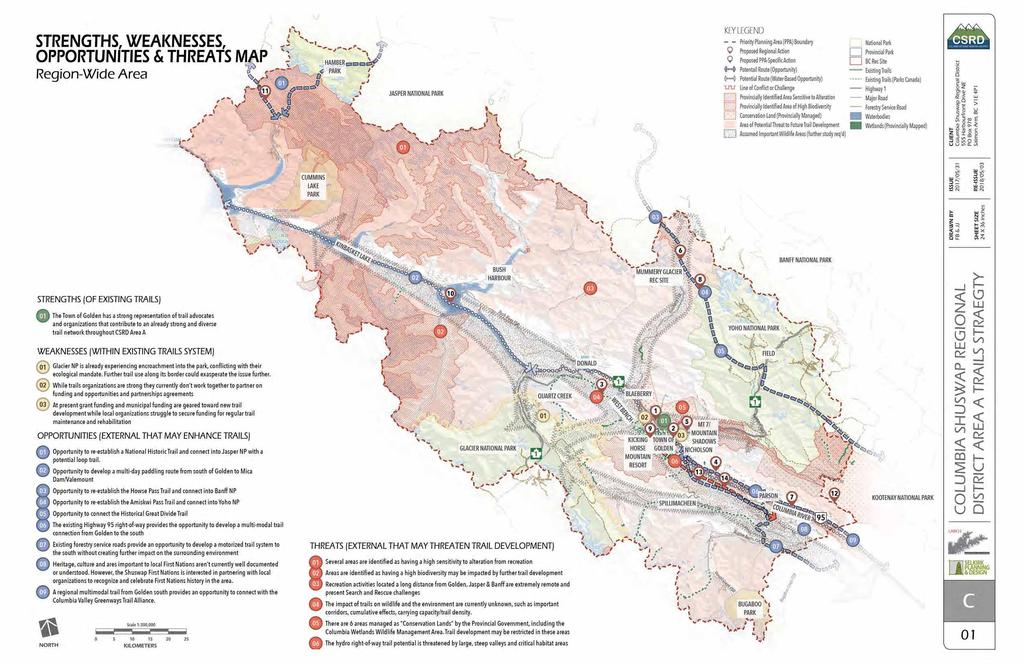
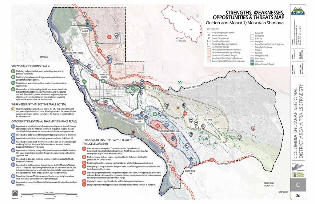
45 SWOT Mapping + Analysis Needs Assessment Extensive List SWOT Mapping Analysis Decision Making Matrix Working Group Review Short List of Priorities 7 STRENGTH, WEAKNESS, OPPORTUNITY + THREAT [SWOT] MAPPING Building upon the inventory and needs assessment data developed throughout the stakeholder and public engagement phase, the project team undertook a hybrid PEST/SWOT Analysis approach. The needs assessment generated an unfiltered collection of over ideas, opportunities, deficiencies, and potential projects for consideration. The PEST approach analyzes big picture opportunities and threats (Political, Economic, Socio-cultural, and Technology). For example this method would identify a political factor such as an applicable Rural Dividend grant and the opportunity to apply for funding. By looking at these external trends, it informs the development of strengths, weaknesses, opportunities, and threats (SWOT). The project team has undertaken a series of mapping exercises to identify the strengths, weaknesses, opportunities, and threats represented throughout the Electoral Area A boundary. The SWOT analysis approach allows the project team and working group to analyze the spatial relationships of underutilized spaces, barriers, land ownership, wildlife, vegetation, potential development areas, and critical linkages through the lens of the vision and guiding principles. These SWOT analysis maps have been developed in tandem with the decision making matrix to filter the extensive needs assessment list while taking into consideration the community desires, demographics, environmental, political and financial complexities. The SWOT mapping exercise incorporates community feedback about existing issues and opportunities. Feedback was gathered through the public open house, the community survey, input and information from the working group, and through direct contact with trails organizations / user groups / First Nations / governmental officials. Where possible this knowledge has been mapped. The criteria for identifying Strengths, Weaknesses, Opportunities, and Threats is all considered in the context of establishing trails. Strengths and Weaknesses are internal or specifically related to a trail, piece of infrastructure, organization, or trail area. Opportunities and Threats are external and relate specifically to non-existent or non-trail-related factors that need to be considered before deciding to support (or not) trail development. Ex: An area of high ecological value is an overall strength of Area A, but it would threaten any trail development. For the mapping purposes, it s been identified as a threat to trail development. REGIONAL TRAIL STRATEGY - ELECTORAL AREA A - DRAFT TECHNICAL MEMO #4 Columbia shuswap regional district - MAY 3,, 8 37

46 Photo: Gorman Lake Trail LARCH Landscape Architecture
47

48

49

50

51
52

53

54

55
 to be applied to the evaluation and ranking of each list item.")
56 Decision Making Matrix 8 DECISION MAKING MATRIX Building upon the SWOT Mapping Analysis, the needs assessment list is further scrutinized through a decision-making matrix, that allows for multiple factors (cost, location, constructibility, public support, environmental impact, cultural factors, funding opportunities, etc.) to be applied to the evaluation and ranking of each list item. This allows the project team to prioritize and rank initiatives in an objective manner that is transparent and defensible. The result of the SWOT Mapping Analysis and Decision Making Matrix is a short list of initiatives to be formulated into phasing opportunities summarized in Section - Implementation. This short list was presented to the Client and Working Group within Technical Memoranda #3 and publicly available after incorporating comments and revisions. The Evaluation Criteria for the Decision Making Matrix is as follows: Photo: Mount 7 LARCH Landscape Architecture Table 4: DECISION MAKING MATRIX EVALUATION CRITERIA GBRAP COMPATIBILITY (SOCIAL/ENVIRONMENTAL/ECONOMIC/CULTURAL) A. Consistent with GBRAP (Golden Backcountry Recreation Access Plan, ) B. Requires consultation with GBRAC (Golden Backcountry Recreation Access Committee) C. Conflicts with GBRAP = GBRAP Compatible, no issues 5 = May require review from GBRAC Committee = Not compatible with GBRAP, contradicts 48 REGIONAL TRAIL STRATEGY - ELECTORAL AREA A - DRAFT TECHNICAL MEMO #4 Columbia shuswap regional district - MAY 3, 8
57 Decision Making Matrix ENVIRONMENTAL A. Environmental concerns or mitigation required B. Red/Blue/Rare Species C. High Biodiversity Emphasis Option GBRAP Landscape Units D. Sensitivity to alteration E. Opportunity for environmental improvements F. Incompatible use creating environmental damage G. Provincial or Federal Restrictions, Notations, etc. = Minimal environmental concerns or project would improve environmental conditions = Severe environmental concerns ECONOMIC A. Capital Cost B. Operating cost C. External funding available to offset costs D. Catalyst for other actions, partnerships, and/or funding = No concerns over attaining funding capitol or operating costs = Major concerns over obtaining funding or funding sustainability SOCIAL A. Availability and willingness of an organization to be project champion or leader B. Actionable clearly defined C. Efficient the strategy addresses many goals at once E. Effective the strategy has a high impact on the goals it is crucial for the future F. Public Safety i.e. Search and Rescue Access = Organization or champion available and capable, clearly defined goals and objectives = Lacking an available champion, not clearly defined goals and objectives CULTURAL A. Indigenous support or conflict B. Existing community and stakeholder support C. Potential to garner commitment from many people/user groups D. Land ownership or tenure holder coordination required = Indigenous and Community support, no opposition, strong commitment 5 = Cultural Heritage Assessment required Archaeological, Heritage, Medicinal = Opposition from multiple groups and lack of overall support REGIONAL TRAIL STRATEGY - ELECTORAL AREA A - DRAFT TECHNICAL MEMO #4 Columbia shuswap regional district - MAY 3,, 8 49
58 Decision Making Matrix Table 5: CSRD AREA A: REGIONAL TRAILS STRATEGY DECISION-MAKING MATRIX Action Number Description PPA PPA Name PPA - : REGIONAL LINKAGES Combined Score GBRAP (Env, Social, Economic, Cultural) Environmental Economic Social Cultural Term Notes - GBRAP Compatible - greatest - greatest - greatest - greatest STRATEGIC INITIATIVE: Form Trails Alliance for Golden and Area A Regional Short Complete a phased feasibility study for a multi-modal trail within the Highway 95 ROW from Golden to Nicholson (Phase ). Regional Med If feasible undertake fundraising, detailed design, and construction for Phase. Coordinate with Columbia Valley Greenways Trail Alliance. Golden to Habart/Nicholson Multi-Modal Legacy Trail 3 STRATEGIC INITIATIVE: West Bench Environmental Impact/Cultural Heritage Study Regional Short Cultural Heritage Study in coordination with the Shuswap Territorial Land Stewardship Team 4 Complete a phased feasibility study for a multi-modal trail within the Highway 95 ROW from Nicholson to Parson (Phase ). Regional Long If feasible undertake fundraising, detailed design, and construction for Phase. Coordinate with Columbia Valley Greenways Trail Alliance. Nicholson to Parson Multi- Modal Legacy Trail 5 Funding for Asset Management, Trail Maintenance and Rehabilitation Regional Current Weakness - At present grant funding and municipal funding are focused toward new trail development while local organizations struggle to secure funding for regular trail maintenance and rehabilitation. There is an opportunity to revise funding policies to enable capitol for the trail alliance or individual organizations to undertake asset management analysis and the establishment a paid trail crew to focus on maintaining and improving established trails while closing and rehabilitating trails no longer being used. 6 Work with Multiple Stakeholders to Re-Establish the David Thompson Heritage Trail and Access to Mummery Glacier Regional Immediate Low use levels, wildlife corridor, Indigenous values, Non-motorized only. Partially funded through multiple grant streams for th Great Divide Trail Association. Multiple project phases including: Construct new bridge at Lambe Creek, Mummery Glacier trail improvements and signage, Ensign Creek FSR, Howe s Pass trail improvements, cable car over Cairns Creek, Cairns Creek Rec Site improvements. Long term access improvements to access road requires partnership agreements. 7 Complete a phased feasibility study for a multi-modal trail within the Highway 95 ROW from Parson/South (Phase 3). Regional Long If feasible undertake fundraising, detailed design, and construction for Phase 3. Coordinate with Columbia Valley Greenways Trail Alliance. Parson South Multi-Modal Legacy Trail 8 Work with Parks Canada to Re-Establish the Amiskwi Pass Trail Regional Med Coordination with Tenure Holder required, motorized concerns summer and winter 9 STRATEGIC INITIATIVES: Establish priorities/policies through the Trails Alliance to refine the long term vision on 3rd party races, incorporating the results of cumulative effects modeling. Regional Short Work with BC Rec Sites and Trails to Identify Potential Camping Spots for Multi-Day Paddling Trips Regional Short A system of camping areas and rest stops that can by used by multi-day paddlers. Contingent on the Columbia Wetlands Wildlife Management Area (WMA) Management Plan currently in progress Work with Parks Canada to Re-Establish Athabasca Pass Heritage Trail Regional Long Restore the Athabasca Pass Heritage Trail and connect as part of a hiking/paddling route through CSRD Area A and Jasper NP. Re-Establish the Harrogate Pass Historical Trail to Dainard Lake Regional Long 3 Explore Possible Motorized Trail Network Using Existing FSRs from Nicholson - South Regional Short 4 Conduct a Motorized Hydro Line Feasibility Study: Mile - South Regional Long Wayfinding improvements through signage, electronic application, updates to Backcountry Maps. Feasibility study for motorized access in powerline ROW. Require buy-in from BC Hydro. Note: Not recommended for implementation - Stakeholder concerns 5 REGIONAL TRAIL STRATEGY - ELECTORAL AREA A - DRAFT TECHNICAL MEMO #4 Columbia shuswap regional district - may 3, 8
59 Decision Making Matrix Table 5: CSRD AREA A: REGIONAL TRAILS STRATEGY DECISION-MAKING MATRIX Action Number Description PPA PPA Name PPA - : KINBASKET Combined Score GBRAP (Env, Social, Economic, Cultural) Environmental Economic Social Cultural Term Notes - GBRAP Compatible - greatest - greatest - greatest - greatest 5 Work with BC Rec Sites and Trails to formalize the Help Lake/Blackwater Climbing Area, Trails, and Staging Area Kinbasket Immed Help Lake Climbing Area. Columbia Valley Climbing Society has received partial funding through 8 Grant funding 6 STRATEGIC INITIATIVES: Complete a Kinbasket Heritage Inventory Assessment Study Kinbasket Short Lead: Shuswap Territorial Stewardship Team 7 Work with BC Rec Sites and Trails to Establish and Sign River Access for Small Boats at Wisted Creek or Beaver Mouth Rec Site Kinbasket Med Canoe Access at either Wisted Creek or Beaver Mouth Rec Areas 8 STRATEGIC INITIATIVES: Identify and Map Wilderness Preservation Zones in the Kinbasket area. Kinbasket Medium PPA - 3: DONALD/BLUEWATER 9 STRATEGIC INITIATIVES: Explore the Long Term feasibility of developing a Multi-Modal Trail connection from Golden to Donald. 3 Donald/Bluewater Long If feasible undertake fundraising, detailed design, and construction. Coordinate with Columbia Valley Greenways Trail Alliance. STRATEGIC INITIATIVES: Explore Potential Boat Launch Blueway Connection Locations 3 Donald Bluewater Med PPA - 4: QUARTZ/GORMAN Complete/On-going Road Access Improvements to Gorman Lake and Complete Trailhead Improvements 4 Quartz/Gorman Short Opportunities for access improvements and funding through Tourism Infrastructure, Grants, and collaboration with Shuswap Band. Collaboration with Tenure holders required. Incorporate Signage for Allowed Uses (Climbing, biking, motorized, etc.) at new Trailhead Signage. Access improvements. Formalize Gorman Climbing Access Trails 4 Quartz/Gorman Short Cliff/Crag area of Gorman used by Climbers 3 Install Regulatory Signage at Wiseman Lakes indicating Sensitive Environment and Motorized Restrictions if West Bench trail 4 season use is approved. 4 Quartz/Gorman Short 4 Ensure Regulatory Signage at Lang Lake Trail has current information 4 Quartz/Gorman Short 5 Complete Hiking Trail and Signage Improvements from KHMR to Wisdom Tooth Lookout including information on restrictions and closures in Holt and Gorman 4 Quartz/Gorman/ KHMR Med Improve the trail condition to Holt Lake and Gorman Lake from KHMR. Install signage to improve wayfinding and provide information on restrictions and closures in Holt and Gorman 6 Work with multiple stakeholders (BC Rec Sites & Trails, Parks Canada, Golden Trails Alliance) to complete a Quartz Creek Summer Alpine Trail Feasibility Study 4 Quartz/Gorman/ KHMR Med Opportunity for non-motorized alpine trail pilot project based on environmental analysis and discussion with FLNRO. Conduct feasibility study and apply for Section 57 7 Quartz Creek Trail Improvements for Early Season Use - Winter 4 Quartz/Gorman Immed Golden Snowmobile Club has received funding through 8 Grant funding for stump and boulder removal for early season grooming 8 Establish Hand Boat Launch and Blueway Sign for River Paddlers at Marl Creek Provincial Park 4 Quartz/Gorman Med Coordination and exact placement required with BC Rec Sites and Trails 9 Complete Gorman Motorized Staging Areas Improvements to Parking Areas and Snow Removal 4 Quartz/Gorman Med Maintenance agreements required 3 Enhance and Improve the % Heritage Trail from Gorman Creek to Quartz Creek Rec Trail for 4-Season Use 4 Quartz/Gorman Long % Heritage Trail from Nicholson to Cedar Lake and from KHMR to Gorman/Quartz 3 Work with BC Rec Sites and Trails to formalize GORMA West Bench Motorized Trail Network 4 Quartz/Gorman Short Recommendation based on discussions with Ministry of Forests, Lands, Natural Resource Operations, and Rural Development (FLNRORD) representatives 3 Work with BC Rec Sites and Trails to Revise Management Plan to Address Environmental Damage and Explore Potential Improvements to Quartz Creek Cabin Infrastructure: Wood Heat, Wood Shed, Internet Service 4 Quartz/Gorman Med Management Plan to Address Environmental Damage and Explore Potential Improvements to Quartz Creek Cabin Infrastructure: Wood Heat, Wood Shed, Internet Service REGIONAL TRAIL STRATEGY - ELECTORAL AREA A - DRAFT TECHNICAL MEMO #4 Columbia shuswap regional district - may 3, 8 5
60 Decision Making Matrix Table 5: CSRD AREA A: REGIONAL TRAILS STRATEGY DECISION-MAKING MATRIX Action Number PPA - 5 BLAEBERRY Description PPA PPA Name Combined Score GBRAP (Env, Social, Economic, Cultural) Environmental Economic Social Cultural Term Notes - GBRAP Compatible - greatest - greatest - greatest - greatest 33 Improve Rec Site Facilities at Redburn Creek (OB) Campground 5 Blaeberry Med Opportunity to improve signage at Redburn Creek (OB) Campground/Rec Site. Potential for future pit toilets. 34 Improve Trailhead Facilities at Thompson Falls (Syd s Trail) 5 Blaeberry Short Opportunity to improve wayfinding signage at trail to Thompson Falls (Syd s Trail). 35 Explore Blueway Site Designation at Burges and James Cadsden Provincial Park 5 Blaeberry Med -3 primitive camping sites in Burges & James Gadsden Provincial Park accessible from the River to provide camping with primitive facilities for people doing a multiday canoe on the Columbia, or a rest spot for those paddling the Blaeberry for the day. 36 Complete Signage Improvements to Willowbank Trail to Reduce Access Issues on Private Land 5 Blaeberry Med Signage improvements in Willowbank Area to reduce access issues on private land PPA - 6: GLENOGLE 37 Explore Opportunities to Improve Access Trail to Moberly Peak 6 Glenogle N/A Mining in area has impacted trail access. Coordination required to explore access while maintaining public safety. Note: Not recommended for implementation - Stakeholder concerns PPA - 7: KICKING HORSE MOUNTAIN RESORT 38 Explore Opportunities to Construct an Adaptive Trail within Kicking Horse Mountain Resort Bike Park 7 Kicking Horse Mountain Resort & Backcountry Med KHMR tenure to develop if desired. Opportunity to expand recreation service types and create a known adaptive destination trail within the BC Adaptive Trail Network (Nakusp, Revelstoke, Whistler) 39 Improve Scalli Mag Single Track Trail to Address Environmental Issues and Provide Important Connection within the Trail Network. 7 Kicking Horse Mountain Resort & Backcountry Immed Improve Scalli Mag trail to address drainage issues. Important connection from KHMR to Moonraker trail network. Not intended to serve as mainline for adjacent trail development. Maintain as a single trail connection to minimize impact to wildlife. Improvements to this trail have been brought up through engagement events and with stakeholders. Designated RM. Non-motorized, mild development use. Cumulative effects info/study would inform impacts on Wildlife corridor. Opportunity for winter grooming as a fat bike connection from KHMR. 4 Improve Trail Connectivity and wayfinding signage through the KHMR Neighbourhoods 7 Kicking Horse Mountain Resort & Backcountry Med Further develop the trail network connecting the different streets and subdivisions around the resort to provide both better ski access, as well as snowshoeing opportunities and walking/biking in the summer. 4 Explore Options to Expand Summer Hiking Trail from Upper Kranky Pants to Peak 7 Kicking Horse Mountain Resort & Backcountry Med KHMR tenure to develop if desired to expand hiking infrastructure 4 Develop a Hiking Trail from the Base of KHMR to the Peak 7 Kicking Horse Mountain Resort & Backcountry Med Develop a hiking trail from the gondola base to the top of the mountain. KHMR tenure to develop if desired to expand hiking infrastructure. 43 Implement Use Restrictions to T4 Trail to permit Hiking/Trail Running only and Trail and Landscape Rehabilitation 7 Kicking Horse Mountain Resort & Backcountry Med Use level issues for wildlife, environmental concerns, intense pressure from community and races. Coordination with Rod and Gun club required. RM summer and winter. Goat Habitat and High Biodiversity. 44 Complete improvements to % (Historic Columbia River Lumber) Heritage Trail from Cedar Lake to Gorman Creek 7 Kicking Horse Mountain Resort & Backcountry Long % Heritage Trail from Nicholson to Cedar Lake and from KHMR to Gorman/Quartz 5 REGIONAL TRAIL STRATEGY - ELECTORAL AREA A - DRAFT TECHNICAL MEMO #4 Columbia shuswap regional district - may 3, 8
61 Decision Making Matrix Table 5: CSRD AREA A: REGIONAL TRAILS STRATEGY DECISION-MAKING MATRIX Action Number 45 Description PPA PPA Name Complete trail improvements to T4 Trail to Provincial Trail Standards and Seek Approvals for Long-Term Trail Sustainability 7 Kicking Horse Mountain Resort & Backcountry Combined Score GBRAP (Env, Social, Economic, Cultural) Environmental Economic Social Cultural Term Notes - GBRAP Compatible - greatest - greatest - greatest - greatest Med Potential to develop a joint project with KHMR to build an in- and out-of-bounds trail connection (ex. purpose built T4 trail). Use level issues for wildlife, environmental concerns, intense pressure from community and races. Coordination with Rod and Gun club required. RM summer and winter. Goat Habitat and High Biodiversity. Issue with funneling additional traffic to Canyon Creek Trail. 46 Explore Feasibility to Formalize and Improve the Former Horse Pack Trail to Goodsir Mine 7 Kicking Horse Mountain Resort & Backcountry Long AKA Porphyry and Iron Hill Mine Note: Not recommended for implementation - Stakeholder concerns PPA - 8: MOONRAKER/CEDAR LAKE 47 Construct Cedar Lake Interpretive Boardwalk in sensitive Riparian Areas 8 Moonraker/Cedar Lake Short Construct interpretive boardwalk trail at Cedar Lake. Opportunity for interpretive signage and environmental programs. Assumes boardwalk construction in impacted and sensitive areas, not a trail around entire Cedar Lake. 48 Explore the potential for establishing Hiking Uptrack/Detours to the Lower Canyon Creek Lookout and Improve Signage to Reduce Conflict 8 Moonraker/Cedar Lake Short Use level issues for wildlife, environmental concerns, coordination with Rod and gun club required. RM summer and winter. Signage and messaging improvements to inform uptrack users to expect downhill bike traffic and danger to exposed cliffs - community/visitor education. 49 Investigate Fat Bike Winter Trail Network and Maintenance/Grooming Opportunities at Moonraker/CBT Trail Networks 8 Moonraker/Cedar Lake Immed Investigate opportunities to create a fat bike inter trail system and maintenance program (packing trails Cedar Camp, Odenata, North Star, Barking Dog, Arrowhead, etc.). Golden Outdoor Recreation Association has received funding through 8 Grant funding and will pilot winter grooming in 9. 5 Complete Twisted Sister Trail 8 Moonraker/Cedar Lake Immed Complete construction of the Twisted Sister, volunteer, hand-built trail. Use levels should be monitored long term for wildlife conflicts. Wildlife corridor quality impact may be a concern. Cumulative effects study would be valuable for this area and trail density. planning. 5 Expand Moonraker polygon to include Black/Double-Black Trails to provide diversity in trail Trails. Area Adjacent to LSD trail with new trails connect to FSR and not to Canyon Creek to reduce environmental impact. 8 Moonraker/Cedar Lake Med Plan/Design a Black and/or Double-Black technical XC Trail(s) adjacent to LSD trail. Apply for polygon for development. Concern over increased use in RM area of Canyon Creek i.e. sensitive goat habitat. Less concern if advanced trails don t all funnel to canyon creek and loop back to the FSR. 5 Enhance and Improve the % Heritage Trail from McBeath Rd to Cedar Lake 8 Moonraker/Cedar Lake Long % Heritage Trail from Nicholson to Cedar Lake and from KHMR to Gorman/Quartz 53 Investigate Maintenance Agreement for Winter Clearing on Dogtooth Forest Service Road to Cedar Lakes Staging Area 8 Moonraker/Cedar Lake Short With mechanized winter grooming funding may not require road to be cleared during winter but winter parking will need to be accounted for with increased use. 54 Plan and Develop New Trails Off Twisted Sister to Create Trail Loop Options in this Area 8 Moonraker/Cedar Lake Long GBRAP RM Designation- Wildlife Corridor further study on maximum trail density and use levels required. 55 Create Jumpline Trail on the Existing Treachery Trail with Ride around Options 8 Moonraker/Cedar Lake Long GBRAP RM Designation - low impact, wildlife corridor. Issues with increased use expected to impact wildlife. REGIONAL TRAIL STRATEGY - ELECTORAL AREA A - DRAFT TECHNICAL MEMO #4 Columbia shuswap regional district - may 3, 8 53
62 Decision Making Matrix Table 5: CSRD AREA A: REGIONAL TRAILS STRATEGY DECISION-MAKING MATRIX Action Number PPA - 9: GOLDEN Description PPA PPA Name Combined Score GBRAP (Env, Social, Economic, Cultural) Environmental Economic Social Cultural Term Notes - GBRAP Compatible - greatest - greatest - greatest - greatest 56 Complete Trail Surfacing and Guardrail Improvements for the Rotary Trail to Keith King Memorial Sportsfields 9 Golden Immed Town of Golden initiative planned once windstorm clean-up is complete. Opportunity for reclamation projects to restore damage from windstorm and timber removal. Opportunity to make improvements for accessibility and Age friendly design Opportunity for bench nodes, educational signage, and protection of rare species and sensitive vegetation communities. 57 Construct a new Bike Skills Park utilizing Terrain Based Principles 9 Golden Short 58 Complete Rotary Trail Widening Potential Paving, Lighting in Strategic Locations 9 Golden Med 59 Develop Interpretive Trails/Signage at the Old Mill Heritage Site 9 Golden Med 6 Formalize Trails and Signage Improvements at Confluence Park 9 Golden Med 6 Establish Bush Party Trailhead/Potential Staging Area 9 Golden Med Current bike skills park does not meet current needs of the community. Opportunity to improve, expand, or relocate Note: The Town of Golden received grant funding for $5.87M for the Kicking Horse River Dyke Improvements Project. The extent of pathway and public realm improvements is currently unknown but this initiative will prove to be a markable improvement to the Rotary Trail in high use areas. Interpretive attraction - critical piece of original infrastructure. Public safety concerns i.e. holes to fall in, town liability Plan through Columbia Valley Greenway Alliance - 6 interpretive stations, Threat trail improvements must account for seasonal water levels of the Columbia River Opportunity to establish a small parking/staging area near Bush Party Trailhead for approximately 5 vehicles 6 Ensure Multi-Modal Pedestrian Access Across Columbia River when Bridge Updates Are Planned 9 Golden Coordination with KHMR, CP, Town of Golden Required. Assumes minimal environmental impact as bridge replacement would require environmental mitigation. 63 Provide Trail Improvements to Anderson Road/Edelweiss Slough and Explore Opportunities for Interpretive/Nature Information Signage 9 Golden Med Threat due to environmental damage, Opportunity to improve through small boardwalk and trail improvements. This trail serves as an important Community Connection. Educational/Interpretive opportunities through signage and programming. 64 STRATEGIC INITIATIVE: Proceed with Skatepark Expansion Phase 9 Golden Long Once funding is available or organization applies for and receives funding. Ensure design for Phase II meets the needs of the community and current skatepark design standards. 65 Complete Signage Improvements of Hospital Falls Trail 9 Golden Med Signage improvements at trailhead 66 Create a Multi-Modal Trail Along the Highway Bypass from 6th St. to Reflection Lake 9 Golden Long Create a multi-modal connection along the highway bypass from 6th Ave S/4th St. S (Sikh Temple) along the railway line, under HWY 95 bridge to Reflection Lake. Community Connection. Coordination Required With CP and Town of Golden 67 Create a Pedestrian/Cycling Crossing of the Kicking Horse River at the CP Bridge Near Confluence Park 9 Golden Long Community Connection. Coordination Required With CP and Town of Golden. Currently unlawful to cross though some do. Opportunity to create a Legal Loop. 68 Create a Multi-Modal Pathway Along Fisher Rd 9 Golden Long Community Connection and Age Friendly/Mobility Improvements 69 Create a Community Trail Connection from the Golden Visitor Centre to Canyon Ridge 9 Golden Long Currently no community connection. Concern over erodibility and steepness of slope. 7 Create a Multi-Modal Pathway Along Kicking Horse Dr 9 Golden Long Community Connection and Age Friendly/Mobility Improvements 54 REGIONAL TRAIL STRATEGY - ELECTORAL AREA A - DRAFT TECHNICAL MEMO #4 Columbia shuswap regional district - may 3, 8
63 Decision Making Matrix Table 5: CSRD AREA A: REGIONAL TRAILS STRATEGY DECISION-MAKING MATRIX Action Number Description PPA PPA Name PPA - : MT 7/MOUNTAIN SHADOWS Combined Score GBRAP (Env, Social, Economic, Cultural) Environmental Economic Social Cultural Term Notes - GBRAP Compatible - greatest - greatest - greatest - greatest 7 Establish Trailhead at the Mount 7 Staging Area with Wayfinding Signage at Strategic Locations along trail to Mount 7 Summit Mt 7/Mountain Shadows Short Signage improvements for public safety and wayfinding. GBRAP only sanctioned area for heli biking and scree riding. Mount 7 was intended to be the mountain biking hot spot. Historic significance - Psychosis Race 7 Complete Schacher Trail to Mt. 7 Summit: Maintenance and Sustainability Improvements Mt 7/Mountain Shadows Immed Trail construction is near complete. Regular maintenance and sustainability improvements once operational. Trail will serve as a mainline trail for looped trail development long term. 73 Plan and Develop New Trails off the Schacher Trail to Create a Looped Trail Network Mt 7/Mountain Shadows Med Establish Schacher Trail as the preferred uptrack trail and create new trail development as a looped trail system off Schacher Mainline Trail. 74 Analyze and improve existing sanctioned/unsanctioned Mount 7 trails Mt 7/Mountain Shadows Med Inventory and analyze existing sanctioned/unsanctioned trails within Mt. 7 network, sustainability improvements, trails no longer being used to be decommissioned. Lead: GCC 75 Establish a Staging Area at base of Snake Hill/Tailgate (Shared with MTB, GORMA, Equestrian, etc.) Mt 7/Mountain Shadows Med Multiple groups express interest in improving and managing this staging area as a shared amenity 76 Design a Family-Friendly and Accessible Trail in the Mountain Shadows Area. Potential for Adaptive Trail as within the Family Friendly Trail Area Mt 7/Mountain Shadows Med Opportunity to expand recreation services and improve the family friendly/adaptive trail network 77 Formalize Climbing Access Trail off Mountain Shadows Trails to Magma Crag Climbing Area Mt 7/Mountain Shadows Med Existing Climbing Area. Better trail access through Mt. 7/Mountain Shadows Trail Network 78 Design a new modern motocross track in conjunction with GORMA Trail System development. Reclaim and re-purpose existing site to more suitable use. Mt 7/Mountain Shadows Med Motorized use in wetland setting and adjacent to equestrian use is not compatible. Opportunity to relocate and improve infrastructure for all affected user groups. Opportunity to design something that is world class and a model for sustainable motorized recreation design 79 Establish a Schacher Staging Area between 6.5km or km Mt 7/Mountain Shadows Med With Shacher Trail development near complete, constructing a staging area near the mid point will accommodate increased vehicle traffic and parking due to shuttling - Design for 5-7 vehicles 8 Design and Construct a Jump/Flow Trail on Mt 7 Mt 7/Mountain Shadows Short Create a jump/flow trail on Mt 7 as a blue trail, with black options. Weakness there is currently no sanctioned jumpline trail within the Mountain Shadow or Mount 7 Network.. 8 Develop Shared Use Trails for MTB and Motorized Use - Advanced Trials and Mountain Bike Use Mt 7/Mountain Shadows Med Opportunity for collaboration between Golden Cycling Club and GORMA to create black trails for mountain bikes and trials motorbikes. Opportunity for signage improvements and messaging. Potential for E-bike trail development for Shared Use (Motorized + Non-Motorized Traffic) 8 Improve Overall Signage On Mount 7 to Indicate Shared Use Trails Mt 7/Mountain Shadows Short Create signage to indicate that motorized use is permitted on trails (Cliffside, Rockabout, Trial and Error, Chute the Duck) 83 Work with BC Rec Sites and Trails to establish a Recreation Area for the Mount 7 and Mountain Shadows Trails. Mt 7/Mountain Shadows Short Apply for a Section 56 for the Mountain Shadow Trail Network. Update current Memorandum of Understanding with Tenure holder if required. REGIONAL TRAIL STRATEGY - ELECTORAL AREA A - DRAFT TECHNICAL MEMO #4 Columbia shuswap regional district - may 3, 8 55
64 Decision Making Matrix Table 5: CSRD AREA A: REGIONAL TRAILS STRATEGY DECISION-MAKING MATRIX Action Number Description PPA PPA Name PPA - : KICKING HORSE RIVER Combined Score GBRAP (Env, Social, Economic, Cultural) Environmental Economic Social Cultural Term Notes - GBRAP Compatible - greatest - greatest - greatest - greatest 84 Explore opportunities for Trailhead and Parking Improvements for Kicking Horse Climbing Area Kicking Horse River Med Known climbing area that lacks adequate parking facilities. May require coordination with Highway Zoning. 85 Explore an Overflow/Alternative Parking Location for Kicking Horse Climbing Area Kicking Horse River Med Known climbing area that lacks adequate parking facilities. May require coordination with Highway Zoning. 86 Install signage and wayfinding improvements to Table Mountain and Frenchman s Ridge Trails Kicking Horse River Med Opportunity to improve the Table Mountain and Frenchman s Ridge trailhead and wayfinding at 3 decision making nodes PPA - : NICHOLSON/CERTAINTY MINE/HOBO REPEATER 87 Complete a Feasibility/Impact Study for trail development in the Certainty Mine, Mile, 4 Mile, Hobo Repeater Complex Nicholson/Certainty Mine/Hobo Repeater Short Weakness - Recreation pressure in area. Wildlife concerns, concern over damage. RM Designation. Bear habitat. Potential for Mile, 4 Mile, Hobo Repeater Complex. Opportunity to explore environmental protection areas, access improvements, parking and trailhead facilities. Opportunity to be encompassed in West Bench studies. 88 Explore opportunities to establish and sign a trail from Cedar House to the Mt. 7 Summit in conjunction with a trail connection from Cedar House to Rock About. Nicholson/Certainty Mine/Hobo Repeater Med Currently low use levels. Opportunity to explore connectivity improvements. 89 Complete Trailhead and Signage Improvements at Canyon Creek Road in Nicholson Nicholson/Certainty Mine/Hobo Repeater Med Informal Parking occurring that may cause conflict with adjacent land owners - explore opportunities to establish trailhead and signage 9 Explore the feasibility of establishing a Motorized Network for Canyon Lake Area Nicholson/Certainty Mine/Hobo Repeater Long Area is close to wetlands that access is prohibited seasonally. Motorized use permitted with partial restrictions in adjacent areas per GBRAP. Tenure holder on adjacent lands requires consultation prior to applications for any proposed development. Note: Not recommended for implementation - Stakeholder concerns PPA - 3: KAPRISTO 9 Complete Trailhead and Signage Improvements at Kapristo Crag with trail application approval 3 Kapristo Med Lack of signage with potential for public safety implications. Proper water crossings required, potential to apply for protection for old growth forest. Low use levels and experienced climbing ability required. PPA - 4: MOOSE 9 Explore ongoing maintenance agreement for Wolverine Pass Trail to Kootenay NP. New Signage to be installed Summer 8 by BC Rec Sites and Trails 4 Moose Immed Not for formalization of camping on the boundary. Signage approved and provided by BCRST. High wildlife and biodiversity area, also within conservation lands area. PPA - 5: PARSON/HARROGATE/SPILLIMACHEEN 93 Complete access improvements to established Silent Pass and McMurdo Trails including regulatory improvements to illustrate closure boundaries and enforcement. 5 Parson/Harrogate/ Spillimacheen Med Opportunity for improvements and illustrating closures 94 Explore feasibility of maintaining the Goodluck Trail 5 Parson/Harrogate/ Spillimacheen Long Remote and difficult travel, wilderness route. Historic significance. 95 Create a Permanent Staging Area for Silent Pass Trail - Install Trailhead Signage and Safety Messaging and Infrastructure: Beacon Check 5 Parson/Harrogate/ Spillimacheen Short Deficient parking, no proper staging area, no beacon check currently. Agreement required with Forestry and private land owners 56 REGIONAL TRAIL STRATEGY - ELECTORAL AREA A - DRAFT TECHNICAL MEMO #4 Columbia shuswap regional district - may 3, 8
65 Decision Making Matrix Table 5: CSRD AREA A: REGIONAL TRAILS STRATEGY DECISION-MAKING MATRIX Action Number Description PPA PPA Name PPA - 3: KAPRISTO Combined Score GBRAP (Env, Social, Economic, Cultural) Environmental Economic Social Cultural Term Notes - GBRAP Compatible - greatest - greatest - greatest - greatest 9 Complete Trailhead and Signage Improvements at Kapristo Crag with trail application approval 3 Kapristo Med Lack of signage with potential for public safety implications. Proper water crossings required, potential to apply for protection for old growth forest. Low use levels and experienced climbing ability required. PPA - 4: MOOSE 9 Explore ongoing maintenance agreement for Wolverine Pass Trail to Kootenay NP. New Signage to be installed Summer 8 by BC Rec Sites and Trails 4 Moose Immed Not for formalization of camping on the boundary. Signage approved and provided by BCRST. High wildlife and biodiversity area, also within conservation lands area. PPA - 5: PARSON/HARROGATE/SPILLIMACHEEN 93 Complete access improvements to established Silent Pass and McMurdo Trails including regulatory improvements to illustrate closure boundaries and enforcement. 5 Parson/Harrogate/ Spillimacheen Med Opportunity for improvements and illustrating closures 94 Explore feasibility of maintaining the Goodluck Trail 5 Parson/Harrogate/ Spillimacheen Long Remote and difficult travel, wilderness route. Historic significance. 95 Create a Permanent Staging Area for Silent Pass Trail - Install Trailhead Signage and Safety Messaging and Infrastructure: Beacon Check 5 Parson/Harrogate/ Spillimacheen Short Deficient parking, no proper staging area, no beacon check currently. Agreement required with Forestry and private land owners REGIONAL TRAIL STRATEGY - ELECTORAL AREA A - DRAFT TECHNICAL MEMO #4 Columbia shuswap regional district - may 3, 8 57
66 Trail Planning + Design 9 TRAIL PLANNING + DESIGN Golden and Electoral Area A is fortunate to have such a knowledgeable, hard working, and dedicated collective of trail builders and maintainers. The recreation trails throughout the area are well designed, constructed, and maintained. A lot of this work is accomplished through organized volunteer events that are well attended by a diversity of community members who are dedicated to giving back and improving the recreation trails throughout Golden and Electoral Area A. Machine built trails, constructed by professional builders may be required to construct trails with higher anticipated use levels, in remote areas, or where earthwork could not be accomplished through manual labour. There are environmental, economic, and social aspects to consider when pursuing trail development opportunities. All trail development should follow the established pre-authorization process through First Nations, Front Counter BC, Recreation Sites and Trails BC, Municipal Government, and local stakeholders. For further information please refer to the Environmental Screening Tool in Appendix B. 9. ENVIRONMENTAL CONSIDERATIONS FOR TRAIL PLANNING RIPARIAN AREAS Riparian areas surround water bodies including a watercourse (seasonally inundated or not); a pond, lake, river, creek, or brook; a ditch, spring, or wetland. They are composed of moist to saturated soils, water-loving plant species and their associated ecosystems directly influences and provides important fish habitat. As the ground in riparian areas may be seasonally or permanently saturated, they are susceptible to damage and erosion. Preventing damage to riparian areas is much easier than restoring it once damage has occurred. Under the Provincial Riparian Areas Regulation (RAR), local governments are obligated to protect these sensitive areas. A minimum buffer of 3 meters is required around all riparian areas. DOMESTIC WATER LICENSES A community watershed is defined under the Forest Range and Practices Act (FRPA) as all or part of the drainage area that is upslope of the lowest point from which water is diverted for human consumption by a domestic water license. Trail development within the watersheds of domestic water licenses is put higher levels of scrutiny as soil disturbance and erosion can lead to negative impacts on the quality of drinking water. UNGULATE WINTER RANGE The Forest Range and Practices Act (FRPA), defines Ungulate Winter Range (UWR) as an area that contains habitat necessary to meet the winter habitat requirements of an ungulate species. Trail development should not occur in recognized UWR areas. ALPINE TERRAIN Alpine terrain lies approximately at elevations 8m and above in Area A. The Interior Mountain-heather Alpine (IMA) Zone occupies the Columbia Mountains and the south eastern Rocky Mountains. In alpine regions, the physical environment dictates the vegetation. Whether the terrain is gentle or extremely rough, the smallest differences in the micro-environment are important. Soils are typically shallow and derived from weathered bedrock. Since cold retards the process of weathering, soils and plants develop slowly in this zone. The drier parts of the Interior Mountain-Heather Alpine in the east Kootenays and the lee of the Coast Mountains are home to some of the densest populations of mountain goat and other ungulates in the world. These areas represent important habitat for the species who inhabit the alpine territory. Vegetative cover includes stunted trees including the Whitebark Pine, Mountain Heather, and wildflowers. Alpine vegetation is very sensitive to compaction and disturbance and restoration is much more lengthy and challenging than at lower elevations. Wildlife are easily displaced in alpine habitats and are known to abandon favourable habitat due to disturbance. Public pressure for recreation opportunities within the alpine is very high and increasing with the use of social media and helicopter access. Trail use or development in alpine areas should be carefully considered to avoid sensitive vegetation and seek to minimize impacts to terrain and wildlife populations. Environmental planning and assessments are now required to be undertaken prior to application for trail development and must demonstrate an ability to mitigate and minimize damage, measure cumulative effects, estimate use levels, and provide a monitoring and management plan. In some cases where mitigation is not possible, trails may not be approved if the area is highly sensitive, or that if monitoring shows negative environmental impacts, the trail may have to be deactivated. 58 REGIONAL TRAIL STRATEGY - ELECTORAL AREA A - DRAFT TECHNICAL MEMO #4 Columbia shuswap regional district - MAY 3, 8
67 Trail Planning + Design Helicopter access and landing points within the backcountry have been explored extensively through the Golden Backcountry Recreation Access Plan (GBRAP). Local helicopter companies should adhere to regulations and restrictions except for emergency situations. 9. ENVIRONMENTAL SCREENING TOOL Environmental Stewardship is essential to ensuring that trails have minimal impact to the natural environment. The following Environmental Screening Tool can be integrated from trail planning and development through trail use and long term management. The Environmental screening tool covers four categories: Water, Plants, Wildlife, and Interfaces. Please refer to Appendix C, for the full Environmental Screening Tool Table. Table 6: ENVIRONMENTAL SCREENING TOOL DESCRIPTION Environmental Categories Environmental Feature Potential Environmental Effects of Project Mitigation Measures Links to Legislation and Guidelines Monitoring Indicators of Negative Effects Limits of Indicators Corrective Actions Water Plants Wildlife Interfaces Subcategories of each Environmental Category (i.e. Water > Streams) Description of potential impacts and rationale for mitigation measures Description of mitigation best practices Internet links to more information Description of monitoring methods/tools Indicators suggesting required corrective actions Indicators of success Additional mitigation measures 9.3 SUSTAINABLE TRAIL DESIGN PRINCIPLES Sustainable trail design is a complex combination of site engineering, drainage, knowledge of vegetation, erosion and sediment control, geometry, and creativity. It is not an exact science and should embrace artistic expression to ensure trails are unique, fun, and diverse all while fitting seamlessly into the beautiful surrounding natural environment. Poorly constructed trails can be maintenance intensive and expensive. Trail planning and design is receiving much higher levels of scrutiny from the community and from provincial government. Higher emphasis is being placed on proper planning and environmental consideration, stakeholder and community engagement, and design and construction by qualified professionals. Ongoing education and outreach initiatives to ensure decision makers, trail designers, and trail builders are knowledgeable regarding sustainable trail concepts, techniques, and technology is crucial to ensuring effective implementation. The following represents a few of the sustainable trail principles available. It should be noted that these trail design principles apply to hiking, biking, equestrian, adaptive, and motorized trail design. For more information please consult IMBA Trail Solutions, District of Squamish Trail Standards, Whistler Trail Standards, and British Columbia Chapter - Recreation Trail Management. AVOID THE FALL LINE Fall-line trails usually follow the shortest route down a hill - the same path that water flows. The problem with fall-line trails is that they focus water down their length. The speeding water strips the trail of soil, exposing roots, creating gullies, and scarring the environment. THE HALF RULE The trail grade should not exceed half the grade of the sidehill it is located on. Grade is the elevation gained divided by the distance of the segment of the track (expressed as a percentage). For example, a trail across a sideslope of % should not exceed %. THE -PERCENT AVERAGE GUIDELINE The average trail grade is the slope of the trail for an entire uphill/ downhill section. Generally, an average grade of % or less is most sustainable. REGIONAL TRAIL STRATEGY - ELECTORAL AREA A - DRAFT TECHNICAL MEMO #4 Columbia shuswap regional district - MAY 3,, 8 59
68 Trail Planning + Design MAXIMUM SUSTAINABLE GRADE Typically, the maximum sustainable track grade is about 5% for a short distance, but it is site-specific and varies with trail alignment, use of the half rule, soil type, annual rainfall, vegetation, use of grade reversals, type of users, number of users, and level of difficulty. GRADE REVERSALS + ROLLING GRADE DIPS Grade reversals are short sections of trail that change from climbing to descending, then return to climbing. The reversal shortens the water flow path and enhances the rider experience. Rolling dips are excavated into the trail to convey water off the trail. A rolling grade dip has two design goals. The first is to get the water off the tread surface and the second is to build it long enough that the rider does not realize it is there. TRAIL REHABILITATION + DEACTIVATION Rehabilitating or deactivating a trail may be required due to lack of use, changes in use levels or user requirements, or changes in management objectives. When a trail is designated to be deactivated, access to the previous trail alignment should be restricted using local materials including large boulders, rocks, logs, fallen trees, etc. The visible desire line should be reduced or removed with emphasis on the first 5 meters or within line of sight from all intersections. Tread surface should be scarified to a minimum 5mm depth and regrade to seamlessly meet existing surrounding grades. Deactivated trails should be monitored to ensure re-vegetation and to minimize the introduction of non-native or invasive species. TRAIL PLACEMENT GUIDELINES Avoid wet areas, unstable slopes, erodible soils, embankments, cliffs, stream banks. Avoid flat areas. The trail tread must always be slightly higher than the ground on at least one side of it so that water can drain properly. Utilize natural low points and spillways to remove water flowing along the tread surface. Avoid hazard trees with high wind throw potential. Ensure trail alignment does not negatively impact wildlife species. Avoid critical habitat of rare or fragile vegetation species or communities. Sensitive vegetation can be protected by constructing guardrails or using rocks and logs to minimize travel in the sensitive area. Archaeological sites are protected by The Heritage Conservation Act (HCA). If archaeological material is found during construction or maintenance, stop construction and contact the Provincial Archeology Branch. Avoid trails in community watersheds and domestic water licenses. Avoid alignments that encourage user shortcutting. Utilize existing landforms or vegetation to block potential shortcut routes. Avoid creating a trail alignment in close proximity to another trail to avoid trail proliferation or shortcuts between. Do not construct trails on organic surface layer. Utilize local rocks and boulders in sensitive areas and steep descents to minimize trail erosion. 6 REGIONAL TRAIL STRATEGY - ELECTORAL AREA A - DRAFT TECHNICAL MEMO #4 Columbia shuswap regional district - MAY 3, 8


69 Trail Planning + Design Figure 7 Designing + Building Sustainable Trails - IMBA Canada REGIONAL TRAIL STRATEGY - ELECTORAL AREA A - DRAFT TECHNICAL MEMO #4 Columbia shuswap regional district - MAY 3,, 8 6
70 Implementation IMPLEMENTATION The following section builds upon the Decision Making Matrix and SWOT mapping analysis in Section 7 and Section 8 to provide a short list of actionable recreation initiatives, phasing, financial projections, and a framework for implementation.. ASSET MANAGEMENT Asset management is a key component for a wide range of businesses and organizations and is applicable to trail organizations, trail management groups, and municipalities. Understanding the extent and value of current assets in the form of trail, type, trail length, signage, and technical trail features are important factors when considering strategic development and investment in local trail networks. It may allow an organization to set guidelines for carrying capacity in sensitive areas. It allows organizations to shift from annual budgets to strategic asset management plans incorporating pro-active life-cycle management rather than re-active maintenance. FUNDING OPPORTUNITIES A range of funding opportunities are available for non-profit organizations to secure funding for capital projects and ongoing maintenance including grants, sponsorship, and partnership opportunities including: GRANT FUNDING Grant funding can be secured for capital expenditures, ongoing maintenance, or reclamation work. The following is a list of potential funding sources: Columbia Basin Trust: Community Initiatives and Affected Areas Program Columbia Basin Trust: Recreation Infrastructure Grants Columbia Basin Trust s mandate is to support the ideas and efforts of communities and people in the Columbia Basin. CBT administers a wide range of grants, many of which can be applied to trail projects. Mountain Equipment Co-op Young Canada Works Focus on Historic and Cultural Site Interpretive Projects. Potential partnership opportunities with the Golden and District Museum and Archives Bike BC after damage has occurred. Asset management can also set an organization practicing asset management apart from others in the eyes of potential funders. It is not within the scope of the Regional Trail Strategy to provide an asset management plan for trails in Golden and Area A, however, the GIS data compiled in the GIS database from this project combined with annual data collected through trail counter devices, STRAVA data, and other data analytics will be a powerful tool for a Trail Alliance and/ or stakeholder groups moving forward in an organized and informed fashion. fundingengagement-permits/funding-grants/cycling-infrastructurefunding BC Equestrian Trails Fund Real Estate Foundation BC Annual intake REFBC Grants TD Friends of the Environment BC Community Gaming Grants gambling/grants/guide-cgg.pdf Work BC Job Creation Partnerships Employer-Partnerships.asp Canadian Off-Highway Vehicle Distributors Council Environment and Sustainable Trail Development PARTNERSHIP OPPORTUNITIES + SPONSORSHIP Columbia Shuswap Regional District Trail Maintenance Funding Shuswap Territorial Land Stewardship Access Planning + Maintenance Columbia Valley Credit Union Town of Golden 6 REGIONAL TRAIL STRATEGY - ELECTORAL AREA A - DRAFT TECHNICAL MEMO #4 Columbia shuswap regional district - MAY 3, 8
71 Implementation.3 IMPLEMENTATION MATRIX This Implementation Matrix builds upon the results of the Decision Making Matrix and SWOT Map analysis. This summary synthesizes the results of the extensive community and stakeholder driven process and consolidates the information into the following Short List of development recommendations and initiatives formulated into phased approach. Priorities have been classified using the following breakdown: FINANCIAL PROJECTIONS Recreation Initiatives that score between 84 - are classified High Priority Less than $, are classified lowest Recreation Initiatives that score between are classified Medium Priority More than $, are classified Low Recreation Initiatives that score between - 64 are classified Low Priority $K - $5K are classified medium $5k - $5K are classified as high Greater than $5, are classified very high Note: Financial projections are approximate This Regional Trail Strategy Report is intended to serve as an actionable document that can be updated as trail initiatives are completed. The GIS database developed within this plan will serve as a valuable resource moving forward. It is recommended that the CSRD and the Trail Alliance/User Groups work collaboratively to maintain and ensure the GIS database remains current as projects are completed and priorities shift. The following Implementation Matrix represents the short list of high priority recreation initiatives and is intended to highlight the top scoring initiatives for the recreation network throughout Golden and Area A and provide guidance on initiatives that require further rigor and collective decision making moving forward: Table 7: REGIONAL TRAILS STRATEGY IMPLEMENTATION MATRIX Action Number Description PPA Combined Score Term Lead Financial Projection HIGH PRIORITY INITIATIVES Form Trails Alliance for Golden and Area A Establish Trail Alliance Create Trail Alliance Website - Information Hub Begin Meetings per Trail Alliance Framework. Regional 94 Immed ( Months) Partnership: CSRD / Town of Golden + All Trail User Groups Med - High Complete a phased feasibility study for a multi-modal non-motorized trail within the Highway 95 ROW from Golden to Nicholson (Phase ) Regional 94 Med (-5 Years) Partnership: Trail Alliance, MOTI + CVGTA Med - High 3 Complete a West Bench Environmental Impact/Cultural Heritage Study Regional 9 Med (-5 Years) Partnership: Trail Alliance, Wildsight + SBTO Med - High 4 Complete a phased feasibility study for a multi-modal trail within the Highway 95 ROW from Nicholson to Parson (Phase ) Regional 9 Long (5- Years) Partnership: Trail Alliance, MOTI + CVGTA Med - High 5 Secure annual funding for Asset Management, Trail Maintenance and Rehabilitation Regional 88 Short (-3 Years) Trail Alliance /GCC Med 6 Work with Multiple Stakeholders to Re-Establish the David Thompson Heritage Trail and Access to the Mummery Glacier Opportunities for Grant Funding and Sponsorship Regional 88 Short (-3 Years) Partnership: Trail Alliance BCRST, GDTA Very High REGIONAL TRAIL STRATEGY - ELECTORAL AREA A - DRAFT TECHNICAL MEMO #4 Columbia shuswap regional district - MAY 3,, 8 63
72 Implementation Complete/On-going Road Access Improvements to Gorman Lake and Complete Trailhead Improvements Opportunities for Grant Funding, Tourism Finding, Sponsorship Quartz/ Gorman 88 Short (-3 Years) Partnership: Trail Alliance, MFLNRORD + SBTO High - Very High 38 Explore Opportunities to Construct an Adaptive Trail within Kicking Horse Mountain Resort Bike Park KHMR 88 Med (-5 Years) KHMR High 7 Complete a phased feasibility study for a multi-modal trail within the Highway 95 ROW from Parson/South (Phase 3). Regional 86 Long (+ Years) Partnership: Trail Alliance, MOTI + CVGTA High 5 Work with BC Rec Sites and Trails to formalize the Help Lake/ Blackwater Climbing Area, Trails, and Staging Area Kinbasket 86 Immed ( Months) Trail Alliance/ CVCA Med Formalize Gorman Climbing Access Trails Quartz/ Gorman 86 Short (-3 Years) Trail Alliance/ CVCA Low - Med 33 Improve Rec Site Facilities at Redburn Creek (OB) Campground Blaeberry 86 Med (-5 Years) Partnership: CSRD, RSTBC + Trail Alliance Med - High 34 Improve Trailhead Facilities at Thompson Falls (Syd s Trail) Blaeberry 86 Immed ( Months) Trail Alliance/ GORA Low 7 Establish a Trailhead and Signage at the Mount 7 Summit Trail from Staging Area Mt 7/ Mountain Shadows 86 Short (-3 Years) Partnership: BCRST+ Trail Alliance Low 7 Complete Schacher Trail to Mt. 7 Summit: Maintenance and Sustainability Improvements Mt 7/ Mountain Shadows 86 Short (-3 Years) Trail Alliance/ GCC High 6 Complete a Kinbasket Heritage Inventory Assessment Study Kinbasket 84 Med (-5 Years) Partnership: Trail Alliance + SBTO Med - High 3 Install Regulatory Signage at Wiseman Lakes indicating Sensitive Environment and Motorized Restrictions if West Bench trail 4 season use is approved. Quartz/ Gorman 84 Short (-3 Years) Trail Alliance/ Wildsight Low 39 Improve Scalli Mag Single Track Trail to Address Environmental Issues and Provide Important Connection within the Trail Network. KHMR 84 Short (-3 Years) Partnership: BCRST, KHMR, Trail Alliance Med 47 Construct Cedar Lake Interpretive Boardwalk in sensitive Riparian Areas Moonraker/ Cedar Lake 84 Short (-3 Years) Trail Alliance/ Wildsight/ RSTBC Med - High 56 Complete Trail Surfacing and Guardrail Improvements for the Rotary Trail to Keith King Memorial Sportsfields Golden 84 Immed ( Months) Town of Golden Med 57 Construct a new Bike Skills Park utilizing Terrain Based Principles Golden 84 Short (-3 Years) Partnership: Town of Golden + Trail Alliance Med - High 73 Plan and Develop New Trails off the Schacher Trail to Create a Looped Trail Network Mt 7/ Mountain Shadows 84 Med 64 REGIONAL TRAIL STRATEGY - ELECTORAL AREA A - DRAFT TECHNICAL MEMO #4 Columbia shuswap regional district - MAY 3, 8
73 Implementation.4 INITIATIVES REQUIRING FURTHER CONSIDERATION + ACTION A number of recreation initiatives did not score as high priorities but require further consideration and action from the Trail Alliance once formed, specific trail user groups, stakeholders, and governing bodies to determine and outcomes that are acceptable to all parties moving forward. In all cases these initiatives were explored throughout the Regional Trail Strategy process but require further study, approvals by governing bodies, or agreements from multiple stakeholder groups. The following summarizes such initiatives requiring further action beyond the scope of the Regional Trail Strategy: T4 ALPINE TRAIL The T4 Trail is currently an unsanctioned alpine trail accessed from Kicking Horse Mountain Resort (requires purchase of gondola pass). The current trail alignment involves significant exposure, difficult wayfinding sections, and is currently rated double black diamond in terms of difficulty rating. The current T4 Trail alignment enters an RM Land Use Designation area (GBRAP) during Winter and Summer. This area is identified as having a high sensitivity to alteration and being an area of high biodiversity and high quality mountain goat habitat. A similar situation exists at the Hobo Creek/Hobo Repeater area. There are many differing perspectives from stakeholder groups throughout Golden and Area A on what recreation types and levels of use are appropriate for the T4 trail. Stakeholder groups and governing bodies remain at an impasse on what needs to happen on the T4 trail. While this stalemate lingers, the trail is experiencing increasing pressure and degradation through ever-increasing use, organized races occurring on the trail, and a high level of exposure to the non-local population through social and digital media. Informed decisions need to be made about the T4 trail. To begin the process this Regional Trail Strategy outlines two differing sample scenarios to guide the process of discussion and resolution: T4 Alpine Trail Scenario A - DMM #43: Implement Use Restrictions to T4 Trail to permit Hiking/Trail Running only and undertake trail and landscape rehabilitation work. Concerns: Trail restrictions are not respected and unsanctioned use and environmental degradation continues. T4 Alpine Trail Scenario B - DMM #45: Complete trail improvements to T4 Trail to Provincial Trail Standards and seek approvals for long-term trail sustainability. Because T4 is a lift access trail from KHMR, there is an opportunity to provide a higher level of public education, control access during sensitive wildlife periods, and to monitor use levels exists. A similar situational precedent can be drawn from Whistler with the Lord of the Squirrels Alpine trail developed in joint partnership between the Resort Municipality of Whistler Off Road Cycling Association. MOTORIZED TRAIL NETWORK + REFLECTION LAKE MOTOCROSS TRACK Upon approval of a designated motorized single track network and motocross track, discussions and planning around decommissioning the current motocross track adjacent to Reflection Lake should commence. If new motorized infrastructure is not approved, the motocross track should remain to ensure motorized users have recreation infrastructure in place. COMMUNITY CONNECTION: ANDERSON ROAD/EDELWEISS SLOUGH The existing trail through the Edelweiss Slough provides an important community connection to the Town of Golden without having to travel along Highway. The current trail alignment travels through wetlands and at times is seasonally inundated making it impassable. There is currently a small pedestrian bridge constructed on the Town of Golden side over one wetland area. The construction of a small boardwalk approximately linear meters would allow the trail to be accessible year round for school children and Anderson Road residents. The trail would also offer many bird watching and interpretive wildlife/environmental opportunities being situated within the Columbia Wetlands. REGIONAL TRAIL STRATEGY - ELECTORAL AREA A - DRAFT TECHNICAL MEMO #4 Columbia shuswap regional district - MAY 3,, 8 65

74 Photo: Golden Rotary Trail LARCH Landscape Architecture

75

76

77

78

79

80

81
82

83

84 Next Steps NEXT STEPS Photo: LARCH Landscape Architecture The Regional Trail Strategy for Golden and Electoral Area A is intended to be a living document that is updated regularly as initiatives are completed and as priorities shift, and funding opportunities become available. The following represents a draft framework for the formation of a Trail Alliance for Golden and Area A and an annual planning cycle:. FRAMEWORK FOR THE GOLDEN + AREA A TRAIL ALLIANCE TRAIL ALLIANCE SPECIFIC TO GOLDEN AND ELECTORAL AREA A Form a collective or non-profit organization to serve as the organizational body through which local and regional leadership work together to develop and implement the Regional Trail Strategy The title of the trail alliance organization to be determined at a later date Figure 8 Trail Alliance Framework GOLDEN + AREA A: ROUNDTABLE Annual Meeting - October/November Trail Stakeholder Groups General Public TRAIL ALLIANCE WORKING GROUP Quarterly Meetings REGULATORY APPROVALS + FUNDING Governing Bodies Funding Sources ACCESS MANAGEMENT Golden Backcountry Recreation Access Committee 76 REGIONAL TRAIL STRATEGY - ELECTORAL AREA A - DRAFT TECHNICAL MEMO #4 Columbia shuswap regional district - MAY 3, 8
85 Next Steps Table 8: GOLDEN AND AREA A TRAIL ALLIANCE Purpose Composition Meeting Frequency To serve as the primary point of contact for trail planning and development for Golden and Area A Develop, operate, maintain, and promote the network of recreation motorized, non-motorized, and blueway trails throughout Golden and Area A region in the Province of British Columbia for educational, recreational, economic, and environmental benefit to the public through collaboration and regional partnerships All motorized, non-motorized, and blueway trail alliance members Annual - AGM Refer to. Annual Planning Cycle Table 9: TRAIL ALLIANCE - WORKING GROUP Purpose Composition Meeting Frequency To implement the Golden and Area A Regional Trails Strategy at an operational level, with direction from the Roundtable To review, clarify, and provide input to trails authorization requests from local, first nations, provincial governments (not supersede decision making authority) Facilitate meetings, record meeting minutes, compose reports, work plans First Nations Representatives Columbia Shuswap Regional District Representative Town of Golden Representative Provincial Government RSTBC, MFLNRORD, MOTI, BC Parks Parks Canada Motorized Trail Representative(s) Non-Motorized Trail Representative(s) Blueway Trail Representative(s) Members of Trail User Stakeholder Groups as required to provide information to the Working Group Quarterly Refer to. Annual Planning Cycle Table : TRAIL ALLIANCE - ROUNDTABLE Purpose Composition Meeting Frequency Opportunity for Trail User Groups and the General Public to participate in the Trail Alliance process To review, clarify, and provide input to trail planning and development initiatives Facilitate meetings, record meeting minutes, compose reports, work plans First Nations Representatives Columbia Shuswap Regional District Representative Town of Golden Representative Provincial Government RSTBC, MFLNRORD, MOTI, BC Parks Parks Canada Motorized Trail Stakeholder Groups Non-Motorized Trail Stakeholder Groups Blueway Trail Stakeholder Groups Community Members of Area A General Public Annual - Round Table Event Refer to. Annual Planning Cycle REGIONAL TRAIL STRATEGY - ELECTORAL AREA A - DRAFT TECHNICAL MEMO #4 Columbia shuswap regional district - MAY 3,, 8 77
86 Next Steps. ANNUAL PLANNING CYCLE The following is a sample annual planning cycle for Trail Alliance for Golden and Area A: Table : TRAIL ALLIANCE - ANNUAL PLANNING CYCLE Month January February + March April May + June July August + September October November December Proposed Activity Trail Alliance Working Group meets with the following objectives: Debrief from Trail Alliance Roundtable meeting Update Annual Work Plan Review and Provide Input (not decisions) to trails authorization requests from Local, First Nations, Provincial Governments No Meetings Trail Alliance Working Group meets with the following objectives: Review and Provide Input (not decisions) to trails authorization requests from Local, First Nations, Provincial Governments No Meetings Trail Alliance Working Group meets with the following objectives: Review and Provide Input (not decisions) to trails authorization requests from Local, First Nations, Provincial Governments No Meetings Trail Alliance Working Group meets with the following objectives: Review and Provide Input (not decisions) to trails authorization requests from Local, First Nations, Provincial Governments To prepare for the November Roundtable meeting, including: Prepare annual report for current year, including monitoring and evaluation of Regional Trail Strategy Progress Prepare annual work plan for next year for endorsement Annual Golden and Area A Round Table Meeting with the following objectives: Open to all Trail User Groups and the General Public Open to all Orders of Government Provide update on progress of the Golden and Area A Regional Trails Strategy current year To seek feedback on priorities for the Regional Trails Strategy for next year, and endorse the annual work plan Convene all Trail User Groups, Relationship Building, Sharing of Information No Meetings 78 REGIONAL TRAIL STRATEGY - ELECTORAL AREA A - DRAFT TECHNICAL MEMO #4 Columbia shuswap regional district - MAY 3, 8
87 Next Steps.3 COMMUNITY OUTREACH, EDUCATION + ADVOCACY Trails have the capacity to play a critical role in community outreach initiatives. There are examples of effective partnerships for community outreach, education, and advocacy initiatives occurring throughout Golden and Area A. These initiatives play a key role in building awareness throughout the community for cultural history, environmental conservation, sustainable trail practices, and trail etiquette. Community awareness, education, and advocacy are key components of maintaining a sustainable recreation network for Golden and Area A. The following represents some of the community outreach, education, and advocacy initiatives and where potential improvements may be made: TRAIL MAINTENANCE + SUSTAINABILITY Golden and Area A is well organized with many volunteer opportunities for trail maintenance events, often led by well established trail experts. Trail building/maintenance tools are readily available and the community participation is impressive. There are annual free workshops with a focus on sustainable trail building principles. The Golden Cycling Club has recently created a social media page dedicated to maintenance and public safety issues within the recreation network. The GCC is establishing a trail maintenance crew for 8 with two full time (3 hrs/ week) positions. Ongoing and sustained funding for trail maintenance is a priority listed in the Decision Making Matrix within this report. Emphasis on riding and maintaining sanctioned trails while providing public education de-emphasizing unauthorized trail building should be an ongoing high priority. ENVIRONMENTAL STEWARDSHIP AND CONSERVATION The Columbia Shuswap Invasive Species Society (CSISS) has recently installed educational signage and brushes at all major trailheads with the Play, Clean, Go campaign aimed at reducing the spread of invasive species. This represents an effective partnership between CSISS, BC Rec Sites and Trails, Golden Cycling Club, The Town of Golden, and Wildsight. This Regional Trail Strategy has made recommendations within the Decision Making Matrix for proposed locations requiring signage indicating sensitive wetlands requiring protection, motorized closures, and wildlife closures and detours. Once the update to the Columbia Wetlands Wildlife Management Area is complete, new information and restrictions should be promoted within the community and on social media. Where appropriate additional signage may be required. MARKETING At present the trail networks are well marketed by Tourism Golden, the Golden Cycling Club, and Sled Golden through social media and hardcopy Hiking, Biking, and Snowmobile Maps. The Golden Hikes website is also a valuable resource for the trail inventory and trail conditions. These resources are updated regularly/annually and improvements public messaging regarding difficulty rating, access, wayfinding, sanctioned trails, and regulations are included in promotional materials. TRAIL ETIQUETTE Informing the community and visiting trail users through public education and messaging is a critical component within an effective and sustainable recreation network. Stakeholder groups are currently developing messaging pertaining to trail etiquette, yielding to other trail users, motorized use, wildlife protocol, off-leash dog use, and alpine responsibility. The Trail Alliance and stakeholder groups should strive for consistency of messaging, symbology, and signage standards. Outreach techniques can include signage, print campaigns, or online information through webpages and social media. CULTURAL + NATURAL HISTORY Golden and Area A is rich in cultural and natural history. Many opportunities for developing content at specific locations have been highlighted within the Decision Making Matrix. The Trail Alliance and stakeholder groups should work closely with the Shuswap Territorial Land Stewardship Team and Golden Museum and Archives to appropriately portray the rich history of the area. REGIONAL TRAIL STRATEGY - ELECTORAL AREA A - DRAFT TECHNICAL MEMO #4 Columbia shuswap regional district - MAY 3,, 8 79
88 APPENDIX A ACRONYMS + GLOSSARY
89 ACRONYMS + GLOSSARY ATV All Terrain Vehicle BCTS BCRST British Columbia Timber Sales British Columbia Recreation Sites and Trails CEA Cumulative effects assessment CVGTA CVCA CSRD DFO GBRAP GCC GORA GORMA Columbia Valley Greenways Trail Alliance Columbia Valley Climbing Association Columbia Shuswap Regional District Department of Fisheries and Oceans Golden Backcountry Recreation Access Plan Golden Cycling Club Golden Outdoor Recreation Association Golden Off Road Motorcycle Association IMBA International Mountain Bike Alliance MFLNRORD Ministry of Forests, Lands, Natural Resource Operations & Rural Development MOE Ministry of Environment MOU MOTI OCP ORV PPA RAR STRAVA SBTO TOG Memorandum of Understanding Ministry of Transportation and Infrastructure Official Community Plan Off Road Vehicle Priority Planning Area Riparian Areas Regulation A website and mobile app used to track athletic activity via satellite navigation and then upload and share such activities. Styled as a Social Network for Athletes, it can be used for a number of sporting activities however the most popular activities tracked using the software are cycling and running. Users upload their routes and are provided with their times across distances and community-created segments. Shuswap Band Territorial Operations Town of Golden TSA Timber Supply Area TTF Technical Trail Feature UWR WMA Ungulate Winter Range Wildlife Management Area
90 APPENDIX B ENVIRONMENTAL SCREENING TOOL
91 ENVIRONMENTAL TRAIL SCREENING - ENVIRONMENTAL CATEGORY: WATER Environmental Category Environmental Feature Potential Environmental Effects of Project Mitigation Measures Links to Legislation and Guidelines Monitoring Indicators of Negative Effects Limits of Indicators Corrective Actions Riparian Areas (within3mof waterbody) Loss of vegetation reduces quality of fish habitat (shade, nutrient inputs: leaf fall and insect drop). Trampling of stream/lake banks causes erosion, decreases water quality, and harms fish. Soil disturbance (including compaction) and vegetation removal will encourage introduction of invasive plants. Avoid riparian areas. Minimize vegetation removal within riparian areas. Use existing trails where possible within riparian areas. Avoid trail layout parallel to streams. Conduct invasive plant inventory for baseline information. Use seasonal trail closure signs if wet conditions increase impact. Working Near Water: RAR Implementation Guidebook: protection_act/riparian/documents/ ImplementationGuidebook.pdf. DFO Operational Statement on Riparian Vegetation Maintenance: riparian-riveraine-eng.htm. Annual maintenance inspections. Trail user forms. Record of public complaints Report invasive species to Report A Weed and/or Notify regional invasive species committee. Loss of riparian vegetation. Increase of invasive plants. Increased soil exposure. Evidence of bank erosion and downstream siltation (cloudy sediment-laden water). No unnecessary increase of trail surface within riparian areas. No loss of native riparian vegetation (understory shrubs) from trampling. No increase abundance and distribution of invasive plants. Increase user education efforts (e.g. Stay on Trail!). Seasonal trail closures. Remove or relocate trail surface outside riparian area. Invasive plant removal. Report invasive species to Report A Weed and/ or Notify regional invasive species committee. Create rehabilitation plan that presets criteria that are required re-open trail. Water Stream Crossing Stream bank instability can cause sedimentation and reduce water quality downstream. Poorly designed bridge crossings can cause debris jams and floods. Bridge abutments can fill in channel and remove fish habitat. Bridge abutments can change hydraulics and cause scouring and erosion downstream Use existing stream crossings. Construct clear-span bridges (follow DFO Operational Statement). Avoid any instream works. Schedule instream work within regional fisheries least-impact timing window. Complete Notification forms to Provincial Environment Ministry and Fisheries and Oceans Canada. DFO Operational Statement on Clear Span Bridges: cs-bridge-ponts-pl-eng.htm. Provincial Notification: gov.bc.ca/wsd/water_rights/licence_ application/section9/. Federal Notification: praf/form-formulaire-eng.pdf Annual maintenance inspections. Trail user forms. Record of public complaints. Woody debris collected at bridge crossing. Increased scouring of banks downstream of bridge. Bank erosion at crossing and downstream siltation (cloudy sediment-laden water). Loss of riparian vegetation. Increase spread and abundance of invasive plants. No evidence that bridge deck is restricting stream flow and creating debris jam. No evidence of bank erosion at crossing. No loss of native riparian vegetation (understory shrubs) from trampling. No increase in abundance and distribution of invasive plants. Increase user education efforts (e.g. Stay on Trail!). Seasonal trail closures. Remove or relocate stream crossing. Invasive plant removal and invasive species reporting. Create rehabilitation plan that presets criteria that are required re-open trail. Sensitive wetlands Wetland soils are sensitive to compaction and erosion. Many red and blue listed plants are wetland plants. Damage to native wetland plants Machinery spread of seed/soil, and soil disturbance creates opportunities for introduction of invasive species. Redirect trail to avoid wetlands. Conduct sensitive plant inventory (Red/Blue list) and avoid areas where these plants are present. Conduct invasive plant inventory to use as baseline information. EFlora BC: biodiversity/eflora/. Invasive Species Council of BC: www. bcinvasives.ca/ Annual maintenance inspections. Trail user forms. Record of public complaints. Loss of wetland vegetation. Increased soil exposure. Increase spread and abundance of invasive plants. No evidence of soil compaction or loss of wetland vegetation outside of trailbed. Increase user education efforts (e.g. Stay on Trail!). Seasonal trail closures. Remove or relocate trail outside of riparian area surrounding wetland. Invasive plant removal and invasive species reporting. Create rehabilitation plan that presets criteria that are required re-open trail.
92 ENVIRONMENTAL TRAIL SCREENING - ENVIRONMENTAL CATEGORY: PLANTS Environmental Category Environmental Feature Potential Environmental Effects of Project Mitigation Measures Links to Legislation and Guidelines Monitoring Indicators of Negative Effects Limits of Indicators Corrective Actions Increase user education efforts (e.g. Identify red/ blue listed plants). Red/Blue listed Plants Soil disturbance (including compaction) can damage native plants and create conditions for introduction of invasive plants. Conduct inventory within trail area for rare and endangered plants, avoid rare plant habitats, conduct baseline inventory of invasive plants. E-Flora BC: biodiversity/eflora/. Invasive Species Council of BC: www. bcinvasives.ca/ Annual maintenance inspections. Trail user forms. Record of public complaints. Decrease in abundance or distribution of red/ blue listed plants. Increased soil exposure. Increase presence and spread of invasive plants. No decrease in abundance or distribution of red/ blue listed plants. No increase spread of invasive plants in sensitive areas. Seasonal trail closures. Remove or relocate trail away from red/ blue listed plant location. Invasive plant removal and invasive species reporting. Create rehabilitation plan that presets criteria that are required re-open trail. Use existing trails where possible. Learn to identify invasive plants. Plants Native plants on sensitive sites (grasslands, meadows) Soil compaction and erosion can damage native plants and create prime conditions for the introduction of invasive plants. Removing standing dead trees along trails for safety concerns removes valuable wildlife habitat (e.g., cavity nesting birds). Inspect clothing, equipment, pack animals and pets for plant parts before and after activity. Incinerate or bag and dispose of collected plant parts. Obey all signs and trail closures. Leave gates as you found them. Restrict use of areas with invasive plants to times of the year when spread is unlikely (e.g.,the period from flowering to seed dispersal). Invasive plants should generally be cut at the ground rather than pulled if pulling is likely to result in dispersal of seed. E-Flora BC: biodiversity/eflora/. Invasive Species Council of BC: www. bcinvasives.ca/ Annual maintenance inspections. Trail user forms. Record of public complaints. Evidence of unnecessary trail widening/braiding. Increased areas of exposed soil and native plant damage outside of trail bed (especially at view points). Increased soil exposure. Increase presence and spread of invasive plants. No unnecessary trail widening or increased soil exposure outside of the trailbed. No increase abundance and distribution of invasive plants. Increase user education efforts (e.g. Stay on trail!). Seasonal trail closures. Create structures at viewpoints to limit trampling/ expansion (e.g., benches, railings). Invasive plant removal and invasive species reporting. Create rehabilitation plan that presets criteria that are required re-open trail. Pack-in invasive plant-free seed for pack animals. Avoid grazing pack animals in infested areas. Steep hillsides, difficult or technical terrain Poorly designed trails on steep ground can change drainage patterns and cause erosion. Erosion will cause trail widening and rutting. Erosion will remove organic material from soil and expose roots damaging native vegetation. Erosion causing sedimentation of streams will decrease water quality and harm fish. Follow appropriate trail design and construction standards for slopes (e.g., 8-% grade average). Design trail to avoid stormwater runoff down trail: Half rule (trail slope does not exceed half the grade of the hill), regular grade reversals (prevents water flow down trail tread). International Mountain Bike Association: resources/trailbuilding. Whistler trail standards: ca/research_pub.htm Annual maintenance inspections. Trail user forms. Record of public complaints. Erosion of trail bed. Scoured ruts. Deposition of soil and debris at switchbacks or change in slope. Sediment-laden water below erosion sites. No sediment-laden water as a result of trail erosion. Minimal increase in trail width and depth from erosion. Construct rock armouring, stormwater control structures. Seasonal trail closures. Realign or relocate trail to avoid steep slopes where erosion is occuring. Create rehabilitation plan that presets criteria that are required re-open trail.
93 ENVIRONMENTAL TRAIL SCREENING - ENVIRONMENTAL CATEGORY: WILDLIFE Environmental Category Environmental Feature Potential Environmental Effects of Project Mitigation Measures Links to Legislation and Guidelines Monitoring Indicators of Negative Effects Limits of Indicators Corrective Actions Record wildlife encounters, actions taken, and responses of animals. Remain on established trails. Obey all signs and area closures. Do not harass wildlife. Do not handle wildlife. Do not allow dogs to be at large and harass wildlife. Pack out all garbage. Yield to wildlife on trails and roads. Wildlife Wildlife Red/ Blue listed Wildlife Physiological and behavioural disruption to wildlife from increased human (and dog) presence. Focus activities in areas and at times of the year when wildlife are least likely to be disturbed. Remain still or retreat when animals are encountered and react to human presence. Stay at distances sufficient to prevent changes to the behaviour of animals (at least m in open areas is the default for large mammals). Wildlife guidelines for backcountry tourism/commercial recreation: html. Identified wildlife management strategy: index.html Record wildlife encounters, actions taken, and responses of animals. Consider use of remote trail cameras to monitor changes in wildlife behaviour. Annual maintenance inspections. Trail user forms. Record of public complaints. Increased proportion of encounters resulting in an alarm response (movement by animals to safer locations). Declining wildlife inventory trends in trail area. No increase in rate of alarm responses of wildlife over time. No abandonment of habitats by wildlife. Consult with regional biologists through Ministry of Environment offices to determine acceptable limits of change, especially for species such as Grizzly bear. Trail closures. Trail relocation outside of prime habitat. Consult with species specialists to determine specific thresholds for trail closures ahead of time. For alpine trails in high quality wildlife habitat, develop these guidelines specifically for large mammal species such as caribou, grizzly bear and mountain goat. Review list of potential wildlife using area and their critical/highvalue habitats. Conduct cursory wildlife habitat assessment. Avoid disturbing wildlife habitat features and trail layout in high quality wildlife habitat.
94 ENVIRONMENTAL TRAIL SCREENING - ENVIRONMENTAL CATEGORY: INTERFACES Environmental Category Environmental Feature Potential Environmental Effects of Project Mitigation Measures Links to Legislation and Guidelines Monitoring Indicators of Negative Effects Limits of Indicators Corrective Actions Forestry Harvest areas, interface with motorized roads and tracks Unanticipated consequences of use of non-motorized trails by motorized users can cause trail tread displacement, erosion, trail width and depth impacts and increased spread of invasive species. Sign non-motorized trails; utilize stiles and trailhead design (pinches, grade, doglegged starts) to filter for intended use; collaborative planning, monitoring, and education with motorized trail stewardship orgs. Annual maintenance inspection plus ongoing user trail watch. Monitor trail intersections and motorized vehicle entry points for invasive species. Observations of motorized use of non-motorized trails. Evidence of erosion and soil compaction, tread displacement from unintended motorized use of non-motorized trails No sediment-laden water as a result of trail erosion. Minimal increase in trail width and depth from erosion. Minimal tread displacement. Warning signage. Construct fencing, stiles, of barriers if appropriate. Increase user education through media/ print/web, increased patrol and monitoring by stewardship organizations, and trail closure if compliance is not maintained. Interfaces Dry south- facing hillsides near urban interface Increased recreational use of an urban interface area can increase threat of wildfire to nearby residents Educate users to obey all backcountry closures during high risk fire seasons. Annual maintenance inspection plus ongoing user trail watch. Observations of trail use during high fire risk backcountry closures. Signs of fires in undesignated areas. Fires during fire bans. No increase in fire scars in undesignated areas. No reports of fires during fire bans. Increased vigilance and reporting by local trail stewards. May require posting a contact person and number. Increase user education efforts. Increase local trail stewardship efforts. Close trails during high fire risk seasons. Permanent trail closure or relocation.
95 APPENDIX C ONLINE SURVEY RESULTS
96 REGIONAL TRAIL STRATEGY: GOLDEN+AREA A STAKEHOLDER + COMMUNITY ENGAGEMENT SESSIONS 7..4 These responses were received at the Stakeholder and Community Consultation Events October 4 th, 7 and have been typed verbatim. Following the in-person responses are the responses from the online and hardcopy survey. A total of 7 online responses and 4 hardcopy responses were collected from October 5 th, 7. *Note: These views do not reflect the views or opinions of the Columbia Shuswap Regional District or the consulting team. Q: WHAT IS THE BEST THING ABOUT TRAILS IN GOLDEN AND AREA A? Variety, natural state Native Flora & Fauna, Balanced natural state of ecosystem Aquaints all folks with the locale and environment i.e. all ages and abilities We still live in a place where we have beautiful landscapes, quiet, and wildlife. This needs to be protected!!! Absence of car noise on most trails, great vistas Views, places accessed, variety of trail type/difficulty with the exception of a varied trail for seniors/disabled Trails not commercialized let s not become Canmore!! Columbia river wetlands bird protection area. We are several years from a possible change with status but possibility should be noted Great network of fun trails Not too busy/commercialized. Natural + some eveolved from historic trails. The aesthetic beauty of the surrounding environment. Also generally speaking there is usually little to no noise. Peaceful. Biking easy access from/to town. Hiking Stunning views, equivalent to parks but not in them. Epic alpine bike trails (long inefficient access though) Quiet. Non-motorized. Wildlife viewing. Like how the Mountain Shadows is multi-use for trials bikes & Mountain bikes. This is a growing trend throughout BC (Whistler, Squamish, Pemberton, etc.) Bike club is doing a great job of maintenance!! Regional Trail Strategy Golden + Area A Stakeholder + Community Engagement: 7--4
97 Direct access from town to beautiful natural areas. Uncrowded trails (when there aren t special events!) Proximity to our community to get out and access the natural beauty & surroundings via trails The hiking trails are good One great thing about Golden is the natural beauty and trails that are not overcrowded. We can easily destroy this with overdevelopment and (too many) large events. Lots of gorgeous scenery Q: WHAT DO YOU DISLIKE ABOUT TRAILS IN GOLDEN AND AREA A? The various mountain bike trails are developed via CBT Community funds, why not trails? Is it fair to fund the trail/development at the expense of developing local Parks! Commercialization of trails built and maintained by events guides, races, etc. Do we need to change how trails are funded? CBT/Moonraker network needs more variety in difficulty, specifically more black diamond trails/features Hiking poor access from town ex. Long, bad roads, not much close from town, often need major route finding skills. Biking not enough black trails The people that build and use trails that are unsanctioned, in sensitive habitat. Eg. T4. And then they get used for race events?!? Invasive species will proliferate if bikes (motorized + non-motorized) are allowed everywhere There doesn t seem to be a realization that no trails should go into the alpine *especially motorized or mountain bikes Poorly maintained + underused bike trails Lots of old trails that should be reclaimed Need to recognize the impact of the national parks on our trails Accessibility + parking, trail signage. Garbage bins (need more). Better connectivity, better communication of multi-use(s). New trails are made without any approval or documentation No access to hiking trails from town There are too many random trails with no consideration given to at-risk species or sensitive wildlife. Need designated wildlife corridors. Regional Trail Strategy Golden + Area A Stakeholder + Community Engagement: 7--4
98 Most trailheads require a specific, high-clearance vehicle to reach Too many downhill bikes making Canyon Creek dangerous for hiking + goats Difficult access. Shortage of outhouses i.e. Certainty Mine, 4 Mile, etc. Need road signage Wildlife needs and environmental protection don t seem to be a consideration trails developed without thought or permits. Town of Golden + Tourism Golden not funding many trails Knowledge of all options Important to ensure that trails + access don t cause damage to environment. Preventing spread of invasive species up trails is important. Not enough recognition of Wildlife corridors (x) Trails close everywhere and exclude wildlife Terrible road access to Gorman Lake trail outhouse needs to be maintained (x) Although this is improving a bit, there are not enough especially through trails suitable for people who do not want to fall. Almost all have a fairly large element of danger older people do not want to fall Forestry road access to hiking trailheads are poor because they are not maintained. Maintenance of trails do not have a regular maintenance plan. Don t build trails down the fall-line. This is a fundamental rule of sustainable trail design. However this is what downhill mtn. bikers are doing ex: T3 T4 area The lack of access due to private property or bad roads to get to many trails/mtn areas Need to maintain trails that are longer and more adventurous Regional Trail Strategy Golden + Area A Stakeholder + Community Engagement:

99 Q3: HOW WOULD YOU RATE THE QUALITY OF TRAILS YOU FREQUENTLY USE AND YOUR OVERALL SATISFACTION? Regional Trail Strategy Golden + Area A Stakeholder + Community Engagement:
100 Q4: WHAT IS SOMETHING THAT COULD GREATLY IMPROVE YOUR ENJOYMENT OF TRAILS AND OUTDOOR RECREATION IN GOLDEN AND AREA A? Trail Guide + Maps Need to seek opportunities for linkages south to Radium/Invermere (for bicycles/hiking) What about access/trail under the BC Hydro powerlines? Riverside + Bench continuity south of Golden i.e. especially Nicholson to Golden No noise limit motorized use! The bike (motorized around Refl Lake has destroyed enjoyment there much of the time) Road access, interactive trail maps i.e. ability to leave reviews for current trail conditions Improve trailhead access + road quality, improve route + user signage, garbage management + user education, connectivity between trails No noise, no motors Maps, outhouses, garbage control, protect the environment (x), keep trails away from sensitive areas (x) Fix/re-build trail to Fairy Meadows hut Limit motorized activity stop the noise (x) A trail in the Parson area, close to Hwy 95, not way up Forestry Road Access, maintenance Limit motorized use of trails, no motorized use of alpine area (x), road access + signs Leave the trails wild. Less development More black diamond mtb trails More family friendly options close to town, but in areas already developed Q5: WHAT IS THE BIGGEST ISSUE CURRENTLY IMPACTING YOUR ENJOYMENT OF TRAILS AND OUTDOOR RECREATION IN GOLDEN AND AREA? Land use conflict. No work on Mtn Shadows/Mt 7 trails has been able to proceed in a prompt manner. Difficult to access trailhead due to poor roads Mt. 7, Gorman Blocked trails post windstorm No designated hiking trails in Golden or Parson area that start close to town or hwy 95 in Parson Difficult to combine walking + dog walking with bikers Dangerous!! Difficulty in access due to poor roads (Gorman Lake, Mile) Regional Trail Strategy Golden + Area A Stakeholder + Community Engagement:
101 Develop the parks as per the mandate of the parks commission Encounters with motorized users and seeing the damage they cause (x3) Bad relationships with land managers (biking), not many hiking trails close to town, need signs, access, good payoff, short hike time Noise snowmobiles, ATVs Difficult access to some major attraction/beautiful spots eg. Gorman/Thompson Falls, Mummery Q6: DO YOU SUPPORT DEDICATED TRAILS FOR SPECIFIC USES TO REDUCE CONFLICT? Yes 8 No Undecided Regional Trail Strategy Golden + Area A Stakeholder + Community Engagement:


102 Q7: WHAT USER GROUPS ARE ABLE TO SHARE TRAILS WITHOUT CONFLICT? Please use post-it notes to show recreation activities that are compatible and which combinations should be avoided Regional Trail Strategy Golden + Area A Stakeholder + Community Engagement:
103 Q8: ORGANIZED EVENTS AND RACES ARE CURRENTLY BEING HELD IN THE AREA AND CAN CONTRIBUTE TO TOURISM AND ECONOMIC BENEFITS TO THE COMMUNITY, BUT MAY HAVE A SIGNIFICANT IMPACT ON WILDLIFE, TRAIL CONDITION, AND MAINTENANCE. ARE YOU SUPPORTIVE OF THE USE OF GOLDEN AND AREA A TRAILS FOR SUCH EVENTS? Yes 5 No 4 Undecided Comments: Bike races should never be in the alpine Races frequently ruin the trails More tourism can only improve our trails Yes, but event organizers should be responsible for ensuring good behavior not ok to totally take over Yes, events bring awareness + future visitation as well as great economic value. All event organizers are required/do remediate the trails + communicate trail use to mitigate conflict Economic development should not have priority over wildlife, wild spaces, habitat, and/or sensitive alpine ecosystems (x) Events and races need to be planned to protect wildlife and the environment. They should not be in the alpine. They should also be limited in number! Mountain biking is built on the back of volunteers. The industry abuses this. Commercial trails should be for commercial use. Simple maintenance fees are insufficient as all trails can t be maintained indefinitely, they can t be maintained before dramatically affecting locals and higher use grows for years after event. Trails are generally built/maintained by volunteers. Races should contribute Don t commodify recreational activity Yes but read the economist article re: N.Z. Impacts (Sept 7) Regional Trail Strategy Golden + Area A Stakeholder + Community Engagement:
104 Q9: SOME COMMUNITIES IN BC ARE ESTABLISHING BROADER UMBRELLA ORGANIZATIONS FOR ALL TRAIL USER GROUPS (MOTORIZED + NON-MOTORIZED). * Correction- examples given are primarily non-motorized but that does not mean motorized could not be included if an organization was established. Benefits may include: Pooling of resources, coordinated funding applications, shared trail maintenance. Drawbacks may include: Competing interests, conflicting user groups, egos. DO YOU FEEL THAT ESTABLISHING A LARGER TRAIL ORGANIZATION WITH REPRESENTATION FROM EACH USER GROUP WOULD BE BENEFICIAL FOR GOLDEN AND AREA A? Yes No Undecided Comments: As a central hub these alliances tend to work well. Good place for information + coordination Able to coordinate things such as protecting sensitive areas + preventing spread of invasives Interests are very different Umbrella organizations build in acceptance of non-consistent activities i.e. motorized activity Yes, I agree that this could be beneficial. There would be more knowledge shared about what other groups are doing and planning to do Somehow we need to keep a collaborative approach top of mind So far I have seen (very limited) willingness from the motorized sector to agree to restrictions. There are fewer and fewer places for quiet + peace A local trail alliance would facilitate communication Shuswap trails are many times more numerous and of better quality then when I lived there As shown by the Squamish Trail Alliance it s a great idea multiple user groups = multiple groups help maintain Such an alliance will ensure different groups needs are addressed. This group will be an excellent forum for collaborative trail planning Regional Trail Strategy Golden + Area A Stakeholder + Community Engagement:

105 Q: WHAT ARE THE HIGHEST PRIORITIES FOR TRAILS IN GOLDEN AND AREA A LOOKING FORWARD TO THE NEXT 5- YEARS AND BEYOND? Regional Trail Strategy Golden + Area A Stakeholder + Community Engagement: 7--4
GOLDEN BACKCOUNTRY RECREATION ADVISORY COMMITTEE (GBRAC)
") GOLDEN BACKCOUNTRY RECREATION ADVISORY COMMITTEE (GBRAC) MINUTES from November 1, 2006 Meeting Attending: Sector / Stakeholder GBRAC Commercial Aerial Motorized Sector GBRAC Habitat Protection; Sport Fishing
GOLDEN BACKCOUNTRY RECREATION ADVISORY COMMITTEE (GBRAC) MINUTES from November 1, 2006 Meeting Attending: Sector / Stakeholder GBRAC Commercial Aerial Motorized Sector GBRAC Habitat Protection; Sport Fishing
BACKCOUNTRY TRAIL FLOOD REHABILITATION PROGRAM
 BACKCOUNTRY TRAIL FLOOD REHABILITATION PROGRAM Backcountry Trail Flood Rehabilitation A June 2013 Flood Recovery Program Summary In June 2013, parts of Southern Alberta were devastated from significant
Preferred Recreation Recommendations Stemilt-Squilchuck Recreation Plan March 2018
 Preferred Recreation Recommendations Stemilt-Squilchuck Recreation Plan March 2018 Below are the recommended recreation ideas and strategies that package together the various recreation concepts compiled
MANAGEMENT DIRECTION STATEMENT June, 1999
 Thompson River District MANAGEMENT DIRECTION STATEMENT June, 1999 for Roche Lake Provincial Park Ministry of Environment Lands and Parks BC Parks Division Table of Contents I. Introduction A. Setting
ANAGEMENT P LAN. February, for Elk Lakes and Height of the Rockies Provincial Parks. Ministry of Environment, Lands and Parks BC Parks Division
 M ANAGEMENT P LAN February, 1999 for Elk Lakes and Height of the Rockies Provincial Parks Ministry of Environment, Lands and Parks BC Parks Division Elk Lakes & Height of the Rockies Provincial Parks M
RE: Access Fund Comments on Yosemite National Park Wilderness Stewardship Plan, Preliminary Ideas and Concepts
 September 30, 2016 Superintendent Yosemite National Park Attn: Wilderness Stewardship Plan P.O. Box 577 Yosemite, CA 95389 RE: Access Fund Comments on Yosemite National Park Wilderness Stewardship Plan,
Proposal to Redevelop Lower Kananaskis River-Barrier Lake. Bow Valley Provincial Park
 Frequently Asked Questions Proposal to Redevelop Lower Kananaskis River-Barrier Lake Bow Valley Provincial Park Frequently Asked Questions What has been decided? What are the details of the plan? What
Proposal to Redevelop Lower Kananaskis River-Barrier Lake. Bow Valley Provincial Park. Frequently Asked Questions
 Proposal to Redevelop Lower Kananaskis River-Barrier Lake Bow Valley Provincial Park Frequently Asked Questions What is being proposed? What are the details of the proposal? Where is the project area located?
PROUDLY BRINGING YOU CANADA AT ITS BEST. Management Planning Program NEWSLETTER #1 OCTOBER, 2000
 PROUDLY BRINGING YOU CANADA AT ITS BEST VUNTUT NATIONAL PARK Management Planning Program NEWSLETTER #1 OCTOBER, 2000 INTRODUCTION This newsletter launches the development of the first management plan for
Committee. Presentation Outline
 CW-33-15 11/9/2015 Community and Corporate Services Committee November 10, 2015 1 Presentation Outline Background Vision and Objectives Study Process and Timeline Public and Stakeholder Engagement Organization
Welcome to the future of Terwillegar Park a Unique Natural Park
 Welcome to the future of Terwillegar Park a Unique Natural Park 1 Introduction The Terwillegar Park Concept Plan study will develop an overall concept plan, management objectives and development guidelines
As outlined in the Tatshenshini-Alsek Park Management Agreement, park management will:
 Management Strategy General Strategy The priority management focus for the park is to ensure that its internationally significant natural, cultural heritage and recreational values are protected and that
2.0 PARK VISION AND ROLES
 2.0 PARK VISION AND ROLES 2.1 Significance in the Protected Area System Marble Range and Edge Hills provincial parks protect 6.8% of the Pavillion Ranges Ecosection, which is located in the Southern Interior
Restore and implement protected status that is equivalent, or better than what was lost during the mid-1990 s
 THE ROSSLAND RANGE, OLD GLORY AREA. Executive summary. The Friends of the Rossland Range Society, on behalf of the local outdoor community, seeks to accomplish the following with respect to the Old Glory
Logo Department Name Agency Organization Organization Address Information 5700 North Sabino Canyon Road
 Logo Department Name Agency Organization Organization Address Information United States Forest Coronado National Forest 5700 North Sabino Canyon Road Department of Service Santa Catalina Ranger District
Outdoor Recreation Opportunities Management
 Outdoor Recreation Opportunities Management Introduction The natural features of Height of the Rockies and Elk Lakes provincial parks provide a wide variety of outdoor recreational activities. However,
Northern Rockies District Value of Tourism Research Project December 2007
 Northern Rockies District Value of Tourism Research Project December 2007 Project Partners: Northern Rockies Regional District, Tourism British Columbia, Northern Rockies Alaska Highway Tourism Association,
FINAL TESTIMONY 1 COMMITTEE ON RESOURCES UNITED STATES HOUSE OF REPRESENTATIVES. July 13, 2005 CONCERNING. Motorized Recreational Use of Federal Lands
 FINAL TESTIMONY 1 STATEMENT OF DALE BOSWORTH CHIEF Of the FOREST SERVICE UNITED STATES DEPARTMENT OF AGRICULTURE Before the SUBCOMMITTEE ON FORESTS AND FOREST HEALTH And the SUBCOMMITTEE ON NATIONAL PARKS,
MANAGEMENT DIRECTION STATEMENT June, 1999
 Thompson River District MANAGEMENT DIRECTION STATEMENT June, 1999 for Clearwater River Corridor (Addition to Wells Gray Park) Ministry of Environment Lands and Parks BC Parks Division ii Table of Contents
5.0 OUTDOOR RECREATION OPPORTUNITIES AND MANAGEMENT
 5.0 OUTDOOR RECREATION OPPORTUNITIES AND MANAGEMENT 5.1 Introduction This section describes the range of recreational activities that currently take place in Marble Range and Edge Hills Parks, as well
Land Management Summary
 photo credit: ANGAIR Anglesea Heath Land Management Summary The Anglesea Heath (6,501 ha) was incorporated into the Great Otway National Park in January 2018. This provides an opportunity to consider the
PEMBERTON VALLEY RECREATIONAL TRAILS MASTER PLAN UPDATE Community Open House. April 2018
 PEMBERTON VALLEY RECREATIONAL TRAILS MASTER PLAN UPDATE Community Open House April 2018 Introductions Introductions Matt Bakker, BHA Project Coordinator Other Team Members: Liz Scroggins, Grey Owl Consulting
Pillar Park. Management Plan
 Pillar Park Management Plan January 2014 Pillar Park Management Plan Approved by: Jeff Leahy Regional Director Thompson Cariboo Region BC Parks January 9, 2014 Date Brian Bawtinheimer Executive Director
April 10, Mark Stiles San Juan Public Lands Center Manager 15 Burnett Court Durango, CO Dear Mark,
 Mark Stiles San Juan Public Lands Center Manager 15 Burnett Court Durango, CO 81301 Dear Mark, We are pleased to offer the following comments on the draft San Juan Public Lands Center management plans
EXECUTIVE SUMMARY PROGRAM DEVELOPMENT REPORT PURPOSE EXISTING SETTING EXPANDING PARKLAND
 EXECUTIVE SUMMARY PROGRAM DEVELOPMENT REPORT PURPOSE As the culmination of the first phase of the master planning process, this Program Development Report creates the framework to develop the Calero County
KANANASKIS COUNTRY PROVINCIAL RECREATION AREAS MANAGEMENT PLAN DRAFT TERMS OF REFERENCE - November 20, 2007
 KANANASKIS COUNTRY PROVINCIAL RECREATION AREAS MANAGEMENT PLAN DRAFT TERMS OF REFERENCE - November 20, 2007 BACKGROUND There are 42 Provincial Recreation Areas (PRAs) within Kananaskis Country located
Yard Creek Provincial Park. Management Plan
 Yard Creek Provincial Park Management Plan Draft January 2010 Yard Creek Provincial Park Management Plan Approved by: telàlsemkin/siyam/chief Scott Benton Bill Williams Squamish Executive Director ation
Fred Antoine Park. Management Plan. Final Public Review Draft
 Fred Antoine Park Management Plan Final Public Review Draft March 2016 Fred Antoine Park Management Plan Approved by: Jeff Leahy Regional Director Thompson Cariboo Region BC Parks Date Brian Bawtinheimer
National Recreation Trail Update Form
 National Recreation Trail Update Form Introduction Thank you for taking the time to complete this form. Your assistance will help ensure that the National Recreation Trail (NRT) database is complete and
Proposed Action. Payette National Forest Over-Snow Grooming in Valley, Adams and Idaho Counties. United States Department of Agriculture
 United States Department of Agriculture Forest Service January 2012 Proposed Action Payette National Forest Over-Snow Grooming in Valley, Adams and Idaho Counties Payette National Forest Valley, Adams
Blueways: Rivers, lakes, or streams with public access for recreation that includes fishing, nature observation, and opportunities for boating.
 Parks, Open Space and Trails PRINCE WILLIAM COUNTY 2008 COMPREHENSIVE PLAN TRAILS PLAN CONTENTS The components of the trails plan are: Intent Definitions Goals, Policies, and Action Strategies Trails Map
Role of the Protected Area
 Role of the Protected Area Provincial and Regional Context Height of the Rockies and Elk Lakes provincial parks lie in southeastern British Columbia in the Rocky Mountains, about 85 km southwest of Calgary,
13.1 REGIONAL TOURISM ISSUES AND SUMMARY OF FINDINGS
 13 REGIONAL TOURISM T he County of Mariposa s recreation needs and facilities fall within two categories: regional tourism and local recreation. This Element focuses on regional tourism issues related
National Recreation Trail Application for Designation
 National Recreation Trail Application for Designation Introduction Thank you for your interest in the National Recreation Trail (NRT) program. Completed NRT application packages must be submitted by December
Appendix 1: Best Management Practices For Hang Gliding and Paragliding in Jasper National Parks
 Appendix 1: Best Management Practices For Hang Gliding and Paragliding in Jasper National Parks Name of Best Management Practice Best Management Practices for Hang Gliding and Paragliding in Jasper National
Steps in the Management Planning Process
 Steps in the Management Planning Process Developing a management plan for Kalamalka Lake Park will follow a multi-stage process. The planning process for this park is currently in the Draft Management
Strengthening the Ontario Trails Strategy. Report on Consultations and the Environmental Bill of Rights Registry
 Strengthening the Ontario Trails Strategy Report on Consultations and the Environmental Bill of Rights Registry Purpose To report on the feedback and information received through the regional consultations,
Dragon Mountain Park. Management Plan. Public Review Draft
 Disclaimer: This draft management plan contains preliminary proposals that are subject to change and therefore may not necessarily reflect the position of the Ministry of Environment. At the conclusion
APPENDIX. Alberta Land Stewardship Act AMENDMENTS TO THE SOUTH SASKATCHEWAN REGIONAL PLAN
 APPENDIX Alberta Land Stewardship Act AMENDMENTS TO THE SOUTH SASKATCHEWAN REGIONAL PLAN 1 All references to Alberta Environment and Sustainable Resource Development, Environment and Sustainable Resource
Project Planning, Compliance, and Funding
 Project Planning, Compliance, and Funding The plans above offer high level guidance to ensure that the A.T. is managed effectively as a whole unit in a decentralized management structure. Cooperative management
Chapter 6: POLICY AND PROCEDURE RECOMMENDATIONS
 Chapter 6 POLICY AND PROCEDURE RECOMMENDATIONS FOR SRRA Below are seven policy elements that should be considered for adoption by the Southwest Regional Recreation Authority of Virginia: 1. Develop strategies
MUNICIPALITY OF ANCHORAGE
 MUNICIPALITY OF ANCHORAGE ANCHORAGE PARKS & RECREATION Memorandum PRC 08-56 DATE: 5 August 2008 TO: FROM: SUBJECT: Parks & Recreation Commission Holly Spoth-Torres, Park Planner PRC 08-56 Far North Bicentennial
Flow Stand Up Paddle Board Parkway Plan Analysis
 Regional Parks Department Jeffrey R. Leatherman, Director County of Sacramento Divisions Administration Golf Leisure Services Maintenance Rangers Therapeutic Recreation Services Flow Stand Up Paddle Board
System Group Meeting #1. March 2014
 System Group Meeting #1 March 2014 Meeting #1 Outcomes 1. Understand Your Role 2. List of Revisions to Existing Conditions 3. Information Sources Study Area The Purpose of Mountain Accord is to Preserve
CHAPTER 5. Chapter 5 Recreation Element
 CHAPTER 5 Recreation Element Chapter 5 Recreation Element The Recreation Element of the Meyers Area Plan is a supplement to the Recreation Element of the TRPA Regional Plan and the El Dorado County General
JOSLIN FIELD, MAGIC VALLEY REGIONAL AIRPORT DECEMBER 2012
 1. Introduction The Federal Aviation Administration (FAA) recommends that airport master plans be updated every 5 years or as necessary to keep them current. The Master Plan for Joslin Field, Magic Valley
FILE: /PERM EFFECTIVE DATE: May 16, 2014 AMENDMENT:
 APPROVED AMENDMENTS: Effective Date Briefing Note /Approval Summary of Changes: FILE: 11000-00/PERM EFFECTIVE DATE: May 16, 2014 AMENDMENT: Table of Contents 1. POLICY APPLICATION... 1 2. PRINCIPLES AND
STONE MOUNTAIN PROVINCIAL PARK Purpose Statement and Zoning Plan
 1 STONE MOUNTAIN PROVINCIAL PARK Purpose Statement and Zoning Plan Stone Mountain Provincial Park is situated 140 km west of Fort Nelson at Kilometre 595 of the Alaska Highway. The 25 690 ha park is located
PSP 75 Lancefield Road. Northern Jacksons Creek Crossing Supplementary Information
 PSP 75 Lancefield Road Northern Jacksons Creek Crossing Supplementary Information September 2017 The northern crossing of Jacksons Creek proposed within the Lancefield Road PSP is a key part of the ultimate
Gravel and Rock Extraction Highway Maintenance, Recapitalization and Twinning
 Gravel and Rock Extraction Highway Maintenance, Recapitalization and Twinning Backgrounder: Mountain National Parks A Need for Change Existing supplies of aggregate (sand and gravel) for highway maintenance,
Bridge River Delta Park. Management Plan. Final Public Review Draft
 Bridge River Delta Park Management Plan Final Public Review Draft March 2016 Bridge River Delta Park Management Plan Approved by: Jeff Leahy Regional Director Thompson Cariboo Region BC Parks Date Brian
Table of Contents. page 3 Long term Goals Project Scope Project History. 4 User Groups Defined Trail Representative Committee. 5 Trail Users Breakdown
 Launched April 27th, 2010 1 Table of Contents page 3 Long term Goals Project Scope Project History 4 User Groups Defined Trail Representative Committee 5 Trail Users Breakdown 13 Trail Users Desires 16
Map 1.1 Wenatchee Watershed Land Ownership
 Map 1.1 Wenatchee Watershed Land Ownership Map 1.1 Wenatchee Watershed Land Ownership The Wenatchee watershed lies in the heart of Washington state in Chelan County. Just larger than the state of Rhode
ROAD AND TRAIL PROJECT APPROVAL
 ROAD AND TRAIL PROJECT APPROVAL www.marincountyparks.org Marin County Parks, 3501 Civic Center Dr, Suite 260, San Rafael, CA 94903 DATE: July 12, 2017 PRESERVE: Gary Giacomini Open Space Preserve PROJECT:
P.O. Box 3116, Revelstoke, BC V0E 2S0
 P.O. Box 3116, Revelstoke, BC V0E 2S0 EMAIL: info@northcolumbia.org WEBSITE: www.northcolumbia.org August 30, 2018 Ministry of Forests, Lands, Natural Resource Operations and Rural Development Attn: Danielle
ANAGEMENT. LAN November, 1996
 M ANAGEMENT P LAN November, 1996 for Paul Lake Provincial Park Ministry of Environment, Lands and Parks BC Parks Department Paul Lake Provincial Park M ANAGEMENT P LAN Prepared by BC Parks Kamloops Area
Kit Carson-Challenger Ridge Trail Project Annual Performance Report-2014 October 22, 2014
 1 Kit Carson-Challenger Ridge Trail Project Annual Performance Report-2014 October 22, 2014 Willow Lake and Kit Carson Peak 2 SUMMARY The Rocky Mountain Field Institute began Phase 1 of a multi-phase,
Appendix A BC Provincial Parks System Goals
 Appendix A BC Provincial Parks System Goals The British Columbia Provincial Parks System has two mandates: To conserve significant and representative natural and cultural resources To provide a wide variety
CHAPTER 1: INTRODUCTION
 CHAPTER 1: INTRODUCTION Purpose and Scope The information presented in this report represents the study findings for the 2016 Ronan Airport Master Plan prepared for the City of Ronan and Lake County, the
Continental Divide National Scenic Trail Legislative History and Planning Guidance
 Continental Divide National Scenic Trail Legislative History and Planning Guidance Legislation, Policy, and Direction Regarding National Scenic Trails The National Trails System Act, P.L. 90-543, was passed
LOCAL PLAN FOR THE MANAGEMENT OF THE APPALACHIAN TRAIL IN MAINE. (GRAFTON NOTCH TO KATAHDIN) 1 January 2013 (Revised 5 February 2014)
 1 January 2013 (Revised 5 February 2014)") LOCAL PLAN FOR THE MANAGEMENT OF THE APPALACHIAN TRAIL IN MAINE (GRAFTON NOTCH TO KATAHDIN) 1 January 2013 (Revised 5 February 2014) The Appalachian Trail is a way, continuous from Katahdin in Maine to
LOCAL PLAN FOR THE MANAGEMENT OF THE APPALACHIAN TRAIL IN MAINE (GRAFTON NOTCH TO KATAHDIN) 1 January 2013 (Revised 5 February 2014) The Appalachian Trail is a way, continuous from Katahdin in Maine to
MANAGEMENT DIRECTION STATEMENT
 Skeena District MAAGEMET DIRECTIO STATEMET July, 2000 for Driftwood Canyon Provincial Park Ministry of Environment Lands and Parks BC Parks Division i Table of Contents Driftwood Canyon Park Approvals
2. STAKEHOLDER FEEDBACK // What We Heard
 1. QUARRY ROAD TRAIL // Welcome to the Information Session PROJECT DESCRIPTION WHY WE ARE HERE Quarry Road Trail is a popular commuter trail and recreational area for Calgarians. 1. To report citizen feedback
SUGARBOWL-GRIZZLY DEN PROVINCIAL PARK AND SUGARBOWL-GRIZZLY DEN PROTECTED AREA Purpose Statement and Zoning Plan
 SUGARBOWL-GRIZZLY DEN PROVINCIAL PARK AND SUGARBOWL-GRIZZLY DEN PROTECTED AREA Purpose Statement and Zoning Plan Located one hour east of Prince George on Highway 16, Sugarbowl-Grizzly Den Provincial Park
PROPOSED PARK ALTERNATIVES
 8 Chimne y Rock State Park M a ster Pl an 2011 PROPOSED PARK ALTERNATIVES Introduction Three different park development concepts were prepared and presented to the citizens of North Carolina through a
Creating a User-Driven Long-Distance OHV Trail Through Partnering
 Joseph Raffaele Outdoor Recreation Planner U.S. Bureau of Land Management Yuma, Arizona Creating a User-Driven Long-Distance OHV Trail Through Partnering BLM is a multiple-use land management agency within
Area Organization Project Name Project Description Funding Amount Castlegar Castlegar Nordic Ski Club
 BACKGROUNDER RECREATION INFRASTRUCTURE GRANTS 2018 INTAKE: LIST OF PROJECTS APPROVED FOR FUNDING Area Organization Project Name Project Description Funding Amount Castlegar Castlegar Nordic Ski $12,000
Disclosure Document for Castle Mountain Resort Future Development
 Disclosure Document for Castle Mountain Resort Future Development September 2018 1._ Introduction Castle Mountain Resort Inc. (CMR) has completed a Master Development Plan that proposes to expand the existing
Attendance Presentation
 TO The Community of Saanich FROM District of Saanich DATE January 30, 2017 RE Meeting Notes Haro Woods Jan 28th Community Engagement Goward House, 2495 Arbutus Road, Victoria BC Attendance In total, 18
Ministry of Parks, Culture and Sport. Plan for saskatchewan.ca
 Ministry of Parks, Culture and Sport Plan for 2018-19 saskatchewan.ca Table of Contents Statement from the Minister... 1 Response to Government Direction... 2 Operational Plan... 3 Highlights... 7 Financial
RUSHMORE CONNECTOR TRAIL PROPOSAL
 PURPOSE AND NEED Background The U.S. Forest Service, Black Hills National Forest (Forest Service) has received a special use permit application from the State of South Dakota Department of Game, Fish and
Golden Backcountry Recreation Access Plan (GBRAP) Amendment # 2. September, 2008
 Amendment # 2. September, 2008") Golden Backcountry Recreation Access Plan (GBRAP) Amendment # 2 September, 2008 Amendment prepared by the Integrated Land Management Bureau, Ministry of Agriculture and Lands Approved Date: Trish Balcaen,
Golden Backcountry Recreation Access Plan (GBRAP) Amendment # 2 September, 2008 Amendment prepared by the Integrated Land Management Bureau, Ministry of Agriculture and Lands Approved Date: Trish Balcaen,
Strategic Objectives, Initiatives and Actions
 Strategic Objectives, Initiatives and Actions The following Strategic Objectives and the associated Initiatives and Actions for each have been developed to meet the challenges associated with trail development
Technical Findings. Appendix 1. Recreation Trails Strategy for British Columbia. Phase 1: Background Report. May 2007
 Recreation Trails Strategy for British Columbia Phase 1: Background Report Appendix 1 Technical Findings May 2007 Ministry of Tourism, Sport & the Arts Ministry of Environment Province of British Columbia
TRAIL PLAN for Hubert Lake Wildland Provincial Park, Northeast Region
 TRAIL PLAN for Hubert Lake Wildland Provincial Park, Northeast Region October 2017 PLAN APPROVAL The undersigned hereby approves of the Trail Plan for Hubert Lake Wildland Provincial Park. It is recognized
BLANKET CREEK PROVINCIAL PARK
 BLANKET CREEK PROVINCIAL PARK PURPOSE STATEMENT AND ZONING PLAN February 2003 BLANKET CREEK PROVINCIAL PARK Purpose Statement and Zoning Plan Primary Role The primary role of Blanket Creek Park is to maintain
3.0 LEARNING FROM CHATHAM-KENT S CITIZENS
 3.0 LEARNING FROM CHATHAM-KENT S CITIZENS An important aspect in developing the Chatham-Kent Trails Master Plan was to obtain input from stakeholders and the general public. Throughout the course of the
Backgrounder Plains Bison Reintroduction to Banff National Park
 Backgrounder Plains Bison Reintroduction to Banff National Park Introduction The five-year reintroduction project is a small- scale initiative that would inform future decisions regarding the feasibility
Thank you for this third opportunity to comment on the proposed revisions to the Coconino National Forest Management plan.
 March 19, 2014 Flagstaff Biking Organization PO Box 23851 Flagstaff, AZ 86002 Vern Keller Coconino National Forest Attn: Plan Revision 1824 South Thompson Street Flagstaff, Arizona 86001 coconino_national_forest_plan_revision_team@fs.fed.us
OMINEACA PROVINCIAL PARK
 OMINEACA PROVINCIAL PARK AND PROTECTED AREA PURPOSE STATEMENT AND ZONING PLAN March 2003 OMINECA PROVINCIAL PARK AND PROTECTED AREA Purpose Statement and Zoning Plan Omineca Park and Omineca Protected
Tabor Mountain Recreation Society Who We Are What We Do Regional Park The Ask. Photo by Ken Hodges
 Tabor Mountain Recreation Society Who We Are What We Do Regional Park The Ask Photo by Ken Hodges 1 TMRS History 1961 logging and the Grove Fire activities resulted in many of the existing trails 1961
City of Durango 5.8 FUNDING TRAILS DEVELOPMENT
 5.8 FUNDING TRAILS DEVELOPMENT The City has been successful in establishing dedicated local funding sources as well as applying for grants to develop the City s trail system, having received nearly $2.4
2. Goals and Policies. The following are the adopted Parks and Trails Goals for Stillwater Township:
 D. PARKS AND TRAILS 1. Introduction Stillwater Township s population is relatively low, with most residents living on rural residences on large lots. The need for active park space has been minimal in
Daisy Dean Trail 628/619 ATV Trail Construction
 Background and Purpose and Need The Daisy Dean ATV Trail Construction Project is located in the Little Belt Mountains, Musselshell Ranger District, Lewis and Clark National Forest approximately 32 miles
MONTEREY REGIONAL AIRPORT MASTER PLAN TOPICAL QUESTIONS FROM THE PLANNING ADVISORY COMMITTEE AND TOPICAL RESPONSES
 MONTEREY REGIONAL AIRPORT MASTER PLAN TOPICAL QUESTIONS FROM THE PLANNING ADVISORY COMMITTEE AND TOPICAL RESPONSES Recurring topics emerged in some of the comments and questions raised by members of the
Resort Municipality Initiative Annual Report 2015
 Resort Municipality Initiative Annual Report 2015 Submitted by: City of Rossland in association with Tourism Rossland Prepared by: Deanne Steven Acknowledgements The City of Rossland would like to thank
The following criteria were used to identify Benchmark Areas:
 7.0 BENCHMARK AREAS The Churn Creek Protected Area offers a significant opportunity to learn more about how grassland ecosystems function. One of the key tools that will be used to monitor larger grassland
Policy. Huts, Cabins and Lodges in BC Provincial Parks
 Policy Huts, Cabins and Lodges in BC Provincial Parks Federation of Mountain Clubs of BC Version 1.3 Published August 2, 2015 INTRODUCTION The Federation of Mountain Clubs of BC (FMCBC) promotes self-propelled
Connie Rudd Superintendent, Black Canyon of the Gunnison National Park
 National Park Service U.S. Department of the Interior Black Canyon of the Gunnison National Park and Curecanti National Recreation Area Information Brochure #1 Wilderness and Backcountry Management Plan
Understanding user expectations And planning for long term sustainability 1
 Understanding user expectations And planning for long term sustainability 1 What is a natural surface trail? It can be as simple has a mineral soil, mulched or graveled pathway, or as developed as elevated
Marchand Provincial Park. Management Plan
 Marchand Provincial Park Management Plan 2 Marchand Provincial Park Table of Contents 1. Introduction... 3 2. Park History... 3 3. Park Attributes... 4 3.1 Natural... 4 3.2 Recreational... 4 3.3 Additional
Submission to NSW Koala Strategy Consultation Process. March 2017
 Submission to NSW Koala Strategy Consultation Process March 2017 Table of contents Opening 3 Response 3 Whole-of-government NSW koala strategy 3 State Environment Planning Policy (SEPP) 44 3 The draft
Non-motorized Trail Plan & Proposal. August 8, 2014
 Town of Star Valley Ranch, Wyoming and the Star Valley Ranch Association in partnership with the USDA Forest Service, Bridger-Teton National Forest, Greys River Ranger District Non-motorized Trail Plan
Rogue River Access and Management Plan Draft Alternatives
 Rogue River Access and Management Plan Draft Alternatives The Rogue River Access and Management Plan was initiated in December, 2011 and is being led by Jackson County Parks (JCP) and Oregon Department
Thank you for this second opportunity to comment on the proposed revisions to the Coconino National Forest Management plan.
 March 8, 2011 Flagstaff Biking Organization PO Box 23851 Flagstaff, AZ 86002 Yewah Lau Coconino National Forest Attn: Plan Revision 1824 South Thompson Street Flagstaff, Arizona 86001 Sent via electronic
BIGHORN BACKCOUNTRY ACCESS MANAGEMENT PLAN
 BIGHORN BACKCOUNTRY ACCESS MANAGEMENT PLAN October, 2002 SPECTACULAR BY NATURE BIGHORN BACKCOUNTRY Alberta s Bighorn Backcountry offers spectacular Rocky Mountain scenery and unforgettable recreational
Payette National Forest Duty Station: New Meadows, Idaho Please respond by March 1, 2013
 THE OPPORTUNITY Payette National Forest Duty Station: New Meadows, Idaho Please respond by March 1, 2013 The Payette National Forest is currently seeking a candidate for a permanent full time Range Program
Rule Governing the Designation and Establishment of All-Terrain Vehicle Use Trails on State Land
 Rule Governing the Designation and Establishment of All-Terrain Vehicle Use Trails on State Land 1.0 Authority 1.1 This rule is promulgated pursuant to 23 V.S.A. 3506. Section 3506 (b)(4) states that an
AMERICAN S PARTICIPATION IN OUTDOOR RECREATION: Results From NSRE 2000 (With weighted data) (Round 1)
 (Round 1)") AMERICAN S PARTICIPATION IN OUTDOOR RECREATION: Results From NSRE 2000 (With weighted data) (Round 1) The emphasis of this report is on participation patterns across activities and segments of our society.
AMERICAN S PARTICIPATION IN OUTDOOR RECREATION: Results From NSRE 2000 (With weighted data) (Round 1) The emphasis of this report is on participation patterns across activities and segments of our society.
Wallace Lake Provincial Park. Management Plan
 Wallace Lake Provincial Park Management Plan 2 Wallace Lake Provincial Park Table of Contents 1. Introduction... 3 2. Park History... 3 3. Park Attributes... 4 3.1 Natural... 4 3.2 Recreational... 4 4.